Non Technical Summary - Partnerships for Renewables
Non Technical Summary - Partnerships for Renewables
Non Technical Summary - Partnerships for Renewables

Create successful ePaper yourself
Turn your PDF publications into a flip-book with our unique Google optimized e-Paper software.
The Development Proposals continued ><br />
The Site Location Plan (Figure 1.1 of the ES) and Proposed<br />
Wind Energy Development Layout (Figure 1.2a of the ES) are<br />
reproduced at the end of this NTS along with a diagram of<br />
a typical wind turbine structure (Figure 4.1 of the ES) which<br />
is a 2MW-3MW machine with a 125m tip height. This is the<br />
maximum overall height (to vertical blade tip) of the turbine<br />
to be installed.<br />
The method of connection to the local distribution network<br />
has yet to be determined. Negotiations are underway<br />
currently between PfR and Scottish and Southern Electric<br />
to determine viable connection options; the anticipated<br />
option <strong>for</strong> the connection of the wind turbines is 3.5km of<br />
underground cabling within the public highway from the<br />
development site to Newport sub-station.<br />
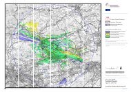
The development site is located towards the north of the Isle of<br />
Wight on the north-western fringe of Newport centred on grid<br />
reference E 448140 N 91146. The development site comprises<br />
the grounds of HMP Isle of Wight and is there<strong>for</strong>e bound by a<br />
large perimeter fence to the north and west. Three separate<br />
prisons, Camp Hill, Parkhurst and Albany and their associated<br />
buildings, make up HMP Isle of Wight and lie to the south and<br />
south-east of the development site. To the east of the site is the<br />
residential area of Parkhurst which is located along the A3020<br />
and to south beyond the prison lies the residential area of<br />
Hunny Hill along the A3054. A number of residential properties<br />
are also found beyond Noke Plantation along Noke Common to<br />
the north-east of the site.<br />
Access to the development site at Camp Hill is via the A3020<br />
on to Clissold Road from which the prison is accessed. Access<br />
will be taken via two routes; one from the north and one from<br />
the south. The northern route will be utilised to transfer all<br />
turbine components, site equipment and site structures and<br />
the southern route will be utilised to transfer all aggregate<br />
and ready mix concrete required by the development.<br />
The main body of the development site comprises of<br />
agricultural land predominantly open fields of grassland divided<br />
by hedges and mature trees. It is part of Holme Hill, a small hill,<br />
with the highest point being the northern central part of the site<br />
at around 65m above Ordnance Datum (AOD). It is bounded to<br />
the north and west by Parkhurst Forest which, in part, is a Site<br />
of Special Scientific Interest (SSSI) and a Site of Importance<br />
<strong>for</strong> Nature Conservation (SINC). To the east it is bounded by<br />
an area of <strong>for</strong>est known as Noke Plantation and to the south<br />
by further agricultural fields which, in turn, bound the prison<br />
buildings. Additionally the woodland to the immediate north<br />
and west of the development site boundary is designated as<br />
ancient woodland.<br />
The planning application is <strong>for</strong>:<br />
“The erection, 25 year operation and subsequent decommissioning<br />
of a wind energy development comprised of<br />
the following elements: two wind turbines with a maximum<br />
overall height (to vertical blade tip) of up to 125 metres;<br />
together with, offsite highway works, an upgraded junction<br />
off Parkhurst Road, modifications to the existing access track,<br />
new access tracks, hardstanding areas, a control building,<br />
cabling, a temporary construction compound, and other<br />
works and development ancillary to the main development.”<br />
Environmental Impact Assessment (EIA)<br />
EIA is a process that collects in<strong>for</strong>mation about potential<br />
environmental effects of a proposed development and<br />
evaluates and presents this in<strong>for</strong>mation in a way that both<br />
assists consultation and enables decision-makers to take<br />
account of these effects when determining whether or not<br />
a project should proceed. If the project does proceed the EIA<br />
also helps identify any mitigation measures or controls over<br />
the construction or operation that might be required. The<br />
content and scope of the EIA was agreed through a scoping<br />
exercise in April 2011 with the Isle of Wight Council.<br />
The EIA has identified the likely effects of the proposed<br />
development on the environment and an assessment has<br />
been made as to whether any of these could be significant.<br />
In general terms establishing whether an identified effect is<br />
significant is determined by the importance of the receptor<br />
(e.g. a particular listed building, ecological designated site<br />
or landscape character area) and the magnitude of change<br />
that will occur as a result of the construction, operation<br />
and de-commissioning of the turbines which, in turn,<br />
establishes the significance of that effect. Chapter 2 of the<br />
ES sets out the EIA methodology employed in more detail.<br />
To avoid or minimise any potential adverse effects identified<br />
a number of mitigation measures have been incorporated into<br />
the design of the proposed development. These measures<br />
are set out in a proposed Environmental Management Plan<br />
(EMP) (Chapter 15 of the ES) to be implemented during the<br />
construction and operation of the wind turbines.<br />
The Environmental Statement (ES) reports the findings<br />
of the EIA which has been prepared in accordance with<br />
The Town and Country Planning (Environmental Impact<br />
Assessment) Regulations 2011. The ES comprises this NTS<br />
and three volumes: Volume 1 – Written Statement, Volume<br />
2 – Figures and Volume 3 – Appendices.<br />
The assessment of effects has been undertaken in an<br />
impartial manner with the findings presented systematically<br />
in the ES and this will be used by the Isle of Wight Council to<br />
help in<strong>for</strong>m its decision about whether or not the proposed<br />
wind turbines at Camp Hill should be allowed to proceed.<br />
04