Non Technical Summary - Partnerships for Renewables
Non Technical Summary - Partnerships for Renewables
Non Technical Summary - Partnerships for Renewables

Create successful ePaper yourself
Turn your PDF publications into a flip-book with our unique Google optimized e-Paper software.
P<br />
PfR (HMP Camp Hill) Limited<br />
Camp Hill Wind Energy Development<br />
Environmental Statement - <strong>Non</strong> <strong>Technical</strong> <strong>Summary</strong><br />
Camp Hill Prison Wind Energy Development<br />
March 2012<br />
Figure xiii<br />
Viewpoint number: 4. View South-East from Entrance to Thorness Bay Holiday Park<br />
29703-E040.indd holfs<br />
1
P<br />
<strong>Non</strong> <strong>Technical</strong> <strong>Summary</strong><br />
Context<br />
This <strong>Non</strong>-<strong>Technical</strong> <strong>Summary</strong> (NTS) <strong>for</strong>ms part of the<br />
Environmental Statement (ES) which has been prepared by<br />
AMEC Environment & Infrastructure UK Ltd (AMEC) on behalf<br />
of <strong>Partnerships</strong> <strong>for</strong> <strong>Renewables</strong> (HMP Camp Hill) Limited<br />
(PfR) to accompany a planning application to construct<br />
and operate a wind energy development on land owned<br />
by the Ministry of Justice (MoJ) within the grounds of HMP<br />
Isle of Wight (Camp Hill). The ES presents the findings of<br />
an Environmental Impact Assessment (EIA) which aims to<br />
identify potentially significant effects from the proposed<br />
development and where appropriate to propose suitable<br />
mitigation measures to address or minimise any effects<br />
identified. This document is a ‘non-technical’ summary of<br />
the main findings of the ES.<br />
Vestas has had a presence on the Isle of Wight since 1993<br />
and currently employs 220 people there. The company is a<br />
world leading turbine manufacturer having installed 40,000<br />
turbines in 69 countries which equates to 40GW of capacity<br />
installed. The Vestas facility on the Isle of Wight is at the<br />
cutting edge of turbine design; researching, developing<br />
and testing new turbine blades. It also has the ability to<br />
manufacture blades and is an important showcase <strong>for</strong><br />
Vestas turbines <strong>for</strong> its potential customers.<br />
Recognising the important contribution which Vestas makes<br />
to the economy of the Isle of Wight PfR has established a<br />
relationship with them to secure Vestas as the preferred<br />
supplier of turbines to the site. Not only will this support an<br />
important local employer the turbines, once operational,<br />
would present the company with a further local opportunity<br />
to enhance Vestas’ R&D capabilities. The HMP Camp Hill<br />
project is wholeheartedly supported by Vestas and would be<br />
an important flagship development <strong>for</strong> them sustaining their<br />
continued commitment and investment on the Isle of Wight.<br />
Background<br />
The Intergovernmental Panel on Climate Change (IPCC),<br />
which is the principal scientific body advising governments<br />
on climate change, has confirmed the significant influence<br />
on the global climate of increases in atmospheric levels<br />
of carbon dioxide (CO 2) and other greenhouse gases as a<br />
result of human activities. The burning of fossil fuels such<br />
as coal and gas to generate electricity is a major source of<br />
greenhouse gas emissions. A vital part of reducing these<br />
emissions is increasing the proportion of electricity generated<br />
from renewable energy sources such as wind.<br />
The Climate Change Act 2008 sets a legally binding target<br />
of at least an 80% cut in UK greenhouse gas emissions<br />
by 2050. In the shorter term it sets a target reduction in<br />
emissions of at least 34% by 2020. In addition, as part of<br />
EU-wide actions to increase the use of renewable energy,<br />
the UK has a legally-binding commitment to source 15% of<br />
its energy from renewable sources by 2020. These targets<br />
<strong>for</strong>m the basis of the UK Renewable Energy Strategy which<br />
specifically includes the aspiration to generate 30% of the<br />
UK’s electricity from renewable sources by 2020.<br />
In 2010 just 6.8% of UK electricity came from renewables.<br />
The targets are set in order to combat climate change and<br />
provide the UK with a more secure energy supply by reducing<br />
reliance on imported fossil fuels. As the UK has one of the<br />
windiest climates in Europe a significant proportion of the<br />
electricity required from renewables is expected to come<br />
from onshore wind generation. In order to achieve national<br />
and regional targets <strong>for</strong> renewable energy generation and<br />
to trans<strong>for</strong>m the UK into a low carbon economy a range of<br />
large and small scale renewable energy installations will be<br />
required. As such the proposed two turbine wind energy<br />
development at Camp Hill will contribute to the attainment of<br />
these goals.<br />
Developer and Project Team<br />
PfR was set up by the Carbon Trust in 2006 to develop,<br />
construct and operate renewable energy projects primarily<br />
on public sector land. PfR manages the development of<br />
projects through site selection, assessment of site feasibility,<br />
layout design process, construction and operation.<br />
The EIA has been managed and co-ordinated by AMEC<br />
on behalf of PfR. AMEC Environment & Infrastructure<br />
UK Ltd is one of the UK’s largest environmental and<br />
engineering consultancies and part of a global Environment<br />
& Infrastructure division with 7,000 employees around<br />
the world. This division of the AMEC business delivers<br />
environmental, engineering and related consultancy services<br />
to customers across the public and private sectors. AMEC is<br />
an Institute of Environmental Management and Assessment<br />
(IEMA) Registered Assessor (the principle professional body<br />
<strong>for</strong> EIA in the UK) and is highly experienced in undertaking<br />
EIAs of wind energy developments with approximately<br />
1,250MW of development consented.<br />
Further specialist input came from Hoare Lea who undertook<br />
the noise assessment and The Heritage Collective who<br />
undertook the cultural heritage assessment. All other<br />
chapters were completed by AMEC.<br />
02 1
Camp Hill Wind<br />
Energy Development<br />
Number of Wind Turbines: 2<br />
Maximum Tip Height (combined<br />
height of blade and tower): 125 metres<br />
The Development Proposals<br />
The EIA process started when PfR began investigating the feasibility of<br />
locating a wind energy development on land owned by the MoJ in 2009.<br />
This involved a desk study that included consideration of wind resource,<br />
noise constraints, electrical connection potential, telecommunications,<br />
construction and access issues, environmental designations, landscape<br />
and visual aspects, archaeology and aviation.<br />
The Camp Hill site was identified as having good potential to support<br />
a wind energy development and was there<strong>for</strong>e progressed to a more<br />
detailed feasibility site visit, technical consultations, an assessment<br />
of grid connection and access options, preliminary noise modelling,<br />
energy yield analysis and a planning policy review. This feasibility<br />
study indicated that, potentially, the development site was technically,<br />
environmentally and financially viable <strong>for</strong> a wind energy development<br />
but that further assessment and clarification was needed.<br />
Estimated Total Generation Capacity:<br />
between 4 megawatts and 6 megawatts<br />
Estimated Capacity Factor: 25%<br />
Estimated Electricity Generated<br />
Per Annum: between 8.76 gigawatt-hours<br />
and 13.14 gigawatt-hours<br />
Households Equivalent:<br />
between 1,963 and 2,944<br />
Estimated CO 2 Savings:<br />
between 3,767 tonnes and 5,650 tonnes<br />
Please see foot note 1 <strong>for</strong> an explanation of how these<br />
figures are derived.<br />
PfR believes the development site to be suitable <strong>for</strong> a maximum of two wind<br />
turbines with a blade-tip height of up to 125m based on the considered<br />
application of technical, economic and environmental criteria. The amount<br />
of electricity which could be generated depends on the final specification<br />
of the turbines but the preferred choice of turbine to be installed is the<br />
Vestas V90 with an ‘installed capacity’ (the maximum amount of electricity<br />
which can be produced at any one time) of either 2MW or 3MW. If the<br />
Vestas machines are not available a number of other turbines with an<br />
‘installed capacity’ of between 2MW and 3MW are potentially suitable in<br />
which case the final choice would follow a competitive tendering exercise<br />
and depend on which models are available in the UK market. The following<br />
figures reflect this range in generation potential with the lower figures<br />
being based on 2MW turbines and the higher figures being based on 3MW<br />
turbines. Hence, two wind turbines with a maximum blade tip height of<br />
125m could generate between 8,760MWh and 13,140MWh of renewable<br />
electricity per year. This is equivalent to the amount of electricity used<br />
annually by approximately 1,963 to 2,944 average households and avoids<br />
between 3,767 and 5,650 tonnes of CO 2 equivalent emissions per year. 1 The<br />
methodology underlying these figures is explained in full in Section 6.3 of<br />
the ES.<br />
Section continues overleaf ><br />
03<br />
1<br />
The Digest of UK Energy Statistics (November 2011) gives 2010 domestic electricity<br />
consumption as 118,681 gigawatt-hours (GWh) (Shown in table as 118.68TWh) (http://<br />
www.decc.gov.uk/assets/decc/statistics/source/electricity/dukes5_1_2.xls) which, when<br />
divided by the number of households in the UK – 26,591,600 (http://www.decc.gov.uk/<br />
assets/decc/statistics/publications/ecuk/269-ecuk-domestic-2010.xls (table 3.3) – gives an<br />
average electricity usage of 4,463 kWh per year per household in the UK (118,681,000,000<br />
÷ 26,591,600 = 4,463). It is expected that two turbines with an installed capacity of<br />
2-3 MW could generate between 8.76 and 13.14 GWh of renewable electricity per year<br />
(based on a capacity factor of 25% – <strong>for</strong> onshore wind the five year average capacity<br />
factor (2006–2010 is 26.16% (Table 7.4 – http://www.decc.gov.uk/assets/decc/11/stats/<br />
publications/dukes/2309-dukes-2011-chapter-7-renewable-sources.pdf). These figures are<br />
derived as follows in the following example (using a 25% capacity factor): 6,000 kW (2 x 3<br />
MW turbine) × 8,760 hours/year × 0.25 (capacity factor) = 13,140,000 kWh. Based on the<br />
4,463 kWh household figure, and the predicted electricity generation of between 8.76 and<br />
13.14 GWh, it is estimated that the yearly output from the wind turbines will be equivalent to<br />
the approximate domestic electricity needs of between 1,963 and 2,944 average households<br />
in Britain (e.g. 13,140,000 ÷ 4463 = 2944). In September 2008, the Advertising Standards<br />
Authority endorsed a figure of 430 gCO 2 /kWh, based on the assumption that the energy<br />
generated by the wind turbines displaces Combined Cycle Gas Turbines and an average mix<br />
generation (430 gCO 2 /kWh). On this basis, and on the assumption that the wind turbines<br />
annual output is between 8.76 and 13.14 GWh, a wind energy development of this scale<br />
is expected to displace between 3,767 and 5,650 tonnes of CO2 equivalent emissions per<br />
year. These figures are derived as follows (using an output of 13.14 GWh as an example):<br />
13,140,000 kW (output) × 430 gCO2/kWh ÷ 1,000,000 = 5,650 tonnes CO 2 .
The Development Proposals continued ><br />
The Site Location Plan (Figure 1.1 of the ES) and Proposed<br />
Wind Energy Development Layout (Figure 1.2a of the ES) are<br />
reproduced at the end of this NTS along with a diagram of<br />
a typical wind turbine structure (Figure 4.1 of the ES) which<br />
is a 2MW-3MW machine with a 125m tip height. This is the<br />
maximum overall height (to vertical blade tip) of the turbine<br />
to be installed.<br />
The method of connection to the local distribution network<br />
has yet to be determined. Negotiations are underway<br />
currently between PfR and Scottish and Southern Electric<br />
to determine viable connection options; the anticipated<br />
option <strong>for</strong> the connection of the wind turbines is 3.5km of<br />
underground cabling within the public highway from the<br />
development site to Newport sub-station.<br />
The development site is located towards the north of the Isle of<br />
Wight on the north-western fringe of Newport centred on grid<br />
reference E 448140 N 91146. The development site comprises<br />
the grounds of HMP Isle of Wight and is there<strong>for</strong>e bound by a<br />
large perimeter fence to the north and west. Three separate<br />
prisons, Camp Hill, Parkhurst and Albany and their associated<br />
buildings, make up HMP Isle of Wight and lie to the south and<br />
south-east of the development site. To the east of the site is the<br />
residential area of Parkhurst which is located along the A3020<br />
and to south beyond the prison lies the residential area of<br />
Hunny Hill along the A3054. A number of residential properties<br />
are also found beyond Noke Plantation along Noke Common to<br />
the north-east of the site.<br />
Access to the development site at Camp Hill is via the A3020<br />
on to Clissold Road from which the prison is accessed. Access<br />
will be taken via two routes; one from the north and one from<br />
the south. The northern route will be utilised to transfer all<br />
turbine components, site equipment and site structures and<br />
the southern route will be utilised to transfer all aggregate<br />
and ready mix concrete required by the development.<br />
The main body of the development site comprises of<br />
agricultural land predominantly open fields of grassland divided<br />
by hedges and mature trees. It is part of Holme Hill, a small hill,<br />
with the highest point being the northern central part of the site<br />
at around 65m above Ordnance Datum (AOD). It is bounded to<br />
the north and west by Parkhurst Forest which, in part, is a Site<br />
of Special Scientific Interest (SSSI) and a Site of Importance<br />
<strong>for</strong> Nature Conservation (SINC). To the east it is bounded by<br />
an area of <strong>for</strong>est known as Noke Plantation and to the south<br />
by further agricultural fields which, in turn, bound the prison<br />
buildings. Additionally the woodland to the immediate north<br />
and west of the development site boundary is designated as<br />
ancient woodland.<br />
The planning application is <strong>for</strong>:<br />
“The erection, 25 year operation and subsequent decommissioning<br />
of a wind energy development comprised of<br />
the following elements: two wind turbines with a maximum<br />
overall height (to vertical blade tip) of up to 125 metres;<br />
together with, offsite highway works, an upgraded junction<br />
off Parkhurst Road, modifications to the existing access track,<br />
new access tracks, hardstanding areas, a control building,<br />
cabling, a temporary construction compound, and other<br />
works and development ancillary to the main development.”<br />
Environmental Impact Assessment (EIA)<br />
EIA is a process that collects in<strong>for</strong>mation about potential<br />
environmental effects of a proposed development and<br />
evaluates and presents this in<strong>for</strong>mation in a way that both<br />
assists consultation and enables decision-makers to take<br />
account of these effects when determining whether or not<br />
a project should proceed. If the project does proceed the EIA<br />
also helps identify any mitigation measures or controls over<br />
the construction or operation that might be required. The<br />
content and scope of the EIA was agreed through a scoping<br />
exercise in April 2011 with the Isle of Wight Council.<br />
The EIA has identified the likely effects of the proposed<br />
development on the environment and an assessment has<br />
been made as to whether any of these could be significant.<br />
In general terms establishing whether an identified effect is<br />
significant is determined by the importance of the receptor<br />
(e.g. a particular listed building, ecological designated site<br />
or landscape character area) and the magnitude of change<br />
that will occur as a result of the construction, operation<br />
and de-commissioning of the turbines which, in turn,<br />
establishes the significance of that effect. Chapter 2 of the<br />
ES sets out the EIA methodology employed in more detail.<br />
To avoid or minimise any potential adverse effects identified<br />
a number of mitigation measures have been incorporated into<br />
the design of the proposed development. These measures<br />
are set out in a proposed Environmental Management Plan<br />
(EMP) (Chapter 15 of the ES) to be implemented during the<br />
construction and operation of the wind turbines.<br />
The Environmental Statement (ES) reports the findings<br />
of the EIA which has been prepared in accordance with<br />
The Town and Country Planning (Environmental Impact<br />
Assessment) Regulations 2011. The ES comprises this NTS<br />
and three volumes: Volume 1 – Written Statement, Volume<br />
2 – Figures and Volume 3 – Appendices.<br />
The assessment of effects has been undertaken in an<br />
impartial manner with the findings presented systematically<br />
in the ES and this will be used by the Isle of Wight Council to<br />
help in<strong>for</strong>m its decision about whether or not the proposed<br />
wind turbines at Camp Hill should be allowed to proceed.<br />
04
Consultation<br />
A vital aspect of the EIA process is consultation both to agree<br />
which environmental topics need most attention (scope<br />
of the EIA and methodologies to be adopted in assessing<br />
likely effects) and to understand public perception of the<br />
development in order to help in<strong>for</strong>m the design process.<br />
Consultation with statutory and non-statutory bodies was<br />
undertaken through a <strong>for</strong>mal scoping exercise with the Isle<br />
of Wight Council in April 2011. In addition, there has been<br />
continued dialogue with relevant statutory and non-statutory<br />
consultees both be<strong>for</strong>e and after the Scoping Opinion (setting<br />
out the environmental topics to be considered further)<br />
was received from the Isle of Wight Council. The full list of<br />
consultees is set out in Chapter 3 of the ES and includes:<br />
Natural England; RSPB; Isle of Wight AONB Partnership; the<br />
Isle of Wight Council Archaeologist; the Isle of Wight Council<br />
Highways and Transport Department; and the Isle of Wight<br />
Council Ecologist.<br />
PfR has also undertaken public consultation involving public<br />
exhibitions and community surgeries with local residents<br />
dating back to 2010. PfR has held regular community<br />
surgeries at various stages of the project where PfR staff<br />
have been available to discuss the project in an in<strong>for</strong>mal<br />
setting with members of the public. These took place in<br />
February, May and September 2011. In February and March<br />
2012 update presentations were given in public to both<br />
Northwood and Newport parish councils. Public exhibitions<br />
were held in October 2010 and March 2012. A number of<br />
local groups such as the Footprint Trust have also been met<br />
with and kept up to date throughout the project development<br />
process. A separate Statement of Public Consultation has<br />
been produced and <strong>for</strong>ms part of the planning submission.<br />
Environmental Effects<br />
The scoping exercise identified a range of potential<br />
environmental effects. These were subjected to detailed<br />
assessments using methodologies specific to the relevant<br />
environmental topic. Those considered in this ES are listed<br />
as follows:<br />
• Climate change mitigation and other atmospheric<br />
emissions - Chapter 6;<br />
• Transport – Chapter 7;<br />
• Noise – Chapter 8;<br />
• Landscape and visual effects – Chapter 9;<br />
• Cultural heritage– Chapter 10;<br />
• Ecology (including impact on trees)– Chapter 11;<br />
• Ornithology – Chapter 12;<br />
• Hydrology – Chapter 13; and<br />
• Shadow Flicker – Chapter 14.<br />
The following sections provide a brief, non-technical,<br />
summary of the main findings of the EIA split by<br />
environmental topic. These findings are described in detail<br />
within the individual environmental topic chapters of the ES.<br />
The Environmental Statement<br />
The ES, which accompanies the planning application<br />
to the Isle of Wight Council, provides an assessment of<br />
identified significant environmental effects resulting from<br />
the construction, operation and de-commissioning of the<br />
proposed wind turbines at Camp Hill. The following sections<br />
provide a brief, non-technical, summary of the main findings<br />
of the EIA which are described in detail within the individual<br />
chapters of the full ES.<br />
Climate Change – Chapter 6<br />
The assessment of the effects on climate change involved<br />
a calculation of the expected renewable electricity that<br />
would be produced by the wind energy development. As<br />
set out above the assessment calculated that the proposed<br />
wind turbines could annually generate between 8,760MWh<br />
and 13,140MWh of renewable electricity per year. This is<br />
equivalent to the amount of electricity used annually by<br />
approximately 1,963 to 2,944 average households and<br />
avoids between 3,767 and 5,650 tonnes of CO 2 equivalent<br />
emissions per year. The ES concluded that maximising<br />
the renewable energy potential of the development site<br />
would result in a positive effect on climate change although<br />
it was not considered appropriate to assign any level of<br />
significance to this effect.<br />
Traffic and Transport – Chapter 7<br />
Estimates of traffic generation associated with the<br />
construction phase of the proposed Camp Hill Wind Energy<br />
Development have been derived from a first principles<br />
approach based on calculations of vehicle loads of<br />
imported materials.<br />
The most significant impacts will occur during the<br />
construction phase when there would be an increase in the<br />
volume of construction traffic utilising the surrounding road<br />
network to deliver the wind farm components, equipment<br />
and resources necessary <strong>for</strong> the construction. No impacts<br />
are expected during the operation of the site since the<br />
turbines will be controlled remotely and only occasional<br />
maintenance visits will be required which will most likely be<br />
undertaken in a 4x4 vehicle.<br />
The site will be accessed via two routes; one from the north<br />
and one from the south of the site. The intended routes<br />
broadly comprise:<br />
• Northern Route: Medina Wharf – Arctic Road – A3020 –<br />
Clissold Road - Site<br />
• Southern Route: A3056 – A3020 – Clissold Road - Site<br />
Section continues overleaf ><br />
05
Traffic and Transport – Chapter 7 continued ><br />
The northern route will facilitate the delivery of the turbine<br />
components and general site equipment and, <strong>for</strong> this<br />
reason; the northern route is the intended abnormal loads<br />
route. It is anticipated that the southern route will be used<br />
<strong>for</strong> the transfer of aggregate and ready mix concrete to the<br />
development site.<br />
Both routes will use Clissold Road to access the site and,<br />
upon reaching the main prison buildings, vehicles will route<br />
north along an improved access track and then northwest<br />
along a purpose built access track which will provide<br />
access to each of the turbine sites.<br />
The intended abnormal loads route has been subject to<br />
further assessment to identify potential sections of the<br />
route that will require highway widening works in order to<br />
facilitate the transfer of the turbine components. Three such<br />
sections, referred to as ‘pinch points’, have been identified<br />
and the following provides a brief summary of their location<br />
and mitigation works required:<br />
• Pinch Point A: Medina Wharf/Arctic Road junction – minor<br />
widening of the Arctic Road carriageway and relocation of<br />
boundary fencing and associated gate posts (upon exit<br />
from Medina Wharf).<br />
• Pinch Point B: Arctic Road/A3020 junction – rein<strong>for</strong>cement<br />
of the inside radius and widening of the carriageway into<br />
the verge area opposite the junction. Relocation of<br />
street furniture.<br />
• Pinch Point C: A3020/Clissold Road – localised widening<br />
of Clissold Road and minor footway rein<strong>for</strong>cement on the<br />
inside radius.<br />
Highway widening works at Pinch Points B and C will be<br />
permanent and subject to detailed design and liaison with<br />
the Isle of Wight Council. The detailed design of highway<br />
widening works at Pinch Point A will be temporary and<br />
subject to continued liaison with the owners of Medina Wharf.<br />
The impact of construction-related traffic on the proposed<br />
access routes has been calculated, in percentage terms,<br />
relative to the <strong>for</strong>ecast background traffic in 2013 as the<br />
opening year of construction.<br />
It is predicted that there will be an increase in total traffic<br />
flows during the assessment period of:<br />
• Survey Site 1 (Northern Route) – A3020 (Newport Road):<br />
Increase in total traffic of 0.02% and increase in HGVs<br />
of 0.02%<br />
• Survey Site 2 (Southern Route) – A3020 (Medina Way):<br />
Increase in total traffic of 0.13% and increase in HGVs<br />
of 0.13%<br />
There will also be two days during the construction<br />
programme when a maximum of 154 HGV movements<br />
per day (77 in and 77 out) <strong>for</strong> turbine foundation concrete<br />
deliveries will occur. In addition 18 abnormal load deliveries<br />
are required within the 6-month construction programme.<br />
Although both these activities will have a disproportionate<br />
but temporary effect on the highway network neither will<br />
exceed the 10% threshold increase in daily traffic flow.<br />
Increases in daily traffic flow below 10% are not normally<br />
perceived by road users due to the fluctuating nature of<br />
background traffic flow.<br />
Effects on road users and adjacent residential properties<br />
are considered to be not significant and works on the<br />
highway at each of the pinch points will affect road users<br />
and adjacent properties at varying degrees but only <strong>for</strong> a<br />
relatively short time period. Since there will be some impact<br />
during the construction of the site and during the mitigation<br />
works within the highway it is appropriate to make provision<br />
<strong>for</strong> some additional management in the <strong>for</strong>m of a Traffic<br />
Management Plan (TMP) to reduce the potential <strong>for</strong> effects<br />
as far as reasonably possible; this will also ensure any<br />
residual effects on highway safety are reduced. In addition to<br />
the TMP an Environmental Management Plan (EMP) will also<br />
be provided to reduce as far as possible the impacts of all<br />
abnormal load deliveries.<br />
It is considered that the local transport network would be<br />
able to absorb the additional traffic movements associated<br />
with the construction of the wind energy development and,<br />
there<strong>for</strong>e, that no significant effects would occur.<br />
Noise – Chapter 8<br />
Hoare Lea Acoustics (HLA) was commissioned by PfR to<br />
undertake a noise impact assessment <strong>for</strong> the construction and<br />
operation of the proposed Camp Hill Wind Energy Development.<br />
Two types of noise are emitted from wind turbines.<br />
Aerodynamic noise is produced by the movement of the<br />
blades through the air often characterised as a ‘swish’ and<br />
mechanical noise can come from the components within the<br />
turbine itself such as gearboxes and mechanisms to vary<br />
the direction of the turbine. Recent progress in reducing the<br />
noise from turbines has been considerable particularly, in<br />
relation to mechanical noise.<br />
The noise assessment established the difference between<br />
wind turbine noise and the naturally occurring noise<br />
level at homes (residential properties) nearest to the<br />
proposed development and measured these against levels<br />
required by planning guidance. Government guidance<br />
<strong>for</strong> this assessment procedure is called ETSU-R-97, The<br />
Assessment and Rating of Noise from Wind Farms and<br />
specifies that noise limits should be set relative to existing<br />
background noise levels and reflect a variation in wind<br />
speeds. In general terms, during the daytime, noise from<br />
Section continues overleaf ><br />
06
Noise – Chapter 8 continued ><br />
wind turbines needs to be no more than 5 decibels above<br />
existing background noise except where back ground noise<br />
levels are exceptionally quiet in which case permissible<br />
noise from turbines is fixed at between 35 decibels and 40<br />
decibels. During the night time noise from turbines needs to<br />
be no more than 43 decibels or 5 decibels above background<br />
whichever is the greatest.<br />
As set out above the preferred model of the wind turbine<br />
<strong>for</strong> this site is the Vestas V90 (2MW). However, if this is not<br />
available any turbine installed will comply with the noise<br />
limits identified in the assessment.<br />
During operation noise levels from the turbines have been<br />
predicted <strong>for</strong> those locations around the site most likely to be<br />
affected by noise. Surveys have been per<strong>for</strong>med to establish<br />
existing baseline noise levels at a number of these locations.<br />
Noise limits have been derived from data about the existing<br />
noise environment following the method stipulated in national<br />
planning guidance. Predicted operational noise levels have<br />
been compared to the limit values to demonstrate that<br />
turbines of the type and size which would be installed can<br />
operate within the limits so derived.<br />
Results of the noise modelling demonstrate that, during the<br />
operational phase of the development, noise from the wind<br />
turbines would be below the levels required by Government<br />
guidance (ETSU-R-97) at all residential properties both<br />
during the daytime and at night.<br />
During construction there may be noise that, at times, will<br />
be audible at the closest residential properties. This would<br />
primarily result from routine construction activities, deliveries<br />
and any piling required <strong>for</strong> the turbine foundations. Noise<br />
levels have been calculated <strong>for</strong> receiver locations closest to<br />
the areas of work and compared with guideline and baseline<br />
values. Construction noise, by its very nature, tends to be<br />
temporary and highly variable and there<strong>for</strong>e much less likely<br />
to cause an adverse effect. However, in order to ensure the<br />
protection of residential amenity, working hours and HGV<br />
deliveries would be limited and any turbine deliveries outside<br />
of this time would be agreed with the Isle of Wight Council<br />
and the Police. All construction activities would adhere to<br />
good practice set out in BS 5228. It is concluded that overall<br />
effects relating to noise generated through construction<br />
activities will be minor. The ES states that noise emissions<br />
during de-commissioning are considered to be lower than<br />
during the construction phase. There<strong>for</strong>e de-commissioning<br />
will, in the worst case, also have a minor noise effect.<br />
The ES there<strong>for</strong>e concludes that, overall, there would be no<br />
significant noise effects from the operation of the proposed<br />
wind turbines.<br />
Landscape and Visual – Chapter 9<br />
The Landscape and Visual Assessment (LVIA) chapter<br />
identifies and assesses the potential effects of the proposed<br />
Camp Hill Wind Energy Development and determines the<br />
significance of these effects. Landscape and visual effects<br />
are defined as follows:<br />
• Landscape effects that are changes in the fabric,<br />
character and quality of the landscape. These could<br />
include direct effects upon specific landscape elements<br />
such as the loss of a woodland or hedgerows or effects<br />
on landscape character and landscape designations; and;-<br />
• Visual effects that relate to specific changes in the<br />
character of views and the effects of those changes on<br />
visual receptors e.g. people who use of roads, Public<br />
Rights of Way and recreational facilities as well as residents.<br />
The methodology used within the LVIA takes into<br />
consideration best practice as set out in Guidelines <strong>for</strong><br />
Landscape and Visual Impact Assessment, Second Edition<br />
(2002) published by The Landscape Institute and Institute<br />
of Environmental Management and Assessment. The LVIA<br />
methodology sets out that only levels of landscape or visual<br />
effects assessed as being of very substantial, substantial<br />
or, in some cases, moderate may be regarded as significant<br />
effects in EIA terms.<br />
Consultation was carried out through the scoping process<br />
with the Isle of Wight Council along with the Isle of Wight<br />
AONB Partnership and Natural England in order to confirm<br />
an initial ten viewpoint locations to be considered within the<br />
LVIA. The scoping response agreed to the inclusion of these<br />
viewpoints and suggested a further nine viewpoints. These<br />
suggestions were incorporated; hence the LVIA includes<br />
visualisations and analysis from nineteen viewpoints<br />
including three on the mainland. For the fifteen closest<br />
viewpoints baseline panoramic photographs, wire line<br />
representations and photomontages have been generated<br />
to be used as a tool to demonstrate how the proposed<br />
turbines may appear. In line with emerging best practice and<br />
experience only wire line representations were produced <strong>for</strong><br />
the five most distant viewpoints.<br />
In selecting the study area <strong>for</strong> the LVIA reference was made<br />
to ‘Visual Representation of Windfarms, Good Practice<br />
Guidance, Scottish Natural Heritage 2006’. However, initial<br />
studies undertaken during the scoping study strongly<br />
indicated that a reduced study area would be more<br />
appropriate given the island location and the small number<br />
of turbines proposed. Hence study areas have been adopted<br />
as below:<br />
• 1km from either of the two proposed turbines <strong>for</strong> visual<br />
assessment of individual residential properties;<br />
Section continues overleaf ><br />
07
Landscaoe and Visual – Chapter 9 continued ><br />
• 10km from the proposed development <strong>for</strong> assessment<br />
of effects on local landscape character and the majority<br />
of visual receptors. This is referred to as the detailed study<br />
area and covers nearly all the areas of the Island from<br />
where the proposed turbines would be potentially visible;<br />
• 20km from the proposed development <strong>for</strong> assessment<br />
of effects on settlements, National Trails and national<br />
landscape designations; and<br />
• 40km from the proposed development <strong>for</strong><br />
cumulative effects.<br />
A cumulative scoping exercise was carried out which<br />
identified three wind energy developments and a biomass<br />
CHP plant with a tall chimney stack to be included in the<br />
cumulative assessment.<br />
The development site is not located within any national<br />
or local landscape planning designations and is located<br />
approximately 2.5km from the Isle of Wight Area of<br />
Outstanding Natural Beauty (AONB) and approximately 8km<br />
away from the New Forest National Park which is located on<br />
the mainland.<br />
The Isle of Wight Council has undertaken detailed studies<br />
which have characterised the different landscapes of the<br />
Isle of Wight. The proposed turbines are located within the<br />
Northern Woodlands’ landscape character type (LCT) which<br />
extends across Parkhurst Forest and some of its adjacent<br />
fields and the surrounding area is defined as Traditional<br />
Enclosed Pasture Land LCT or Calbourne Farmland<br />
Landscape Character Area (LCA).<br />
The development site is located on the eastern side of the<br />
395ha Parkhurst Forest which comprises of mature, mixed<br />
broadleaf and conifer woodland which extends around the<br />
development site’s western and northern edges. Another<br />
mature woodland, Noke Plantation, <strong>for</strong>ms the development<br />
site’s eastern edge providing it with a strong sense of<br />
enclosure. To the south is a valley containing a number of<br />
unkempt pasture fields which separate it from the HMP<br />
Isle of Wight site including Camp Hill, Albany and Parkhurst<br />
Barracks. Parkhurst Forest contains a number of trails which<br />
are open to public use but there is no public access to the<br />
site itself or in its immediate vicinity. There are moderate<br />
levels of public access approximately 1km from the<br />
proposed development.<br />
In the wider context there are ten long-distance trails mostly<br />
concentrated in the southern part of the island with the<br />
exception of the Isle of Wight Coastal Path which skirts the<br />
whole perimeter. These have been assessed and there will<br />
be no “substantial adverse” or “very substantial adverse”<br />
effects experienced at any of these receptors. The centre<br />
of Newport, the island’s largest town, lies some 2.8km to<br />
the south-east and its northern suburb of Parkhurst extends<br />
along the A3020 approximately 1km to the east. The small<br />
towns of Cowes and East Cowes also lie within 5km.<br />
Otherwise the prevailing settlement pattern in the detailed<br />
study area is of small settlements distributed in a medium<br />
density interspersed with farmsteads and isolated or small<br />
clusters of residential properties. There are also a number<br />
of holiday parks and tourist attractions 1.5km from the<br />
proposed development site and beyond.<br />
In terms of effects on the receptors mentioned above<br />
during the construction and de-commissioning phases both<br />
landscape and visual effects are considered to be temporary<br />
in nature and short term. This results in landscape and<br />
visual effects being not significant although there would<br />
be a limited number of visual receptors likely to sustain<br />
moderate adverse levels of visual effect during the shortlived<br />
period when the turbines are actually being erected by<br />
crane and their rotor blades attached. During construction<br />
and de-commissioning this relatively low level of landscape<br />
and visual effect is mainly due to the low numbers of close<br />
distance visual receptors and the screening of all ground<br />
level construction activities by the surrounding woodlands.<br />
During the 25-year operational period no significant effects<br />
have been identified that would be greater than “moderate<br />
adverse” on any landscape elements, character areas or<br />
types or upon landscape designations. Moderate adverse<br />
landscape effects have been identified <strong>for</strong> the Northern<br />
Woodlands LCT within which the wind energy development<br />
would be sited and the a<strong>for</strong>ementioned surrounding<br />
Traditional Enclosed Pasture Land LCT and Calbourne<br />
Farmland LCA. In the areas from which the turbines could<br />
potentially be seen, the separation distances from and the<br />
most valued attributes of the AONB and Heritage Coasts are<br />
assessed in detail and it is concluded that landscape effects<br />
would be no more than “slight adverse”. Consequently, no<br />
significant effects were identified <strong>for</strong> the Isle of Wight AONB,<br />
the Heritage Coast or the New Forest National Park.<br />
In addition to the nineteen agreed visualisation viewpoints<br />
the visual assessment included 118 individual or, more<br />
usually, groups of visual receptors located on the island<br />
and within 10km of the proposed development site. Of<br />
these visual receptors it is concluded that nine individuals<br />
or groups would be likely to sustain “substantial adverse”<br />
visual effects and a further twenty-four individual or groups<br />
would be likely or certain to sustain “moderate adverse”<br />
visual effects. However, no visual receptors would sustain<br />
“very substantial adverse” visual effects. These relatively<br />
low numbers of instances where “moderate” or “substantial”<br />
adverse visual effects would be experienced is due to the<br />
fact that there is, in fact, a relatively small number of visual<br />
receptors located in close proximity to the development site.<br />
Furthermore, screening provided by the high level of tree<br />
cover nearby will help to <strong>for</strong>eshorten many potential views<br />
<strong>for</strong> residents in properties such as those at the western<br />
end of Noke Common and Mark’s Corner. The aspect and<br />
Section continues overleaf ><br />
08
Landscaoe and Visual – Chapter 9 continued ><br />
principal views of some properties, such as those on Rooke<br />
Street in Parkhurst, will also limit the level of visual effect. For<br />
many visual receptors with potential medium distance views<br />
the proposed two turbines would be screened by the island’s<br />
distinct land<strong>for</strong>m especially the chalk ridge “spine” that runs<br />
west -east across its centre as well as relatively high levels<br />
of hedgerow, hedgerow tree, copse and plantation woodland<br />
that are characteristic of the two adjacent and extensive<br />
landscape character types and areas.<br />
Those receptors assessed as sustaining “substantial” or<br />
“moderate adverse effects” are generally a proportion<br />
of the residents in properties on the north-western edge<br />
of Newport or properties alongside or just off the A3020<br />
where their main views are likely to be to the north-west,<br />
west or south-west and where nearby screening is limited.<br />
In addition to the above “moderate adverse effects” may<br />
be sustained at sections of some public rights of way at<br />
separation distances of up to 3.5km or, in two instances,<br />
up to 5km. In no instance will public rights of way sustain<br />
“substantial adverse” or “very substantial adverse” effects.<br />
With regard to effects upon residential visual amenity a<br />
combination of separation distance, the screening of ground<br />
level operational elements and the narrowness of the turbine<br />
array <strong>for</strong>med by only two turbines would ensure that no<br />
residential visual receptors would reasonably have the<br />
sense that their property would be ‘widely regarded as an<br />
unattractive place to live’.<br />
Finally the cumulative landscape and visual assessment<br />
concluded that in only one area, around Bowcombe Down,<br />
would the combination of the Camp Hill Wind Energy<br />
Development with the other developments included in the<br />
assessment result in a higher level of visual effect than would<br />
be experienced in relation to the Camp Hill turbines on their<br />
own or the other developments excluding Camp Hill. There<br />
would be no significant cumulative landscape effects upon any<br />
landscape designations or landscape character types or areas.<br />
Cultural Heritage – Chapter 10<br />
Background historical and archaeological data was compiled<br />
and a site walkover survey undertaken in order to in<strong>for</strong>m<br />
the assessment. The assessment was undertaken in<br />
accordance with current best practice and policy guidance<br />
including Planning Policy Statement 5: Planning <strong>for</strong> the<br />
Historic Environment (Department of Communities and Local<br />
Government 2010), the Practice Guide (English Heritage<br />
2010), the Guidance Note on the Setting of Heritage Assets<br />
(2011) and the Local Unitary Development Plan. Consultation<br />
was undertaken with English Heritage and the Isle of Wight<br />
Planning Archaeologist.<br />
Designated heritage assets in the area were visited in<br />
order to assess the possible effect on their setting. Through<br />
experience of production of numerous Environmental<br />
Statements it has been demonstrated that significant effects<br />
rarely occur beyond a distance of 10km and the highest level<br />
effects are generally within 3.5km.<br />
Effects on listed buildings, conservation areas, scheduled<br />
monuments and registered historic parks and gardens<br />
within 5km were assessed; <strong>for</strong> example, the Carisbrooke<br />
Conservation Area, which includes both the parish Church of<br />
St Mary, a grade I listed building and Carisbrooke Castle, a<br />
scheduled monument and a grade I listed building all of which<br />
lie over 3km to the south of the development site. Assessment<br />
of Osborne House registered park and garden at 5km and the<br />
buildings at Parkhurst Prison and St Mary’s Hospital within<br />
1.5km of the development site was also undertaken.<br />
Whilst the wind turbines would <strong>for</strong>m a visible and<br />
recognisable new element within the landscape the<br />
assessment concluded that it would not detract from the<br />
character or significance of the surrounding heritage assets.<br />
However, the proposed development is assessed as having<br />
moderate adverse effect on the setting of the Carisbrooke<br />
Conservation Area together with the parish Church of St Mary<br />
as a result of the appearance of turbines within a specific<br />
number of views towards the church within the settlement.<br />
Moderate effects are also identified on Carisbrooke Castle.<br />
The physical effect on all heritage assets, including buried<br />
archaeological remains and other historic structures within<br />
the footprint of the proposed development, including<br />
associated services, construction compound, electrical cable<br />
connections and on/off site access routes was assessed<br />
through a desk study and site visit.<br />
The desk study comprised the identification of known<br />
designated and non-designated assets within the<br />
development area to assess the potential <strong>for</strong> effects on buried<br />
archaeological deposits and other historic features. This drew<br />
from the Isle of Wight Council Historic Environment Record,<br />
National Monument Record, historic Ordnance Survey maps<br />
and other available published resources in order to describe<br />
the history and development of the site.<br />
The assessment concluded that the potential <strong>for</strong> archaeological<br />
deposits to be affected during the construction phase is<br />
low with the exception of potential finds relating to the<br />
development site’s use as a rifle range during the late 19th<br />
and early 20th century in association with Parkhurst Barracks.<br />
Consequently a watching brief (archaeological supervision of<br />
works) would be undertaken during construction.<br />
Ecology – Chapter 11<br />
A desk study and field surveys were undertaken at the<br />
site in 2010 and 2011 including extended phase 1 habitat,<br />
dormouse, red squirrel, reptiles and bat surveys. Detailed bat<br />
survey work included an assessment of potential roost sites,<br />
manual bat detector transect surveys at dusk, dawn re-entry<br />
surveys of trees with roosting potential, static detector surveys<br />
at ground level and static detector surveys at height.<br />
Section continues overleaf ><br />
09
Ecology – Chapter 11 continued ><br />
Given the scheme design, which has evolved to minimise<br />
effects on potential ecological receptors, the proposed<br />
development was deemed unlikely to result in any effects on<br />
species or habitats with the exception of seven bat species.<br />
Further assessment was there<strong>for</strong>e required to consider effects<br />
on common pipistrelle, noctule, serotine, Leisler’s bat, soprano<br />
pipistrelle, Nathusius’ pipistrelle and barbastelle.<br />
These species have been recorded <strong>for</strong>aging and commuting<br />
on site and may potentially roost within adjacent woodland.<br />
Common pipistrelle, soprano pipistrelle, serotine and<br />
barbastelle are all species considered to be at medium<br />
risk from collision with wind turbine while noctule, Leisler’s<br />
and Nathusius’ pipistrelle are considered to be at high risk.<br />
The assessment of effects of the scheme took into account<br />
the status of all these species in the UK and the Isle<br />
of Wight as well as the activity levels recorded on site.<br />
Prior to implementation of mitigation measures it was<br />
concluded that slight effects may occur on common<br />
pipistrelle, serotine and Nathusius’ pipistrelle whilst<br />
moderate effects may occur on Leisler’s bat and noctule.<br />
Barbastelle is sufficiently rare that it was considered that<br />
moderate-substantial effects may occur on this species.<br />
Mitigation measures have been proposed which include<br />
vegetation clearance from below the wind turbines to<br />
discourage <strong>for</strong>aging bats as well as a programme of postdevelopment<br />
monitoring to in<strong>for</strong>m appropriate additional<br />
mitigation if required. As a result of these measures being<br />
implemented it has been concluded that slight negative<br />
residual effects would occur only to noctule, Leisler’s bat<br />
and barbastelle. These effects are not considered likely to<br />
be increased as a result of cumulative effects from other<br />
wind energy developments within 10km.<br />
No significant effects in terms of the EIA regulations are<br />
identified in relation to ecology.<br />
Ornithology – Chapter 12<br />
The assessment methodology was based upon guidance<br />
from the Institute of Ecology and Environmental Management<br />
(IEEM), Scottish Natural Heritage (SNH) (Survey Methods <strong>for</strong><br />
Use in Assessing the Impacts of Onshore Windfarms on Bird<br />
Communities) and Natural England (TIN069: Assessing the<br />
Effects of Onshore Windfarms on Birds). Consultation was<br />
carried out with Natural England, the Isle of Wight Council<br />
and the RSPB concerning the studies required and the<br />
appropriate issues to be addressed in the assessment of<br />
notable bird species.<br />
The site is predominately open farmland bounded to the<br />
south and south-east by the prisons and their associated<br />
infrastructure. Immediately to the north and west of the site<br />
boundary is Parkhurst Forest of which part is designated<br />
as a Site of Special Scientific Interest (SSSI) and a Site<br />
of Importance <strong>for</strong> Nature Conservation (SINC). In order to<br />
determine the ornithological baseline a desk study and a<br />
range of site field surveys were conducted and subsequent<br />
collision modelling undertaken, where considered necessary,<br />
to assess the effects of the wind turbines on bird species. In<br />
general terms, turbines can affect birds in four particular ways;<br />
habitat loss, disturbance, displacement and collision. For each<br />
phase of the development; construction, operation and decommissioning<br />
the ES assessed whether these effects would<br />
be significant on the bird species of conservation importance<br />
recorded on the site.<br />
The desk study included a review of existing statutory sites<br />
of ornithological interest and records of bird species were<br />
received from the Isle of Wight Local Records Centre. A full<br />
year of surveys were undertaken within and around the<br />
site comprising vantage-point watches, territory mapping<br />
surveys, species-specific nightjar and barn owl surveys<br />
and winter walkover surveys. During all surveys (October<br />
2010 – September 2011) a total of 74 bird species were<br />
recorded within the survey area. 22 species were classified<br />
as confirmed or probable breeders within the site boundary<br />
(and 40 species within the wider survey area).<br />
Four species were classified as ‘target species’ (Barn owl,<br />
hobby, nightjar and Mediterranean gull) during 12 months<br />
of surveys; of these barn owl was the only target species<br />
recorded breeding within the site whilst hobby and nightjar<br />
were recorded breeding within the wider survey area. Overall<br />
the ES identified that:<br />
• Barn owls breed within the site and <strong>for</strong>age extensively<br />
over grassland fields within and around the site;<br />
however, this species is not susceptible to collision<br />
risk and, given the distance between the nest site and<br />
proposed construction areas, disturbance effects are<br />
likely to be negligible and there<strong>for</strong>e not significant.<br />
• Based on collision risk assessment and European studies<br />
hobby is not considered to be susceptible to collision with<br />
turbine blades; as such, given the limited time this species<br />
spent within either the site or within the flight space of the<br />
proposed turbines, collision risk to this species is considered<br />
not significant. In terms of avoiding disturbance of nesting<br />
birds a 500m construction buffer around the nest site will<br />
be observed between April and July and a 350m buffer<br />
between August and October. As a result the magnitude<br />
of construction disturbance effects on breeding hobby<br />
would be negligible and thus not significant.<br />
• Based on several British studies nightjar is not considered<br />
to be susceptible to collision with turbine blades and, as<br />
such, risk of collision <strong>for</strong> this species at Camp Hill is<br />
negligible and there<strong>for</strong>e not significant. In addition, given<br />
the distance from the site and the extent of woodland<br />
cover between territory locations and proposed construction<br />
areas, the magnitude of effects of construction disturbance<br />
on nesting nightjar is there<strong>for</strong>e considered to be negligible<br />
and, thus, not significant.<br />
Section continues overleaf ><br />
10
Ornithology – Chapter 12 continued ><br />
Mediterranean gull and peregrine falcon were both only<br />
recorded infrequently and, there<strong>for</strong>e, no significant effects<br />
are predicted <strong>for</strong> either species. In addition, as the site is of<br />
low value of the site <strong>for</strong> waders and passerines, no significant<br />
effects are predicted <strong>for</strong> either group as a result of the scheme.<br />
Given the distance between the site and all statutory<br />
designated sites of ornithological interest (SSSI/SPA/Ramsar)<br />
within 20km and, given the limited activity of qualifying<br />
interest species (both breeding and wintering species) within<br />
and above the site, the proposed development is unlikely to<br />
pose a significant threat to qualifying interest species.<br />
A full list of species recorded can be found in Chapter 12<br />
of the ES.<br />
In line with standard construction practices vegetation<br />
clearance will be undertaken outside of the bird nesting<br />
season and, if required, nest location surveys would be<br />
undertaken prior to beginning work. All procedures would<br />
be agreed with the appropriate consultees and comply with<br />
relevant legislation.<br />
No significant effects in terms of the EIA regulations are<br />
identified in relation to ornithology.<br />
Hydrology – Chapter 13<br />
The hydrology assessment identified the existing surface<br />
and sub-surface water environment and ground conditions<br />
to establish a baseline against which potential effects<br />
were evaluated. Generally the development site has a<br />
water environment with low sensitivity/importance: the<br />
development site is located on Holme Hill and watercourses<br />
on it comprise small field drains which were dry during<br />
the site visit in March 2012. However, some of the small<br />
drains/watercourses flow into the River Medina which is<br />
classified as a Special Area of Conservation and includes<br />
the Dodnor Creek Nature Reserve. The underlying geology<br />
comprises clays, silts and sands of the Solent Group which<br />
generally do not store significant quantities of groundwater.<br />
The hydrological receptors have there<strong>for</strong>e been classified<br />
as being between negligible and low sensitivity to high<br />
sensitivity depending on where they drain to. Hydrological<br />
constraints were identified and, except <strong>for</strong> essential<br />
watercourse crossings, the design has avoided development<br />
in buffer zones established around watercourses.<br />
Flood risk has also been considered <strong>for</strong> the proposed<br />
development. The site is located in a low-risk flood zone and<br />
the footprint of the development means that it is unlikely that<br />
flood risk elsewhere will be increased. Access track surfaces<br />
and crane pads will be constructed using semi-permeable<br />
granular material to allow rainfall to infiltrate so that surface<br />
run-off from the development site will not increase.<br />
Prior to any construction works an Environmental Management<br />
Plan (EMP) will be prepared and agreed. As part of the plan<br />
a detailed ground investigation study will be undertaken; the<br />
study will include both geotechnical and geo-environmental<br />
techniques in order to assess the ground conditions and<br />
to identify the depth and water quality of any shallow<br />
groundwater present. The results of the study will be used to<br />
determine the foundation type <strong>for</strong> the turbines and any ground<br />
treatments that may be required.<br />
The EMP will detail all appropriate mitigation measures during<br />
construction; these will include dust control measures and<br />
the safe storage of on-site fuels and equipment. The CEMP<br />
will also identify a number of mitigation measures that will be<br />
used during the construction, operation and de-commissioning<br />
phases of the turbine; these measures will include the<br />
appropriate design of hard standing areas, access tracks and<br />
the turbine foundations. These measures are designed to avoid<br />
surface water run-off and to reduce localised interference of<br />
groundwater recharge.<br />
With the CEMP in place it is considered that there will be<br />
no significant effects on the ground conditions or on the<br />
water environment during the construction, operation and<br />
de-commissioning phases of the turbine development.<br />
It is concluded that the proposed wind energy development<br />
will have no significant effects in terms of water quality and<br />
or surface water run-off.<br />
Shadow Flicker – Chapter 14<br />
Shadow flicker can occur within occupied buildings when the<br />
moving shadow from a wind turbine blade repeatedly passes<br />
over a window or opening. The effect is most pronounced<br />
when the blade shadow entirely obscures a narrow window<br />
opening thereby causing a greater reduction in internal light<br />
levels than if the shadow moves across a larger opening. As<br />
detailed in the relevant national planning policy document:<br />
‘Planning <strong>for</strong> Renewable Energy: A Companion Guide to<br />
PPS22’ in order <strong>for</strong> shadow flicker to occur buildings need to<br />
be located within 10 rotor diameters (900m in the case of a<br />
turbine with a rotor diameter of 90m). This was endorsed in<br />
the recent study undertaken on behalf of the Department of<br />
Energy and Climate Change, ‘Update of UK Shadow Flicker<br />
Evidence Base – Final Report’ (2011). Within the 10 rotor<br />
diameter distance <strong>for</strong> shadow flicker to occur there must be<br />
sufficient sunshine, windows need to be facing the turbines<br />
with no significant intervening structures or vegetation, the<br />
turbines need to be operating and, due to the position of the<br />
sun in the sky, the receptor must be located 130º either side<br />
of north from the turbines. In general terms shadow flicker<br />
normally occurs during the early morning and evening when<br />
the sun is at its lowest elevation in the sky. Only in these<br />
circumstances will there be a potential <strong>for</strong> shadow flicker to<br />
affect residential amenity.<br />
Concerns are sometimes raised that shadow flicker may<br />
trigger photosensitive epilepsy which can occur as a result of<br />
light flashes at frequencies between 2.5Hz-3Hz. The blades<br />
Section continues overleaf ><br />
11
Shadow Flicker – Chapter 14 continued ><br />
of modern wind turbines such as those proposed at Camp Hill<br />
rotate at a speed of less than 20rpm so, as a turbine has<br />
three blades, in any one minute there will be a maximum of<br />
60 blade shadows equating to a rotational speed of 60rpm.<br />
This equates to 1Hz which is below the 2.5Hz minimum<br />
required to trigger epilepsy. This in<strong>for</strong>mation is derived from<br />
Government and independent research as detailed in the ES.<br />
The duration of potential shadow flicker has been<br />
accurately modelled in the ES using software which uses<br />
the known position of the sun in the sky <strong>for</strong> every minute<br />
of the year. Assuming worse-case conditions (sufficient<br />
daylight, correct alignment of the blades and no obstacles<br />
between the window and the turbines) potential shadow<br />
flicker effects were predicted in the ES at some thirtyfive<br />
residential properties/prison accommodation blocks<br />
and, of these, fifteen were assessed in detail since some<br />
properties are located on the same street and adjacent<br />
to each other i.e. a representative sample was analysed<br />
further rather than every property individually. The highest<br />
predicted level of shadow flicker effects <strong>for</strong> properties was<br />
an average of 49 minutes per day up to 56 days per year.<br />
The maximum predicted occurrence of shadow flicker<br />
throughout the year is 45 hours. This assumes that the<br />
sun is always shining during daylight hours and there is no<br />
screening or obstruction i.e. from trees, hedges, structures,<br />
etc. Realistically however, in the UK, the sun shines <strong>for</strong><br />
approximately one third of daylight hours and, if this is<br />
taken into consideration, the likely effect would significantly<br />
reduce to a maximum average of 17 minutes per day on up<br />
to 56 days per year and the maximum predicted occurrence<br />
of shadow flicker throughout the year would be 15 hours<br />
per year.<br />
Further In<strong>for</strong>mation<br />
Printed copies of the non-technical summary and ES<br />
(including figures and appendices) may be obtained from<br />
<strong>Partnerships</strong> <strong>for</strong> <strong>Renewables</strong>, Station House, 12 Melcombe<br />
Place, London, NW1 6JJ. The non-technical summary is<br />
available free of charge and a limited number of hard copies<br />
of the Environmental Statement are available <strong>for</strong> £500 per<br />
copy. A limited number of CDs/DVDs containing PDF files of<br />
the Environmental Statement are available <strong>for</strong> £15 per CD/<br />
DVD. Alternatively, these electronic files can be downloaded<br />
from http://www.pfr.co.uk/camphill.<br />
Copies of the Environmental Statement may be viewed at<br />
the following location during opening hours:<br />
Isle of Wight Council<br />
Council Offices<br />
Seaclose<br />
Fairlee Road<br />
Newport<br />
Isle of Wight<br />
PO30 2QS<br />
Where shadow flicker effects occur at properties mitigation<br />
measures will be put in place which could include planting,<br />
garden screening or operational controls on the turbines by<br />
way of a programmed shut down.<br />
The shut down system would use a device to measure the<br />
intensity of sunlight occurring at a particular moment and<br />
would use this, together with time and date in<strong>for</strong>mation<br />
programmed into the device, to determine whether shadow<br />
flicker will occur. If the intensity of sunlight is above that<br />
which is required to cause a shadow flicker effect and<br />
the time of day corresponds with a predicted effect the<br />
automatic programme would shut down the wind turbine<br />
until the time period when shadow flicker may occur has<br />
passed and the turbine would re-start automatically.<br />
If required the available mitigation which is normally<br />
secured via a planning condition would result in no<br />
significant effects resulting from shadow flicker.<br />
12 1
N<br />
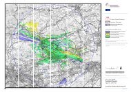
Key<br />
<br />
Development Site Boundary<br />
Turbine Location<br />
Temporary Construction<br />
Compound (50m x 50m)<br />
Crane Pad (1500m2)<br />
Onsite Control Building<br />
(8m x 8.5m + 1.5m walkway)<br />
Onsite Cable Route and Ducts<br />
Anticipated Route of Underground<br />
Electricity Cable<br />
New Access Tracks<br />
Existing Upgraded Track<br />
New Culvert<br />
Upgrade Existing Culvert<br />
1<br />
2<br />
Existing Junction Upgraded<br />
Note: micrositing clearance of 15 m<br />
0m<br />
360m<br />
Scale 1:6,000 @ A3<br />
Camp Hill Wind Energy Development<br />
Planning Application<br />
Figure 3<br />
Proposed Wind Energy Development<br />
Layout<br />
March 2012<br />
29703-02 E189b rowab<br />
Based upon Ordnance Survey digital data with the permission of the Controller of the Stationery Office Crown Copyright Reserved. Licence No: AL100001776
P<br />
Station House 12 Melcombe Place London NW1 6JJ t: +44 (0)207 170 7000 f: +44 (0)207 170 7020 e: info@pfr.co.uk<br />
www.pfr.co.uk<br />
<strong>Partnerships</strong> <strong>for</strong> <strong>Renewables</strong> Development Company Limited Registered in England and Wales, number 06526742 Registered at 4th Floor, Dorset House, 27-45 Stam<strong>for</strong>d Street, London, SE1 9PY