

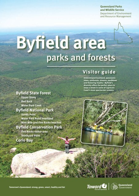
Byfield area parks and forests visitor guide - Department of National ...
Byfield area parks and forests visitor guide - Department of National ...
Byfield area parks and forests visitor guide - Department of National ...

You also want an ePaper? Increase the reach of your titles
YUMPU automatically turns print PDFs into web optimized ePapers that Google loves.
Queensl<strong>and</strong> Parks<br />
<strong>and</strong> Wildlife Service<br />
<strong>Department</strong> <strong>of</strong> Environment<br />
<strong>and</strong> Resource Management<br />
<strong>Byfield</strong> <strong>area</strong><br />
<strong>parks</strong> <strong>and</strong> <strong>forests</strong><br />
Visitor <strong>guide</strong><br />
<strong>Byfield</strong> State Forest<br />
Upper Stony<br />
Red Rock<br />
Water Park Creek<br />
<strong>Byfield</strong> <strong>National</strong> Park<br />
S<strong>and</strong>y Point<br />
Water Park Point headl<strong>and</strong><br />
Nine Mile <strong>and</strong> Five Rocks beaches<br />
<strong>Byfield</strong> Conservation Park<br />
Five Rocks <strong>visitor</strong> <strong>area</strong><br />
Stockyard Point<br />
Corio Bay<br />
Undeveloped bushl<strong>and</strong>, panoramic<br />
views, rain<strong>forests</strong>, streams, s<strong>and</strong>blows<br />
<strong>and</strong> flowering heaths—<strong>Byfield</strong>’s<br />
diversity <strong>of</strong>fers the perfect place to<br />
enjoy a break in some <strong>of</strong> Capricorn<br />
Coast’s most spectacular scenery.<br />
Tomorrow’s Queensl<strong>and</strong>: strong, green, smart, healthy <strong>and</strong> fair
<strong>Byfield</strong>’s <strong>parks</strong> <strong>and</strong> <strong>forests</strong>—approximately<br />
39 000 ha—form the southern-most tip <strong>of</strong><br />
one <strong>of</strong> the largest undeveloped regions on<br />
Australia’s east coast.<br />
Welcome<br />
Mayimbagu Dharumbul nunthi<br />
Traditional Owners—the Darumbal people<br />
—welcome you to their country <strong>and</strong> ask that<br />
you respect <strong>and</strong> enjoy this special <strong>area</strong>.<br />
Photo: Matt Kayes<br />
Located approximately 70 km north-east<br />
<strong>of</strong> Rockhampton, this biologically diverse<br />
<strong>area</strong> boasts outst<strong>and</strong>ing coastal scenery.<br />
Massive parabolic dunes cloaked with<br />
heath, woodl<strong>and</strong> <strong>and</strong> forest dominate the<br />
l<strong>and</strong>scape with the oldest dunes reaching<br />
5–6 km inl<strong>and</strong>.<br />
Large <strong>area</strong>s <strong>of</strong> undisturbed wallum heath<br />
are a feature <strong>of</strong> the northern <strong>and</strong> eastern<br />
parts, while further west a mosaic <strong>of</strong> lowl<strong>and</strong><br />
swamps, rainforest-lined creeks <strong>and</strong> pine<br />
plantations cover the coastal range—<br />
a striking contrast to the coast. The north<br />
view is filled with the rugged pinnacles <strong>of</strong><br />
The Peaks <strong>and</strong> Mt Atherton.<br />
Plants found nowhere else, such as the<br />
<strong>Byfield</strong> fern <strong>and</strong> <strong>Byfield</strong> grevillea, thrive<br />
in the western parts, while two small<br />
heathl<strong>and</strong> shrubs restricted to the <strong>Byfield</strong><br />
coastal <strong>area</strong> grow on the exposed headl<strong>and</strong>s.<br />
<strong>Byfield</strong>’s extremely varied plant communities<br />
<strong>and</strong> wetl<strong>and</strong> <strong>of</strong> international significance<br />
—Corio Bay <strong>and</strong> its tributary Water Park<br />
Creek—are a haven for many resident <strong>and</strong><br />
migratory birds.<br />
Managing<br />
the <strong>Byfield</strong> <strong>area</strong><br />
<strong>Byfield</strong>’s <strong>parks</strong> <strong>and</strong> <strong>forests</strong> form part <strong>of</strong><br />
the last remaining undeveloped <strong>area</strong>s on<br />
the central Queensl<strong>and</strong> coast. The <strong>area</strong> is<br />
co-managed with government agencies<br />
<strong>and</strong> local community groups to conserve<br />
the natural <strong>and</strong> cultural values <strong>of</strong> the<br />
<strong>area</strong> <strong>and</strong> protect life <strong>and</strong> property.<br />
The <strong>Department</strong> <strong>of</strong> Environment <strong>and</strong><br />
Resource Management’s (DERM)<br />
Queensl<strong>and</strong> Parks <strong>and</strong> Wildlife<br />
Service (QPWS) is responsible for<br />
managing <strong>Byfield</strong> <strong>National</strong> Park, <strong>Byfield</strong><br />
Conservation Park <strong>and</strong> the native forest<br />
<strong>and</strong> <strong>visitor</strong> <strong>area</strong>s <strong>of</strong> <strong>Byfield</strong> State Forest,<br />
within the framework <strong>of</strong> the <strong>Byfield</strong> Area<br />
Management Plan.<br />
QPWS jointly manages <strong>Byfield</strong> State<br />
Forest with Forestry Plantations<br />
Queensl<strong>and</strong> (FPQ) which is responsible<br />
for commercial forestry operations.<br />
Fire management in <strong>Byfield</strong> Conservation Park.<br />
2<br />
Fruit pigeons <strong>and</strong> forest birds bring song <strong>and</strong><br />
colour to rainforest <strong>area</strong>s, while migratory<br />
shorebirds feed, roost <strong>and</strong> nest along the<br />
coast. Corio Bay <strong>and</strong> its mangrove-lined banks<br />
<strong>and</strong> estuaries also provide an important<br />
breeding ground for prawns <strong>and</strong> fish.<br />
The <strong>Byfield</strong> coast joins the southern part<br />
<strong>of</strong> the Great Barrier Reef Marine Park.<br />
All waters around <strong>Byfield</strong>, including<br />
Corio Bay, are protected marine <strong>parks</strong><br />
<strong>and</strong> managed by QPWS in conjunction<br />
with the Great Barrier Reef Marine Park<br />
Authority.<br />
Photo: DERM
Experience something different<br />
every day<br />
Whether you’re seeking an easy afternoon walk<br />
or a remote camping experience—park your car<br />
<strong>and</strong> get set to explore.<br />
The <strong>Byfield</strong> <strong>area</strong> is a popular destination for<br />
locals <strong>and</strong> tourists alike, <strong>of</strong>fering a range<br />
<strong>of</strong> settings to enjoy camping, picnicking,<br />
walking, fishing, swimming <strong>and</strong> surfing.<br />
Visitors seeking to get closer to nature will<br />
be delighted by the countless opportunities<br />
for birdwatching, photography <strong>and</strong> nature<br />
appreciation.<br />
Much <strong>of</strong> the <strong>area</strong> is only accessible by foot,<br />
boat or four-wheel-drive (4WD), although a<br />
conventional vehicle (2WD) will be suitable<br />
for some <strong>of</strong> the State forest’s beauty spots<br />
<strong>and</strong> to S<strong>and</strong>y Point in <strong>Byfield</strong> <strong>National</strong> Park.<br />
To find out more about what to see <strong>and</strong> do<br />
in <strong>Byfield</strong>, <strong>and</strong> how to get there, check out<br />
the rest <strong>of</strong> this <strong>guide</strong>—it will help you plan<br />
an enjoyable trip <strong>and</strong> make the most <strong>of</strong> your<br />
visit.<br />
Contents<br />
at a glance<br />
Driving <strong>and</strong> access ........................................................ 4<br />
Road conditions<br />
<strong>and</strong> vehicle suitability<br />
Safe s<strong>and</strong> driving<br />
Driving regulations<br />
Boat access<br />
Planning your trip .......................................................... 5<br />
When to visit<br />
Camping permits<br />
Answers to common questions<br />
Safety warnings<br />
Essentials-to-bring<br />
Map <strong>of</strong> the <strong>Byfield</strong> <strong>area</strong> .........................................6–7<br />
Photo: DERM<br />
Photo: John Augusteyn<br />
Above: Nine Mile Beach in <strong>Byfield</strong> <strong>National</strong> Park.<br />
Left: Bowenia Rainforest Circuit at Water Park<br />
Creek in <strong>Byfield</strong> State Forest.<br />
Below: Upper Stony day-use <strong>area</strong> in <strong>Byfield</strong><br />
State Forest.<br />
Visitor <strong>area</strong>s <strong>and</strong> facilities ...................................8–9<br />
Walking opportunities ..............................................10<br />
Other opportunities .....................................................11<br />
Special encounters with nature<br />
Cycling <strong>and</strong> mountain biking<br />
Horse riding<br />
Water-based activities<br />
Fishing <strong>and</strong> boating<br />
Vehicle-based activities<br />
Looking after <strong>Byfield</strong> during your stay ...........12<br />
Permits ................................................................................12<br />
Further information .....................................................12<br />
Useful contacts ..............................................................12<br />
Photo: DERM<br />
3
Driving <strong>and</strong> access<br />
<strong>Byfield</strong> is a 30-minute drive north <strong>of</strong> Yeppoon, or one hour from Rockhampton. Water Park<br />
Creek <strong>and</strong> S<strong>and</strong>y Point are each a 30-minute drive from Yeppoon. Five Rocks <strong>and</strong> Nine Mile<br />
beaches are at least a one-hour drive from Water Park Creek in good weather.<br />
Boat access<br />
Road conditions<br />
<strong>and</strong> vehicle suitability<br />
Road <strong>and</strong> track conditions in <strong>Byfield</strong> can<br />
change quickly depending on the weather.<br />
Flash flooding <strong>and</strong> creek rises can cut access<br />
on all roads <strong>and</strong> tracks. Check local weather<br />
conditions before you arrive.<br />
The table below is an advisory <strong>guide</strong> for dry<br />
weather conditions only. Driving on dry s<strong>and</strong><br />
tracks is more difficult <strong>and</strong> road <strong>and</strong> track<br />
conditions change quickly after rain. If you<br />
are unfamiliar with the <strong>Byfield</strong> <strong>area</strong>, unsure<br />
<strong>of</strong> your driving ability or vehicle capability,<br />
go with another vehicle <strong>and</strong> someone who<br />
has been before.<br />
Safe s<strong>and</strong> driving<br />
Your vehicle will respond differently on s<strong>and</strong>.<br />
Drivers may choose to reduce tyre pressure<br />
to maintain traction in deep, s<strong>of</strong>t s<strong>and</strong>.<br />
Keep within manufacturer’s specifications.<br />
On tyres with reduced pressure, avoid sharp<br />
turns <strong>and</strong> sudden braking. Reinflate the tyres<br />
to specification when driving on harder s<strong>and</strong><br />
or sealed surfaces.<br />
If intending to drive on the beach, make sure<br />
you check local tide times <strong>and</strong> plan to drive<br />
within two hours either side <strong>of</strong> low tide. Beach<br />
driving is safer on the falling tide <strong>and</strong> on hard<br />
s<strong>and</strong>. The beach speed limit is 50 km/hr unless<br />
signed otherwise. Further safe s<strong>and</strong> driving<br />
advice is available at .<br />
Remember<br />
• All Queensl<strong>and</strong> road rules apply on<br />
beaches <strong>and</strong> in <strong>Byfield</strong>’s <strong>parks</strong> <strong>and</strong><br />
<strong>forests</strong>—use the same precautions<br />
<strong>and</strong> courtesies you use when<br />
driving elsewhere.<br />
• Drive to your ability—driving in<br />
natural <strong>area</strong>s presents additional<br />
challenges <strong>and</strong> dangers.<br />
• The beach is a shared zone without<br />
lanes—watch for other vehicles<br />
<strong>and</strong> pedestrians, <strong>and</strong> park at rightangles<br />
to the wave zone so other<br />
drivers can see you have stopped.<br />
• Keep to designated tracks<br />
—to protect the environment<br />
<strong>and</strong> ensure your safety.<br />
Drive <strong>of</strong>f the beach into <strong>Byfield</strong><br />
<strong>National</strong> Park only on marked<br />
tracks. Access at the entrance<br />
<strong>of</strong> the track is marked with the<br />
symbols shown here.<br />
Rockhampton Regional Council provides<br />
a formal boat ramp into Water Park Creek<br />
at the end <strong>of</strong> Corbetts Road. Boats may<br />
be l<strong>and</strong>ed on any <strong>of</strong> <strong>Byfield</strong>’s beaches<br />
providing it is safe to do so. Vehicle access<br />
to boat launching from <strong>Byfield</strong>’s beaches<br />
is only permitted in certain <strong>area</strong>s <strong>and</strong><br />
depends on access conditions, which can<br />
change over night. If access conditions are<br />
suitable, boats may be launched from:<br />
• Nine Mile Beach <strong>and</strong> Farnborough<br />
Beach (north <strong>of</strong> Bangalee)<br />
• just south <strong>of</strong> Corio Bay car park<br />
(accessed from Nine Mile Beach) into<br />
Corio Bay<br />
• just north <strong>of</strong> S<strong>and</strong>y Point car park into<br />
Fishing Creek.<br />
Vehicles <strong>and</strong> boat trailers must be<br />
parked in designated car <strong>parks</strong> to ensure<br />
safe <strong>and</strong> easy access for other users.<br />
Please follow directions on-site.<br />
Photo: DERM<br />
Accessing parts <strong>of</strong> <strong>Byfield</strong> can be a challenge,<br />
especially coastal <strong>area</strong>s. Travel around low tide <strong>and</strong><br />
know where you are going <strong>and</strong> what to expect.<br />
2WD smooth 2WD rough 4WD easy 4WD medium 4WD difficult<br />
Access to<br />
Water Park Creek<br />
Red Rock<br />
Upper Stony<br />
S<strong>and</strong>y Point via<br />
S<strong>and</strong>y Point Road<br />
S<strong>and</strong>y Creek crossing<br />
S<strong>and</strong>y Point via Farnborough<br />
Beach<br />
Five Rocks <strong>visitor</strong> <strong>area</strong><br />
Stockyard Point Nine Mile<br />
Beach<br />
Water Park Point Headl<strong>and</strong><br />
Five Rocks Beach<br />
Conditions to<br />
expect<br />
Sealed roads.<br />
Short gravel or<br />
dirt sections.<br />
Unsealed gravel<br />
or dirt roads with<br />
corrugations <strong>and</strong><br />
potholes.<br />
Some one lane<br />
with poor visibility<br />
sections.<br />
S<strong>and</strong> or dirt tracks.<br />
One lane with limited<br />
visibility.<br />
Water crossings.<br />
S<strong>and</strong> tracks.<br />
One lane with poor visibility.<br />
Frequent or extended steep<br />
or slippery sections. Water<br />
crossings.<br />
S<strong>and</strong> tracks. Extremely<br />
narrow with poor<br />
visibility.<br />
Frequent or extended<br />
very steep or slippery<br />
sections. Water crossings.<br />
Vehicle<br />
suitability<br />
Road bikes, 2WD,<br />
caravans, camper<br />
trailers.<br />
2WD, camper<br />
trailers. High<br />
clearance<br />
recommended.<br />
All-wheel drive <strong>and</strong> high<br />
range 4WD, <strong>of</strong>f-road<br />
camper trailers. High<br />
clearance with single<br />
range <strong>and</strong> road tyres.<br />
Dual range 4WD, <strong>of</strong>f-road<br />
camper trailers. High<br />
clearance with all terrain or<br />
road tyres.<br />
High clearance vehicles<br />
with dual range 4WD<br />
<strong>and</strong> tyres suitable for the<br />
terrain. Not suitable for<br />
trailers.<br />
Driver<br />
experience<br />
required<br />
Suitable for<br />
novice drivers.<br />
Unsealed-road<br />
experience.<br />
Suitable for novice<br />
4WD drivers.<br />
S<strong>and</strong> driving experience.<br />
Some 4WD experience <strong>and</strong>/<br />
or training.<br />
S<strong>and</strong> driving experience.<br />
Extensive 4WD experience<br />
<strong>and</strong>/or advanced training.<br />
4<br />
Recommended<br />
recovery<br />
equipment<br />
Tyre gauge <strong>and</strong><br />
compressor.<br />
Tyre gauge <strong>and</strong> compressor.<br />
Recovery equipment.<br />
Tyre gauge <strong>and</strong><br />
compressor. Winch <strong>and</strong><br />
recovery equipment.
Planning your trip<br />
When to visit<br />
<strong>Byfield</strong>’s <strong>parks</strong> <strong>and</strong> <strong>forests</strong> are open 24 hours<br />
a day, all year. Areas may be temporarily<br />
closed due to flooding or potential fires<br />
—check park alerts on the DERM website<br />
before you arrive. Visitors may like to<br />
subscribe to the RSS feed for the Central<br />
Coast via the park alerts page. Some State<br />
forest <strong>area</strong>s may be closed at times due to<br />
forest logging operations—check the DERM<br />
or FPQ website, or visit the Yeppoon Tourist<br />
Information Centre.<br />
Camping permits<br />
Camping permits are required to camp<br />
anywhere in <strong>Byfield</strong>’s <strong>parks</strong> <strong>and</strong> <strong>forests</strong>.<br />
These must be obtained before you set up<br />
camp <strong>and</strong> displayed in a prominent spot.<br />
<strong>Byfield</strong> camping permits can only be issued<br />
for seven consecutive nights <strong>and</strong> are only<br />
valid for the number <strong>of</strong> people <strong>and</strong> specific<br />
site you have booked. Book online or call<br />
13 QGOV (13 74 68). Bookings can also be<br />
made at the Capricorn Coast Information<br />
Centre on the Scenic Highway in Yeppoon<br />
or at <strong>Byfield</strong> General Store during business<br />
hours, seven days a week.<br />
Answers to common<br />
questions<br />
• Fires—permitted in some camp grounds<br />
<strong>and</strong> only in fireplaces provided unless<br />
otherwise stated (check what is permitted<br />
where you intend to camp).<br />
• Firewood <strong>and</strong> kindling—collecting is not<br />
permitted. Bring only clean, milled timber<br />
for fires as bush wood can introduce<br />
pests <strong>and</strong> disease.<br />
• Generators—permitted only between<br />
8.00 am <strong>and</strong> 7.00 pm, providing they<br />
have a sound rating <strong>of</strong> 65 decibels or less.<br />
• Domestic animals—permitted only at<br />
Red Rock <strong>visitor</strong> <strong>area</strong> <strong>and</strong> must be on a<br />
lead at all times.<br />
• No bins are provided—they encourage<br />
native animals to become pests.<br />
Remove all waste when you leave.<br />
• Camper trailers <strong>and</strong> caravans—are<br />
provided for in some camp grounds.<br />
Detailed camping information is available<br />
at .<br />
• For further information—see the back <strong>of</strong><br />
this brochure.<br />
Important safety warnings<br />
Heavy local rain, especially<br />
November to March, can cut<br />
access across creeks. Carry<br />
extra supplies <strong>and</strong> do not<br />
attempt to cross flooded<br />
creeks.<br />
Estuarine crocodiles <strong>and</strong><br />
bull sharks inhabit the <strong>area</strong>.<br />
Take care particularly in <strong>and</strong><br />
around Corio Bay <strong>and</strong> the lower<br />
reaches <strong>of</strong> Water Park <strong>and</strong><br />
Stony creeks.<br />
<strong>Byfield</strong>’s beaches have no<br />
lifesaving service <strong>and</strong> some<br />
<strong>area</strong>s have strong currents.<br />
Marine stingers are prevalent<br />
November to May but may be<br />
present all year.<br />
Bullrouts (freshwater<br />
stonefish) live in freshwater<br />
creeks. Their sting can be<br />
extremely painful.<br />
Native animals, especially<br />
dingoes, can become bold<br />
<strong>and</strong> aggressive if fed. Keep<br />
food <strong>and</strong> scraps stored<br />
securely in closed containers<br />
or your vehicle so they are not<br />
attracted to your camp.<br />
Be prepared for injuries <strong>and</strong><br />
emergencies. Consider taking a<br />
satellite phone as mobile reception is<br />
unreliable. Limited mobile reception<br />
may be available at Stockyard Point<br />
headl<strong>and</strong>, on the beach at low tide,<br />
or on the last rise <strong>of</strong> the road to<br />
Upper Stony. In an emergency,<br />
dial 000; if this fails, try 112.<br />
Essentials to bring<br />
• A well stocked first-aid kit—suitable for<br />
remote <strong>and</strong> marine situations.<br />
• A portable fuel stove—to eliminate the<br />
need for firewood, or clean, milled timber<br />
<strong>and</strong> kindling where fires are permitted.<br />
• Animal-pro<strong>of</strong> containers—to secure food<br />
<strong>and</strong> waste.<br />
• Sufficient drinking water—as untreated<br />
water on-site is not suitable for<br />
consumption.<br />
• Insect repellant—to guard against<br />
mosquitoes, s<strong>and</strong> flies, midges <strong>and</strong> ticks.<br />
Water Park Creek rises rapidly after rain during<br />
the wet season <strong>and</strong> can cut access to roads.<br />
Photo: Matt Kayes<br />
5
6<br />
Remember: Fire restrictions apply in<br />
<strong>Byfield</strong>’s <strong>parks</strong> <strong>and</strong> <strong>forests</strong>—check<br />
what is permitted before you go.
Remember: Drive <strong>of</strong>f the beach<br />
into <strong>Byfield</strong> <strong>National</strong> Park only<br />
on marked tracks. Access at the<br />
entrance <strong>of</strong> the track is marked with<br />
the symbols shown here.<br />
7
Visitor <strong>area</strong>s <strong>and</strong> facilities<br />
Ranging from 2WD accessible picnic <strong>area</strong>s with automatic barbeques <strong>and</strong> toilets, to remote 4WD coastal<br />
camping <strong>area</strong>s, <strong>Byfield</strong>’s <strong>visitor</strong> <strong>area</strong>s <strong>of</strong>fer something for everyone. Detailed camping information is<br />
available at to help choose a camp site that suits your needs. For more details on<br />
walking <strong>and</strong> other recreation opportunities, read pages 10 <strong>and</strong> 11.<br />
Five Rocks camp site,<br />
<strong>Byfield</strong> Conservation Park.<br />
Photo: DERM<br />
Toilets<br />
Day-use <strong>area</strong><br />
Camper trailer<br />
Motorhome<br />
Swimming<br />
Canoeing/<br />
kayaking<br />
Domestic animals<br />
permitted<br />
Campfires prohibited<br />
Open fires<br />
Car camping<br />
Fishing<br />
Camping prohibited<br />
Freshwater Creek, Nine Mile Beach,<br />
<strong>Byfield</strong> <strong>National</strong> Park.<br />
Photo: DERM<br />
Automatic BBQ<br />
Wood BBQ<br />
Parking<br />
Shower<br />
Walk-in camping<br />
Caravans<br />
4WD camping<br />
4WD camper<br />
trailer<br />
Boat camping<br />
Boating<br />
Motorcycles<br />
Walking<br />
Scenic views<br />
Interpretive<br />
trail<br />
Nature<br />
appreciation<br />
Domestic animals<br />
prohibited<br />
Bullrout<br />
Strong currents<br />
Water—treat before<br />
drinking<br />
<strong>Byfield</strong> State Forest at a glance<br />
Visitor <strong>area</strong>, facilities <strong>and</strong><br />
recreation opportunities<br />
Access<br />
Further information<br />
Upper Stony<br />
2WD rough,<br />
11 km from<br />
<strong>Byfield</strong> Road<br />
A popular location in a pocket <strong>of</strong> native bush beside a picturesque freshwater<br />
stream. Features the vulnerable <strong>Byfield</strong> grevillea. Upper Stony camp ground <strong>of</strong>fers<br />
shared toilets <strong>and</strong> camp sites with fireplaces. Camp sites are available for tents <strong>and</strong><br />
caravans up to 4 m. Picnic tables, toilets <strong>and</strong> automatic barbecues are provided in<br />
the day-use <strong>area</strong>.<br />
Note: Stony Creek may be unsuitable for swimming after prolonged dry weather.<br />
Red Rock<br />
2WD smooth,<br />
1 km from<br />
<strong>Byfield</strong> Road<br />
Set among pine trees, close to the main road <strong>and</strong> with ample space, Red Rock is<br />
a convenient base camp. It is the only place in <strong>Byfield</strong> where <strong>visitor</strong>s can camp<br />
overnight with their dog, providing it is leashed. Camp sites are available for tents<br />
<strong>and</strong> caravans up to 4 m but only some camp sites have picnic tables <strong>and</strong> wood<br />
barbecues. Shared facilities are provided next to the car park <strong>and</strong> toilets.<br />
Note: Swimming is discouraged at Red Rock because estuarine crocodiles are<br />
known to frequent the intertidal section <strong>of</strong> Stony Creek downstream.<br />
Water Park Creek<br />
2WD smooth,<br />
4 km from<br />
<strong>Byfield</strong> Road<br />
Nestled in riparian forest, Water Park Creek is the perfect spot for bird enthusiasts<br />
<strong>and</strong> those wishing to see the <strong>Byfield</strong> fern (a cycad found only in this <strong>area</strong>). Toilets,<br />
shared picnic tables <strong>and</strong> automatic BBQs are provided in the day-use <strong>area</strong> <strong>and</strong><br />
camp ground. Camp sites are available for motor homes, tents <strong>and</strong> camper trailers<br />
up to 3 m.<br />
8<br />
Note: Swimming is discouraged at Water Park Creek because estuarine crocodiles<br />
frequent the downstream intertidal section.
<strong>Byfield</strong> Conservation Park at a glance<br />
Visitor <strong>area</strong>, facilities <strong>and</strong><br />
recreation opportunities<br />
Five Rocks <strong>visitor</strong> <strong>area</strong><br />
Access<br />
4WD medium,<br />
28 km from<br />
Water Park<br />
Creek<br />
Further information<br />
Surrounded by coastal woodl<strong>and</strong> with access to a secluded <strong>and</strong> vehicle-free beach,<br />
Five Rocks is popular with family groups. Camp sites are available for tents <strong>and</strong><br />
camper trailers up to 3 m. Five Rocks day-use <strong>area</strong> has picnic tables only, but camp<br />
ground toilets <strong>and</strong> cold showers are only a short walk away.<br />
Stockyard Point<br />
4WD medium,<br />
28 km from<br />
Water Park<br />
Creek<br />
Walk from<br />
Five Rocks<br />
<strong>visitor</strong> <strong>area</strong><br />
The only known home <strong>of</strong> the rare <strong>Byfield</strong> matchstick <strong>and</strong> Commersonia perkinsiana,<br />
this headl<strong>and</strong> <strong>of</strong>fers scenic views over Nine Mile <strong>and</strong> Five Rocks beaches. Please<br />
drive respectfully through Stockyard Point township.<br />
<strong>Byfield</strong> <strong>National</strong> Park <strong>and</strong> Corio Bay at a glance<br />
Visitor <strong>area</strong>, facilities <strong>and</strong><br />
recreation opportunities<br />
Access<br />
Further information<br />
Five Rocks Beach<br />
4WD difficult,<br />
34 km from<br />
Water Park<br />
Creek<br />
Walk from Five<br />
Rocks <strong>visitor</strong><br />
<strong>area</strong> at low tide<br />
<strong>Byfield</strong>’s remotest beach is open to <strong>visitor</strong>s however vehicles are only permitted<br />
south <strong>of</strong> the vehicle access track (turn right onto the beach only). The northern<br />
section provides a vehicle-free opportunity on foot only. Please heed all warning <strong>and</strong><br />
safety signs.<br />
Note: Vehicle access to Five Rocks Beach has many blind corners <strong>and</strong> is difficult to<br />
negotiate. Vehicle rollovers have occurred in the past—travel is at your risk.<br />
Nine Mile Beach<br />
4WD medium,<br />
32 km from<br />
Water Park<br />
Creek<br />
Boat<br />
Freshwater streams, s<strong>and</strong> blows <strong>and</strong> miles<br />
<strong>of</strong> surf <strong>and</strong> s<strong>and</strong> make Nine Mile Beach a<br />
popular destination. Some camping <strong>area</strong>s<br />
<strong>of</strong>fer ocean views but no facilities. Only<br />
some <strong>area</strong>s are suitable for <strong>of</strong>f-road camper<br />
trailers. Be aware these camping <strong>area</strong>s do<br />
not have numbered sites <strong>and</strong> operate on a<br />
first-in, first-choice basis for where to set<br />
up camp. Camping <strong>area</strong> details are online.<br />
Note: Fires are permitted but you must<br />
bring your own fire container <strong>and</strong> take<br />
it <strong>and</strong> all fire waste home with you. Fire<br />
containers must have legs to keep the fire<br />
<strong>of</strong>f the ground <strong>and</strong> sides be fully enclosed.<br />
Water Park Point headl<strong>and</strong><br />
4WD medium,<br />
44 km from<br />
Water Park<br />
Creek<br />
Boat, canoe or<br />
kayak<br />
Scouts Camp at Water Park Point headl<strong>and</strong> is a small, secluded camping <strong>area</strong> with<br />
views across Corio Bay to S<strong>and</strong>y Point. There are no facilities at Scouts Camp <strong>and</strong><br />
access is by boat or a 30-minute walk at low tide from Corio Bay car park.<br />
S<strong>and</strong>y Point<br />
2WD rough,<br />
4WD medium,<br />
18 km from the<br />
roundabout on<br />
Farnborough<br />
Road<br />
Boat, canoe or<br />
kayak<br />
With <strong>Byfield</strong>’s most accessible surf beach <strong>and</strong> close proximity to Corio Bay, S<strong>and</strong>y<br />
Point has become a popular destination for surfing, fishing <strong>and</strong> birding enthusiasts.<br />
Be aware that access is governed by tides. If driving along Farnborough Beach, plan<br />
to drive within two hours either side <strong>of</strong> low tide.<br />
Note: From 1 September 2011, domestic animals will not be permitted on the beach<br />
adjacent to the national park.<br />
Corio Bay<br />
2WD rough,<br />
4WD medium,<br />
Boat, canoe or<br />
kayak<br />
Fringed by mangroves <strong>and</strong> listed as a wetl<strong>and</strong> <strong>of</strong> national significance, Corio Bay is a<br />
popular day destination for boaters <strong>and</strong> bird watchers. Corio Bay is shallow so check<br />
tide heights <strong>and</strong> times to plan a safe trip on the water.<br />
Note: Swimming is discouraged in Corio Bay because estuarine crocodiles <strong>and</strong> bull<br />
sharks feed here.<br />
9
Walking in <strong>Byfield</strong><br />
<strong>Byfield</strong> <strong>of</strong>fers a wide range <strong>of</strong> walking opportunities suitable for beginner <strong>and</strong> experienced walkers.<br />
Many <strong>of</strong> the walks listed below are suitable for beginners but require a moderate to good level <strong>of</strong><br />
fitness. Undefined tracks require walkers to have suitable navigation skills <strong>and</strong> experience.<br />
The coastal range <strong>and</strong> northern peaks have no marked tracks but are popular for longer treks.<br />
Contact DERM for important safety <strong>and</strong> walking advice if planning to visit these more remote <strong>area</strong>s.<br />
Access point Track name Distance <strong>and</strong> time Description<br />
State Forest <strong>area</strong>s<br />
Upper Stony dayuse<br />
<strong>area</strong><br />
Venusta Circuit<br />
900 m return<br />
Allow 20 mins<br />
Stroll along the creek valley through pockets <strong>of</strong> <strong>Byfield</strong> grevillea, which<br />
flower in spring. Enjoy a quick dip in Stony Creek at Freemans Crossing<br />
to cool <strong>of</strong>f.<br />
Upper Stony dayuse<br />
<strong>area</strong> or camp<br />
ground<br />
Stony Creek<br />
Circuit<br />
4.3 km return<br />
Allow 4 hrs<br />
W<strong>and</strong>er beside picturesque Stony Creek through eucalypt forest <strong>and</strong><br />
mature exotic pines with heath understorey. Logging operations may<br />
close this track for part <strong>of</strong> 2011–2012; see FPQ website.<br />
Water Park Creek<br />
day-use <strong>area</strong><br />
Bowenia<br />
Rainforest Circuit<br />
1.2 km return<br />
Allow 30 mins<br />
Catch glimpses <strong>of</strong> Water Park Creek through small openings in tall<br />
turpentine forest <strong>and</strong> enjoy the cool rainforest that features the ancient<br />
fern-like cycad, Bowenia serrulata (<strong>Byfield</strong> fern).<br />
Five Rocks day-use <strong>and</strong> Nine Mile Beach <strong>area</strong>s<br />
Stockyard Point Stockyard Point Undefined<br />
Allow 30 mins return<br />
Park near the communications tower <strong>and</strong> take a short stroll along the<br />
headl<strong>and</strong> to enjoy uninterrupted coastal views to the north <strong>and</strong> south.<br />
Five Rocks day-use<br />
<strong>area</strong> or camp<br />
ground (access also<br />
from Findlays Creek<br />
car park)<br />
Little Five Rocks<br />
Beach track<br />
1 km return<br />
Allow 1 hr<br />
Passing Findlays Creek wetl<strong>and</strong> <strong>and</strong> shady p<strong>and</strong>anus st<strong>and</strong>s, follow a<br />
picturesque stepped track to vehicle-free Little Five Rocks Beach.<br />
Little Five Rocks<br />
Beach track<br />
Five Rocks<br />
headl<strong>and</strong><br />
<strong>and</strong> beyond<br />
Undefined<br />
Allow 3–4 hrs return<br />
From Little Five Rocks Beach track, continue 900 m north along the<br />
beach at low tide to explore the headl<strong>and</strong> <strong>and</strong> then Five Rocks Beach <strong>and</strong><br />
beyond. Check tide times before leaving.<br />
Nine Mile Beach<br />
400 m from<br />
Northern Access<br />
Road (Junction 19)<br />
Freshwater Creek<br />
500 m return<br />
Allow 30 mins<br />
Park at the mouth <strong>of</strong> Freshwater Creek <strong>and</strong> stroll 250 m to picnic among<br />
shady she-oaks beside the creek—take a towel for a freshwater splash<br />
along the way.<br />
Nine Mile Beach<br />
1.4 km from<br />
Northern Access<br />
Road<br />
Orange Bowl<br />
1.45 km return<br />
Allow 1 hr<br />
Stroll just 250 m on a well-formed track through shady foredunes to<br />
the base <strong>of</strong> Orange Bowl s<strong>and</strong> blow. Continue another 475 m across<br />
exposed s<strong>and</strong> to enjoy panoramic views over <strong>Byfield</strong>’s coast <strong>and</strong><br />
hinterl<strong>and</strong>. Take a picnic to enjoy <strong>and</strong> only walk in the cool <strong>of</strong> the day.<br />
Nine Mile Beach<br />
9.9 km from Northern<br />
Access Road<br />
Queen Mary<br />
4 km return<br />
Allow 2 hrs<br />
Explore Queen Mary s<strong>and</strong> blow, <strong>Byfield</strong>’s largest active s<strong>and</strong> blow on the<br />
southern end <strong>of</strong> Nine Mile Beach. The track is marked from the beach to<br />
the base <strong>of</strong> the s<strong>and</strong> blow only.<br />
Corio Bay car park<br />
Water Park Point<br />
headl<strong>and</strong><br />
Undefined<br />
Allow 4 hrs<br />
Navigate around Water Park Point headl<strong>and</strong> at low tide to enjoy secluded<br />
beaches <strong>and</strong> views <strong>of</strong> Corio Bay. Leave at least 2 hrs before low tide to<br />
ensure you have enough time to return safely.<br />
S<strong>and</strong>y Point<br />
10<br />
S<strong>and</strong>y Point Road<br />
Fishing Creek<br />
track<br />
800 m return<br />
Allow 20 mins<br />
Take a short walk to Fishing Creek at low tide through mangroves <strong>and</strong> salt<br />
flats. A small sign marks the start <strong>of</strong> the walk.
Walk to Orange Bowl, Nine Mile Beach,<br />
<strong>Byfield</strong> <strong>National</strong> Park.<br />
Photo: DERM<br />
Other opportunities<br />
in <strong>Byfield</strong><br />
Special encounters with nature<br />
Water-based activities<br />
<strong>Byfield</strong> grevillea.<br />
Photo: Matt Kayes<br />
Anywhere in <strong>Byfield</strong> will bring you closer to<br />
nature; however, certain times <strong>of</strong> year will<br />
delight <strong>visitor</strong>s with some spectacular displays.<br />
February to March: an ancient cycad—the<br />
<strong>Byfield</strong> fern—fruits at Water Park Creek.<br />
April <strong>and</strong> August to September (depending<br />
on season): heathl<strong>and</strong> wildflowers cloak the<br />
dunes in the hinterl<strong>and</strong> <strong>of</strong> <strong>Byfield</strong> <strong>National</strong><br />
Park beaches.<br />
June to September: whales play close to<br />
the coast on their migration north.<br />
September: the vulnerable <strong>and</strong> endemic <strong>Byfield</strong><br />
grevillea sets small but beautiful flowers.<br />
September to March (peaking December to<br />
February): migratory shorebirds roost, feed<br />
<strong>and</strong> nest along the coast <strong>and</strong> in Corio Bay.<br />
October to April: rainbow bee eaters bring<br />
colour <strong>and</strong> movement to heathl<strong>and</strong>s <strong>and</strong><br />
headl<strong>and</strong>s <strong>and</strong> forest pigeons feed at Water<br />
Park Creek.<br />
Cycling <strong>and</strong> mountain biking<br />
<strong>Byfield</strong> by bicycle is a perfect way to enjoy<br />
the <strong>area</strong>. Main access roads between <strong>Byfield</strong><br />
businesses, Water Park Creek, Upper Stony<br />
<strong>and</strong> Red Rock are suitable for road cycles;<br />
however, be prepared for sections <strong>of</strong> gravel.<br />
Mountain bikes are recommended to explore<br />
State forest tracks. Most <strong>of</strong> the tracks in<br />
<strong>Byfield</strong> national <strong>and</strong> conservation <strong>parks</strong> are<br />
s<strong>and</strong>y <strong>and</strong> unsuitable for mountain biking.<br />
Horse riding<br />
Horse riding is permitted along most State<br />
forest tracks; however, horses are not<br />
permitted in Upper Stony or Water Park<br />
Creek <strong>visitor</strong> <strong>area</strong>s or <strong>Byfield</strong> national <strong>and</strong><br />
conservation <strong>parks</strong>. At S<strong>and</strong>y Point, horse<br />
riding is permitted along Farnborough Beach<br />
only, up to 8.4 km north <strong>of</strong> Bangalee beach<br />
access. Horses are not permitted on the<br />
beach adjacent to <strong>Byfield</strong> <strong>National</strong> Park.<br />
Farnborough, Nine Mile, Little Five Rocks<br />
<strong>and</strong> Five Rocks beaches are popular surfing<br />
destinations, while Water Park Creek <strong>and</strong> Corio<br />
Bay are perfect for canoeing <strong>and</strong> kayaking.<br />
The lower reaches <strong>of</strong> Water Park Creek are<br />
tidal <strong>and</strong> Corio Bay is shallow so plan your trip<br />
around tides. Launching is possible from the<br />
western side <strong>of</strong> Water Park Creek, just north<br />
<strong>of</strong> the causeway <strong>and</strong> at council boat ramps<br />
—see Boat access on page 4 for more<br />
information on boat launch <strong>and</strong> l<strong>and</strong>ing sites.<br />
Freshwater swimming is recommended at<br />
Upper Stony, while Findlays <strong>and</strong> Freshwater<br />
creeks on the coast <strong>of</strong>fer a quick, freshwater<br />
dip. Creeks may be dry or stagnant after<br />
prolonged dry weather, so check conditions<br />
before you go. Please read Planning your trip<br />
on page 5 for safety warnings.<br />
Fishing <strong>and</strong> boating<br />
Corio Bay <strong>and</strong> <strong>Byfield</strong>’s beaches are popular<br />
fishing destinations. All waters around<br />
<strong>Byfield</strong> are protected marine <strong>parks</strong> <strong>and</strong><br />
zoned to balance recreation <strong>and</strong> commercial<br />
use with long-term conservation goals.<br />
Farnborough Beach <strong>and</strong> most <strong>of</strong> Nine Mile<br />
Beach are in a Conservation Park (yellow)<br />
Zone, which allows certain activities <strong>and</strong><br />
has some limits on line fishing. Corio Bay<br />
<strong>and</strong> the waters east <strong>of</strong> the yellow zone are<br />
blue zones, meaning general use. Fish size<br />
<strong>and</strong> bag limits apply—contact Queensl<strong>and</strong><br />
Boating <strong>and</strong> Fisheries Patrol for details.<br />
Contact DERM, local bait <strong>and</strong> tackle shops,<br />
or for a Great Barrier<br />
Reef Marine Park zoning map with permitted<br />
activities.<br />
Water Park Creek is accessible to motorised<br />
boats 6 km downstream <strong>of</strong> the causeway;<br />
however, please remember that this<br />
waterway <strong>and</strong> Corio Bay are tidal.<br />
Vehicle-based activities<br />
Photo: DERM<br />
Photo: DERM<br />
Beach stone-curlews.<br />
Little Five Rocks Beach Track,<br />
<strong>Byfield</strong> Conservation Park.<br />
Tracks through <strong>Byfield</strong> State Forest<br />
provide extensive walking, cycling,<br />
mountain-bike riding, horse riding,<br />
trail biking <strong>and</strong> four-wheel-driving<br />
opportunities but remember these<br />
are shared tracks.<br />
• All tracks in State forest <strong>area</strong>s,<br />
including the Venusta <strong>and</strong> Stony Creek<br />
walking circuits departing from Upper<br />
Stony, may be closed at times due to<br />
routine forestry operations.<br />
• Unlawfully constructing tracks or<br />
modifying roads, tracks or fire lines is<br />
strictly prohibited.<br />
• For your safety, please heed all safety<br />
<strong>and</strong> track closure signs <strong>and</strong> visit the<br />
FPQ website before your trip.<br />
<strong>Byfield</strong> provides beginner to advanced<br />
four-wheel-driving <strong>and</strong> trail bike riding<br />
opportunities—see Driving <strong>and</strong> access<br />
information on page 4. Remember all<br />
motorised vehicles must be registered <strong>and</strong><br />
drivers must be licenced. For safety <strong>and</strong><br />
conservation, vehicles are only permitted<br />
on marked tracks.<br />
11
Camping at Nine Mile Beach, <strong>Byfield</strong> <strong>National</strong> Park.<br />
Photo: DERM<br />
Looking after <strong>Byfield</strong><br />
during your stay<br />
Everything in <strong>Byfield</strong>’s <strong>parks</strong> <strong>and</strong> <strong>forests</strong>,<br />
living <strong>and</strong> dead, is protected for <strong>visitor</strong>s<br />
today <strong>and</strong> in the future—follow this advice<br />
to ensure your impact is minimal.<br />
• Follow the advice <strong>of</strong> rangers <strong>and</strong> on-site<br />
signs. They are there to help keep you<br />
safe <strong>and</strong> protect the environment.<br />
• Wash yourself <strong>and</strong> your cooking utensils<br />
at least 50 m from waterways. Always<br />
take water away from streams to avoid<br />
contaminating them. Never use soap<br />
in streams.<br />
• If no toilets are provided, bring a<br />
portable camping toilet. Dispose <strong>of</strong> waste<br />
at home. Otherwise bury it at least 15 cm<br />
deep <strong>and</strong> 50 m from waterways.<br />
• Use designated camping <strong>area</strong>s <strong>and</strong> camp<br />
sites. Stay on designated vehicle <strong>and</strong><br />
walking tracks. Creating new ones can<br />
cause long-term damage to sensitive<br />
plants <strong>and</strong> cultural sites.<br />
• Take nothing but photos, leave nothing<br />
but footprints. Encourage others to do<br />
the same.<br />
<strong>Byfield</strong> fern.<br />
Permits<br />
You must have a valid permit to camp in<br />
<strong>Byfield</strong>’s <strong>parks</strong> <strong>and</strong> <strong>forests</strong>—see Planning<br />
your trip on page 5 for permit information.<br />
Group activity permits may be required<br />
for organised group activities that could<br />
interfere with the general public’s use <strong>of</strong><br />
the <strong>area</strong>. Commercial activity permits are<br />
required for conducting any commercial<br />
activities, such as <strong>guide</strong>d tours, commercial<br />
filming or photography. Permits are required<br />
to conduct any type <strong>of</strong> research.<br />
Further<br />
information<br />
Visit DERM at <br />
• Go to ‘Park alerts’ for the latest<br />
information on access, closures <strong>and</strong><br />
conditions.<br />
• Go to ‘Book a camp site’ for camp<br />
bookings.<br />
Or phone 13 QGOV (13 74 68).<br />
Useful contacts<br />
For FPQ-managed State forest information<br />
Forestry Plantations Queensl<strong>and</strong><br />
<br />
Phone: 07 4837 4100 Fax: 07 4935 1205<br />
For marine park information<br />
Great Barrier Reef Marine Park Authority<br />
Phone: 1800 990 177<br />
For boating <strong>and</strong> fishing information<br />
<strong>Department</strong> <strong>of</strong> Employment, Economic<br />
Development <strong>and</strong> Innovation<br />
Queensl<strong>and</strong> Boating <strong>and</strong> Fisheries Patrol<br />
<br />
Phone: 13 25 23<br />
For tourist information<br />
Capricorn Coast Tourist Information Centre<br />
<br />
Scenic Hwy, Yeppoon<br />
Phone: 07 4939 4888<br />
Yeppoon Police Station (24 hrs)<br />
Phone: 07 4939 0000<br />
In an emergency call 000<br />
• If there is difficulty connecting to 000 from a mobile phone,<br />
try 112.<br />
• If deaf or speech or hearing impaired, call 106 using a text phone.<br />
• Stay with the injured person—keep them calm <strong>and</strong> protect<br />
them from the elements.<br />
• Remember coverage is very limited. Lookouts <strong>and</strong> ridgelines<br />
are best.<br />
12<br />
Photo: John Augusteyn.<br />
Front cover photo: Matt Kayes<br />
Front cover inset photo: Tourism Queensl<strong>and</strong><br />
© State <strong>of</strong> Queensl<strong>and</strong><br />
Queensl<strong>and</strong> Parks <strong>and</strong> Wildlife Service, <strong>Department</strong> <strong>of</strong> Environment <strong>and</strong> Resource Management.<br />
BP1593 June 2011.<br />
Printed on eco-friendly paper to save energy <strong>and</strong> resources.


