

July 1993 - Oregon Department of Geology and Mineral Industries
July 1993 - Oregon Department of Geology and Mineral Industries
July 1993 - Oregon Department of Geology and Mineral Industries

Create successful ePaper yourself
Turn your PDF publications into a flip-book with our unique Google optimized e-Paper software.
OREGON GEOLOGY<br />
published by the<br />
<strong>Oregon</strong> <strong>Department</strong> <strong>of</strong> <strong>Geology</strong> <strong>and</strong> <strong>Mineral</strong> <strong>Industries</strong><br />
"]1<br />
VOLUME NUMBER 4<br />
JULY <strong>1993</strong><br />
IN THIS ISSUE:<br />
The Spencer<br />
Formation in<br />
the western<br />
Tualatin Valley<br />
Glaciation<br />
in the central<br />
Coast Range<br />
The Chemult<br />
fireball<br />
<strong>of</strong> <strong>July</strong> 1992<br />
Important<br />
reader survey
OREGON GEOLOGY<br />
(ISSN 0164·3304)<br />
VOLUME 55, NUMBER 4 JULY <strong>1993</strong><br />
Publi\hed blmonthl) IflJanuar). March. May. <strong>July</strong>. September. <strong>and</strong> ~o\"emberb) the <strong>Oregon</strong> <strong>Department</strong><br />
<strong>of</strong> <strong>Geology</strong> <strong>and</strong> <strong>Mineral</strong> <strong>Industries</strong> (Volumes I through 40 were entItled The Ore Bm.)<br />
Governing Board<br />
Jacqueline G. Haggerty-Foster, Chair<br />
John W. Stephens<br />
Ronald K. Culbertson .<br />
State Geologist<br />
Deputy State Geologist<br />
Publications ManagerlEditor<br />
Associate Editor. .<br />
Weston Mountain<br />
Portl<strong>and</strong><br />
Myrtle Creek<br />
Donald A. Hull<br />
John D. Beaulieu<br />
Beverly F. Vogt<br />
Klaus K.E. NeuendoIf<br />
Main Office: Suite 965, 800 NE <strong>Oregon</strong> Street # 28, Portl<strong>and</strong><br />
97232, phone (503) 731-4100, FAX (503) 731-4066.<br />
Baker City Field Office: 1831 First Street, Baker City 97814,<br />
phone (503) 523-3133, FAX (503) 523-9088.<br />
Mark L Ferns, Regional Geologist.<br />
Grants Pass Field Office: 5375 Monument Drive, Grants Pass<br />
97526, phone (503) 476-2496, FAX (503) 474-3158.<br />
Thomas J. Wiley, Regional Geologist.<br />
Mined L<strong>and</strong> Reclamation Program: 1536 Queen Ave. SE,<br />
Albany 97321, phone (503) 967-2039, FAX (503) 967-2075.<br />
Gary W. Lynch, Supervisor.<br />
The Nature <strong>of</strong> <strong>Oregon</strong> Information Center: Suite 177, 800 NE<br />
<strong>Oregon</strong> Street # 5, Portl<strong>and</strong>, OR 97232, phone (503) 731·4444, FAX<br />
(503) 731-4066, Donald J. Haines, Manager.<br />
Second class postage paid at Portl<strong>and</strong>, <strong>Oregon</strong>. Subscription<br />
rates: I year, $8; 3 years, $19. Single issues, $2. Available back issues<br />
<strong>of</strong> Ore Bin/<strong>Oregon</strong> <strong>Geology</strong> through v. 50, no. 4, $1. Address subscription<br />
orders, renewals, <strong>and</strong> changes <strong>of</strong> address to <strong>Oregon</strong> <strong>Geology</strong>,<br />
Suite 965, 800 NE <strong>Oregon</strong> Street # 28, Portl<strong>and</strong> 97232. Permission<br />
is granted to reprint information contained herein. Credit given<br />
to the <strong>Oregon</strong> <strong>Department</strong> <strong>of</strong> <strong>Geology</strong> <strong>and</strong> <strong>Mineral</strong> <strong>Industries</strong> for<br />
compiling this information will be appreciated. POSTMASTER:<br />
Send address changes to <strong>Oregon</strong> <strong>Geology</strong>, Suite 965, 800."lE <strong>Oregon</strong><br />
Street # 28, Portl<strong>and</strong> 97232.<br />
Information for contributors<br />
<strong>Oregon</strong> <strong>Geology</strong> is designed to reach a wide spectrum <strong>of</strong> readers<br />
interested in the geology <strong>and</strong> mineral industry <strong>of</strong> <strong>Oregon</strong>. Manuscript<br />
contributions are invited on both technical <strong>and</strong> general-interest subjects<br />
relating to <strong>Oregon</strong> geology. Two copies <strong>of</strong> the manuscript should be<br />
suhmitted, typed double-spaced throughout (including references) <strong>and</strong> on<br />
one side <strong>of</strong> the paper only. If manuscript was prepared on common wordprocessing<br />
equipment (IBM compatible or Macintosh), a ftle copy on<br />
diskette should be submitted in place <strong>of</strong> one paper copy (from Macintosh<br />
systems, 3.5-inch high-density diskette only). Graphic illustrations should<br />
be camera-ready; photographs should be black-<strong>and</strong>-white glossies. All<br />
figures should be clearly marked, <strong>and</strong> all figure captions should be together<br />
on a separate sheet <strong>of</strong> paper.<br />
The style to be followed is generally that <strong>of</strong> U.S. Geological Survey<br />
publications. (See the USGS manual Suggestions to Autlwrs, 7th ed., 1991,<br />
or recent issues <strong>of</strong> <strong>Oregon</strong> <strong>Geology</strong>.) The bibliography should be limited to<br />
references cited. Authors are responsible forthe accuracy <strong>of</strong> the bibliographic<br />
references. Names <strong>of</strong> reviewers should be included in the acknowledgments.<br />
Authors will receive 20 complimentary copies <strong>of</strong> the issue containing<br />
their contribution. Manuscripts, news, notices, <strong>and</strong> meeting announcements<br />
should be sent to Beverly F. Vogt, Publications Manager, at the Portl<strong>and</strong><br />
<strong>of</strong>fice <strong>of</strong> the <strong>Oregon</strong> <strong>Department</strong> <strong>of</strong> <strong>Geology</strong> <strong>and</strong> <strong>Mineral</strong> <strong>Industries</strong>.<br />
------.--------------------------------------~<br />
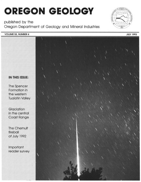
Cover photo<br />
Rare-<strong>and</strong> lucky-photo <strong>of</strong> a fireball over <strong>Oregon</strong>: The<br />
Chemult fireball <strong>of</strong> <strong>July</strong> 27, 1992. Photo was taken by Scott<br />
McAfee from near Crater Lake Lodge. The fireball came out<br />
<strong>of</strong> the zenith, increasing in brightness. See related report by<br />
Pugh <strong>and</strong> McAfee on page 90.<br />
OIL AND GAS NEWS<br />
Drilling begins at Mist Gas Field<br />
Nahama <strong>and</strong> Weagant Energy <strong>of</strong> Bakersfield, California, began<br />
drilling for natural gas at the Mist Gas Field, Columbia County,<br />
during May. The first well drilled was the Longview Fibre l2A-33-<br />
75, located in sec. 33, T. 7 N., R. 5 W, Columbia County. The well<br />
was drilled to a total depth <strong>of</strong> 2,475 ft <strong>and</strong> is currently suspended.<br />
The second well <strong>of</strong> the multi-well program is the Longview Fibre<br />
12B-35-65, located in sec. 35, T. 6 N., R. 5 W, Columbia County,<br />
where drilling operations are underway.<br />
NWPA elects <strong>of</strong>ficers, announces symposium<br />
At its monthly meeting on May 14, the Northwest Petroleum<br />
Association (NWPA) announced the newly elected <strong>of</strong>ficers <strong>and</strong><br />
directors for <strong>1993</strong>-94: President, Nancy Ketrenos; Vice president,<br />
Bert Mueller; Secretary, Dick Bowen; <strong>and</strong> Treasurer, Dan Wermiel.<br />
The new directors are John Taylor (western Washington), Harry<br />
Jamison (eastern <strong>Oregon</strong>lWashington), Jeff Pennick (L<strong>and</strong>), Bill<br />
Holmes (Legal), <strong>and</strong> Bob Deacon <strong>and</strong> Lise Katterman (at large).<br />
The association's 10th annual symposium will be held September<br />
26-28, <strong>1993</strong>, at the Inn <strong>of</strong> the Seventh Mountain in Bend, <strong>Oregon</strong>.<br />
Theme <strong>of</strong> the symposium will be "Earth Resources <strong>and</strong> the Pacific<br />
Northwest." The technical session will include papers on oil <strong>and</strong> gas<br />
play assessment, minerals, geothermal resources, coastal tectonostratigraphy,<br />
the Paleogene Willamette Basin, coal-bed methane, <strong>and</strong><br />
gas transmission activity. A field trip will be conducted in the<br />
Bend-Newberry National Volcanic Monument area <strong>and</strong> will highlight<br />
the geothermal potential <strong>and</strong> volcanology <strong>of</strong> central <strong>Oregon</strong>.<br />
The NWPA meets for monthly luncheon programs <strong>and</strong> an annual<br />
symposium. For details on the meetings <strong>and</strong> the symposium, contact<br />
the NWPA, P.O. Box 6679, Portl<strong>and</strong>, OR 97228-6679.<br />
Recent permits<br />
Status,<br />
Permit Operator, well, proposed total<br />
no. API number Location depth (ft)<br />
485 Carlxlll Energy IntI. SWY4 sec. 28 Application;<br />
JCLC Menasha 28-1 T. 26 S., R. 13 W. 1,650.<br />
36-011-axJ25<br />
Coos County<br />
486 Carbon Energy inti. SWY 4 sec. 32 Application;<br />
WNS Menasha 32-1 T. 26 S., R. 13 W. 1,600.<br />
36-0 )1-axJ26 Coos County<br />
487 Carlxlll Energy inti. SEY4 sec. 7 Application;<br />
Coos County Forest 7-1 T. 27 S., R. 13 W. 4,250.<br />
36-011-axJ27 Coos County D<br />
Grants Pass <strong>of</strong>fers video viewing<br />
The Grants Pass field <strong>of</strong>fice <strong>of</strong> the <strong>Oregon</strong> <strong>Department</strong> <strong>of</strong> <strong>Geology</strong><br />
<strong>and</strong> <strong>Mineral</strong> <strong>Industries</strong> (DOG AMI) <strong>of</strong>fers a collection <strong>of</strong> more<br />
than 60 videotapes to visitors for in-<strong>of</strong>fice viewing.<br />
The collection includes (I) programs for introductory study <strong>of</strong><br />
various geologic disciplines <strong>and</strong> the geologic processes those disciplines<br />
deal with, (2) presentations <strong>of</strong> the geology <strong>of</strong> particular<br />
localities, (3) descriptions <strong>of</strong> mines <strong>and</strong> mining operations, (4)<br />
descriptions <strong>of</strong> scenic geology <strong>and</strong> natural history, <strong>and</strong> (5) a program<br />
set for science teachers, presenting ideas, suggestions, <strong>and</strong> examples<br />
for classroom activities.<br />
The videotapes can be viewed at the DOGAMI Grants Pass field<br />
<strong>of</strong>fice Monday through Friday from I :00 to 5 :00 p.m. Address <strong>and</strong><br />
phone number are listed in the left-h<strong>and</strong> column on this page.<br />
Interested persons should contact the <strong>of</strong>fice for further information<br />
or for viewing appointments. D<br />
74<br />
OREGON GEOLOGY, VOLUME 55, NUMBER 4, JULY <strong>1993</strong>
Lith<strong>of</strong>acies <strong>and</strong> depositional environment <strong>of</strong> the Spencer<br />
Formation, western Tualatin Valley, <strong>Oregon</strong><br />
by Robert O. Van Atta <strong>and</strong> Richard E. Thoms, <strong>Department</strong> <strong>of</strong> <strong>Geology</strong>, Portl<strong>and</strong> State Universit}; Portl<strong>and</strong>, <strong>Oregon</strong> 97207<br />
ABSTRACT<br />
The Spencer Formation is a prime natural gas target in the<br />
Willamette Valley <strong>of</strong> western <strong>Oregon</strong>. It is coeval with the Cowlitz<br />
Formation from which gas is produced in the Mist Gas Field <strong>of</strong><br />
northwestern <strong>Oregon</strong>. Like the Cowlitz Formation, it includes a<br />
clean arkosic s<strong>and</strong> that is nearly 300 m thick in the Humble Oil Miller<br />
No.1 test hole near Albany, <strong>Oregon</strong>. This paper is based upon<br />
detailed studies <strong>of</strong> both cores <strong>and</strong> excellent surface outcrops in the<br />
western Tualatin Valley <strong>of</strong> northwestern <strong>Oregon</strong>. In this area, the<br />
most northerly occurrence <strong>of</strong> the Spencer Formation, it overlies the<br />
Yamhill Formation, which is mostly carbonaceous mudstone, with<br />
apparent conformity <strong>and</strong> is overlain by the Pittsburg Bluff Formation.<br />
The Spencer Formation can be informally divided into two<br />
members: (I) a lower, highly micaceous s<strong>and</strong>stone (62 m), <strong>and</strong> (2)<br />
an upper member that is micaceous siltstone <strong>and</strong> mudstone (308--400<br />
m). Locally, the lower member includes a very permeable s<strong>and</strong>stone<br />
that is lithologically indistinguishable from the gas-producing unit<br />
known as the "Clark <strong>and</strong> Wilson s<strong>and</strong>") <strong>of</strong> the Mist Field.<br />
Diagenesis <strong>of</strong> the Spencer Formation in the area <strong>of</strong> this study was<br />
limited to production <strong>of</strong> some chlorite, smectite, <strong>and</strong> mixed-layer<br />
smectite/illite. Percentages <strong>of</strong> the authigenic clays are greater in the<br />
upper part <strong>of</strong> the lower member <strong>and</strong> in the upper member, reflecting<br />
a somewhat greater content <strong>of</strong> volcanic detritus. Vitrinite reflectance<br />
<strong>of</strong> 0.22 indicates a low degree <strong>of</strong> thermal maturity.<br />
Depositional environments represented in the Spencer range<br />
from outer- to mid-neritic (lower part, lower member) to shallow<br />
neritic, nearshore, <strong>and</strong> lagoonal (upper part, lower member) to<br />
mid-neritic to upper bathyal depths (upper member).<br />
Based on s<strong>and</strong>stone framework grain modal composition, the<br />
provenance <strong>of</strong> the Spencer Formation includes both proximal volcanic<br />
rocks derived from the east <strong>and</strong> distal plutonic as well as<br />
medium- to high-grade metamorphic rocks probably derived from<br />
the region <strong>of</strong> the present-day northern Cascade Range <strong>and</strong> the<br />
northern Rocky Mountains.<br />
INTRODUCTION<br />
The earliest recorded hydrocarbon exploration activity in the<br />
Willamette Valley was in 1934-35, when three wells were drilled in<br />
Marion, Benton, <strong>and</strong> Linn Counties. No other drilling activity was<br />
recorded until 1957. From 1957 to 1981, 34 additional wells were<br />
drilled to test the Spencer Formation in Benton, Linn, Marion, <strong>and</strong><br />
Polk Counties (Baker, 1988).<br />
The Spencer Formation is correlative to the productive Cowlitz<br />
Formation "Clark <strong>and</strong> Wilson s<strong>and</strong>" (Bruer <strong>and</strong> others, 1984) in the<br />
Mist Gas Field, upper Nehalem River basin, northwestern <strong>Oregon</strong><br />
(Figure I), <strong>and</strong> throughout this paper comparisons are made between<br />
the arkosic s<strong>and</strong>stone in the Spencer Formation in the western Tualatin<br />
Valley <strong>and</strong> the arkosic "Clark <strong>and</strong> Wilson s<strong>and</strong>stone" <strong>of</strong> the<br />
Cowlitz Formation. The Spencer Formation is considered a potential<br />
reservoir for natural gas because <strong>of</strong> high permeability <strong>and</strong> porosity in<br />
a s<strong>and</strong>stone member, "Spencer s<strong>and</strong>" <strong>of</strong> Bruer <strong>and</strong> others (1984), <strong>and</strong><br />
there have been gas shows where it has been penetrated in the northern<br />
Willamette Valley. Thus, much <strong>of</strong> the recent exploration effort in the<br />
Willamette Valley has concentrated on the Spencer Formation.<br />
One small gas discovery occurred in the Spencer Formation in<br />
1981 at the American Quasar Hickey 9-12 well in Linn County.<br />
Production lasted for five months (Olmstead, 1989) <strong>and</strong> was ab<strong>and</strong>oned<br />
because production volume <strong>of</strong> gas became subcommercial.<br />
To date, no economic gas accumulations have been found.<br />
.0-<br />
N<br />
,Q"f.<br />
western'~oS'<br />
Tualatin l\J\~~<br />
VaHey "i' \ ,~.£.<br />
k., \ "'1\ Portl<strong>and</strong><br />
t\~<br />
~'i;l~t1~OrValtis<br />
,.<br />
Salem<br />
:... ~~ Eugene<br />
:.'<br />
WASHINGTON<br />
River<br />
OREGON<br />
Figure 1. Sketch map <strong>of</strong> northwestern <strong>Oregon</strong>. Areas discussed<br />
in text are indicated by stippled pattern.<br />
Data presented in this paper were obtained during a detailed study<br />
<strong>of</strong> the stratigraphy <strong>and</strong> paleontology <strong>of</strong> Paleogene rocks <strong>of</strong> the<br />
western Tualatin Valley conducted by the authors <strong>and</strong> by David<br />
Taylor, a visiting researcher at Portl<strong>and</strong> State University. Other<br />
sources <strong>of</strong> data not obtained in this study are cited where necessary.<br />
Paleoecologic interpretations proposed in this paper are based<br />
upon the following sources: Abbot (1954), Keen (1960), Keen <strong>and</strong><br />
Coan (1974), <strong>and</strong> Moore (1976) for mollusks; Ingle (1980) <strong>and</strong><br />
McKeel (1984) for the foraminifers; <strong>and</strong> Frey (1975) for trace<br />
fossils.<br />
Purpose<br />
The purpose <strong>of</strong> this paper is to present the results <strong>of</strong> a detailed<br />
study <strong>of</strong> the Spencer Formation in the northernmost part <strong>of</strong> its<br />
outcrop extent in an effort to determine its environment <strong>of</strong> deposition,<br />
provenance, <strong>and</strong> correlation to that <strong>of</strong> the arkosic s<strong>and</strong>stone <strong>of</strong><br />
the Cowlitz Formation in the region <strong>of</strong> the Mist Gas Field 50 km to<br />
the north. The western Tualatin Valley area affords a nearly complete<br />
stratigraphic section <strong>of</strong> the Spencer Formation. Additionally, relatively<br />
unweathered cores from the lower member <strong>of</strong> the formation<br />
provide the opportunity for petrologic comparison with generally<br />
weathered surface samples.<br />
Previous work<br />
Schlicker (1962) first demonstrated that s<strong>and</strong>stone above the<br />
Yamhill Formation in the western Tualatin Valley is correlative to<br />
the Spencer Formation. McWilliams (1968) includes the Yamhill<br />
Gales Creek area in his study <strong>of</strong> paleogene lithostratigraphy <strong>and</strong><br />
biostratigraphy <strong>of</strong> west-central <strong>Oregon</strong>.<br />
OREGON GEOLOGY, VOLUME 55, NUMBER 4, JULY <strong>1993</strong><br />
75
R4W - T1S<br />
LEGEND:<br />
8<br />
Contact " ..---... Alluvium<br />
Strike <strong>and</strong><br />
Pittsburg Bluff Fm.<br />
dip <strong>of</strong> beds<br />
Inferred fault, ../<br />
dotted where ,/<br />
concealed ,/<br />
ITs0 Spencer Fm.,<br />
~ upper member<br />
~ Spencer Fm.,<br />
t.....:.::-.J lower member<br />
~Yamhill Fm.<br />
O .... =~~05· ",,5;;;;;;;;;;;;=="",1.0 MI LE<br />
SCALE:<br />
Ty<br />
Base rna from USGS 7.5 min. Quad. Gaston sheet, 1956<br />
Figure 2. Geologic map <strong>of</strong> the Scoggins Valley area, Washington County, <strong>Oregon</strong>.<br />
AI-Azzaby (1980) made a detailed study <strong>of</strong> the sedimentology<br />
<strong>and</strong> stratigraphy <strong>of</strong> the Spencer Formation in the western Tualatin<br />
Valley. He described two informal members <strong>of</strong> the Spencer Formation<br />
in the western Tualatin Valley area, a lower arkosic s<strong>and</strong>stone<br />
<strong>and</strong> an upper silty s<strong>and</strong>stone <strong>and</strong> mudstone that in this paper are<br />
combined in a lower member. The upper member in this paper is the<br />
mudstone that AI-Azzaby called "Stimson Mill beds."<br />
Cunderla in 1986 completed a study <strong>of</strong> stratigraphic <strong>and</strong> petrologic<br />
trends within the Spencer Formation, including chemistry <strong>and</strong><br />
diagenesis, from Corvallis to Henry Hagg Lake. The "lower <strong>and</strong><br />
upper members" (infonnal) <strong>of</strong> his study are equivalent to the lower<br />
part <strong>and</strong> upper part, respectively, <strong>of</strong> the lower member (informal)<br />
distinguished in this report.<br />
The most recent study <strong>of</strong> the Spencer Fonnation is that <strong>of</strong> Baker<br />
(1988). Her work was concentrated in the west-central Willamette<br />
Valley <strong>and</strong> focused on stratigraphy <strong>and</strong> depositional environments<br />
that were determined from both surface <strong>and</strong> subsurface data.<br />
Regional stratigraphic relations<br />
In Washington State, the Spencer Fonnation is correlative to the<br />
Skookumchuck, Spiketon, <strong>and</strong> Renton Formations <strong>of</strong> the Puget<br />
Group <strong>and</strong> the younger part <strong>of</strong> the s<strong>and</strong>stone <strong>of</strong> Scow Bay in western<br />
Washington.<br />
In <strong>Oregon</strong>, the Spencer Formation can be correlated with the<br />
upper middle <strong>and</strong> upper members <strong>of</strong> the Coaledo Fonnation in the<br />
southern Coast Range <strong>of</strong> <strong>Oregon</strong> <strong>and</strong>, in the central Coast Range,<br />
with siltstone <strong>and</strong> volcanic rocks <strong>of</strong> the Nestucca Formation <strong>and</strong><br />
Yachats Basalt.<br />
Bruer <strong>and</strong> others (1984) consider the Spencer Fonnation to be<br />
coeval <strong>and</strong> continuous with the Cowlitz Formation <strong>of</strong> northwestern<br />
<strong>Oregon</strong>, although nowhere can the Spencer Formation be mapped<br />
from the western Tualatin Valley to the Cowlitz Formation in the<br />
upper Nehalem River basin, largely because <strong>of</strong> <strong>of</strong>fset along the<br />
Gales Creek fault (Van Atta, unpublished mapping, 1985; Figure<br />
I). Bruer <strong>and</strong> others also regard permeable arkosic s<strong>and</strong>stone in the<br />
Spencer Formation as coeval with the "Clark <strong>and</strong> Wilson s<strong>and</strong>" <strong>of</strong><br />
the Cowlitz Formation.<br />
The middle to lower upper Eocene (Narizian) Spencer Fonnation,<br />
named by Turner (1938), crops out in a generally narrow, somewhat<br />
sinuous b<strong>and</strong> that trends north-south in western <strong>Oregon</strong> (Figure I).<br />
The type locality is 16 km southwest <strong>of</strong> Eugene, in the vicinity <strong>of</strong><br />
Spencer <strong>and</strong> Coyote Creeks, where the unit is about 77 m thick.<br />
In the southern part <strong>of</strong> the outcrop belt (Drain to Eugene), the<br />
Spencer Formation unconformably overlies either the Tyee Formation<br />
or the Lorane Shale <strong>and</strong> is conformably overlain by the nonmarine<br />
Fisher Formation (Hoover, 1963; G<strong>and</strong>era, 1977). In the central<br />
area (Monroe to Salem), the Spencer Formation is underlain unconfonnably<br />
by either the mid-Eocene Tyee Fonnation (south <strong>of</strong> Corvallis)<br />
or the lower upper Eocene Yamhill Formation (Corvallis <strong>and</strong><br />
Albany), depending upon stratigraphic assignment <strong>of</strong> a thick s<strong>and</strong>stone<br />
lens ("Miller s<strong>and</strong>," informal; Bruer <strong>and</strong> others, 1984) lying<br />
between the Spencer <strong>and</strong> Tyee Fonnations to either the Yamhill or<br />
Spencer Fonnation. In the subsurface, in the eastern <strong>and</strong> southern<br />
parts <strong>of</strong> the central Willamette Valley, south <strong>of</strong> Corvallis, the Spencer<br />
is underlain by either mudstone, volcaniclastic rocks, or basaltic<br />
volcanic rocks <strong>of</strong> the Yamhill Fonnation (Baker, 1988).<br />
In the eastern <strong>and</strong> southern parts <strong>of</strong> the central Willamette Valley,<br />
northwest <strong>of</strong> Eugene (Figure I), the upper member (informal) <strong>of</strong> the<br />
Spencer is intercalated with basaltic volcanic rocks that Baker<br />
(\ 988) has termed "eastern Willamette volcanics" (informal). It is<br />
76<br />
OREGON GEOLOGY, VOLUME 55, NUMBER 4, JULY <strong>1993</strong>
LEGEND:<br />
r =.-.-.-.--~<br />
~:;:=:;=:::.:..:;:;:~ .~<br />
"-" -'----'_0'<br />
~.::.~ =-=~-= -==::: ~ =-""1<br />
COVERED<br />
2000 ft.<br />
Mudstone<br />
Siltstone<br />
S<strong>and</strong>stone<br />
Macr<strong>of</strong>ossils<br />
III<br />
c:<br />
COVERED<br />
upper member<br />
Siltstone, mudstone, s<strong>and</strong>stone, conglomerate: Medium to dark<br />
gray, weathering to orange- or yellow-brown; feldspathic siltstone<br />
<strong>and</strong> mudstone with minor micaceous, carbonaceous, feldspathic<br />
volcanic litharenite to lithic arkose. Minor s<strong>and</strong>y pebble<br />
conglomerate lenses. Laminated to cross-laminated or massive.<br />
Shelly macr<strong>of</strong>auna sparse. Lower contact <strong>of</strong> member conformable.<br />
...<br />
w<br />
W<br />
_LL<br />
lower member<br />
S<strong>and</strong>stone (80% <strong>of</strong> section), siltstone <strong>and</strong> conglomerate (each 10%<br />
<strong>of</strong> section): Light to medium gray, weathering to orange- or<br />
yellow-brown: highly micaceous, carbonaceous, occasionally pumiceous,<br />
glauconitic; poorly to moderately sorted. S<strong>and</strong>stone is<br />
lithic arkose to feldspathic litharenite; silty, very fine- to medium-grained.<br />
Minor buff colored arkose with high porosity, similar<br />
to the "Clark <strong>and</strong> Wilson S<strong>and</strong>". Most <strong>of</strong> section thoroughly<br />
bioturbated, 10-15% <strong>of</strong> section laminated <strong>and</strong> ripple cross-laminated.<br />
Shelly macr<strong>of</strong>auna common. Lower contact <strong>of</strong> member conformable.<br />
L- See text for differentiation <strong>of</strong> lower <strong>and</strong> upper parts <strong>of</strong> member.<br />
Figure 3. Stratigraphic column for Scoggins Valley, to the east <strong>and</strong> along north side <strong>of</strong> Henry Hagg Lake, Washington County, <strong>Oregon</strong>.<br />
overlain unconformably in the central area by the uppermost upper<br />
Eocene to middle Oligocene Eugene Formation.<br />
In the western Tualatin Valley from Yamhill, <strong>Oregon</strong>, to the<br />
Gales Creek fault, the Spencer Formation overlies the Yamhill<br />
Formation with apparent unconformity (AI-Azzaby, 1980; Cunderla,<br />
1986), although in the vicinity <strong>of</strong> Hagg Lake, the Spencer<br />
appears conformable over the Yamhill (Van Alta, unpublished<br />
mapping, 1985).<br />
The thickness <strong>of</strong> the Spencer Formation is quite variable throughout<br />
its extent. From south to north, its thickness is 45-145 m just<br />
east <strong>of</strong> Drain (Hoover, 1963), 620--840 m north <strong>and</strong> south <strong>of</strong> Eugene<br />
(G<strong>and</strong>era, 1977), 1,385 m near Corvallis (Vokes <strong>and</strong> others, 1954;<br />
Baldwin <strong>and</strong> others, 1955), <strong>and</strong> about 615 m in the northernmost<br />
outcrop area (Figure I). Baker (1988) believes, however, that the<br />
near-doubled thickness in the central area (Corvallis) may be the<br />
result <strong>of</strong> uncertainty concerning the age <strong>of</strong> the "Miller s<strong>and</strong>" (informal;<br />
Bruer <strong>and</strong> others, 1984), as noted above.<br />
G<strong>and</strong>era (1977) informally defined two members <strong>of</strong> the Spencer<br />
Formation in its type locality. North <strong>of</strong> the type locality, Baker (1988)<br />
finds that the Spencer Formation consists <strong>of</strong> two members (informal),<br />
traceable from the Corvallis area northward to the western Tualatin<br />
Valley: a lower member that consists <strong>of</strong> micaceous arkosic silty<br />
s<strong>and</strong>stone <strong>and</strong> siltstone <strong>and</strong> an upper member that is arkosic to lithic<br />
arkosic s<strong>and</strong>stone <strong>and</strong> mudstone. From the Corvallis area southward<br />
to the type locality, it does not appear possible to separate the<br />
formation into mappable members (Cunderla, 1986; Baker, 1988).<br />
Baker (1988) found that the lower s<strong>and</strong>stone-rich part <strong>of</strong> the<br />
Spencer Formation in the central area can be divided into a lowermost<br />
more arkosic part, <strong>and</strong> an upper part that is more lithic with<br />
volcanic rock fragments <strong>and</strong> with plagioclase feldspar more abundant<br />
than potassium feldspar. The lower member is more lithic<br />
(volcanic) in both lower <strong>and</strong> upper parts south <strong>of</strong> Corvallis as<br />
compared to its composition to the north.<br />
The informal members <strong>of</strong> the Spencer Formation described in<br />
the literature mayor may not be traceable throughout its occurrence<br />
in western <strong>Oregon</strong>, <strong>and</strong> any formal proposal to divide the Spencer<br />
into an upper <strong>and</strong> a lower member must await further work.<br />
METHODS<br />
Samples for petrographic study were collected from surface<br />
outcrops exposed in Scoggins Valley (Figure 2) <strong>and</strong> from shallow<br />
cores (maximum 77-m depth) that had been taken in the 1970s from<br />
these same formations in conjunction with dam-site foundation<br />
studies conducted by the U.S. Bureau <strong>of</strong> Reclamation. The cores<br />
were logged for detailed description <strong>of</strong> primary sedimentary structures<br />
<strong>and</strong> occurrence <strong>of</strong> fossils. Eight cores in the Spencer Formation<br />
(maximum thicknesses 37 m in lower part <strong>of</strong> lower member, 54 m<br />
in upper part <strong>of</strong> lower member) were studied <strong>and</strong> sampled. In<br />
addition, five samples were taken from core <strong>of</strong> the "Clark <strong>and</strong> Wilson<br />
s<strong>and</strong>," Cowlitz Formation (Texaco Clark <strong>and</strong> Wilson 6-1 well,<br />
Columbia County, <strong>Oregon</strong>, at 943-952 m).<br />
Textural analyses for grain size distribution in the s<strong>and</strong>-size<br />
OREGON GEOLOGY, VOLUME 55, NUMBER 4, JULY <strong>1993</strong><br />
77
fraction (-1.0 to +4.0 phi) were done for 56 core samples (28 <strong>and</strong> 23<br />
samples from the Spencer Formation, lower member, lower part <strong>and</strong><br />
upper part, respectively; 5 from "Clark <strong>and</strong> Wilson s<strong>and</strong>"). S<strong>and</strong>-siltclay<br />
ratios were also determined for 66 samples <strong>of</strong> the lower member<br />
<strong>of</strong> the Spencer Formation (38 from lower part; 28 from upper part).<br />
The size parameters <strong>of</strong> s<strong>and</strong>stone samples were determined with<br />
a 2-m settling tube. The output <strong>of</strong> the tube's strain gauge was fed to<br />
a programmed microprocessor coupled with a programmable calculator.<br />
The calculator was programmed to read out raw <strong>and</strong> smoothed<br />
data tables <strong>and</strong> to print histograms. Size-frequency data were used<br />
to calculate the coarsest I percent, phi median, mean, st<strong>and</strong>ard<br />
deviation, <strong>and</strong> skewness according to the size parameters <strong>of</strong> Inman<br />
(1952) <strong>and</strong> Folk <strong>and</strong> Ward (1957). Moment measures were calculated<br />
by means <strong>of</strong> a computer program created at the School <strong>of</strong><br />
Oceanography at <strong>Oregon</strong> State University.<br />
Thin sections from core (24 from Spencer Formation; 4 from<br />
"Clark <strong>and</strong> Wilson s<strong>and</strong>"), impregnated with colored epoxy, were<br />
used to determine <strong>and</strong> to estimate texture, including pore types,<br />
shapes, <strong>and</strong> distribution. Detrital modes were determined according<br />
to the procedures <strong>of</strong> Dickinson <strong>and</strong> Suzek (1979). In addition,<br />
porosity <strong>and</strong> diagenetic effects were examined in 10 samples <strong>of</strong> the<br />
lower member <strong>of</strong> the Spencer Formation by scanning electron mi-<br />
Table I. Size parameters <strong>of</strong> -1 to 5 phi fraction, Spencer <strong>and</strong> Cowlitz Formations<br />
Coarsest 1 percent<br />
(phi)<br />
Median size<br />
(phi)<br />
Sorting<br />
(aD)<br />
Skewness<br />
(phi)<br />
Unit, location, sample type Average Range Average Range Average Range Average Range<br />
Spencer Formation, lower member<br />
(core samples)<br />
Upper part, Patton <strong>and</strong> Scoggins Valleys<br />
Lower part, Scoggins Valley<br />
1.59<br />
2.43<br />
0.98-2.97<br />
2.97<br />
2.80<br />
1.94-3.60<br />
2.63-3.33<br />
0.58<br />
0.39<br />
0.35-0.84<br />
0.11-0.59<br />
0.45 -0.17-0.72<br />
0.38 -0.62-1.97<br />
Number<br />
<strong>of</strong><br />
samples<br />
16<br />
28<br />
Spencer Formation, western Thalatin Valley<br />
(AI-Azzaby, 1980; surface samples)<br />
Upper part, lower member<br />
Lower part, lower member<br />
Stimson Mill beds (=upper member,<br />
this report)<br />
3.72<br />
4.09<br />
4.16<br />
2.71-4.59<br />
3.36-4.51<br />
3.45-5.46<br />
1.91<br />
1.84<br />
2.30<br />
1.29-2.59<br />
1.28-2.42<br />
1.81-2.74<br />
0.74<br />
0.72<br />
0.69<br />
0.62-0.88<br />
0.57-0.82<br />
0.65-0.74<br />
9<br />
6<br />
4<br />
Cowlitz Formation, upper Nehalem River basin<br />
Arkosic s<strong>and</strong>stone<br />
(surface samples, Van Atta, 1971)<br />
3.15<br />
2.50-3.70<br />
1.24<br />
0.73-1.99<br />
0.52<br />
0.28-0.74<br />
7<br />
Clark <strong>and</strong> Wilson s<strong>and</strong>, Texaco Clark<br />
<strong>and</strong> Wilson 6-1 well (core samples)<br />
2.82<br />
2.71-3.16<br />
2.95<br />
2.78-3.15<br />
0.50<br />
0.44-0.60<br />
0.14 -0.16-0.38<br />
5<br />
Table 2. Composition averages <strong>of</strong> s<strong>and</strong>stone <strong>of</strong> the Spencer <strong>and</strong> Cowlitz Formations, based on number <strong>of</strong> samples as indicated for each<br />
unit. Values in percent, except PIK ratio. Qm=monocrystalline quartz; Qp=polycrystalline quartz; F=feldspar; PIK=plagioclase!potash<br />
feldspar ratio; Lvm=lithic volcanic <strong>and</strong> metamorphic rockfragments; L=totallithic rock fragments<br />
Unit, location, number <strong>and</strong> type <strong>of</strong> samples Qm Qp F PIK Lvm L Mica<br />
Spencer Formation,lower member<br />
Upper part, Patton <strong>and</strong> Scoggins Valleys, 19.2 4.7 34.0 1.3 7.4 13.9 4.5<br />
4 core samples<br />
Lower part, Scoggins Dam, south abutment, 8.9 1.5 43.0 0.5 9.4 9.6 6.8<br />
3 core samples<br />
Modal composition:<br />
QFL<br />
Q F L<br />
35<br />
16<br />
49<br />
68<br />
16<br />
16<br />
Modal composition:<br />
QmPK<br />
Qm<br />
P<br />
36 35<br />
17<br />
20<br />
K<br />
29<br />
63<br />
Spencer Formation, western Thalatin Valley<br />
(from AI-Azzaby, 1980)<br />
12 surface samples; equal to upper part,<br />
lower member, this report<br />
30.4<br />
5.6 56.2<br />
1.6<br />
6.4 6.5 4.5<br />
36<br />
56<br />
8<br />
35<br />
40<br />
25<br />
6 surface samples; equal to lower part,<br />
lower member, this report<br />
24.2<br />
3.9 61.0<br />
0.9<br />
9.4 9.5 6.7<br />
28<br />
61<br />
11<br />
28<br />
35<br />
37<br />
Cowlitz Formation, upper Nehalem River basin<br />
Texaco Clark <strong>and</strong> Wilson 6-1 well, 16.9<br />
4 core samples<br />
2.2 46.0<br />
0.7<br />
1.6 2.5 10.2<br />
27<br />
67<br />
6<br />
24<br />
25<br />
51<br />
Cowlitz Formation, previous work<br />
Van Atta, 1971, II samples<br />
40.0<br />
2.3 38.2<br />
1.1<br />
2.0 8.1<br />
8.2<br />
46<br />
44<br />
10<br />
51<br />
26<br />
23<br />
Timmons, 1981,6 samples<br />
14.3<br />
7.3 54.5<br />
0.7<br />
6.0 16.2<br />
6.6<br />
26<br />
67<br />
7<br />
21<br />
33<br />
46<br />
Jackson, 1983, 10 samples<br />
26.6<br />
1.7 41.2<br />
1.3<br />
2.8 4.9<br />
9.3<br />
38<br />
55<br />
7<br />
39<br />
34<br />
27<br />
78 OREGON GEOLOGY, VOLUME 55, NUMBER 4, JULY <strong>1993</strong>
croscopy (SEM). Percent porosity <strong>and</strong> permeability to air <strong>of</strong> five <strong>of</strong><br />
these samples were determined by Core Labs, Inc., Dallas, Texas.<br />
X-ray diffraction analysis <strong>of</strong> four samples (three from Spencer<br />
Formation, one from "Clark <strong>and</strong> Wilson s<strong>and</strong>") correlated clay<br />
mineralogy with the thin-section <strong>and</strong> SEM-petrographic studies.<br />
A geologic map <strong>of</strong> the study area in the vicinity <strong>of</strong> Henry Hagg<br />
Lake, western Tualatin Valley, is given in Figure 2. Figure 3 presents<br />
a stratigraphic section <strong>of</strong> the Spencer Formation compiled from<br />
surface data <strong>and</strong> subsurface information taken from cores. The<br />
balance <strong>of</strong> this paper will concern itself with this region <strong>of</strong> study.<br />
LITHOFACIES<br />
SAND<br />
o upper part<br />
• lower part<br />
Lower member<br />
Texture: The rocks <strong>of</strong> the lower part <strong>of</strong> the lower member <strong>of</strong> the<br />
Spencer Formation are classified mostly as silty s<strong>and</strong>stone or s<strong>and</strong>stone<br />
(Folk, 1974). The upper part <strong>of</strong> the lower member includes<br />
silty <strong>and</strong> muddy s<strong>and</strong>stone with some interbedded mudstone <strong>and</strong><br />
s<strong>and</strong>y siltstone (Figure 4). The upper part is sometimes pebbly with<br />
volcanic rock <strong>and</strong> quartzite clasts up to 12 mm in size. Both parts<br />
have angular mudstone clasts up to 6 mm in size.<br />
Compared to the upper part <strong>of</strong> the lower member, the lower part<br />
is somewhat finer <strong>and</strong> has a narrow range in mean grain size, is well<br />
sorted (st<strong>and</strong>ard deviation), <strong>and</strong> is strongly skewed (Table I <strong>and</strong><br />
Table 3. Comparison <strong>of</strong> lithology <strong>and</strong> trace fossils. upper <strong>and</strong><br />
lower parts <strong>of</strong> the lower member; Spencer Formation<br />
Primary structure<br />
Massive bedding (bioturbation)<br />
Laminae<br />
Indistinct laminae<br />
Cross-laminae<br />
Indistinct cross-laminae<br />
Ripple laminae<br />
Textural variants<br />
Pebbles<br />
Mudstone clasts<br />
Coarsening upward cycles<br />
Fining upward cycles<br />
Accessories<br />
Mica<br />
Pumice<br />
Traces/fossils<br />
Bioturbation<br />
Burrows<br />
Mollusk shell<br />
Articulated<br />
Disarticulated<br />
Broken<br />
Wood fragments<br />
Plant debris<br />
Carbon<br />
Carbon partings<br />
Lower part<br />
Common<br />
Present<br />
Present<br />
Present<br />
Present<br />
Present<br />
Common<br />
Common<br />
Abundant<br />
Common<br />
Abundant<br />
Common<br />
Present<br />
Common<br />
Common<br />
Present<br />
Abundant<br />
Common<br />
Common<br />
Upper part<br />
Present<br />
Common<br />
Present<br />
Present<br />
Present<br />
Common. basalt<br />
<strong>and</strong> mudstone<br />
Present<br />
Present<br />
Common<br />
Abundant<br />
Common<br />
Abundant<br />
Common<br />
Abundant<br />
Very abundant<br />
Flood<br />
Common<br />
Figure 4. S<strong>and</strong>-silt-clay ratio. Spencer Formation. lower member.<br />
Figure 5). Samples from the upper part show a much broader range<br />
<strong>of</strong> sorting <strong>and</strong> skewness, with one-third (nine) <strong>of</strong> the samples tested<br />
showing strong coarse (negative) skewness.<br />
The textural size parameters <strong>of</strong> the "Clark <strong>and</strong> Wilson s<strong>and</strong>" in<br />
the upper Nehalem River basin are comparable to those <strong>of</strong>the lower<br />
member <strong>of</strong> the Spencer Formation in the western Tualatin Valley.<br />
Samples from cores <strong>of</strong> the Texaco Clark <strong>and</strong> Wilson 6--1 well were<br />
taken at 943-952 m depth, <strong>and</strong> samples from other test holes were<br />
taken from about 100 m lesser depth in the "Clark <strong>and</strong> Wilson s<strong>and</strong>"<br />
that may be comparable to the upper part <strong>of</strong> the lower member <strong>of</strong><br />
the Spencer Formation (Table 1).<br />
Plots <strong>of</strong> the coarsest 1 percent (C) vs. the median size (M) in<br />
millimeters (Figure 6), produced with the method <strong>of</strong> Passega (1957),<br />
show that values for the lower part <strong>of</strong> the lower member <strong>of</strong> the<br />
Spencer Formation (28 samples) are tightly grouped. The plots all<br />
fall in the turbidity current field. This would indicate rather uniform<br />
processes <strong>of</strong> sediment transport <strong>and</strong> deposition. However, other<br />
evidence <strong>of</strong> turbidity current deposition in the lower part <strong>of</strong> the lower<br />
member (e.g., Bouma sequences) is absent. It is more likely that<br />
simple tracti ve currents (contour currents?) account for the uniformity<br />
<strong>of</strong> CM values. Plots <strong>of</strong> C vs. M values for core samples <strong>of</strong> "Clark<br />
<strong>and</strong> Wilson s<strong>and</strong>" from the Texaco Clark <strong>and</strong> Wilson 6-1 well show<br />
this s<strong>and</strong>stone to be like the lower part <strong>of</strong> the lower member <strong>of</strong> the<br />
Spencer Formation (Figure 6).<br />
In contrast, the upper part <strong>of</strong> the lower member <strong>of</strong> the Spencer<br />
Formation shows a coarser first percentile for most samples <strong>and</strong> a<br />
very wide deviation in plots <strong>of</strong> this versus the median size. Part <strong>of</strong><br />
the plot falls in the field typical <strong>of</strong> beach processes (Passega, 1957).<br />
Sedimentary features, lower part <strong>of</strong>lower member: The lower<br />
part <strong>of</strong> the lower member <strong>of</strong> the Spencer Formation in the Scoggins<br />
Valley section as exposed on the north side <strong>of</strong> Henry Hagg Lake<br />
(Figure 3) <strong>and</strong> in subsurface cores (Table 2) consists <strong>of</strong> about 25-30<br />
m <strong>of</strong> massive to faintly laminated, fine- to very fine grained, medium-gray<br />
to greenish-gray, highly micaceous, carbonaceous lithic<br />
arkose to feldspathic litharenite. Very thin (1.2-2.5 cm) pumiceous<br />
beds with reverse grading <strong>of</strong> pumice suggest an air fall combined<br />
with waterlaid sedimentation. Most beds are massive. Both coarsening<br />
upward <strong>and</strong> fining upward sequences can be seen. The lower part<br />
<strong>of</strong> the lower member <strong>of</strong> the Spencer Formation in the western<br />
Tualatin Valley is lithologically quite similar to the Spencer Formation<br />
to the south in its type locality near Eugene.<br />
OREGON GEOLOGY, VOLUME 55, NUMBER 4, JULY <strong>1993</strong><br />
79
Carbonized wood <strong>and</strong> plant debris are common. Mollusks,<br />
chiefly pelecypods, are represented by infrequent whole valves <strong>and</strong><br />
some articulated valves but mainly by common disarticulated <strong>and</strong><br />
broken valves. This strongly suggests a transported association.<br />
Primary structures observed are listed by unit in Table 3.<br />
Sedimentary features, upper part <strong>of</strong> lower member: Cores<br />
taken in Scoggins Valley <strong>and</strong> in Patton Valley, immediately south <strong>of</strong><br />
Scoggins Valley (Table 2) yielded samples <strong>of</strong> the upper part <strong>of</strong> the<br />
lower member. The rock consists <strong>of</strong> 0.5- to 9-m-thick beds <strong>of</strong><br />
light-gray to medium-gray (weathers orangish to yellowish brown,<br />
especially where it is glauconitic) silty s<strong>and</strong>stone, pebbly s<strong>and</strong>stone,<br />
<strong>and</strong> s<strong>and</strong>y siltstone. In composition, it is a highly micaceous, carbonaceous,<br />
glauconitic lithic to feldspathic litharenite with angular to<br />
subangular grains. Laminae are composed almost entirely <strong>of</strong> biotite<br />
with minor muscovite.<br />
a<br />
3.5<br />
3.0<br />
2.5<br />
2.0<br />
• •<br />
••• •<br />
•<br />
o upper part<br />
• lower part<br />
(J "Clark <strong>and</strong> Wilson S<strong>and</strong>"<br />
(Tex, C&W #6-1)<br />
,10-- ............<br />
Creamy gray arkose with high porosity <strong>and</strong> permeability composes<br />
a part <strong>of</strong> the section. This "clean" « 5 percent clay) arkose<br />
appears only as two 0.3-m beds in cores in the Scoggins section, on<br />
the north side <strong>of</strong> Henry Hagg Lake, but thickens southward, with<br />
beds <strong>of</strong> 9 m thickness in cores in Patton Valley <strong>and</strong> beds <strong>of</strong> several<br />
tens <strong>of</strong> meters thickness in hills 0.8 km south <strong>of</strong> Patton Valley. The<br />
upper part <strong>of</strong> the lower member differs from the Spencer in the<br />
Corvallis area in that it includes these interbeds <strong>of</strong> "cleaner," highly<br />
feldspathic s<strong>and</strong>stone, very similar to the "Clark <strong>and</strong> Wilson s<strong>and</strong>"<br />
<strong>of</strong> the Mist area.<br />
Primary structures seen in the upper part <strong>of</strong> the lower member<br />
(Table 3) include laminations <strong>and</strong> ripple cross-laminations. Massive,<br />
bioturbated beds are few. Tubular burrows (counter to bedding) are<br />
more common here than in the lower part, consisting <strong>of</strong> two distinct<br />
sizes (4-5 mm <strong>and</strong> 15-25 mm in diameter). They frequently exhibit<br />
well-preserved linings <strong>of</strong> mica, mud, <strong>and</strong> green clay (glauconite?).<br />
I I --_- ____ _<br />
\\ 0<br />
---------<br />
o<br />
o<br />
\ 0<br />
\<br />
\<br />
\<br />
\<br />
\<br />
\<br />
\<br />
\<br />
',0<br />
----------<br />
_----- ----0\<br />
,<br />
° I /<br />
o /<br />
-----_..-//<br />
I<br />
I<br />
/<br />
I<br />
I<br />
I<br />
I<br />
I<br />
01<br />
1<br />
1<br />
I<br />
/<br />
I<br />
,<br />
,<br />
f<br />
I<br />
I<br />
I<br />
•<br />
1.5~------~------,_------,_------,_------,_------,_------~------~----~<br />
0.1 0.2 0.3<br />
0.5 0.6 0.7 0.8 0.9<br />
~ St<strong>and</strong>ard deviation<br />
b<br />
3.5<br />
3.0<br />
• •<br />
•<br />
/0'\<br />
I \<br />
I<br />
,<br />
•<br />
2.5<br />
2.0<br />
o upper part<br />
• lower part<br />
6 "Clark <strong>and</strong> Wilson S<strong>and</strong>"<br />
(Tex, C&W #6-1)<br />
1.5<br />
-1.2 -0.8 -0.4<br />
o 0.4<br />
9 Skewness<br />
0.8<br />
1.2 1.6 2.0<br />
Figure 5. Texture comparison between the lower member <strong>of</strong> the Spencer Formation, <strong>and</strong> the" Clark <strong>and</strong> Wilson s<strong>and</strong>, " <strong>of</strong> the Cowlitz Formation<br />
(Texaco Clark <strong>and</strong> Wilson 6-1 well), showing (a) mean phi (I\» size <strong>and</strong> phi st<strong>and</strong>ard deviation; (b) mean phi <strong>and</strong> phi skewness.<br />
80 OREGON GEOLOGY, VOLUME 55, NUMBER 4, JULY <strong>1993</strong>
Table 4. Permeability] <strong>and</strong> porosity2 in selected samples, lower member; Spencer Formation, western Tualatin Valle); <strong>and</strong> Cowlitz<br />
Formation, upper Nehalem River basin, <strong>Oregon</strong><br />
Pores<br />
Unit, Permeability Porosity Size S<strong>and</strong>-silt-clay<br />
sample number, depth (md) (%) Type 3 Shape Clay4<br />
(~) Distribution ratio<br />
Spencer Formation, lower member, upper part<br />
DH 105-0216,32 m 17.6* I(D) Polygonal 30-150 R<strong>and</strong>om<br />
DH 105-0217,33 m 0.1* I,M(S) Linear 2-3 Interlaminar 74-16-9<br />
(mica)<br />
DH 105-0219,50 m 167.0 26.3 I,M(D) Polygonal Clay in throat 1-3 R<strong>and</strong>om 79-13-8<br />
DH 103-0228, 30 m 1,500 28.8 I(D) Polygonal Little authigenic clay 50-100 R<strong>and</strong>om, 84-13-3<br />
irregular<br />
DH 103-0229,42 m 0.6 23.3 84-9-7<br />
DH 51-0285, 34 m 13.2* I(M) Polygonal, Smectite closes pore 5-10 R<strong>and</strong>om 72-18-1<br />
linear<br />
throats<br />
DH 48-0287, II m 1.0* M, F(I) Linear Clay bridges pores; 1-3 R<strong>and</strong>om<br />
throats closed<br />
Spencer Formation, lower member, lower part<br />
DH 6-0011, 4 m 8.0* Linear Smectite lining; pore 10-40 R<strong>and</strong>om 73-19-8<br />
throats closed<br />
DH 6-0016, 17 m 10.0 Linear Smectite lining; pore 5-10 R<strong>and</strong>om 66-22-12<br />
throats closed<br />
DH 12-0020, 12 m 1.0 I.M(F) Polygonal, 1-2 R<strong>and</strong>om 45-53-4<br />
linear<br />
DH 12-0022. 17 m 12.6* I (D) Polygonal, Smectite partly closes 20-70 R<strong>and</strong>om 82-14-4<br />
linear pore throats<br />
Cowlitz Formation, Clark <strong>and</strong> Wilson s<strong>and</strong><br />
Texaco Clark <strong>and</strong> 13.2* I (F) Polygonal, Smectite lining; pore 10-30 R<strong>and</strong>om<br />
Wilson 6-1, 0305 linear throats cl osed<br />
1 Permeability to air; clean, dry core segments. Core Laboratories, Inc. Values in millidarcies (md).<br />
2 Porosity: Boyle's Law detennination with helium. Core Laboratories, Inc. Values marked with * were determined in thin section.<br />
3 Pore types: I=intergranular; D=dissolution; M=microporosity; F=fractured; S=shrinkage.<br />
4 Clay determined by X-ray diffractometry.<br />
Table 5. Porosity <strong>and</strong> permeability <strong>of</strong> surface samples, Spencer<br />
Formation, according to Schlicker (1962)<br />
Permeability Porosity<br />
]'1;0. Location (md) (percent)<br />
SE corner sec. 20, T. IS., R. 4 W. 184 36<br />
2 SEl/4 sec. 32, T. I S .. R. 4 W. 202 32.2<br />
3 NEl/4 sec. 16, T. 2 S., R. 4 W. 1,130 31.7<br />
4 SE~ sec. 30, T. 3 S., R. 4 W. 812 41.3<br />
5 swv 4 NWV 4 sec. 30, T. 3 S., R. 3 W. 736 1.2<br />
6 NWV 4 sec. 24, T. 3 S., R. 4 W. 1,850 41.1<br />
7 NEll, sec. I, T. 3 S., R. 4 W. 2,200 40.7<br />
8 NWV 4 sec. IS, T. 2 S., R. 4 W. 4,510 41.5<br />
9 NEV, SEV 4 sec. 32, T. IS., R 4 W. 3,510 32.9<br />
Fossils include articulated <strong>and</strong> single valves <strong>and</strong> broken fragments<br />
<strong>of</strong> pelecypods. Rare gastropods are also found. Some mollusks,<br />
such as Solen, are found in living position. Pelecypods,<br />
including the genera Volsella, Solen, Nuculana, Pitar, Spisula, Venericardia,<br />
<strong>and</strong> Acila are more numerous than in the lower part. Some<br />
shell concentrations form coquinoid biostromes. The overall appearance<br />
is that <strong>of</strong> a transported association mixed with a few deeper<br />
water (at least subtidal) in situ forms.<br />
Carbonized plant debris is common in both parts <strong>of</strong> the lower<br />
member but can make up 5-10 percent <strong>of</strong> some beds in the upper<br />
part, where wood fragments up to 40 cm in length may be found.<br />
Toredo-bored wood is also found in the upper part. Wood fragments<br />
<strong>and</strong> carbonized plant debris appears to be detrital.<br />
According to AI-Azzaby (1980), thin (I-cm) layers <strong>of</strong> coal are<br />
very common in the upper part <strong>of</strong> the lower member <strong>of</strong> the Spencer<br />
Formation just south <strong>of</strong> Hagg Lake. It appears that this coal is<br />
detrital. A 30-cm-thick bed <strong>of</strong> coal is reported on the bank <strong>of</strong> a small<br />
creek (SWV, sec. 36, T. 2 S., R. 4 W,) just <strong>of</strong>f Woodl<strong>and</strong> Loop Road,<br />
about 6.6 km east <strong>of</strong> Yamhill, <strong>Oregon</strong>. This was worked as a coal<br />
prospect until 1907 (<strong>Oregon</strong> <strong>Department</strong> <strong>of</strong> <strong>Geology</strong> <strong>and</strong> <strong>Mineral</strong><br />
<strong>Industries</strong>, 1951). It is not known whether the coal is rooted or not,<br />
since it is not now possible to locate this coal bed.<br />
OREGON GEOLOGY, VOLUME 55, NUMBER 4, JULY <strong>1993</strong><br />
81
';'0<br />
....<br />
VI<br />
QI<br />
VI<br />
...<br />
'" o<br />
U<br />
10.0<br />
Outline areas show ty pical environments <strong>of</strong>:<br />
Rivers, tractive currents (I, I V, V)<br />
Turbidity currents (II, IVA, VIB,)<br />
Beaches (VII)<br />
1.0<br />
0.1<br />
I<br />
I<br />
I I<br />
,.....<br />
I~<br />
I<br />
./ //<br />
/~,~<br />
• r / .<br />
y<br />
0.01 0.1<br />
Median in mm<br />
o upper part<br />
• lower part<br />
C; "Clark <strong>and</strong> Wilson S<strong>and</strong>"<br />
(Tex, C&W #6-1)<br />
1.0<br />
Figure 6. CM diagram o/Spencer Formation, lower member; <strong>and</strong><br />
"Clark <strong>and</strong> Wilson s<strong>and</strong>" (Texaco Clark <strong>and</strong> Wilson 6-1 well).<br />
Clay mineralogy: The clay in the lower part <strong>of</strong> the lower member<br />
<strong>of</strong> the Spencer Formation includes mostly detrital smectite. A few<br />
percent, at most, is authigenic. Variable lesser percentages <strong>of</strong> kaolinite,<br />
chlorite, <strong>and</strong> mixed layer illite/smectite are also present; the<br />
chlorite appears to be mostly authigenic. In the upper part <strong>of</strong> the lower<br />
member, smectite makes up about 50 percent, kaolinite about 35<br />
percent, <strong>and</strong> chlorite about 15 percent <strong>of</strong> the clay present. As in the<br />
lower part <strong>of</strong> the lower member, a few percent <strong>of</strong> smectite <strong>and</strong> chlorite<br />
appears to be authigenic, while the illite/smectite is mostly authigenic.<br />
According to Cunderla (1986), mixed layer illite/smectite is more<br />
abundant in the upper part <strong>of</strong> the lower member <strong>of</strong> the Spencer<br />
Formation. This is similar to the clay mineralogy <strong>of</strong> the Cowlitz<br />
Formation in the upper Nehalem River basin (Van Atta, 1971).<br />
Samples <strong>of</strong> the "Clark <strong>and</strong> Wilson s<strong>and</strong>" analyzed for this study<br />
showed only smectite clay present.<br />
Throughout the Spencer Formation, the clay minerals are mostly<br />
detrital. Scanning electron microscopy reveals that, when smectite<br />
<strong>and</strong> chlorite are present, a small amount is authigenic on grain<br />
surfaces in pore spaces (Figure 7a). Samples with a high porosity<br />
but low permeability have more authigenic clay, which reduces pore<br />
sizes <strong>and</strong> blocks pore throats.<br />
Porosity <strong>and</strong> permeability: Porosity <strong>and</strong> permeability (PIP) in<br />
the Spencer Formation vary widely (Table 4). Values <strong>of</strong>23.3 percent<br />
<strong>and</strong> 0.6 millidarcies (md) (Sample 0229, DH 103) <strong>and</strong> 28.8 percent<br />
<strong>and</strong> 1,500 md (Sample 0228, DH 103), measured in core taken in a<br />
drill hole in Patton Valley, are typical. The s<strong>and</strong> content <strong>of</strong> these two<br />
rocks differs by only I percent, but the s<strong>and</strong> in the more permeable<br />
rock is coarser, <strong>and</strong> there is only about half as much clay in it as in<br />
the less permeable rock. Table 4 compares measured values <strong>of</strong> porosity<br />
<strong>and</strong> permeability together with clay present, description <strong>of</strong> pores,<br />
<strong>and</strong> s<strong>and</strong>/silt/clay ratios for both the Spencer Formation <strong>and</strong> the<br />
"Clark <strong>and</strong> Wilson s<strong>and</strong>" in the Texaco Clark <strong>and</strong> Wilson 6-1 well.<br />
The arkosic s<strong>and</strong>stone with the very high permeability (Sample<br />
0228, Patton Valley, Table 4) is very similar to an arkosic s<strong>and</strong> that<br />
makes up most <strong>of</strong> the section (about 400 m) in Williams Canyon,<br />
about 2.5 km south <strong>of</strong> Patton Valley. It appears that this permeable<br />
s<strong>and</strong>stone thins <strong>and</strong> thickens « 1 m to several tens <strong>of</strong> meters, at least)<br />
over a distance <strong>of</strong> about 16 km. The most probable interpretation<br />
would be that the permeable s<strong>and</strong>stone represents the filling <strong>of</strong> a<br />
major submarine channel. Since mud rocks <strong>of</strong> the overlying upper<br />
member <strong>of</strong> the Spencer Formation <strong>and</strong> underlying Yamhill Formation<br />
provide a good seal, such buildups <strong>of</strong> high-PIP s<strong>and</strong>stone in the<br />
Spencer could be excellent reservoirs .<br />
However, scanning electron microscopy (Figure 7) shows that<br />
even a small amount <strong>of</strong> additional clay, some <strong>of</strong> which appears to be<br />
authigenic, is effective in reducing pore throat size to cause a much<br />
lower permeability. An arkosic s<strong>and</strong>stone (Sample 0219) from a test<br />
hole in the upper part <strong>of</strong> the lower member <strong>of</strong> the Spencer Formation<br />
in Patton Valley has a fair porosity (26.3 percent), but authigenic<br />
smectite has reduced pore throat size so that permeability is only 167<br />
md (Table 4 <strong>and</strong> Figure 7b). Samples 0219 <strong>and</strong> 0228 have very similar<br />
s<strong>and</strong>/silt/clay ratios (79-13-8 <strong>and</strong> 84-13-3, respectively, Table 4) so<br />
that even a 5-percent difference in clay content is effective in drastically<br />
reducing permeability. Such differences in permeability in the<br />
Spencer s<strong>and</strong>stones appear to be the rule rather than the exception .<br />
Schlicker (1962) reported highly variable values <strong>of</strong> permeability<br />
for nine surface outcrop samples <strong>of</strong> Spencer Formation s<strong>and</strong>stone,<br />
as shown in Table 5.<br />
The friability <strong>of</strong> most surface outcrops <strong>of</strong> s<strong>and</strong>stone <strong>of</strong> the<br />
Spencer Formation makes it difficult to collect <strong>and</strong> transport undisturbed<br />
samples. Some <strong>of</strong> the extremely high porosity <strong>and</strong> permeability<br />
values reported by Schlicker could be due to the way in which<br />
samples were collected, although Schlicker (oral communication,<br />
1987) did not believe that this was the cause <strong>of</strong> the variability.<br />
Weathering <strong>and</strong> partial removal <strong>of</strong> fines by ground water percolation<br />
could also account for some <strong>of</strong> the exceptionally high permeabilities.<br />
Measurement <strong>of</strong> PIP in surface outcrops <strong>of</strong> Cowlitz Formation<br />
arkose in the upper Nehalem River basin, reported by Newton <strong>and</strong><br />
Van Atta (1976), show a range <strong>of</strong>30.9-36.2 percent <strong>and</strong> 31-823 md,<br />
respectively. Newton <strong>and</strong> Van Atta also reported porosity <strong>and</strong> permeability<br />
measurements <strong>of</strong> arkosic s<strong>and</strong>stone samples from the<br />
Texaco Clark <strong>and</strong> Wilson 6-1 well. These values show a wide<br />
variance (10-37.8 percent <strong>and</strong> 3-1,302 md).<br />
In summary, arkosic s<strong>and</strong>stone in the lower member <strong>of</strong> the<br />
Spencer Formation usually has a high porosity (20-30 percent), <strong>and</strong><br />
the permeability may range from very low to very high values,<br />
depending upon the amount <strong>of</strong> silt <strong>and</strong> detrital clay <strong>and</strong>/or the<br />
occurrence <strong>of</strong> authigenic clay, which mayor may not plug pore<br />
throats. Most porosity is intergranular, with occasional fracture,<br />
shrinkage, <strong>and</strong> microporosity. Pores are usually polygonal in shape,<br />
but some are linear. The clay is generally smectite, although some<br />
detrital chlorite is present. Authigenic smectite clay most commonly<br />
lines pore spaces <strong>and</strong> reduces pore throat size so as to cause<br />
very low permeability.<br />
Diagenesis: In the s<strong>and</strong>stones, some <strong>of</strong> the authigenic clay present<br />
was probably derived from volcanic rock fragments <strong>and</strong> plagioclase,<br />
which are present in the upper part <strong>of</strong> the lower member <strong>and</strong><br />
in the upper member <strong>of</strong> the Spencer Formation (Table 2). Armentrout<br />
<strong>and</strong> Suek (1985) regard reservoir potential <strong>of</strong> upper Eocene feldspathic-quartzose<br />
s<strong>and</strong>stones <strong>of</strong> western <strong>Oregon</strong> <strong>and</strong> Washington to be<br />
dependent upon the presence or absence <strong>of</strong> volcanic rock fragments<br />
that might be diagenetically altered to pore-filling clay. It does not<br />
appear, however, that diagenetic clay forms a very large percentage<br />
82<br />
OREGON GEOLOGY, VOLUME 55, NUMBER 4, JULY <strong>1993</strong>
Figure 7. Scanning (f/ec/ron micrographs. Spencer Fonnation. upper port <strong>of</strong> lower<br />
member. Top (a). DH /03. sample 0228. 30-m deplh. arkose. PIP I'alues 28.8 percelrl 11.500<br />
md. Scale bar.= IOO].Un. Bottom (b). DH 105. sample 0219. 50-m deplh. arkose. PIP I'a/lles<br />
26 perce/ll I 167 md. Scale bar,. 5 ].Un.<br />
<strong>of</strong> the clay fract ion <strong>of</strong> the Spencer Formation s<strong>and</strong>stone that is being<br />
described here. in the present study. The immature nature <strong>of</strong> carbon.<br />
revealed by vitrinite reflectance (0.22). is indicative <strong>of</strong> shallow<br />
burial. which tends to agree with the lesser amount <strong>of</strong> diagenetic clay<br />
in these rocks.<br />
In a study <strong>of</strong> diagenesis <strong>of</strong> Spencer Fonnation s<strong>and</strong>stone. Cunderla<br />
(1986) showed that authigenic potassium feldspar occurring as<br />
overgrowths on detrital potassium feldspar <strong>and</strong> as euhedral crystals<br />
is common in the upper part <strong>of</strong> the lower member (equivalent to his<br />
"upper member"). Cunderla also fou nd authigenic hcul<strong>and</strong>ite in one<br />
subsurface core sample. He stated that the chemical breakdown <strong>of</strong><br />
plagioclase feldspar, hornblende, <strong>and</strong> pyroxene <strong>and</strong> the degradation<br />
<strong>of</strong> volcanic rock fragments led to the enrichment <strong>of</strong> pore waters in<br />
Ca-. K +. <strong>and</strong> Na+. eventually allowing the precipitation <strong>of</strong> authigenic<br />
fe ldspar. heul<strong>and</strong>ite. <strong>and</strong> some authigenic smectite.<br />
Water in wells penetrating the Spencers<strong>and</strong>stone<br />
in the mid-Willamette Valley to the south<br />
<strong>of</strong> the western Tualatin Valley shows high concentrations<br />
<strong>of</strong> the ions listed above as well as<br />
several other ion species (Fran k. 1974: Gonthier.<br />
1983). Cunderla's SEM <strong>and</strong> energy dispersive<br />
spectrometry (EDS) study showed that authigeniC<br />
chlorite is probably present because <strong>of</strong><br />
degradation <strong>of</strong> biotite.<br />
Contact: The contact between the lower<br />
<strong>and</strong> upper parts <strong>of</strong> the lower member <strong>of</strong> the<br />
Spencer Formation, as seen in surface outcrops<br />
<strong>and</strong> in cores. is both confonnable <strong>and</strong> gradational.<br />
The lower member <strong>and</strong> the upper member<br />
intenongue. but locally the contact is gradational<br />
over an interval <strong>of</strong> about 3- 5 m.<br />
Upper member<br />
The upper member <strong>of</strong> the Spencer Fonnation.<br />
as exposed from the Scoggins Dam eastward<br />
along the north side <strong>of</strong> Scoggins Valley.<br />
consists <strong>of</strong> 308-400 m <strong>of</strong> medium- to dark-gray<br />
micaceous. carbonaceous. fe ldspathic siltstone<br />
<strong>and</strong> mudstone with minor muddy s<strong>and</strong>stone <strong>and</strong><br />
thin pebble conglomerale lenses. The siltstones<br />
<strong>and</strong> mudstones are medium to thickly bedded<br />
(0.1 - 1 m). display thin plane laminations (0.1 -<br />
0.3 cm). <strong>and</strong> ripple cross-lamination. The beds<br />
are burrowed <strong>and</strong> are occasionally thoroughly<br />
bioturbaled. Macr<strong>of</strong>ossils. including Aei/a deeisa.<br />
CochiOtlesma bainbridgensis. <strong>and</strong> Den<br />
/alia sp .. are present <strong>and</strong> locally may be common.<br />
Carbonized wood is locally abundant.<br />
AI-Azzaby ( 1980) referred to these interbedded<br />
<strong>and</strong> overlying mud rocks. s<strong>and</strong>stone.<br />
<strong>and</strong> conglomerale as the "Stimson Mill beds"<br />
(informal). He considered them lithologically<br />
distinct <strong>and</strong> mappable in this area. It appears.<br />
however. because <strong>of</strong> the presence <strong>of</strong> identical.<br />
thick (0.1 - 1 m) interbeds <strong>of</strong> mudstone <strong>and</strong><br />
siltstone ill cores (DH 48 <strong>and</strong> DH 51. Scoggins<br />
Valley) in the upper part <strong>of</strong> the lower member<br />
<strong>of</strong> the Spencer Formation. that there is insufficient<br />
reason to warrant separation <strong>of</strong> the<br />
mudstone into anOlher stratigraphic unit <strong>of</strong><br />
formation rank.<br />
Contact: The contact with the overlying<br />
Pittsburg Bluff Formation was not observed.<br />
occurring in a covered interval that probably<br />
masks a fault in the vicinity <strong>of</strong> the contact<br />
(Figure 2). The contact is probably unconformable. however. owing<br />
to the fact that the Keasey Formation (early Refugian) does not<br />
appear to be present in the western Tualatin Va lley region, as it is in<br />
the upper Nehalem River basin. where it occurs between the Cowlitz<br />
<strong>and</strong> the Pittsburg Bluff Formalion.<br />
DISCUSSION<br />
Depositional environment<br />
We interprel from the borehole data (Figures 5 <strong>and</strong> 6: Tables I<br />
<strong>and</strong> 3) that the lower pan <strong>of</strong> the lower member <strong>of</strong> the Spencer<br />
Formation was deposited in a mid- to outer-shelf environment.<br />
probably under fairly uniform conditions <strong>of</strong> sedimentation, such as<br />
would prevail under stonn wave influence <strong>and</strong> contour current<br />
OREGON GEOLOGY, VOLUME 55, NUMBER 4, J ULY <strong>1993</strong><br />
83
transport. This is based upon a narrow range in mean phi size <strong>and</strong><br />
good sorting (Figure 5; Table I).<br />
In contrast to the lower part, the upper part <strong>of</strong> the lower member<br />
was deposited in a shallower, nearer shore environment in which a<br />
wider range <strong>of</strong> sedimentation processes prevailed. These include<br />
storm wave influence, long-shore transport, <strong>and</strong> proximity <strong>of</strong> shore<br />
<strong>and</strong> fluvial sedimentation. In this environment, a wider range <strong>of</strong> sizes<br />
<strong>of</strong> sediments might have been available from various sources, particularly<br />
coarse sediment. The presence <strong>of</strong> an abundance <strong>of</strong> carbonaceous<br />
material <strong>and</strong> coal (in certain sections) suggests a shallow<br />
inner-neritic depth to near-shore to nonmarine environment. Clean<br />
arkosic s<strong>and</strong> may have been deposited as <strong>of</strong>fshore bars.<br />
Kulm <strong>and</strong> others (1975) found that the mean size <strong>and</strong> st<strong>and</strong>ard<br />
deviation <strong>of</strong> the s<strong>and</strong> fraction <strong>of</strong> Holocene southern <strong>Oregon</strong> midshelf<br />
sediments are much more tightly grouped compared to the<br />
same size parameters <strong>of</strong> sediments deposited in shallower shelf<br />
environments. They also found that skewness <strong>of</strong> size distribution <strong>of</strong><br />
mid-shelf sediments showed a much larger range <strong>of</strong> values than<br />
skewness on sediments inshore. The same relationships can be seen<br />
in plots <strong>of</strong> mean phi size vs. st<strong>and</strong>ard deviation <strong>and</strong> mean phi size<br />
vs. skewness (Figure 5) <strong>of</strong> s<strong>and</strong>-sized fractions from the lower <strong>and</strong><br />
upper parts <strong>of</strong> the lower member <strong>of</strong> the Spencer Formation. This<br />
tends to support the conclusion that the lower part <strong>of</strong> the lower<br />
member <strong>of</strong> the Spencer Formation was deposited in a mid- to<br />
outer-shelf environment, while the upper part was deposited in an<br />
inner-shelf environment.<br />
In addition to these petrographic indicators, the upper part <strong>of</strong><br />
the lower member yields a diverse <strong>and</strong> common macr<strong>of</strong>auna dominated<br />
by pelecypods. Localized shell concentrations <strong>and</strong> widely<br />
distributed fragmental material, which forms several coquinoid<br />
layers, indicate reworking <strong>and</strong> a fairly high energy environment.<br />
Trace fossils include both probable upward escape burrows <strong>and</strong><br />
dwelling burrows, some <strong>of</strong> which are lined with mica, mud, <strong>and</strong><br />
sometimes glauconitic material. The fauna is indicative <strong>of</strong> a shallow<br />
but somewhat <strong>of</strong>fshore environment, with water depths <strong>of</strong> inner<br />
neritic to inner tidal.<br />
The upper member contains a macr<strong>of</strong>auna that, although poorly<br />
preserved, indicates a water depth <strong>of</strong> greater than 23 m. This is<br />
substantiated by the finer grained character <strong>of</strong> the sediment, chiefly<br />
siltstone <strong>and</strong> mudstone. Foraminiferal faunules from the upper member<br />
suggest deposition in marine waters <strong>of</strong> upper bathyal depth.<br />
Most earlier interpretations <strong>of</strong> the depositional environment <strong>of</strong> the<br />
Spencer have placed it as paralic to inner sublittoral (Armentrout <strong>and</strong><br />
others, 1983). Thin, low-grade coal is <strong>of</strong>ten present in the upper parts<br />
<strong>of</strong> some sections. Baker inferred in her study <strong>of</strong> sedimentary textures<br />
<strong>and</strong> structures (including detailed examination <strong>of</strong> hummocky crossstratification),<br />
trace fossils, <strong>and</strong> body fossils that the lower, predominately<br />
s<strong>and</strong>y member <strong>of</strong> the Spencer Formation in the central area <strong>of</strong><br />
its outcrop belt was deposited in inner shelf to littoral depths. The<br />
siltstone <strong>and</strong> mudstone <strong>of</strong> the upper member was found by Baker to<br />
have been deposited at mid- to upper-bathyal depths.<br />
This regressive-transgressive nature <strong>of</strong> the stratigraphic sequence<br />
<strong>of</strong> the lower <strong>and</strong> upper members <strong>of</strong> the Spencer Formation<br />
in the western Tualatin Valley is similar to the regressive-transgressive<br />
sequence <strong>of</strong> the "Clark <strong>and</strong> Wilson s<strong>and</strong>" <strong>and</strong> the overlying<br />
mudstone <strong>of</strong> the Cowlitz Formation in the upper Nehalem River<br />
basin to the north (R.G. Deacon, personal communication, 1986).<br />
Provenance<br />
The sediments <strong>of</strong> the Spencer Formation probably originated in<br />
a proximal basaltic terrane (undissected magmatic arc) with influx<br />
<strong>of</strong> material fron a more distal plutonic <strong>and</strong> metamorphic terrane<br />
(continental block). The arkose <strong>of</strong> the upper part <strong>of</strong> the lower<br />
member is almost solely formed <strong>of</strong> continental block sediment<br />
(Figure 8). The s<strong>and</strong>s <strong>of</strong> central <strong>and</strong> northern <strong>Oregon</strong> shelf <strong>and</strong><br />
littoral environments today are very similar in composition, as the<br />
Columbia River (which originates in the northern Rocky Moun-<br />
SPENCER FORMATION<br />
This Report:<br />
o upper part<br />
• lower part<br />
AI-Azzaby, 1980<br />
ED upper part<br />
o lower part<br />
o<br />
Om<br />
COWLITZ FORMATION<br />
This Report<br />
• (Tex, C&W #6-1)<br />
Previous Work<br />
upper Nehalem basin<br />
!!la.VanAtta, 1971<br />
a b. Timmons, 1981<br />
~ c.Jackson, 1983<br />
Figure 8. QFL <strong>and</strong> QmPK content, Spencer Formation, lower<br />
member s<strong>and</strong>stones.<br />
tains) <strong>and</strong> streams draining the <strong>Oregon</strong> Coast Range have contributed<br />
most <strong>of</strong> the Holocene sediment (Cooper, 1958; Scheidegger<br />
<strong>and</strong> others, 1971).<br />
The presence <strong>of</strong> a fair amount <strong>of</strong> quartz, good percentages<br />
(23-76) <strong>of</strong> potassium feldspar, <strong>and</strong> large amounts <strong>of</strong> mica require<br />
that a plutonic <strong>and</strong> metamorphic provenance contributed a significant<br />
amount <strong>of</strong> sediment. This is most pronounced in the upper part<br />
<strong>of</strong> the lower member <strong>of</strong> the Spencer Formation. There, thin beds <strong>of</strong><br />
L<br />
84<br />
OREGON GEOLOGY, VOLUME 55, NUMBER 4, JULY <strong>1993</strong>
arkosic s<strong>and</strong>stone, much like the thicker "Clark <strong>and</strong> Wilson s<strong>and</strong>" in<br />
the upper Nehalem River basin, are also entirely <strong>of</strong> plutonic <strong>and</strong><br />
metamorphic origin. Very little volcanic detritus is found in arkosic<br />
s<strong>and</strong>stone <strong>of</strong> the upper part <strong>of</strong> the lower member (Table 2).<br />
During Narizian time, the ancestral northern Cascades <strong>of</strong> Washington<br />
<strong>and</strong> eastern Laramide plutons were the closest plutonic <strong>and</strong><br />
metamorphic source areas that might have contributed the amount<br />
<strong>of</strong> quartz <strong>and</strong> potassium feldspar <strong>and</strong> large amounts <strong>of</strong> mica (Miller<br />
<strong>and</strong> Bradfish, 1980). The plutonic <strong>and</strong> metamorphic rocks <strong>of</strong> the<br />
Klamath Mountains to the south do not have enough potassium<br />
feldspar, nor are the metasediments <strong>and</strong> metavolcanics there rich<br />
enough in mica (Heller <strong>and</strong> Ryberg, 1983).<br />
In the upper Nehalem River basin, eruptive centers (Goble Volcanics?)<br />
on the Narizian shelf seem to have been coeval with<br />
sedimentation in surrounding environments (Wilkinson <strong>and</strong> others,<br />
1946; Armentrout <strong>and</strong> Suek, 1985). However, no volcanics are found<br />
intercalated with the Spencer Formation in the western Tualatin<br />
Valley borderl<strong>and</strong>s area. Because <strong>of</strong> this, it is most likely that<br />
volcanic components were derived from a region lying close by, in<br />
southwestern Washington, where basalt is found intercalated with<br />
the Cowlitz Formation.<br />
Clean arkosic s<strong>and</strong> that makes up from a few to as much as 400<br />
m <strong>of</strong> the Spencer section in the central <strong>and</strong> northern Willamette<br />
Valley does not appear to be present in the Corvallis area (Cunderla,<br />
oral communication, 1987), although thin arkose beds are present in<br />
the area <strong>of</strong> Lorane, south <strong>of</strong> Eugene. This suggests that Spencer s<strong>and</strong>s<br />
deposited in the central <strong>and</strong> northern area are related to a Narizian<br />
depocenter associated with a master stream system that would have<br />
originated in a plutonic <strong>and</strong> metamorphic terrane. Such a provenance<br />
likely would have been in the northern Rocky Mountains <strong>and</strong>/or the<br />
northern Cascade Mountains <strong>of</strong> Washington. The present-day Columbia<br />
River is just such a master stream (Whetten <strong>and</strong> others,<br />
1969), <strong>and</strong> s<strong>and</strong>s <strong>of</strong> the lower Columbia are noted as being much<br />
like Paleogene <strong>and</strong> Neogene lithic arkose s<strong>and</strong>stones <strong>of</strong> northwestern<br />
<strong>Oregon</strong> <strong>and</strong> southwestern Washington (Van Atta, 1971; Niem<br />
<strong>and</strong> Van Atta. 1973; Kadri <strong>and</strong> others, 1983).<br />
The Spencer Formation in the western Tualatin Valley <strong>and</strong> the<br />
Cowlitz Formation in the upper Nehalem River basin appear to be<br />
equivalent in terms <strong>of</strong> age, lith<strong>of</strong>acies, <strong>and</strong> environment <strong>of</strong> deposition.<br />
ACKNOWLEDGMENTS<br />
We are indebted to David Taylor for assistance in field work,<br />
logging <strong>of</strong> core, measuring sections, <strong>and</strong> macropa1eontology done<br />
in connection with the petrology <strong>of</strong> this study. Jon Bounds, C. Susan<br />
Evans, <strong>and</strong> Char Corkran also assisted in field <strong>and</strong> laboratory work<br />
<strong>and</strong> core description. Geologic maps <strong>and</strong> columnar sections were<br />
prepared by Ann Taylor <strong>and</strong> Chris Thoms. Chris Thoms drafted the<br />
graphic illustrations for this paper. Robert G. Deacon reviewed<br />
earlier drafts <strong>of</strong> the manuscript <strong>and</strong> gave helpful discussions <strong>and</strong><br />
interpretations.<br />
REFERENCES CITED<br />
Abbott, R.T., 1954, American seashells: New York, Van Nostr<strong>and</strong>, 541 p.<br />
AI-Azzaby, E, 1980, Stratigraphy <strong>and</strong> sedimentation <strong>of</strong> the Spencer Formation<br />
in Yamhill <strong>and</strong> Washington Counties, <strong>Oregon</strong>: Portl<strong>and</strong>, Oreg., Portl<strong>and</strong><br />
State University master's thesis, 104 p.<br />
Armentrout, J.M., Hull, D.A, Beaulieu, J.D., <strong>and</strong> Rau, WW., 1983, Correlation<br />
<strong>of</strong> Cenozoic stratigraphic units <strong>of</strong> western <strong>Oregon</strong> <strong>and</strong> Washington:<br />
<strong>Oregon</strong> <strong>Department</strong> <strong>of</strong> <strong>Geology</strong> <strong>and</strong> <strong>Mineral</strong> <strong>Industries</strong> Oil <strong>and</strong> Gas<br />
Investigation 7, 98 p.<br />
Armentrout, J.M., <strong>and</strong> Suek, D.H., 1985, Hydrocarbon exploration in western<br />
<strong>Oregon</strong> <strong>and</strong> Washington: AAPG Bulletin, v. 69, p. 627--643.<br />
Baker, L.J., 1988, The stratigraphy <strong>and</strong> depositional setting <strong>of</strong> the Spencer<br />
Formation, west -central Willamette Valley, <strong>Oregon</strong>; a surface-subsurface<br />
analysis: Corvallis, Oreg., <strong>Oregon</strong> State University master's thesis, 171 p.<br />
Baldwin, E.M., Brown, RD., Jr., Gair, J.E., <strong>and</strong> Pease, M.H., Jr., 1955,<br />
<strong>Geology</strong> <strong>of</strong> the Sheridan <strong>and</strong> McMinnville quadrangles, <strong>Oregon</strong>: U.S.<br />
Geological Survey Oil <strong>and</strong> Gas Investigations Map OM-ISS.<br />
Bruer, WG., Alger, M.P, Deacon, RJ., Meyer, H.J., Portwood, B.B., <strong>and</strong><br />
Seeling, A.F., 1984, Correlation section 24. northwest <strong>Oregon</strong>: American<br />
Association <strong>of</strong> Petroleum Geologists, Pacific Section, I sheet.<br />
Cooper, W.S., 1958, Coastal dunes <strong>of</strong> <strong>Oregon</strong> <strong>and</strong> Washington: Geological<br />
Society <strong>of</strong> America Memoir 72, 169 p.<br />
CunderJa, B.J., 1986, Stratigraphic <strong>and</strong> petrologic analysis <strong>of</strong> trends within the<br />
Spencer Formation s<strong>and</strong>stones; from Corvallis, Benton County, to Henry<br />
Hagg Lake, Yamhill <strong>and</strong> Washington Counties, <strong>Oregon</strong>: Portl<strong>and</strong>, Oreg.,<br />
Portl<strong>and</strong> State University master's thesis, 135 p.<br />
Dickinson, W.R, <strong>and</strong> Suczek, e.A, 1979, Plate tectonics <strong>and</strong> s<strong>and</strong>stone<br />
composition: AAPG Bulletin, v. 63, p. 2164-2182.<br />
Folk, R.L., 1974, Petrology <strong>of</strong> sedimentary rocks: Austin, Tex., Hemphill<br />
Publishing Co., 182 p.<br />
Folk, R.L., <strong>and</strong> Ward, We., 1957, Brazos River bar: Astudy in the significance<br />
<strong>of</strong> grain-size parameters: Journal <strong>of</strong> Sedimentary Petrology, v. 27, p. 3-26.<br />
Frank, F.J., 1974, Ground water in the Corvallis-Albany area, central Willamette<br />
Valley, <strong>Oregon</strong>: U.S.Geological Survey Water-Supply Paper 2032,<br />
48 p.<br />
Frey, F.W, 1975, The study <strong>of</strong> trace fossils: New York, Springer-Verlag, 562 p.<br />
G<strong>and</strong>era, WE., 1977, Stratigraphy <strong>of</strong> the middle to late Eocene formations <strong>of</strong><br />
the southwestern Willamette Valley, <strong>Oregon</strong>: Eugene, Oreg., University <strong>of</strong><br />
<strong>Oregon</strong> master's thesis, 75 p.<br />
Gonthier, J.B., 1983, Ground-water resources <strong>of</strong> the Dallas-Monmouth area,<br />
Polk, Benton, <strong>and</strong> Marion Counties, <strong>Oregon</strong>: <strong>Oregon</strong> Water Resources<br />
<strong>Department</strong> Ground Water Report 28, 50 p.<br />
Heller, PL., <strong>and</strong> Ryberg, PT., 1983, Sedimentary record <strong>of</strong> subduction <strong>of</strong><br />
forearc transition in the rotated Eocene basin <strong>of</strong> western <strong>Oregon</strong>: <strong>Geology</strong>,<br />
v. 11, p. 380--383.<br />
Hoover, L., 1963, <strong>Geology</strong> <strong>of</strong> the Anlauf <strong>and</strong> Drain quadrangles, Douglas <strong>and</strong><br />
Lane Counties, <strong>Oregon</strong>: U.S. Geological Survey Bulletin 1122-D, 62 p.<br />
Ingle, J.e., Jr., 1980, Cenozoic paleobathymetry <strong>and</strong> depositional history <strong>of</strong><br />
seJected sequences within the southern California borderl<strong>and</strong>, in Sliter,<br />
W.v., ed., Studies in marine micropaleontology <strong>and</strong> paleoecology-a<br />
memorial volume to Orville L. B<strong>and</strong>y: Cushman Foundation for Foraminiferal<br />
Research Special Publiation 19, p. 163-195.<br />
Inman, D., 1952, Measures for describing size distribution in sediments:<br />
Journal <strong>of</strong> Sedimentary Petrology, v. 22, p. 125-145.<br />
Jackson, M.K., 1983, Stratigraphic relationships <strong>of</strong> the Tillamook Volcanics<br />
<strong>and</strong> the Cowlitz Formation in the upper Nehalem River-WolfCreek area,<br />
northwestern <strong>Oregon</strong>: Portl<strong>and</strong>, Oreg., Portl<strong>and</strong> State University master's<br />
thesis, 118 p.<br />
Kadri, M.M., Beeson, M.H., <strong>and</strong> Van Atta, R.O., 1983, Geochemical evidence<br />
for changing provenance <strong>of</strong> Tertiary formations in northwestern <strong>Oregon</strong>:<br />
<strong>Oregon</strong> <strong>Geology</strong>, v. 45, no. 2, p. 20--22.<br />
Keen, AM., 1960, Seashells <strong>of</strong>tropical West America, 2d ed.: Stanford, Calif.,<br />
Stanford University Press.<br />
Keen, AM., <strong>and</strong> Coan, E., 1974, Marine molluscan genera <strong>of</strong> western North<br />
America, 2d ed.: Stanford University Press, 208 p.<br />
Kulm, L.D., Roush, L.R., Harlett, J., Neudeck, R, Chambers, D., <strong>and</strong> Runge,<br />
E., 1975, <strong>Oregon</strong> continental shelf sedimentation: Interrelationships <strong>of</strong><br />
facies distribution <strong>and</strong> sedimentary processes: Journal <strong>of</strong> <strong>Geology</strong>, v. 83,<br />
p. 145-175.<br />
McKeel, D.R., 1984, Biostratigraphy <strong>of</strong> exploratory wells, northern Willamette<br />
basin, <strong>Oregon</strong>: <strong>Oregon</strong> <strong>Department</strong> <strong>of</strong> <strong>Geology</strong> <strong>and</strong> <strong>Mineral</strong><br />
<strong>Industries</strong> Oil <strong>and</strong> Gas Investigation 12, 19 p.<br />
McWilliams, R.G., 1968, Paleogene stratigraphy <strong>and</strong> biostratigraphy <strong>of</strong> central-western<br />
<strong>Oregon</strong>: Seattle, Wash., University <strong>of</strong> Washington doctoral<br />
dissertation, 140 p.<br />
Miller, e.E, <strong>and</strong> Bradfish, L.J., 1980, An inner Cordilleran belt <strong>of</strong> muscovitebearing<br />
plutons: <strong>Geology</strong>, v. 8, p. 412-416.<br />
Moore, E.J. 1976, Oligocene marine mollusks from the Pittsburg Bluff Formation<br />
in <strong>Oregon</strong>: U,S.Geological Survey Pr<strong>of</strong>essional Paper 922,66 p.<br />
Newton, v.e., Jr., <strong>and</strong> Van Atta, R.O., 1976, Prospects for natural gas production<br />
<strong>and</strong> underground storage <strong>of</strong> pipe-line gas in the upper Nehalem Ri ver<br />
basin, Columbia-Clatsop Counties, <strong>Oregon</strong>: <strong>Oregon</strong> <strong>Department</strong> <strong>of</strong> <strong>Geology</strong><br />
<strong>and</strong> <strong>Mineral</strong> <strong>Industries</strong> Oil <strong>and</strong> Gas Investigation 5, 56 p.<br />
Niem, AR, <strong>and</strong> Van Atta, RO., 1973, Cenozoic stratigraphy <strong>of</strong> northwestern<br />
<strong>Oregon</strong> <strong>and</strong> adjacent southwestern Washington, in Beaulieu, J.D., Field<br />
Trip Committee Chairman, Geologic field trips in northern <strong>Oregon</strong> <strong>and</strong><br />
southern Washington: <strong>Oregon</strong> <strong>Department</strong> <strong>of</strong> <strong>Geology</strong> <strong>and</strong> <strong>Mineral</strong> <strong>Industries</strong><br />
Bulletin 77, p. 75-132.<br />
Olmstead, D.L., 1989, Hydrocarbon exploration <strong>and</strong> occurrences in <strong>Oregon</strong>,<br />
rev. ed.: <strong>Oregon</strong> <strong>Department</strong> <strong>of</strong> <strong>Geology</strong> <strong>and</strong> <strong>Mineral</strong> <strong>Industries</strong> Oil <strong>and</strong><br />
Gas Investigation 15, 78 p.<br />
OREGON GEOLOGY, VOLUME 55, NUMBER 4, JULY <strong>1993</strong><br />
85
<strong>Oregon</strong> <strong>Department</strong> <strong>of</strong> <strong>Geology</strong> <strong>and</strong> <strong>Mineral</strong> <strong>Industries</strong>, 1951, <strong>Oregon</strong> metal<br />
mines h<strong>and</strong>book: <strong>Oregon</strong> <strong>Department</strong> <strong>of</strong> <strong>Geology</strong> <strong>and</strong> <strong>Mineral</strong> <strong>Industries</strong><br />
Bulletin 14-D, p. 156.<br />
Passega, R., 1957, Texture as a characteristic <strong>of</strong> clastic deposition: AAPG<br />
Bulletin, v. 41, p. 1951-1984.<br />
Scheidegger, K., Kulm, L.D., <strong>and</strong> Runge, EJ., 1971, Sediment sources <strong>and</strong><br />
dispersal patterns <strong>of</strong> <strong>Oregon</strong> continental shelf s<strong>and</strong>s: Journal <strong>of</strong> Sedimentary<br />
Petrology, v. 41, p. 112-120.<br />
Schlicker, H.G., 1962, Occurrence <strong>of</strong> Spencer s<strong>and</strong>stone in the Yamhill quadrangle,<br />
<strong>Oregon</strong>: <strong>Oregon</strong> <strong>Department</strong> <strong>of</strong> <strong>Geology</strong> <strong>and</strong> <strong>Mineral</strong> <strong>Industries</strong>,<br />
Ore Bin, v. 24, p. 173-184.<br />
Timmons, D.M., 1981, Stratigraphy, lith<strong>of</strong>acies, <strong>and</strong> depositional environment<br />
<strong>of</strong> the Cowlitz Formation, Tps. 4 <strong>and</strong> 5 N., R. 5 W., northwest <strong>Oregon</strong>:<br />
Portl<strong>and</strong>, Oreg., Portl<strong>and</strong> State University master's thesis, 89 p.<br />
Turner, F.E., 1938, Stratigraphy <strong>and</strong> mollusca <strong>of</strong> the Eocene <strong>of</strong> western<br />
<strong>Oregon</strong>: Geological Society <strong>of</strong> America Special Paper 10, 130p.<br />
Van Alta, R.O., 1971, Sedimentary petrology <strong>of</strong> some Tertiary formations,<br />
upper Nehalem River basin, <strong>Oregon</strong>: Corvallis, Oreg., <strong>Oregon</strong> State<br />
University doctoral disertation, 216 p.<br />
Vokes, H.E., Meyers, D.A., <strong>and</strong> Hoover, L., 1954, <strong>Geology</strong> <strong>of</strong> the west-central<br />
border area <strong>of</strong> the Willamette Valley, <strong>Oregon</strong>: U.S. Geological Survey Oil<br />
<strong>and</strong> Gas Investigation Map OM-150.<br />
Whetten, IT., Kelley, le., <strong>and</strong> Hanson, L.G., 1969, Characteristics <strong>of</strong> Col umbia<br />
River sediment <strong>and</strong> sediment transport: Journal <strong>of</strong> Sedimentary Petrology,<br />
v. 39, p. 1149-1166.<br />
Wilkinson, WD., Lowry, WD., <strong>and</strong> Baldwin, E.M., 1946, <strong>Geology</strong> <strong>of</strong> the St.<br />
Helens quadrangle, <strong>Oregon</strong>: <strong>Oregon</strong> <strong>Department</strong> <strong>of</strong> <strong>Geology</strong> <strong>and</strong> <strong>Mineral</strong><br />
<strong>Industries</strong> Bulletin 31, 39 p. 0<br />
Environmentally responsible aggregate mine operators honored at awards ceremony<br />
Outst<strong>and</strong>ing operators <strong>of</strong> six <strong>of</strong> the over 750 aggregate mines in<br />
<strong>Oregon</strong> were recognized on May 22, <strong>1993</strong>, at the <strong>1993</strong> Annual<br />
Convention <strong>of</strong> the <strong>Oregon</strong> Concrete <strong>and</strong> Aggregate Producers Association<br />
(OCAPA) at the Inn <strong>of</strong> the Seventh Mountain in Bend.<br />
The Mined L<strong>and</strong> Reclamation Program <strong>of</strong> the <strong>Oregon</strong> <strong>Department</strong><br />
<strong>of</strong> <strong>Geology</strong> <strong>and</strong> <strong>Mineral</strong> <strong>Industries</strong> (DOG AMI) annually<br />
presents awards to mines that employ outst<strong>and</strong>ing environmental<br />
operational techniques or have accomplished exemplary reclamation.<br />
Nominees for the awards are solicited from a wide variety <strong>of</strong><br />
sources, <strong>and</strong> an awards committee <strong>of</strong> representatives from industry,<br />
government, <strong>and</strong> environmental groups selects the winners.<br />
This year's award plaques were presented to the winners by John<br />
D. Beaulieu, Deputy State Geologist, <strong>and</strong> Frank Schnitzer, Reclamationist,<br />
<strong>of</strong> DOG AMI.<br />
Outst<strong>and</strong>ing Reclamation Awardgiven<br />
for an operation that goes beyond<br />
rule requirements <strong>and</strong> has an innovative<br />
approach to reclamation. The award committee<br />
voted to give this year's award to<br />
two outst<strong>and</strong>ing operators.<br />
The first is Morse Brothers, Inc., Builders<br />
Supply <strong>of</strong> Corvallis, for reclamation <strong>of</strong><br />
a gravel pit on a farm site, producing a<br />
50-acre pond with an isl<strong>and</strong> that provide<br />
wildlife habitat, flood water storage capacity,<br />
artificial wetl<strong>and</strong>s, <strong>and</strong> excellent fishing<br />
<strong>and</strong> future recreation potential for the residents<br />
<strong>of</strong> Corvallis <strong>and</strong> the surrounding areas.<br />
Part <strong>of</strong> the reclamation was voluntary<br />
because it occurred on l<strong>and</strong> mined before<br />
1972 that was exempt from reclamation requirements.<br />
The second recipient is Cascade Pumice, a pumice mining operation<br />
at Laidlaw Butte near Tumalo. Cascade Pumice controls<br />
approximately 720 acres at this location. Of the 250 acres that have<br />
already been reclaimed, 120 acres were done voluntarily. Cascade<br />
Pumice restores mined l<strong>and</strong> to approximate original contours. During<br />
1992, an area <strong>of</strong> 60 acres was backfilled <strong>and</strong> topsoiled, <strong>and</strong> 90<br />
acres were seeded. In a location that is surrounded by residences,<br />
Cascade Pumice waters mine areas daily during the dry season to<br />
support both seeding <strong>and</strong> dust-control, constructs visual berms to<br />
reduce impact on nearby residences, <strong>and</strong> has left a larger setback<br />
than required by law.<br />
Outst<strong>and</strong>ing Operator Award - given to operators who have<br />
done an outst<strong>and</strong>ing job <strong>of</strong> mine development <strong>and</strong>/or daily operation,<br />
including preventing impacts on water quality or other natural<br />
resources, having no significant enforcement actions in the last ten<br />
years, going beyond rule requirements, using innovative techniques<br />
that improve quality <strong>of</strong> operation, <strong>and</strong> operating in such a way as to<br />
reduce reclamation liability.<br />
This year's award was given to Cobb Rock, Inc., for the Beaverton<br />
Quarry on Cooper Mountain near Beaverton. Cobb Rock has<br />
Recipients <strong>of</strong> the <strong>1993</strong> reclamation awards<br />
Outst<strong>and</strong>ing Reclamation Award<br />
Morse Brothers, Inc., Builder's Supply, Corvallis<br />
Cascade Pumice, Laidlaw Butte, Tumalo<br />
Outst<strong>and</strong>ing Operator Award<br />
Cobb Rock, Inc., Beaverton Quarry, Beaverton<br />
Small Operator Reclamation Award<br />
S-C Paving Co., Burdick Pit, Tillamook<br />
Good Neighbor Award<br />
Morse Brothers, Inc., Builders Supply, Corvallis<br />
Johnson Construction Co., Crusher Quarry, Seaside<br />
Agency Award<br />
<strong>Oregon</strong> State Highway Division, Region 4, Annie<br />
Creek, Klamath County<br />
maintained highwall benching during active mining <strong>and</strong> periods <strong>of</strong><br />
inactivity, thereby improving slope stability, providing a safer work<br />
place for employees, <strong>and</strong> reducing reclamation requirements to a<br />
minimum. Cobb Rock has received safety awards on many levels,<br />
the latest being the Mine Safety <strong>and</strong> Health Administration's Certificate<br />
<strong>of</strong> Achievement for 1991-<strong>and</strong> will undoubtedly receive it<br />
again, because it had no lost time due to accidents or injuries in 1992.<br />
Small Operator Reclamation Award - given for the same<br />
criteria as for Outst<strong>and</strong>ing Operator Award, only for smaller scale<br />
operations. It was awarded this year to S-C Paving Company, a s<strong>and</strong><br />
<strong>and</strong> gravel operation at the Burdick Pit on a dairy farm along the<br />
Trask River several miles east <strong>of</strong> Tillamook.<br />
The current operator took over in 1985, facing the immediate<br />
task <strong>of</strong> removing an illegal solid waste<br />
l<strong>and</strong>fill left by the previous operator. After<br />
the site was cleaned up, the original four<br />
acres were backfilled, <strong>and</strong> new topsoil<br />
was added. Four to five additional acres<br />
were put into operation, <strong>and</strong> a two-acre<br />
pond was created. Alders have been established,<br />
<strong>and</strong> part <strong>of</strong> the area may be used<br />
for fish rearing. When the mining is completed,<br />
the remainder <strong>of</strong> the site will be<br />
backfilled to original grade.<br />
Good Neighbor Award - given for<br />
unselfishly working with neighbors <strong>and</strong><br />
the community in a spirit <strong>of</strong> cooperation to<br />
reflect a positive image <strong>of</strong> the mining industry.<br />
The awards committee chose to<br />
present this award again to two operators.<br />
The first winner, Morse Brothers Builder's Supply gravel operation<br />
near Corvallis, received the Award because, in addition to<br />
award-winning reclamation activities, the company helps neighboring<br />
farmers by sharing equipment with them-the action <strong>of</strong> a<br />
truly good neighbor.<br />
The second awardee is the Johnson Construction Co. Crusher<br />
Quarry <strong>of</strong> Seaside. The company voluntarily provides public access<br />
to the Necanicum River in an area <strong>of</strong> high use by maintaining a boat<br />
ramp. The company also participates in the Salmon <strong>and</strong> Trout<br />
Enhancement Program for the benefit <strong>of</strong> sport anglers <strong>and</strong> the local<br />
community <strong>and</strong> cooperates with local fisheries biologists to develop<br />
l<strong>and</strong> use practices that protect aquatic resources.<br />
Agency Award - given separately because reclamation is <strong>of</strong>ten<br />
underwritten as part <strong>of</strong> an associated highway construction project,<br />
<strong>and</strong> government sites are exempt from bonding requirements.<br />
The award was given this year to the <strong>Oregon</strong> State Highway<br />
Division, Region 4, at Annie Creek in Klamath County, where an<br />
ab<strong>and</strong>oned gravel pit with dangerously steep walls was turned into<br />
a snow play area, while at the same time it was producing fill for a<br />
nearby road construction project-in the middle <strong>of</strong> a summer camping<br />
<strong>and</strong> winter ski area. 0<br />
86<br />
OREGON GEOLOGY, VOLUME 55, NUMBER 4, JULY <strong>1993</strong>
Glaciation in the central Coast Range <strong>of</strong> <strong>Oregon</strong><br />
by Ewart M. Baldwin, <strong>Department</strong> o/Geological Sciences, University o/<strong>Oregon</strong>, Eugene, <strong>Oregon</strong> 97403<br />
INTRODUCTION<br />
Glacial cirques are present along the northern edges <strong>of</strong> several <strong>of</strong><br />
the prominent, sill-capped peaks in the central Coast Range <strong>of</strong><br />
<strong>Oregon</strong> (Figure I). These were first observed by the writer when he<br />
was mapping in the Dallas <strong>and</strong> Valsetz quadrangles l (Baldwin,<br />
1947). In 1945, a disastrous forest fire had swept northward from<br />
the Valsetz area, denuding most <strong>of</strong> the upper Boulder Creek <strong>and</strong><br />
Laurel Mountain area. Salvage logging had removed rnany <strong>of</strong> the<br />
remaining blackened trees, so that the area was quite bare <strong>and</strong> cirques<br />
were easy to see. Today, the area is covered by a young forest, which,<br />
while it is favorable for the economic future <strong>of</strong> <strong>Oregon</strong>, hides much<br />
<strong>of</strong> the geologic evidence. Later mapping in the Spirit Mountain (now<br />
Gr<strong>and</strong> Ronde) quadrangle (Baldwin <strong>and</strong> Roberts, 1952) revealed<br />
evidence <strong>of</strong> glaciation on the north edge <strong>of</strong> Saddleback Mountain in<br />
the extreme south end <strong>of</strong> the quadrangle. Saddleback Mountain<br />
extends across the Salmon River into the southeastern comer <strong>of</strong> the<br />
Hebo quadrangle.<br />
The glacial cirques are nearly all carved in late Oligocene-early<br />
Miocene sills, although some <strong>of</strong> them may have been eroded to the<br />
middle Eocene sedimentary rocks below. Stream flow at the extreme<br />
headwaters <strong>of</strong> the streams is not sufficient to excavate the rounded<br />
cirques, nor is there the V-shaped valley that running water would<br />
produce. Some ponds <strong>and</strong> small lakes may be the result <strong>of</strong> l<strong>and</strong>sliding,<br />
but the cirques under discussion are in solid intrusive granophyric<br />
gabbro seldom given to sliding. If a block did slide, the debris<br />
should contain largely blocks <strong>of</strong> the gabbro, whereas debris down<br />
slope differs in size <strong>and</strong> distribution <strong>of</strong> rock types. It is true that<br />
boulders <strong>of</strong> gabbro a foot or two in diameter are common at the base<br />
<strong>of</strong> the steeper slopes, but these likely were pushed or carried by ice<br />
to a lower level. Gravity might cause some <strong>of</strong> these boulders to float,<br />
even if there were no glaciation, but such boulders make up a small<br />
part <strong>of</strong> the unconsolidated debris down slope.<br />
Marys Peak is 4,097 ft in altitude, the highest peak in the Coast<br />
Range. Laurel Mountain is more than 3,700 ft high, <strong>and</strong> Mount<br />
Hebo reaches 3,153 ft. None <strong>of</strong> these altitudes compare with the<br />
general level <strong>of</strong> glaciation in the Cascade Range to the east. However,<br />
during the Wisconsin stage <strong>of</strong> the Pleistocene glaciation,<br />
Puget Sound was filled with a thick sheet <strong>of</strong> ice as far south as<br />
Tenino near Olympia, <strong>and</strong> alpine glaciation was widespread in the<br />
Olympic Peninsula <strong>and</strong> in the Cascade Range <strong>of</strong> Washington <strong>and</strong><br />
<strong>Oregon</strong>. There should have been a regional chill affecting other<br />
parts <strong>of</strong> the Northwest such as the Coast Range <strong>of</strong> <strong>Oregon</strong>. Maximum<br />
glaciation brought lowering <strong>of</strong> the sea by as much as 400 ft,<br />
<strong>and</strong> since altitude is calculated from sea level, all the peaks were<br />
400 ft higher during maximum cooling, which might help in<br />
explaining the presence <strong>of</strong> glaciers.<br />
The <strong>Oregon</strong> Coast Range is an area <strong>of</strong> great precipitation.<br />
Valsetz, when it existed as a weather station, frequently recorded<br />
120-150 in. <strong>of</strong> precipitation per year. When the writer was working<br />
in the area, frequent winter snow storms would bring several feet<br />
1 Unless specified, quadrangle names mentioned in this paper refer to<br />
I5-minute quadrangles. For easier reference to current map indexes, the<br />
following lists the 7'1,-minute quadrangles into which the I5-minute quadrangles<br />
have been divided. Beginning at the northwest corner, clockwise:<br />
Euchre Mountain: Devils Lake, StOI/ Mountain, Euchre Mountain, Mowrey<br />
L<strong>and</strong>ing.<br />
Gr<strong>and</strong> Ronde: Niagara Creek, Springer Mountain, Gr<strong>and</strong> Ronde, Midwa):<br />
Hebo: Nestucca Bay, Hebo, Dolph, Neskowin.<br />
Man's Peak: Nortons, Summit, Marys Peak, Harlan.<br />
Vals~tz: Warnicke Creek, Laurel Mountain, Fanno Ridge, Valset~. -ed.<br />
: I<br />
Eugene o<br />
44°~~------~4r--------~~<br />
o 50 100 MILES<br />
~<br />
.,-JI~! -,--+1 --,-----,--I ------,--__ .~<br />
I I I 1 1<br />
o 50 100 K I L 0 M ET E R S<br />
Figure 1. Northwestern <strong>Oregon</strong> map showing location 0/ areas<br />
discussed in text. Numbers identify quadrangles: 1 = Marys Peak; 2<br />
= Valsetz; 3 = Gr<strong>and</strong> Ronde; 4 = Hebo; 5 = Euchre Mountain.<br />
<strong>of</strong> snow, only to be followed by warmer rain sweeping in <strong>of</strong>f the<br />
ocean, melting much <strong>of</strong> the snow, <strong>and</strong> causing floods. This might<br />
be repeated a time or two during a winter. Snow even now accumulates<br />
on the northern edges <strong>of</strong> the peaks <strong>and</strong> lasts into June. If a<br />
regional chill caused the greater part <strong>of</strong> the precipitation to fall as<br />
snow, it could <strong>and</strong> probably would accumulate in great enough<br />
depth to last throughout the year <strong>and</strong> gradually accumulate as<br />
glacial ice. The precipitation is more than adequate if climatic<br />
conditions favored the buildup <strong>of</strong> ice. The cirques are on the<br />
north-northeastern edges <strong>of</strong> the peaks where the ice would be<br />
shielded from much <strong>of</strong> the sun's heat. It is possible that unusual<br />
periods <strong>of</strong> cloudiness also helped to protect the buildup <strong>of</strong> ice.<br />
MARYS PEAK<br />
Marys Peak (Figure 2) is the highest peak in the Coast Range<br />
<strong>and</strong> should have some <strong>of</strong> the better developed glacial features. Two<br />
small basins on the northeastern edge are shaped like cirques. The<br />
heads <strong>of</strong> several <strong>of</strong> the more northerly flowing streams are not well<br />
rounded, yet snow <strong>and</strong> ice should have accumulated. Owing to the<br />
steep gradient, the ice may have slipped down the steep slope only<br />
to melt at the base. The quadrangle was mapped by Baldwin<br />
(1955), who mapped three areas <strong>of</strong> unconsolidated material on the<br />
lower slopes <strong>and</strong> suggested that they were l<strong>and</strong>slides. However,<br />
OREGON GEOLOGY, VOLUME 55, NUMBER 4, JULY <strong>1993</strong><br />
87
locks <strong>of</strong> sill that would have resulted when pieces <strong>of</strong><br />
the rim broke <strong>of</strong>f were not present. Scattered rounded<br />
boulders were present throughout the material. Sills in<br />
the Coast Range are quite stable, <strong>and</strong> at no place in the<br />
study area could the rounded heads <strong>of</strong> streams be attributed<br />
to sliding <strong>of</strong> sizable masses <strong>of</strong> gabbro. The writer<br />
now has assigned the unconsolidated material to glacial<br />
delivery <strong>and</strong> not to l<strong>and</strong>slides.<br />
LAUREL MOUNTAIN<br />
Laurel Mountain is in the northern part <strong>of</strong> the Valsetz<br />
quadrangle (Figure 3). It is the slightly upturned edge <strong>of</strong><br />
a large sill that extends southward to Fanno Ridge overlooking<br />
Valsetz <strong>and</strong> westward from the vicinity <strong>of</strong> Riley<br />
Peak into the Euchre Mountain quadrangle. In many<br />
places, the sill is 400 or 500 ft thick but even thicker at<br />
Fanno Ridge. The area is accessible by private road that<br />
extends westward from Black Rock on the Little Luckiamute<br />
River <strong>and</strong> utilizes an ab<strong>and</strong>oned railroad grade past<br />
Riley Peak to Boulder Camp. an ab<strong>and</strong>oned logging camp.<br />
Figure 2. Cirques (outlined) in SE corner <strong>of</strong> the Marys Peak quadrangle. A road continues through Boulder Pass <strong>and</strong> on down Mill<br />
Creek to Buell in the broad Yamhill<br />
River valley.<br />
One <strong>of</strong> the best developed cirques<br />
lies east <strong>of</strong> Boulder Camp, in the<br />
SEY4 sec. 19, R. 7 w., T. 7 S. This is<br />
the only cirque where some relatively<br />
well-developed lateral moraines were<br />
seen. The road down Mill Creek cuts<br />
through the lower end <strong>of</strong> one <strong>of</strong> the<br />
lateral moraines at about one mile<br />
from Boulder Pass. The moraine on<br />
the northwestern edge <strong>of</strong> the cirque is<br />
better developed. The presence <strong>of</strong>lateral<br />
moraines points to the movement<br />
<strong>of</strong> glacial ice. Since the cirque basins<br />
are short, seldom reaching half a mile<br />
in length, the ice should have been<br />
pushed over the edge, tumbled down<br />
the steeper parts <strong>of</strong> the stream gradient,<br />
<strong>and</strong> melted at the foot <strong>of</strong> the<br />
slope. One would expect to find glacial<br />
morainal material at the lower<br />
levels. Although boulders <strong>of</strong> gabbro a<br />
foot or two in diameter are common,<br />
appreciable morainal material at the<br />
lower levels is present only on the<br />
lower slopes <strong>of</strong> Marys Peak.<br />
Figure 3. Cirques (outlined) in north-central part <strong>of</strong> the Valsetz quadrangle.<br />
Figure 4. Cirques (outlined) in southernmost part <strong>of</strong> the Gr<strong>and</strong> Ronde <strong>and</strong> Hebo quadrangles.<br />
88<br />
OREGON GEOLOGY, VOLUME 55, NUMBER 4, JULY <strong>1993</strong>
Figure 5. Cirques (au/<br />
lined) at Mount Hebo ill<br />
the 1I0rthern part <strong>of</strong> the<br />
Hebo alld Gralld ROllde<br />
quadrangles.<br />
MOUNTHEBO<br />
Mount Hebo is in both the Hebo <strong>and</strong> Gr<strong>and</strong> Ronde IS-minute<br />
quadrangles (Figure 5). The mountain is capped by a gabbro si ll. The<br />
nonhern side drops <strong>of</strong>f steeply toward the Nestucca River valley.<br />
The head <strong>of</strong> Boulder Creek has a basin that was probably occupied<br />
by ice <strong>and</strong> may have been largely shaped by ice. To the east, scveral<br />
small basins are present at the head <strong>of</strong> tributaries <strong>of</strong> Powder Creek<br />
<strong>and</strong> may be in pan shaped by ice.<br />
There are several lakes on Mount Hebo. Nonh Lake (Figure 6)<br />
<strong>and</strong> South Lake in the Grnnd Ronde quadrangle appear 10 be excavated<br />
in solid sill <strong>and</strong> appear to be <strong>of</strong> glacial origin. South Lake is<br />
longer than it is wide <strong>and</strong> appears to be dammed by glacial material.<br />
Both Nonh <strong>and</strong> South Lakes occupy positions sheltered from the<br />
sun, where snow could accumulate.<br />
On the southwestern side <strong>of</strong> Mount Hebo, below the sill. are two<br />
lakes, Hebo <strong>and</strong> Cedar Lakes. Neither <strong>of</strong> these seem to be in<br />
ice-sculptured sill material. <strong>and</strong> they could be l<strong>and</strong>slide lakes. Both<br />
lakes are on the sunny side <strong>of</strong> the moun tain <strong>and</strong> would get what<br />
warmth the sun could give. Unless there was unusual buildup <strong>of</strong><br />
snow or unusual cloudiness, it is difficult to make a case for a solely<br />
glacial origin <strong>of</strong> Hebo or Cedar Lakes.<br />
Figure 6. Air photo <strong>of</strong> North Lake, Gr<strong>and</strong> Ronde quadrangle<br />
Photo by William &lOn.<br />
SADDU: BAt K MOUNTAIN<br />
Saddleback Mountain is in the southernmost pan Qf the Gr<strong>and</strong><br />
Ronde (fonnerly Spirit Mountain) quadrangle (Figure 4). which was<br />
mapped by Baldwin <strong>and</strong> Robens (1952). The sill continues westward<br />
across the headwaters <strong>of</strong> the Salmon River into the southeast comer<br />
<strong>of</strong> the Hebo 15-minute quadrangle, which was mapped by Snavely<br />
<strong>and</strong> Vokes (1949). The Dolph 7IJz-minute quadrangle, which covers<br />
the southeastern quaner <strong>of</strong> the Hebo IS-minute quadrangle, has been<br />
mapped by Snavely <strong>and</strong> others ( 199 1). Several cirques are present<br />
along the nonhern edge <strong>of</strong> this intrusive body, but one <strong>of</strong> the most<br />
evident is in the southeast comer <strong>of</strong> the Hebo quadrangle. A circular<br />
basin is carved in the sill, <strong>and</strong> hummocky material extends nonhward.<br />
It contains several ponds <strong>and</strong> marshes. The writer does not consider<br />
this a l<strong>and</strong>slide, for, as noted, the sills are rather stable areas <strong>and</strong> the<br />
hummocky topogrnphy below appears to be glacial in Origin. Many<br />
large blocks <strong>of</strong> sill that would result from sliding are not prescnt in<br />
the material below the rim.<br />
CONCLUSION<br />
Small gtaciers must have been present in the central pan <strong>of</strong> the<br />
<strong>Oregon</strong> Coast Rangeduringstages<strong>of</strong>late Pleistocene glaciation. The<br />
size <strong>and</strong> distribution may be debatable. This discussion does not<br />
exhaust the study <strong>of</strong> possible glaciation. <strong>and</strong> it is hoped that funher<br />
attention will be given 10 Ihis interesting subject.<br />
REFERENCES CITED<br />
Baldwin, E.M .. 1947 (rev. 1964). <strong>Geology</strong> <strong>of</strong> the Dallas <strong>and</strong> Valsetzquadrangles.<br />
<strong>Oregon</strong>: Oregoo <strong>Department</strong> <strong>of</strong> <strong>Geology</strong> <strong>and</strong> <strong>Mineral</strong> <strong>Industries</strong> Bulletin<br />
35.61 p.<br />
--1955. <strong>Geology</strong> <strong>of</strong> the Marys Peak <strong>and</strong> Alsea quadrangles. Oregoo: U.S.<br />
Geological Survey Oil <strong>and</strong> Gas Invcstiga1ioos Map OM-162.<br />
--1974, Late Pleist("JCCne glaciation in the COOS! Range <strong>of</strong> <strong>Oregon</strong> labs.]:<br />
Oregoo Academy <strong>of</strong>Sciencc, Proceedings, v. 10. p. 67.<br />
Baldwin. E.M .. <strong>and</strong> Roberts. A.E .. 1952. <strong>Geology</strong> <strong>of</strong> Spirit Mounlain quadrangle,<br />
<strong>Oregon</strong>: U.S. Geological Survey Oil <strong>and</strong> Gas In vestiga1ions Map<br />
OM-129.<br />
Snavely, P.O .• Jr .. MacL.cod. N.S., <strong>and</strong> Mi nasian. D.L, 1991. Preliminary<br />
geologic map <strong>of</strong> the Dolph quadrangle, UnwIn, Tillamook. <strong>and</strong> Yamhill<br />
Counties. Oregoo: U.S. Geological Survey Open-File Report 91 -277.<br />
Snavely, I':D., Jr .• <strong>and</strong> Vokes. H.E.. 1949. <strong>Geology</strong> <strong>of</strong> the coastal area between<br />
Cape Kiw<strong>and</strong>a<strong>and</strong>Cape Foulwcalhcr. <strong>Oregon</strong>: U.S. Geological SurvcyOil<br />
<strong>and</strong> Gas Inve5tiga1ions Preliminary Map 97. 0<br />
OREGON GEOLOGY, VOLUME 55, NUMBER 4, J ULY <strong>1993</strong><br />
89
The Chemult, <strong>Oregon</strong>, fireball <strong>of</strong> <strong>July</strong> 1992<br />
by Richard N. Pugh, Science Chair. Clel'l!imui High ScIU;N)J, Port/mid, <strong>Oregon</strong>, <strong>and</strong> ScOIf MCAfee. Slul/em Research Assis/a11l. GOl'em<strong>of</strong>s Office<br />
<strong>of</strong> £mergellcy Services, Bay ATl'o Regional El.Irthquoke Prepllredlless Projt!ct, Slale a/Cali/omia<br />
The last major fireball <strong>of</strong> 1992 over <strong>Oregon</strong> (see cover photo)<br />
occurred on <strong>July</strong> 27 at I :07 a.m. PDT (8:07GMT). Arcport on it has<br />
been published in the Bul/elill <strong>of</strong> lire Global Volcanism Network. v.<br />
17. no. 9 (September 30, 1992). p. 18.<br />
The fireball was reported by 20 observers. The area in which it<br />
was observed extended northeast to Umatilla. soulh 10 Klamath<br />
Falls. <strong>and</strong> west 10 the Rogue River. The object cnlered the atnlOSphere<br />
over the Fort Rock basin. Lake County, with the end point <strong>of</strong><br />
ils trajectory near Chemult in Klamath County. Most people saw the<br />
fi reball coming down at a very steep angle.<br />
The duration <strong>of</strong> the fireball was up to seven seconds. It was<br />
brighter than a full moon. lighting upan area <strong>of</strong> 2,500 km 2 like bright<br />
daylight. lis apparent sire was two to four times the diameter <strong>of</strong> a<br />
full moon, <strong>and</strong> its shape was round. Reported colors ranged from<br />
blue-green-white to yellow-red-orange. Most observers reported a<br />
Jerry Gray retires from DOGAMI<br />
Jerry J. Gray retired from the <strong>Oregon</strong> Oepanment <strong>of</strong> <strong>Geology</strong><br />
<strong>and</strong> <strong>Mineral</strong> <strong>Industries</strong> (DOGAMI) on June 30, <strong>1993</strong>. A native <strong>of</strong><br />
Hesperia, Michigan, <strong>and</strong> graduate <strong>of</strong> Michigan State University,<br />
Gray joined DOGAMI as an independent contractor in 1912 to<br />
establish the Mined L<strong>and</strong> Reclamation Program. He became a<br />
permanent staff mentber in 1974. After working with the Mined<br />
L<strong>and</strong> Reclamation Program until 1976, he continued as an economic<br />
mini ng geologist. with emphasis o n conducting <strong>and</strong> supervising<br />
studies related to economic <strong>and</strong> statistical mineral economics. mineral<br />
stalistics. mining methods. mining law. <strong>and</strong> prospecting.<br />
Jerry J. Gray<br />
long blue-green-white tail. Many reported "sparks," <strong>and</strong> several<br />
reported flaring <strong>of</strong> the fireba ll. Howeyer, there were no reports <strong>of</strong><br />
frag mentation.<br />
A lO-second sonic boom was heard at WiIJamette Pass (40 km<br />
northwest <strong>of</strong>Chemu]() <strong>and</strong> C rater Lake (40 km southwest <strong>of</strong>Chemult).<br />
A short. heavy sonic boom was heard 45 km northwest <strong>of</strong><br />
Paisley, Lake County. These reports <strong>of</strong> sonic booms indicate that<br />
meteorites were produced. Howeyer. the low number <strong>of</strong> observers.<br />
the remoteness <strong>of</strong> the probable fall area. <strong>and</strong> the nature <strong>of</strong> the terrain<br />
make the chances <strong>of</strong> recovery very slim.<br />
Eyeryooe in the area o f Lake <strong>and</strong> Klamath Counties who saw<br />
or heard this event, should contact Dick Pugh. CJeve l<strong>and</strong> High<br />
School, 3400 SE 26th Avenue, Portl<strong>and</strong>. OR 97202, phone (503)<br />
2S0-5120.0<br />
Prior to working with DOGAMI, Gray was employed by the<br />
U.S. Bureau o f Mines in Albany, <strong>Oregon</strong>. <strong>and</strong> Anaconda Company<br />
in Butte, Mo ntana. He also served in the U.S. Army. working as a<br />
geologist in the Geochemical Section <strong>of</strong> the Signal Corps Engineering<br />
Laboratories at Fort Monmouth. New Jersey_<br />
During his years with DOGAMI, Gray wrote numerous articles<br />
<strong>and</strong> field trip guides on mining <strong>and</strong> mineral resources for the Ore<br />
Bin <strong>and</strong> DregOlI <strong>Geology</strong>. He also conducted a variety <strong>of</strong> studies<br />
relaled to economic geology <strong>and</strong> authored many reports including<br />
those on mineral <strong>and</strong>/or rock resources in Coos. Curry. Umatilla.<br />
Benton. Polk. Marion. Yamhill. Linn. Clackamas, Columbia.<br />
Multnomah, <strong>and</strong> WaShington Counties. He conducted<br />
a study o f the geology <strong>and</strong> mineral resources <strong>of</strong><br />
IS WildemessStudy Areas in Harney <strong>and</strong> MalheutCountics<br />
that identified several previously un recognized areas<br />
with gold potential. He was senior author <strong>of</strong> papers on<br />
the mineral potential o f the Fall Creek mining d istrict,<br />
bench testing <strong>of</strong> silica s<strong>and</strong>, <strong>and</strong> the mineral assessment<br />
<strong>of</strong> the southwest quarter <strong>of</strong> the Stephenson Mountain 30-<br />
by 6O-minute quadrangle. He was senior author <strong>of</strong> the<br />
mineral resources map <strong>of</strong> <strong>of</strong>fshore <strong>Oregon</strong> <strong>and</strong> coauthor<br />
<strong>of</strong> the geologic map o f <strong>of</strong>fshore <strong>Oregon</strong> <strong>and</strong> a bibliography<br />
<strong>of</strong> <strong>of</strong>fshore <strong>Oregon</strong>. He also authored a Special<br />
Paper on bentonite in <strong>Oregon</strong>.<br />
In recent years, Gray prepared <strong>and</strong> later updated a<br />
eomputerized data base o f mineral information for <strong>Oregon</strong><br />
by eounty (MILOC), which contains localion. commodity,<br />
<strong>and</strong> other data for an estimated 7.S99 mineral<br />
occurrences, prospects, <strong>and</strong> mines. The entries are located<br />
with latitude. longitude. <strong>and</strong> UTM coordinates. so<br />
that the data base can be used with geographic information<br />
systems. This data base was originally released as<br />
Open-File Report 0 -92-2 <strong>and</strong> will be released in late<br />
I summer in updated form as Open-File Repon 0 -93·S.<br />
Jerry has become widely known to industry geologists.<br />
amateur rock hounds, <strong>and</strong> recreational gold miners<br />
for his wealth <strong>of</strong> knowledge ahoul the mineral resources<br />
<strong>of</strong> <strong>Oregon</strong>. In his retirement he plans to continue to<br />
explore the mineral resources <strong>of</strong> <strong>Oregon</strong> <strong>and</strong> be active<br />
with the mining groups he has worked with oyer the<br />
years. He <strong>and</strong> his wife Cecelia also plan to trave l. 0<br />
90<br />
O REGON GEOLOGY, VOLUME 55, NUMBER 4, JULY <strong>1993</strong>
<strong>Oregon</strong> State Geologist to head<br />
Association <strong>of</strong> American State<br />
Geologists<br />
Donald A. Hull, State Geologist for <strong>Oregon</strong> <strong>and</strong> Director <strong>of</strong> the<br />
<strong>Oregon</strong> <strong>Department</strong> <strong>of</strong> <strong>Geology</strong> <strong>and</strong> <strong>Mineral</strong> <strong>Industries</strong> since 1979,<br />
will become President <strong>of</strong> the Association <strong>of</strong> American State Geologists<br />
(AASG) on June 30, <strong>1993</strong>. He will succeed Morris Leighton,<br />
State Geologist <strong>of</strong> Illinois.<br />
According to Dr. Hull, "This year, AASG activities will emphasize<br />
implementation <strong>of</strong> the National Geologic Mapping Act <strong>and</strong><br />
continued cooperative relations with Federal agencies." His term<br />
lasts for one year.<br />
AASG was organized in 1908. Its members represent the state<br />
geologic surveys in all 50 states <strong>and</strong> Puerto Rico. AASG members<br />
meet annually to exchange information, discuss issues <strong>of</strong> common<br />
interest, develop new initiatives, <strong>and</strong> consider other topics related to<br />
state geologic survey operation <strong>and</strong> budgets. The leaders meet in<br />
Washington, D.C., to confer with <strong>of</strong>ficials <strong>of</strong> Federal agencies,<br />
members <strong>of</strong> Congress, <strong>and</strong> staff members <strong>of</strong> Congressional committees<br />
who have responsibility for matters relating to geology, energy<br />
<strong>and</strong> mineral resources, natural hazards, <strong>and</strong> the environment.<br />
Although responsibilities <strong>of</strong> various state geological surveys<br />
differ from state to state, depending on the enabling legislation<br />
<strong>and</strong> traditions under which each survey developed, almost all state<br />
surveys function as a basic geologic information source for the<br />
public <strong>and</strong> for their state government's executive, legislative, <strong>and</strong><br />
judicial branches. Some surveys, including <strong>Oregon</strong>'s, also have<br />
regulatory responsibilities for oil, gas, <strong>and</strong> geothermal exploration<br />
<strong>and</strong> development, <strong>and</strong> l<strong>and</strong> reclamation during <strong>and</strong> after mining.<br />
They also prepare geologic maps showing distribution <strong>of</strong> rock<br />
formations, specialized maps that are useful to environmental<br />
management such as those pointing out areas <strong>of</strong> potential hazards,<br />
or mineral resource maps identifying locations <strong>of</strong> potentially<br />
economic industrial or metallic mineral deposits. State surveys,<br />
including <strong>Oregon</strong>, also maintain repositories <strong>of</strong> subsurface rock<br />
cores <strong>and</strong> samples. 0<br />
DOGAMI geologic-geochemical<br />
laboratory closes<br />
Because <strong>of</strong> curtailment <strong>of</strong> funds, the <strong>Oregon</strong> Legislature directed<br />
the <strong>Oregon</strong> <strong>Department</strong> <strong>of</strong> <strong>Geology</strong> <strong>and</strong> <strong>Mineral</strong> <strong>Industries</strong><br />
(DOG AMI) geologic-geochemical laboratory to close its doors on<br />
June 30, <strong>1993</strong>. Also lost to DOGAMI <strong>and</strong> the citizens <strong>of</strong> <strong>Oregon</strong><br />
were the skilled services <strong>of</strong> its two geochemists, Gary Baxter <strong>and</strong><br />
Charles "Chuck" Radasch.<br />
Baxter came to DOGAMI in 1973 after working with Hyster<br />
Company <strong>of</strong> Portl<strong>and</strong> as a materials engineer <strong>and</strong> after working<br />
with Aerojet-General Corporation <strong>of</strong> Sacramento, California, as<br />
a laboratory technician. During Baxter's years with DOGAMI,<br />
the laboratory broadened its focus from being an assaying facility<br />
for metallic-mineral ores to h<strong>and</strong>ling systematic physical testing<br />
<strong>of</strong> samples for evaluation <strong>of</strong> the quality <strong>of</strong> industrial mineral<br />
deposits <strong>and</strong> providing needed support to DOG AMI geologic<br />
mapping projects.<br />
Radasch joined DOGAMI in 1987 after working as a technician<br />
<strong>and</strong> chemist for Teledyne Wah Chang, Albany, <strong>and</strong> as a<br />
research technician for Battelle Northwest Laboratories, Richl<strong>and</strong>,<br />
Washington. During his tenure with DOGAMI, Radasch also<br />
helped with many other projects, including organization <strong>and</strong> maintenance<br />
<strong>of</strong> the sample collection. 0<br />
Wampler joins DOGAMI's MLR staff<br />
The Mined L<strong>and</strong> Reclamation (MLR) Program <strong>of</strong> the <strong>Oregon</strong><br />
<strong>Department</strong> <strong>of</strong> <strong>Geology</strong> <strong>and</strong> <strong>Mineral</strong> <strong>Industries</strong> (DOG AMI) has<br />
increased its staff by the addition <strong>of</strong> Peter Wampler, who has joined<br />
the program as an environmental specialist.<br />
Wampler is currently a student at <strong>Oregon</strong> State University, where<br />
he is completing a Master <strong>of</strong> Science degree in geology. His studies<br />
also include a minor in geography, concentrating on geographic<br />
information systems. He received a Bachelor <strong>of</strong> Science degree in<br />
geology from Western Washington University in 1987. His thesis<br />
(Continued on next page)<br />
CORRECTION<br />
FOR OREGON GEOLOGY, VOLUME 55, NUMBER 3<br />
A very unfortunate error occurred on pages 63 <strong>and</strong> 64 <strong>of</strong> the May <strong>1993</strong> issue, in the article "<strong>Geology</strong> near<br />
Blue Lake County Park, eastern Multnomah County, <strong>Oregon</strong>," by James N. Bet <strong>and</strong> Malia L. Rosner: The<br />
Figures 6 <strong>and</strong> 7 were inadvertently switched, so that page 63 shows Figure 7 (without a caption), <strong>and</strong> page 64<br />
shows Figure 6 with the caption for Figure 7.<br />
We deeply regret this mishap <strong>and</strong> hope to correct the situation at least somewhat with this notice <strong>and</strong> the<br />
following instructions:<br />
Please use the reprinted captions below for your copy <strong>of</strong> <strong>Oregon</strong> <strong>Geology</strong>: Cut them along the lines around<br />
the text <strong>and</strong> affix the caption for Figure 7 below the photo at the bottom <strong>of</strong> page 63 <strong>and</strong> the caption for Figure<br />
6 in such a way that it covers the caption that says "Figure 7" under the photo at the top <strong>of</strong> page 64.<br />
Figure 6. Closeup <strong>of</strong> Pleistocene gravel unit 2 exposed during construction activities along NE S<strong>and</strong>y Boulevard (see Figure 2 for<br />
location). Matrix-supported clasts are typical <strong>of</strong> the unit within the study area.<br />
Figure 7. Unconfonnable contacts exposed during construction activities along NE S<strong>and</strong>y Boulevard (see Figure 2 for location).<br />
Lower contact is the angular unconfonnity between Pleistocene gravel unit 2 <strong>and</strong> the underlying Troutdale Formation. Unit designations<br />
are the same as in Figure 5.<br />
OREGON GEOLOGY, VOLUME 55, NUMBER 4, JULY <strong>1993</strong> 91
work is the culmination <strong>of</strong> several summers <strong>of</strong> mapping the geology<br />
<strong>and</strong> alteration surrounding the Zortman Mine in east-central Montana.<br />
Prior to graduate school, Wampler worked as an exploration<br />
geologist in Nevada, Idaho, <strong>and</strong> Montana. In Nevada, he was involved<br />
in grass-roots exploration for sediment-hosted gold deposits,<br />
<strong>and</strong> in Salmon, Idaho, he performed mapping <strong>and</strong> drill-core logging<br />
to evaluate an advanced gold prospect along the west flanks <strong>of</strong> the<br />
Beaverhead Mountains.<br />
Wampler was born near Richl<strong>and</strong>, Washington, <strong>and</strong> spent the<br />
greater part <strong>of</strong> his early life in Bellevue, Washington. He lived in<br />
Italy for one year while his father worked for the U.S. Army Corps<br />
<strong>of</strong> Engineers in Saudi Arabia. He is an avid mineral collector <strong>and</strong><br />
enjoys hiking, fishing, gold panning, gardening, <strong>and</strong> just about any<br />
other activity that takes place outdoors. 0<br />
BlM <strong>of</strong>fers new version <strong>of</strong><br />
Archaeology <strong>of</strong> <strong>Oregon</strong><br />
Until recently, archaeological finds on the <strong>Oregon</strong> coast showed<br />
only 3,000 years <strong>of</strong> human inhabitation. An archaeological project<br />
in the 1980s at Lake Tahkenitch unearthed evidence <strong>of</strong> an 8,000-<br />
year-old campsite. These finds <strong>and</strong> several more dramatic discoveries<br />
are included in the latest version <strong>of</strong> Archaeology oj <strong>Oregon</strong>, a<br />
book that was first published in 1984 <strong>and</strong> whose latest edition went<br />
out <strong>of</strong> print in 1992.<br />
Archaeology oj<strong>Oregon</strong>, third revised edition, <strong>1993</strong>, was written<br />
by C. Melvin Aikens, pr<strong>of</strong>essor at the University <strong>of</strong> <strong>Oregon</strong>, <strong>and</strong><br />
published by the U.S. Bureau <strong>of</strong> L<strong>and</strong> Management (BLM), <strong>Oregon</strong><br />
State Office. It provides a complete overview <strong>of</strong> the prehistory <strong>of</strong><br />
<strong>Oregon</strong> <strong>and</strong> incorporates the latest findings <strong>of</strong> archaeological importance<br />
in <strong>Oregon</strong>-some <strong>of</strong> them published here for the first time.<br />
An introductory chapter explains what archaeology is about in<br />
general <strong>and</strong> what its study objects are in the Pacific Northwest; a<br />
concluding chapter places the <strong>Oregon</strong> scene in perspective in the<br />
North-American context. Between them, five chapters treat the<br />
archaeological record <strong>of</strong> the original <strong>Oregon</strong>ians according to five<br />
regions <strong>of</strong> <strong>Oregon</strong> that remind (not surprisingly) <strong>of</strong> the geomorphic<br />
divisions <strong>of</strong> the state.<br />
The book describes tools <strong>and</strong> prehistoric weapons used by Native<br />
Americans <strong>of</strong> the <strong>Oregon</strong> country <strong>and</strong> shows how individuals <strong>and</strong><br />
groups adapted to the various environments.<br />
The 302-page, richly illustrated book, whose plasticized cover<br />
will st<strong>and</strong> some field-trip use, is both an introduction <strong>and</strong> a reference<br />
tool. It is a bargain for $9.50 at The Nature <strong>of</strong> <strong>Oregon</strong> Information<br />
Center <strong>of</strong> the <strong>Oregon</strong> <strong>Department</strong> <strong>of</strong> <strong>Geology</strong> <strong>and</strong> <strong>Mineral</strong> <strong>Industries</strong><br />
in the State Office Building in Portl<strong>and</strong> (see page 96 for address <strong>and</strong><br />
other ordering information). -From BLM news release<br />
GSA annual meeting <strong>of</strong>fers education<br />
In conjunction with its annual meeting, October 25-28, 1<strong>1993</strong>,<br />
in Boston, the Geological Society <strong>of</strong> America (GSA) <strong>of</strong>fers twelve<br />
continuing education courses, which are held immediately before or<br />
after the annual meeting. Participation in these does not require<br />
registration for the annual meeting. The following list is restricted<br />
to titles, dates, <strong>and</strong> enrollment limits <strong>of</strong> the classes:<br />
1. GIS <strong>and</strong> the geosciences. October 23; 100.<br />
2. Urban geology: Foundation for inner city health.<br />
October 23; 25.<br />
3. Asia: A continent built <strong>and</strong> assembled over the past 500 million<br />
years. October 23-24; 50.<br />
4. Contaminant hydrogeology: Practical monitoring, protection, <strong>and</strong><br />
cleanup. October 23-24; 40.<br />
5. Fracture mechanics <strong>of</strong> rock. October 23-24; 50.<br />
6. Alternative pedagogies in geological sciences: A workshop.<br />
October 24; 40.<br />
7. Application <strong>of</strong> sedimentological information to hydrogeological<br />
problems. October 24, 50.<br />
8. Computer mapping at your desk that really works.<br />
October 24; 30.<br />
9. Environmental/engineering geology <strong>and</strong> l<strong>and</strong>-use planning, an<br />
interface between science <strong>and</strong> regulations. October 24; 50.<br />
10. Geochemistry <strong>and</strong> stable isotopes <strong>of</strong> paleosols. October 24; 50.<br />
II. Isotope hydrology. October 24; 50.<br />
12. Fractals <strong>and</strong> their use in earth sciences. October 29-30; 50.<br />
The address for further information is GSA Annual Meeting, P.O.<br />
Box 9140, Boulder, CO 80301-9140. Deadline for preregistration to<br />
the meeting is September 24.<br />
-GSA news release<br />
USBM has state mineral summaries now<br />
available by fax<br />
The U.S. Bureau <strong>of</strong> Mines (USBM) now <strong>of</strong>fers information<br />
through an easy-to-use automated fax response system. The MINES<br />
FaxBack service allows callers to retrieve information <strong>and</strong> order<br />
publications for immediate delivery to their fax machines. MINES<br />
FaxBack works from any Group III-compatible fax machine that is<br />
equipped with a touch-tone telephone (either a built-in h<strong>and</strong>set with<br />
touch-tone capability or a separate touch-tone telephone plugged<br />
into the fax machine's phone jack). After calling MINES FaxBack,<br />
the requester is guided by a series <strong>of</strong> voice messages that assist the<br />
caller in ordering the desired documents. The caller pays for the<br />
phone call that also includes the time needed to deliver the requested<br />
document to the caller's fax machine.<br />
The first-time caller who is not familiar with the MINES Fax<br />
Back system is instructed to listen to a short description <strong>of</strong> the system<br />
<strong>and</strong> then is advised to try the system by requesting the MINES<br />
FaxBack catalog. The main catalog lists the catalogs arranged by<br />
mineral commodities for which there are publications on the MINES<br />
FaxBack for distribution to the caller's fax machine.<br />
The state mineral summary for <strong>Oregon</strong> is Document 984193 <strong>and</strong><br />
consists <strong>of</strong>four pages. The procedure is summarized in the following<br />
directions:<br />
I. Use the touch-tone h<strong>and</strong>set attached to your fax machine or<br />
connect a touch-tone telephone to the fax machine's telephone jack.<br />
2. Dial (412) 892-4088.<br />
3. Listen to the menu options <strong>and</strong> punch in the number <strong>of</strong> your<br />
selection, using the touch-tone telephone.<br />
4. After completing your selection, press the start button on your<br />
fax machine.<br />
-USBM news release<br />
92<br />
OREGON GEOLOGY, VOLUME 55, NUMBER 4, JULY <strong>1993</strong>
Dear <strong>Oregon</strong> <strong>Geology</strong> subscriber,<br />
The <strong>Oregon</strong> <strong>Department</strong> <strong>of</strong> <strong>Geology</strong> <strong>and</strong> <strong>Mineral</strong> <strong>Industries</strong><br />
is conducting a survey <strong>of</strong> its readers. We want to know<br />
more about them <strong>and</strong> what they want from <strong>Oregon</strong> <strong>Geology</strong><br />
as we make decisions about how to serve them best in the<br />
future. Please check the most appropriate responses in this<br />
survey, <strong>and</strong> do not put your name on the survey. Return it to<br />
1. What is your gender? Check one category.<br />
female_<br />
male_<br />
Publications Manager, <strong>Oregon</strong> <strong>Department</strong> <strong>of</strong> <strong>Geology</strong><br />
<strong>and</strong> <strong>Mineral</strong> <strong>Industries</strong>, Ste. 965, 800 NE <strong>Oregon</strong> St. #28,<br />
Portl<strong>and</strong>, OR 97232, as soon as possible. We'll publish the<br />
results in an upcoming issue <strong>of</strong> <strong>Oregon</strong> <strong>Geology</strong>. Please use<br />
one survey form per respondent.<br />
Thank you for your help <strong>and</strong> interest.<br />
2. What is your age? Check one category.<br />
under 18_<br />
18-34_<br />
35-45<br />
46-64_<br />
65 or older_<br />
3. What is the highest level <strong>of</strong> education you have achieved? Check one category.<br />
attended high school_<br />
college graduate_<br />
high school graduate_<br />
attended college_<br />
4. What is your occupation? Check all categories that apply.<br />
pr<strong>of</strong>essional geologist_<br />
engineer_<br />
educator_<br />
government employee_<br />
natural resource agency employee_<br />
legislator_<br />
planner_<br />
politician_<br />
work in forestry industry _<br />
work in health care field<br />
scientist_<br />
own a business_<br />
work in tourism industry_<br />
graduate work_<br />
advanced degree_<br />
work in sales_<br />
work in computers or s<strong>of</strong>tware_<br />
farmer_<br />
prospector or explorationist_<br />
mine developer, owner, or operator_<br />
work in s<strong>and</strong>, gravel, or crushed rock industry_<br />
self-employed_<br />
energy industry_<br />
minerals industry_<br />
homemaker_<br />
other occupation not mentioned (specify)_____<br />
retired_<br />
5. What is your total annual household income? Check one category.<br />
under $20,000_<br />
$40,000 to $49,000_<br />
$20,000 to $29,999_ $50,000 <strong>and</strong> over_<br />
$30,000 to $39,999_<br />
6. What kinds <strong>of</strong> leisure activities interest you? Check all categories that apply.<br />
amateur geology or paleontology_<br />
hiking_<br />
hunting_<br />
fishing_<br />
boating_<br />
white water rafting or kayaking_<br />
horses_<br />
travel_<br />
camping_<br />
RVtravel_<br />
photography_<br />
bird watching_<br />
gardening_<br />
recreational mining_<br />
rockhounding_<br />
studying history_<br />
archaeology_<br />
astronomy_<br />
weather observations/climate_<br />
reading_<br />
watching TV_<br />
member <strong>of</strong> environmental group_<br />
other (specify) ______ _<br />
7. Why do you subscribe to <strong>Oregon</strong> <strong>Geology</strong>? Check all categories that apply.<br />
interested in geology_<br />
interested to earthquake information_<br />
want to keep up with current activities in geology_ interested in news related to geologic hazards_<br />
need news related to mining_<br />
other (specify)_________<br />
need news related to energy industry_<br />
(OVER)<br />
OREGON GEOLOGY, VOLUME 55, NUMBER 4, JULY <strong>1993</strong> 93
8. Check all the topics you read in <strong>Oregon</strong> <strong>Geology</strong>.<br />
annual summaries <strong>of</strong> oil <strong>and</strong> gas, geothermal, <strong>and</strong> mineral activity in state_ meteorites_<br />
geology <strong>of</strong> specific areas (e.g., Blue Mountains, state parks, etc)_ mining history_<br />
bimonthly oil <strong>and</strong> gas news_<br />
plate tectonics_<br />
legislative news_<br />
oil <strong>and</strong> gas exploration <strong>and</strong> development_ paleontology_<br />
governing board actions_<br />
mineral exploration <strong>and</strong> development_ mineralogy_<br />
meeting announcements_<br />
geothermal exploration <strong>and</strong> development_ stratigraphy_<br />
announcements <strong>of</strong> new publications_<br />
industry news_<br />
ground water_<br />
book reviews<br />
volcanoes<br />
field trip guides_ thesis abstracts_<br />
earthquakes_<br />
mineral/gemstone localities_ news <strong>of</strong> people_<br />
other geologic hazards such as l<strong>and</strong>slides_ fossil localities_ other (specify)_____<br />
9. Are you satisfied with <strong>Oregon</strong> <strong>Geology</strong> as it is now? Check one.<br />
satisfied_<br />
somewhat satisfied_<br />
neither satisfied nor dissatisfied_<br />
somewhat dissatisfied_<br />
dissatisfied_<br />
10. If you are dissatisfied or somewhat dissatisfied, please explain briefly why.<br />
II. <strong>Oregon</strong> <strong>Geology</strong> currently is published every two months. How <strong>of</strong>ten do you prefer to receive it? Check one category.<br />
each month_ every two months_ every three months_ once a year_<br />
12. Would you be willing to pay more for an annual subscription for <strong>Oregon</strong> <strong>Geology</strong> if it were published monthly (current<br />
rate is $8/year or $19 for 3 years)? Check one answer. yes_ no_ depends_<br />
If yes, what annual subscription rate would you be willing to pay? Check one response.<br />
$9_$10_$11 $12_$13 $14_ $15 $16_$17_$18<br />
13. We are considering adding advertising to <strong>Oregon</strong> <strong>Geology</strong> to help cover the cost <strong>of</strong> production. Mark the response that indicates<br />
your feelings about this.<br />
good idea_ doesn't matter to me_ bad idea_<br />
14. <strong>Oregon</strong> is a beautiful state, <strong>and</strong> color photographs would show more <strong>of</strong> its beauty <strong>and</strong> make it easier to underst<strong>and</strong> the geology.<br />
Would you be willing to pay more per year for an annual subscription in order to have color photographs in <strong>Oregon</strong><br />
<strong>Geology</strong>? yes_ no_ depends_<br />
If yes, what annual subscription rate would you be willing to pay? Check one response.<br />
$9_ $10_ $11_ $12_ $13_ $14_ $15_ $16_ $17_ $18_<br />
15. Should <strong>Oregon</strong> <strong>Geology</strong> include other topics besides geology? Check one. yes_ no_ depends_<br />
If yes or depends, mark all other topics that interest you.<br />
plants_<br />
wildlife_<br />
paleontology_<br />
biology_<br />
forestry_<br />
agriculture_<br />
history_<br />
archaeology_<br />
geography_<br />
wetl<strong>and</strong>s_<br />
conservation issues<br />
hiking_<br />
hunting_<br />
<strong>Oregon</strong> coast_<br />
fishing_<br />
boating_<br />
natural hazards such as tsunamis <strong>and</strong> earthquakes_<br />
weather_<br />
climate_<br />
outdoor recreation_<br />
other (specify) ______ _<br />
16. Would you be interested in exp<strong>and</strong>ing the focus <strong>of</strong> <strong>Oregon</strong> <strong>Geology</strong> to the entire Pacific Northwest? Mark one category.<br />
yes_no_<br />
17. Additional brief comments related to <strong>Oregon</strong> <strong>Geology</strong>:<br />
Again, thank you for your help!<br />
94 OREGON GEOLOGY, VOLUME 55, NUMBER 4, JULY <strong>1993</strong>
AVAILABLE PUBLICATIONS<br />
OREGON DEPARTMENT OF GEOLOGY AND MINERAL INDUSTRIES<br />
GEOLOGICAL MAP SERIES Price -V<br />
GMS·4 <strong>Oregon</strong> gravity maps, onshore <strong>and</strong> <strong>of</strong>fshore. 1967 _______ 4.00<br />
GMS-5 Powers 15' quadrangle, Coos <strong>and</strong> Curry Counties. 1971 4.00<br />
GMS-6 Part <strong>of</strong> Snake River canyon. 1974 8.00<br />
GMS-8 Complete Bouguer gravity anomaly map, central Cascades. 1978 4.00<br />
GMS-9 Total-field aeromagnetic anomaly map, central Cascades. 1978 __ 4.00 __<br />
GMS-IO Low- to intennediate-temperature thermal springs <strong>and</strong> wells. 1978 _ 4.00 __<br />
GMS-12 <strong>Oregon</strong> part, <strong>Mineral</strong> IS' quadrangle, Baker County. 1978 ____ 4.00 __<br />
GMS-13 Huntington/Olds Ferry 15' quads., BakerlMalheur Counties. 1979_4.00 __<br />
GMS-14lndex to published geologic mapping in <strong>Oregon</strong>, 1898-1979. 1981 8.00<br />
GMS-IS Gravity anomaly maps, north Cascades. 1981 4.00<br />
GMS-16 Gravity anomaly maps, south Cascades. 1981 4.00<br />
GMS-17 Total-field aeromagnetic anomaly map, south Cascades. 1981 4.00<br />
GMS-18 Rickreall, Salem West, Monmouth, <strong>and</strong> Sidney 7'1, quadrangles,<br />
Marion <strong>and</strong> Polk Counties. 1981 6.00<br />
GMS-19 Bourne 7'1, quadrangle, Baker County. 1982 ________ 6.00<br />
G~IS-20 s'I, Bums 15' quadrangle, Hamey County. 1982 6.00<br />
GMS-21 Vale East 7 Y,' quadrangle, Malheur County. 1982 6.00<br />
GMS-22 Mount Irel<strong>and</strong> 7'/, quadrangle, Baker/Grant Counties. 1982 6.00<br />
GMS-23 Sheridan 7'1, quadrangle, Polk <strong>and</strong> Yamhill Counties. 1982 ____ 6.00 __<br />
GMS-24 Gr<strong>and</strong> Ronde 7 'I,' quadrangle, PolklYamhill Counties. 1982 ___ 6.00 __<br />
GMS-25 Granite 7'/, quadrangle, Grant County. 1982 6.00<br />
GMS-26 Residual gravity, north/central/south Cascades. 1982 6.00<br />
G:\lS-27 Geologic <strong>and</strong> neotectonic evaluation <strong>of</strong> north-central <strong>Oregon</strong>. The<br />
Dalles lOx 2' quadrangle. 1982 7.00<br />
GMS-28 Greenhorn 7'/, quadrangle, Baker/Grant Counties. 1983 6.00<br />
GMS-29 ~E'I4 Bates 15' quadrangle. Baker/Grant Counties. 1983 6.00<br />
GMS-30 SE'I4 Pearsoll Peak 15' quad., Curry/Josephine Counties. 1984 __ 7.00 __<br />
GMS-31I\W'/4 Bates 15' quadrangle, Grant County. 1984 6.00<br />
G!\IS-32 Wilhoit 7'/, quadrangle, ClackamalMarion Counties. 1984 5.00<br />
GMS-33 Scotts Mills 7'/,' quad., ClackamaslMarion Counties. 1984 5.00<br />
GMS-34 Stayton I\E 7'/, quadrangle, Marion County. 1984 5.00<br />
GMS-35 SW'/4 Bates 15' quadrangle, Grant County. 1984 6.00<br />
GMS-36 <strong>Mineral</strong> resources <strong>of</strong> <strong>Oregon</strong>. 1984 ___________ 9.00<br />
GMS-37 <strong>Mineral</strong> resources. <strong>of</strong>fshore <strong>Oregon</strong>. 1985 7.00<br />
GMS-38 "Iw'I4 Cave Junction 15' quadrangle, Josephine County. 1986 7.00<br />
GMS-39 Bibliography <strong>and</strong> index, ocean floor <strong>and</strong> continental margin. 1986 _ 6.00 __<br />
GMS-40 Total-field aeromagnetic anomaly maps, northern Cascades. 1985 _ 5.00 __<br />
GMS-41 Elkhorn Peak 7'1,' quadrangle, Baker County. 1987 7.00<br />
GMS-42 Ocean floor <strong>of</strong>f <strong>Oregon</strong> <strong>and</strong> adjacent continental margin. 1986 __ 9.00 __<br />
GMS-43 Eagle Butte & Gateway 7'1,' quads., JeffersonlWasco C. 1987 __ 5.00 __<br />
as set with GMS-44 <strong>and</strong> GMS-45 11.00<br />
GMS-44 Seekseequa JunctionlMetolius Bench 7'// quads., Jefferson C. 1987 5.00<br />
as set with GMS-43 <strong>and</strong> GMS-45 11.00<br />
GMS-45 Madras WestlEast 7'1/ quadrangles, Jefferson County. 1987 ___ 5.00 __<br />
as set with GMS-43 <strong>and</strong> GMS-44 11.00<br />
G'\IS~46 Breitenbush River area, Linn <strong>and</strong> Marion Counties. 1987 7.00<br />
GMS~47 Crescent Mountain area, Linn County. 1987 7.00<br />
GMS-48 McKenzie Bridge IS' quadrangle, Lane County. 1988 9.00<br />
GMS-49 Map <strong>of</strong> <strong>Oregon</strong> seismicity, 1841-1986. 1987 4.00<br />
G!\IS-50 Drake Crossing 7'/, quadrangle, Marion County. 1986 5.00<br />
GMS-51 Elk Prairie 7 '1 2' quadrangle, Marion <strong>and</strong> Clackamas Counties. 1986 5.00<br />
GMS-52 Shady Cove 7'// quadrangle, Jackson County. 1992 6.00<br />
GMS-53 Owyhee Ridge 7 '1/ quadrangle, Malheur County. 1988 5.00<br />
GMS-54 Graveyard Point 7'/ 2' quadrangle, Malheur/Owyhee Counties. 1988 5.00<br />
GMS-55 Owyhee Dam 7'/,' quadrangle, MalheurCounty. 1989 5.00<br />
G~IS-56 Adrian 7 'I,' quadrangle, Malheur County. 1989 5.00<br />
GMS-57 Grassy Mountain 7'1/ quadrangle, Malheur County. 1989 ____ 5.00 __<br />
GMS-58 Double Mountain 7 'I, quadrangle, Malheur County. 1989 ____ 5.00 __<br />
GMS~59 Lake Oswego 7 1 /-/ quadrangle, Clackamas, Multnomah, Washington<br />
Counties. 1989 7.00<br />
GMS-61 Mitchell Butte 7'1, quadrangle, Malheur County. 1990 5.00<br />
GMS-63 Vines Hill 7'/,' quadrangle, Malheur County. 1991 5.00<br />
GMS-64 Sheaville 7 '1/ quadrangle, Malheur County. 1990 _______ 5.00<br />
GMS-65 Mahogany Gap 7'/,' quadrangle, Malheur County. 1990 5.00<br />
Price -,j<br />
GMS-66 Jonesboro 7';" quadrangle, Malheur County. 1992 ______ 6 00<br />
GMS-67 South Mountain 7 'I, quadrangle, Malheur County. 1990 6 00<br />
GMS-68 Reston 7 '1/ quadrangle, Douglas County. 1990 6 00<br />
GMS-69 Harper 7'/,' quadrangle, Malheur County. 1992<br />
GMS-70 Boswell Mountain 7'/,' quadrangle, Jackson County. 1992<br />
GMS-71 Westfall 7'/ 2' quadrangle, Malheur County. 1992 5 00<br />
GMS-72 Little Valley 7'/, quadrangle, Malheur County. 1992 5.00<br />
GMS-74 Namorf7'1, quadrangle, MalheurCounty. 1992 500<br />
GMS-75 Portl<strong>and</strong> 7 'I,' quadrangle, Multnomah, Washington, <strong>and</strong> Clark<br />
Counties. 1991 7.00<br />
5.00 __<br />
700 __<br />
GMS-76 Camas Valley 7 '1 2' quadrangle, Douglas <strong>and</strong> Coos Counties. <strong>1993</strong> 6.00<br />
GMS-77 Vale 30x60 minute quadrangle, Malheur County. <strong>1993</strong> 10.00--NEW<br />
GMS-78 Mahogany Mountain 30x60 minute quadrangle, Malheur C. <strong>1993</strong> _ 10.00= NEW<br />
BULLETINS<br />
33 Bibliography <strong>of</strong> geology <strong>and</strong> mineral resources <strong>of</strong> <strong>Oregon</strong><br />
(lstsupplement,1936-45).1947 ______________ 4.00<br />
35 <strong>Geology</strong> <strong>of</strong> the Dallas <strong>and</strong> Valsetz 15' quadrangles, Polk County (map<br />
only). Revised 1964 4.00<br />
36 Papers on Foraminifera from the Tertiary (v. 2 [parts VII-VlIIj only). 1949 4.00<br />
44 Bibliography <strong>of</strong> geology <strong>and</strong> mineral resources <strong>of</strong> <strong>Oregon</strong><br />
(2nd supplement, 1946-50). 1953 _____________ 4.00<br />
46 Femuginous bauxite, Salem Hills, Marion County. 1956 4 00<br />
53 Bibliography <strong>of</strong> geology <strong>and</strong> mineml resources <strong>of</strong> <strong>Oregon</strong><br />
(3rd supplement, 1951-55). 1962 ______________ 4.00<br />
65 Proceedings <strong>of</strong> the Andesite Conference. 1969 11.00 __<br />
67 Bibliography <strong>of</strong> geology <strong>and</strong> mineral resources <strong>of</strong> <strong>Oregon</strong><br />
(4th supplement, 1956-60). 1970 _____________ 4 00<br />
71 <strong>Geology</strong> <strong>of</strong> lava tubes, Bend area, Deschutes County. 1971 6.00<br />
78 Bibliography <strong>of</strong> geology <strong>and</strong> mineral resources <strong>of</strong> <strong>Oregon</strong><br />
(5th supplement, 1961-70). 1973 _____________ 400<br />
81 Environmental geology <strong>of</strong> Lincoln County. 1973 10.00<br />
82 Geologic hazards <strong>of</strong> Bull Run Watershed, Multnomah <strong>and</strong> Clackamas<br />
Counties. 1974 ____________________ 8 00<br />
87 Environmental geology, western CooslDouglas Counties. 1975 ____ 10.00 __<br />
88 <strong>Geology</strong> <strong>and</strong> mineral resources, upper Chetco River drainage, CUIl)' <strong>and</strong><br />
Josephine Counties. 1975 5.00<br />
89 <strong>Geology</strong> <strong>and</strong> mineral resources <strong>of</strong> Deschutes County. 1976 8.00<br />
90 L<strong>and</strong> use geology <strong>of</strong> western Curry County. 1976 1000<br />
91 Geologic hazards <strong>of</strong> parts <strong>of</strong> northern Hood River, Wasco, <strong>and</strong> Sherman<br />
Counties. 1977 9 00<br />
92 Fossils in <strong>Oregon</strong>. Collection <strong>of</strong> reprints from the Ore Bin. 1977 ____ 5.00 __<br />
93 <strong>Geology</strong>, mineral resources. <strong>and</strong> rock material, Curry County. 1977 8.00<br />
94 L<strong>and</strong> use geology, central Jackson County. 1977 1000<br />
95 North American ophiolites (lGCP project). 1977 8.00<br />
96 Magma genesis. AGU Chapman Conf. on Partial Melting. 1977 ___ 15.00 __<br />
97 Bibliography <strong>of</strong> geology <strong>and</strong> mineral resoures <strong>of</strong> <strong>Oregon</strong><br />
(6th supplement, 1971-75). 1978<br />
4.00 __<br />
98 Geologic hazards, eastern Benton County. 1979 _________ 10.00 __<br />
99 Geologic hazards <strong>of</strong> northwestern Clackamas County. 1979 11.00<br />
100 <strong>Geology</strong> <strong>and</strong> mineral resources <strong>of</strong> Josephine County. 1979 10.00<br />
101 Geologic field trips in western <strong>Oregon</strong> <strong>and</strong> southwestern Washington.<br />
1980 ____________________ 10.00<br />
102 Bibliography <strong>of</strong> geology <strong>and</strong> mineral resources <strong>of</strong> <strong>Oregon</strong><br />
(7th supplement, 1976-79). 1981 _____________ 5.00 __<br />
103 Bibliography <strong>of</strong> geology <strong>and</strong> mineral resources <strong>of</strong> <strong>Oregon</strong><br />
(8th supplement, 1980-84). 1987 ______________ 8.00<br />
MISCELLANEOUS PAPERS<br />
5 <strong>Oregon</strong>'s gold placers. 1954 _____________ 2.00<br />
II Articles on meteorites (reprints from the Ore Bin). 1968 _______ 400<br />
15 Quicksilver deposits in <strong>Oregon</strong>. 1971 4.00<br />
19 Geothermal exploration studies in <strong>Oregon</strong>, 1976. 1977 4.00<br />
20 Investigations <strong>of</strong> nickel in <strong>Oregon</strong>. 1978 600<br />
SHORT PAPERS<br />
25 Petrography <strong>of</strong> Rattlesnake Formation at type area. 1976 ______ 4.00 __<br />
27 Rock material resources <strong>of</strong> Benton County. 1978 5.00<br />
OREGON GEOLOGY, VOLUME 55, NUMBER 4, JULY <strong>1993</strong><br />
95
OREGON GEOLOGY<br />
Suite 965, 800 NE <strong>Oregon</strong> Street # 28, Portl<strong>and</strong>, OR 97232<br />
Second Class Matter<br />
POSTMASTER: Form 3579 requested<br />
SPECIAL PAPERS Price ,)<br />
2 Field geology, SW Broken Top quadrangle. 1978 -c----c--c--5.OO<br />
3 Rock material resources, Clackamas. Columbia, Multnomah, <strong>and</strong><br />
Washington Counties. 1978 ______________ 8.00<br />
4 Heat flow <strong>of</strong> <strong>Oregon</strong>. 1978 4.00<br />
5 Analysis <strong>and</strong> forecasts <strong>of</strong> dem<strong>and</strong> for rock materials. 1979 4.00<br />
6 <strong>Geology</strong> <strong>of</strong> the La Gr<strong>and</strong>e area. 1980 6.00<br />
7 Pluvial Fort Rock Lake, Lake County. 1979 5.00<br />
8 <strong>Geology</strong> <strong>and</strong> geochemistry <strong>of</strong> the Mount Hood volcano. 1980 4.00<br />
9 <strong>Geology</strong> <strong>of</strong> the Breitenbush Hot Springs quadrangle. 1980 5.00<br />
IO Tectonic rotation <strong>of</strong> the <strong>Oregon</strong> Western Cascades. 1980 4.00<br />
11 Theses <strong>and</strong> dissertations on geology <strong>of</strong> <strong>Oregon</strong>. Bibliography <strong>and</strong><br />
index, 1899-1982. 1982 7.00<br />
12 Geologic linears, N part <strong>of</strong> Cascade Range, <strong>Oregon</strong>. 1980 4.00<br />
13 Faults <strong>and</strong> lineaments <strong>of</strong> southern Cascades, <strong>Oregon</strong>. 1981 ____ 5.00 __<br />
14 <strong>Geology</strong> <strong>and</strong> geothermal resources, Mount Hood area. 1982 ___ 8.00 __<br />
15 <strong>Geology</strong> <strong>and</strong> geothermal resources, central Cascades. 1983 ___ 13.00 __<br />
16 Index to the Ore Bill (1939-1978) <strong>and</strong> Oregoll <strong>Geology</strong> (1979-1982).<br />
1983 ___________________ 5.00<br />
17 Bibliograph} <strong>of</strong> <strong>Oregon</strong> paleontology, 1792-1983. 1984 7.00<br />
18 Investigations <strong>of</strong> talc in <strong>Oregon</strong>. 1988 8.00<br />
19 Limestone deposits in <strong>Oregon</strong>. 1989 9.00<br />
20 Bentonite in <strong>Oregon</strong>. 1989 7.00<br />
21 Field geology <strong>of</strong> the NW 1 /, Broken Top IS-minute quadrangle.<br />
Deschutes County. 1987 ________________ 6.00<br />
22 Silica in <strong>Oregon</strong>. 1990--c _______-c-_-c-c-_____ 8.00<br />
23 Forum on the <strong>Geology</strong> <strong>of</strong> Industrial <strong>Mineral</strong>s. 25th, 1989.<br />
Proceedings. 1990<br />
IQ.OO<br />
24 Index to the first 25 Forums on the <strong>Geology</strong> <strong>of</strong> Industrial <strong>Mineral</strong>s.<br />
1965-1989.1990 7.00<br />
25 Pumice in <strong>Oregon</strong>. 1992 9.00<br />
26 Onshore-<strong>of</strong>fshore geologic cross section. northern Coast Range to<br />
continental slope. 1992 11.00<br />
OIL AND GAS INVESTIGATIONS<br />
3 Preliminary identifications <strong>of</strong> Foraminifera, General Petroleum Long<br />
Bell #1 well. 1973 4.00<br />
4 Preliminary identifications <strong>of</strong> Foraminifera. E.M. Warren Coos<br />
County 1-7 well. 1973 4.00<br />
5 Prospects for natural gas. upper Nehalem River Basin. 1976 ___ 6.0o __<br />
AVAILABLE DEPARTMENT PUBLICATIONS (continued)<br />
Price "'<br />
6 Prospects for oil <strong>and</strong> gas, Coos Basin. 1980 IQ.OO<br />
7 Correlation <strong>of</strong> Cenozoic stratigraphic units <strong>of</strong> western <strong>Oregon</strong> <strong>and</strong><br />
Washington. 1983 9.00<br />
8 Subsurface stratigraphy <strong>of</strong> the Ochoco Basin, <strong>Oregon</strong>. 1984 ___ 8.00 __<br />
9 Subsurface biostratigraphy <strong>of</strong> the east Nehalem Basin. 1983 ___ 7.00 __<br />
10 Mist Gas Field: Exploration/development, 1979-1984. 1985 ___ 5.00 __<br />
11 Biostratigraphy <strong>of</strong> exploratory wells, western Coos, Douglas. <strong>and</strong><br />
Lane Counties. 1984 7.00<br />
12 Biostratigraphy, exploratory wells. N Willamette Basin. 1984 ___ 7.00 __<br />
13 Biostratigraphy. exploratory wells, S Willamette Basin. 1985 ___ 7.0o __<br />
14 Oil <strong>and</strong> gas investigation <strong>of</strong> the Astoria Basin. Clatsop <strong>and</strong><br />
northernmost Tillamook Counties. 1985 8.00<br />
15 Hydrocarbon exploration <strong>and</strong> occurrences in <strong>Oregon</strong>. 1989 ___ 8.0o __<br />
16 Available well records <strong>and</strong> samples, onshore/<strong>of</strong>fshore. 1987 ___ 6.00 __<br />
17 Onshore-<strong>of</strong>fshore cross section. from Mist Gas Field to continental<br />
shelf <strong>and</strong> slope. 1990 10.00<br />
MISCELLANEOUS PUBLICATIONS<br />
Relative earthquake hazard map, Portl<strong>and</strong> quadrangle (DOGAMIlMctro).<br />
<strong>1993</strong>, with scenario report (add S3.00 for mailing) 10.00<br />
<strong>Geology</strong> <strong>of</strong> <strong>Oregon</strong>, 4th ed., EL <strong>and</strong> W.N. Orr <strong>and</strong> E.M. Baldwin. 1991.<br />
published by KendalVHunt (add S3.00 for mailing) 25.00<br />
Geologic map <strong>of</strong> <strong>Oregon</strong>, G.w. Walker <strong>and</strong> N.S. MacLeod, 1991.<br />
published by USGS (add S3.00 for mailing) 11.50<br />
Geological highway map, Pacific Northwest region. <strong>Oregon</strong>. Washington.<br />
<strong>and</strong> part <strong>of</strong> Idaho (published by AAPG). 1973 6.00<br />
<strong>Oregon</strong> L<strong>and</strong>sat mosaic map (published by ERSAL. OSl:)o 1983 ___ 1100 __<br />
Geothermal resources <strong>of</strong> <strong>Oregon</strong> (published by NOAA). 1982 ____ 4.0o __<br />
Mist Gas Field Map, showing well locations, revised 1992 (Open-File<br />
Report 0-92-1, olalid print. incl. production data) 8.00<br />
Northwest <strong>Oregon</strong>, Correlation Sec. 24. Bruer & others, 1984 (AAPG) _ 6.0o __<br />
<strong>Oregon</strong> rocks <strong>and</strong> minerals, a description. 1988 (DOGAMI Open- File<br />
Report 0-88-6; rev. ed. <strong>of</strong> Miscellaneous Paper I) 6.00<br />
<strong>Oregon</strong> <strong>Mineral</strong>s Tax Force. <strong>Mineral</strong> taxation feasibility study. 1992 __ 5.00 __<br />
<strong>Oregon</strong> Seismic Safety Policy Advisory Commis:-.ion, Report to the<br />
Governor <strong>and</strong> the Legislative Assembly for 1991-<strong>1993</strong>, 1992 ___ 5.00 __<br />
Mining claims (State laws governing quartz <strong>and</strong> placer claims) ___ Free __<br />
Back issues <strong>of</strong> <strong>Oregon</strong> <strong>Geology</strong> 2.00<br />
Color po:-,tcard: <strong>Oregon</strong> State Rock <strong>and</strong> State Gemstone 1.00<br />
Separate price lists for open-file reports, tour guides, recreational gold mining information, <strong>and</strong> non-<strong>Department</strong>al maps <strong>and</strong> reports will be mailed upon request.<br />
The <strong>Department</strong> also sells <strong>Oregon</strong> topographic maps published by the U.S. Geological Survey.<br />
ORDER AND RENEWAL FORM<br />
Check desired publications in list above or indicate how many copies <strong>and</strong> enter total amount below. Send order to The Nature <strong>of</strong> <strong>Oregon</strong> Information<br />
Center, Suite 177,800 NE <strong>Oregon</strong> Street, Portl<strong>and</strong>, OR 97232, or to FAX (503) 731-4066; if you wish to order by phone, have your credit card ready<br />
<strong>and</strong> call (503) 731-4444. Payment must accompany orders <strong>of</strong> less than $50. Payment in U.S. dollars only. Publications are sent postpaid. All sales are<br />
final. Subscription price for <strong>Oregon</strong> <strong>Geology</strong>: $8 for I year, $19 for 3 years.<br />
Renewal _ / new subscription_ to <strong>Oregon</strong> <strong>Geology</strong>: 1 year ($8) or 3 years ($19) $ __________<br />
Total amount for publications marked above:<br />
$ ___________<br />
Total payment enclosed or to be charged to credit card as indicated below:<br />
$ ___________<br />
Name ______________________________________________________________ __<br />
Address __________________________________________________________ _<br />
City/State/Zip _________________________ _<br />
Please charge to Visa_ / Mastercard_, account number:<br />
'---L--L....L.....JI 1-1 ..L.....I'---L--li ,-I...L...-L..-.L--II 1-1 --L-..JL..-.L--l<br />
Expiration date: []J []J<br />
Cardholder's signature ______________________________ _<br />
NEW<br />
96<br />
OREGON GEOLOGY, VOLUME 55, NUMBER 4, JULY <strong>1993</strong>


