10-1501 Volcanic Ash Advisory Centers - NOAA
10-1501 Volcanic Ash Advisory Centers - NOAA
10-1501 Volcanic Ash Advisory Centers - NOAA

You also want an ePaper? Increase the reach of your titles
YUMPU automatically turns print PDFs into web optimized ePapers that Google loves.
Department of Commerce ● National Oceanic & Atmospheric Administration ● National Weather Service<br />
NATIONAL WEATHER SERVICE INSTRUCTION <strong>10</strong>-<strong>1501</strong><br />
FEBUARY 3, 2012<br />
Operations and Services<br />
<strong>Volcanic</strong> <strong>Ash</strong>, NWSPD <strong>10</strong>-15<br />
VOLCANIC ASH ADVISORY CENTERS<br />
NOTICE: This publication is available at: http://www.nws.noaa.gov/directives/.<br />
OPR: OS23 C. Miner<br />
Certified by: W/OS2 J Tuell<br />
Type of Issuance: Initial<br />
SUMMARY OF REVISIONS: This is the first issuance of this instruction.<br />
(Signed)__________________________ January 20, 2012<br />
David B. Caldwell<br />
Date<br />
Director, Office of Climate, Water, and Weather Services
NWSI <strong>10</strong>-<strong>1501</strong> FEBUARY 3, 2012<br />
Table of Contents<br />
1. Purpose .................................................................................................................................... 3<br />
2. Overview .................................................................................................................................. 3<br />
3. General ..................................................................................................................................... 3<br />
4. Goals ........................................................................................................................................ 3<br />
5. <strong>Volcanic</strong> <strong>Ash</strong> <strong>Advisory</strong> <strong>Centers</strong> (VAACs).............................................................................. 5<br />
6. Groups Addressing <strong>Volcanic</strong> <strong>Ash</strong> Services ............................................................................. 5<br />
6.1 ICAO International Airways Volcano Watch Operations Group (IAVWOPSG)....... 5<br />
6.2 ICAO International Airways Volcano Task Force (IAVTF)....................................... 5<br />
6.3 Alaska Interagency <strong>Volcanic</strong> <strong>Ash</strong> Services Working Group ...................................... 6<br />
6.4 National Marine Volcano Impacts Team (NMVIT).................................................... 6<br />
6.5 Office of the Federal Coordinator for Meteorology (OFCM) ..................................... 6<br />
6.6 Example of a VAA and VAG ...................................................................................... 8<br />
7. Dispersion and Trajectory Models .......................................................................................... 9<br />
8. U.S. VAAC Description ........................................................................................................ <strong>10</strong><br />
8.1 Anchorage VAAC ..................................................................................................... <strong>10</strong><br />
8.1.1 Anchorage VAAC Duties .............................................................................. <strong>10</strong><br />
8.2 Washington VAAC .................................................................................................... 11<br />
8.2.1 W-VAAC Duties ............................................................................................ 11<br />
9. Distribution of Products ......................................................................................................... 12<br />
<strong>10</strong>. Areas of Responsibility ......................................................................................................... 12<br />
11. Transfer of Responsibility of <strong>Volcanic</strong> <strong>Ash</strong> Products. .......................................................... 13<br />
12. Backup ................................................................................................................................... 15<br />
13. Contact information for Anchorage and Washington VAAC ............................................... 15<br />
2
NWSI <strong>10</strong>-<strong>1501</strong> FEBUARY 3, 2012<br />
1. Purpose<br />
This instruction describes the National Weather Service’s (NWS) U.S. <strong>Volcanic</strong> <strong>Ash</strong> <strong>Advisory</strong><br />
<strong>Centers</strong> (VAACs), located in Camp Springs, MD, and Anchorage, AK.<br />
2. Overview<br />
<strong>Volcanic</strong> ash is a serious hazard to aviation. It can cause significant damage to aircraft and<br />
potentially lead to fatal accidents. In response to this acknowledgement, the International<br />
Airways Volcano Watch (IAVW) was created.<br />
The IAVW is coordinated by the International Civil Aviation Organization (ICAO), and sets out<br />
arrangements between volcanological, aeronautical and meteorological organizations to facilitate<br />
the provision of warnings to aircraft on the presence of ash in the atmosphere.<br />
The Anchorage and Washington VAACs are two of the nine VAACs around the world that have<br />
been established within the framework of the IAVW.<br />
The procedures of the IAVW are described in ICAO Doc 9766: Handbook on the International<br />
Airways Volcano Watch (IAVW). Any inconsistencies between the Handbook and this document<br />
should be brought to the attention of the VAAC Managers.<br />
VAACs are primarily responsible for issuing <strong>Volcanic</strong> <strong>Ash</strong> Advisories (VAAs), which provides<br />
information on the distribution and forecast movement of ash. Under the ideal operation of the<br />
IAVW, the VAA message provides guidance to the appropriate Meteorological Watch Office<br />
(MWO) who then prepares the <strong>Volcanic</strong> <strong>Ash</strong> SIGMET. The <strong>Volcanic</strong> <strong>Ash</strong> SIGMET is the<br />
official aviation warning product.<br />
3. General<br />
The VAACs were established in 1997 by ICAO. These roles are defined by ICAO and the World<br />
Meteorological Organization (WMO), as well as various U.S. government agencies. The Federal<br />
Aviation Administration (FAA), the lead U.S. agency, who has designated the NWS to provide<br />
the required aviation weather products and services.<br />
4. Goals<br />
The goal of the volcanic ash program is to provide worldwide warnings and advisories to<br />
aviation interests regarding volcanic ash hazards.<br />
VAACs are responsible for providing ash movement and dispersion guidance to MWOs and<br />
neighboring VAACs. Only two VAACs cover the United States: the Alaska Aviation Weather<br />
Unit in Anchorage and NESDIS Satellite Analysis Branch in Washington DC.<br />
3
NWSI <strong>10</strong>-<strong>1501</strong> FEBUARY 3, 2012<br />
Each VAAC performs these functions:<br />
<br />
<br />
<br />
<br />
<br />
<br />
<br />
<br />
Provide model input parameters to the <strong>NOAA</strong> NCO SDM who execute volcanic ash<br />
dispersion models in real-time<br />
Keep up-to-date with information on volcanic activity within the region<br />
Continuously use satellite information to identify volcanic ash and to discriminate<br />
volcanic ash clouds from weather clouds.<br />
Issue VAAs, and provide guidance to MWOs for SIGMETs involving volcanic ash. Issue<br />
<strong>Volcanic</strong> <strong>Ash</strong> Graphics (VAG) that describes the VAA.<br />
Update VAAs and VAGs at least every 6 hours if not sooner.<br />
Cancel VAAs and VAGS when ash is no longer discernible or has entirely moved into<br />
adjacent VAAC area of responsibility (see handoff-ownership section below).<br />
Provide advisory service to Regional Area Forecast <strong>Centers</strong>, MWOs, <strong>Volcanic</strong><br />
Observatories (VOs), Center Weather Service Units (CWSUs), and other VAACs.<br />
Coordinate with the aviation community, the public and neighboring VAACs about<br />
volcanic episodes.<br />
<strong>NOAA</strong>’s operational volcanic ash forecasting program is accomplished through a partnership<br />
between the NWS and the National Environmental Satellite and Data Information Service<br />
(NESDIS).<br />
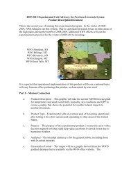
The two VAACs are responsible for the detection, analysis, and forecasting of volcanic ash<br />
plumes across their respective areas of responsibility. (Figure 1) The Washington VAAC is a<br />
partnership between the NWS and NESDIS. The NESDIS Office of Satellite and Product<br />
Operations (OSPO) Satellite Analysis Branch (SAB) is responsible for the detection, analysis,<br />
and forecasting of the volcanic ash plumes, while the NWS National Center for Environmental<br />
Prediction (NCEP) Central Operations is responsible for running and distribution of the <strong>NOAA</strong><br />
HYSPLIT ash dispersion model. The Washington VAAC staff, located at SAB, is also<br />
responsible for other programs such as tropical weather and fire/smoke analysis. The<br />
Washington VAAC is staffed 24x7x365. Both groups (NESDIS SAB and NCEP NCO) are<br />
physically located on the 4 th floor of the World Weather Building in Camp Springs, Maryland.<br />
The Washington VAAC services two U.S. and twenty one international MWOs.<br />
The Anchorage VAAC is a NWS entity which is operated by the Alaska Aviation Weather Unit<br />
(AAWU) and is part of NWS Alaska Region. The AAWU also serves as the MWO for the<br />
Anchorage Flight Information Region (FIR). The AAWU/Anchorage VAAC staffs two desks<br />
24x7x365. The VAAC desk is also staffed by the AAWU lead forecaster during eruptive events.<br />
Additional personnel are called in to assist during large volcanic ash events. The<br />
AAWU/Anchorage VAAC is co-located with the Anchorage Weather Forecast Office (WFO)<br />
and the Alaska-Pacific River Forecast Center (APRFC) in the NWS Sand Lake Facility in<br />
Anchorage, Alaska. The Anchorage VAAC services one U.S. MWO<br />
The VAACs are responsible for issuing VAA text and VAG products. (Figure 2) This is<br />
accomplished by using a wide array of remote sensing information (e.g. satellite, radar), insitu<br />
data (METAR, PIREP, Volcano Observatory reports) as well as ash dispersion and<br />
meteorological modeling output. In addition, each of the VAACs provide advice and<br />
4
NWSI <strong>10</strong>-<strong>1501</strong> FEBUARY 3, 2012<br />
consultation to the MWOs, Weather Forecast Offices (WFOs), CWSUs, VOs, FAA Air Route<br />
Traffic Control <strong>Centers</strong> (ARTCCs) and many other partners and users.<br />
The FAA is the meteorological authority, as defined by ICAO, for the United States, and works<br />
closely with the NWS on U.S. VAAC requirements. The FAA designated the NWS as the<br />
meteorological provider. The FAA represents U.S. interests at ICAO IAVW meetings and the<br />
U.S. VAAC managers generally serve as technical advisors to the FAA.<br />
5. <strong>Volcanic</strong> <strong>Ash</strong> <strong>Advisory</strong> <strong>Centers</strong> (VAACs)<br />
The VAAC is defined in ICAO Annex 3, Meteorological Service for International Air<br />
Navigation, Section 3.5, as a meteorological center designated by regional air navigation<br />
agreement to provide advisory information to meteorological watch offices, area control centers,<br />
flight information centers, World Area Forecast <strong>Centers</strong> (WAFCs) and international OPMET<br />
databanks regarding the lateral and vertical extent and forecast movement of volcanic ash in the<br />
atmosphere following volcanic eruptions. VAAC information includes text based VAA and<br />
graphical based VAG products.<br />
6. Groups Addressing <strong>Volcanic</strong> <strong>Ash</strong> Services<br />
There are several groups both within the United States and internationally that are addressing<br />
volcanic ash service issues. <strong>NOAA</strong> VAWG (<strong>Volcanic</strong> <strong>Ash</strong> Working Group) team members<br />
actively participate as partners in these collaborative activities. The following is a partial list of<br />
volcanic ash services related activities and a list of <strong>NOAA</strong> VAWG members who are associated<br />
with these groups.<br />
6.1 ICAO International Airways Volcano Watch Operations Group (IAVWOPSG)<br />
The ICAO IAVWOPSG is an active group that meets several times per year either through<br />
telcon or face to face meetings in Silver Spring, MD or Washington, DC. The U.S. working<br />
group to the IAVWOPSG is comprised of many of the members of the Office of the Federal<br />
Coordinator for Meteorology (OFCM) Working Group/<strong>Volcanic</strong> <strong>Ash</strong> (WG/VA). The chair of<br />
the U.S. delegation is the FAA (U.S. Meteorological Authority), and the technical leads are the<br />
two U.S. VAAC managers. The IAVWOPSG group meets formally every eighteen months to<br />
work on the policy and procedures for the upcoming amendments to ICAO Annex 3 or changes<br />
to the ICAO IAVW Handbook (Doc9766)<br />
Anchorage and Washington VAAC Managers, NWS <strong>Volcanic</strong> <strong>Ash</strong> Program Manager, <strong>NOAA</strong><br />
ARL HYSPLIT program (working group members)<br />
6.2 ICAO International Airways Volcano Task Force (IAVTF)<br />
This group was formed as a result of the Eyjafjallajökull eruptions. The first meeting was held at<br />
ICAO Headquarters in Montreal on July 27-30, 20<strong>10</strong>. The FAA has the lead for the U.S. and<br />
attends these meetings with the technical leads (two VAAC managers) and the NWS National<br />
<strong>Volcanic</strong> <strong>Ash</strong> Program Manager.<br />
5
NWSI <strong>10</strong>-<strong>1501</strong> FEBUARY 3, 2012<br />
6.3 Alaska Interagency <strong>Volcanic</strong> <strong>Ash</strong> Services Working Group<br />
The Alaska Interagency (IA) group meets 2-3 times each year. The “face to face” meetings<br />
alternate between the USGS Alaska Volcano Observatory (AVO) and the NWS Forecast Facility<br />
in Anchorage. The group consists of members from <strong>NOAA</strong>/NWS, FAA, USGS AVO, United<br />
States Coast Guard, Alaska Department of Homeland Security and Emergency Management,<br />
State of Alaska Department of Environmental Conservation Division of Air Quality, State of<br />
Alaska Health and Human Services and Joint Task Force Alaska (Department of Defense).<br />
NWS Alaska Region <strong>Volcanic</strong> <strong>Ash</strong> Program Manager (co-chair), Anchorage VAAC Manager,<br />
WFO Anchorage WCM, Anchorage CWSU (ZAN) MIC (members)<br />
6.4 National Marine Volcano Impacts Team (NMVIT)<br />
This <strong>NOAA</strong> led team meets several times per year via telcon to discuss specific issues with<br />
respect to volcano hazards and marine issues. <strong>NOAA</strong>s National Center for Environmental<br />
Predictions Ocean Prediction Center leads this group which consists of <strong>NOAA</strong>/NWS, USGS<br />
Volcano Observatories and the United States Coast Guard.<br />
NCEP Ocean Prediction Center WCM (lead), NWS <strong>Volcanic</strong> <strong>Ash</strong> Program Manager,<br />
Anchorage and Washington VAAC Managers, WFO Anchorage WCM (members)<br />
6.5 Office of the Federal Coordinator for Meteorology (OFCM)<br />
The OFCM Working Group for <strong>Volcanic</strong> <strong>Ash</strong> (WG/VA) is an active group that meets several<br />
times per year either through telcon or face to face meetings in Silver Spring, MD. The group is<br />
comprised of representatives from several agencies including FAA, <strong>NOAA</strong>, USGS, Department<br />
of Defense (DOD) Air Force Weather Agency (AFWA), National Aeronautics and Space<br />
Administration (NASA), Smithsonian Institute (SI), and Airline Pilots Association (ALPA).<br />
NWS <strong>Volcanic</strong> <strong>Ash</strong> Program Manager (co-chair), Anchorage and Washington VAAC Managers,<br />
<strong>NOAA</strong> ARL HYSPLIT program manager (members)<br />
6
NWSI <strong>10</strong>-<strong>1501</strong> FEBUARY 3, 2012<br />
Figure 1: VAACs of the World (per ICAO Annex 3)<br />
7
NWSI <strong>10</strong>-<strong>1501</strong> FEBUARY 3, 2012<br />
6.6 Example of a VAA and VAG<br />
VAA<br />
FVAK23 PAWU 021556<br />
VAAAK3<br />
VA ADVISORY<br />
DTG: 20090402/1600Z<br />
VAAC: ANCHORAGE<br />
VOLCANO: REDOUBT 1<strong>10</strong>3-03<br />
PSN: N6029 W15245<br />
AREA: SOUTH CENTRAL ALASKA<br />
SUMMIT ELEV: <strong>10</strong>198 FT/3<strong>10</strong>9 M<br />
ADVISORY NR: 2009-56<br />
INFO SOURCE: PIREPS/RADAR/AVO/SURFACE OBSERVATIONS<br />
AVIATION COLOUR CODE: RED<br />
ERUPTION DETAILS: LOW LEVEL ASH EMISSIONS CONTINUE<br />
OBS VA DTG: 16/1530 UTC<br />
OBS VA CLOUD: SFC/FL150 N6114 W15043 - N6037 W14937 - N5955 W15020 -<br />
N6007 W15305 - N6024 W15308 - N6114 W15043 MOVING NE 25 KNOTS.<br />
FCST VA CLOUD +6 HR: 02/2200Z SFC/FL150 N6116 W15156 - N6040 W14859 -<br />
N5957 W<strong>1501</strong>2 - N6007 W15305 - N6025 W15322 - N6116 W15156<br />
FCST VA CLOUD +12 HR: 03/0400Z SFC/FL150 N6117 W15211 - N6044 W14941<br />
- N6017 W14958 - N5947 W15338 - N6029 W15322 - N6117 W15211<br />
FCST VA CLOUD +18 HR: 03/<strong>10</strong>00Z SFC/FL150 N6117 W15416 - N6<strong>10</strong>4 W15040<br />
- N5949 W15043 - N6011 W15443 - N6117 W15416<br />
REMARKS: NONE<br />
NXT ADVISORY: 20090402/2200Z<br />
DH APR 2009<br />
8
NWSI <strong>10</strong>-<strong>1501</strong> FEBUARY 3, 2012<br />
VAG<br />
Figure 2: Example of a VAG<br />
7. Dispersion and Trajectory Models<br />
Dispersion and trajectory model output is utilized by the VAACs to assist with the preparation of<br />
forecast ash boundaries. The models should be initiated as soon as possible after ash is detected<br />
to allow timely preparation of forecast positions. The model output may also assist with the<br />
detection of ash on satellite imagery, as it can give an idea of where the ash may be expected to<br />
be on the image.<br />
9
NWSI <strong>10</strong>-<strong>1501</strong> FEBUARY 3, 2012<br />
The primary (official) dispersion model used by the Anchorage and Washington VAACs is the<br />
HYSPLIT model (Hybrid Single Particle Lagrangian Integrated Trajectory model). Other models<br />
are consulted such as the PUFF model (http://puff.images.alaska.edu/monitoring.shtml) and<br />
CANERM (Canadian). <strong>NOAA</strong>’s Air Resources Laboratory (ARL) also distributes trajectory<br />
forecasts which are frequently used by the forecasters as well<br />
(http://ready.arl.noaa.gov/READY_traj_alaska.php).<br />
8. U.S. VAAC Description<br />
8.1 Anchorage VAAC<br />
Although the area of the Anchorage <strong>Volcanic</strong> <strong>Ash</strong> <strong>Advisory</strong> Center is one of the smallest VAAC<br />
areas, it covers air routes over some of the most active volcanic areas in the world. Alaska has 80<br />
percent of all active U.S. volcanoes and 8 percent of the active volcanoes world-wide. Alaska<br />
contains over <strong>10</strong>0 volcanoes and over 40 of these have been active in historic time.<br />
The north Pacific air routes connecting Alaska to the Far East carry <strong>10</strong>,000 people per day, and<br />
up to 50,000 aircraft per year. Some routes pass over the Kamchatka Peninsula with its 32<br />
volcanoes. The Anchorage VAAC in cooperation with the AVO and the Kamchatka <strong>Volcanic</strong><br />
Eruption Response Team has initiated a series of informal agreements to provide advisory<br />
assistance about volcanic activity on the Kamchatka Peninsula.<br />
The AVO continuously monitors several of the Aleutian volcanoes and relaying its observations<br />
and forecasts to the NWS and the FAA.<br />
How the process works:<br />
<br />
<br />
<br />
<br />
<br />
AAWU VAAC meteorologists use input from the AVO, satellite pictures, radar imagery<br />
and pilot reports to determine if an eruption has occurred and to understand the intensity<br />
of the eruption.<br />
An eruption SIGMET is issued to warn pilots about the danger.<br />
One or more computer models are used to forecast ash movement in the atmosphere<br />
HYSPLIT, PUFF and/or CANERM.<br />
A VAA is issued describing the three-dimensional location of the ash. An accompanying<br />
graphic is also issued (VAG).<br />
SIGMETs and advisories are updated to keep everyone current with the situation.<br />
8.1.1 Anchorage VAAC Duties<br />
During a volcanic event, the AAWU initiates the Anchorage VAAC. The Anchorage VAAC<br />
responsibilities are handled by the AAWU lead forecaster, however during significant eruptive<br />
events, the VAAC requires it own staffing. The AAWU does have a VAAC desk (fully<br />
equipped with AWIPS, administrative pc and phone) to facilitate this function.<br />
During a significant eruptive event the following options are available:<br />
<br />
Lead forecaster “load sheds” to the North Desk (as appropriate) and takes on VAAC<br />
duties<br />
<strong>10</strong>
NWSI <strong>10</strong>-<strong>1501</strong> FEBUARY 3, 2012<br />
<br />
<br />
<br />
Lead forecaster calls on administrative shift forecaster (if available) to assume AAWU<br />
and/or VAAC duties<br />
Lead forecaster calls on Meteorologist In Charge (MIC) or Scientific Operations Officer<br />
(SOO) to assume either routine aviation (AAWU) duties or VAAC duties. Note that MIC<br />
or SOO may be busy with DHS&EM calls, coordination with other VAACs or MWO<br />
office managers, media calls, etc.<br />
Lead forecaster calls in overtime shift to cover AAWU and/or VAAC duties<br />
A volcanic event can range from a minor impact event (e.g. low level eruption in Kamchatka or<br />
Aleutians) to a high impact event (Cook Inlet volcano event).<br />
The following products are issued by the VAAC forecaster:<br />
VAA and VAG (every 6 hours and updated as needed)<br />
<strong>Volcanic</strong> <strong>Ash</strong> SIGMET (AAWU only-every 6 hours and updated or amended as needed)<br />
Provide input parameters and coordinate with NCEP NCO on HYSPLIT run<br />
o Using the 4 ash reduction results provided by NCEP NCO, Anchorage VAAC<br />
forecaster then needs to validate which solution is correct (by using remote<br />
sensing/observational data)<br />
o Anchorage VAAC forecaster then coordinates with NCEP NCO to advise on<br />
which reduction to disseminate long line<br />
o The VAAC forecaster also runs the PUFF model and uses Hypothetical<br />
trajectories provided by the ARL to aid in VAA/VAG/SIGMET production<br />
8.2 Washington VAAC<br />
The Washington VAAC (W-VAAC) is a collaborative effort of both NWS’s NCEP and the<br />
NESDIS Office of Satellite and Product Operations (OSPO), Satellite Analysis Branch (SAB).<br />
Most of the duties of the VAAC however are performed by the satellite analysts in SAB. The<br />
NCEP portion of the W-VAAC is responsible for maintaining and running of the HYSPLIT<br />
model in a 24/7 operational environment on its computer system. NCEP also runs the Global<br />
Forecast System (GFS) atmospheric model four times a day in 6-hour cycles for input to the<br />
HYSPLIT model.<br />
8.2.1 W-VAAC Duties<br />
The analysis of imagery and issuance of both the VAA and VAG are done by the SAB satellite<br />
analyst. When ash is reported or detected within the Washington VAAC boundaries, the analyst<br />
will discontinue other operational activities and immediately begin gathering information about<br />
the ash/eruption.<br />
<br />
<br />
<br />
The first priority is to notify the affected MWO(s) usually by phone to facilitate their<br />
issuance of a <strong>Volcanic</strong> <strong>Ash</strong> SIGMET.<br />
Next, the analyst prepares a VAA.<br />
If ash is detectable in satellite imagery, a VAG is also issued. The VAG consists of the<br />
current horizontal and vertical extent of the ash “cloud” and the +06, +12 and +18 hour<br />
forecasted positions of the ash.<br />
11
NWSI <strong>10</strong>-<strong>1501</strong> FEBUARY 3, 2012<br />
While the analysis of the ash cloud is being done, the NCEP Senior Duty Meteorologist sets up a<br />
file containing the inputs for the volcanic ash plume provided by SAB. The SDM then runs the<br />
model by requesting the NCO Systems Operations Specialist (SOS) to run the computer job to<br />
generate the HYSPLIT graphic. Upon model completion, the graphic output is reviewed for<br />
consistency with the meteorology fields, satellite imagery, and any observed data in the vicinity<br />
of the ash cloud. Once satisfied with the HYSPLIT depiction, another computer job is run to<br />
disseminate the HYSPLIT output to the NWSTG for distribution to users. VAA, VAG and<br />
HYSPLIT are updated at least every six hours, but sooner if the ash situation changes<br />
substantially.<br />
9. Distribution of Products<br />
VAAC products are available from the following communications circuits:<br />
<br />
<br />
<br />
<br />
<br />
<br />
VAA: Global Telecommunications System (GTS) and Family of Services (FOS)<br />
VAA and VAG, SIGMETS: AAWU Internet home pages (AAWU and VAAC)<br />
VAA, graphic and HYSPLIT: SSD Internet home pages<br />
VAA (no graphic), HYSPLIT: World Area Forecast Satellite Broadcast System<br />
(WAFS)<br />
HYSPLIT: Digital Facsimile (DIFAX)<br />
VAA (no graphic): Advanced Weather Interactive Processing System (AWIPS), and<br />
Aeronautical Fixed Telecommunications Network (AFTN)<br />
FAXING SERVICES are discouraged as an operational method of dissemination.<br />
<strong>10</strong>. Areas of Responsibility<br />
Anchorage VAAC: The Anchorage VAAC area includes the entire Anchorage FIR in addition<br />
to an area bounded on the west by 150 E longitude and on the south by 60 N latitude. This area<br />
includes all of the volcanoes within the state of Alaska and closely monitors adjacent volcanoes<br />
located in Kamchatka Peninsula and the Northern Kurile Islands of Russia.<br />
Within the Anchorage VAACs area of responsibility are NOPAC jet routes that link North<br />
America with Asia. The jet routes pass within close proximity of over <strong>10</strong>0 historically active<br />
volcanoes. Significant eruptions, which produce ash to heights greater than FL250, can greatly<br />
impact air traffic across the North Pacific region. In 2008, 62,778 flights were made across the<br />
NOPAC routes, a decrease of 22% from 2007. However, Polar flights are slowly increasing,<br />
5465 Polar routes were flown. Between the Polar routes and the NOPAC routes are the Russian<br />
Trans-East routes. There were 18,030 flights on the Russian Trans-East routes in 2008.<br />
Washington VAAC: The Washington VAACs area of responsibility stretches from 40 degrees<br />
West to 130 degrees East and includes the areas of the United States Continental, New York and<br />
Oakland Oceanic Flight information Regions (FIR) and southward through Central America, the<br />
Caribbean to <strong>10</strong> degrees South in South America.<br />
12
NWSI <strong>10</strong>-<strong>1501</strong> FEBUARY 3, 2012<br />
11. Transfer of Responsibility of <strong>Volcanic</strong> <strong>Ash</strong> Products<br />
In cases where volcanic ash cloud crosses the boundary between VAAC areas of responsibility,<br />
the first VAAC should retain responsibility for the issuance of advisories until such time as the<br />
handover of responsibility has been agreed between VAACs. Standardized operational<br />
procedures for the coordination and transfer of responsibility between VAACs for volcanic ash<br />
events are located in the IAVW Handbook (DOC 9766) and are explained below.<br />
Note: In other words, while the volcanic ash cloud straddles the common boundary, only one<br />
VAAC will issue advisories at any time, and these advisories are sent by each VAAC to MWOs<br />
and ACCs in their respective areas of responsibility.<br />
VAACs should insert a note in their “last”/“first” advisory of the message and graphical series in<br />
the remarks section that the “hand-off” will take place at that message/graphic number.<br />
As soon as one of the VAACs learns of an eruption (for a volcano erupting within<br />
5º degrees latitude of the VAACs boundary) or when an ash cloud is expected to come<br />
within 5º (latitude) of the VAACs and/or FIR boundary, an information /coordination<br />
phone call will be made. The possibility of a hand-off will be discussed, if appropriate.<br />
Hand-off of operational responsibility is coordinated by the lead VAAC with adjacent affected<br />
VAACs and MWOs when the ash cloud is not less than 5º (latitude) from a VAAC and/or FIR<br />
boundary. In the rare situation of large or persistent ash emissions, adjacent responsible VAACs,<br />
upon coordination, may agree to divide the operational forecast responsibility.<br />
Once a hand-off has been decided, the last volcanic ash advisory issued by the<br />
lead VAAC before hand-off will include the following at the end of the message (in the<br />
REMARKS):<br />
“THE RESPONSIBILITY FOR THIS ASH EVENT IS BEING TRANSFERRED TO VAAC<br />
aaaa THE NEXT ADVISORY WILL BE ISSUED BY VAAC aaaa BY xxxx UTC UNDER<br />
HEADER bbbb.”<br />
Where:<br />
aaaa is the name of the VAAC taking over<br />
bbbb is the bulletin header that will be used by the VAAC taking over (FVCN01 CWAO,<br />
FVXX21 KWBC, FVAK20 PANC, etc.)<br />
xxxx is the time in UTC<br />
Example:<br />
“THE RESPONSIBILITY FOR THIS ASH EVENT IS BEING TRANSFERRED TO VAAC<br />
MONTREAL. THE NEXT ADVISORY WILL BE ISSUED BY VAAC MONTREAL BY 2200<br />
UTC UNDER HEADER FVCN01 CWAO.”<br />
The first volcanic ash advisory issued by the VAAC that has taken over responsibility will<br />
include the following:<br />
“VAAC cccc HAS TRANSFERRED RESPONSIBILITY OF THIS EVENT TO VAAC<br />
13
NWSI <strong>10</strong>-<strong>1501</strong> FEBUARY 3, 2012<br />
dddd. THIS ADVISORY UPDATES MESSAGE eeee.”<br />
Where:<br />
cccc is the name of the VAAC which had the lead before the hand-off<br />
dddd is the name of the VAAC which has taken over<br />
eeee is the full bulletin header (e.g FVAK PANC 261200) of the last message issued by<br />
the VAAC which had the lead before the hand-off.<br />
Example:<br />
“VAAC ANCHORAGE HAS TRANSFERRED RESPONSIBILITY OF THIS EVENT TO<br />
VAAC MONTREAL. THIS ADVISORY UPDATES MESSAGE FVAK20 PANC<br />
261200.”<br />
When the lead VAAC is issuing messages covering a portion of another VAAC’s area of<br />
responsibility, or an ash cloud is approaching (within 5 degrees of latitude) the area of<br />
responsibility of a non-lead VAAC, the non-lead VAAC should issue a volcanic ash advisory<br />
directing the user to the correct product. It should be noted that the Washington and Anchorage<br />
VAACs refer to these as “near” or “pointer” VAAs.<br />
The following wording is suggested:<br />
“PLEASE SEE ffff ISSUED BY VAAC gggg WHICH DESCRIBES CONDITIONS OVER OR<br />
NEAR THE VAAC hhhh AREA OF RESPONSIBILITY.”<br />
Where:<br />
ffff is the full bulletin header of the message issued by the lead VAAC<br />
gggg is the name of the lead VAAC<br />
hhhh is the name of the VAAC re-broadcasting the lead VAAC message<br />
Example of rebroadcast message issued by VAAC Montreal:<br />
PLEASE SEE FVAK20 PANC 121200 ISSUED BY VAAC ANCHORAGE WHICH<br />
DESCRIBES CONDITIONS OVER OR NEAR THE VAAC MONTREAL AREA OF<br />
RESPONSIBILITY”<br />
Example of rebroadcast message issued by Anchorage VAAC:<br />
FVAK23 PAWU 061818<br />
VAAAK3<br />
VA ADVISORY<br />
VAAC: ANCHORAGE<br />
VOLCANO: KIZIMEN <strong>10</strong>00-23<br />
PSN: N5508 E16019<br />
AREA: KAMCHATKAN PENINSULA<br />
SUMMIT ELEV: 8201 FT/2485 M<br />
ADVISORY NR: 2011/001<br />
14
NWSI <strong>10</strong>-<strong>1501</strong> FEBUARY 3, 2012<br />
PLEASE SEE FVFE01 RJTD ISSUED BY TOKYO VAAC WHICH DESCRIBES<br />
CONDITIONS OVER OR NEAR THE ANCHORAGE VAAC AREA OF RESPONSIBILITY.<br />
For situations in which two or more distinct ash clouds would be present (different eruptions or<br />
one eruption for which the ash cloud has divided in two or more distinct parts), the “hand-off”<br />
only applies to the ash cloud approaching or crossing VAAC boundaries.<br />
The ending of an advisory for a volcanic ash event is performed by the lead VAAC upon<br />
coordination with the adjacent affected VAACs and MWOs.<br />
Only the lead VAAC issues volcanic ash advisories in graphical format on ISCS or SADIS.<br />
12. Backup<br />
The Washington VAAC performs back up operations for the Anchorage VAAC. The Air Force<br />
Weather Agency (AFWA) performs back up operations for the Washington VAAC. Back up<br />
procedures are defined in Appendix D of the IAVW Handbook (DOC 9766).<br />
13. Contact information for Anchorage and Washington VAAC<br />
ANCHORAGE (Alaska, USA)<br />
Supervisor<br />
Mailing Address<br />
AFTN address<br />
VAA WMO header<br />
VAG WMO header<br />
Internet home page<br />
Hours of operation<br />
Alaska Aviation Weather Unit - Meteorologist in Charge<br />
Alaska Aviation Weather Unit<br />
6930 Sand Lake Road<br />
Anchorage, Alaska, USA 99502<br />
via KWBCYMYX<br />
FVAK21-25 PAWU<br />
PFXD21-25 PAWU<br />
http://vaac.arh.noaa.gov<br />
24 hour/day<br />
Trajectory/dispersion model HYSPLIT, PUFF dispersal model<br />
HYSPLIT dispersal model development: <strong>NOAA</strong> ARL<br />
Run PUFF: http://pafc.arh.noaa.gov/puffweb2/puffweb.php<br />
WASHINGTON (D.C., USA)<br />
Occasionally reference the MLDP0 (Canadian) dispersal models<br />
Supervisor<br />
Satellite Analysis Branch, NESDIS<br />
Mailing Address 5200 Auth Road, Room 401<br />
Camp Springs, MD 20746<br />
15
NWSI <strong>10</strong>-<strong>1501</strong> FEBUARY 3, 2012<br />
VAA WMO Headers FVXX KNES 20-27<br />
Internet home page VAAS: http://www.ssd.noaa.gov/VAAC/<br />
HYSPLIT: http://www.ssd.noaa.gov/VAAC/vaftad.html<br />
Hours of operation<br />
24 hours/day<br />
Trajectory /dispersion model HYSPLIT dispersal model development: <strong>NOAA</strong> ARL<br />
<strong>NOAA</strong> Air Resources Laboratory<br />
Office of Oceanic and Atmospheric Research<br />
16