Managed Aquifer Recharge for the Arizona Desert - National Water ...
Managed Aquifer Recharge for the Arizona Desert - National Water ...
Managed Aquifer Recharge for the Arizona Desert - National Water ...

Create successful ePaper yourself
Turn your PDF publications into a flip-book with our unique Google optimized e-Paper software.
ABSTRACT & POWERPOINT PRESENTATION<br />
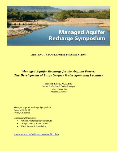
<strong>Managed</strong> <strong>Aquifer</strong> <strong>Recharge</strong> <strong>for</strong> <strong>the</strong> <strong>Arizona</strong> <strong>Desert</strong>:<br />
The Development of Large Surface <strong>Water</strong> Spreading Facilities<br />
Mario R. Lluria, Ph.D., P.G.<br />
Senior Professional Geohydrologist<br />
Hydrosystems, Inc.<br />
Phoenix, <strong>Arizona</strong><br />
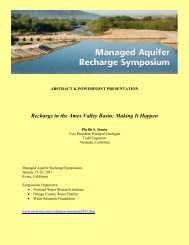
<strong>Managed</strong> <strong>Aquifer</strong> <strong>Recharge</strong> Symposium<br />
January 25-26, 2011<br />
Irvine, Cali<strong>for</strong>nia<br />
Symposium Organizers:<br />
• <strong>National</strong> <strong>Water</strong> Research Institute<br />
• Orange County <strong>Water</strong> District<br />
• <strong>Water</strong> Research Foundation<br />
www.nwri-usa.org/rechargesymposium2011.htm
<strong>Managed</strong> <strong>Aquifer</strong> <strong>Recharge</strong> For The <strong>Arizona</strong> <strong>Desert</strong>: The development of large surface waterspreading<br />
facilities<br />
Mario R. Lluria, Gary G. Small and Floyd Marsh<br />
Hydrosystems, Inc., Phoenix, <strong>Arizona</strong><br />
For decade’s agriculture, industry and <strong>the</strong> urban areas of sou<strong>the</strong>rn <strong>Arizona</strong> relied principally on<br />
groundwater <strong>for</strong> its sustenance, development and growth. Although Phoenix had a limited supply<br />
of surface water from <strong>the</strong> Salt River Project (SRP) surface reservoirs on <strong>the</strong> Salt and Verde<br />
Rivers this source is subjected to extreme wea<strong>the</strong>r changes typical of this semi-arid region of<br />
North America. The considerable overdraft of <strong>the</strong> aquifers limited <strong>the</strong>ir continued use as <strong>the</strong><br />
main water supply. Import of surface water, water re-use, water conservation and strict control of<br />
groundwater abstraction were implemented. In 1993 <strong>the</strong> Central <strong>Arizona</strong> Project Aqueduct,<br />
which conveys all of <strong>Arizona</strong>’s Colorado River (CAP) water entitlement, was completed. To<br />
store and manage this new water resource, large storage facilities were needed but none existed.<br />
One small surface reservoir was built by enlarging an existing one. However, many more were<br />
needed especially adequately distributed regionally to serve <strong>the</strong> numerous and widely spread<br />
agriculture and urban centers. Since <strong>the</strong> available volumes of CAP water were large <strong>the</strong> storage<br />
facilities needed to be of considerable capacity. Surface water-spreading facilities were <strong>the</strong> most<br />
adequate <strong>for</strong> that purpose. Given <strong>the</strong> necessary hydrogeologic conditions, <strong>the</strong>y are <strong>the</strong> more costeffective<br />
and rapid construction and operation alternative. The Salt River Project in partnership<br />
with six Phoenix area municipalities constructed and started <strong>the</strong> operation of <strong>the</strong> Granite Reef<br />
Underground Storage Project (GRUSP) in May, 1994. This facility consisting of seven recharge<br />
basins constructed in <strong>the</strong> dry channel of <strong>the</strong> Salt River has stored to date (12/2009)<br />
approximately one million acre-feet of CAP water and smaller volumes of reclaimed water. Its<br />
operation has notably contributed to replenish <strong>the</strong> aquifer, improved <strong>the</strong> groundwater quality and<br />
improved <strong>the</strong> management of <strong>the</strong> water resources of several of its users. The GRUSP has an<br />
annual capacity under favorable conditions of 100,000 acre-feet. This pioneer project was<br />
followed by several o<strong>the</strong>r large water-spreading facilities in Phoenix and in <strong>the</strong> city of Tucson.<br />
Today <strong>the</strong>re are ten o<strong>the</strong>r large facilities with a total annual aquifer storage capacity of<br />
approximately 650,000 acre-feet of water. Most store CAP water except GRUSP and SRP’s<br />
NAUSP facility which also store reclaimed water and Salt and Verde Rivers water. These<br />
facilities with minor contributions from many small surface water-spreading facilities, which<br />
predominantly store reclaimed water, have made <strong>the</strong> use of MAR as a very appropriate and<br />
successful technology <strong>for</strong> <strong>the</strong> management of <strong>the</strong> limited water resources of this fast growing<br />
desert area of <strong>the</strong> southwestern U.S.A. When sufficient land is not available because of its high<br />
cost or space limitation due to high urban development, some municipalities store <strong>the</strong>ir CAP<br />
water in <strong>the</strong> aquifer using vadose zone recharge wells. The <strong>Water</strong> Campus facility in Scottsdale,<br />
<strong>Arizona</strong> uses <strong>the</strong>se wells to recharge both CAP water and reclaimed water. <strong>Aquifer</strong> Storage<br />
Recovery (ASR) wells are much less frequently used to recharge CAP water in <strong>Arizona</strong> because<br />
of <strong>the</strong> much higher storage unit cost as compared to surface water-spreading basins or vadose<br />
zone recharge wells. The SRP has tested an ASR system using treatment of raw canal water at<br />
<strong>the</strong> wellhead and employing existing deep production wells located next to <strong>the</strong>ir canal system<br />
that could become operational in <strong>the</strong> future.
A Historical Overview
• M.A.R. Development<br />
– Main Reasons <strong>for</strong> its Progress<br />
– Development Phases<br />
– Regulatory Framework<br />
– <strong>Water</strong>‐Spreading vs Well <strong>Recharge</strong><br />
– Institutional Involvement<br />
• <strong>Water</strong>‐Spreading Facilities<br />
• The Future of <strong>Water</strong> Spreading
This phase consisted mostly of tests by Universities and research centers<br />
Flushing Meadow Project<br />
Phoenix, AZ<br />
• Off‐channel basins in <strong>the</strong> Salt River<br />
• Treated effluent<br />
• SAT<br />
• Dr. Herman Bouwer, USDA /<br />
USWCL (1968‐1978)<br />
Basin <strong>Recharge</strong> in McMicken Dam*<br />
Phoenix, AZ<br />
• Well recharge using cooling tower<br />
effluent in Tucson<br />
• Dr. L.G. Wilson and o<strong>the</strong>rs at<br />
University of <strong>Arizona</strong> WRRC<br />
(1960’s)<br />
*Photo: Flood Control District of Maricopa County
Sweetwater Project*<br />
Tucson, AZ<br />
• Reclaimed water<br />
• Four 0.75 acre basins<br />
Granite Reef Underground<br />
Storage Project<br />
Phoenix, AZ<br />
• Studies and design<br />
completed<br />
• Full scale<br />
• CAP water<br />
<strong>Water</strong> Campus Project<br />
Scottsdale, AZ<br />
• Vadose zone recharge<br />
wells<br />
• Reclaimed water<br />
Cave Creek <strong>Recharge</strong><br />
Project<br />
Phoenix, AZ<br />
• First ASR well in <strong>Arizona</strong><br />
*Photo: ADWR Website
Granite Reef Underground<br />
Storage Project<br />
Phoenix, AZ<br />
• 1994 commenced<br />
operation<br />
• Permitted <strong>for</strong> 200,000<br />
acre‐feet/year<br />
9 Large <strong>Water</strong>‐Spreading<br />
Facilities<br />
• 1994 ‐2010<br />
• Capacity exceeding<br />
50,000 acre‐feet/year<br />
CAP Aqueduct*<br />
• Completed to Phoenix<br />
and Tucson<br />
*Photo: CAP Website
City of Surprise SPA‐1<br />
Surprise, AZ<br />
• Vadose Zone <strong>Recharge</strong><br />
Wells<br />
Hassayampa <strong>Recharge</strong><br />
Facility<br />
Near Prescott, AZ<br />
• <strong>Water</strong>‐Spreading by<br />
river channel<br />
Fountains Sanitary District<br />
Fountain Hills, AZ<br />
• ASR Wells
Agencies<br />
Army Corps of<br />
Engineers<br />
Federal State County /<br />
Municipality<br />
Environmental<br />
Protection<br />
Agency<br />
<strong>Arizona</strong> Department<br />
of <strong>Water</strong> Resources<br />
<strong>Arizona</strong> Department<br />
of Environmental<br />
Quality<br />
Flood Control<br />
District<br />
Permits 404 401 • Underground<br />
Storage Facility<br />
• <strong>Water</strong> Storage<br />
Laws<br />
Clean <strong>Water</strong><br />
Act<br />
Clean <strong>Water</strong><br />
Act<br />
• 1980 Groundwater<br />
Management Act<br />
• <strong>Recharge</strong> and<br />
Underground<br />
Storage and<br />
Recovery Act 1986<br />
<strong>Aquifer</strong> Protection<br />
Permit<br />
Environmental<br />
Quality Act 1986<br />
Floodplain and<br />
Flood Use Permit<br />
Local Ordinance
<strong>Water</strong>‐Spreading ASR Well Vadose Zone Well<br />
Capacity 5,000 – 150,000 ac‐ft/yr < 5,000 ac‐ft/d 1,000 – 15,000 ac‐ft/yr<br />
<strong>Water</strong> Source CAP, RW, S&V, Mixed RW, CAP RW<br />
Unit Cost ($/ac‐ft) Very low High Intermediate<br />
Number of Facilities 38 9 19
• Central <strong>Arizona</strong> <strong>Water</strong> Conservation District (CAWCD)<br />
– Colorado River <strong>Water</strong> Purveyor<br />
• <strong>Arizona</strong> <strong>Water</strong> Banking Authority (AWBA)<br />
– Better Utilization of <strong>Arizona</strong>: Colorado River Entitlement<br />
• Groundwater Replenishment Districts<br />
• Salt River Project (SRP)<br />
– Salt and Verde Rivers <strong>Water</strong> Purveyor<br />
• Municipalities<br />
• Irrigation Districts<br />
• <strong>Water</strong> Companies
• <strong>Water</strong> Sources Available <strong>for</strong> <strong>Aquifer</strong> Storage<br />
– Colorado River <strong>Water</strong> (CAP)<br />
– Salt and Verde River <strong>Water</strong> (SRP)<br />
– Reclaimed <strong>Water</strong> (treated municipal<br />
effluent) (RW)<br />
– Treated Industrial Effluent (IRW)
• Granite Reef Underground Storage Project<br />
– GRUSP<br />
• New River Agua Fria Underground Storage<br />
Project<br />
– NAUSP<br />
• MBT Ranch <strong>Recharge</strong> Project<br />
• Lower Santa Cruz River <strong>Managed</strong> <strong>Recharge</strong><br />
Project<br />
– LSCRMRP<br />
• Hassayampa <strong>Recharge</strong> Facility
Roosevelt Dam<br />
<strong>Arizona</strong> Canal
West<br />
GRUSP<br />
UAU<br />
LAU<br />
300 ft<br />
Salt River<br />
Granite<br />
Reef Dam<br />
Mount McDowell<br />
Detachment fault<br />
Y g<br />
T M<br />
East<br />
Verde<br />
River<br />
Y g<br />
<strong>Aquifer</strong><br />
UAU<br />
LAU<br />
T M<br />
Upper Alluvial Unit-Quaternary<br />
Lower Alluvial Unit-Pleisto cene<br />
Red Unit – Fanglormerates Miocine<br />
Scale in Mile<br />
0 1<br />
2<br />
f<br />
Y g<br />
f<br />
Tovrea Granite-precambria
• Development<br />
– In‐channel basins in <strong>the</strong> Salt River<br />
– <strong>Recharge</strong> capacity<br />
• 100,000 acre‐feet/year (125 M mm3/year)<br />
– Near SRP and CAP water infrastructure<br />
– Started operation in 1994<br />
– Total cost<br />
• $2.2M
South<br />
Canal<br />
BCW Headworks Basins<br />
<strong>Aquifer</strong><br />
Storage
• System Components<br />
– Inflow Structures<br />
• SRP South Canal<br />
– Delivery Units<br />
• Delivery Channel<br />
– <strong>Recharge</strong> Units<br />
• 7 basins: 225 acres (90 hectares)<br />
– Monitoring System<br />
• BCWs<br />
• wells
• Site Selection<br />
– Geology<br />
– Hydrogeology<br />
– Engineering infrastructure<br />
– Environmental factors
W<br />
E<br />
White Tank<br />
Mountains<br />
BR<br />
Agua Fria River<br />
NAUSP<br />
BR<br />
Salt River<br />
GRUSP<br />
McDowell<br />
Mountains<br />
Red<br />
Mountains<br />
BR<br />
UAU<br />
MAU<br />
LAU<br />
UAU<br />
MAU<br />
LAU<br />
DF<br />
West Salt River Valley Basin<br />
East Salt River Valley Basin
Cavecreek<br />
Carefree<br />
Peoria<br />
Scottsdale<br />
Surprise<br />
El<br />
Mirage<br />
Youngtown<br />
<strong>Arizona</strong><br />
Phoenix<br />
Fountain<br />
Hills<br />
Buckeye<br />
Litchfield<br />
Park<br />
Goodyear<br />
Avondale<br />
Glendale<br />
Tolleson<br />
Grand<br />
Western<br />
Canal<br />
Canal<br />
Canal<br />
Paradise<br />
Valley<br />
Guadalupe<br />
X-Cut<br />
Tempe<br />
<strong>Arizona</strong><br />
Tempe<br />
Canal<br />
Chandler<br />
Gilbert<br />
Canal<br />
Consolidated<br />
Canal<br />
Mesa<br />
South Canal<br />
Eastern Canal<br />
Queen<br />
Creek<br />
Apache<br />
Junction
Gila<br />
Gila<br />
River<br />
River<br />
Salt River<br />
Salt River<br />
Agua<br />
Agua<br />
River<br />
River<br />
Fria<br />
Fria<br />
River<br />
River<br />
New<br />
New<br />
Avondale<br />
Buckeye<br />
Goodyear<br />
Glendale<br />
Sun<br />
City<br />
Phoenix<br />
El<br />
Mirage<br />
85<br />
10<br />
89<br />
84<br />
60<br />
-250<br />
-300<br />
-200<br />
-300<br />
-250<br />
-200<br />
-300<br />
-150<br />
-100<br />
-50<br />
Glendale<br />
Buckeye<br />
Goodyear<br />
Avondale<br />
Sun<br />
City<br />
Phoenix<br />
El<br />
Mirage<br />
LUKE<br />
AIR FORCE<br />
BASE<br />
85<br />
10<br />
89<br />
84<br />
60<br />
Gila<br />
Gila<br />
Agua<br />
Agua<br />
River<br />
River<br />
River<br />
River<br />
Salt<br />
Salt<br />
River<br />
River<br />
Fria<br />
Fria<br />
River<br />
River<br />
New<br />
New<br />
900<br />
920<br />
940<br />
960<br />
980<br />
1,000<br />
1,020<br />
1,040<br />
1,060<br />
1,080<br />
1,100<br />
1,120<br />
1,140<br />
1,160<br />
1,180<br />
1,200<br />
1,220<br />
1,240<br />
85<br />
10<br />
89<br />
84<br />
60<br />
Goodyear<br />
Glendale<br />
Buckeye Avondale<br />
Sun<br />
City<br />
Phoenix<br />
El<br />
Mirage<br />
750<br />
725<br />
850<br />
825<br />
800<br />
775<br />
750<br />
725<br />
750<br />
775<br />
800<br />
825<br />
850<br />
875<br />
River<br />
Gila<br />
River<br />
River<br />
Salt<br />
Fria<br />
River<br />
New<br />
Agua<br />
<strong>Recharge</strong><br />
Site<br />
LUKE<br />
AIR FORCE<br />
BASE<br />
LUKE<br />
AIR FORCE<br />
BASE<br />
LUKE<br />
LUKE<br />
AIR FORCE<br />
AIR FORCE<br />
BASE<br />
BASE
• Started operation in 2006<br />
• Basins<br />
– In‐channel and off‐channel<br />
• Permit capacity<br />
– 75,000 acre‐feet/year<br />
• Near SRP water infrastructure<br />
• Total cost<br />
– $13M
• <strong>Recharge</strong> units<br />
– 6 off‐channel<br />
– 1 in‐channel basins<br />
Basin 2<br />
Looking<br />
Southwest<br />
East Side
• Delivery units<br />
– Grand Canal<br />
– Reclaimed water pipelines<br />
• Monitoring units<br />
– 12 wells
• Type<br />
– <strong>Water</strong>‐Spreading/Basins<br />
– ADWR Constructed <strong>Recharge</strong> Facility<br />
• Location<br />
– Maricopa County<br />
• Ownership<br />
– Vidler <strong>Water</strong> Company<br />
• Source <strong>Water</strong><br />
– CAP<br />
• Capacity<br />
– 75,000 ac‐ft/yr
• Type<br />
– <strong>Water</strong>‐Spreading<br />
– ADWR <strong>Managed</strong> <strong>Recharge</strong> Facility<br />
• Location<br />
– Santa Cruz River Channel, Tucson<br />
• Operator<br />
– Pima County –City of Tucson<br />
• Source <strong>Water</strong><br />
– Reclaimed <strong>Water</strong><br />
• Roger Road and Ina Road WWTPs<br />
• Capacity<br />
– 45,000 ac‐ft/yr
• Type<br />
– <strong>Water</strong>‐Spreading<br />
– ADWR <strong>Managed</strong> <strong>Recharge</strong> Facility<br />
• Location<br />
– Hassayampa River, Maricopa County<br />
• Ownership<br />
– Summit Global<br />
• Operator<br />
– HydroSystems, Inc.<br />
• Source <strong>Water</strong><br />
– CAP<br />
• Capacity<br />
– 25,000 ac‐ft/yr
• Availability of unused CAP water decreases<br />
• More CAP water may become available as<br />
agriculture decreases<br />
• Cali<strong>for</strong>nia and Nevada could continue to recharge<br />
Colorado River <strong>Water</strong> in <strong>Arizona</strong>?<br />
• More reclaimed water is available <strong>for</strong> aquifer<br />
storage<br />
• New recharge projects will store predominantly<br />
reclaimed water<br />
– Medium to small projects (