Andrew Murphy Appendices to Proof of Evidence (Part 1)
Andrew Murphy Appendices to Proof of Evidence (Part 1)
Andrew Murphy Appendices to Proof of Evidence (Part 1)

Create successful ePaper yourself
Turn your PDF publications into a flip-book with our unique Google optimized e-Paper software.
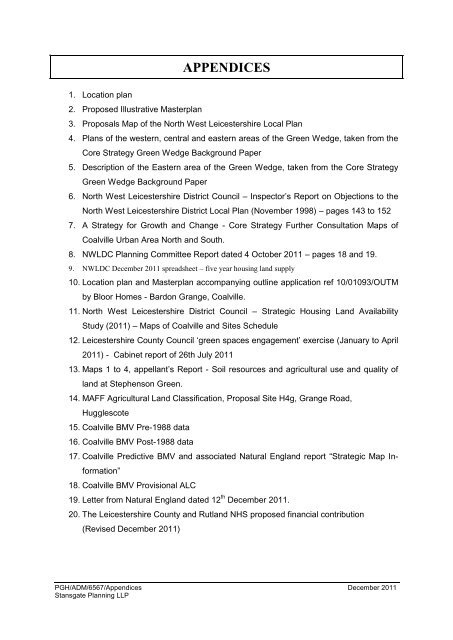
APPENDICES<br />
1. Location plan<br />
2. Proposed Illustrative Masterplan<br />
3. Proposals Map <strong>of</strong> the North West Leicestershire Local Plan<br />
4. Plans <strong>of</strong> the western, central and eastern areas <strong>of</strong> the Green Wedge, taken from the<br />
Core Strategy Green Wedge Background Paper<br />
5. Description <strong>of</strong> the Eastern area <strong>of</strong> the Green Wedge, taken from the Core Strategy<br />
Green Wedge Background Paper<br />
6. North West Leicestershire District Council – Inspec<strong>to</strong>r‟s Report on Objections <strong>to</strong> the<br />
North West Leicestershire District Local Plan (November 1998) – pages 143 <strong>to</strong> 152<br />
7. A Strategy for Growth and Change - Core Strategy Further Consultation Maps <strong>of</strong><br />
Coalville Urban Area North and South.<br />
8. NWLDC Planning Committee Report dated 4 Oc<strong>to</strong>ber 2011 – pages 18 and 19.<br />
9. NWLDC December 2011 spreadsheet – five year housing land supply<br />
10. Location plan and Masterplan accompanying outline application ref 10/01093/OUTM<br />
by Bloor Homes - Bardon Grange, Coalville.<br />
11. North West Leicestershire District Council – Strategic Housing Land Availability<br />
Study (2011) – Maps <strong>of</strong> Coalville and Sites Schedule<br />
12. Leicestershire County Council „green spaces engagement‟ exercise (January <strong>to</strong> April<br />
2011) - Cabinet report <strong>of</strong> 26th July 2011<br />
13. Maps 1 <strong>to</strong> 4, appellant‟s Report - Soil resources and agricultural use and quality <strong>of</strong><br />
land at Stephenson Green.<br />
14. MAFF Agricultural Land Classification, Proposal Site H4g, Grange Road,<br />
Hugglescote<br />
15. Coalville BMV Pre-1988 data<br />
16. Coalville BMV Post-1988 data<br />
17. Coalville Predictive BMV and associated Natural England report “Strategic Map Information”<br />
18. Coalville BMV Provisional ALC<br />
19. Letter from Natural England dated 12 th December 2011.<br />
20. The Leicestershire County and Rutland NHS proposed financial contribution<br />
(Revised December 2011)<br />
PGH/ADM/6567/<strong>Appendices</strong> December 2011<br />
Stansgate Planning LLP
Stephenson Green, Coalville - Design & Access Statement<br />
Key<br />
Site Boundary<br />
Perimeter Block -<br />
Residential<br />
School<br />
ALLOTMENTS<br />
Perimeter Block -<br />
Mixed Use<br />
PARKLAND<br />
Open Space<br />
58<br />
NATIONAL FOREST<br />
CHILDREN’S PLAY<br />
NEAP<br />
10<br />
PITCHES<br />
Surface Water<br />
Attenuation Basin (wet)<br />
Surface Water<br />
Attenuation Basin (dry)<br />
11<br />
6<br />
4<br />
Retained Hedgerow<br />
16<br />
Proposed Hedgerow<br />
17<br />
Woodland Planting<br />
13<br />
LEAP<br />
1<br />
CHILDREN’S PLAY<br />
LEAP<br />
Individual Tree<br />
14<br />
8<br />
15<br />
Retained Tree<br />
Equipped Children’s<br />
Play Area<br />
7<br />
2<br />
Shared Surface<br />
Square<br />
12<br />
‘Gateway’ Building<br />
3<br />
9<br />
COMMUNITY<br />
ORCHARD<br />
LEAP<br />
Retained Public Right<br />
<strong>of</strong> Way / Footpath<br />
Bridleway<br />
(retained and proposed)<br />
Footpath / Cycleway<br />
Pedestrian Link<br />
Shared Surface Pedestrian<br />
Friendly Route<br />
Primary Vehicular Route<br />
Primary Frontage<br />
Secondary Frontage<br />
Nodal Space<br />
N<br />
SCALE 1:5,000<br />
25 75<br />
0m 50 125 250<br />
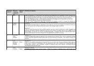
Figure 28: Illustrative Masterplan
Stephenson Green, Coalville - Design & Access Statement<br />
ILLUSTRATIVE MASTERPLAN<br />
6.14<br />
6.14.1<br />
1<br />
2<br />
3<br />
4<br />
5<br />
6<br />
7<br />
8<br />
9<br />
10<br />
11<br />
12<br />
13<br />
14<br />
15<br />
16<br />
17<br />
Design Principles - Illustrative Masterplan<br />
The illustrative masterplan design principles demonstrate how the design concept could be realised in the future development <strong>of</strong> the site; this does not<br />
represent a detailed proposal. Alternative solutions may be equally successful providing they are in accordance with the conceptual design principles<br />
stated overleaf. The development principles are set out below:<br />
Greenways will be incorporated in<strong>to</strong> the development <strong>to</strong> ensure pedestrians and cyclists have access <strong>to</strong> safe and direct routes between existing and<br />
proposed facilities, especially <strong>to</strong> and from Coalville <strong>to</strong>wn centre and Stephenson Green village centre. The emphasis will be placed on pedestrians /<br />
cyclists as the primary users and vehicles may be restricted along sections <strong>of</strong> the routes. A ‘green’ emphasis will be achieved through the use <strong>of</strong> s<strong>of</strong>t<br />
landscaping within front gardens and on street and a shared surface carriageway / footpath <strong>to</strong> denote the pedestrian friendly character.<br />
The primary vehicular route (Main Street) serves as the main connec<strong>to</strong>r road, bus route and cycleway. It is broadly linear in nature with deflections in<br />
the carriageway <strong>to</strong> aid traffic calming. Street trees and/or grass verges are proposed on both sides <strong>of</strong> the Main Street, as seen along Broom Leys Road.<br />
The intensity <strong>of</strong> the street trees may increase <strong>to</strong>wards the ‘Village’ Centre <strong>to</strong> create a heightened sense <strong>of</strong> arrival. A Village Green will act as punctuation<br />
<strong>of</strong> the primary vehicular route and contribute <strong>to</strong>wards the sense <strong>of</strong> community within the ‘Village’ Centre. Further traffic calming features will be in place<br />
<strong>to</strong> slow down the traffic flow and prevent the road becoming a ‘rat run’.<br />
The primary site access is located on Stephenson Way and is achieved via a high quality signalised junction. This junction will provide a safe crossing<br />
for pedestrians and cyclists and create a strong connection <strong>to</strong> Coalville <strong>to</strong>wn centre and Coalville Park.<br />
The secondary site access on Hall Lane will be less formal in character due <strong>to</strong> the set back distance <strong>of</strong> the proposed development from the site boundary<br />
and nature <strong>of</strong> the surrounding open space; the playing fields and woodlands will help <strong>to</strong> create a distinction between the two points <strong>of</strong> access.<br />
Three distinct character areas within the development (Parkland Edge, ‘Village’ Centre and Neighbourhood Character Area) create a sense <strong>of</strong> identity<br />
and local distinctiveness. Development will respond <strong>to</strong> the existing urban character and the overarching influence <strong>of</strong> the National Forest by using<br />
complementary building materials, built form and native plant species. Nodal spaces and a hierarchy <strong>of</strong> street typologies will further augment the ‘village’<br />
like character and aid legibility through the site.<br />
Individual dwellings will be used <strong>to</strong> create lower density development which is naturalistic in character along the Parkland Edge.<br />
A more formal development edge will be used <strong>to</strong> define the Main Street and key nodal spaces.<br />
The ‘Village’ Centre will include a primary school, village green, public square and mixed use development such as community buildings, apartments<br />
and shops creating a central hub <strong>of</strong> activity and focal point within the development. This will be highly accessible <strong>to</strong> both new and existing communities<br />
with pedestrian, cycle and vehicular links interconnecting with existing movement networks, through the site and in<strong>to</strong> the central square.<br />
Gateway buildings define the site entrances, this could be achieved through the use <strong>of</strong> design features within the built form, such as dual aspect units<br />
that address both the entrance and the primary vehicular route, and an increase in scale.<br />
Playing fields <strong>to</strong> the north <strong>of</strong> the development act as an ‘integra<strong>to</strong>r’ between proposed and existing communities and exploit a natural plateau in the<br />
landform. It also provides a convenient location for the facilities <strong>to</strong> be accessed and a space which is overlooked by proposed and existing dwellings.<br />
A strong woodland buffer is situated along the western boundary <strong>to</strong> Hermitage Road, this will help <strong>to</strong> screen proposed development from existing<br />
dwellings, prevent overlooking in<strong>to</strong> existing properties and enhance the distinction between Coalville and Whitwick. The landscaped edge will also<br />
facilitate Stephenson Green in becoming a ‘place in its own right’.<br />
Blocks <strong>of</strong> vegetation (existing and proposed) filter views in<strong>to</strong> the site along the southern boundary. In conjunction with a 25-30m setback, planted visual<br />
bunds and / or fenestration an appropriate edge <strong>to</strong> Stephenson Way can be created.<br />
Equipped areas <strong>of</strong> children’s play are designed <strong>to</strong> make best use <strong>of</strong> greenways, footpaths, cycleways and the wider green infrastructure network, ensuring<br />
that all public open space is easily accessible, useable and safe. Formal play equipment is also situated <strong>to</strong> comply with Fields in Trust recommended<br />
walking distances <strong>to</strong> make certain all residents have equipped areas <strong>of</strong> play within suitable proximity <strong>of</strong> their dwellings. Development frontage will define<br />
the areas <strong>of</strong> children’s play and provide natural surveillance making them safe places <strong>to</strong> play.<br />
The existing public rights <strong>of</strong> way located within the site are retained and enhanced where possible. Development frontage and dual aspect units provide<br />
natural surveillance, and the proposed network <strong>of</strong> open spaces and footpaths will increase their viability and encourage people <strong>to</strong> walk <strong>to</strong> and from the<br />
local centres within Coalville, Whitwick and Stephenson Green. The major movement routes will be designated as strategic greenways.<br />
Development is set back from rear property boundaries on Tiver<strong>to</strong>n Avenue, ensuring existing residents are not overlooked. The <strong>of</strong>fset will include a<br />
strong woodland buffer which will benefit from the natural surveillance <strong>of</strong> proposed development frontage. In addition shared private drives and larger<br />
front gardens may be included <strong>to</strong> maximise the distance <strong>of</strong> built form <strong>to</strong> existing back gardens.<br />
Attenuation basins are located at suitable positions throughout the site <strong>to</strong> mitigate against surface water run<strong>of</strong>f. They will also provide a key ecological<br />
habitats and an entrance feature <strong>of</strong>f Hall Lane.<br />
Specific view corridors have been integrated within the development <strong>to</strong> create visual links <strong>to</strong> surrounding highlands from within the ‘Village’ Centre,<br />
maximising the assets <strong>of</strong> both the central location and attractive landscape setting. The view <strong>to</strong>wards Bardon Hill from the ‘village’ green follows the<br />
alignment <strong>of</strong> an existing hedgerow and is defined by development frontage and the primary school. The view <strong>to</strong> Spring Hill is also appreciated from the<br />
‘village’ green and will be defined by residential built form.<br />
59