LITTLE DYER POND - Maine.gov
LITTLE DYER POND - Maine.gov
LITTLE DYER POND - Maine.gov

Create successful ePaper yourself
Turn your PDF publications into a flip-book with our unique Google optimized e-Paper software.
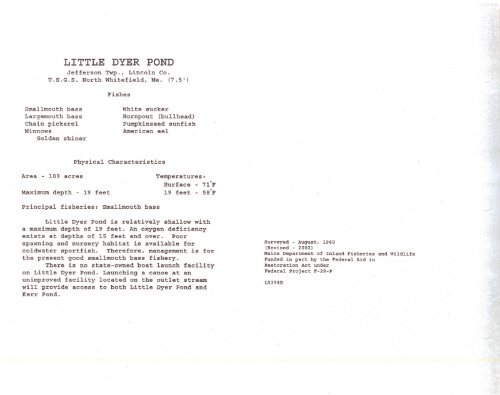
<strong>LITTLE</strong> <strong>DYER</strong> <strong>POND</strong><br />
Jefferson Twp., Lincoln Co.<br />
U.S.G.S. North Whitefield, Me. (7.5')<br />
Fishes<br />
Smallmouth bass<br />
Largemouth bass<br />
Chain pickerel<br />
Minnows<br />
Golden shiner<br />
White sucker<br />
Hornpout (bullhead)<br />
Pumpkinseed sunfish<br />
American eel<br />
Physical<br />
Characteristics<br />
Area - 109 acres<br />
Maximum depth - 19 feet<br />
Temperatures:<br />
Surface - 71·F<br />
19 feet - 5S·F<br />
Principal fisheries: Smallmouth bass<br />
Little Dyer Pond is relatively shallow with<br />
a maximum depth of 19 feet. An oxygen deficiency<br />
exists at depths of 15 feet and over. Poor<br />
spawning and nursery habitat is available for<br />
coldwater sportfish. Therefore, management is for<br />
the present good smallmouth bass fishery.<br />
There is no state-owned boat launch facility<br />
on Little Dyer Pond. Launching a canoe at an<br />
unimproved facility located on the outlet stream<br />
will provide access to both Little Dyer Pond and<br />
Kerr Pond.<br />
Surveyed - August, 1960<br />
(Revised - 2002)<br />
<strong>Maine</strong> Department of Inland Fisheries and Wildlife<br />
Funded in part by the Federal Aid in<br />
Restoration Act under<br />
Federal Project F-2B-P<br />
L5394B
N<br />
4 8 12 14 14 14 13 14 14<br />
<strong>LITTLE</strong><br />
<strong>DYER</strong> <strong>POND</strong><br />
JEFFERSON TWP., LINCOLN CO .• MAINE<br />
AREA 109 ACRES<br />
o 2<br />
iiiiiiiiiiiiiii<br />
TENTHS of MILE<br />
3 I