07 Vauxhall Square, item 6. PDF 626 KB - Lambeth Council
07 Vauxhall Square, item 6. PDF 626 KB - Lambeth Council
07 Vauxhall Square, item 6. PDF 626 KB - Lambeth Council

Create successful ePaper yourself
Turn your PDF publications into a flip-book with our unique Google optimized e-Paper software.
<strong>Vauxhall</strong>; requiring developments to comply with the maximum car parking<br />
standards in the London Plan and reflect the public transport accessibility of the<br />
development and to include provision for cycle parking, motor-cycle parking in<br />
appropriate location and car clubs wherever possible; promoting walking and<br />
cycling, including through improvements to existing provision in and around<br />
development for cycling, cycle parking, public realm and transport and highway<br />
infrastructure.<br />
10.2 Policy <strong>6.</strong>1 of the London plan aims to encourage patterns and nodes of<br />
development that reduce the need to travel, especially by car; seeking to<br />
improve the capacity and accessibility of public transport, walking and cycling,<br />
particularly in areas of greatest demand; supporting development that generates<br />
high levels of trips at locations with high public accessibility; improving<br />
interchange between different forms of transport, particularly around major rail<br />
and Underground stations, especially where this will enhance connectivity in<br />
outer London.<br />
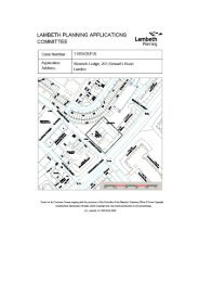
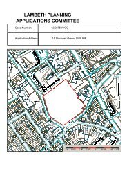
10.3 The site covers a large area and fronts on to several roads and neighbouring<br />
sites. Parry Street (A202) runs across the northern boundary of the site,<br />
Wandsworth Road to the west and Bondway runs along the majority of the<br />
eastern boundary; Miles Street bisects the site with a continuation of the<br />
development southwards following the viaduct to its junction with Wandsworth<br />
Road. The northern section of Wandsworth Road and Parry Street, which forms<br />
part of the <strong>Vauxhall</strong> Gyratory system, are part of the TLRN and therefore under<br />
the control of TfL. Reflecting its proximity to <strong>Vauxhall</strong> transport interchange the<br />
site is extremely well served by public transport with bus, rail and underground<br />
services all within a short walking distance and this is reflected by the 6a – 6b<br />
PTAL values across the site.<br />
10.4 The applicant has identified this site as a gateway or link between <strong>Vauxhall</strong> and<br />
the proposed Linear Park and the other VNEB developments beyond. With this<br />
in mind the applicant has attempted to design the layout of the site to facilitate<br />
significant pedestrian movements through it and the layout of the buildings and<br />
the resultant pedestrian routes through them tie-in with both proposed and<br />
existing pedestrian crossing facilities on Parry Street and Wandsworth Road<br />
respectively. The proposed “<strong>Vauxhall</strong> <strong>Square</strong>” provides a suitably wide<br />
pedestrian route through the site that would cater for the increased pedestrian<br />
flows generated by the VNEB developments, however, as it is proposed to hold<br />
public events within this space it is important that zones for seating or<br />
performance and walking are defined and maintained to ensure that sufficient<br />
width is retained for pedestrian movement at all times.<br />
10.5 Previously the site layout resulted in pinch points around the exterior of the site<br />
but this has been largely addressed with an acceptable footway width retained<br />
around most of the perimeter and not all pedestrians would want to walk through<br />
the <strong>Vauxhall</strong> <strong>Square</strong> it is important that this is retained.<br />
10.6 The proposed extension of Bondway southwards from Miles Street to link in with<br />
Wandsworth Road would provide a useful new pedestrian link called New Lane<br />
which would improve connectivity between this site and the surrounding area<br />
and at the same time also provide a new walking route to <strong>Vauxhall</strong> Cross from