

Strategic Appraisal Report (PDF) - Lake District National Park
Strategic Appraisal Report (PDF) - Lake District National Park
Strategic Appraisal Report (PDF) - Lake District National Park

Create successful ePaper yourself
Turn your PDF publications into a flip-book with our unique Google optimized e-Paper software.
<strong>Strategic</strong> <strong>Appraisal</strong> <strong>Report</strong><br />
Section 1: Introduction<br />
1.1 The following appraisal has been undertaken to help inform the identification of a strategic location within the Core<br />
Strategy for the development of a suitable scheme, which has the ability to fulfil the role of a world class visitor<br />
experience within the <strong>National</strong> <strong>Park</strong>. The aim of the appraisal is to ensure that Bowness Bay and The Glebe, and all<br />
alternative locations within the <strong>National</strong> <strong>Park</strong> which have the capacity to deliver the project objectives are properly<br />
assessed.<br />
1.2 The key objective of this project is to deliver a comprehensive exemplar regeneration project of outstanding<br />
sustainable design quality which takes inspiration from the surroundings and incorporates connectivity by sustainable<br />
modes of transport and secures access for all sections of the community. This will be achieved by a scheme which:<br />
• Establishes a mix of uses which cater for all sectors of the community;<br />
• Promotes the highest quality of design, architecture, public realm and natural landscape to reinforce local<br />
character and sense of place;<br />
• Gives consideration to the level of access that should be facilitated within the area, particularly in relation to the<br />
potential of Braithwaite Fold as a transport interchange and linkages between different transport nodes;<br />
• Promotes social, environmental and economic sustainability at all levels;<br />
• Takes into account local history, culture, and character to ensure that the vision is rooted in and reinforces local<br />
distinctiveness;<br />
• Is integrated with other initiatives ongoing in the area, particularly as part of the wider Windermere Waterfront<br />
programme.<br />
1.3 The appraisal will focus upon identifying sites which are considered well placed to deliver the project objectives in<br />
order to help inform the identification of a strategic location for tourism development within the <strong>Lake</strong> <strong>District</strong> <strong>National</strong><br />
<strong>Park</strong> LDF Core Strategy. As a result, this appraisal will form part of the comprehensive evidence base to inform the<br />
policy framework for the Core Strategy.<br />
Section 2: Methodology<br />
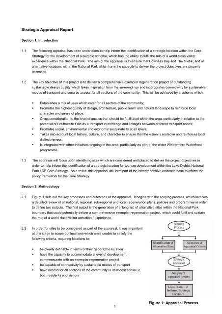
2.1 Figure 1 sets out the key processes and outcomes of the appraisal. It begins with the scoping process, which involves<br />
a detailed review of all national, regional, sub-regional and local regeneration plans, policies and programmes in order<br />
to define two outputs. The first output is the generation of a ‘long list’ of alternative sites within the <strong>National</strong> <strong>Park</strong><br />
boundary that could potentially deliver a comprehensive exemplar regeneration project, which could fulfil and sustain<br />
the role of a world class visitor attraction / experience.<br />
2.2 In order for sites to be considered as part of the appraisal, it was important<br />
at this stage to scope out locations which were unable to satisfy the<br />
following criteria, requiring locations to:<br />
• be clearly definable in terms of their geographic location<br />
• have the capacity to accommodate a level of development<br />
commensurate with an exemplar regeneration project<br />
• be capable of connectivity by sustainable modes of transport<br />
• have access for all sections of the community in its widest sense i.e.<br />
both residents and visitors<br />
1<br />
Figure 1: <strong>Appraisal</strong> Process
2.3 The second output is the appraisal criteria that will be used to assess the suitability of these alternative attractions in<br />
fulfilling a world class visitor destination. The list of sites and appraisal criteria have been incorporated into an<br />
appraisal matrix, which will be used to identify those sites, which are considered well placed to develop an exemplar<br />
regeneration project that fulfils the objectives outlined in paragraph 1.2.<br />
2.4 Each site will be scored against the appraisal criteria on the basis that it has either a strongly negative impact (minus 2<br />
points), a negative impact (minus 1 point), a neutral impact (no points), a positive impact (1 point) or strongly positive<br />
impact (2 points). Certain criteria are also weighted in order to place more emphasis on those criteria which are<br />
considered critical in view of the requirements and priorities of key policies of relevance to sustainable tourism<br />
development as outlined in section 3.<br />
Scoring System<br />
Impact<br />
Score<br />
A strongly negative impact -- -2<br />
A negative impact - -1<br />
A neutral impact 0 0<br />
A positive impact + 1<br />
A strongly positive impact ++ 2<br />
2.5 The higher scoring sites are those which are most likely to sustain a world class attraction / experience.<br />
Section 3: Scoping<br />
Selecting Alternative Sites<br />
3.1 The scoping process has involved an in depth review of the following plans/strategies and programmes to identify<br />
sites, priorities and development principles:<br />
• Regional Economic Strategy<br />
• <strong>Lake</strong> <strong>District</strong> Economic Futures Policy Statement<br />
• North West of England Plan Regional Spatial Strategy<br />
• Joint Cumbria and <strong>Lake</strong> <strong>District</strong> Structure Plan<br />
• Cumbria Tourism Management Plan<br />
• <strong>Lake</strong> <strong>District</strong> <strong>National</strong> <strong>Park</strong> Core Strategy Preferred Options Consultation Draft<br />
• Vision for <strong>Lake</strong> <strong>District</strong><br />
• Windermere and Bowness Enhancement Masterplan<br />
• Ambleside and Waterhead <strong>Strategic</strong> Masterplan<br />
• Waterhead Feasibility Study<br />
• Keswick Masterplan<br />
2
3.2 This has led to the identification of 12 potential sites, which form the ‘long list’ of alternative locations to be appraised.<br />
These sites are described in greater detail in the table below.<br />
1. Bell Close, Otley<br />
Road and Central<br />
Car <strong>Park</strong>s, Keswick<br />
Site Location<br />
Bell Close, Otley Road and Heads Road, Keswick Town Centre<br />
Site Description<br />
As detailed in the Keswick Town Centre Masterplan, the clearance of sites in the town<br />
centre – including the former abattoir and the gas works as well as business premises<br />
to the north of Market Place – has enabled the construction of Bell Close and Otley<br />
Road car parks.<br />
Bell Close is centrally placed and feels part of the town centre, with active uses<br />
developing along its edges. There is convenient but neglected passageway and lane<br />
access to Market Square. Bell Close functions as a social space; it is visually<br />
unattractive but with great potential for improvement.<br />
The Otley Road car park is in a back land location separated from the town centre by<br />
Victoria Street and is too concealed to be completely comfortable or sociable.<br />
Central Car <strong>Park</strong> at Heads Road appears to have been created by site clearance and<br />
demolition, although this is not the case. The car park contains some mature trees and<br />
there are numerous links through lanes up to the town centre, but it does not feel like an<br />
integral part of the town centre in the same way as Bell Close. Work is required to make<br />
it a more sociable space but remoteness from the Market Place may militate against<br />
this.<br />
The masterplan proposes:<br />
• Bell Close Car <strong>Park</strong> and Otley Road Car <strong>Park</strong> - conversion of the Crown Court<br />
building into a gallery / retail / workspace, new underground car park, new public<br />
space and mixed development retail / residential /workspace.<br />
• Central Car <strong>Park</strong> - Two blocks of mixed use development at the east and west ends<br />
of the car park each containing a mix of retail, leisure, space for micro-businesses<br />
and residential, construction of underground and/or concealed car parking using the<br />
natural level differences across the site (north to south) and a central pedestrian<br />
priority space or square for performances, events and commercial promotions which<br />
can also be used for car parking.<br />
(Source: Keswick Town Centre Masterplan, November 2006)<br />
2. Bowness Bay & The<br />
Glebe Masterplan<br />
Site Location<br />
Bowness-on-Windermere<br />
Site Description<br />
An exemplar regeneration project to provide for the comprehensive redevelopment of<br />
the <strong>Lake</strong> Windermere frontage, together with improve traffic management, improved<br />
public access to the lake shore and a strengthening of the role of the Glebe public<br />
space.<br />
(Source: Bowness Bay and the Glebe Masterplan, BDP, May 2009)<br />
3
3. Brockholes Visitor<br />
Centre<br />
Site Location<br />
The Visitor Centre is located between Windermere and Ambleside off the A591.<br />
<strong>Lake</strong> <strong>District</strong> Visitor Centre at Brockhole, Windermere, Cumbria LA23 1LJ.<br />
Site Description<br />
The <strong>National</strong> <strong>Park</strong> Visitor Centre which is owned by the <strong>Lake</strong> <strong>District</strong> <strong>National</strong> <strong>Park</strong><br />
Authority was opened in 1969, and is set in 30 acres of terraced gardens stretching<br />
down to the shore of Windermere, with splendid views of the surrounding countryside.<br />
The centre currently comprises an adventure playground, lakeside setting, exhibitions,<br />
fabulous gardens, information centre, gift shop and cafe and a pay and display car park.<br />
There is also the Brockhole Jetty. In recognition of the potential of the site, there are<br />
already plans in place to develop the centre into a world class visitor attraction.<br />
(Source: <strong>Lake</strong> <strong>District</strong> <strong>National</strong> <strong>Park</strong> Website)<br />
4. Derwentwater<br />
Foreshore Scheme<br />
Site Location<br />
North Eastern edge of Derwent Water near to Keswick Town Centre along the extent of<br />
<strong>Lake</strong> Road.<br />
Site Description<br />
This project aims to improve physical and intellectual access to one of the UK's premier<br />
landscapes by conserving the environment of the Derwentwater Foreshore, treating<br />
natural erosion and managing high-volume use. The built and natural environment will<br />
be regenerated to maximise the potential of the high quality landscape and improve<br />
circulation/seating/resting area provision. The project will restore the site as a high<br />
quality recreation area linked to the natural assets of an exceptional landscape setting<br />
and the approach to 'Friar's Crag'. The design scheme is based on three areas;<br />
• Activity area - at the foreshore embarkation point to facilitate heavy pedestrian use;<br />
• Transition area - a lower intensity of use; and a<br />
• Naturalised area - on land owned by the <strong>National</strong> Trust. Here access to the<br />
lakeshore will not be formalised and there will be a minimum of hard surfacing.<br />
Overall the scheme aims to tackle footpath and shoreline erosion and to refurbish lowgrade<br />
patched asphalt with sympathetic materials capable of withstanding the impact of<br />
millions of visitors and resolve conflict of interest arising from commercial and vehicular<br />
use of the site. It is proposed to improve and upgrade the facilities on site in such a way<br />
as to minimise the possibility that they may detract from the impact of the landscape<br />
itself whilst at the same time improving the safety of the site and providing for greater<br />
physical access.<br />
(Source: Allerdale Borough Council)<br />
5. Grizedale Forest<br />
<strong>Park</strong><br />
Site Location<br />
Grizedale is located to the west of Windermere and to the east of Coniston Water. The<br />
two service centres of Coniston and Hawkshead are situated to the north of Grizedale.<br />
Site Description<br />
The Grizedale Forest <strong>Park</strong> covers an area of 2500 ha of forest and farmland, which is<br />
owned and managed by the Forestry Commission. In addition to being managed as a<br />
working forest, there are also a range of facilities for the benefit and enjoyment of<br />
visitors to Grizedale these include:<br />
• Visitors Centre with Forest Shop and Information Centre, an exhibition about the<br />
forest, its wildlife and history<br />
4
• Pay and display car parks (including parking for users with disabilities)<br />
• Public toilets<br />
• Forest tea room<br />
• A children’s play area with a wildlife theme<br />
• Covered picnic area for groups and individuals<br />
• Grizedale Hostel available to rent by groups<br />
• Forest Discovery Centre/classroom for hire to schools or other groups<br />
• 21 miles of waymarked walking trails (12 waymarked trails and picnic areas)<br />
• 38 miles of waymarked cycling trails (5 cycle trails)<br />
• A permanent orienteering course with 7 pre-designed routes<br />
• Grizedale Forest Sculpture Trail (home to 80 pieces of sculpture)<br />
• A forest campsite run by the Camping and Caravan Club (summer only)<br />
• Forest Education Service-run by rangers to cater for all types of groups<br />
(Source: Forestry Commission www.forestry.gov.uk/pdf/CSGriz.pdf/$FILE/CSGriz.pdf)<br />
6. Honister Slate Mine<br />
Site Location<br />
Honister Slate Mine,<br />
Honister Pass, Borrowdale, Keswick, Cumbria, CA12 5XN<br />
Site Description<br />
The Honister Slate Mine is a group of slate mines and quarries located at the top of the<br />
Honister Pass, which is now one of the last Working Mines in the <strong>Lake</strong> <strong>District</strong>. There is<br />
currently a visitor centre, café, gift shop and showroom, with underground tours<br />
organised on a daily basis. There is also parking for cars and mini buses. There is also<br />
a Via Ferrata, an adventure climbing system at Honister.<br />
7. Backbarrow Motor<br />
Museum<br />
This site is on the bank of the River Leven at Backbarrow near Newby Bridge, and<br />
makes use if the former Blue Mill carton packaging sheds.<br />
The new home for the <strong>Lake</strong>land Motor Museum which is due to open in Spring 2010 will<br />
become an important visitor destination. Improved transport links via a new rail halt at<br />
Backbarrow will consolidate its role and link it in to a more sustainable transport<br />
network.<br />
<strong>Lake</strong>side/Fell Foot<br />
Fell Foot <strong>Park</strong>, Newby Bridge, Ulverston<br />
The redevelopment of the Windermere <strong>Lake</strong> Cruises terminus, improvements to the<br />
surrounding public realm together with improvements to the <strong>Lake</strong>side Hotel offers an<br />
opportunity to create a high quality visitor node at the southern tip of <strong>Lake</strong> Windermere,<br />
befitting the spectacular landscape about it. Fell Foot the Victorian park on the eastern<br />
shore should form part of this visitor attraction.<br />
Haverthwaite<br />
Railway Terminal<br />
Haverthwaite railway terminal is located on the A590 near to Newby Bridge.<br />
Haverthwaite railway is a visitor destination in its own right and could be consolidated<br />
further. Originally this branch line of the Furness Railway carried passengers and<br />
freight from <strong>Lake</strong>side to Ulverston and Barrow, then south to Lancashire. This was<br />
closed by British Rail in the 1960's, and now the only part remaining is the 3.5 miles<br />
from Haverthwaite, through Newby Bridge to the terminus at <strong>Lake</strong>side. The<br />
Haverthwaite Railway Terminal offers refreshments and a railway gift shop. Potentially<br />
it could also be a southern entry to <strong>Lake</strong> Windermere, its attractions and the <strong>National</strong><br />
<strong>Park</strong>, including as a park and ride connection to the Grizedale Forest Visitor Centre.<br />
5
8. Keswick Pencil Mill<br />
Site Location<br />
Southey Works, Greta Bridge,<br />
Keswick, Cumbria, CA12 5NG<br />
Site Description<br />
The Pencil Factory was a major employment land use and a local landmark in Keswick<br />
up until early 2008 when the Cumberland Pencil Company relocated to the Lillyhall<br />
Industrial estate near Workington. This site now comprises a redundant three storey<br />
mill building and associated land close to the centre of Keswick with a riverside setting,<br />
although the Pencil museum is still operational in the south east corner of the site. The<br />
entire site is located within a flood zone 3a (high risk).<br />
(Source: Keswick Town Centre Masterplan, November 2006 / Employment Sites<br />
Programme, November 2008)<br />
9. Lowther Castle and<br />
Gardens, near<br />
Askham<br />
Site Location<br />
Lowther Castle and Gardens are located at the Northern edge of the <strong>Lake</strong> <strong>District</strong><br />
<strong>National</strong> <strong>Park</strong>, 3 miles from junction 40 of the M6, providing an gateway into the<br />
<strong>National</strong> <strong>Park</strong>.<br />
Site Description<br />
This 133 acre, Grade II* listed site contains the remnants of at least three significant<br />
buildings and much of its 17th century gardens remains intact. The grounds were once<br />
opened to visitors in 1938 but after being used to test a secret tank weapon during the<br />
Second World War, the place was deliberately dismantled and abandoned. The Castle<br />
and its Gardens have been closed for 70 years and now stand inaccessible and buried<br />
in vegetation. The <strong>Lake</strong>land Bird of Prey Centre is also situated within the walled<br />
garden of Lowther Castle.<br />
Lowther Gardens and Castle has been identified as a major project by Cumbria Vision<br />
in its Economic Plan and is a priority project for Cumbria Tourism. The Trustees of the<br />
Lowther Castle and Gardens Trust plan to transform the imposing remains of the Gothic<br />
Castle, its massive stables and over 20 hidden gardens into a unique visitor destination.<br />
A masterplan has already been created for the site and it is intended that plans will be<br />
implemented over three years, with the first phase planned to open in Summer 2009.<br />
The finished scheme will create a visitor centre in the stables next to the Castle which<br />
will be free to access. The visitor centre will offer shopping, eating, education and<br />
orientation facilities, including a 1,500 seat amphitheatre. The ruined Castle will be<br />
stabilised and spectacular access will be provided to its central staircase tower. Over<br />
121 acres of abandoned gardens will be gradually renovated. A children's play area will<br />
be built in the woods.<br />
(Source: Lowther Gardens and Castle Development Plan September 2008,<br />
www.transforminglowther.co.uk/ )<br />
10. Waterhead on<br />
Windermere<br />
Site Location<br />
Waterhead is located on the northern edge of <strong>Lake</strong> Windermere, close to the town of<br />
Ambleside.<br />
6
Site Description<br />
A programme of physical regeneration to improve the quality of public realm design and<br />
parking and create a more welcoming and improved lakeside experience, including<br />
creation of a ‘new‘ gateway to Ambleside and a major recreation and leisure anchor to<br />
the central <strong>Lake</strong>s, rivalling anything Europe or the rest of the world has to offer, creation<br />
of a high quality and more generous pedestrian lakeside ‘cultural’ boulevard (with<br />
attractive beach, paving, lighting, seating, shelters, planting and sculptures at the head<br />
of <strong>Lake</strong> Windermere, creation a new enhanced junction together with an efficient treelined<br />
road link to relieve car congestion and improving pedestrian safety along <strong>Lake</strong><br />
Road, provision of significant mitigation to prevent risk of future flooding, improved<br />
mooring facilities, a larger, safer and easier to maintain car park accessible from <strong>Lake</strong><br />
Road, new shops and residential development, a cultural arts or food market, new<br />
improved views for both pedestrians and car passengers, improved pedestrian links,<br />
improved landing facilities to the Wateredge Inn with possible Steam Boat access, new<br />
improved toilet facilities and water features.<br />
11. Wellbank Camp,<br />
Bootle<br />
Site Location<br />
This site is located just out of Bootle but the site is considered to be well related to the<br />
village, and the site is also well related to Hycemoor to the west of the site.<br />
Site Description<br />
This site is a former Ministry of Defence camp, which comprises redundant land and<br />
buildings apart from the swimming pool which is used by members of the local<br />
community. This site is identified as being suitable for mixed use development including<br />
an element of residential development.<br />
(Source: Employment Sites Programme, November 2008)<br />
12. Windermere<br />
Steamboat Museum<br />
Site Location<br />
Windermere Steamboat Centre<br />
Located on Rayrigg Road, Windermere, LA23 1BN.<br />
Site Description<br />
The Windermere Steamboat Centre is home to a collection of 15 historic steam and<br />
motor boats in a covered setting on <strong>Lake</strong> Windermere. The site offers parking,<br />
tearoom, shop, picnic area and there are stream launch trips are offer.<br />
The <strong>Lake</strong>land Arts Trust have embarked on a project to redevelop the Windermere<br />
Steamboat Museum. This will involve a major overhaul of the collection and complete<br />
rebuild of the museum complex which currently houses the internationally important<br />
collection of boats, which are a key part of Windermere’s heritage.<br />
(Source: www.lakelandartstrust.org.uk/steamboat/)<br />
7
Defining <strong>Appraisal</strong> Criteria<br />
3.3 The second output of the scoping process has been to define the criteria for the appraisal. The criteria are based on<br />
an interpretation of key policies of relevance to sustainable tourism development in the <strong>Lake</strong> <strong>District</strong>. The sources of<br />
reference are referred to in more detail below.<br />
3.4 The ‘Vision for the <strong>National</strong> <strong>Park</strong> in 2030’ adopted by the <strong>Lake</strong> <strong>District</strong> <strong>National</strong> <strong>Park</strong> Partnership is the agreed<br />
mechanism for the development of Local Development Framework plans and policies. It thus provides a particularly<br />
appropriate set of headline principles in which to assess the suitability of proposed strategic sites, so that they help<br />
achieve the statutory processes of the <strong>National</strong> <strong>Park</strong>, which are:<br />
• To conserve and enhance the natural beauty, wildlife and cultural heritage of <strong>National</strong> <strong>Park</strong>s; and<br />
• To promote opportunities for the understanding and enjoyment of the special qualities of the <strong>National</strong> <strong>Park</strong>s by<br />
the public.<br />
3.5 The four key elements of the vision have formed the main structure of the appraisal matrix, which will review project<br />
proposals under the same key headings of ‘A prosperous economy,’ ‘World class visitor experiences,’ ‘vibrant<br />
communities,’ and ‘Spectacular landscape.’ Indeed, the appraisal is informed by some of the key delivery aims, which<br />
will be used to test each proposal:<br />
• A prosperous economy: Businesses will locate in the <strong>National</strong> <strong>Park</strong> because they value the quality of<br />
opportunity, environment and lifestyle it offers – many will draw on a strong connection to the landscape.<br />
Entrepreneurial spirit will be nurtured across all sectors and traditional industries maintained to ensure a diverse<br />
economy.<br />
o Connect the special qualities of the <strong>National</strong> <strong>Park</strong>, including landscape features and cultural heritage, to the<br />
economy through imaginative approaches.<br />
o Maximise the opportunities for the <strong>National</strong> <strong>Park</strong> to support the regeneration of Cumbria and wider regional<br />
or national initiatives.<br />
• World class visitor experiences: High quality and unique experiences for visitors within a stunning and globally<br />
significant landscape. Experiences that compete with the best in the international market.<br />
o Promote a welcoming <strong>National</strong> <strong>Park</strong> to the world as part of the wider regeneration of Cumbria.<br />
o Enhance the quality and diversity of the visitor’s experience through improvements to accommodation,<br />
attractions and visitor facilities.<br />
o Offer a unique, varied and memorable visit.<br />
o Encourage visitors to stay longer and spend more on local goods and services.<br />
o Celebrate what is special about the <strong>Lake</strong> <strong>District</strong> by promoting: its rich cultural heritage, local traditions, and<br />
products; and an appreciation of its spiritual value and sense of tranquillity.<br />
o Encourage young people to enjoy and value the <strong>Lake</strong> <strong>District</strong> so that they want to return in later life.<br />
o Engender local pride and responsibility, securing the long term sustainability of the special qualities of the<br />
<strong>National</strong> <strong>Park</strong>.<br />
• Vibrant communities: People successfully living, working and relaxing within upland, valley and lakeside places<br />
where distinctive local character is maintained and celebrated.<br />
o Enable the provision of an integrated transport network which offers attractive alternatives to the car.<br />
o Work to ensure that everyone understands and feels part of the <strong>National</strong> <strong>Park</strong>, and its cultural heritage, and<br />
can contribute to its future well-being.<br />
• Spectacular landscape: A landscape which provides an irreplaceable source of inspiration, whose benefits to<br />
people and wildlife are valued and improved. A landscape whose natural and cultural resources are assets to be<br />
managed and used wisely for future generations.<br />
o Ensure change strengthens the distinctiveness of the aquatic and land based localities of the <strong>National</strong> <strong>Park</strong>.<br />
o Promote innovative and high quality design which takes inspiration from its surroundings.<br />
8
o<br />
o<br />
Improve the quality of the built environment that people enjoy or use.<br />
Enable people to connect with nature and landscape – by improving access, understanding, enjoyment,<br />
education and health.<br />
3.6 The strategic objectives within the <strong>Lake</strong> <strong>District</strong> <strong>National</strong> <strong>Park</strong> LDF Core Strategy Preferred Options May 2008 also<br />
provide a useful point of reference for helping to define the appraisal criteria. These are based upon the same four key<br />
elements of the Vision for the <strong>National</strong> <strong>Park</strong> in 2030:<br />
Spectacular landscapes<br />
• SO1 Ensure development protects and enhances the environment, its wildlife, culture and Heritage<br />
• SO2 Recognise that different areas of the LDNP have a different capacity and ability to accommodate change<br />
• SO3 Enable development that secures the wealth of traditional skills and materials necessary to maintain the<br />
environment<br />
• SO4 Support change and development where it strengthens the distinctiveness of an area<br />
• SO5 Promote use of natural resources and minimise energy requirements of development to mitigate against the<br />
impact of climate change<br />
Prosperous economy<br />
• SO6 Encourage development of businesses which trade on a connection with the special qualities of the <strong>National</strong><br />
<strong>Park</strong><br />
• SO7 Support of development which transforms the economy of the <strong>National</strong> <strong>Park</strong> and Cumbria according to<br />
where it is needed<br />
• SO8 Provide opportunities and infrastructure for diversification and incubation of new business and future<br />
expansion by identifying needs and providing sites<br />
World-class visitor experiences<br />
• SO9 Enable development which ensures the diverse needs of visitors are met<br />
• SO10 Encourage the continued enhancement of the public realm in settlements<br />
• SO11 Support development which contributes to the infrastructure necessary to support sustainable tourism<br />
• SO12 Ensure accessibility to the spectacular landscape<br />
Vibrant communities<br />
• SO13 Enable development to meet the needs of the community, its safety and well-being<br />
• SO14 Encourage development in sustainable locations to support vibrant, rural Communities<br />
• SO15 Ensure high quality design and location within development that enhances the reputation of the area whilst<br />
supporting local character and distinctiveness, safety and well-being<br />
• SO16 Support regeneration which transforms communities at risk and protects community facilities or services<br />
• SO17 Provide new housing to support and maintain our vibrant communities, which is of a type and tenure<br />
appropriate to meeting the identified local need, is of a standard which helps to address the issue of climate<br />
change and is assessed in the context of other land use demands.<br />
3.7 Moving on to the wider policy framework, the North West of England Plan Regional Spatial Strategy (RSS) is<br />
significant in that it not only forms the ‘development plan’ to which development proposals are assessed, but it also<br />
provides the framework for sub-regional and local planning. Policies W6, W7 and CNL3 set out a number of<br />
development principles for the general development of tourism as well as the specific needs of the <strong>Lake</strong> <strong>District</strong>.<br />
These are abridged below and interpreted within the appraisal:<br />
• Development should be of an appropriate scale and be located where the environment and infrastructure can<br />
accommodate the visitor impact.<br />
9
• Sustainable tourism activity which will strengthen and diversify the economic base will be supported but the<br />
statutory purposes of these designations (<strong>National</strong> <strong>Park</strong>, Areas of Outstanding Beauty etc.) must not be adversely<br />
affected.<br />
• Plans and strategies should ensure high quality, environmentally sensitive, well-designed tourist attractions,<br />
infrastructure and hospitality services, which:<br />
o improve the region’s overall tourism offer, increasing the market share of attractions;<br />
o meet the needs of a diverse range of people and are easily accessible by sustainable means;<br />
o support the provision of distinct tourism resources that harness the potential of sites and their natural<br />
attributes, including built heritage and cultural facilities;<br />
o encourage and facilitate regeneration;<br />
o promote facilities which will extend the existing visitor season;<br />
o harness the potential of sport and recreation, particularly the role of major sporting events;<br />
o improve the public realm;<br />
o are viable in market and financial terms;<br />
o help to relieve pressure on locations vulnerable to the impacts of climate change;<br />
o respect the environmental sensitivity of the coast, particularly the undeveloped coast along with other<br />
sensitive areas, and ensure that the integrity of sites of international importance for nature conservation are<br />
maintained through assessment of proposals and through careful visitor management and restrictions on<br />
visitor access where necessary;<br />
o promote eco-tourism in areas of high natural value in a way that minimises any adverse effect on the natural<br />
assets that visitors seek to experience.<br />
• Plans and strategies should give priority to the protection of the landscape and cultural heritage of the <strong>Lake</strong><br />
<strong>District</strong> <strong>National</strong> <strong>Park</strong>. In addition they should:<br />
o promote further diversification and development of its economic base;<br />
o develop programmes for improvements to the public realm and effective traffic management in Windermere,<br />
Ambleside and Keswick, to enhance the urban fabric and support their recreational and tourism roles;<br />
o manage recreational and sustainable tourist activities, in suitable locations;<br />
o ensure that public transport services are improved and better integrated, and that the proportion of travel to<br />
and within the <strong>National</strong> <strong>Park</strong> by sustainable modes is increased;<br />
o and address the relationship of the <strong>National</strong> <strong>Park</strong> with its wider area, and develop a suitable framework for<br />
meeting locally generated needs.<br />
3.8 In addition to the RSS the Regional Economic Strategy (RES) outlines a series of ‘transformational actions’ that<br />
emphasise the needs and potential of the <strong>Lake</strong> <strong>District</strong> and which have informed the context of the appraisal<br />
(highlighted in italics). These are:<br />
• Transformational Action 56. Implement plans to ensure ongoing growth in the rural economy as part of the<br />
Regional Rural Delivery Framework<br />
• Transformational Action 101: Improve the product associated with the region’s tourism ‘attack brands’ and<br />
‘signature projects’ as identified in the Regional Tourism Strategy, in line with market demand (the <strong>Lake</strong> <strong>District</strong> is<br />
an ‘attack brand’ and the Renaissance of the <strong>Lake</strong> <strong>District</strong> a ‘signature project.’<br />
• Transformational Action 113. Develop the economic benefit of the region’s natural environment through better<br />
alignment of environmental activities and economic gain.<br />
• Transformational Action 115. Deliver sustainable growth through use of the region’s heritage environments and<br />
assets – especially… The <strong>Lake</strong> <strong>District</strong><br />
• Transformational Action 119: Invest in quality public realm, green space and environmental quality focused on…<br />
Tourism “Attack Brand” and “Signature Project” locations and key arrival points…<br />
3.9 One of the key Transformational Actions (TA) not mentioned above is TA 114, which outlines the implementation of the<br />
<strong>Lake</strong> <strong>District</strong> Economic Futures Policy Statement to secure the <strong>Lake</strong> <strong>District</strong>’s tourism offer and broaden its economic<br />
10
performance. The policy statement sets out the North West Development Agency’s position on the recommendations<br />
of the <strong>Lake</strong> <strong>District</strong> Economic Futures Study and will be used by the NWDA and partners as one of a number of<br />
resources to inform regional, sub-regional and local policy development. The central theme to emerge from this<br />
statement is to achieve a step-change in quality within the <strong>Lake</strong> <strong>District</strong>. This means securing an outstanding natural<br />
environment, a superb food and accommodation offer, a pristine public realm, increased standards of customer care,<br />
sharply improved urban design standards understanding and building on the distinctiveness of each of the towns, and<br />
premium local produce and retail and has been reflected in the appraisal.<br />
3.10 At the sub-regional level some polices of the Joint Cumbria and <strong>Lake</strong> <strong>District</strong> Structure Plan have been extended until<br />
replacement by a further review of the RSS. Policy EM16 is a saved policy and is particularly relevant as it refers to<br />
the development of tourism. Suitable criteria to be considered in the appraisal include:<br />
• New tourism facilities will be directed to key service centres and to locations that enable the economic and<br />
physical regeneration of an area, where they bring benefit to the local community.<br />
• Tourism development will be permitted where this does not prejudice Cumbria’s distinctive environmental, cultural<br />
and historic character and visitors’ enjoyment and understanding of it. The emphasis should be on sustaining<br />
these attributes and adding quality.<br />
• Tourism proposals in the <strong>Lake</strong> <strong>District</strong> <strong>National</strong> <strong>Park</strong> and AONBs will only be permitted where the statutory<br />
purposes of the designated areas are not contravened. In the <strong>Lake</strong> <strong>District</strong> <strong>National</strong> <strong>Park</strong> changes of use or<br />
conversions which result in the loss of important tourism accommodation or public amenities will not be permitted<br />
unless they are demonstrated to be unviable.<br />
• Tourism development within or affecting the <strong>Lake</strong> <strong>District</strong> <strong>National</strong> <strong>Park</strong> will only be permitted where:<br />
o it would not conflict with the special qualities of the <strong>National</strong> <strong>Park</strong> or diminish opportunities for quiet<br />
enjoyment,<br />
o it would not introduce inappropriate activities or levels of use, or otherwise be of a nature and scale<br />
detrimental to the character and quality of the environment, and<br />
o it would not result in the loss of serviced accommodation and of touring caravan pitches to other tourist<br />
uses.<br />
3.11 The appraisal criteria that have been used in the appraisal matrix are detailed below and links to the relevant plans and<br />
programmes that have helped to define the appraisal criteria and inform the weighting assigned to each criterion are<br />
identified.<br />
A Prosperous Economy<br />
1. Does the site have the capacity and ability to accommodate the level of change necessary to improve the<br />
region’s overall tourism offer, by increasing the market share of attractions and diversification of the economic<br />
base? (weight x3) (RSS Policies W7 and CNL3)<br />
2. Is the site well related to a rural service centre? (weight x3) (Joint Cumbria and <strong>Lake</strong> <strong>District</strong> Structure Plan Policy<br />
EM16)<br />
The thirteen Rural Service Centres which are identified in the Core Strategy Preferred Options document dated May<br />
2008 include:<br />
• Ambleside<br />
• Backbarrow<br />
• Bootle<br />
• Broughton-in-Furness<br />
• Caldbeck<br />
• Coniston<br />
11
• Gosforth<br />
• Grasmere<br />
• Glenridding / Patterdale<br />
• Hawkshead<br />
• Keswick<br />
• Staveley<br />
• Windermere / Bowness<br />
World Class Visitor Experiences<br />
3. Does the site have the potential to fulfil and sustain the role of a world class visitor attraction / experience?<br />
(weight x3)<br />
4. Does the site offer the opportunity to promote the area’s rich cultural heritage, local traditions, natural attributes<br />
and products? (weight x3) (Vision for the <strong>National</strong> <strong>Park</strong> in 2030)<br />
5. Does the site offer a high quality, unique, varied and memorable visitor experience? (Vision for the <strong>National</strong> <strong>Park</strong><br />
in 2030)<br />
Vibrant Communities<br />
6. Is the site well served by public transport links and could it increase travel to and within the <strong>National</strong> <strong>Park</strong> by<br />
sustainable modes? (weight x2) (RSS Policy CNL3)<br />
7. Does the site enable local people and visitors to connect with nature and landscape – by improving access to,<br />
understanding and enjoyment of and increasing educational and health benefits? (weight x2) (Vision for the<br />
<strong>National</strong> <strong>Park</strong> in 2030)<br />
Spectacular Landscape<br />
8. Is the site of an appropriate scale and located where the environment and infrastructure could accommodate the<br />
visitor impact? (weight x2) (RSS Policy W6)<br />
9. Will development of the site help to enhance the quality of the built environment and the public realm? (weight x2)<br />
(Vision for the <strong>National</strong> <strong>Park</strong> in 2030)<br />
10. Does the site relate well to the landscape and its special qualities and celebrate what is distinctive about the <strong>Lake</strong><br />
<strong>District</strong>? (Vision for the <strong>National</strong> <strong>Park</strong> in 2030)<br />
Explanation of Weighting Applied<br />
3.12 Certain criteria are also weighted in order to place more emphasis on those criteria during the appraisal. This section<br />
of the report provides further justification on the weightings applied.<br />
Criteria which have been assigned weighting x3<br />
1. Does the site have the capacity and ability to accommodate the level of change necessary to improve the<br />
region’s overall tourism offer, by increasing the market share of attractions and diversification of the economic<br />
base?<br />
2. Is the site well related to a rural service centre?<br />
3. Does the site have the potential to fulfil and sustain the role of a world class visitor attraction / experience?<br />
4. Does the site offer the opportunity to promote the area’s rich cultural heritage, local traditions, natural attributes<br />
and products?<br />
12
3.13 The greatest weighting has been applied to these criteria to reflect their importance in the appraisal. In determining a<br />
site’s suitability it is critical to ensure that the site has the sufficient capacity and ability to accommodate a scheme that<br />
has the potential to fulfil the role of a world class visitor attraction, in order to ensure that the project objectives can be<br />
satisfied, given that this is the principal reason for identifying a strategic location within the <strong>National</strong> <strong>Park</strong>.<br />
3.14 Given that the scheme will be developed as a world class attraction, it will be important that the site provides the<br />
opportunity to promote the area’s rich cultural heritage, local traditions, natural attributes and products, in order to<br />
create an attraction that is locally distinct and able to compete with the best in the international market.<br />
3.15 Ensuring that the site is within close proximity to the identified Rural Service Centres will be important to maximise<br />
opportunities for these centres to benefit from the multiplier effect generated from tourism development e.g. increased<br />
expenditure by visitors which will help to support the local economy, which will be of utmost importance. Also it will<br />
ensure that local people have the opportunity to benefit from any new jobs created associated with any such scheme.<br />
Criteria which have been assigned weighting x2<br />
6. Is the site well served by public transport links and could it increase travel to and within the <strong>National</strong> <strong>Park</strong> by<br />
sustainable modes?<br />
7. Does the site enable local people and visitors to connect with nature and landscape – by improving access to,<br />
understanding and enjoyment of and increasing educational and health benefits?<br />
8. Is the site of an appropriate scale and located where the environment and infrastructure could accommodate the<br />
visitor impact?<br />
9. Will development of the site help to enhance the quality of the built environment and the public realm?<br />
3.16 In addition to determining whether the site is physically able to accommodate change, it will be important to give due<br />
consideration to the environmental capacity of the site to ensure its long term sustainability.<br />
3.17 Also in order to ensure that the development is truly sustainable in the long term, it will be important that the site is<br />
easily accessible by sustainable modes of transport to ensure accessibility for all. This will also provide the opportunity<br />
to enable strong links to be created between other attractions and local facilities within the wider area.<br />
3.18 As set out within the project objectives, it will be important that the scheme promotes the highest quality of design,<br />
architecture, public realm and natural landscape to enhance the quality of the built environment and reinforce local<br />
character and sense of place.<br />
Section 4: <strong>Appraisal</strong> Results<br />
4.1 Overall as the table on page 14 reveals, the results of the strategic appraisal have shown that with the exception of the<br />
Honister Slate Mine site which scored 0, the remaining locations all scored positively. Out of a potential score of 44<br />
which was the maximum sites could be awarded through this appraisal process, only three sites achieved greater than<br />
50% of the total score which could be awarded. These sites include Bowness Bay & The Glebe Masterplan,<br />
Waterhead on Windermere and collectively the Backbarrow Motor Museum / <strong>Lake</strong>side/Fell Foot / Haverthwaite<br />
Railway Terminal sites. This demonstrates that these locations have the greatest capacity to accommodate change<br />
and would all therefore be well placed to develop an exemplar regeneration project that would provide a suitable tourist<br />
attraction, which would have the ability to fulfil the role of a world class visitor attraction.<br />
13
Alternative Sites<br />
<strong>Appraisal</strong> Criteria<br />
Bell Close, Otley Road and<br />
Central Car <strong>Park</strong>s, Keswick<br />
Bowness Bay & The Glebe<br />
Masterplan<br />
Brockhole Visitor Centre<br />
Derwentwater Foreshore Scheme<br />
(inc the Theatre by the <strong>Lake</strong>)<br />
Grizedale Forest <strong>Park</strong><br />
Honister Slate Mine<br />
Backbarrow Motor Museum<br />
<strong>Lake</strong>side/Fell Foot<br />
Haverthwaite Railway Terminal<br />
Keswick Pencil Mill<br />
Lowther Castle and Gardens,<br />
near Askham<br />
Waterhead on Windermere<br />
Wellbank Camp, Bootle<br />
Windermere Steamboat Museum<br />
A Prosperous Economy<br />
1. Does the site have the capacity<br />
and ability to accommodate the<br />
level of change necessary to<br />
improve the region’s overall<br />
tourism offer, by increasing the<br />
market share of attractions and<br />
diversification of the economic<br />
base? (weight x3)<br />
2. Is the site well related to a rural<br />
service centre? (weight x3)<br />
+ ++ + - + - + + ++ + + -<br />
3 6 3 -3 3 -3 3 3 6 3 3 -3<br />
++ ++ - + -- -- + ++ -- ++ + +<br />
6 6 -3 3 -6 -6 3 6 -6 6 3 3<br />
World Class Visitor Experiences<br />
3. Does the site have the potential to<br />
fulfil and sustain the role of a world<br />
class visitor attraction /<br />
experience? (weight x3)<br />
4. Does the site offer the opportunity<br />
to promote the area’s rich cultural<br />
heritage, local traditions, natural<br />
attributes and products? (weight<br />
x3)<br />
5. Does the site offer a high quality,<br />
unique, varied and memorable<br />
visitor experience?<br />
- ++ ++ + + - + + ++ + - +<br />
-3 6 6 3 3 -3 3 3 6 3 -3 3<br />
+ ++ ++ + + ++ + + ++ ++ - ++<br />
3 6 6 3 3 6 3 3 6 6 -3 6<br />
+ ++ + ++ + ++ ++ + ++ ++ - ++<br />
1 2 1 2 1 2 2 1 2 2 -1 2<br />
Vibrant Communities<br />
6. Is the site well served by public<br />
transport links and could it<br />
increase travel to and within the<br />
<strong>National</strong> <strong>Park</strong> by sustainable<br />
modes? (weight x2)<br />
7. Does the site enable local people<br />
and visitors to connect with nature<br />
and landscape – by improving<br />
access to, understanding and<br />
enjoyment of and increasing<br />
educational and health benefits?<br />
(weight x2)<br />
+ + + + - + + + - + + +<br />
2 2 2 2 -2 2 2 2 -2 2 2 2<br />
- ++ + ++ ++ + ++ - + ++ - +<br />
-2 4 2 4 4 2 4 -2 2 4 -2 2<br />
Spectacular Landscape<br />
8. Is the site of an appropriate scale<br />
and located where the<br />
environment and infrastructure<br />
could accommodate the visitor<br />
impact? (weight x2)<br />
9. Will development of the site help<br />
to enhance the quality of the built<br />
environment and the public realm?<br />
(weight x2)<br />
10. Does the site relate well to the<br />
landscape and its special qualities<br />
and celebrate what is distinctive<br />
about the <strong>Lake</strong> <strong>District</strong>?<br />
+ + + + + -- + + ++ 0 + +<br />
2 2 2 2 2 -4 2 2 4 0 2 2<br />
++ ++ + + + + + ++ ++ + ++ +<br />
4 4 2 2 2 2 2 4 4 2 4 2<br />
- ++ + ++ ++ ++ ++ - 0 ++ - +<br />
-1 2 1 2 2 2 2 -1 0 2 -1 1<br />
APPRAISAL TOTAL SCORE 15 40 22 20 12 0 26 21 22 30 4 20
Alternative Locations<br />
Score<br />
<strong>Appraisal</strong> Results<br />
Score expressed as<br />
% of total score (44) Ranking<br />
Bowness Bay & The Glebe Masterplan 40 91 1<br />
Waterhead on Windermere 30 68 2<br />
Backbarrow Motor Museum / <strong>Lake</strong>side/Fell Foot / Haverthwaite<br />
Railway Terminal<br />
26 59 3<br />
Brockhole Visitor Centre 22 50 4<br />
Lowther Castle and Gardens, near Askham 22 50 5<br />
Keswick Pencil Mill 21 48 6<br />
Derwentwater Foreshore Scheme (inc the Theatre by the <strong>Lake</strong>) 20 45 7<br />
Windermere Steamboat Museum 20 45 8<br />
Bell Close, Otley Road and Central Car <strong>Park</strong>s, Keswick 15 34 9<br />
Grizedale Forest <strong>Park</strong> 12 27 10<br />
Wellbank Camp, Bootle 4 9 11<br />
Honister Slate Mine 0 0 12<br />
4.2 The following section of this report draws out some of the positive and negative aspects that were identified through<br />
the appraisal for each of the sites.<br />
1. Bowness Bay & The Glebe Masterplan<br />
• Due to the area’s natural attributes and geographic location, this site is considered to have the qualities that<br />
would enable it to fulfil the role of a world class visitor experience.<br />
• This site overlooks <strong>Lake</strong> Windermere and Belle Isle and therefore enables visitors to enjoy the natural landscape<br />
and qualities that are distinctive to the <strong>Lake</strong> <strong>District</strong>.<br />
• This site is well related to a rural service centre.<br />
• It is located approximately 2 kilometres from Windermere Railway Station so there is the potential to strengthen<br />
public transport links to the site.<br />
• Development will help to significant enhance the quality of the existing public realm.<br />
2. Waterhead on Windermere<br />
• The site is situated within easy access of Ambleside which is identified as a rural service centre<br />
• The site is unlikely to have the environmental capacity to accommodate future change on a scale that would be<br />
necessary to create an attraction that has the potential to sustain the role of a world class attraction.<br />
• The area overlooks the northern shores of <strong>Lake</strong> Windermere and enables visitors to enjoy the natural qualities<br />
that are distinctive to the <strong>Lake</strong> <strong>District</strong>.<br />
• The area is currently accessible by public transport and as it is located approximately 5 miles from Windermere<br />
Railway Station there is the potential to strengthen public transport links to the area.<br />
3. Backbarrow Motor Museum / <strong>Lake</strong>side/Fell Foot / Haverthwaite Railway Terminal<br />
• Backbarrow is identified as a rural service centre.<br />
• A new rail halt at Backbarrow will help to improve sustainable transport links to these sites.<br />
• Development of these sites will help to enhance the quality of the public realm.<br />
• These sites are all situated close to the southern shores of <strong>Lake</strong> Windermere and will therefore allow people to<br />
easily connect with nature and the landscaping.<br />
14
4. Brockhole Visitor Centre<br />
• The site is not located within a rural service centre, however, Ambleside can be easily accessed from the A591.<br />
• The site is located on a bus route.<br />
• The site’s location and access to <strong>Lake</strong> Windermere enables local people and visitors to easily connect with<br />
nature.<br />
5. Lowther Castle and Gardens, near Askham<br />
• The scale of the site offers the capacity and ability to accommodate the level of change necessary to create an<br />
attraction that could potentially improve the region’s tourism offer, however as the site is located on the far<br />
eastern edge of the <strong>National</strong> <strong>Park</strong> any facility developed here would not be accessible to residents or visitors in<br />
the west of the <strong>Lake</strong> <strong>District</strong>.<br />
• The site is located approximately 6 miles south of Penrith off the A6. Although there are currently no existing<br />
public transport links to the site, there is the potential to improve links to Penrith railway station.<br />
• Development of the site will help to improve the quality of the built and natural environment given the site’s<br />
current largely desolate state.<br />
• The site offers the opportunity to promote the area’s cultural history.<br />
• The site is not located within easy access of any service centres.<br />
6. Keswick Pencil Mill<br />
• This site is located within short walking distance from Keswick town centre, an identified service centre.<br />
• As this site currently contains redundant buildings and associated land, development of this site is likely to<br />
enhance the quality of the built environment and the public realm.<br />
• This site could easily encourage increased levels of walking and cycling on account of its town centre location.<br />
• On account of its town centre location, this site is unlikely to enable people to connect well with nature and the<br />
natural landscape, although the site affords a riverside setting.<br />
7. Derwentwater Foreshore Scheme<br />
• The waterside location enables visitors to easily connect with nature and the landscape.<br />
• Its close proximity to Keswick town centre offers a varied and memorable experience for the visitor.<br />
• The area’s natural attributes help to create a high quality location that could fulfil the role of a world class<br />
attraction.<br />
8. Windermere Steamboat Museum<br />
• The site overlooks <strong>Lake</strong> Windermere and enables visitors to enjoy the natural landscape.<br />
• It is located approximately 1.5 kilometres from Windermere Railway Station so there is the potential to strengthen<br />
public transport links.<br />
• This site is easily accessible off the A592 which connects to the A591 the main route which connects Windermere<br />
to Ambleside and Waterhead.<br />
• The site’s natural attributes help to create a high quality location that offers a memorable visitor experience.<br />
• The site is unable to have the market capacity to accommodate the level of change necessary to improve the<br />
region’s overall tourism offer.<br />
15
9. Bell Close, Otley Road and Central Car <strong>Park</strong>s, Keswick<br />
• These car park sites are located in the heart of Keswick town centre, an identified service centre.<br />
• Collectively these sites are unlikely to have the market capacity to fulfil and sustain the role of a world class visitor<br />
attraction / experience.<br />
• On account of their town centre location, these sites are unlikely to enable people to connect well with nature and<br />
the natural landscape.<br />
• Given their current use as car parking areas, development of these sites is likely to significantly enhance the<br />
quality of the built environment and the public realm.<br />
• There is the potential to encourage increased levels of walking and cycling within the town centre.<br />
10. Grizedale Forest <strong>Park</strong><br />
• This site covers an area of 2500 ha of conifer forest and farmland so will enable local people and visitors to easily<br />
connect with nature and the local landscape.<br />
• As the site is managed as a working forest by the Forestry Commission it provides the opportunity to promote<br />
local traditions and provide educational benefits for the community.<br />
• Whilst the site is served by a rural shuttle bus, its location is quite remote from the existing centres of population<br />
so would not serve to effectively increase travel by sustainable modes.<br />
• The site is situated well outside of any of the identified service centres.<br />
11. Wellbank Camp, Bootle<br />
• This site is well related to Bootle, which is identified as a rural service centre.<br />
• The site itself is located on a ‘B’ road and there is no footpath to Bootle or Hycemoor from the site, and no bus<br />
route within 500 metres of the site, however, it is approximately 1km from the railway station at Hycemoor which<br />
is on the west cost mainline so there is the potential to strengthen public transport links to the site.<br />
• As the site contains redundant buildings and associated land, development of this site is likely to enhance the<br />
quality of the built environment and the public realm.<br />
• Whilst this site is of an appropriate scale and likely to have the environmental capacity to accommodate the<br />
visitor impact, on account of its geographic location on the far western edge of the <strong>National</strong> <strong>Park</strong> it would not be<br />
particularly accessible to residents or visitors travelling from the east of the <strong>Lake</strong> <strong>District</strong>.<br />
12. Honister Slate Mine<br />
• The site is not located within a rural service centre.<br />
• This site is served by a bus route.<br />
• This site offers the opportunity to promote the area’s natural attributes.<br />
• This site is unlikely to have the environmental capacity to accommodate the degree of change necessary to<br />
transform the site into a world class visitor attraction.<br />
• Further development of this site could potentially have a detrimental impact on the natural landscape but would<br />
enhance the quality of the existing public realm.<br />
16


