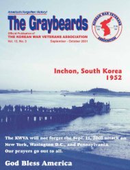
Sep/Oct 2005 - Korean War Veterans Association
Sep/Oct 2005 - Korean War Veterans Association
Sep/Oct 2005 - Korean War Veterans Association

Create successful ePaper yourself
Turn your PDF publications into a flip-book with our unique Google optimized e-Paper software.
70<br />
There is an adage that<br />
says “an army travels<br />
on its stomach!” Yep,<br />
an army must have food.<br />
Without food it cannot get<br />
very far; but,-an army must<br />
know where it is going to get<br />
that food. For that, they must<br />
have maps. If the army doesn’t<br />
know where it is going<br />
then what can it do?<br />
The 62nd Engineer<br />
Are We There Yet?<br />
TOPO MAPS<br />
By Roland Turley<br />
Topographic Company<br />
(Corp) left Fort Bragg, N.C.<br />
in early <strong>Sep</strong>tember 1950, and<br />
headed for the west coast-<br />
Oakland Army Base. We<br />
were ordered to report to<br />
Korea, since the <strong>Korean</strong> <strong>War</strong><br />
had started on June 25th<br />
1950 when the North <strong>Korean</strong>s invaded<br />
South Korea. We spent a few days at<br />
Oakland getting the necessary shots and<br />
indoctrination about the war we were<br />
headed for.<br />
For a bunch of “kids,” this was pretty<br />
much a case of the Army’s “hurry-up-andwait”<br />
game. But, we were given some<br />
training in how to get off a troop ship by<br />
way of the rope net ladders, one of the<br />
most miserable devices ever devised by<br />
man. As one steps down toward the next<br />
“rope-rung,” it moves away and causes<br />
one to slip and hang on for dear life. But,<br />
we managed to conquer the device and<br />
moved on to “bigger and better” things.<br />
Our ship, the General Patrick (why<br />
does the merchant marine name its ships<br />
after generals? Ships should be named<br />
after admirals), was loaded with 1,800<br />
troops, most of whom were “greener than<br />
grass.” (I know I was.) We sailed out of<br />
San Francisco Bay and under the Golden<br />
Gate Bridge on <strong>Sep</strong>tember 18th, 1950—<br />
and we were on our way to Korea.<br />
We entered Pusan Harbor on <strong>Oct</strong>ober<br />
3, 1950 and walked down a gangplank<br />
onto Asian soil. From there we were transported<br />
by 6 x 6 GMC trucks to a tent<br />
encampment right on the Pusan Bay.<br />
Between our tents and the bay was barbed<br />
wire on which the squid divers had hung<br />
their little squid to dry. Gad, what a<br />
stink!!! But, as the days moved on we<br />
became acclimated to that odor.<br />
For the next few days we received<br />
instructions on how to behave in that foreign<br />
culture. During our time in Pusan we<br />
attended a few classes designed to inform<br />
us about Asian culture. It was a failure, so<br />
we waited for our trucks and equipment to<br />
arrive at the docks in Pusan.<br />
While waiting, we were assigned to<br />
“native” pushing, i.e., supervising <strong>Korean</strong><br />
laborers in the unloading of cargo ships<br />
that came into Pusan Harbor. It was our<br />
job to see that whatever came off those<br />
ships was properly stored in the huge<br />
warehouses on the Pusan docks. After<br />
three weeks of this we were ordered to<br />
Seoul, Korea. We boarded our trucks and<br />
joined a large convoy headed for that city.<br />
As a lowly PFC, I rode in the open<br />
back of one of those 6 x 6s. On our way to<br />
Seoul, we ran into an ambush by North<br />
<strong>Korean</strong> guerillas. Our convoy was pinned<br />
down for several hours. As we waited—<br />
stalled in the early November sunlight—<br />
we watched as a “shave- tail-lieutenant”<br />
ordered his driver to get ahead of the convoy<br />
by fording a small stream. In the<br />
process, his jeep stalled in the stream. It<br />
was necessary to ask for help from a 6 x 6<br />
on the other side of that stream.<br />
As that 6 x 6 moved down the sandy<br />
bank of that stream, the left front wheel<br />
ran over a large anti-tank mine and blew<br />
two of the soldiers of that vehicle at least<br />
100 feet into the air. Both died instantly!!<br />
They were just young boys trying to do<br />
their job.<br />
We moved on after that traumatic experience,<br />
and headed for Seoul, where we<br />
were billeted in an old school house on the<br />
south side of the city. We set up<br />
our equipment and again began<br />
to produce the Tap MAPS that<br />
every service unit needed.<br />
Now, every GI knows what a<br />
Tap MAP is. It is a depiction of<br />
a portion of the earth’s surface.<br />
It shows roads, streams and<br />
rivers, railroad tracks, little<br />
square dots representing buildings,<br />
little “tufts” of grass representing<br />
swamps, and different<br />
colors representing other<br />
features.<br />
Producing these maps in the<br />
1950s was done primarily by<br />
hand, by following the features<br />
shown on aerial photos, and<br />
then “scaling” those features to<br />
represent accurate distances.<br />
An aerial photo, when taken from the<br />
proper altitude, will pretty much have a<br />
scale whereby an inch on the photo will be<br />
24,000 inches on the ground. Thus, the<br />
scale of 1” = 24 000”<br />
Photographs are on a flat piece of<br />
paper. So, they contain only two dimensions:<br />
length and width. However, the<br />
earth’s surface is in three dimensions:<br />
length, width and depth. By viewing two<br />
photos shot in close sequence through a<br />
pair of stereo lenses, the third dimension<br />
of depth or elevation can be seen and calculated<br />
mathematically. So, from these<br />
things come the beginnings of lines, colors<br />
and symbols on a piece of paper that<br />
we call a map. That was the job of the 62d<br />
Engineer Topographic Company (Corp)<br />
as attached to Eighth Army Hq. during its<br />
time in Korea.<br />
I was one of the cartographers. My job<br />
was to draw those lines on paper to produce<br />
the map. Later, that original was<br />
photographed and made into different<br />
metal plates for the “offset printing” system.<br />
The 62d Engr. Topo. Co. produced<br />
and printed many thousands of maps. In<br />
fact, during the first 6 months of our time<br />
in Korea, we printed and distributed over<br />
400,000 nine-color topographic maps of<br />
the peninsula of Korea. For this, and the<br />
manufacture of a 6 ft. x 8 ft. terrain model<br />
of the area around Pusan, our company<br />
received the Presidential Unit Citation;<br />
the laurel wreath proudly worn on our uniform<br />
sleeve.<br />
We stayed in Seoul for only four or five<br />
<strong>Sep</strong>tember - <strong>Oct</strong>ober <strong>2005</strong><br />
The Graybeards