

Document Title - Geoscience Australia
Document Title - Geoscience Australia
Document Title - Geoscience Australia

Create successful ePaper yourself
Turn your PDF publications into a flip-book with our unique Google optimized e-Paper software.
Lord Howe High Resolution Grids<br />
interpolated over leaving no null values. These gridding parameters had no significant increase in<br />
computation time.<br />
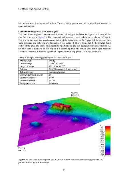
Lord Howe Regional 250 metre grid<br />
The Lord Howe regional 250 metre (or 9 second of arc) grid is shown in Figure 26. It uses all the<br />
data that is shown in Figure 25. The computational parameters used in Intrepid are shown in Table 4.<br />
The grid on this scale is a good representation of the bathymetry in the region. All the original data<br />
were honoured and only one gridding artefact was detected. This is located at the bottom left hand<br />
corner of the grid. The ship’s track seems to be a bit noisy and this has resulted in an oscillation. As<br />
no other data is available in that region it is something that will remain until better data becomes<br />
available. However, it is still a significant improvement of any grid so far at this resolution.<br />
Table 4: Intrepid gridding parameters for the ~250 m grid.<br />
PARAMETER<br />
VALUE<br />
Latitude range<br />
-32.85 o to -30.65 o<br />
Longitude range<br />
158.15 o to 160.35 o<br />
Cell size<br />
0.00225 degrees ( ~9 sec of arc)<br />
Cell assignment<br />
Nearest neighbour<br />
Minimum curvature tension 0.5<br />
Maximum iterations 2,000<br />
Maximum residual<br />
0.01 m<br />
Extrapolation limit<br />
2,000 cells<br />
30.65 o S<br />
160.35 o E<br />
32.85 o S<br />
158.15 o E<br />
Figure 26: The Lord Howe regional 250 m grid 2010 from this work (vertical exaggeration X 6,<br />
position marker approximate only).<br />
Depth in metres<br />
41


