

Document Title - Geoscience Australia
Document Title - Geoscience Australia
Document Title - Geoscience Australia

You also want an ePaper? Increase the reach of your titles
YUMPU automatically turns print PDFs into web optimized ePapers that Google loves.
Lord Howe High Resolution Grids<br />
3. Available Data<br />
BATHYMETRIC DATA<br />
A review of existing bathymetric data holdings at <strong>Geoscience</strong> <strong>Australia</strong> and a search for other<br />
bathymetric datasets that cover the Lord Howe Island region was undertaken. Only surveys that fell<br />
within the area bounded by the coordinates 158.15 o to 160.35 o E and 30.65 o to 32.85 o S were<br />
considered (Table 1). Basically four data types were found: singlebeam echosounder, multibeam<br />
echosounder (swath), satellite derived bathymetry and laser airborne depth sounder (LADS, also<br />
known as LIDAR). The history and characteristics of each dataset are described below.<br />
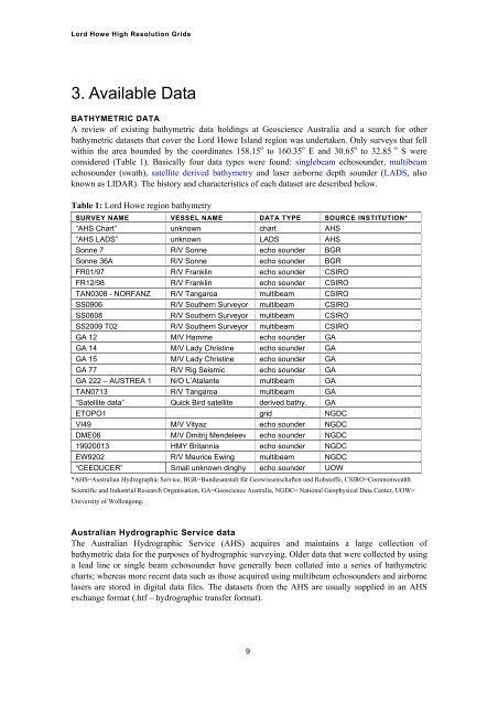
Table 1: Lord Howe region bathymetry<br />
SURVEY NAME VESSEL NAME DATA TYPE SOURCE INSTITUTION*<br />
“AHS Chart” unknown chart AHS<br />
“AHS LADS” unknown LADS AHS<br />
Sonne 7 R/V Sonne echo sounder BGR<br />
Sonne 36A R/V Sonne echo sounder BGR<br />
FR01/97 R/V Franklin echo sounder CSIRO<br />
FR12/98 R/V Franklin echo sounder CSIRO<br />
TAN0308 - NORFANZ R/V Tangaroa multibeam CSIRO<br />
SS0906 R/V Southern Surveyor multibeam CSIRO<br />
SS0608 R/V Southern Surveyor multibeam CSIRO<br />
SS2009 T02 R/V Southern Surveyor multibeam CSIRO<br />
GA 12 M/V Hamme echo sounder GA<br />
GA 14 M/V Lady Christine echo sounder GA<br />
GA 15 M/V Lady Christine echo sounder GA<br />
GA 77 R/V Rig Seismic echo sounder GA<br />
GA 222 – AUSTREA 1 N/O L’Atalante multibeam GA<br />
TAN0713 R/V Tangaroa multibeam GA<br />
“Satellite data” Quick Bird satellite derived bathy. GA<br />
ETOPO1 grid NGDC<br />
VI49 M/V Vityaz echo sounder NGDC<br />
DME06 M/V Dmitrij Mendeleev echo sounder NGDC<br />
19920013 HMY Britannia echo sounder NGDC<br />
EW9202 R/V Maurice Ewing multibeam NGDC<br />
“CEEDUCER” Small unknown dinghy echo sounder UOW<br />
*AHS=<strong>Australia</strong>n Hydrographic Service, BGR=Bundesanstalt für Geowissenschaften und Rohstoffe, CSIRO=Commonwealth<br />
Scientific and Industrial Research Organisation, GA=<strong>Geoscience</strong> <strong>Australia</strong>, NGDC= National Geophysical Data Center, UOW=<br />
University of Wollongong.<br />
<strong>Australia</strong>n Hydrographic Service data<br />
The <strong>Australia</strong>n Hydrographic Service (AHS) acquires and maintains a large collection of<br />
bathymetric data for the purposes of hydrographic surveying. Older data that were collected by using<br />
a lead line or single beam echosounder have generally been collated into a series of bathymetric<br />
charts; whereas more recent data such as those acquired using multibeam echosounders and airborne<br />
lasers are stored in digital data files. The datasets from the AHS are usually supplied in an AHS<br />
exchange format (.htf – hydrographic transfer format).<br />
9


