

Public Realm Design Manual
Public Realm Design Manual
Public Realm Design Manual

You also want an ePaper? Increase the reach of your titles
YUMPU automatically turns print PDFs into web optimized ePapers that Google loves.
<strong>Public</strong> <strong>Realm</strong> <strong>Design</strong> <strong>Manual</strong><br />
A Summary of District of Columbia Regulations<br />
and Specifications for the <strong>Design</strong> of <strong>Public</strong> Space Elements<br />
Government of the District of Columbia<br />
Vincent C. Gray, Mayor
Dear Neighbor,<br />
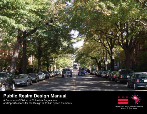
Majestic views of national monuments, leafy residential streets, and wide sidewalks in commercial areas... these are iconic<br />
images of Washington, DC. Much of the daily routine of District residents, workers, and visitors takes place in settings like<br />
these. This is where we walk to school, wait for the bus, talk to neighbors, walk the dog, window shop, or sit outside in a café<br />
to drink a cup of coffee. Having such an extensive network of public space enhances the quality of life for our residents and<br />
visitors, and ensures that the city has the foundation to become a more walkable and sustainable city.<br />
The District’s public space is a valuable asset worthy of our stewardship and - with the help of all residents and property<br />
owners - is one if the unique features that makes our city great. The Guide to the District of Columbia’s <strong>Public</strong> Space<br />
Regulations is a resource for learning about the importance of the District’s public space, the regulations that guide its use<br />
and form, and the rationale behind them. Property owners are required to maintain the public space adjacent to their<br />
property, so it is important that these ideas are understood clearly.<br />
Beginning with the L’Enfant Plan and continuing to today, Washington, DC has a notable history of using public space to<br />
define the city and give character and grace to neighborhoods. From inspirational views of the Capitol along leafy avenues<br />
to neighborhood networks of small green spaces, parks, schoolyards and recreation centers, to commercial boulevards with<br />
sidewalk cafes and street festivals – these defining characteristics of our public space are not the result of happenstance.<br />
Rather, it is the result of thoughtful planning, regulation and long-standing traditions of enhancing the public right-of-way.<br />
Today, the District Department of Transportation reviews approximately 6,000 public space permits annually to ensure that the<br />
interest of the public is protected.<br />
<strong>Public</strong> space contributes to the quality of life for everyone. It can only be maintained and enhanced with the help of all<br />
residents and property owners. Together we can maintain and improve this beloved public resource in a way that is<br />
environmentally responsible and that contributes to our everyday lives.<br />
Sincerely,<br />
Harriet Tregoning, Director<br />
DC Office of Planning<br />
Terry Bellamy, Acting Director<br />
DC Department of Transportation
TABLE OF CONTENTS<br />
INTRODUCTION<br />
1-1 1.1 The Importance of <strong>Public</strong> Space<br />
1-2 1.2 How to Use This Guide<br />
1-4 1.3 The <strong>Public</strong> Space Committee<br />
1-6 1.4 Important Definitions<br />
ROADWAYS<br />
2-1 2.1 Overview<br />
2-2 2.2 Policies And Regulations<br />
2-3 2.3 Streets<br />
2-3 2.3.1 Alignment Of New <strong>Public</strong> Streets<br />
2-3 2.3.2 Right-Of-Way Width<br />
2-3 2.3.3 Minor Streets<br />
2-5 2.3.4 Standard Roadway Elements<br />
2-7 2.4 Curbs and Gutters<br />
2.7 2.4.1 Standard Curbs<br />
2-7 2.4.2 Standard Gutters<br />
2-7 2.4.3 Federal Aid Streets, Historic Districts,<br />
And Special Districts<br />
2-9 2.4.4 Radius Standards For Driveways and Alleys<br />
2-10 2.5 Medians<br />
2-10 2.5.2 Width And Material Requirement<br />
SIDEWALKS<br />
3-1 3.1 Overview<br />
3-2 3.2 Policies<br />
3-3 3.3 Sidewalk <strong>Design</strong> Standards<br />
3-3 3.3.1 Sidewalk Width<br />
3-4 3.3.2 Grades And Slopes<br />
3-6 3.3.3 Materials<br />
3-8 3.4 Driveways<br />
3-8 4.4.1 Width<br />
3-9 3.4.2 Location<br />
3-9 3.4.3 <strong>Design</strong><br />
3-9 3.4.4 Number Of Driveways For Businesses<br />
3-9 3.4.5 Circular Driveways<br />
3-9 3.4.6 Grading<br />
3-10 3.4.7 Downtown Streetscape Driveway Regulation<br />
3-11 3.5 Sidewalk Cafes<br />
3-11 3.5.1 Furnishing And Fixtures<br />
3-12 3.5.2 Clear Sidewalk Space And Location<br />
3-13 3.5.3 Food And Serving Standards<br />
3-13 3.5.4 Additional Regulations For Enclosed Sidewalk Cafes<br />
3-14 3.5.5 Seating Capacity<br />
3-15 3.5.6 Additional Regulations For Unenclosed Sidewalk Cafes<br />
3-16 3.6 Street Trees<br />
3-16 3.6.1 Street Tree Spacing And Placement<br />
3-18 3.6.2 Tree Species Selection<br />
3-19 3.6.3 Treatment Of Tree Box Area<br />
3-20 3.6.4 Tree Box Beautification<br />
3-23 3.7 Bike Racks<br />
3-23 3.7.1 Placement<br />
3-24 3.7.2 <strong>Design</strong><br />
3-24 3.7.3 Installation<br />
3-24 3.7.4 Technical Consultation<br />
LANDSCAPING AND THE PUBLIC PARKING AREA<br />
4-1 4.1 Overview<br />
4-3 4.2 Policies<br />
4-4 4.3 Maintenance Responsibility<br />
4-4 4.4 <strong>Public</strong> Parking<br />
4-6 4.5 Fences<br />
4-6 4.5.1 Material and Height<br />
4-7 4.5.2 Location and Placement<br />
4-8 4.6 Retaining Walls And Grading<br />
4-8 4.6.1 Maintenance<br />
4-8 4.6.2 Retaining Walls<br />
4-8 4.6.3 Grading<br />
BUILDING PROJECTIONS<br />
5-1 5.1 Overview<br />
5-1 5.2 Policies<br />
5-1 5.3 General Regulations<br />
5-4 5.4 Subsurface Projections<br />
5-4 5.4.1 Areaways<br />
5-6 5.4.2 Vaults<br />
5-6 5.4.2.1 Uses<br />
5-6 5.4.2.2 Placement and Covers<br />
5-8 5.5 Above Ground Projections<br />
5-8 5.5.1 Balconies<br />
5-8 5.5.2 Bay Windows, Towers, Oriels, and Colonnades<br />
5-10 5.5.3 Porches<br />
5-11 5.5.4 Steps And Ramps<br />
5-12 5.5.5 Permanent Doors And Windows<br />
5-12 5.5.6 Awnings<br />
5-13 5.5.7 Canopies<br />
5-14 5.5.8 Marquees<br />
APPENDIX A
INTRODUCTION<br />
1.1 THE IMPORTANCE OF PUBLIC SPACE IN WASHINGTON, DC<br />
Washington, DC, has a long history of using public space to define its image. Beginning with<br />
the L’Enfant Plan, this image was characterized by wide streets with long views toward prominent<br />
buildings or open spaces. In 1870, Congress passed the “Parking Act” and designated part<br />
of the right-of-way immediately next to private property as park areas to be maintained by the<br />
adjacent property owner. This area was to be landscaped and is still referred to as “parking.”<br />
The following year, Congress passed the “Projection Act” that allowed bay windows, corner<br />
towers, and porches to project into public space.<br />
Grand avenues and boulevards are lined with<br />
landscaping and street trees that create long<br />
vistas toward parks and open space.<br />
<strong>Public</strong> space is a defining characteristic of the District and frames long views toward prominent buildings.<br />
During the late 19th and early 20th century, the District continued to develop public space<br />
regulations to protect long vistas along District streets, encouraged architectural variety, and<br />
required landscaped areas that create a “parkway” character. Today these regulations cover<br />
everything from the width of travel lanes to sidewalk cafes.<br />
<strong>Public</strong> space is a broad term that includes that area within the street right-of-way and can take<br />
on many different appearances. Typically thought of as the publicly owned area between private<br />
property lines, it includes the roadway, tree space, sidewalk, and often what appears to be<br />
1-1
front yards. Regulations for public space are also applied to private property within building<br />
restriction lines that define additional setbacks on some streets.<br />
The concept of park like landscaping in the District’s public right-of-way dates back to the<br />
nation’s Founding Fathers. In his first report to George Washington, surveyor Pierre L’Enfant<br />
outlined how to landscape his exceptionally wide avenues, specifying a landscape treatment<br />
for Pennsylvania Avenue, NW, between 1st and 16th Streets. Thomas Jefferson also proposed<br />
a system whereby D.C. streets would have tree-lined walkways on both sides. The dramatic<br />
change in the city during and immediately after the Civil War brought new impetus to improve<br />
public space. As part of an effort to improve the image of the nation’s capital and to reflect a<br />
unified, stable, and prosperous nation, a more formalized and strategic approach toward street<br />
management that included “public parking” was developed.<br />
Commercial areas in the District are defined by<br />
wide sidewalks, sidewalk cafes, and street trees.<br />
Residential neighborhoods in the District are easily<br />
recognized by generous landscaping and bay<br />
window projections.<br />
As the Civil War was winding down, local and federal leaders began moving toward a system<br />
that would transform public space. Both federal and local leaders advocated narrowing the<br />
“imperial widths” of District streets by converting parts of the right-of-way into parkland and<br />
giving the capital “a leading feature of rare beauty.” The framework for the parking system was<br />
established in the Parking Act of 1870. A second law dealing with public parking was passed in<br />
1872. It required property owners to maintain the public parking directly abutting their property<br />
while giving the property owner the exclusive right to enter that public space.<br />
Responding to desires for building projections into public parking, the municipal government<br />
declared in 1871 that it was “lawful to extend bay windows a distance of four feet beyond the<br />
building line” (underground vaults extending up to five feet into public space had been permitted<br />
since 1845). Although the primary purpose of public parking was for landscaping and greenery,<br />
projections were seen as a benefit to the public by allowing for architectural variation that added<br />
to the park-like character of streets and avenues. Buttressed by landscaped corridors, the<br />
projections enabled natural light and fresh air to radiate into homes, significantly enhancing<br />
quality of life. These projections, immediately popular, became an iconic part of Washington’s<br />
neighborhoods.<br />
In 1898 in a bill that reaffirmed public parking as part of the District’s park system, Congress<br />
transferred oversight of parking areas to the local government. Soon thereafter, regulations<br />
were developed that allowed adjoining landowners a broader range of improvements, including<br />
height and permeability of fences and hedges, that could be made in the parking area.<br />
Improvements in the public parking were processed through the regular permitting division of<br />
the city’s licensing department. Today they are processed by the <strong>Public</strong> Space Management<br />
Administration of the District Department of Transportation. A <strong>Public</strong> Space Committee was<br />
formed around 1941 to “protect the interest of the District of Columbia.” It still reviews certain<br />
types of public space applications.<br />
Today, wide streets with long vistas are still a defining characteristic of residential and<br />
commercial neighborhoods in the District and differentiate the city from surrounding jurisdictions.<br />
This image is the result of policies and regulations that few people are aware of but that many<br />
1-2
people benefit from. The impact they have on enhancing the transportation network and defining<br />
the image of the District is largely unappreciated.<br />
The way public space is used and designed impacts residents, workers, and visitors. Consistent<br />
application and enforcement of public space policies and regulations give our city a distinct<br />
character defined by open spaces and results in a greener and more walkable city.<br />
1.2 HOW TO USE THIS GUIDE<br />
This reference manual is a comprehensive review of the District’s public space policies and<br />
regulations. It will help business owners, developers, and residents better understand the<br />
appropriate use of public space, as well as assist government agencies that evaluate requests<br />
for waivers from public space regulations. Each regulation considered individually may appear<br />
insignificant; when considered together, these policies and regulations have a collective impact that<br />
is greater than the individual parts. For example, lowering a fence by a foot or making space for one<br />
street tree may seem to be a small detail. However, by understanding the intent behind Washington,<br />
DC’s public space regulations, it is possible to determine when deviations are appropriate.<br />
This dcoument is a supplement to the District’s <strong>Public</strong> <strong>Realm</strong> Handbook, which provides an<br />
introduction to the District’s goals for public spaces and general guidance on materials and<br />
components. It will allow District agencies and the public to develop plans and evaluate proposals<br />
that are consistent with District policies and regulations. Currently, these regulations are located in<br />
several documents and are not always easy to find. As presented here, policies and regulations from<br />
several documents are sorted by different public space components:<br />
1. DCMR Title 11: Zoning (DCMR-11)<br />
2. DCMR Title 12: Building Code (DCMR-12)<br />
3. DCMR Title 24: <strong>Public</strong> Space and Safety (DCMR-24)<br />
4. The Comprehensive Plan for the National Capital: District Elements (CP)<br />
5. DC Department of Transportation - <strong>Design</strong> and Engineering <strong>Manual</strong> (DEM)<br />
6. Downtown Streetscape Regulations (DSR)<br />
7. DC Department of Transportation – <strong>Public</strong> <strong>Realm</strong> <strong>Design</strong> Handbook (PRDH)<br />
The policies and regulations in the above documents are enforced city-wide. Area-specific<br />
guidelines, such as those developed for Mount Vernon Triangle or Great Streets, are not included.<br />
1-3
1.3 THE PUBLIC SPACE COMMITTEE<br />
The <strong>Public</strong> Space Committee makes final determinations on applications for various uses of public<br />
space and areas within building restriction lines. The Committee is responsible for assuring that the<br />
temporary and permanent uses of public space for public and private purposes are consistent with<br />
the laws and policies of the District government. The <strong>Public</strong> Space Committee is staffed by DDOT’s<br />
<strong>Public</strong> Space Management office and meets the 4th Thursday of every month.<br />
The Committee’s make-up and oversight authority has evolved since it was first established in 1939,<br />
responding to changes in the type of public space applications and issues facing the District. Today,<br />
it operates under a Mayoral Order that authorizes the Committee to make final determinations on the<br />
approval or denial of most applications for the temporary use of public space. The Committee is<br />
made up of five members representing four District agencies:<br />
1. Planning, Policy, and Sustainability Administration (DDOT), Chair;<br />
2. Transportation Operations Administration (DDOT);<br />
3. Department of Consumer and Regulatory Affairs;<br />
4. Office of Planning; and,<br />
5. Secretary of the District of Columbia.<br />
DCMR Title 24: <strong>Public</strong> Space and Safety, Chapter 1, broadly defines the review authority of the<br />
Committee to review and recommend to DDOT approval or denial of a public space application for<br />
a use that goes beyond what is allowed by existing regulations. It specifies that the Committee shall<br />
determine whether or not what is being requested will adversely affect the interest of the public or<br />
violate any of the following criteria:<br />
(a) The proposed additional use will not endanger the public;<br />
(b) The proposed additional use will not substantially interfere with pedestrian or vehicular traffic;<br />
and,<br />
Security bollards in public space must be<br />
approved by the <strong>Public</strong> Space Committee.<br />
(c) The proposed additional use will not increase the area of public space that the applicant for the<br />
permit is authorized to use by other law or regulation. (DCMR 12-100.1)<br />
1-4<br />
Other sections within DCMR Title 24 and DCMR Title 12: Building Code also identify specific public<br />
space applications that must be go before the Committee, as well as the criteria for review. The<br />
Committee makes the final determination to grant or deny public space applications for the following:<br />
• <strong>Public</strong> space rental permits. (DCMR 24-200, 201, 203, and 204)<br />
• Permits for sidewalk cafes. (DCMR 24-210, 301, and 305)<br />
• Permits for benches, trash receptacles, street furniture and amenities, and public art in the<br />
Downtown Streetscape Area. (DCMR 24-1108.1 and 1108.10)<br />
• Installation of markers by the Make a Difference Foundation in a location outside of the<br />
Downtown Streetscape Area. (DCMR 24 – 116.2(b))
• News media public space permits during an Inauguration. (DCMR 24-805.2)<br />
The Committee makes recommendations to grant or deny a permit issued by DCRA for the following:<br />
• Foregone construction in public space. (DCMR 12- 3202.4.2.5)<br />
• Signs for churches or non-profit institutions in public space. (DCMR 12-3107.9.5.4 and<br />
3107.9.5.5)<br />
• Refrigeration systems that extend beyond building restriction lines or into public space.<br />
(DCMR 12-120.2.2.1)<br />
Decisions of the <strong>Public</strong> Space Committee are final. The use of public space or the area beyond<br />
a building restriction line are considered a privilege and is not allowed by right. For additional<br />
information about the <strong>Public</strong> Space Committee, or to electronically receive <strong>Public</strong> Space Committee<br />
informational notices, send requests to: publicspace.committee@dc.gov. the Downtown Streetscape<br />
Area. (DCMR 24-1108.1 and 1108.10)<br />
Common public space applications that<br />
go before the <strong>Public</strong> Space Committee:<br />
• Overheight fences and retaining walls<br />
• Street furniture, like flag poles and<br />
benches<br />
• Statues and public art<br />
• Sidewalk cafes<br />
• Curb cuts<br />
• Security elements, like guard booths<br />
and bollards<br />
• Unusual projections<br />
• Signs for non-profit institutions<br />
• Non-standard light fixtures<br />
• Church bulletins<br />
Photo by M.V. Jantzen<br />
Non-standard light fixtures and public art must be approved by the <strong>Public</strong> Space Committee.<br />
1-5
1.4 IMPORTANT DEFINITIONS<br />
Understanding these terms and concepts is important for correctly interpreting the guidelines,<br />
standards, and regulations that apply to the District’s public space.<br />
Building Restriction Line: A required set-back a certain distance from the public right-of-way within<br />
which no building may take place and upon which the District’s public space regulations apply.<br />
Building Restriction Area: The space between the property line and building restriction line.<br />
Party Line Extended: Sometimes known as “property line extended” - the term “party line extended”<br />
means a line through the corners of the property and perpendicular to the street.<br />
Projection: Sometimes known as an “encroachment” - a structure that extends beyond a property line<br />
or building restriction line that is a privilege. Projections may not be claimed as a right, and require<br />
1-6
a permit. The building code establishes limitations on projections that may be granted. Proposed<br />
projections may be further restricted or refused if the code official determines such action best for the<br />
public interest.<br />
Property Line: The line delineating the boundaries of public space and private property.<br />
<strong>Public</strong> Parking Area: “<strong>Public</strong> Parking” means that area of public space devoted to open space,<br />
greenery, parks, or parking that lies between the property line, which may or may not coincide with the<br />
building restriction line, and the edge of the actual or planned sidewalk that is nearer to the property<br />
line, as the property line and sidewalk are shown on the records of the District. This area often<br />
includes spaces that appear to be front yards with private landscaping that create park-like settings<br />
on residential streets.<br />
“<strong>Public</strong> parking” is the area between the sidewalk<br />
and the property line devoted to open space<br />
and landscaping.<br />
Bay Projection<br />
Private Property<br />
<strong>Public</strong> Space<br />
Property Line<br />
<strong>Public</strong> Parking<br />
Sidewalk Area<br />
Tree Box/<br />
Furnishing Area<br />
1-7
<strong>Public</strong> Right-of-Way: The surface, the air space above the surface (including air space immediately<br />
adjacent to a private structure located on <strong>Public</strong> Space or in a <strong>Public</strong> Right-of-Way), and the area<br />
below the surface of any public street, bridge, tunnel, highway, lane, path, alley, sidewalk, or<br />
boulevard.<br />
<strong>Public</strong> Space: All the publicly-owned property between the property lines on a street, park, or other<br />
public property, as such property lines are shown on the records of the District, and includes any<br />
roadway, tree space, sidewalk, or parking between such property lines.<br />
Landscaped areas that appear to be the front yard<br />
of private homes are typically public space and<br />
part of the road right-of-way.<br />
Architectural projections such as porches provide<br />
visual variety in residential neighborhoods.<br />
The types of elements that are permitted in public space are closely tied to the adjacent land use.<br />
1-8
Sidewalks have distinct areas, which may include<br />
the tree box/furnishing area at the curb,<br />
“pedestrian clear zone,” and an area for sidewalk<br />
cafes or merchandise display.<br />
In some cases, private property is within a building restriction line where public space regulations apply.<br />
Tree Box/Furnishing Area: The area of the roadside that provides a buffer between the pedestrians<br />
and vehicles, which primarily contains landscaping such as a continuous planting strip in residential<br />
areas.<br />
Sidewalk Area: Sometimes known as the “pedestrian clear zone” – this is the walking zone on the<br />
sidewalk that must remain clear, both horizontally and vertically.<br />
1-9
ROADWAYS<br />
2.1 OVERVIEW<br />
Roadways play a significant role in the transportation network of the District. This section focuses<br />
on the elements between the curbs – the area devoted to vehicles and bicycles. The 1,100 miles<br />
of roadways in the District are categorized by function, ranging from interstates to local streets.<br />
A roadway classification has implications for the design of other elements in public space,<br />
including the type of material used for curbs and gutters and the width of tree boxes and sidewalks.<br />
The management of roadways takes into account<br />
the needs of multiple users.<br />
The management and design of the roadway must take into account the needs of a well-balanced<br />
and multi-modal transportation system that serves all businesses, visitors, and residents in the<br />
District. The efficient movement of pedestrians, cars, trucks, buses, and bicycles is integral to the<br />
city’s efforts to sustain and enhance the quality of life and is key to its future economic growth and<br />
its role as the Nation’s Capital.<br />
Medians slow traffic and provide a safe walkway<br />
for pedestrians at crosswalks.<br />
2-1<br />
The design of roadways accommodates a well balanced and multi-modal transportation system.<br />
Curbs, gutters, and medians are common elements of roadways. Curbs and gutters define the<br />
edge of the roadway dedicated to vehicular use and channel storm water to the sewer system. Their<br />
design and materials contribute to the function and appearance of public space. Medians, located<br />
in the center of the roadway, are intended to slow vehicular traffic, and provide a safe zone for<br />
pedestrians at crosswalks. They may be designed to include public art, trees, and landscape areas<br />
to enhance the street environment. The width of a median may vary depending on the width of the<br />
roadway, amount of traffic on the street, and proposed design.
2.2 POLICIES AND REGULATIONS<br />
The District’s policies and regulations for roadways are designed to create an infrastructure that<br />
safely accommodates a broad mix of vehicles into a network that covers the District.<br />
Comprehensive Plan<br />
Full text for these policies is on page A.<br />
• Policy T-1.1.3: Context-Sensitive Transportation<br />
• Policy T-1.1.4: Transit-Oriented Development<br />
• Policy T-2.1.4: Maintenance of Transit Facilities<br />
• Policy T-2.2.1: Multi-Modal Connections<br />
• Policy T-2.2.2: Connecting District Neighborhoods<br />
• Policy T-2.3.1: Better Integration of Bicycle and Pedestrian Planning<br />
• Policy T-2.4.1: Pedestrian Network<br />
• Policy T-2.4.2: Pedestrian Safety<br />
• Policy T-2.4.3: Traffic Calming<br />
• Policy T-2.5.1: Creating Multi-Modal Corridors<br />
• Policy T-2.5.2: Managing Roadway Capacity<br />
• Policy T-2.5.3: Road and Bridge Maintenance<br />
• Policy T-2.5.4: Traffic Management<br />
• Policy T-2.6.1: Special Needs<br />
• Policy T-2.6.2: Transit Needs<br />
• Policy T-4.1.3: Providing Redundancies<br />
Existing Roadway System<br />
Functional Classification:<br />
Principal Arterials<br />
Principal arterials, comprising 92 miles or<br />
approximately eight percent of the District’s<br />
roadway system, typically serve major activity<br />
centers and serve longer trip lengths than<br />
the roadway types listed below. The freeways<br />
and principal arterials function as the primary<br />
commuter routes and form the backbone of the<br />
overall roadway system. Freeways and principal<br />
arterials typically carry between 40 and 60 percent<br />
of a city’s total traffic volumes.<br />
Minor Arterials<br />
Minor arterials account for 173 miles, or<br />
approximately 15 percent of the total roadway<br />
system. These roadways serve short to medium<br />
length trips, with a greater emphasis on mobility<br />
than direct access. In a typical network, minor<br />
arterials make up 15 to 25 percent of the mileage<br />
and carry 15 to 40 percent of the total traffic.<br />
Collectors<br />
Collectors move traffic from local streets<br />
to arterials. Collectors will often intersect arterials at<br />
signalized intersections. Local roads will intersect<br />
collectors at stop signs. Collectors make up 152<br />
miles, or 13 percent, of the District’s roadway<br />
system.<br />
Local Roads<br />
Local roads typically make up the majority<br />
of the transportation network as measured by road<br />
miles. They carry between 10 and 30 percent<br />
of all traffic. The primary role of local roads is to<br />
provide access to adjacent land uses, with ideally<br />
a very limited role in terms of traffic mobility.<br />
Approximately 60 percent, or 682 miles, of the<br />
District’s roadway system is classified as local.<br />
Efficient movement of pedestrians, bicycles, and vehicles helps the District enhance the quality of life for residents and visitors.<br />
2-2
2.3 STREETS<br />
2.3.1 ALIGNMENT OF NEW PUBLIC STREETS<br />
No new public streets that are part of a subdivision of land in the District of Columbia shall be<br />
recorded in the Office of the Surveyor or in the Office of the Recorder of Deeds unless it is approved<br />
by the District Department of Transportation (DDOT) and conforms to the recorded plans for a<br />
permanent system of highways. (DC Code, Title 9: Transportation Systems § 9-101.13). The map of<br />
the permanent systems of highways is maintained by the Office of the Surveyor located in the<br />
Department of Consumer and Regulatory Affairs.<br />
2.3.2 RIGHT-OF-WAY WIDTH<br />
The right-of-way width of all new public streets must meet minimum dimensions established by<br />
District code and approved by City Council. Where the highway plan shows: (1) a street as 90 feet<br />
wide, the Council may accept a dedication of land no less than 60 feet wide; (2) a street as 120 feet<br />
or more wide, the Council may accept a dedication of land no less than 90 feet wide. However, in<br />
both case (1) and (2) the persons dedicating the land must agree to establish building restriction<br />
lines that correspond with the width of the street as shown on the highway plan. (DC Code,<br />
Title 9: Transportation Systems § 9-203.03)<br />
2.3.3 MINOR STREETS<br />
The Mayor is permitted to establish minor streets that are one block long. A minor street may be as<br />
narrow as 75 feet, though the public right-of-way may be established at 55 feet. wide with building<br />
restriction lines set 10 feet back on both sides of the street lines (DC Code, Title 9: Transportation<br />
Systems § 9-203.04).<br />
An application to dedicate land to establish a minor street that would not meet these minimum<br />
dimensions must be accompanied by a document signed by the Mayor, stating that the Mayor has<br />
authorized the nonconforming street width or building line set back. When the City Council makes<br />
street construction a condition for the dedication of land for street purposes, the Surveyor shall not<br />
record a dedication plat until DDOT has indicated in writing that:<br />
(1) The owner of the property to be dedicated has constructed the street improvements in a way<br />
that complies with any conditions established by Council or DDOT; and,<br />
(2) The property owner agrees to take full responsibility for any liability associated with the minor<br />
street. (DC Code, Title 9: Transportation Systems § 9-203.03)<br />
2-3
Minor streets may be 75 feet wide but only one block long.<br />
2-4
The District recently passed legislation that would<br />
allow DDOT, in limited situations, to approve new<br />
“narrow streets” that are less than 25 feet wide.<br />
2-5<br />
The District has minimum width requirements for roadway elements, including travel lanes, parking lanes, and bicycle lanes.<br />
2.3.4 STANDARD ROADWAY ELEMENTS<br />
Minimum width requirements for new street construction are listed in Table 30-K; however, every effort<br />
should be made to upgrade existing streets to bring them to the current District standard as much as<br />
practical. (DEM-30.11.2)<br />
Crosswalks shall be 10 feet wide on local streets, 15 feet wide on collector streets, and 20 feet wide<br />
on major arterials, unless otherwise noted. (DEM-43.3.1)<br />
On District streets, select lane width between 10 and 12 feet based on anticipated speed of traffic,<br />
type of vehicular traffic (ie. cars, bus, tractor trailer, etc.), available right-of-way, and width of adjacent<br />
bike and parking lanes. 10 feet wide lanes have been provided at certain locations where the rightof-way<br />
and existing development became stringent controls and where truck volumes were limited.<br />
10 feet lanes may also be used adjacent to bicycle lanes if bus and truck traffic is not substantial. To<br />
help accommodate a bicycle, the outside (curb) lane should be wider than the inside lane(s), 14 feet<br />
where possible. Where alternate bike access is provided, the outside lane width should be one foot<br />
wider than the adjacent thru-lane width (DEM-30.13).
Table 30-K: Standard Roadway Elements Width (DEM-30)<br />
The Minimum ROW for One-way Travel Road<br />
55’ with 10’ Setback Both Sides<br />
The Minimum ROW for Two-way Travel Road<br />
75’ with 10’ Setback Both Sides<br />
Two-way Street, One Lane Each, with Parking Both Sides 36’ Paved Surface Width (Prefer 38’)<br />
Two-way Street One Lane Each with One Side Parking 32’ Paved Surface Width (Prefer 34’)<br />
One-way Street One Lane with Two Side Parking 30’ Paved Surface Width<br />
One-way Street One Lane with One Side Parking 22’ Paved Surface Width<br />
Driving Lane<br />
10’ to 12’ Paved Surface Width<br />
Driving Lane having Buses<br />
11’ Paved Surface Width<br />
Driving Lane, with parking<br />
18’ Paved Surface Width*<br />
Driving Lane, with Parking and Have Buses<br />
19’ Paved Surface Width<br />
Parking Lane<br />
8’ Paved Surface Width<br />
Bicycle Lane One-way<br />
5’ Paved Surface Width<br />
Bicycle Lane Two-way<br />
8’ Paved Surface Width<br />
Shared Use Path (Two-way)<br />
10’ - 12’ Paved Surface Width (14’ if heavy use)<br />
Sidewalk Pavement<br />
6’ Paved Surface Width**<br />
Sidewalk including 4-foot Tree Space<br />
10’ Surface Width**<br />
Middle of Road Median<br />
4’ Minimum Surface Width<br />
Shoulder Width<br />
10’ Surface Width<br />
The minimum roadway width for a two-way street<br />
with parking on both sides is 32 feet.<br />
Driving and parking lane width should together equal 19 feet. The standard width for parallel<br />
parkingis 8 feet and requires a minimum 11 feet adjacent maneuvering lane, without going over the<br />
adjacent travel lane and/or double yellow lines. When the parallel parking lane is narrower than the<br />
standard 8 feet wide parallel lane, it requires another foot be added to the adjacent maneuvering<br />
lane. For example, if the parallel parking lane is 7 feet wide, than the adjacent maneuvering lane<br />
must be 12 feet wide.<br />
2-6
2.4 CURBS AND GUTTERS<br />
2.4.1 STANDARD CURBS<br />
The District’s standard curbs for city streets are 7 inches high and made of concrete. DDOT<br />
may approve granite curbs on a case-by-case basis (DEM-31.4.4). Bluestone curbs, regardless<br />
of location, shall be reset and reused wherever possible (DEM- 31.3). Asphalt curbs will be<br />
constructed for temporary construction or repairs only (DEM-31.4.4).<br />
Height and materials are also specified for bridges and mountable curbs. On bridge structures,<br />
curbs are required to be 9 inches high and granite. The District allows mountable curbs that are<br />
4 inches high in special situations (DEM-31.4.4).<br />
2.4.2 STANDARD GUTTERS<br />
A one foot-wide gutter may be built in combination with a curb. Standard gutter material is<br />
concrete. DDOT may approve brick gutters on a case-by-case basis. (DEM- 31.4.4)<br />
2.4.3 FEDERAL AID STREETS, HISTORIC DISTRICTS,<br />
AND SPECIAL DISTRICTS<br />
Curbs and gutters define the boundary between<br />
the roadway and the sidewalk.<br />
All city streets within the federal aid system will be constructed with granite curbs. Streets<br />
designated as collectors or arterials on DDOTs Functional Classification Map (Page 3-7) are part<br />
of the federal aid system. Gutters will be replaced with in-kind materials. Brick gutters are to be<br />
standard, used in special situations only, or where there is evidence of brick gutters within the city<br />
block (DEM- 31.4.4).<br />
In historic and special districts, granite curbs are standard, but gutters may be either brick or<br />
concrete depending on the district (DEM- 31.2.2, 31.2.3, and 31.2.8).<br />
2-7
Street <strong>Design</strong>ation Curb Gutter<br />
City Wide<br />
Locally Funded<br />
(Streets identified as Local on DDOT’s<br />
Functional Classification Map on Page 3-7)<br />
Concrete; Granite considered on<br />
a case-by-case<br />
Concrete; Brick considered on<br />
a case-by-case basis<br />
Federal Aid<br />
(Streets identified as Collector or Arterials<br />
on DDOT’s Functional Classification Map<br />
on Page 3-7)<br />
Granite<br />
Replace with in-kind material;<br />
brick for special situations or if<br />
used within city block<br />
Granite curb with concrete gutter<br />
Historic and Special Districts<br />
16th Street<br />
Anacostia<br />
Newly constructed curbs shall<br />
be granite.<br />
Blagden Alley/West Shaw<br />
Capitol Hill<br />
Dupont Circle<br />
Foggy Bottom<br />
Existing stone curbs, including<br />
blue stone curbs, shall be reset<br />
whenever possible.<br />
Georgetown<br />
Greater 14th Street<br />
Greater U Street<br />
LeDroit Park<br />
Logan Circle<br />
Massachusetts Avenue<br />
Mount Vernon Square<br />
Sheridan-Kalorama<br />
Strivers Section<br />
Mt. Pleasant<br />
Concrete or Granite<br />
Concrete or Brick<br />
Cleveland Park<br />
Woodley Park<br />
Takoma Park<br />
Downtown Streetscape Area* Granite Brick<br />
Mount Vernon Triangle** Granite Brick<br />
NoMA*** Granite Concrete<br />
* Downtown Streetscape Regulations<br />
** Mount Vernon Triangle Transportation and <strong>Public</strong> <strong>Realm</strong> <strong>Design</strong> Project<br />
*** NoMA Vision Plan and Development Strategy<br />
All newly constructed and<br />
replaced gutters shall be brick.<br />
Existing concrete gutters<br />
may be repaired, but when<br />
conditions warrant replacement<br />
they shall be brick.<br />
Granite curb with brick gutter<br />
Bluestone curb with brick gutter<br />
Concrete curb with concrete gutter<br />
2-8
2.4.4 RADIUS STANDARDS FOR DRIVEWAYS AND ALLEYS<br />
The radius for a driveway is 6 feet. The radius for an alley is 10 feet. (DDOT Drawing 504.01)<br />
The grade of sidewalks crossing driveways<br />
must flush with pavement.<br />
Driveway<br />
6’<br />
6’<br />
Street<br />
The curb radius for the entrance to a new alley is 10 feet.<br />
The curb radius is a term used by highway<br />
engineers to describe the sharpness of a<br />
corner.<br />
2-9
2.5 MEDIANS<br />
2.5.2 WIDTH AND MATERIAL REQUIREMENT<br />
All medians or sections of medians that are less than 4 feet wide must be completed in a hardscape<br />
material, including stamped concrete, brick, flagstone, or exposed aggregate concrete. No landscaping<br />
will be allowed within medians that are narrower than 4 feet. If a median is between 4 feet<br />
and 10 feet it shall be at the District’s discretion whether the median is hardscaped or irrigated and<br />
landscaped. (DEM-47.3.5)<br />
Medians that are less than 4 feet wide must be a<br />
hardscape material like stamped concrete, brick,<br />
flagstone, or exposed aggregate concrete.<br />
Medians can add landscaping to the center of<br />
wide avenues, contributing to the open character<br />
of District streets.<br />
Medians must be between 4 and 10 feet wide to be landscaped.<br />
2-10
SIDEWALKS<br />
3.1 OVERVIEW<br />
Sidewalks are the part of the public space immediately adjacent to the roadway. The sidewalk area<br />
includes a pedestrian zone that must remain clear, both horizontally and vertically. For the purposes<br />
of this document, public space components that impact the pedestrian zone are considered part<br />
of the sidewalk. For example, driveways, street trees, and bike racks are typically located in the<br />
tree box/furnishing area of the sidewalk, but their width, location and design parameters are in part<br />
determined by the adjacent sidewalk. The location and design requirements of sidewalk cafés are<br />
also closely associated with sidewalk regulations. Vaults are sub-surface projections that are typically<br />
located beneath sidewalks. These public space components are included in this section.<br />
London pavers and 16’ wide sidewalks are required<br />
in the downtown area.<br />
The design and use of sidewalks help to define<br />
neighborhood character.<br />
Brick sidewalks are used in historic districts and are evaluated as part of public space.<br />
The primary function of sidewalks is to facilitate the<br />
movement of pedestrians.<br />
3-1
The design and layout of sidewalks ensure that pedestrian access routes are functionally adequate,<br />
safe, and well connected. They also give neighborhoods distinct identities and character, and<br />
required dimensions and materials are in part based on adjacent land use. For example, wide<br />
sidewalks should be used in commercial areas to accommodate pedestrians, as well as street<br />
furniture, vendors, and sidewalk cafés. In comparison, narrower sidewalks should be used in<br />
residential areas where paving is secondary to landscaping and streets are part of the District’s park<br />
and open space network.<br />
Typical Residential Cross-Section<br />
(Low and Moderate Density Residential)<br />
Elements in the sidewalk should contribute to a comfortable pedestrian environment. Their location<br />
and spacing in public space impact public safety, how sidewalks are used, and how public space<br />
is experienced.<br />
3.2 POLICIES<br />
The District’s policies and regulations for sidewalks reinforce their importance as part of the<br />
transportation infrastructure. Sidewalks link neighborhoods, improve pedestrian safety and mobility,<br />
enhance neighborhood character, and support the function of various street types.<br />
Comprehensive Plan<br />
• Policy E-1.1.1: Street Tree Planting and Maintenance<br />
• Policy E-1.1.3: Landscaping<br />
• Action E-1.1-D: Operating Procedures for Utility and Roadwork<br />
• Policy E-3.1.1: Maximizing Permeable Surfaces<br />
• Policy HP-2.5.3: Streetscape <strong>Design</strong> in Historic Districts<br />
• Policy IN-6.1.1: Coordination of Infrastructure Improvements<br />
• Policy LU-2.4.10: Use of <strong>Public</strong> Space within Commercial Centers<br />
• Policy T-2.4.1: Pedestrian Network<br />
• Policy T-2.4.2: Pedestrian Safety<br />
• Policy T-2.4.4: Sidewalk Obstructions<br />
• Policy UD-2.1.1: <strong>Design</strong> Character<br />
• Policy UD-2.2.1: Neighborhood Character and Identity<br />
• Policy UD-3.1.1: Improving Streetscape <strong>Design</strong><br />
• Policy UD-3.1.2: Management of Sidewalk Space<br />
• Policy UD-3.1.3: Streetscape <strong>Design</strong> and Street Function<br />
• Policy UD-3.1.7: Improving the Street Environment<br />
• Policy UD-3.1.8: Neighborhood <strong>Public</strong> Space<br />
• Policy UD-3.1.10: Sidewalk Cafés<br />
• Policy UD-3.1.11: Private Sector Streetscape Improvements<br />
Sidewalk<br />
6 feet minimum<br />
Typical Residential Cross-Section<br />
(High Density Residential)<br />
Tree Box<br />
4 feet minimum<br />
(6 feet or more preferred)<br />
Sidewalk<br />
8 feet minimum<br />
Tree Box<br />
4 feet minimum<br />
(6 feet or more preferred)<br />
3-2
Typical Commercial Cross-Section<br />
(Outside of Downtown Area)<br />
3.3 SIDEWALK DESIGN STANDARDS<br />
3.3.1 SIDEWALK WIDTH<br />
The width for sidewalk areas can be found in two locations. One is on a <strong>Design</strong>ated Street<br />
Distribution Card. There is a distribution card for each street in the District, and the sidewalk<br />
width indicated on the card are the established width for the sidewalks on each side of that<br />
street. The card also includes information on the total width of each street (the right-of-way) and<br />
the designated width for the roadway. It also indicates a designated width for “public parking”<br />
(or landscaped area) if it applies and whether or not the street has a building restriction line.<br />
The information on these cards can be obtained from the District Department of Transporation’s<br />
(DDOT) <strong>Public</strong> Space Permits Branch located at 1100-4th Street, SW. DDOT is responsible for<br />
maintaining the information on the distribution cards. 1<br />
Name and quadrant of<br />
street<br />
Sidewalk width with<br />
designations for north,<br />
south, east, or west side<br />
of street<br />
Intersecting streets that<br />
define different blocks<br />
“Parking” (landscaped<br />
area) width for north and<br />
south side of the street<br />
Sidewalk<br />
10 feet minimum<br />
Tree Box<br />
4 feet minimum<br />
(6 feet or more preferred)<br />
Additional information<br />
such as whether or not<br />
the block has a building<br />
restriction line and when it<br />
was recorded – in this<br />
example 15’<br />
Width of parking – in this<br />
example 18’<br />
Total width of the roadright-of-way,<br />
including<br />
roadway, sidewalk/tree<br />
box, and “parking” – in<br />
this example 60’<br />
Width of sidewalk<br />
including tree box – in this<br />
example 10’<br />
Distribution Card for Taylor Street, NW.<br />
<strong>Design</strong>ated Street Distribution Cards for all District streets are maintained by DDOT. This card is for Taylor Street, NW.<br />
Sidewalk widths on the distribution card include the tree box while those in the <strong>Design</strong> and Engineering <strong>Manual</strong> typically do<br />
not.<br />
The standard paving for sidewalks in residential<br />
areas is concrete<br />
The second source for information on sidewalk width is DDOT’s <strong>Design</strong> and Engineering <strong>Manual</strong><br />
(DEM), Chapters 29, 30, 31, and 47. When comparing width found in these documents, note that<br />
sidewalk area width on the distribution cards include the total area designated as sidewalk, which<br />
includes tree boxes, and those in the DEM do not. The DEM defines the minimum width for paved<br />
sidewalks (pedestrian clear zone) and tree boxes by the functional classification of the street as<br />
defined by DDOT. Local and collector streets carry less traffic and have narrower sidewalk width.<br />
Arterials carry more traffic and have wider sidewalk width and tree boxes. In special areas of the city,<br />
such as in the downtown, wider sidewalks may be required.<br />
1<br />
Information on the <strong>Design</strong>ated Street Distribution Card has not been maintained since the late 1990’s. DDOT is in the<br />
process of completing a mapping project that will include the information on each distribution card as part of the “street<br />
center line” information on both ArcMap and the DC Atlas. These cards include valuable information that is accurate for<br />
the majority of District streets.<br />
3-3
Street Type Tree Box Area Sidewalk Area<br />
(does not include tree box)<br />
Local/Collector 4 ft. min/6 ft. pref. (Residential) (Commercial)<br />
6 ft. min 10 ft. min.<br />
Principal and Secondary<br />
Arterials<br />
6 ft. min (Residential) (Commercial)<br />
8 ft. min 10 ft. min.<br />
Pedestrian Clear Zone<br />
4 ft. min<br />
4 ft. min<br />
Downtown 6 ft. min 16 ft. min 4 ft. min<br />
Special Cases<br />
Street w/ vendors ….. 18 ft. min 12 ft. min<br />
Adj. to construction ….. ….. 6 ft. min<br />
Adj. to sidewalk café ….. ….. 10 ft. (6 ft. min)<br />
Adj. to Bus Stop ….. ….. 8 ft. min<br />
Sidewalk and tree box width are specified in DCMR Title 24-510.3; DEM Chapters 29 (29.4), 30 (30.11), 31 (31.4), 47 (47.3);<br />
and the <strong>Public</strong> <strong>Realm</strong> <strong>Design</strong> Handbook: <strong>Public</strong> <strong>Realm</strong> Zones and Features of the <strong>Public</strong> <strong>Realm</strong>.<br />
Sidewalk Width Schedule<br />
All sidewalks shall have a minimum width of 6 ft. when separated from the roadway by a buffer strip.<br />
The width of the buffer strip should be a minimum of 4 ft. - preferably 6 ft. for tree space. Sidewalk<br />
width shall be based on adjacent land uses: 6 ft. for low and moderate density residential, 8 ft. for<br />
high density residential, and 10 ft. for commercial areas outside of the downtown. Standards for<br />
sidewalk treatment in downtown areas shall meet the current requirements of the Downtown<br />
Streetscape Regulations. All downtown streets shall have a minimum sidewalk width of 16 ft. with 6 ft.<br />
buffer strip. Where no buffer strip is provided, the width of the sidewalk should be 16 ft. Where utility<br />
poles, sign supports, fire hydrants, tree boxes, etc., are provided in the sidewalk, the minimum usable<br />
width of sidewalk shall be 3 ft. to allow for wheelchair passage.<br />
A sidewalk which is constructed to serve as a bicycle facility will be considered a multi-use trail and<br />
will be built to a 10 ft. min. If the DCRA allows or requires a builder to extend the building projection<br />
into the public space right-of-way of a street that issue must be addressed by IPMA to insure that<br />
pedestrian safety as well as traffic safety is not compromised. (DEM 32.2.1)<br />
The 6 foot sidewalk width in residential areas<br />
is in part intended to make paving secondary to<br />
landscaping.<br />
London pavers are one of several paving materials<br />
used in the District for sidewalks.<br />
Walkways connecting sidewalks to the buildings shall not be over 6 feet wide unless approved by<br />
DDOT’s <strong>Public</strong> Space Permits Branch (DCMR 24-104.5). Walkways that include steps are further<br />
limited by the Building Code of the District of Columbia. For more information please see DCMR<br />
12A-3202.<br />
3.3.2 GRADES AND SLOPES<br />
The maximum sidewalk cross slope allowed is 2 percent (or ¼ inch per foot) toward the roadway<br />
(DEM 31.4.1.3). Lots and grounds paved with impervious material shall be graded and provided<br />
with approved drains so that no drainage will flow across the sidewalk. Longitudinal slope shall not<br />
exceed the grade of the adjacent roadway. Where longitudinal grades exceed 5%, it is desirable to<br />
provide level landings at regular intervals. (DCMR 24-608.1 and DEM 29.4.1.3).<br />
3-4
There are several paving materials used within the Downtown Streetscape Area.<br />
3-5
3.3.3 MATERIALS<br />
The use of different paving materials helps create distinct neighborhoods and differentiates uses on<br />
streets. Varying the kind of materials within a space may also indicate areas of special use, such as<br />
driveways, sidewalk cafés, and plazas.<br />
Sidewalk Paving Schedule<br />
Area Definition of Area Types of Pavers Used<br />
Downtown<br />
Historic Districts<br />
Special Districts<br />
See map of area on previous page<br />
(DCMR 24-11)<br />
Anacostia, Capitol Hill, Georgetown, LeDroit<br />
Park, Logan Circle<br />
(DCMR Title 24-1200)<br />
Georgetown, Logan Circle, Strivers Section,<br />
LeDroit Park, Anacostia, Capitol Hill,<br />
Foggy Bottom, Greater 14th St, Greater U St,<br />
Blagden Alley and Western Shaw, Mt. Vernon<br />
Square (DEM 31.2)<br />
Dupont Circle, Sheridan-Kalorama, Mass Ave,<br />
16th St NW, Mt. Pleasant, Cleveland Park,<br />
Woodley Park, Takoma Park (DEM 31.2.8)<br />
Pressed Concrete Pavers (natural limestone gray)<br />
Brick Pavers (red)<br />
Chinatown Brick Decorative Pavers (red)<br />
Residential and Special Use Zones<br />
(as defined by the Office of Zoning)<br />
Brick Pavers (red) on sand<br />
Commercial and Mixed use Zones<br />
(as defined by the Office of Zoning)<br />
Brick Pavers (red) on concrete<br />
Residential and Special Purpose Zones<br />
(as defined by the Office of Zoning)<br />
Brick Pavers (red)<br />
Commercial and Mixed-use Zones<br />
(as defined by the Office of Zoning)<br />
Concrete<br />
Concrete<br />
Standard All other city streets Portland Cement Concrete (colored with Carbon<br />
Powder, 3x3 scoring, with hair broom finish).<br />
Exposed Aggregate Concrete (no Carbon Powder<br />
added, No. 67 Seeding, Rounded gravel, and<br />
muriatic acid wash finish).<br />
Alternative paving material may be approved<br />
on a case by case basis by DDOT and with a<br />
maintenance covenant signed by the applicant.<br />
Alternative paving material may be approved by<br />
DDOT in limited situations.<br />
Paving materials with specifications<br />
already approved by DDOT include:<br />
• Red brick<br />
• Portland cement concrete<br />
• London pavers<br />
• Exposed aggregate concrete<br />
• Pressed concrete pavers<br />
• Chinatown decorative pavers<br />
The type of paving material used for a sidewalk greatly influences the character<br />
of a street.<br />
3-6
3-7
3.4 DRIVEWAYS<br />
3.4.1 WIDTH<br />
Private Property<br />
Zoning regulations do not apply to public space. However, they do include driveway width and<br />
parking space location requirements that have an impact on the location of curb cuts and driveways<br />
in public space.<br />
Sidewalk Elevation Across Driveway<br />
In the zoning regulations, the minimum width for a driveway on private property serving a singlefamily<br />
residential unit or some other single parking space is 7 feet and driveways serving all other<br />
uses or more than one parking space must be a minimum of 12 feet wide for one-way circulation<br />
and 14 feet wide for two-way circulation. The maximum width for a driveway is 25 feet (ZO-2117.8).<br />
In the zoning regulations if two or more row dwellings are constructed concurrently on adjacent<br />
lots, every two row houses shall have adjacent, joint driveways that share one driveway opening.<br />
The width of each driveway shall not exceed 7 feet on each lot (ZO-2117.9).<br />
The elevation of the sidewalk where it crosses<br />
the driveway should be level with the adjacent<br />
sidewalk.<br />
<strong>Public</strong> Space<br />
DDOT’s <strong>Design</strong> and Engineering <strong>Manual</strong> specifies that all driveways shall be a minimum of 12<br />
feet wide for one-way traffic and 24 feet wide for two-way traffic. Residential driveways should<br />
have a minimum 12 foot width within the public space area, and the driveway apron should be<br />
flared (Type D, DDOT Standards Drawing Number 504.04) or have a maximum radius of 6 feet.<br />
The driveway apron for commercial driveways should also have a maximum radius of 6 feet. (DEM<br />
31.2.3.3)<br />
The maximum width for all driveways is 24 feet. If any driveway is wider than 24 feet, then a<br />
pedestrian island that is 6 feet wide must be provided between driveways. This pedestrian island<br />
must be paved as sidewalk, match existing sidewalk material, and have a curb at the roadway that<br />
prevents vehicles from entering or exiting the driveway by crossing the pedestrian island. The curb<br />
must have a 3 foot radius at the street. The pedestrian island continues within the public space from<br />
the back edge of the sidewalk to the property line. No vehicles may cross this area and it may be<br />
landscaped (DEM 31.2.3.1 and 31.2.3.2).<br />
The standard curb radius for all driveways is 6 feet.<br />
The design and use of sidewalks help to define<br />
neighborhood character.<br />
3-8
3.4.2 LOCATION<br />
Zoning regulations and the DEM specify different minimum distances that a driveway must<br />
maintain from an intersection. Zoning regulations require that a driveway serving any use other<br />
than a one-family dwelling or flat or serving more than one parking space be a minimum of 25 feet<br />
from a street intersection, as measured from the intersection of the curb line extended (ZO-2117.8).<br />
The DEM states that no driveway entrance or exit shall be closer than 60 feet to a street intersection<br />
(DEM-31.4.3.1).<br />
Circular driveways with a “U” shape, accessed<br />
through a driveway on a 90-degree angle to the<br />
street, are one of two kinds allowed in the District.<br />
A driveway that provides access directly from a street to a row dwelling or a flat shall be a minimum<br />
of 28 feet from all adjacent driveways that provide access directly from a street, as measured from<br />
the nearest edge of each of the driveway openings (ZO-2117.8).<br />
3.4.3 DESIGN<br />
Driveway paving materials shall continue the paving color and texture of the adjoining sidewalk<br />
across the driveway as an indication to drivers that they are crossing a pedestrian pathway<br />
(DEM-31.2.3.1).<br />
3.4.4 NUMBER OF DRIVEWAYS FOR BUSINESSES<br />
Businesses abutting on one street shall be limited to two driveways, and businesses abutting on<br />
two or more streets shall be limited to three driveways (DCMR 24-607.1).<br />
Driveways that cross sidewalks must be flush with<br />
the grade of the sidewalk.<br />
3.4.5 CIRCULAR DRIVEWAYS<br />
Regulations permit two types of circular driveways: one parallel to the street and accessed<br />
through a driveway on a 60-degree angle to the street, and the second with a “U” shape driveway<br />
and accessed on a 90-degree angle to the street. The point where curb cuts for circular driveways<br />
intersect the curb must be located a minimum of 8 feet from the property line extended<br />
(DEM-31.4.3.1).<br />
Circular curb driveways are required for gas stations (DCMR 24-607.4).<br />
Parking is prohibited on circular driveways except in the case of detached single family dwellings<br />
(DCMR 18-2411.22).<br />
3.4.6 GRADING<br />
No step-down curbs or ADA ramps are allowed at driveways. All driveways must be flush with the<br />
grade of the sidewalk when crossing the pedestrian clear zone (DEM-31.4.3.1).<br />
Access to off-street parking is preferably from an<br />
alley or shared driveway.<br />
3-9
3.4.7 DOWNTOWN STREETSCAPE DRIVEWAY REGULATIONS<br />
Driveways in the area covered by the Downtown Streetscape Regulations have additional<br />
requirements. A map of the area covered by these regulations is on page 3-5.<br />
Access to loading and parking facilities in the Downtown Streetscape Area shall be from an alley<br />
whenever possible (DCMR 24-1110.1(b)). On certain streets of the Downtown Streetscape Area,<br />
curb cuts and driveways shall be approved only if the applicant demonstrates that there is no other<br />
means or method of providing vehicular access to the property (DCMR 24-1110).<br />
Streets Located in the Downtown Streetscape Area with Curb Cut Restrictions (DCMR 24-1110.1(d)):<br />
• F Street, NW, between 7th Street and 15th Street<br />
• G Street, NW, between 7th Street and 15th Street<br />
• 7th Street, NW, between Pennsylvania Avenue and Massachusetts Avenue<br />
• 8th Street, NW, between Pennsylvania Avenue and Massachusetts Avenue<br />
• 10th Street, NW, between Pennsylvania Avenue and H Street<br />
Driveway <strong>Design</strong> (DCMR 24-1110.2)<br />
The design of a driveway shall fulfill the following requirements:<br />
• Driveways and their aprons shall be poured concrete and flush with the grade of the sidewalk;<br />
• A driveway shall be a minimum width of 12 feet and a maximum width of 25 feet;<br />
• The radius for curb returns for driveways shall be 6 feet;<br />
• There must be a minimum 6 foot wide pedestrian safety island between driveways that are more<br />
than 24 feet wide. This pedestrian island shall match the same material used for the sidewalk and<br />
have a 3 foot radius at the curb of the street;<br />
• All alleys are required to have a minimum width of 20 feet and radius at curb shall be10 feet.<br />
• Driveways shall not be located within 16 feet of another driveway or alley;<br />
• A driveway shall be at least 8 feet from the adjacent interior property line;<br />
• A driveway shall be at least 40 feet from the point of the intersection of two street curbs<br />
(Note: the 40 foot dimension applies to the Downtown Streetscape Area only. For the rest of the<br />
District this distance is 60 feet.) (DEM 31.4.3.1);<br />
• Driveways shall be designed to avoid vehicle backing and vehicle waiting within the street;<br />
• Where the driveway provides access to a parking facility, the driveway shall provide a sufficient<br />
off-street storage area for vehicles waiting to enter the parking facility;<br />
• A driveway shall have a maximum grade of 12 percent within the public space;<br />
• Driveways shall be paved so that they are distinguishable from the sidewalk and the street<br />
(DCMR 24-1105.8); and,<br />
• Driveways shall be constructed at a right angle (90 degrees) to the curb line of the street and<br />
through the entire public space to the property line.<br />
Whenever possible, access to off-street parking<br />
should be provided from an alley.<br />
Driveways shall be designed to avoid vehicle<br />
backing and vehicle waiting within the street.<br />
3-10
3.5 SIDEWALK CAFÉS<br />
3.5.1 FURNISHING AND FIXTURES<br />
All furnishings and fixtures, such as chairs, tables, umbrellas, and lights, must be non-permanent<br />
and be able to be moved within 24 hours. No furnishings or fixtures may be affixed to the ground or<br />
other public space surfaces. Furnishings and fixtures should be configured so they do not obstruct<br />
restaurant doors and provide exit aisles for each door (DCMR 24-210.1, 24-312.2, and 24-312.3).<br />
Outdoor seating shall be counted in satisfying restroom requirements, including, but not limited to,<br />
quantity, access, and location (DCMR 24-314.7).<br />
Trash cans and other refuse storage containers shall not be located in the vicinity of sidewalk cafés<br />
(DCMR24-314.9 and 24-314.10).<br />
Tables, chairs, and other fixtures at sidewalk cafés<br />
must be non-permanent and able to be moved<br />
within 24 hours.<br />
Furnishings must be non-permanent and able to be moved within 24 hours.<br />
3-11
3.5.2 CLEAR SIDEWALK SPACE AND LOCATION<br />
All rental of public space, whether for a café or other commercial use, must have an adjacent clear<br />
and unobstructed passageway not less than 10 feet in width at all points. Sidewalk cafés located<br />
at street intersections shall provide corner clearance of 10 feet to the corner. No sidewalk cafés<br />
shall be within 15 feet of a bus stop, a bus shelter, or a Metrorail station entrance (24-311.6 and<br />
24-311.7.7). The <strong>Public</strong> Space Committee has the authority to approve an adjacent passageway as<br />
narrow as 6 feet (DCMR 24-204.1, 204.2, and 316.9).<br />
The markings of passageways shall be by one or more painted white lines on the sidewalk, each not<br />
less than 4 inches wide or by other markings as may be required, extending across the total surface<br />
space the Permittee is authorized to use (DCMR 24-204.4).<br />
The clear sidewalk space shall be measured from the farthest extended portion of the sidewalk café<br />
frontage to the curb line or the nearest obstruction, whichever is nearest to the sidewalk café. For the<br />
purpose of determining clear sidewalk space, trees, streetlight poles, sign poles, fire hydrants, and<br />
other objects located on the surface space shall be considered as obstructions; tree boxes with tree<br />
grates flush with the sidewalk are not considered obstructions (DCMR 24-311.1 and 24-311.5).<br />
The floor of a sidewalk café shall be at the same elevation as the existing surface space. In order<br />
for the floor of the sidewalk café to be at grade, a floor may be constructed if it is less than 18 inches<br />
above where the café meets with the adjoining clear sidewalk space (DCMR 24-312.5 and 24-312.6).<br />
The <strong>Public</strong> Space Committee has the authority to<br />
reduce the sidewalk width adjacent to a café to 6 feet.<br />
The preferred clear sidewalk adjacent to a sidewalk café is 10 feet.<br />
3-12
3.5.3 FOOD AND SERVING STANDARDS<br />
Food may not be stored or prepared in the sidewalk café (DCMR 24-314.3).<br />
3.5.4 ADDITIONAL REGULATIONS FOR ENCLOSED<br />
SIDEWALK CAFÉS<br />
Dates and Conditions for Enclosures<br />
Except for days that are unseasonably cold, unseasonably warm, or rainy, sidewalk cafés may be<br />
enclosed from October 15 through May 15 only.<br />
Location requirements for cafés allow for flexibility<br />
in where seating and tables are placed on the<br />
sidewalk.<br />
A sidewalk café may be enclosed on any day when the National Weather Service predicts at 8:00<br />
a.m. at the Reagan National Airport weather station that, within the next 24 hours, the temperature<br />
may go above 90 degrees Fahrenheit or below 60 degrees Fahrenheit, or if the chance of rain is<br />
50 percent or more, or in the event of rain (DCMR 24-210.6 and 24-210.7). Weather information is<br />
available at www.weather.gov/washington.<br />
Locating seating at the curb is an option that may help to maintain required clear sidewalk width.<br />
3-13
Enclosing Structure<br />
An enclosed sidewalk café may utilize a base wall of opaque material up to a maximum height of 36<br />
inches from the sidewalk level. All enclosing walls, doors, and windows (but not structural members)<br />
above the base wall must be a transparent material. To further maximize transparency, both the<br />
horizontal and vertical structural members shall be no more than 10 inches wide (DCMR 24-210.2,<br />
24-210.3, and 24-210.4).<br />
Walls and other materials of an enclosed sidewalk café shall be of non-combustible or fire-resistant<br />
materials. Awnings or canopies shall be flame-retardant. The flooring shall also be fire-resistant<br />
(DCMR 24-316.2 and 24-316.5). The supporting structure of any enclosed café shall be constructed<br />
in a manner that will support 30 pounds per square foot live load (DCMR 24-316.6).<br />
When required to be unenclosed, an enclosed sidewalk café shall be operated with all of its windows<br />
opened and so that the enclosed sidewalk café shall not be enclosed from the 36 inches base to 8<br />
feet above the sidewalk. The only items allowed between the fence/wall and the ceiling are the<br />
members holding or framing any windows (DCMR 24-316.10).<br />
Fixtures<br />
No plumbing fixtures shall be installed in an enclosed sidewalk café. Heating, air-conditioning,<br />
ventilation, and electrical lighting may be installed, when authorized as part of the sidewalk café<br />
permit, in accordance with the applicable District codes and regulations (DCMR 24-210.5).<br />
Location and Configuration<br />
<strong>Public</strong> space shall be rented only to the owner of the abutting private property. The owner may sublet<br />
space to his tenant upon filing a copy of the rental agreement with DDOT (DCMR 24-207.2).<br />
The walls of an enclosed sidewalk café may be solid<br />
up to 36 inches from the sidewalk, but the remaining<br />
wall must be a transparent material.<br />
No enclosed sidewalk café shall project more than 20 feet from the building line, or occupy more<br />
than 60 percent of available surface space. The flooring of an enclosed sidewalk café shall be<br />
fire-resistant (DCMR 24-210.8).<br />
When the combined occupancies of the enclosed sidewalk café and the adjacent restaurant exceed<br />
75 people, two exits shall be provided from the enclosed sidewalk café: one shall open directly from<br />
the sidewalk, public alley, or public space abutting the enclosed sidewalk café and one may open<br />
into the abutting restaurant. If two means of egress are required for the adjacent business property,<br />
two means of egress shall be required for the enclosed sidewalk café (DCMR 24-316.7 and<br />
24-316.8).<br />
3.5.5 SEATING CAPACITY<br />
The District considers sidewalk cares to be an extension of the restaurant or business it is adjacent<br />
to and seating capacity is determined as if the cafe were restaurant seating. Sidewalk cafes must<br />
have 15 sq’ for every seat within their seating area. The number of seats wihin a sidewalk cafe is<br />
determined by dividing the total square feet of the cafe by 15. (International Building Code, section<br />
1004.1 and 1004.2, Table 1004.1.1).<br />
3-14
3.5.5 ADDITIONAL REGULATIONS FOR UNENCLOSED CAFÉS ONLY<br />
Awnings and Umbrellas<br />
The awning, canopy, or umbrellas of an unenclosed sidewalk café shall be adequately secured,<br />
retractable, or removable. Framing shall be made or constructed of non-combustible or fire-resistant<br />
materials. The material used to cover the framing shall be flame-retardant and shall be approved by<br />
the Fire Chief. The height of the awning of an unenclosed sidewalk café shall not be lower than 8 feet<br />
from the floor of the sidewalk café. The valance of the awning shall not exceed 12 feet and shall not<br />
exceed a horizontal plane extending from the first floor ceiling of the adjoining building, whichever is<br />
less (DCMR 24-315.2, 24-315.3, and 24-315.4).<br />
Planters – including vegetation – around a sidewalk<br />
shall not be higher than 36 inches.<br />
3-15<br />
Fencing and railings around a sidewalk café shall not be higher than 36 inches.<br />
Fences and Planters<br />
The height of a railing, fence, or planter (including vegetation) around a sidewalk café shall not be<br />
higher than 36 inches (DCMR 24-315.5).<br />
Flooring<br />
Artificial turf, carpet, platforms, or any other surface cover in a sidewalk café shall be allowed on<br />
the floor area only when specifically approved by the Fire Chief and the <strong>Public</strong> Space Committee<br />
(DCMR 24-315.6).
3.6 STREET TREES<br />
3.6.1 STREET TREE SPACING AND PLACEMENT<br />
Street trees should be planted with regular spacing in straight rows to create a continuous street<br />
edge. Spacing may be adjusted slightly to accommodate driveways and street lights. On arterials,<br />
the planted trees may be varied for visual appeal. Locate trees in a straight-line midway between the<br />
curb and adjacent sidewalk, even where the width of the tree lawn varies (DEM-47.4.2).<br />
Tree spacing and placement standards throughout the District are as follows:<br />
• Where no overhead wires are present, use 35 to 40 feet<br />
• Where overhead wires are present, use 20 to 25 feet<br />
Evenly spaced street trees create a continuous<br />
street edge and define the sidewalk boundary.<br />
Tree selection and spacing must take into account whether there are overhead wires.<br />
3-16
No trees are to be planted directly in front of a sidewalk or steps to a dwelling, where existing public<br />
or private tree cover will interfere with tree growth, or in front of forested or open areas where there<br />
are no existing dwellings.<br />
Trees, berms, or large shrubs shall not be placed over buried utilities. Horizontal clearances from the<br />
trunk of any tree or shrub to any buried utility will be at least 3 feet unless an exception is granted by<br />
the utility company (DEM-14.1.3).<br />
Trees shall also be planted to minimize visual obstructions, maintain minimum sight distances, and<br />
comply with the following minimum spacing requirements, as measured from the center of the tree to<br />
the center of the object (DEM- 47.3.6):<br />
• No closer than 40 feet from the curb face at intersections and street corners within the sight<br />
distance triangle;*<br />
• Not within 40 feet of a controlled intersection, or other traffic control device (this does not include<br />
“No Parking” signs);*<br />
• A minimum of 10 feet from a driveway or alley;<br />
• A minimum of 15 feet from a light pole (preferably 20 feet); and,<br />
• A minimum of 10 feet from a fire hydrant.<br />
* Street trees may be planted within the sight distance triangle with the condition that the lower<br />
branches be trimmed up to 8 feet (DEM- 30.6.2).<br />
There are additional tree spacing regulations that apply to the Downtown Streetscape Area (a map<br />
of the area is on page 3-5):<br />
Street trees must be planted no closer than 15 feet<br />
from a light pole.<br />
• Trees shall be planted a minimum of 40 feet from the intersection of the radius tangent line and the<br />
curb and shall allow motorists and pedestrians to clearly view traffic control devices;<br />
• Trees shall be planted a minimum of 30 feet to 40 feet apart;<br />
• Where necessary to avoid other fixed elements in the public space, trees may be planted a mini<br />
mum of 30 feet apart or a maximum of 50 feet apart;<br />
• On Massachusetts Avenue, trees shall be planted 40 feet apart with the second row of trees set<br />
back 20 feet from the curb and staggered at even 40 feet intervals between curb trees;<br />
• Trees shall be at least 8 feet from any building or utility vault; and,<br />
• Trees shall be at least 12 feet from any above grade building projection (DCMR 24-1106.6).<br />
3-17
3.6.2 TREE SPECIES SELECTION<br />
DDOT’s Urban Forestry Administration (UFA) is currently working on updating the District’s<br />
recommended tree list. To find potential trees to incorporate into public space plans, UFA<br />
recommends exploring the Virginia Urban Street Tree Locator at www.cnr.vt.edu/dendro/treeselector.<br />
For final selection of street trees for public space plans, coordinate with staff at the UFA.<br />
Downtown Streetscape Area<br />
Tree species are specified for streets covered by the Downtown Streetscape Regulations. This<br />
area is generally bounded by Pennsylvania Avenue, M Street, North Capitol Street, and, 15th<br />
Street, N.W. The trees to be planted in this area are designated in the Master Street Tree Plan in the<br />
DDOT Downtown Streetscape Regulations, dated August 2000 or latest edition (DEM-47.3.4). The<br />
Downtown Streetscape Regulations may be found at the <strong>Public</strong> Space Management section<br />
of DDOT’s website (www.ddot.dc.gov).<br />
Street trees along a street should have similar form and growing habits.<br />
3-18
3.6.3 TREATMENT OF TREE BOX AREA<br />
Ground covers or paving in tree box areas provide seasonal color and serve as a buffer between<br />
people and cars. Ground cover plantings provide functional and aesthetic benefits; however,<br />
maintenance is extremely important. Plantings, other than trees in the streetscape, may include turf,<br />
ground covers, or shrubs. In commercial streetscapes with a large area between the sidewalk and<br />
the street or low pedestrian volume, a tree lawn of grass may be most appropriate. This area helps<br />
soften the street environment along the street edge.<br />
Continuous planting areas at the curb should be<br />
planted with sod or low ground covers.<br />
The tree box area in commercial areas with high pedestrian traffic may be paved with a permeable pattern of brick, flagstone,<br />
or concrete pavers.<br />
3-19
Tree box areas must be at least 8 feet wide to accommodate irrigation systems and to provide<br />
adequate room for healthy tree root systems. Turf shall be provided where the average width of the<br />
tree lawn is 8 feet or more. Tree lawns should be planted with sod or low ground covers (below 6<br />
inches in mature height) in residential areas and in commercial areas where pedestrian traffic does<br />
not warrant hardscape. Very narrow tree lawns or those in high traffic areas may be paved with a<br />
permeable pattern of brick, flagstone or concrete pavers, and/or colored or scored concrete. All tree<br />
lawn areas designated by the District as high commercial areas shall be hardscaped (DEM-47.4.5).<br />
3.6.4 TREE BOX BEAUTIFICATION<br />
Tree boxes are unpaved areas between the curb and the paved sidewalk that are intended for<br />
planting trees. For the first two to three years after a tree is planted, DDOT prefers using mulch<br />
only in the area at the base of the tree. Tree box beautification that conforms to the standards below<br />
and is performed by the adjacent property owner or tenant does not require a public space permit<br />
(DCMR 24-109.3).<br />
The beautification of a tree box area shall:<br />
• Be contained within the tree box area and not extend over the curb or the sidewalk (DEM-47.5.2);<br />
• Maintain a clear distance of 3 feet from a crosswalk or paved bus stop landing, 6 feet from<br />
an entrance to an alley or street corner, and 4 feet from a parking meter or fire hydrant<br />
(DCMR 24-109.7 and 24-109.8);<br />
• Maintain at least 6 feet separation from adjacent beautified areas (DCMR 24-109.7 and 24-109.8);<br />
• Include plants that have a shallow root system and that grow less than 18 inches in height<br />
(DCMR 24-109.11 and DEM-47.5.2); and,<br />
• Be planted a minimum of 2 feet from the root flare (crown) of the street tree in order to protect<br />
feeder and anchor roots from damage.<br />
3-20
Low fencing around tree box areas should not be<br />
placed on the curbside of the tree space.<br />
3-21
The growing of vegetables in a tree box area is prohibited (DCMR 24-109.11).<br />
When additional landscaping in tree boxes is requested, the UFA will work with an applicant to<br />
developplans that are appropriate for the size, location, and health of nearby street trees.<br />
Borders<br />
Borders include low fencing or curbs around tree box areas. For the safety of people exiting<br />
vehicles,borders should not be placed on the curbside of the tree space and should be between 4<br />
and 12 inches in height. Wickets and other tripping hazards are strictly prohibited (DCMR 24-109.9<br />
and DEM-47.5.3).<br />
Grading<br />
The grade of the tree space shall not be altered in conjunction with a beautification effort, except<br />
with mulch. The use of gravel as a ground cover is prohibited (DCMR 24-109.10).<br />
Plantings in the tree box area should have shallow<br />
roots and grow less than 18 inches.<br />
Beatification of a tree box should include plants that do not extend into the sidewalk.<br />
3-22
3.7 BIKE RACKS<br />
Policies and regulations for bike racks in public space are intended to encourage short-term<br />
parking for bicycles. Bike racks for short-term parking are typically placed outside a building near<br />
its entrance to maximize convenience and access. Regulations for bike racks intended for long-term<br />
parking are geared toward commuters and other trips that are of an extended duration. These racks<br />
are typically not located in public space and regulations guiding their number and placement can be<br />
found in DCMR Title 11: Zoning (DCMR 11-2119).<br />
3.7.1 PLACEMENT<br />
DDOT placement guidelines are based on its expertise, as well as best practices research of other<br />
transportation departments and bicycle professionals. Bike racks in public space should be located<br />
near building entrances and meet minimum spacing requirements:<br />
• 2 feet minimum distance from curb (3 feet recommended);<br />
• 3 feet from parking meters, newspaper racks, mail boxes, light poles, sign poles, driveways, tree<br />
boxes, trash cans, utility meters, manholes, and any other street furniture or sidewalk obstruction;<br />
• 4 feet from loading zones, bus stops, bus shelters, and bus benches; and,<br />
• 5 feet from fire hydrants and crosswalks.<br />
3-23<br />
Short-term parking bike racks are typically placed near a building entrance.
Bike racks parallel to a wall should be located a minimum of 24 inches from the wall (36 inches<br />
recommended). Bike racks set perpendicular to a wall should be a minimum of 28 inches from the<br />
wall (36 inches recommended).<br />
Outdoor racks are ideally placed in a sheltered location. This could be under a building awning or a<br />
specific structure designed for this purpose.<br />
3.7.2 DESIGN<br />
Preferred “U Rack” <strong>Design</strong><br />
Detail 26 of the Bicycle Facility <strong>Design</strong> Guide (found online) contains information pertaining to bicycle<br />
rack design. There are pictures of preferred, acceptable, and unacceptable bicycle rack designs.<br />
The DDOT Bicycle Program prefers the “inverted-U” style bicycle rack. It is a cost-efficient,<br />
attractive, yet simple design that is easy to install and allows for versatility in placement.<br />
Acceptable <strong>Design</strong>s<br />
While the “inverted-U” is the District’s preferred bike rack design, other racks are acceptable if they<br />
meet the following criteria:<br />
• Supports the bicycle frame in at least two places, allowing the frame and wheel to be locked<br />
using a U-lock or cable lock;<br />
• Prevents the wheel of the bicycle from tipping over;<br />
• Does not damage the bicycle;<br />
• Is durable and securely anchored;<br />
• Allows front-in or back-in parking; and,<br />
• Allows for the securing of a variety of bicycles, including children’s bikes, tandems, and<br />
recumbents.<br />
Unacceptable <strong>Design</strong>s<br />
Bicycle racks that are not acceptable to the District are those that do not follow the above criteria.<br />
These include grid or “schoolyard” style racks that may damage the wheel and do not allow for the<br />
locking of the wheel and frame. Another unacceptable design is the “wave” rack, because it does<br />
not support the bicycle in two places. More detailed information on bike rack standards and location<br />
criteria can be found at DDOT’s website: www.ddot.dc.gov.<br />
Ideally outdoor racks are placed in a sheltered<br />
location.<br />
The DDOT Bicycle Program prefers the<br />
“inverted-U” style bike rack.<br />
3.7.3 INSTALLATION<br />
Installing bicycle racks on public space requires a permit from DDOT’s <strong>Public</strong> Space Permits Branch.<br />
The application for a public space permit is available online at www.ddot.dc.gov through the link to<br />
<strong>Public</strong> Space Management or at 1100-4th Street, SW.<br />
3.7.4 TECHNICAL CONSULTATION<br />
If you require additional information on the design or placement of bicycle parking, or another<br />
bicycle-related matter, DDOT provides technical assistance. Please contact the Bicycle Program<br />
Specialist by calling DDOTs main number at (202) 673-6813.<br />
Bike racks other than the “inverted-U” may be used<br />
if they meet DDOT criteria.<br />
3-24
Landscaping and natural topography<br />
help to define residential neighborhoods.<br />
LANDSCAPING AND<br />
THE PUBLIC PARKING AREA<br />
4.1 OVERVIEW<br />
The landscaping of public space involves the placement and maintenance of trees, plants, flowers<br />
and complementing accessories, such as fencing, walkways, or pavers within the public parking<br />
and tree box areas. <strong>Public</strong> “parking” (see definition on page 1-7) is the area of public space<br />
devoted to open space and greenery that lies between a private property line and edge of the<br />
adjacent sidewalk. The term “parking” refers to the intent for this area to be like a park, in effect<br />
making each street in the District a parkway. Unlike the public parking, tree box areas (see<br />
definition on page 1-9) are considered part of the city’s urban infrastructure and are located<br />
between the sidewalk and the curb.<br />
Landscaping plays many different roles in the District. Flowers and greenery are an attractive<br />
addition to District streets, while shade trees lining boulevards shape neighborhoods and define the<br />
<strong>Public</strong> parking is the area dedicated to landscaping between the sidewalk and property line.<br />
4-1
Landscaped front yards create a park-like<br />
character in many District neighborhoods.<br />
Large shade trees and generous landscaping make city living more comfortable during summer months.<br />
city’s image. Green lawns contribute to an open character that distinguishes Washington from other<br />
cities. Strategic placement of trees and other vegetation provide postcard-perfect views of<br />
monuments, and residential streets flanked by green areas create a park-like setting on many blocks.<br />
Throughout the city, variations in the landscape delineate neighborhoods and land uses, and define<br />
important gateways. Iron fences and landscaped front yards contribute to the distinct character of the<br />
Logan Circle, Dupont Circle, and Capital Hill neighborhoods, while wooden fences and grass lawn<br />
are more typical in neighborhoods like Brookland, Takoma, and Hillcrest. Landscaping has<br />
practical purposes too, such as creating buffers between streets and pedestrians on sidewalks,<br />
mproving air quality, reducing the amount of impervious surfaces and storm water runoff, and<br />
reducing energy consumption by providing much-needed shade during warmer months.<br />
Property owners are required to maintain the public space in front of their home or business in a<br />
clean and safe condition, and encouraged to beautify and enhance this space. In many cases the<br />
features that surround the front yards in residential neighborhoods – like fences or retaining walls –<br />
are located within the District’s wide road right-of-ways or within a building restriction line. In both<br />
instances, public space regulations are applied.<br />
4-2
Low retaining walls and fences are required to<br />
maintain site lines along city streets, particularly at<br />
intersections.<br />
4.2 POLICIES<br />
Comprehensive Plan Policies<br />
• Policy UD-1.2.4: View Protection<br />
• Policy UD-1.4.1: Avenues/Boulevards and Urban Form<br />
• Policy UD-1.4.2: City Gateways<br />
• Policy UD-1.4.3: Avenue/Boulevard Vistas and View Corridors<br />
• Policy UD-1.4.5: Priority Avenues/Boulevards<br />
• Policy UD-2.2 <strong>Design</strong>ing for Successful Neighborhoods<br />
• Policy UD-2.2.1 Neighborhood Character and Identity<br />
• Policy UD-2.2.5: Creating Attractive Facades<br />
• Policy UD-3.1.7: Improving the Street Environment<br />
• Policy UD-3.2.3: Site Planning and <strong>Design</strong> Measures to Increase Security<br />
• Policy UD-3.2.4: Security Through Streetscape <strong>Design</strong><br />
• Policy UD-3.2.5: Reducing Crime Through <strong>Design</strong><br />
• Policy HP-2.3.5: Enhancing Washington’s Urban <strong>Design</strong> Legacy<br />
• Policy HP-2.5.2: Historic Landscapes<br />
• Policy HP-2.5.4: Landscaped Yards in <strong>Public</strong> Space<br />
• Policy PROS-4.3.5: Residential Yards<br />
• Policy E-1.3.1: Preventing Erosion<br />
• Policy E-1.3.2: Grading and Vegetation Removal<br />
• Policy E-3.4.1: Mitigating Development Impacts<br />
Property owners and residents are encouraged to<br />
make improvements to public space.<br />
Colorful plantings and flowers add to the park-like image of District neighborhoods.<br />
4-3
4.3 MAINTENANCE RESPONSIBILITY<br />
Local Residential Streets<br />
The adjacent homeowner shall be responsible for planting and maintaining the right-of-way behind<br />
the sidewalk, also referred to as public parking (DEM-47.3.1).<br />
Local Commercial Streets<br />
The adjacent property owner shall be responsible for designing, planting, and maintaining the<br />
right-of-way – the sidewalk and public parking - behind the curb (DEM-47.3.2).<br />
4.4 PUBLIC PARKING<br />
Hedges<br />
Hedges on public parking shall not exceed three feet in height (36 inches), nor project more than six<br />
inches over the sidewalk. On corner properties, if hedges are placed at the back of the sidewalk, they<br />
must be planted no more than 10 inches above the sidewalk grade (DCMR 24-102.4).<br />
Narrow walkways leading to building entrances<br />
leave more area for landscaping and greenery.<br />
Low hedges maintain long view corridors along streets that contribute to public safety.<br />
4-4
Containing Dirt, Yard Clippings, and Yard Refuse in <strong>Public</strong> Parking<br />
No person shall deposit or cause to be deposited any dirt, grass, or other yard refuse on any<br />
public sidewalk, tree space, roadway, or alley, from any public parking under the immediate care<br />
and keeping of the owner or occupant of the premises that abut the sidewalk, tree space, roadway,<br />
or alley (DCMR 24-102.7).<br />
Paving, Grading, and Covering<br />
Without the written authority of the Mayor: no person shall change the grade of any parking; pave<br />
or cover any portion of a parking; pave or cover any portion of any sidewalk space; cross sidewalks;<br />
or construct any walls, steps, coping, fences, or other structures on a parking. Permits to pave the<br />
public parking in districts zoned for commercial and industrial uses shall be granted Director of the<br />
Department of Transportation(DCMR 24-104.1.6 and 24-104.1.7).<br />
Walkways through public space shall be six feet wide or less unless a wider walkway is approved by<br />
DDOT<br />
(DCMR 24-104.5).<br />
“Wicket” metal fences are commonly found in older<br />
sections of the District.<br />
Beautification<br />
No regulations in Title 24 Section 104 (“Paving, Grading, and Covering”) shall be construed to<br />
prevent a person having control of the premises abutting on a public parking from sodding<br />
or beautifying it with flowers (DCMR 24-104.3).<br />
Sight Distance Requirements<br />
Landscaping or other enhancement located in the lawn area near an intersection must maintain<br />
minimum site distances between streets to ensure public safety of motorists and pedestrians. Site<br />
distances vary depending on speed limits and site conditions and will be determined by DDOT. The<br />
DDOT <strong>Design</strong> and Engineering <strong>Manual</strong> provides minimum sight distances to use as a basic guide:<br />
1. Street Intersections: A 30-foot by 30-foot sight triangle is required at every intersection corner. No<br />
landscaping or hardscaping shall be permitted that will block the line of sight, generally higher than<br />
24 inches. Major roads may be required to include a 50-foot by 50-foot sight triangle (DEM-35.2.12).<br />
Additional sight distances may be required to comply with clearances. The <strong>Design</strong> and<br />
Engineering <strong>Manual</strong>, Chapter 30: Roadway, also gives stopping sight distances based on speed<br />
limit. Applications for fences at intersections must include sight-distance triangles on a street plan.<br />
All sight distances must be within the public right-of-way, behind a building restriction line, or a sight<br />
distance easement. If the line of sight crosses onto private property, a “Sight Distance Easement”<br />
shall be indicated on the plat to meet the required sight distance. The District shall obtain from the<br />
property owner the required easement or right-of-way to be dedicated to the District. In any event,<br />
the District shall work with the property owner to establish an unobstructed sight distance triangle<br />
(DEM-30.6.2).<br />
4-5
2. Private or <strong>Public</strong> Alley: Sight-distance when exiting a private and/or public alley requires a<br />
minimum 15 foot distance from the edge line of the alley on a 45-degree angle from the property line<br />
to the back edge line of the sidewalk. If no sidewalk exists then use the curb line of the street. Within<br />
this area, no fencing and/or shrubbery over four feet tall are allowed (DEM-31.4.2.1).<br />
4.5 FENCES<br />
Fences on privately owned land but within the building restriction line must comply with<br />
requirements for fences on public property (DCMR 12:3110.1).<br />
4.5.1 MATERIAL AND HEIGHT<br />
Any fences within the sight distance triangle of an intersection should not exceed 30 inches above<br />
the elevation of the adjacent street. See information under <strong>Public</strong> Parking to determine the required<br />
sight distance at an intersection (DEM 30.6.2).<br />
Fences with a “colonial” design with square or<br />
round pickets are one of several fences allowed<br />
in public space.<br />
4-6
Fences that are 42 inches or less in height and of open design of at least 50 percent are required<br />
to get a public space permit, but are not required to get a building permit. However, the permit<br />
exemption does not apply to the exterior of buildings or structures located in historic districts, or<br />
of historically designated buildings or structures (DCMR 12-105.1.10 and 12-105.2.5).<br />
Wooden Fences<br />
Wooden fences of colonial design must be less than 42 inches in height, with square, rectangular, or<br />
round posts and rails; with or without square, rectangular or round pickets extending through the rails<br />
(DCMR 24-103.1(b)).<br />
Fence at property line<br />
Iron and Wire Fences<br />
<strong>Public</strong> parking may be enclosed by an open fences of an approved type not less than three feet or<br />
more than three feet by six inches (42 inches) in height, constructed of iron, ornamental wire, or<br />
woven wire, and having top and bottom string pieces (DCMR 24-103.1(c)).<br />
Where the landscaped area adjacent to “wickets” (an open metal fence made of metal hoops<br />
commonly found around front yards) is at the level of the sidewalk, the wickets shall have a minimum<br />
height of 24 inches; where the parking is terraced the wickets shall have a minimum height of 12<br />
inches (DCMR 24-103.12).<br />
A sharp-pointed or spear-headed type of fence with uppermost points or prongs less than one-half<br />
inch in diameter is not allowed (DCMR 24-103.2).<br />
Fence regulations specify height and material but<br />
provide flexibility in design.<br />
4.5.2 LOCATION AND PLACEMENT<br />
Pedestals and Gates,<br />
Blocks or pedestals for fence posts must not project above the surface of the sidewalk, and<br />
no portion of a fence or a fence post block or pedestal shall extend beyond the parking line<br />
(DCMR 24-103.8).<br />
All gates in parking fences must swing inwardly; and no gate shall swing outwardly over any<br />
sidewalk, avenue, street, or road (DCMR 24-103.9).<br />
Fences<br />
Fences located in parking on streets and avenues shall follow property lines (DCMR 24-104.4).<br />
4-7
4.6 RETAINING WALLS AND GRADING<br />
4.6.1 MAINTENANCE<br />
Owners of lots that are above the grade of the adjacent sidewalk, street, avenue, alley, public<br />
parking, or other public space, must prevent dirt, sand, gravel, bushes, trees, and similar things<br />
from falling or being washed from their property to public space (DCMR 24-1000.6).<br />
4.6.2 RETAINING WALLS<br />
After obtaining a permit from the District Department of Transportation (DDOT), the owners or<br />
occupants of land abutting a public parking may enclose the parking with walls of an approved type<br />
that does not exceed 42 inches in height (DCMR 24-103.1).<br />
4.6.3 GRADING<br />
Without obtaining a permit from the District, no person shall change the grade of any parking; pave<br />
or cover any portion of a parking; or construct any walls, steps, coping, fences, or other structures on<br />
parking (DCMR 24-104.1).<br />
Low retaining walls at sidewalks are more<br />
pedestrian-friendly and create an open setting.<br />
Over-height fences should be located on<br />
private property.<br />
Retaining walls are intended to hold back existing topography.<br />
4-8
BUILDING PROJECTIONS<br />
5.1 OVERVIEW<br />
A projection is a feature of a building that extends into public space beyond the building façade,<br />
such as a porch, balcony, deck, bay window, or awning. These projections play a significant role in<br />
enhancing the visual qualities of Washington’s neighborhoods and the image of the District as a city.<br />
Well designed projections on building façades improve the design of a streetscape. They provide a<br />
pedestrian scale to a street by reducing the potential for “fortress like” buildings. When incorporated<br />
into new development, particularly large, self-contained sites, projections may make a building more<br />
compatible with its surroundings. Porches, awnings, and canopies are also important architectural<br />
components to keeping the interior of buildings cool during the summer.<br />
Regulations that define how much and to what extent a projection is allowed into public space are<br />
important for protecting public safety and maintaining characteristic views of city landmarks, views<br />
from important vantage points, and views along street corridors. Maintaining views along city streets<br />
also minimizes the potential for criminal activity. The public parking is an important part of the<br />
District’s network of parks and open space, and the design and extent of a projection must respect<br />
this area. Projections should be designed to minimize the loss of area set aside for landscaping.<br />
5.2 POLICIES<br />
Comprehensive Plan Policies<br />
• Policy UD-1.2.4: View Protection<br />
• Policy UD-2.1.2: Downtown Street and Block Pattern<br />
• Policy UD-2.2.1: Neighborhood Character and<br />
• Policy UD-2.2.2: Areas of Strong Architectural Character<br />
• Policy UD-2.2.5: Creating Attractive Facades<br />
• Policy UD-2.2.6: Maintaining Facade Lines<br />
• Policy UD-2.2.9: Protection of Neighborhood Open Space<br />
• Policy UD-2.3.1: Reintegrating Large Sites Policy<br />
• Policy UD-3.1.1: Improving Streetscape <strong>Design</strong><br />
• Policy UD-3.1.2: Management of Sidewalk Space<br />
• Policy UD-3.2.5: Reducing Crime Through <strong>Design</strong> Policy<br />
• Policy UD-3.3.2: <strong>Design</strong> Excellence in <strong>Public</strong> Buildings<br />
Bay windows create an iconic image of the<br />
District’s residential neighborhoods<br />
5.3 GENERAL REGULATIONS<br />
All projections are a privilege and may not be claimed as a right. They require a permit from the code<br />
official (DCMR 12-3202.1).<br />
5-1<br />
These provisions establish limitations. Proposed projections may be further restricted or refused if<br />
the code official considers such actions best for the public interest (DCMR 12-3202.1).
Awnings help to break up the monolithic<br />
appearance of large buildings.<br />
Requested modifications to projection<br />
regulations must also meet the<br />
following criteria:<br />
• The modification is deemed to be in<br />
the general public interest;<br />
A combination of different projections adds architectural variety to city streets.<br />
All permits for projections include the understanding and agreement by the applicant that any and all<br />
such projections shall be promptly removed upon notice from the code official (DCMR 12-3202.2).<br />
All projection regulations are included in the building code. The District has the authority to grant a<br />
waiver from these restrictions for individual cases in the event of a practical difficulty or undue<br />
economic hardship. A written justification must be submitted with a code modification form to the<br />
code official that clearly identifies compliance with the construction codes are impractical, and the<br />
proposed modification is in compliance with the intent and purposed of the construction codes.<br />
Additionally, the proposed modification does not reduce the code requirements for health,<br />
accessibility, life and fire safety, or structural requirements (DCMR 12-104.10). In some cases, a<br />
modification request may also require <strong>Public</strong> Space Committee approval.<br />
• The primary objective of the<br />
modification is not the occupation<br />
of additional public space;<br />
• The primary objective of the<br />
modification is not changing of<br />
interior arrangements;<br />
• In the opinion of the code official<br />
such modification will not interfere with<br />
the adhacet buildings; and,<br />
• In the opinion of the code official<br />
such modification will not interfere with<br />
the general public interest.<br />
(DCMR 12A-3202.1 and 3202.4.1)<br />
5-2
Projections are not allowed on streets to be widened (DCMR 12-3202.5).<br />
No projections are permitted beyond the building line for the following streets:<br />
Projections are limited to uncovered steps on narrow<br />
streets.<br />
• Good Hope Road, SE, (north side only) from MLK Jr. Avenue to 18th Street<br />
• Martin Luther King Avenue, SE, from Good Hope Road to the northern boundary of the<br />
grounds of St. Elizabeths Hospital.<br />
• Florida Avenue, NW, from 7th Street to 9th Street<br />
• Maine Avenue, SW, from 7th Street to 14th Street<br />
• M Street, NW, from 29th Street to 36th Street<br />
• K Street, NW, from Rock Creek westward to Wisconsin Avenue<br />
• Water Street, NW, from Wisconsin Avenue westward to termination of Water Street<br />
• Wisconsin Avenue, NW, from the angle south of N Street to the north roadway of Q Street<br />
• 12th Street, NW, from Monroe Street to the angle north of Otis Street<br />
(DCMR 12-3202.6)<br />
All projections must comply with the following restrictions (DCMR 12-3202.7):<br />
• Uncovered steps are the only projections allowed on any street less than 60 feet wide (DCMR 12-<br />
3202.7.1).<br />
Street Width<br />
Minimum clear space<br />
from all projections to<br />
face of curb<br />
(DCMR 12-3202.7.1)<br />
40 feet but less than<br />
50 feet<br />
50 feet but less than<br />
60 feet<br />
Over 80 feet up to<br />
90 feet<br />
Over 90 feet<br />
6 feet 8 feet 10 feet 15 feet<br />
Porches projecting into public space add a pedestrian<br />
scale to residential streets<br />
No projection shall extend to within 8 inches of an alley line or party line extended. To determine the<br />
“party line extended” draw a line through the corners of the property and perpendicular to the street<br />
(DCMR 12-3202.7.2).<br />
No chimney shall extend beyond the building line/building restriction line (DCMR 12-3202.7.3).<br />
No plumbing fixtures shall be located in a projection (DCMR 12-3202.7.4).<br />
No portion of an overhead projection of a building shall extend over public space closer than 18<br />
inches from the curb line (DCMR 12-3202.7.5).<br />
All projections shall be constructed of noncombustible material (DCMR 12-3202.7.6).<br />
Pedestrian walkways and tunnels shall meet the requirements of DCMR 12-3104. They require a<br />
vertical clearance from the public right-of-way to the lowest part of the projection of at least 15 feet.<br />
They must be approved by DDOT (DCMR 12-3202.8 and 12-3202.8.1).<br />
5-3
5.4 SUBSURFACE PROJECTIONS<br />
5.4.1 AREAWAYS<br />
An areaway is a below grade projection that is open at its top. The most common types are window<br />
wells and lead walks to basement or below grade residential units.<br />
The width of an areaway may extend the full width of a property up to 8 inches from the lot lines<br />
extended (DCMR 12-3202.9.1.1 and 3202.7.2).<br />
The height of an areaway is limited to the surface of the pavement or grade. An 8 inch coping wall<br />
or a railing is acceptable on top of the areaway wall (DCMR 12-3202.9.1.2).<br />
Areaway projections from face of building are limited by zoning district and street width:<br />
Zone<br />
(District)<br />
C,C-M,M<br />
Residential or SP<br />
Street Type Any Unparked Parked<br />
Street Width Any Up to 60 feet<br />
wide<br />
More than<br />
60 feet wide<br />
Less than 60<br />
feet wide<br />
60 feet up to<br />
70 feet wide<br />
More than<br />
70 feet wide<br />
20 feet or<br />
more of<br />
parking<br />
Projection* 4 feet None 4 feet None 6 feet 6 1/2 feet 7 feet<br />
Window wells are a typical example of an<br />
areaway that is used to permit light into<br />
below-grade residential units.<br />
*Measured from face of building to interior wall (DCMR 12-3202.9.1.3).<br />
Areaways can be as wide as 7’ depending on site conditions.<br />
5-4
Areaways are used to get light into lower levels of<br />
commercial or industrial buildings.<br />
The width of an areaway varies depending on the width of the street and zoning, but all areaways must be protected by a<br />
metal railing.<br />
Areaways shall be protected by strong metal railing not less than 42 inches nor more than 48 inches<br />
high (railings over 42” must be approved by the <strong>Public</strong> Space Committee). Areaways located in<br />
unpaved parking that may not lawfully be paved are permitted to be protected by substantial metal<br />
gratings (DCMR 12-3202.9.1.4).<br />
Areaways may be used for lead walks to lower<br />
levels, including steps.<br />
Areaways may not project into an alley (12-3202.9.1.5).<br />
5-5
5.4.2 VAULTS<br />
Vaults are below grade projections that are covered at the top. Common types are used as parking<br />
garages or to house electrical transformers.<br />
Vault permit applications shall include a site plan showing the location and dimensions of the vault,<br />
all openings, and its depth. The applicant shall also record with the Recorder of Deeds a written<br />
agreement signed by the owner of the abutting property contracting to release and relinquish the<br />
vault space, and to remove, free of expense to the District of Columbia, all structural parts of the vault<br />
when so ordered by a code official (12-3202.9.2.1).<br />
The size and extent of vaults shall be decided on a case-by-case basis. Vaults shall not extend<br />
within 2.5 feet of the center of an alley (12-3202.9.2.2).<br />
5.4.2.1 USES<br />
The following are acceptable and unacceptable uses of vaults (DCMR 12A-3202.9.2.3 and 24-215.4):<br />
Vaults located in the pedestrian pathway should<br />
have solid covers that match the adjacent<br />
sidewalk.<br />
Acceptable Uses<br />
Storage of readily movable personal property and equipment<br />
Sales/office space<br />
Fuel oil tanks<br />
Automobile parking<br />
Ducts, pipes, wiring, fans, ducted air shafts, and similar items that are removable<br />
Unacceptable Uses<br />
<strong>Public</strong> entrances to basements<br />
Exit corridors (unless there are open stairs in areaways)<br />
Housing of boilers, plumbing fixtures, or flammable gases like propane<br />
Mechanical appliances<br />
Equipment that cannot be moved in 24 hours<br />
Note: Other uses not specifically forbidden by law or regulation may be approved by the Director<br />
of the Department of Transportation if the Director finds it is in the public interest to do so<br />
(DCMR 24-215.4).<br />
Vaults with grated tops are preferably located in<br />
alleys.<br />
5.4.2.2 PLACEMENT AND COVERS<br />
Placement<br />
Vaults shall be located on private property whenever possible. If, for some compelling reason, a vault<br />
may not be located on private property a permit for placing a vault in public space may be granted if:<br />
1. The vault is located adjacent to ground floor retail in a commercial building and has a solid cover<br />
that is flush with the surrounding surface and matches the adjacent paving material.<br />
5-6
2. The vault is located in the public parking zone adjacent to a residential building and is concealed<br />
on all sides facing the right-of-way by a landscaped buffer.<br />
3. The vault is located in an alley and complies with building code requirements.<br />
(<strong>Public</strong> <strong>Realm</strong> <strong>Design</strong> Handbook: Features of the <strong>Public</strong> <strong>Realm</strong>)<br />
Vaults shall be constructed so as not to interfere with sewers, water mains, gas mains, electric or<br />
telephone conduits, signal conduits, manholes, lamp posts, trees, or any other public or public utility<br />
works or improvements. Clear pedestrian ways of any pavement should be free of vaults and vault<br />
covers that project above the pavement surface. The roof of a vault between the curb and building<br />
lines shall at no place be less than four inches below the approved sidewalk grade at that point (12A-<br />
3202.9.2.4, 12A-3202.9.2.5, and DCMR 24-101.3).<br />
Vault - covered<br />
Projection Amount<br />
The distance that a vault may extend into public space is determined by a minimum distance between<br />
the vault and the curb. This distance is determined by one of two variables: the width of the<br />
street under which the vaults are located or, if located in the Downtown Streetscape Area, the spacing<br />
distance required from a street tree:<br />
Variable<br />
Distance from<br />
Curb<br />
Downtown Streetscape Area<br />
One Row of<br />
Street Trees is<br />
Required<br />
Two Row of<br />
Street Trees<br />
Required<br />
All Areas Outside the Downtown Streetscape Area<br />
Up to 60 feet<br />
wide<br />
10’ 30’ No Vault<br />
Projection<br />
Allowed<br />
(DCMR 12A-3202.7.1 and DCMR 24-1109.1)<br />
60 feet up to<br />
80 feet wide<br />
80 feet up to<br />
90 feet wide<br />
10 feet 12 feet 15 feet<br />
Wider then 90<br />
feet<br />
Vault - landscaped<br />
If the enclosed space is divided horizontally into two or more levels, the term “vault” shall be<br />
considered as applying to one level only, and each level shall be considered as a separate vault<br />
(DC Code 10-1103.04(c) and DMCR 24-1199.1).<br />
Covers<br />
The paving over vaults shall be laid according to specifications of DDOT for surface paving and shall<br />
conform to established grades. All coverings shall be flush with pavement, and have a roughened<br />
surface to provide a non-slip surface to persons passing over them. Pavements over vaults shall be<br />
laid at the expense and risk of the owner of abutting property (DCMR 12A-3202.9.2.4).<br />
Vaults shall be roofed over within a reasonable time or within the time established by the permit.<br />
Whenever the grade is changed, the vault shall be changed and repaved at the expense of the<br />
owner of the abutting property, to comply with the new grade (DCMR 12A-3202.9.2.4).<br />
Grated vaults should be located on private<br />
property and not in public space.<br />
5-7
5.5 ABOVE GROUND PROJECTIONS<br />
5.5.1 BALCONIES<br />
Balconies shall not project over alleys (DCMR 12-3202.10.1.1).<br />
Balconies may extend up to 8 inches from the lot line extended on ether side of the property. When<br />
built in conjunction with bay windows, their width shall comply with the width requirements for bay<br />
windows and shall be included in the bay window width (DCMR 12-3202.10.2.1).The balcony depth<br />
shall be limited as follows:<br />
Street width Up to 60 feet More than 60 feet and less More than 70 feet<br />
than 70 feet<br />
Balcony depth None 3 feet 4 feet<br />
(12-3202.10.2.3)<br />
5.5.2 BAY WINDOWS, TOWERS, ORIELS, AND COLONNADES<br />
Bay windows shall not project over alleys (DCMR 12-3202.10.1.1).<br />
Stairways are not permitted in bay windows. Doors not swinging beyond the projection are permitted<br />
in bay windows (DCMR 12-3202.10.3).<br />
Balconies add to the architectural variety of<br />
building facades.<br />
Bay window width shall be limited as follows:<br />
Single Bay Window<br />
Width of building at building<br />
line<br />
Allowable width* of bay<br />
window<br />
Less than 16 feet 16 feet up to 24 feet More than 24 feet<br />
None<br />
9 feet for 16 feet in building<br />
width, 6 inches additional<br />
for every additional foot of<br />
building width<br />
13 feet for 24 feet in building<br />
width, 2 inches additional<br />
for every additional foot of<br />
building width<br />
Two Separate Bay Windows<br />
Width of building at building line Less than 24 feet 24 feet or more<br />
Allowable total width* of projections<br />
(sum of all projections)<br />
None 13 feet for 24 feet in building width, 6<br />
inches additional for every additional<br />
foot of building width (building width in<br />
feet minus 24 feet)<br />
*The width of bay window projections is measured at one foot from the building line.<br />
Bay window projections for interior lots may not extend beyond 8 inches from the lot lines<br />
extended. On a corner lot, the portion of the bay window beyond the building lines extended<br />
shall not be counted in the width of projections on either front (DCMR 12-3202.10.3.1).<br />
The height of bay windows is not limited (DCMR 12-3202.10.3.2).<br />
Bay windows promote healthy living by allowing<br />
more air and light into building interiors.<br />
5-8
Shop Windows<br />
Shop windows shall conform to the width,<br />
projection and restrictions requirements<br />
governing bay windows. However, their height<br />
is limited to the first floor. The projection of shop<br />
windows shall be limited as follows:<br />
1. Three (3) feet on streets 60 feet to 70 feet wide.<br />
2. Four (4) feet on streets more than 70 feet wide.<br />
(DCMR 12–3202.10.4.2 , 3202.10.3.1, 3202.10.3.3,<br />
and 3202.10.3.4)<br />
Oriel windows add architectural variety to building facades.<br />
Towers at the corners of buildings allow for<br />
architectural variety and are defining<br />
characteristics in some District neighborhoods.<br />
The projection of bay windows shall be limited as follows:<br />
Width of street Less than 60 feet 60 feet up to 70 feet More than 70 feet<br />
wide<br />
Depth of bay window projection None 3 feet 4 feet<br />
(DCMR 12-3202.10.3.3)<br />
Towers and Oriels<br />
Towers and oriel windows shall conform to the requirements for bay windows (DCMR 12-3202.10.5<br />
and 12-3202.10.4).<br />
Colonnades<br />
Colonnades may extend up to 8 inches from the lot lines extended or an alley (DCMR 12-3202.10.6).<br />
Colonnades may be no greater than two stories from grade. The main floor of the colonnade shall be<br />
no more than 7 inches from grade (DCMR 12-3202.10.6.1).<br />
Colonnades may define building entrances but are<br />
limited to projecting 6 feet into public space.<br />
Colonnades may not project on streets with less than 17 feet of parking. On streets with 17 feet or<br />
more of parking, colonnades shall project no more than 6 feet (DCMR 12-3202.10.6.2).<br />
5-9
5.5.3 PORCHES<br />
Porch projections shall be allowed only in Residential and Special Purpose districts<br />
(DCMR 12-3202.11.1).<br />
Porches shall have open balustrades or railings and shall be open to the roof. The floor may be no<br />
more than 5 feet above grade/pavement below (DCMR 12-3202.11.2).<br />
Porches are not limited in width (other than 8 inches from lot lines extended and alleys) except where<br />
there is a bay window. Then the total width of all porches and bay windows shall not exceed those<br />
for multiple bay windows (DCMR 12-3202.11.2.1).<br />
Porch height may not exceed one story in the case of wood frame construction. Porches greater than<br />
one story in height must be made of non-combustible material. Porches greater than one story in<br />
height shall conform to the requirements for bay windows (DCMR 12-3202.10.3) regarding width and<br />
projection beyond the property line (DCMR 12-3202.11.2.2).<br />
Porches are architectural features that define the<br />
character of many District neighborhoods.<br />
Porches extend living areas into public space and help activate residential streets.<br />
5-10
Porch projections shall be limited as follows:<br />
Street width<br />
Maximum porch<br />
projection<br />
Unparked streets<br />
less than 60 feet wide<br />
Unparked streets at<br />
least 60 feet up to<br />
70 feet<br />
Unparked streets<br />
more than 70 feet<br />
None 3 feet 4 feet 5 feet<br />
All parked streets<br />
(DCMR 12-3202.11.2.3)<br />
Porches may not project from the rear of the building beyond the building line or building restriction<br />
line (DCMR12-3202.11.2.4).<br />
5.5.4 STEPS AND RAMPS:<br />
Step projections shall be allowed only in Residential and SP districts (DCMR 12-3202.11.1).<br />
Steps and ramps are not limited in width but shall be limited in height to that of the main floor of the<br />
adjacent building (DCMR 12-3202.11.3).<br />
Step and ramp projections shall be limited as follows:<br />
Street type and<br />
width<br />
Step/Ramp<br />
maximum<br />
projection<br />
Unparked<br />
streets less<br />
than 40 feet<br />
wide<br />
Unparked<br />
streets 40 feet<br />
but less than<br />
45 feet wide<br />
Unparked<br />
streets 45 feet<br />
wide but less<br />
than 70 feet<br />
wide<br />
Unparked<br />
streets 70 feet<br />
wide but less<br />
than 80 feet<br />
wide<br />
Unparked<br />
streets 80<br />
feet wide or<br />
greater<br />
All parked<br />
streets<br />
None 3 feet 4 feet 5 feet 6 feet 10 feet<br />
(DCMR 12-3202.11.3.2)<br />
Projections on narrow streets are limited to steps<br />
that project 3 feet.<br />
5-11<br />
Steps may project into public space as much as 10 feet depending on site conditions.
5.5.5 PERMANENT DOORS AND WINDOWS<br />
No permanent door or window shall open outward on public spaces when less than 12 feet above the<br />
sidewalk grade (DCMR 12 - 3202.11.4.1).<br />
Exception: Where the line of travel is protected by an adjoining porch, terrace, bay window, areaway,<br />
or similar construction, projecting not less than the outward swing of the door, permanent doors or<br />
windows are permitted to open outward.<br />
Permanent doors and windows in Residential or Speical Purpose Districts shall be allowed to open on<br />
public<br />
parking, provided they do not encroach on any sidewalk or driveway (DCMR 12 - 3202.11.4.2).<br />
A storm door projection beyond the building shall not exceed 3 feet and the width of enclosure shall<br />
be not more than 3 feet beyond each side of the permanent door opening. When doors are located<br />
on a commercial street where there is no public parking (landscaped area), doors shall be placed in<br />
the side of the vestibule and open outward or be double acting (DCMR 12 - 3202.11.5).<br />
5.5.6 AWNINGS<br />
Awnings are temporary roof-like structures attached to the adjacent building and projecting<br />
over sidewalk cafés, windows, bay windows, doors, and porches.<br />
(DCMR 24 – 399 and DCMR 12-3202.12.1.2).<br />
Width<br />
The width of awnings over public parking or sidewalks shall be limited to the width of the door and a<br />
reasonable amount on either side (DCMR 12-3202.12.1.5).<br />
Awnings are temporary roof-like structures<br />
attached to buildings, typically over doors<br />
and windows.<br />
Clearance<br />
Awnings must leave a minimum clear height of 8 feet above the sidewalk (DCMR 12-3202.12.1.1).<br />
However, for awnings above doors in buildings under the jurisdiction of the International<br />
Residential Code – one and two unit dwellings only - the minimum clearance from the sidewalk or<br />
any other space used by the public to the lowest part of the awning shall be 6 feet 8 inches.<br />
(DCMR 12 – 3105.4).<br />
Projection<br />
Awnings shall not extend beyond 5 feet from the point of attachment (DCMR 12-3202.12.1.2).<br />
However, an awning that extends to within 18 inches of the curb line may be approved if the code<br />
official determines that:<br />
• It will not impede pedestrians;<br />
• The awning will not detract from the appearance of the neighborhood; and,<br />
• The awning will provide a convenience to the patrons of the establishment, especially in the<br />
loading and unloading of vehicles in inclement weather (DCMR 12-3202.12.1.4).<br />
5-12
Awnings with fixed iron posts and frames are permitted over the public parking up to the interior line<br />
of the sidewalk. These awnings are only allowed at buildings that meet one of the following criteria:<br />
• A place of assembly with an occupancy capacity greater than 100 people.<br />
• A residential building having more than 50 dwelling units.<br />
• A store or office building with a frontage of 100 feet or more on the side where the awning<br />
will be placed.<br />
• A store or office building with more than 15,000 square feet in area per floor.<br />
(DCMR 12-3202.12.1.3).<br />
Canopies are typically cloth and may be located<br />
over sidewalk cafes.<br />
5.5.7 CANOPIES<br />
Canopies are temporary and decorative roof-like structures – typically cloth - over sidewalk cafés<br />
attached to, supported from, or contiguous to the building housing the adjacent restaurant (DCMR<br />
24-399). They are also permitted in commercial and industrial (C, C-M, and M) districts over show<br />
windows or other display openings and loading platforms (DCMR 12-3202.12). Canopies are attached<br />
to the building at the inner end and supported at the outer end by no more than two<br />
stanchions with braces anchored to the sidewalk (DCMR 12-3105.5).<br />
5-13<br />
Canopies are permitted to extend a reasonable amount on either side of a building entrance or display window.
Width<br />
Canopies are permitted to extend laterally on a building so as to cover the display window or<br />
space and a reasonable distance on either side, but not to exceed a total length of 8 feet.<br />
(DCMR 12-3201.12.2.1 and 12-3105.5).<br />
Clearance<br />
The minimum clearance from the sidewalk or any other space used by the public to the lowest part<br />
of any canopy shall be 8 feet (DCMR 12-3202.12.2.2 and 12-3105.5).<br />
Projection<br />
Canopy projections shall not exceed 5 feet into public space unless approved by the code official<br />
(DCMR 12-3202.12.2). No canopy projection may extend closer than 2 feet from the curb line (DCMR<br />
12–3105.5).<br />
5.5.8 MARQUEES<br />
Marquees are permanent roof-like structures – typically metal and glass - located at building<br />
entrances, usually constructed without posts, and attached at the entrance of an adjacent structure<br />
such as a hotel or theater (DCMR 12 – 3202.12.3.1).<br />
Marquees in commercial or industrial areas may<br />
extend up to 5 feet into public space.<br />
Width<br />
The width of a marquee is restricted to the area covering a building entrance and a reasonable<br />
distance on either side. Covered porches and marquees over loading platforms are exempt from this<br />
restriction (DCMR 12-3202.12.3.1).<br />
Clearance<br />
The minimum clearance from the sidewalk or any other space used by the public to the lowest part<br />
of any marquee shall be 8 feet (DCMR 12-3202.12.3.2).<br />
Projection<br />
In residential and institutional (R and SP) districts where the public parking is not paved, a marquee<br />
is permitted to project to the outer edge line of the parking area. In commercial or industrial (C, C-M,<br />
and M) districts, and in residential districts where there is no public parking or where the parking is<br />
paved, the projection shall not exceed 5 feet unless approved by the code official.<br />
(DCMR 12-3202.12.3.3).<br />
Marquee and canopies that extend along building<br />
facades are typically used on buildings that are<br />
large gathering places like the convention center.<br />
5-14
A<br />
PROJECTION TABLE<br />
See separate attachment that includes a comprehensive overview of all projections limitations by<br />
architectural element.<br />
Appendix A: Comprehensive Plan Goals, Policies and Actions<br />
The Comprehensive Plan is a general policy document that provides overall guidance for future<br />
planning and development of the city. The first Comprehensive Plan was adopted in 1984 and 1985.<br />
The plan is updated periodically, most recently in 2010. The Plan can be found on the DC Office of<br />
Planning’s website at www.planning.dc.gov. This section includes policies from the Comprehensive<br />
Plan that are relevant to public space. They are organized by Comprehensive Plan element.<br />
E Environment LU Land Use<br />
HP Historic Preservation T Transportation<br />
IN Infrastructure UD Urban <strong>Design</strong><br />
• Policy E-1.1.1: Street Tree Planting and Maintenance<br />
Plant and maintain street trees in all parts of the city, particularly in areas where existing tree cover<br />
has been reduced over the last 30 years. Recognize the importance of trees in providing shade,<br />
reducing energy costs, improving air and water quality, providing urban habitat, absorbing noise,<br />
and creating economic and aesthetic value in the District’s neighborhoods. 603.4<br />
• Policy E-1.1.3: Landscaping<br />
Encourage the use of landscaping to beautify the city, enhance streets and public spaces, reduce<br />
storm water runoff, and create a stronger sense of character and identity. 603.7<br />
• Action E-1.1-D: Operating Procedures for Utility and Roadwork<br />
Develop standard operating procedures to minimize tree damage by public utility and road crews.<br />
All activities that involve invasive work around street trees should be reviewed by Urban Forestry<br />
Administration personnel. 603.12<br />
• Policy E-1.3.1: Preventing Erosion<br />
Ensure that public and private construction activities do not result in soil erosion or the creation of<br />
unstable soil conditions. Support the use of retaining walls and other “best management practices”<br />
that reduce erosion hazards. Erosion requirements should be implemented through building permit<br />
and plan reviews, and enforced through the permitting and regulatory processes. 605.2<br />
• Policy E-3.1.1: Maximizing Permeable Surfaces<br />
Encourage the use of permeable materials for parking lots, driveways, walkways, and other paved<br />
surfaces as a way to absorb storm water and reduce urban runoff. 613.2<br />
• Policy E-1.3.2: Grading and Vegetation Removal<br />
Encourage the retention of natural vegetation and topography on new development sites. Grading of<br />
hillside sites should be minimized and graded slopes should be quickly re-vegetated for stabilization.<br />
605.3
• Policy E-3.4.1: Mitigating Development Impacts<br />
Take measures to ensure that future development mitigates impacts on the natural environment and<br />
results in environmental improvements wherever feasible. Construction practices which result in<br />
unstable soil and hillside conditions or which degrade natural resources without mitigation shall be<br />
prohibited. 616.3<br />
• Historic Preservation Goal 1001<br />
The overarching goal for historic preservation is to:<br />
Preserve and enhance the unique cultural heritage, beauty, and identity of the District of Columbia by<br />
respecting the historic physical form of the city and the enduring value of its historic structures and<br />
places, recognizing their importance to the citizens of the District and the nation, and sharing mutual<br />
responsibilities for their protection and stewardship. 1001.1<br />
• HP-2.3 The Historic Plan of Washington 1010<br />
The Plan of the City of Washington drawn by Pierre L’Enfant in 1791 has served as an enduring<br />
symbol and armature for growth of the national capital. More than two centuries of public and private<br />
building construction have given shape to the plan. Great civic works and public art have<br />
embellished it. After its first hundred years, the plan was reinvigorated according to City Beautiful<br />
principles in the McMillan Plan of 1901. Regulated building heights and mandated design review by<br />
agencies like the Commission of Fine Arts further supported its enhancement and embellishment.<br />
1010.1<br />
The design principles of the Plan informed the platting of streets and parks in new neighborhoods as<br />
the city expanded beyond its initial boundaries. Despite alterations and intrusions, it still serves as the<br />
basis for the Legacy Plan adopted in 1997 by the National Capital Planning Commission for the 21st<br />
Century. 1010.2<br />
• Policy HP-2.3.5: Enhancing Washington’s Urban <strong>Design</strong> Legacy<br />
Adhere to the design principles of the L’Enfant and McMillan Plans in any improvements or alterations<br />
to the city street plan. Where the character of the historic plan has been damaged by intrusions and<br />
disruptions, promote restoration of the plan through coordinated redevelopment and improvement of<br />
the transportation network and public space. 1010.7<br />
• HP-2.5 Historic Landscapes and Open Space 1012<br />
More than almost any other feature, the exceptional width and openness of Washington’s parks and<br />
streets define the basic character of the city. These spaces include the major monumental<br />
greenswards of the Mall, riverfront and stream valley parks, and the green space of estates, cemeteries,<br />
and campuses. Tree-lined streets and landscaped front yards unite many historic neighborhoods,<br />
and there are small green oases scattered throughout the city. Some are publicly owned, and others<br />
are private. Many provide the setting for historic buildings, creating a balance between the natural<br />
and built environment that is a unifying feature of the city. Such settings should be protected and<br />
maintained as significant landscapes in their own right or as contributing features of historic<br />
landmarks and districts. 1012.<br />
B
• Policy HP-2.5.2: Historic Landscapes<br />
Preserve the distinguishing qualities of the District’s historic landscapes, both natural and designed.<br />
Protect public building and monument grounds, parks and parkway systems, government and<br />
institutional campuses, gardens, cemeteries, and other historic landscapes from deterioration and<br />
incompatible development.<br />
• Policy HP-2.5.3: Streetscape <strong>Design</strong> in Historic Districts<br />
Ensure that new public works such as street lights, street furniture, and sidewalks within historic<br />
landscapes and historic districts are compatible with the historic context. Emphasize good design<br />
whether contemporary or traditional. 1012.4<br />
• Policy HP-2.5.4: Landscaped Yards in <strong>Public</strong> Space<br />
Preserve the continuous and open green quality of landscaped front and side yards in public space.<br />
Take special care at historic landmarks and in historic districts to protect this public environment from<br />
intrusions, whether from excess paving, vehicular access and parking, high walls and fencing, or<br />
undue disruption of the natural contours or bermed terraces. 1012.5<br />
• Policy IN-6.1.1: Coordination of Infrastructure Improvements<br />
Ensure that infrastructure upgrades are carefully scheduled and coordinated with development and<br />
redevelopment plans in order to minimize traffic rerouting, pavement cuts for laying cable or<br />
placement of other infrastructure within the street right-of-way, street closings, disruptive subsurface<br />
excavation, and utility shut-offs. 1317.2<br />
• Policy LU-2.2.1: Code Enforcement as a Tool for Neighborhood Conservation<br />
Recognize the importance of consistent, effective, and comprehensive code enforcement to the<br />
protection of residential neighborhoods. Housing, building, and zoning regulations must be strictly<br />
applied and enforced in all neighborhoods of the city to prevent deteriorated, unsafe, and unhealthy<br />
conditions; reduce illegal activities; maintain the general level of residential uses, densities, and<br />
height; and ensure that health and safety hazards are promptly corrected. 310.2<br />
• Policy LU-2.4.10: Use of <strong>Public</strong> Space within Commercial Centers<br />
Carefully manage the use of sidewalks and other public spaces within commercial districts to avoid<br />
pedestrian obstructions and to provide an attractive and accessible environment for shoppers. Where<br />
feasible, the development of outdoor sidewalks cafés, flower stands, and similar uses which “<br />
animate” the street should be encouraged. Conversely, the enclosure of outdoor sidewalk space with<br />
permanent structures should generally be discouraged. 312.14<br />
• Policy T-1.1.3: Context-Sensitive Transportation<br />
<strong>Design</strong> transportation infrastructure to support current land uses as well as land use goals for<br />
compact, accessible neighborhoods. Make the design and scale of transportation facilities<br />
compatible with planned land uses. 403.9<br />
C
• Policy T-1.1.4: Transit-Oriented Development<br />
Support transit-oriented development by investing in pedestrian-oriented transportation<br />
improvements at or around transit stations, major bus corridors, and transfer points. 403.10<br />
• Policy T-2.1.4: Maintenance of Transit Facilities<br />
Work with the WMATA Board to ensure that necessary investments to the transit system are made<br />
to keep it operating safely and to maximize its useful life. 407.2<br />
• Policy T-2.2.1: Multi-Modal Connections<br />
Create more direct connections between the various transit modes consistent with the federal<br />
requirement to plan and implement inter-modal transportation systems. 408.5<br />
• Policy T-2.2.2: Connecting District Neighborhoods<br />
Improve connections between District neighborhoods through upgraded transit, auto, pedestrian and<br />
bike connections, and by removing or minimizing existing physical barriers such as railroads and<br />
highways. However, no freeway or highway removal shall be undertaken prior to the completion of<br />
an adequate and feasible alternative traffic plan that has been approved by the District government.<br />
408.6<br />
• Policy T-2.3.1: Better Integration of Bicycle and Pedestrian Planning<br />
Integrate bicycle and pedestrian planning and safety considerations more fully into the planning and<br />
design of District roads, transit facilities, public buildings, and parks. 409.8<br />
• Policy T-2.4.1: Pedestrian Network<br />
Develop, maintain, and improve pedestrian facilities. Improve the city’s sidewalk system to form a<br />
network that links residents across the city. 410.5<br />
• Policy T-2.4.2: Pedestrian Safety<br />
Improve safety and security at key pedestrian nodes throughout the city. Use a variety of techniques<br />
to improve pedestrian safety, including textured or clearly marked and raised pedestrian crossings,<br />
pedestrian-actuated signal push buttons, and pedestrian count-down signals. 410.6<br />
• Policy T-2.4.3: Traffic Calming<br />
Continue to address traffic-related safety issues through carefully considered traffic calming<br />
measures. 410.7<br />
• Policy T-2.4.4: Sidewalk Obstructions<br />
Locate sidewalk cafés and other intrusions into the sidewalk so that they do not present impediments<br />
to safe and efficient pedestrian passage. Maintain sidewalk surfaces and elevations so that disabled<br />
or elderly pedestrians can safely use them. 410.8<br />
• Policy T-2.5.1: Creating Multi-Modal Corridors<br />
Transform key District arterials into multi-modal corridors that incorporate and balance a variety of<br />
mode choices including bus or streetcar, bicycle, pedestrian and auto. 411.11<br />
D
• Policy T-2.5.2: Managing Roadway Capacity<br />
Manage the capacity of principal arterials within existing limits rather than increasing roadway<br />
capacity to meet induced demand for travel by car (See text box on page 32). Increase auto capacity<br />
on roadways only if needed to improve the safety of all travelers, improve connectivity of the<br />
multimodal transportation network, or improve targeted connections to regional roadways. 411.12<br />
• Policy T-2.5.3: Road and Bridge Maintenance<br />
Maintain the road and bridge system to keep it operating safely and efficiently and to maximize its<br />
useful life. 411.13<br />
• Policy T-2.5.4: Traffic Management<br />
Establish traffic management strategies that separate local traffic from commuter or through-traffic<br />
and reduce the intrusion of trucks, commuter traffic, and “cut-through” traffic on residential streets.<br />
411.14<br />
• Policy T-2.6.1: Special Needs<br />
Address the transportation needs of all District residents, including those with special physical<br />
requirements and trip needs, such as access to medical centers or senior centers. 412.2<br />
• Policy T-2.6.2: Transit Needs<br />
Establish, expand, or continue assistance for transit dependent groups in the District, including the<br />
elderly, students, school age children, and persons whose situations require special services,<br />
including the homeless. 412.3<br />
• Policy T-4.1.3: Providing Redundancies<br />
Provide alternate routes and modes of travel (“redundancies”) across the District to promote the<br />
security of District residents and visitors and reduce the effects on non-routine incidents.<br />
• Policy UD-1.2.1: Respecting Natural Features in Development<br />
Respect and perpetuate the natural features of Washington’s landscape. In low-density, wooded or<br />
hilly areas, new construction should preserve natural features rather than altering them to<br />
accomodate development. Density in such areas should be limited and setbacks should be provided<br />
as needed to protect natural features such as streams and wetlands. Where appropriate, clustering<br />
development should be considered as a way to protect natural resources. 904.3<br />
• Policy UD-1.4.1: Avenues/Boulevards and Urban Form<br />
Use Washington’s major avenues/boulevards as a way to reinforce the form and identity of the city,<br />
connect its neighborhoods, and improve its aesthetic and visual character. Focus improvement efforts<br />
on avenues/boulevards in emerging neighborhoods, particularly those that provide important<br />
gateways or view corridors within the city. 906.6<br />
E
• Policy UD-1.4.2: City Gateways<br />
Create more distinctive and memorable gateways at points of entry to the city, and points of entry to<br />
individual neighborhoods and neighborhood centers. Gateways should provide a sense of transition<br />
and arrival, and should be designed to make a strong and positive visual impact. 906.7<br />
• Policy UD-1.4.3: Avenue/Boulevard Vistas and View Corridors<br />
Protect views and view corridors along avenues/boulevards, particularly along streets that terminate<br />
at important civic monuments or that frame distant landmarks. Vistas along such streets should be<br />
accentuated by creating more well-defined street walls, improving landscaping, and requiring the<br />
highest architectural quality as development takes place. (See Figure 9.7). 906.9<br />
• Policy UD-1.4.5: Priority Avenues/Boulevards<br />
Focus the city’s avenue/boulevard design improvements on historically important or symbolic streets<br />
that suffer from poor aesthetic conditions. Examples include North and South Capitol streets, Pennsylvania<br />
Avenue SE, and Georgia Avenue and the avenues designated by the “Great Streets”<br />
program. 906.11<br />
• Policy UD-2.1.1: <strong>Design</strong> Character<br />
Create a more coherent design character for Central Washington by improving the physical linkages<br />
between the monumental core, the business sub-districts on the perimeter of the National Mall, and<br />
the expanding mixed use areas to the east and southeast of Downtown. Urban design strategies<br />
should focus on making the entire area more walkable, discouraging monolithic architecture,<br />
improving signage and streetscape features, and adding new land uses which make the area more<br />
lively, interesting, and dynamic. 909.7<br />
• Policy UD-2.2 <strong>Design</strong>ing for Successful Neighborhoods<br />
The sense of place in the District’s neighborhoods is a function of their cultural history, physical<br />
features and visual qualities. This is especially evident in both historic row house neighborhoods<br />
as well as single family neighborhoods where particular set backs, architectural styles, and building<br />
forms prevail. In neighborhoods of high architectural quality and strong identity, a greater emphasis<br />
on design compatibility and appropriate scale is needed.<br />
• Policy UD-2.2.1 Neighborhood Character and Identity<br />
Strengthen the defining visual qualities of Washington’s neighborhoods. This should be achieved<br />
in part by relating the scale of infill development, alterations, renovations and additions to existing<br />
neighborhood context.<br />
• Policy UD-2.2.5: Creating Attractive Facades<br />
Create visual interest through well-designed building facades, storefront windows, and attractive<br />
signage and lighting. Avoid monolithic or box-like building forms, or long blank walls which detract<br />
from the human quality of the street. 910.12<br />
• Policy UD-3.1.1: Improving Streetscape <strong>Design</strong><br />
Improve the appearance and identity of the District’s streets through the design of street lights, paved<br />
surfaces, landscaped areas, bus shelters, street “furniture”, and adjacent building façades. 913.7<br />
F
• Policy UD-3.1.2: Management of Sidewalk Space<br />
Preserve the characteristically wide sidewalks of Washington’s commercial districts. Sidewalk space<br />
should be managed in a way that promotes pedestrian safety, efficiency, comfort, and provides<br />
adequate space for tree boxes. Sidewalks should enhance the visual character of streets, with<br />
landscaping and buffer planting used to reduce the impacts of vehicle traffic. 913.8<br />
• Policy UD-3.1.3: Streetscape <strong>Design</strong> and Street Function<br />
Use variations in lighting and landscaping to highlight and clarify the function of different streets. The<br />
design features of streets should make the city’s circulation system easier to navigate and understand<br />
for residents and visitors. 913.9<br />
• Policy UD-3.1.7: Improving the Street Environment<br />
Create attractive and interesting commercial streetscapes by promoting ground level retail and<br />
desirable street activities, making walking more comfortable and convenient, ensuring that sidewalks<br />
are wide enough to accommodate pedestrian traffic, minimizing curb cuts and driveways, and<br />
avoiding windowless facades and gaps in the street wall. 913.14<br />
• Policy UD-3.1.8: Neighborhood <strong>Public</strong> Space<br />
Provide urban squares, public plazas, and similar areas that stimulate vibrant pedestrian street life<br />
and provide a focus for community activities. Encourage the “activation” of such spaces through the<br />
design of adjacent structures, for example, through the location of shop entrances, window displays,<br />
awnings, and outdoor dining areas. 913.15<br />
• Policy UD-3.1.10: Sidewalk Cafés<br />
Discourage the enclosure of sidewalk cafés in a manner that effectively transforms them into indoor<br />
floor space. The design of sidewalk cafés should be compatible with the architectural qualities of the<br />
adjoining buildings, should compliment the street environment, and should not impede pedestrian<br />
movement. 913.17<br />
• Policy UD-3.1.11: Private Sector Streetscape Improvements<br />
As appropriate and necessary, require streetscape improvements by the private sector in conjunction<br />
with development or renovation of adjacent properties. 913.18<br />
• Action UD-3.1.C: DDOT <strong>Public</strong> Space Permits<br />
Ensure that all public space permits, including but not limited to permits for dumpsters, electric<br />
wiring, tree removal, excavation, parking, fences, retaining walls, signs and banners, sidewalk cafes,<br />
curb cuts, and special displays, are not inconsistent with the Comprehensive Plan and constribute to<br />
the policies laid out above for the use of street space. 913.23<br />
• Policy UD-3.2.3: Site Planning and <strong>Design</strong> Measures to Increase Security<br />
Encourage architectural design and site planning methods that minimize perimeter security requirements<br />
and have a reduced impact on the public realm. Such measures include separating entryways,<br />
controlling access, “hardening” of shared walls, and the selection of more resilient building materials.<br />
G
• Policy UD-3.2.4: Security Through Streetscape <strong>Design</strong><br />
Develop and apply attractive, context-sensitive security measures in the design of streets, plazas,<br />
and public spaces. These measures should use an appropriate mix of bollards, planters, landscaped<br />
walls, vegetation, and street furniture rather than barriers and other approaches that detract from<br />
aesthetic quality.<br />
• Policy UD-3.2.5: Reducing Crime Through <strong>Design</strong><br />
Ensure that the design of the built environment minimizes the potential for criminal activity. Examples<br />
of preventive measures include adequate lighting, maintaining clear lines of sight and visual access,<br />
and avoiding dead-end streets.<br />
H
Prepared by the<br />
Goverment of the District of Columbia<br />
Office of Planning<br />
District Department of Transportation<br />
For more infromation contact:<br />
Office of Planning<br />
1100 4th Street, SW, Suite E650<br />
Washington, DC 20024<br />
202.442.7600<br />
www.planning.dc.gov