
Create successful ePaper yourself
Turn your PDF publications into a flip-book with our unique Google optimized e-Paper software.
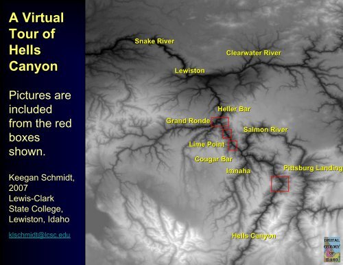
A Virtual<br />
Tour <strong>of</strong><br />
<strong>Hells</strong><br />
<strong>Canyon</strong><br />
Snake River<br />
Lewiston<br />
Clearwater River<br />
Pictures are<br />
included<br />
from the red<br />
boxes<br />
shown.<br />
Keegan Schmidt,<br />
2007<br />
Lewis-Clark<br />
State College,<br />
Lewiston, Idaho<br />
klschmidt@lcsc.edu<br />
Grand Ronde<br />
Lime Point<br />
Cougar Bar<br />
Heller Bar<br />
Imnaha<br />
Salmon River<br />
<strong>Hells</strong> <strong>Canyon</strong><br />
Pittsburg Landing
Lime Point<br />
Grand Ronde<br />
Heller Bar<br />
Northern entrance to Hell’s <strong>Canyon</strong> looking south up the Snake River, at the mouth <strong>of</strong><br />
the Grand Ronde River, which drains northeast from the Blue and Wallowa Mountains in<br />
Oregon.
CRB<br />
CRB<br />
Ws<br />
Mb<br />
Dc<br />
Limekiln Fault<br />
Grand Ronde<br />
CRB<br />
Heller Bar<br />
Same view as last slide. Limekiln fault brings basement rocks to south up against Columbia<br />
River Basalt to north. Note: Columbia River Basalt lying unconformably on basement south<br />
<strong>of</strong> the fault. From limekiln fault south, the section is dipping northwest, thus, as you go up<br />
the river you are going down section, starting with the Martin Bridge Limestone (MB),<br />
Doyle Creek (DC) and Ws (Wild Sheep Creek Formations).
View to the west looking up the Grande Ronde, and across the Snake, flowing north to the<br />
right. Heller Bar is around the corner on the right. Rogersburg, WA is the settlement on the<br />
east side <strong>of</strong> the river. Limekiln fault runs right <strong>of</strong> north dipping Martin Bridge limestone, and<br />
Doyle Creek volcaniclastic rocks are beneath Martin Bridge on the far left.
View to east <strong>of</strong> Snake River flowing north across Limekiln fault at north end <strong>of</strong> <strong>Hells</strong><br />
<strong>Canyon</strong>. Lime Point is landmark in foreground, (in Washington).<br />
Lime point<br />
Limekiln<br />
Fault
H = Hurwall above the Martin Bridge. Lime Point is held up an intrusion <strong>of</strong> quartz diorite<br />
<strong>of</strong> Jurassic or Cretaceous age.<br />
H<br />
CRB<br />
CRB<br />
Mb<br />
Dc<br />
Ws<br />
Lime point<br />
Limekiln<br />
Fault
Stratigraphy <strong>of</strong> the Wallowa Terrane, from Vallier, 1998<br />
Folding, faulting, & uplift<br />
Mid-Late Jurassic<br />
shale & conglomerate<br />
Uplift & erosion<br />
Late Triassic- Early<br />
Jurassic limestone<br />
Arc volcanism ceases<br />
Permian-Triassic<br />
island arc volcanism<br />
(active subduction)
Contact <strong>of</strong> Doyle Creek under Martin Bridge, on the east side <strong>of</strong> the river from Lime Point.
Martin Bridge limestone at Lime Point area.
Cleaved Doyle Creek formation<br />
<strong>of</strong> andesitic volcaniclastic rocks<br />
eroded from Permian islands.<br />
Note prominent cleavage<br />
development.
View to the southeast <strong>of</strong> Cave Gulch coming into Snake River from the east. On the right<br />
are large landslide complexes underlain by Coon Hollow Formation (Jurassic).<br />
Cave Gulch<br />
Cache Cr
Landslide complex looking south across Cave Gulch. Landslide complex on the right.
Cougar<br />
Bar<br />
Cottonwood Cr<br />
View to the north (Idaho is on the right). Cottonwood Creek drains Craig Mountain<br />
south <strong>of</strong> Lewiston.
Ch<br />
Cougar<br />
Bar<br />
Ch<br />
CRB<br />
Ws<br />
Ws<br />
CRB<br />
Cottonwood Cr<br />
Ws<br />
Ws<br />
CRB<br />
Ch = Coon Hollow Formation above the Wild Sheep Creek Formation. Martin Bridge<br />
and Doyle Creek and Hurwall formations are not present across the unconformity.
Wallowa Terrane Stratigraphy<br />
Folding, faulting, & uplift<br />
Mid-Late Jurassic<br />
shale & conglomerate<br />
Uplift & erosion<br />
Late Triassic- Early<br />
Jurassic limestone<br />
Arc volcanism ceases<br />
Permian-Triassic<br />
island arc volcanism<br />
(active subduction)<br />
From Vallier, 1998
Ch<br />
unconformity<br />
Ws<br />
View to south, upstream from Cougar Bar <strong>of</strong> shallowly north dippking unconformity.<br />
Note the difference in dip <strong>of</strong> Wild Sheep vs. Coon Hollow.
View looking west, coming down Kurry Creek from Whitebird, road to Pittsburg Landing.<br />
Kurry<br />
Creek<br />
Upper<br />
Pittsburg<br />
Lower<br />
Pittsburg
In Oregon, Columbia River Basalt’s lie unconformably on Wallowa terrane basement. In<br />
basement, Cougar Creek intrusive complex is thrust over rest <strong>of</strong> volcano-sedimentary<br />
section. The rest <strong>of</strong> the section is south plunging anitcline in Wild Sheep, Doyle Creek, and<br />
Coon Hollow formations. Much <strong>of</strong> the Quaternary deposits are Bonneville flood deposits.<br />
CRB<br />
Klopton Cr<br />
Thrust fault<br />
Cougar Cr<br />
Intrusive<br />
complex<br />
Ch<br />
Dc<br />
Upper<br />
Pittsburg<br />
Q<br />
Lower<br />
Pittsburg<br />
Ws<br />
CRB<br />
Kurry<br />
Cr<br />
Ch<br />
CRB
View looking west down Kurry Creek to Columbia River Basalt in Oregon. Complex<br />
structure in foreground near Pittsburg Landing.
View north looking downstream in Snake River at the north end <strong>of</strong> Pittsburg Landing. Wild<br />
Sheep Creek volcanics are promenent outcrops. Subdued outcrops in foreground are<br />
Doyle Creek Formation.
View same place. Looking east into thick conglomerates <strong>of</strong> Coon Hollow Formation above.<br />
Doyle Creek Formation below.
Conglomerates <strong>of</strong> the Coon Hollow Formation, Klopton Creek thrust faults is in middle<br />
distance, placing Courgar Creek complex on shales <strong>of</strong> marine Coon Hollow. Splay in front<br />
places the marine black shale <strong>of</strong> the Coon Hollow on the conglomerates.
Same outcrop. Fossil Wood in Coon Hollow Formation. Fluvial channel conglomerates.<br />
Dorsey and LeMaskin (in prep).
Ammonite in marine Coon Hollow Formation.
Megaripples in Bonneville Gravels near upper Pittsburg Landing. View is to the east.<br />
Klopton Creek drains west from Idaho.
Upper<br />
Pittsburg<br />
Kurry Cr<br />
Lower<br />
Pittsburg<br />
Same area, view is to the south.
Ch<br />
Kurry Cr<br />
Upper<br />
Pittsburg<br />
Q<br />
Lower<br />
Pittsburg<br />
Cougar Cr<br />
Intrusive<br />
complex<br />
Klopton Cr thrust fault<br />
Ch<br />
Dc<br />
CRB<br />
Ws<br />
Annotated view showing geology over topography.
Same view, except from the ground. View is to the south from the ground. Kurry<br />
Creek is in foreground. High topography is the Cougar Creek Complex.
Cougar Creek instrusive complex. Mylonitic along Klopton Creek Thrust. On right is<br />
mylonitic granites and diorites, quartz diorites, andesites, tyrondhemites.