K-96 Location Study - Kansas Department of Transportation
K-96 Location Study - Kansas Department of Transportation
K-96 Location Study - Kansas Department of Transportation

Create successful ePaper yourself
Turn your PDF publications into a flip-book with our unique Google optimized e-Paper software.
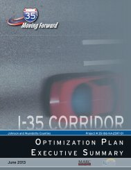
K-<strong>96</strong> <strong>Location</strong> <strong>Study</strong><br />
From Southeast <strong>of</strong> Nickerson to North <strong>of</strong> Sterling, <strong>Kansas</strong><br />
Project No. <strong>96</strong>-106-KA-1007-01<br />
Rice and Reno Counties<br />
December 2010<br />
Prepared for:<br />
By:
K-<strong>96</strong> <strong>Location</strong> <strong>Study</strong><br />
K-<strong>96</strong> <strong>Location</strong> <strong>Study</strong><br />
From Southeast <strong>of</strong> Nickerson to North <strong>of</strong> Sterling, <strong>Kansas</strong><br />
Project No. <strong>96</strong>-106 KA-1007-01<br />
Rice and Reno Counties<br />
WILSON & COMPANY, INC., ENGINEERS & ARCHITECTS<br />
in association with<br />
HNTB CORPORATION and<br />
PEC (PROFESSIONAL ENGINEERING CONSULTANTS, PA)<br />
December 2010
THIS PAGE INTENTIONALLY LEFT BLANK<br />
K-<strong>96</strong> <strong>Location</strong> <strong>Study</strong>
K-<strong>96</strong> <strong>Location</strong> <strong>Study</strong><br />
TABLE OF CONTENTS<br />
1.0 EXECUTIVE SUMMARY<br />
1.1 Introduction ............................................................................. 1-1<br />
1.2 <strong>Study</strong> Limits and Goals ........................................................... 1-1<br />
1.3 Existing K-<strong>96</strong> .......................................................................... 1-2<br />
1.4 Purpose and Need .................................................................. 1-2<br />
1.5 Corridor Concepts .................................................................. 1-3<br />
1.6 Recommended Corridor and Highway Type ........................... 1-3<br />
1.7 Summary <strong>of</strong> Public Involvement ............................................. 1-5<br />
1.8 Estimated Project Costs ......................................................... 1-5<br />
2.0 PROJECT DESCRIPTION<br />
2.1 Background ............................................................................ 2-1<br />
2.2 Project Initiatives .................................................................... 2-2<br />
2.3 <strong>Study</strong> Limits and Goals ........................................................... 2-2<br />
3.0 PROJECT PURPOSE AND NEED<br />
3.1 General <strong>Study</strong> Limits and Goals ............................................... 3-1<br />
3.2 Accident Experience ................................................................. 3-1<br />
3.3 Existing Traffic .......................................................................... 3-1<br />
3.4 Roadway Geometrics ................................................................ 3-1<br />
3.5 Accommodation <strong>of</strong> Future Growth ............................................ 3-1<br />
3.6 Economic Vitality ....................................................................... 3-2<br />
3.7 Project Purpose ........................................................................ 3-2<br />
3.8 Project Need ............................................................................. 3-2<br />
3.9 Conclusion ................................................................................ 3-2<br />
4.0 CONCEPT DEVELOPMENT AND EVALUATION<br />
4.1 Type <strong>of</strong> Highways Considered ................................................ 4-1<br />
4.2 Design Criteria ........................................................................ 4-1<br />
4.3 Initial Corridor Development ................................................... 4-2<br />
4.4 Initial Corridor Screening ........................................................ 4-3<br />
4.5 Second-Level Corridor Screening........................................... 4-4<br />
4.6 Third–Level Screening <strong>of</strong> Alternates....................................... 4-6<br />
4.7 Final Screening and Development <strong>of</strong><br />
Recommended Corridor ......................................................... 4-8<br />
5.0 SOCIAL, ECONOMIC & ENVIRONMENTAL<br />
FACTORS<br />
5.1 Introduction ............................................................................. 5-1<br />
5.2 Land Use ................................................................................ 5-1<br />
5.3 Socioeconomic Issues ............................................................ 5-1<br />
5.4 Right-<strong>of</strong>-Way Needs ............................................................... 5-2<br />
5.5 Bicycles and Pedestrian Use .................................................. 5-2<br />
5.6 Air Quality ............................................................................... 5-2<br />
5.7 Noise Impacts ......................................................................... 5-2<br />
5.8 Biological Resources .............................................................. 5-2<br />
5.9 Cultural Resources ................................................................. 5-3<br />
5.10 Hazardous Materials ............................................................... 5-4<br />
6.0 RECOMMENDED ALTERNATIVE<br />
6.1 Corridor <strong>Location</strong> and Description .......................................... 6-1<br />
6.2 Highway Type ......................................................................... 6-2<br />
7.0 PUBLIC INVOLVEMENT AND AGENCY<br />
COORDINATION<br />
7.1 Introduction ............................................................................. 7-1<br />
7.2 Contact Information ................................................................ 7-1<br />
7.3 Mailing List .............................................................................. 7-1<br />
7.4 Community Interviews ............................................................ 7-1<br />
7.5 Community Advisory Group .................................................... 7-1<br />
7.6 Public Meetings ...................................................................... 7-1<br />
7.7 Comment Database ................................................................ 7-2<br />
7.8 Media Outreach ...................................................................... 7-2<br />
7.9 Project Website ...................................................................... 7-2<br />
APPENDIX A – TRAFFIC DATA<br />
A.1 Past and Current Traffic Volumes ......................................... A-1<br />
A.2 Corridor Access and Changes in Local Traffic Circulation .... A-1<br />
A.3 Future Traffic Volumes .......................................................... A-2<br />
A.4 Accident History ..................................................................... A-3
K-<strong>96</strong> <strong>Location</strong> <strong>Study</strong><br />
LIST OF FIGURES<br />
1-1. K-<strong>96</strong>, a rural 2-lane highway<br />
in south central <strong>Kansas</strong> .......................................................... 1-1<br />
1-2 Map <strong>of</strong> K-<strong>96</strong> <strong>Study</strong> Area ......................................................... 1-1<br />
1-3 Roads, Railroads, Rivers and Creeks<br />
In the K-<strong>96</strong> <strong>Study</strong> Area ........................................................... 1-2<br />
1-4 View southbound on K-<strong>96</strong> from downtown Sterling<br />
to the K&O Railroad crossing ................................................. 1-2<br />
1-5 K-<strong>96</strong> Alternates Development and Screening Process ........... 1-3<br />
1-6 Recommended Corridor <strong>Location</strong> and Key Features ............. 1-4<br />
2-1 Select <strong>Kansas</strong> Highways ........................................................ 2-1<br />
2-2 K-<strong>96</strong> north <strong>of</strong> Sterling .............................................................. 2-1<br />
2-3 K-<strong>96</strong> between Sterling and Nickerson .................................... 2-1<br />
2-4 K-<strong>96</strong> southeast <strong>of</strong> Nickerson .................................................. 2-1<br />
2-5 <strong>Study</strong> Area for K-<strong>96</strong> <strong>Location</strong> <strong>Study</strong> ....................................... 2-2<br />
3-1 FY 2009 Traffic Volumes on K-<strong>96</strong> and Connecting<br />
Major Collectors ...................................................................... 3-1<br />
4-1 Map <strong>of</strong> Initial Corridor Alternates ............................................ 4-2<br />
4-2 Alternates Considered in Third-Level Screening ................... 4-6<br />
4-3. Final Two Alternates Considered............................................ 4-8<br />
4-4 K-<strong>96</strong> Alternates Development and Screening Process ........... 4-9<br />
5-1 Satellite View <strong>of</strong> <strong>Study</strong> Area ................................................... 5-1<br />
6-1 Recommended Corridor <strong>Location</strong> and Key Features ............. 6-1<br />
6-2 Typical Section ....................................................................... 6-2<br />
6-3 Recommended Corridor <strong>Location</strong> in the Vicinity<br />
Of Sterling ............................................................................... 6-3<br />
6-4 Recommended Corridor <strong>Location</strong> East <strong>of</strong> Sterling ................. 6-4<br />
6-5 Recommended Corridor <strong>Location</strong> in the Vicinity<br />
<strong>of</strong> the Rice/Reno County Line ................................................. 6-5<br />
6-6 Recommended Corridor <strong>Location</strong> North and<br />
East <strong>of</strong> Nickerson ................................................................... 6-6<br />
6-7 Recommended Corridor <strong>Location</strong> Southeast <strong>of</strong> Nickerson ..... 6-7<br />
6-8 Recommended Corridor <strong>Location</strong> in the Vicinity<br />
<strong>of</strong> Yaggy Road ........................................................................ 6-8<br />
6-9 Recommended Corridor <strong>Location</strong> in the Vicinity <strong>of</strong> the<br />
Sterling Interchange ............................................................... 6-9<br />
6-10 Recommended Corridor <strong>Location</strong> in the Vicinity <strong>of</strong> the<br />
Nickerson Interchange .......................................................... 6-10<br />
6-11 Recommended Corridor <strong>Location</strong> in the Vicinity<br />
<strong>of</strong> the 56 th Avenue Interchange ............................................ 6-10<br />
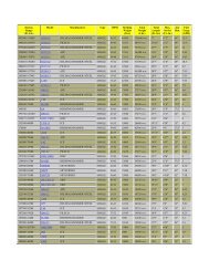
A-1 FY 2009 Daily Traffic on K-<strong>96</strong>, K-14 and<br />
Nearby Collector Roads ........................................................ A-1<br />
A-2 FY 2009 Heavy Commercial Truck Volumes on K-<strong>96</strong> ........... A-1<br />
A-3 Projected 2015 Traffic on K-<strong>96</strong> as an Improved Facility ........ A-2<br />
A-4 Projected 2035 Traffic on K-<strong>96</strong> as an Improved Facility ....... A-3<br />
LIST OF TABLES<br />
1-1 Project Cost Summary ............................................................ 1-5<br />
1-2 Project Cost Summary – 2-Lane on 4-Lane Right-<strong>of</strong>-Way ..... 1-5<br />
4-1 Design Criteria for K-<strong>96</strong> Roadway Alternates ......................... 4-1<br />
4-2 Design Criteria for Local Road System .................................. 4-2<br />
4-3 Comparison <strong>of</strong> Preliminary Alternates for<br />
Initial Screening ...................................................................... 4-4<br />
4-4 Comparison <strong>of</strong> Preliminary Alternates<br />
for Second-Level Screening ................................................... 4-5<br />
4-5 Comparison <strong>of</strong> Combined Alternates ...................................... 4-7<br />
4-6 Comparison <strong>of</strong> the Final Two Alternates ................................ 4-8<br />
5-1 State-Listed Species with Designated Critical Habitat<br />
In Reno and Rice Counties, and Relevance to K-<strong>96</strong> .............. 5-3<br />
7-1 CAG Meeting Schedule .......................................................... 7-1<br />
A-1 K-<strong>96</strong> Accident Summary, 2005 to 2009 ................................. A-3
K-<strong>96</strong> <strong>Location</strong> <strong>Study</strong><br />
1.0 Executive Summary<br />
Figure 1-2. Map <strong>of</strong> K-<strong>96</strong> <strong>Study</strong> Area<br />
1.1 Introduction<br />
During meetings to update the Statewide Long Range <strong>Transportation</strong> Plan, participants identified the<br />
need for a four-lane highway between the <strong>Kansas</strong> cities <strong>of</strong> Nickerson and Sterling. In 2008, the<br />
<strong>Kansas</strong> <strong>Department</strong> <strong>of</strong> <strong>Transportation</strong> (KDOT) selected Wilson & Company, Inc., Engineers &<br />
Architects <strong>of</strong> Salina, <strong>Kansas</strong>, to conduct an engineering location study for this concept.<br />
An existing two-lane highway, K-<strong>96</strong>, connects Sterling and Nickerson to each other and also to the<br />
larger cities <strong>of</strong> Hutchison and Wichita to the southeast, as well as to Lyons and points west. The<br />
segment <strong>of</strong> K-<strong>96</strong> connecting Sterling (2000 Census population 2,642) and Nickerson (population<br />
1,194) is a paved, rural highway that does not meet modern design standards (see Figure 1-1). It<br />
follows a north/south alignment through Sterling and an east/west alignment into Nickerson for a<br />
total trip length <strong>of</strong> about 10.5 miles. By comparison, a straighter diagonal route connecting the<br />
cities would have the potential to cut up to three miles <strong>of</strong>f <strong>of</strong> the existing K-<strong>96</strong> distance.<br />
Figure 1-1. K-<strong>96</strong>, a rural 2-lane highway in south central <strong>Kansas</strong><br />
1.2 <strong>Study</strong> Limits and Goals<br />
The area encompassed by this location study begins southeast <strong>of</strong> Nickerson at Yaggy Road and<br />
existing K-<strong>96</strong>, and extends for 15 miles to the northwest, connecting with existing K-<strong>96</strong>/K-14 north<br />
<strong>of</strong> Sterling. The study examined a six-mile wide area, roughly centered on the existing highway<br />
and its hypothetical alignment if it continued to the northwest from Nickerson. The study area is<br />
shown in Figure 1-2.<br />
The goal <strong>of</strong> the study was to determine the location <strong>of</strong> a new highway corridor and determine the<br />
type <strong>of</strong> improvements needed to meet the long-term needs the highway must serve. The study<br />
examined feasible locations for a four-lane highway, including the possible upgrade <strong>of</strong> the existing<br />
two-lane to a four-lane on its current alignment. The study process utilized data from past studies<br />
and evaluated new data from a variety <strong>of</strong> sources.<br />
1-1
K-<strong>96</strong> <strong>Location</strong> <strong>Study</strong><br />
1.3 Existing K-<strong>96</strong><br />
State Highway K-<strong>96</strong> in south central <strong>Kansas</strong> is generally an east to west route, but through the<br />
study area connecting Nickerson and Sterling it includes segments running north/south, east/west<br />
and diagonally, as seen in Figure 1-3. It is part <strong>of</strong> the state highway system and is classified as a<br />
principal arterial by the <strong>Kansas</strong> <strong>Department</strong> <strong>of</strong> <strong>Transportation</strong>. Southeast <strong>of</strong> Nickerson, K-<strong>96</strong><br />
parallels the <strong>Kansas</strong> & Oklahoma (K&O) Railroad. The railroad continues northwest to Sterling<br />
(and beyond), but K-<strong>96</strong> turns westward to a junction with State Highway 14, and continues<br />
northward to Sterling as both K-<strong>96</strong> and K-14.<br />
Figure 1-3. Roads, Railroads, Rivers and Creeks in the K-<strong>96</strong> <strong>Study</strong> Area<br />
highway other than resurfacing projects to maintain the condition <strong>of</strong> the pavement, plus the<br />
replacement <strong>of</strong> the two K-<strong>96</strong> bridges over the Arkansas River.<br />
Since the 1990’s, the communities <strong>of</strong> Sterling and Nickerson have held discussions with KDOT<br />
about the prospect <strong>of</strong> building a four-lane highway between the two cities. During mid-2008, as<br />
part <strong>of</strong> this location study, approximately two dozen community leaders were contacted and asked<br />
to be interviewed about the K-<strong>96</strong> <strong>Location</strong>s <strong>Study</strong> project. Potential interviewees were suggested<br />
by community leaders <strong>of</strong> Reno and Rice counties, KDOT, and those involved in previous K-<strong>96</strong><br />
corridor meetings. The interviewees included not only residents <strong>of</strong> Nickerson and Sterling, but<br />
also some from other parts <strong>of</strong> the greater K-<strong>96</strong> corridor, including the cities <strong>of</strong> Hutchinson and<br />
Great Bend. As the result <strong>of</strong> this effort, 18 interviews were conducted. Each interviewee was<br />
asked the same set <strong>of</strong> questions and provided feedback on underlying issues and ways to provide<br />
effective communication within the surrounding communities.<br />
The section <strong>of</strong> K-<strong>96</strong> between Nickerson and Sterling was constructed in the late 1950’s and early<br />
1<strong>96</strong>0’s. Sight distance is not a problem on this highway, which is relatively straight and flat, but<br />
the existing road is narrow and lacks shoulders in some areas. This route does not meet current<br />
design criteria for elements such as roadway width, ditch side slopes and curve geometrics.<br />
Since its initial construction, there have been no major upgrades or improvements made to the<br />
1-2<br />
The purpose <strong>of</strong> the community interviews was to gather information from technical experts,<br />
elected <strong>of</strong>ficials, and civic leaders to educate the study team <strong>of</strong> local issues and concerns to<br />
consider when determining the project corridor, and to help identify possible members for a project<br />
Community Advisory Group. For the most part, those interviewed were aware <strong>of</strong> the project and<br />
stressed the need for a new roadway serving the two communities. Input from these interviews<br />
and from the Community Advisory Group (CAG) was used to develop the project’s purpose and<br />
need. In addition to the CAG, a Technical Advisory Group (TAC) was formed to assist the study<br />
team with technical data gathering.<br />
1.4 Purpose and Need<br />
The purpose <strong>of</strong> the project is to create a safe and more efficient corridor with enhanced regional<br />
mobility that will also maintain or improve opportunities for economic vitality in the linked<br />
communities and the surrounding area.<br />
The need for a more efficient corridor arises from the fact that the existing route is circuitous and<br />
does not provide predictable travel times due to the locales through which it passes. The route<br />
passes through the communities <strong>of</strong> Nickerson and Sterling, taking 400 to 500 heavy trucks each<br />
day through downtown<br />
districts and past schools and<br />
residential areas. In Sterling,<br />
K-<strong>96</strong> passes north/south<br />
through the entire town,<br />
including the downtown area,<br />
and skirts the campus <strong>of</strong><br />
Sterling College at the north<br />
end <strong>of</strong> town. In addition, the<br />
existing route crosses the K &<br />
O Railroad tracks at-grade in<br />
both communities and thus is<br />
subject to motorist delays<br />
when trains pass through<br />
each city. Figure 1-4 shows<br />
the crossing in Sterling.<br />
Figure 1-4.<br />
View southbound on K-<strong>96</strong> from downtown Sterling
K-<strong>96</strong> <strong>Location</strong> <strong>Study</strong><br />
Further travel unpredictability on K-<strong>96</strong> results from occasional flooding, as the existing route<br />
crosses the Arkansas River twice (see Figure 1-3), as well as other drainages, and much <strong>of</strong> the<br />
route is located within the 100-year floodplain. Additionally, the particular location and design <strong>of</strong><br />
the route makes it notably prone to major snow drifts in winter at the curve where the road<br />
changes from its orientation <strong>of</strong> east-west to north-south.<br />
Figure 1-5. K-<strong>96</strong> Alternates Development and Screening Process<br />
From the community interviews it was learned that these problems cause local travelers to avoid<br />
use <strong>of</strong> K-<strong>96</strong> and to instead use other local roads for their trip. Thus, the inefficiencies <strong>of</strong> the<br />
existing K-<strong>96</strong> route impose an increased maintenance burden on local governments in the area.<br />
An improved corridor is needed not only to link the two cities more efficiently, but also to link them<br />
to the surrounding region. Previous studies have established a vision for K-<strong>96</strong> to become an<br />
improved corridor linking Wichita and I-70. Whether or not that vision is ultimately realized,<br />
improvements to the corridor in the Nickerson to Sterling area would have independent utility by<br />
addressing inefficiencies that hamper both local and regional mobility in this area.<br />
As noted above, local input helped the study team identify priority needs that we used to select a<br />
preferred corridor for proposed improvements. Those needs are as follows:<br />
<br />
<br />
<br />
<br />
<br />
<br />
Provide safe and efficient regional travel and mobility<br />
Accommodate local and regional growth<br />
Accommodate oversized freight on non-local roadways<br />
Reduce regional and freight traffic flows/demands on locally owned and maintained<br />
roadways<br />
Provide predictable travel times for facility users, including emergency response vehicles<br />
Improve the highway’s level <strong>of</strong> access control<br />
These needs are discussed further in Chapter 3 <strong>of</strong> this report.<br />
1.5 Corridor Concepts<br />
In the concept development process, improvements to the existing K-<strong>96</strong> route were determined to<br />
not meet the project purpose and need, which necessitated the identification <strong>of</strong> potential new<br />
corridor locations. Initially, six corridor routes were identified for consideration. Each route was<br />
split into two segments: Segment A, the northwestern half <strong>of</strong> the route including Sterling; and<br />
Segment B, the southeastern half <strong>of</strong> the route including Nickerson. Most <strong>of</strong> the alternates had a<br />
common junction in the middle, allowing various combinations <strong>of</strong> A-segment alternates with<br />
B-segment alternates. All alternates provided bypasses for both communities, developed to avoid<br />
substantial impacts to businesses and residents located adjacent to the existing highway.<br />
Corridor concepts considered can be found in Chapter 4.<br />
Early in the screening process, alternates were considered separately for segments A and B, in a<br />
mix-and-match approach. Once seven <strong>of</strong> the initial 11 segments had been screened out, the<br />
remaining segments were combined into specific combinations (e.g., A-4 with B-5). Later in the<br />
process, three additional alternates (AB-7, AB-8 and AB-9) were developed for consideration.<br />
Four <strong>of</strong> the combinations were screened out, leaving a final combination as the preferred<br />
alternate. A diagram outlining the process is provided in Figure 1-5.<br />
1.6 Recommended Corridor and Highway Type<br />
Through a series <strong>of</strong> refinements and evaluations, a recommended corridor was developed by the<br />
study team. Public input from the Community Advisory Group and citizens helped to determine<br />
the 1,000 ft. corridor within which the proposed highway will be located. A general description <strong>of</strong><br />
the recommended corridor location is shown below, following the corridor from southeast<br />
(Nickerson vicinity) to northwest (Sterling vicinity):<br />
<br />
<br />
<br />
<br />
<br />
The new route would diverge northward from existing K-<strong>96</strong> at Yaggy Road.<br />
A grade-separated interchange at 56 th Avenue (RS 2026) would serve the Yaggy Road and<br />
Willowbrook areas and also provide a convenient route (RS 2026) to highway K-61<br />
northeast <strong>of</strong> Hutchinson.<br />
A sideroad overpass (no access) would carry 82 nd Avenue (an east-west road) over the<br />
highway between Dean Road and Herren Road.<br />
North <strong>of</strong> 82 nd Avenue, the new route turns west.<br />
A grade-separated interchange with the north-south Nickerson Road (RS 560) would<br />
provide access for the city <strong>of</strong> Nickerson between 95 th Avenue and 108 th Avenue (Note:<br />
Existing K-<strong>96</strong> would remain in place, usable as a local road from Nickerson Road to 56 th<br />
Avenue).<br />
1-3
K-<strong>96</strong> <strong>Location</strong> <strong>Study</strong><br />
The route proceeds northwest, crossing over Avenue X with a sideroad underpass (20 th<br />
Road would become discontinuous, requiring a short jog onto Avenue X in order to<br />
continue north/south).<br />
The route proceeds northwest and a sideroad overpass would carry Avenue V over K-<strong>96</strong><br />
between 18 th Road and 19 th Road.<br />
The route proceeds westward and a sideroad overpass would carry 17 th Road over K-<strong>96</strong><br />
between Avenue V and Avenue U.<br />
At the K&O Railroad, a mainline overpass would carry K-<strong>96</strong> over the railroad tracks.<br />
The route proceeds westward to a grade-separated interchange slightly north and east <strong>of</strong><br />
Sterling, just south <strong>of</strong> Avenue U, between existing K-<strong>96</strong> and 16 th Road.<br />
The route continues north to tie into existing K-<strong>96</strong> just south <strong>of</strong> Avenue T.<br />
In the vicinity <strong>of</strong> the new Sterling interchange (two details above), a new local road would<br />
connect existing K-<strong>96</strong> and 16 th Road.<br />
Avenue U would become discontinuous, tying into the new connector road on each side <strong>of</strong><br />
the Sterling interchange.<br />
Figure 1-6 presents the location <strong>of</strong> the recommended corridor, interchanges, overpasses and<br />
underpass.<br />
Figure 1-6. Recommended Corridor <strong>Location</strong> and Key Features<br />
The recommended highway type is a four-lane divided highway with access provided only at<br />
grade-separated interchanges, consistent with a freeway design.<br />
Access Points<br />
It was noted above that the existing K-<strong>96</strong> would remain in place, open for use as a locally<br />
maintained road. Constructing the new K-<strong>96</strong> facility will add a new, safe and faster route for trips<br />
between Nickerson and Sterling and other cities beyond. The route description above indicated<br />
there would be three grade-separated interchanges providing access for motorists to enter or exit<br />
the new highway. These are:<br />
<br />
<br />
<br />
In Reno County, at 56 th Avenue (RS 2026) serving the Yaggy Road and Willowbrook areas<br />
In Reno County, immediately north <strong>of</strong> Nickerson<br />
In Rice County, northeast <strong>of</strong> Sterling, west <strong>of</strong> the intersection <strong>of</strong> 16 th Road and Avenue U<br />
Overpass and Underpass <strong>Location</strong>s<br />
Opportunities to cross, but not enter or exit the highway would be located as follows:<br />
In Reno County, about two miles east <strong>of</strong> Nickerson, 82 nd Avenue (RS 673) would cross over<br />
the new K-<strong>96</strong> highway<br />
In Rice County, between Nickerson and Sterling, the new K-<strong>96</strong> would cross over Avenue X, a<br />
local east-west road<br />
In Rice County, about 2.5 miles east <strong>of</strong> Sterling, Avenue V (RS 572) would cross over the new<br />
K-<strong>96</strong> highway<br />
In Rice County, about 1.5 miles northeast <strong>of</strong> Sterling, 17 th Road would cross over the new K-<strong>96</strong><br />
highway<br />
The interchanges and overpass/underpass locations recommended for the project are the only<br />
places where local traffic could cross the new highway. These locations are at reasonable<br />
intervals to minimize disruption to local traffic and also to provide connection to key routes in the<br />
area. There are a total <strong>of</strong> seven crossing locations available over the length <strong>of</strong> the new highway<br />
corridor.<br />
1-4
K-<strong>96</strong> <strong>Location</strong> <strong>Study</strong><br />
1.7 Summary <strong>of</strong> Public Involvement<br />
Public comment and participation played a key role in determining the recommended corridor and<br />
highway type. The public’s input was solicited in a number <strong>of</strong> ways including:<br />
<br />
<br />
<br />
<br />
<br />
<br />
Interviews with community leaders (18 conducted)<br />
Community Advisory Group (5 meetings)<br />
Technical Advisory Committee<br />
Project website<br />
Media releases<br />
Public information meetings (2 held)<br />
A detailed summary <strong>of</strong> public involvement activities can be found in Chapter 7.<br />
1.8 Estimated Project Costs<br />
The total estimated cost <strong>of</strong> the project is shown in Table 1-1, broken into two individual project<br />
segments, corresponding to the portions within each county. Upon determination <strong>of</strong> a preferred<br />
alternative, the estimated project costs were further defined to establish budget level cost<br />
estimates for project programming purposes.<br />
County<br />
Table 1-2. Project Cost Summary – 2-Lane on 4-Lane Right <strong>of</strong> Way<br />
($ millions)<br />
Preliminary<br />
Engineering<br />
Construction<br />
Engineering<br />
Right-<strong>of</strong>-<br />
Way<br />
Utility<br />
Adjustments<br />
Construction<br />
Total<br />
Costs<br />
Reno $2.424 $3.422 $3.590 $3.517 $28.518 $41.471<br />
Rice $2.728 $3.851 $3.135 $2.655 $32.093 $44.462<br />
Totals $5.152 $7.273 $6.725 $6.172 $60.611 $85.933<br />
Note: All costs are expressed in fiscal year (FY) 2010 dollars.<br />
The cost estimates discussed above are not separately detailed in a later chapter <strong>of</strong> this report,<br />
but are available as internal KDOT administrative documentation if needed.<br />
Construction costs include necessary work to build the four-lane freeway. Also included are the<br />
estimated costs for rehabilitation work on the portions <strong>of</strong> existing K-<strong>96</strong> that will be relinquished to<br />
the respective counties.<br />
County<br />
Table 1-1. Project Cost Summary – Four-Lane Access Controlled Freeway<br />
($ millions)<br />
Preliminary<br />
Engineering<br />
Construction<br />
Engineering<br />
Right-<strong>of</strong>-<br />
Way<br />
Utility<br />
Adjustments<br />
Construction<br />
Total<br />
Costs<br />
Reno $3.514 $4.<strong>96</strong>1 $3.590 $3.517 $41.338 $56.920<br />
Rice $4.069 $5.745 $3.135 $2.655 $47.871 $63.475<br />
Totals $7.583 $10.706 $6.725 $6.172 $89.209 $120.395<br />
Note: All costs are expressed in fiscal year (FY) 2010 dollars.<br />
Depending on future conditions including growth, traffic demand and funding availability, there is<br />
potential for the project to be constructed in an interim condition that would operate two traffic<br />
lanes (one in each direction) within a corridor for which design and right-<strong>of</strong>-way provide for future<br />
completion <strong>of</strong> four traffic lanes (two in each direction). Because there are many cost elements<br />
(design, right-<strong>of</strong>-way, utility adjustments and some bridges) which must be completed for the<br />
ultimate project in order to accommodate the interim condition, the costs <strong>of</strong> the “two on four”<br />
interim condition typically comprise much more than half <strong>of</strong> the ultimate project total. Estimated<br />
costs for the phased construction approach are shown in Table 1.2.<br />
1-5
K-<strong>96</strong> <strong>Location</strong> <strong>Study</strong><br />
2.0 Project Description<br />
Figure 2-2. K-<strong>96</strong> north <strong>of</strong> Sterling (view to the south)<br />
2.1 Background<br />
K-<strong>96</strong> Highway is a west to east roadway connecting Sterling to Nickerson in south central <strong>Kansas</strong>,<br />
as shown in Figure 2-1. It is part <strong>of</strong> the state highway system and is classified as a principal<br />
arterial by the <strong>Kansas</strong> <strong>Department</strong> <strong>of</strong> <strong>Transportation</strong>.<br />
Figure 2-1. Select <strong>Kansas</strong> Highways<br />
The portion <strong>of</strong> K-<strong>96</strong><br />
within the study area<br />
contains both rural and<br />
urban roadways, eastwest<br />
and north-south<br />
segments, and a<br />
northwest to southeast<br />
diagonal section that<br />
parallels the <strong>Kansas</strong> &<br />
Oklahoma Railroad. In<br />
the rural areas, there<br />
are intersections at<br />
junctions with county<br />
and local roadways, and<br />
dozens <strong>of</strong> private<br />
entrances that directly<br />
access the highway. There are two at-grade rail crossings, one in Sterling and the other in<br />
Nickerson.<br />
Figure 2-3. K-<strong>96</strong> between Sterling and Nickerson (view to the east)<br />
The existing roadway was constructed in the late 1950’s and early 1<strong>96</strong>0’s. Outside Nickerson and<br />
Sterling, the existing road is a rural, two-lane highway. Inside the city limits, the existing roadway<br />
includes both curb & gutter and open ditch sections, with on-street parking in some areas. The<br />
current route passes through the business areas <strong>of</strong> both towns. Sterling College and Nickerson<br />
High School are immediately adjacent to the highway in their respective communities.<br />
This route does not meet current design criteria for elements such as roadway width, ditch side<br />
slopes and horizontal curve geometrics. Since its initial construction, there have been no major<br />
upgrades or improvements made to the roadway other than resurfacing projects to maintain the<br />
condition <strong>of</strong> the pavement. Both bridges over the Arkansas River between Sterling and Nickerson<br />
were replaced in the mid 1990’s.<br />
Figure 2-4. K-<strong>96</strong> southeast <strong>of</strong> Nickerson (view to northwest)<br />
North <strong>of</strong> Sterling, the existing roadway is comprised <strong>of</strong> two -12’ driving lanes with 6’ wide<br />
composite shoulders comprised <strong>of</strong> bituminous surfacing and turf. This portion <strong>of</strong> the corridor is<br />
depicted in Figure 2-2.<br />
Between Sterling and Nickerson, the roadway is subject to flooding in low areas and closures in<br />
the winter due to snow drifting. As shown in Figure 2-3, this section <strong>of</strong> K-<strong>96</strong> has narrow to no<br />
shoulders and minimal right-<strong>of</strong>-way.<br />
The most modern section <strong>of</strong> the existing road is located southeast <strong>of</strong> Nickerson, shown in Figure<br />
2-4. Once outside the city limits, the roadway is straight with minimal vertical relief, and relatively<br />
2-1
K-<strong>96</strong> <strong>Location</strong> <strong>Study</strong><br />
wide right-<strong>of</strong>-way. This portion <strong>of</strong> K-<strong>96</strong> is orientated on a northwest to southeast diagonal, and<br />
parallels the northeast side <strong>of</strong> the <strong>Kansas</strong> and Oklahoma Railroad. As such, there are numerous<br />
intersections with county and local roads with severely skewed angles <strong>of</strong> intersection, typically at<br />
40 to 50 degrees.<br />
Figure 2-5. <strong>Study</strong> Area for K-<strong>96</strong> <strong>Location</strong> <strong>Study</strong><br />
2.2 Project Initiatives<br />
Upgrades to the highway have been discussed for over two decades. This portion <strong>of</strong> K-<strong>96</strong> was<br />
included in the 1986 Western <strong>Kansas</strong> Turnpike/Freeway Feasibility <strong>Study</strong> completed by HNTB<br />
that looked at routes from Hays to Wichita. In 1999, the Northwest Passage Corridor <strong>Location</strong><br />
<strong>Study</strong> was completed by HNTB that evaluated potential locations for improvements to K-<strong>96</strong> from<br />
Great Bend to Hutchinson. That study was used to prepare a System Enhancement Program<br />
application that was submitted to KDOT for the same section <strong>of</strong> K-<strong>96</strong> that this present study is<br />
evaluating. The application was for a four-lane, partially access controlled highway. Both<br />
previous studies identified the needs and desires for improved transportation capabilities in the<br />
area.<br />
During development <strong>of</strong> the Long Range <strong>Transportation</strong> Plan (LRTP) conducted by KDOT in 2008<br />
and 2009, locally held public forums generated comments further outlining the public’s desire to<br />
improve K-<strong>96</strong> from Great Bend to Hutchinson.<br />
2.3 <strong>Study</strong> Limits and Goals<br />
The area encompassed by the study begins southeast <strong>of</strong> Nickerson, then continues northwesterly<br />
for approximately 15 miles to north <strong>of</strong> Sterling. The study examined a six-mile wide area roughly<br />
centered on a diagonal line extended through the communities <strong>of</strong> Nickerson and Sterling. This<br />
area is shown in Figure 2-5. K-<strong>96</strong> joins US 56 at Lyons and continues westward to Great Bend.<br />
The study area does not include all <strong>of</strong> existing K-<strong>96</strong> (e.g., west <strong>of</strong> Nickerson and south <strong>of</strong> Sterling)<br />
for reasons that are explained in Chapter 4.<br />
The primary goal <strong>of</strong> the study was to develop the alignment <strong>of</strong> a preferred corridor for<br />
improvements to K-<strong>96</strong>. The location study developed and examined feasible locations for a fourlane<br />
highway. A range <strong>of</strong> alternatives were analyzed including the No Build or “do nothing”<br />
alternate, along with several new corridor alignments. Since all <strong>of</strong> the alternatives except the No<br />
Build option involved new alignments, primary components <strong>of</strong> the alternate evaluations included<br />
identification <strong>of</strong> appropriate bypasses around established communities, and the location <strong>of</strong><br />
appropriate locations for access to the highway.<br />
The goal <strong>of</strong> the study was to develop the most feasible location for the highway. Each alternative<br />
was evaluated on the basis <strong>of</strong> safety, traffic patterns, capacity, social and environmental concerns,<br />
and cost. After receiving input from the general public, affected governmental agencies and the<br />
Community Advisory Group, KDOT selected the final corridor location and the appropriate design<br />
type to serve the traffic needs.<br />
2-2
K-<strong>96</strong> <strong>Location</strong> <strong>Study</strong><br />
3.0 Project Purpose and Need<br />
3.1 General <strong>Study</strong> Limits and Goals<br />
Because K-<strong>96</strong> was built more than half a century ago, it is not surprising that portions <strong>of</strong> the<br />
existing highway do not meet current design criteria for vertical and horizontal alignment. Other<br />
concerns about the existing highway are that it does not provide a direct route between Nickerson<br />
and Sterling, passes through each city, has two at-grade railroad crossings, crosses the Arkansas<br />
River twice and is largely located within the 100-year floodplain. Flooding on K-<strong>96</strong> and snowdrifts<br />
west <strong>of</strong> the K-14 junction occur <strong>of</strong>ten enough to diminish the reliability <strong>of</strong> the existing route,<br />
resulting in use <strong>of</strong> alternate routes during these conditions.<br />
Figure 3-1. FY 2009 Daily Traffic Volumes on K-<strong>96</strong> and Connecting Major Collectors<br />
3.2 Accident Experience<br />
For the five years from 2005 to 2009, there was an average <strong>of</strong> approximately 39 crashes per year<br />
along the stretch <strong>of</strong> K-<strong>96</strong> between 1.4 miles north <strong>of</strong> Nickerson and 4.3 miles southeast <strong>of</strong><br />
Nickerson. On average, there have been about seven injury accidents annually, resulting in about<br />
1.5 persons injured per incident. These statistics encompass a total <strong>of</strong> 197 accidents over the<br />
five-year period, including one human fatality. The most common type <strong>of</strong> accident was collision<br />
with an animal as these totaled 94 (48%) <strong>of</strong> the accidents. Many <strong>of</strong> these collisions involved deer.<br />
Another 21% <strong>of</strong> the accidents were collisions with other vehicles, and 13% were collisions with<br />
fixed objects. Based on these data, the overall weighted accident rate for the highway (per million<br />
miles <strong>of</strong> travel) was 2.08, which is higher than the 1.54 average for similar roadway types<br />
statewide. Future traffic growth (K-<strong>96</strong> volumes are expected to more than double by 2035) will<br />
increase the number <strong>of</strong> travelers exposed to the risks associated with the existing highway<br />
location and design.<br />
3.3 Existing Traffic<br />
Traffic volumes on K-<strong>96</strong> and connecting major collector roads are shown in Figure 3-1. Traffic in<br />
the study area is highest on K-<strong>96</strong> north <strong>of</strong> Sterling and southeast <strong>of</strong> Nickerson, where volumes<br />
range from about 4,560 to 3,850 vehicles per day, respectively. Heavy commercial truck volumes<br />
range from 375 per day north <strong>of</strong> Sterling to 485 trucks per day south <strong>of</strong> Nickerson, and make up<br />
12 to 14 percent <strong>of</strong> the total traffic within the corridor.<br />
The traffic volumes on K-<strong>96</strong> are lower between Nickerson and Sterling than either north or south<br />
<strong>of</strong> these communities. This is a result <strong>of</strong> drivers familiar with the area using county collector roads<br />
RS 560 and RS 572 as an alternate route. This pseudo by-pass route avoids Sterling and thus<br />
has less delay for through traffic. Therefore, the actual travel demand for the K-<strong>96</strong> corridor<br />
between Nickerson and Sterling is higher than that indicated by existing traffic volumes on K-<strong>96</strong><br />
alone. Only a modest amount <strong>of</strong> traffic, 455 vehicles per day, on K-<strong>96</strong> is associated with state<br />
highway K-14 which joins the corridor from the south.<br />
3.4 Roadway Geometrics<br />
Throughout the corridor, the composite bituminous/turf shoulders do not provide sufficient paved<br />
shoulder width to accommodate stopped vehicles, recovery from emergency maneuvers, or traffic<br />
enforcement operations.<br />
At numerous locations within the project corridor, sideroads intersect K-<strong>96</strong> at angles significantly<br />
less than right angles. For intersection safety, it is preferred that intersecting roads come in at or<br />
near a 90-degree angle. As the angle <strong>of</strong> intersection decreases from the preferred right angle, the<br />
visibility <strong>of</strong> oncoming traffic to the driver entering from the sideroad is increasingly diminished.<br />
3.5 Accommodation <strong>of</strong> Future Growth<br />
In the future, traffic in the K-<strong>96</strong> corridor is expected to increase substantially. By 2015, KDOT<br />
forecasts traffic at either end <strong>of</strong> this corridor to be in the range <strong>of</strong> 5,600 to 5,700 vehicles per day,<br />
and by the 2035 design year, the range would be 8,600 to 8,700. These future volumes are more<br />
than double the 3,600 to 3,900 for the current, baseline conditions. The projected 2035 volumes,<br />
particularly when considering the high percentage <strong>of</strong> heavy trucks, would greatly tax the capacity<br />
<strong>of</strong> K-<strong>96</strong> as a 2-lane roadway.<br />
3-1
K-<strong>96</strong> <strong>Location</strong> <strong>Study</strong><br />
Increased traffic volumes in the future have the potential to accentuate existing safety hazards<br />
associated with the highway’s many access points serving adjacent land.<br />
By 2035, traffic between the two cities will increase to a similar degree. If the additional traffic<br />
between the cities is distributed on the state highway and the county collectors as occurs<br />
currently, this would clearly place an increased traffic burden on the county roads.<br />
3.6 Economic Vitality<br />
The forecasted traffic increase in the K-<strong>96</strong> corridor is not due to projected growth in Sterling or<br />
Nickerson, but instead due to continued growth in statewide travel. Estimates released by the<br />
State Data Center <strong>of</strong> <strong>Kansas</strong> in June 2010 indicate that both cities declined in population by<br />
approximately 4% between the 2000 Census and July 1, 2009. The estimated decline was 106<br />
residents in Sterling and 47 residents in Nickerson.<br />
Looking to the future, the K-<strong>96</strong> corridor is part <strong>of</strong> an overall route between Hutchison and Great<br />
Bend, which in turn connects Wichita with I-70. Travel demand for this route has the potential to<br />
bring additional commerce to the study area, if the highway provides an adequate level <strong>of</strong> safety<br />
and mobility to attract such trips. The existing highway does not <strong>of</strong>fer these characteristics.<br />
3.7 Project Purpose<br />
The purpose <strong>of</strong> the project is to create a safe and more efficient highway corridor with enhanced<br />
regional mobility that will also maintain or improve opportunities for economic vitality in the linked<br />
communities and the surrounding area.<br />
As noted above, local input helped the study team identify priority needs that we used to select a<br />
preferred corridor for proposed improvements. Those needs are as follows:<br />
<br />
<br />
<br />
<br />
<br />
<br />
Provide safe and efficient regional travel and mobility<br />
Accommodate local and regional growth<br />
Accommodate oversized freight on non-local roadways<br />
Reduce regional and freight traffic flows/demands on locally owned and maintained<br />
roadways<br />
Provide predictable travel times for facility users, including emergency responders<br />
Improve the highway’s level <strong>of</strong> access control<br />
3.9 Conclusion<br />
The existing, outdated K-<strong>96</strong> was adequate to carry low volumes <strong>of</strong> traffic more than half a century<br />
ago, but is not configured to meet the growing demands that are being placed on it in the 21 st<br />
century.<br />
Evaluation <strong>of</strong> various alternatives will establish the specific improvements, which satisfy the<br />
purpose and need at an acceptable cost, and at an acceptable level <strong>of</strong> impact to the environment<br />
and adjacent communities.<br />
3.8 Project Need<br />
The need for a more efficient corridor arises from the fact that the existing route is circuitous,<br />
unreliable, and does not provide predictable travel times. The route passes through the<br />
communities <strong>of</strong> Nickerson and Sterling, taking about 400 heavy trucks each day through<br />
downtown districts and past schools and residential areas. In Sterling, K-<strong>96</strong> passes north/south<br />
through the entire town, including the downtown area, and skirts the campus <strong>of</strong> Sterling College at<br />
the north end <strong>of</strong> town. In addition, the existing route crosses the K & O Railroad tracks at-grade in<br />
both communities and thus is subject to motorist delays when trains pass through each city.<br />
Further travel unpredictability on K-<strong>96</strong> results from occasional flooding, as the existing route<br />
crosses the Arkansas River twice, as well as other drainages. Much <strong>of</strong> the route is located within<br />
the 100-year floodplain. Additionally, the particular location and design <strong>of</strong> the route makes it<br />
notably prone to major snow drifts in winter at the curve west <strong>of</strong> the junction with K-14, where the<br />
road changes from its orientation from east-west to north-south. These reliability issues degrade<br />
the highway’s ability to handle emergency response traffic.<br />
Community interviews indicated that these reliability problems cause local travelers to avoid using<br />
K-<strong>96</strong> and to instead use other local roads for their trip. Thus, the inefficiencies <strong>of</strong> the existing K-<strong>96</strong><br />
route impose an increased maintenance burden on local governments in the area.<br />
An improved corridor is needed not only to link the two cities more efficiently, but also to link them<br />
to the surrounding region. Previous studies have established a vision for K-<strong>96</strong> to become an<br />
improved corridor linking Wichita and I-70. Whether or not that vision is ultimately realized,<br />
improvements to the corridor in the Nickerson to Sterling area would have independent utility by<br />
addressing inefficiencies that hamper both local and regional mobility in this area.<br />
3-2
K-<strong>96</strong> <strong>Location</strong> <strong>Study</strong><br />
4.0 Concept Development and Evaluation<br />
4.1 Type <strong>of</strong> Highways Considered<br />
4.1.1 No Build Alternative<br />
An evaluation <strong>of</strong> the existing highway, or No Build alternative, was considered but was omitted<br />
from the decision matrices due to deficiencies with regards to traffic and safety, and the desire to<br />
move highway traffic, particularly truck traffic, from the downtown areas <strong>of</strong> both Nickerson and<br />
Sterling.<br />
The desire for a safer and more efficient route, and capacity improvements to accommodate the<br />
projected growth in traffic volumes indicated that improvements were necessary for the highway to<br />
operate at Level <strong>of</strong> Service (LOS) B or better in the design year, which is a standard goal for<br />
highway improvements in a rural area. Further details on current and projected traffic volumes<br />
and related considerations can be found in Appendix A.<br />
The No Build alternative does not address the geometric shortcomings and the need for<br />
modernization <strong>of</strong> the present alignment <strong>of</strong> K-<strong>96</strong>. The existing highway cannot be upgraded along<br />
its present route through the communities <strong>of</strong> Sterling and Nickerson without an unacceptable level<br />
<strong>of</strong> impacts. It has been noted earlier that the existing alignment passes through both cities and<br />
twice crosses the Arkansas River and its associated wetlands. Additionally, a large number <strong>of</strong><br />
properties currently have direct access to K-<strong>96</strong>, so even between the cities, major roadway<br />
improvements on the existing alignment would have major adverse effects on accessibility.<br />
Since the existing two-lane facility (the No Build option) will not satisfy future traffic capacity or<br />
safety considerations in a safe and efficient manner, it did not satisfy the purpose and need for the<br />
project. While the No Build Alternative would not meet the project’s purpose and need,<br />
nevertheless it is a scenario that is required to be considered in the environmental process in<br />
accordance with regulations <strong>of</strong> the National Council on Environmental Quality. The No Build<br />
alternative provides a clear basis for environmental impacts comparison with one or more<br />
proposed new alternates.<br />
4.1.2 Four-Lane Divided Highway<br />
Improvement options considered for this study consisted <strong>of</strong> a four-lane divided highway, with full<br />
access control, and an intermediate or phased approach to the improvements, consisting <strong>of</strong> a twolane<br />
highway on right-<strong>of</strong>-way sufficient for a future four-lane.<br />
Access to and from the highway would be provided only at grade separated interchange locations.<br />
Any existing local roads that are proposed to cross the highway would do so via grade separations<br />
(overpasses or underpasses). All other local roads would be re-routed or closed.<br />
4.2 Design Criteria<br />
Generalized design criteria were established to aid in development and evaluation <strong>of</strong> corridor<br />
alternatives. These are detailed in Table 4-1. Since a two-lane highway would not provide<br />
sufficient capacity to handle the design year traffic, design criteria were established for only a<br />
four-lane highway.<br />
Table 4-1. Design Criteria for K-<strong>96</strong> Roadway Alternates<br />
Design Features<br />
Design Criteria<br />
General<br />
Route Classification<br />
C<br />
Functional Classification<br />
Principal Arterial<br />
Lane Class<br />
4–Lane Divided, or 2-Lane on 4-Lane R/W<br />
Access Control<br />
Full<br />
AADT (Year 2015) 4,500 to 5,700<br />
AADT (Year 2035) 7,000 to 8,700<br />
Mainline – Rural Section<br />
Geometrics<br />
Design Speed<br />
Clear Zone Distance (6:1)<br />
Minimum Roadway Width 40’<br />
Lane Width 12’<br />
Shoulder Width<br />
Inside (Paved) 6’<br />
Outside (Paved) 10’<br />
Median Width<br />
60’ Minimum<br />
Side Slopes<br />
Inside Clear Zone 6:1<br />
Fills up to 30 ft. 6:1, 4:1<br />
Fills over 30 ft. 6:1, 4:1, 3:1<br />
75 mph Desired<br />
30 to 34 ft. (Pg.3-6, Roadside Design Guide)<br />
Standard Ditch 10’ x 3’-6”<br />
Ditch Backslopes<br />
4:1 (3:1 over 20’ high)<br />
Pavement Cross Slopes 1.6%, 4.2%<br />
Minimum Horizontal Curve<br />
3,620’ Desired, 2,210’ Minimum<br />
Mainline Maximum Super-elevation Rate<br />
6.0% Desired, 8>0% Maximum<br />
Maximum Longitudinal Grade 3%<br />
Minimum Stopping Sight Distance (Vertical) 820’<br />
Minimum Vertical Clearance<br />
Sideroad Over 16’-4”<br />
Interchange/Major Sideroad Under 16’-4”<br />
Minor Sideroad Under 15’-4”<br />
Railway Separation 23’-6”<br />
Bridges<br />
Roadway Width 40’<br />
Loading<br />
LRFD HL-93<br />
Hydraulics<br />
Recurrence Interval Mainline<br />
50 Year<br />
Recurrence Interval Interchanges<br />
25 Year<br />
Recurrence Interval Major Sideroads<br />
25 Year<br />
Recurrence Interval Minor Sideroads & Local Roads 10 Year<br />
4-1
K-<strong>96</strong> <strong>Location</strong> <strong>Study</strong><br />
Design criteria were also developed to address improvements necessary to the local road system,<br />
which ranged from paved county arterials to local roads. The generalized design criteria used for<br />
local roadway system improvements is in Table 4-2.<br />
Table 4-2. Design Criteria for Local Road System<br />
Design Features<br />
Design Criteria<br />
Major Sideroads<br />
AADT 1,501 to 2,000<br />
Design Speed<br />
50 mph (Table VI.1A, BLP Design Manual)<br />
Clear Zone Distance<br />
26 to 32’ (Pg. 3-6 Roadside Design Guide)<br />
Stopping Sight Distance 425’<br />
Width <strong>of</strong> Traveled Way 24’<br />
Shoulder Width 6’<br />
Side Slopes 6:1 Inside Clear Zone, 4:1<br />
Ditch Backslopes 4:1<br />
Standard Ditch 10’ x 3’<br />
Maximum Longitudinal Grade 6.0%<br />
Bridge Width 36’<br />
4.3 Initial Corridor Development<br />
Initially, six primary corridor routes were identified for consideration. Corridor locations and<br />
layouts were developed after a review <strong>of</strong> prior studies and in conjunction with an initial evaluation<br />
<strong>of</strong> potential environmental impacts. The initial corridors developed for consideration were all on<br />
new alignments, although two <strong>of</strong> the alternates paralleled a portion <strong>of</strong> existing K-<strong>96</strong> highway<br />
between Nickerson and Hutchinson. These corridors are shown on Figure 4-1, and are divided<br />
into “A” or “B” segments. Each <strong>of</strong> the concepts shown represents a corridor <strong>of</strong> 1,000 feet in width.<br />
Figure 4-1. Map <strong>of</strong> Initial Corridor Alternates<br />
Sideroads<br />
AADT 401 to 1,500<br />
Design Speed<br />
50 mph (Table VI.2A, BLP Design Manual)<br />
Clear Zone Distance<br />
16 to 20’ (Pg. 3-6 Roadside Design Guide)<br />
Stopping Sight Distance 425’<br />
Width <strong>of</strong> Traveled Way 24’<br />
Shoulder Width 6’<br />
Side Slopes 4:1<br />
Ditch Backslopes 3:1<br />
Standard Ditch 8’ x 2’-6”<br />
Maximum Longitudinal Grade 6.0%<br />
Bridge Width 36’<br />
Minor Sideroads<br />
AADT 251 to 400<br />
Design Speed<br />
40 mph (Table VI.2A, BLP Design Manual)<br />
Clear Zone Distance<br />
16 to 20’ (Pg. 3-6 Roadside Design Guide)<br />
Stopping Sight Distance 305’<br />
Width <strong>of</strong> Traveled Way 24’<br />
Shoulder Width 2’<br />
Side Slopes 4:1<br />
Ditch Backslopes 3:1<br />
Standard Ditch 8’ x 2’<br />
Maximum Longitudinal Grade 7.0%<br />
Bridge Width 28’<br />
Note – follow KDOT Bureau <strong>of</strong> Design Standards for Sideroad Improvements Immediately Adjacent to K-<strong>96</strong><br />
4-2
K-<strong>96</strong> <strong>Location</strong> <strong>Study</strong><br />
All <strong>of</strong> the corridors are located to the east and north <strong>of</strong> Sterling and Nickerson. Corridors located<br />
to the south and west, including the existing alignment, were dropped from consideration since<br />
they would require crossing both the railroad and the Arkansas River at two or more locations. In<br />
addition, considerable impacts would be encountered with respect to wetlands, floodplains,<br />
potential archeological sites and critical habitat for wildlife.<br />
Five <strong>of</strong> the six alternates tie into existing K-<strong>96</strong> highway at approximately the same location north <strong>of</strong><br />
Sterling, roughly one mile north <strong>of</strong> the city limits. Alternate A-6 ties into the existing K-<strong>96</strong><br />
alignment approximately three miles north <strong>of</strong> the city limits.<br />
At the west end <strong>of</strong> the corridor, alternates A-1 through A-5 were developed to allow the flexibility<br />
for future extension <strong>of</strong> the corridor to continue either west or north with minimal<br />
realignment/reconstruction. Each <strong>of</strong> the alternates cross the <strong>Kansas</strong> & Oklahoma (K&O) Railroad<br />
tracks northeast <strong>of</strong> Nickerson, and all cross one <strong>of</strong> the major county arterial roads, Avenue V,<br />
although at varying locations.<br />
At the east end <strong>of</strong> the corridor, all the B segment alternates tie into the recently completed K-<strong>96</strong><br />
bypass (i.e., the highway continuing southeast to Hutchinson) at the same location, approximately<br />
at the intersection <strong>of</strong> K-<strong>96</strong> and Yaggy Road.<br />
Description <strong>of</strong> Initial Segment “A” Alternates<br />
The location and layout <strong>of</strong> A-1 closely follows the corridor alignment recommended in the 1999<br />
Northwest Passage Corridor <strong>Location</strong> <strong>Study</strong>. This alternate is located the closest to Sterling,<br />
passing around the north and east limits <strong>of</strong> the community at a distance <strong>of</strong> one-half mile or less.<br />
Southeast <strong>of</strong> Sterling, the corridor parallels the K&O Railroad tracks.<br />
Alternate A-2 is very similar to A-1, but is located further to the east <strong>of</strong> Sterling to allow the use <strong>of</strong><br />
a flatter horizontal curve to obtain more distance from the railroad tracks and to avoid impacts with<br />
the city’s wastewater lagoons, which are located in the southeast corner <strong>of</strong> the community.<br />
Alternates A-3 and A-4 are very similar, with the main difference in the layouts consisting <strong>of</strong> how<br />
each corridor avoids impacts to a major utility. Alternate A-3 passes to the south <strong>of</strong> the natural<br />
gas pumping facility located at the intersection <strong>of</strong> Avenue W and 18 th Road, while A-4 passes to<br />
the north. Both are located over a mile east <strong>of</strong> the city limits <strong>of</strong> Sterling.<br />
The layout <strong>of</strong> Alternate A-5 was developed to provide more desirable angles <strong>of</strong> crossing with both<br />
the K&O Railroad and Avenue V. This alternate is located further east <strong>of</strong> Sterling than the<br />
previously described alternates, and passes to the north and east <strong>of</strong> the cluster <strong>of</strong> irrigated<br />
farmland tracts located to the east <strong>of</strong> Sterling.<br />
Alternate A-6 was developed to lessen impacts on irrigated land, avoid the major underground<br />
utility lines located north <strong>of</strong> the railroad, and to provide a more direct connection between Lyons<br />
and Hutchinson. This alternate crosses Avenue V approximately three miles east <strong>of</strong> the city limits<br />
and ties into existing K-<strong>96</strong> 3 miles north <strong>of</strong> the city limits.<br />
Description <strong>of</strong> Initial Segment “B” Alternates<br />
Alternate B-1 is a continuation <strong>of</strong> the recommended alignment included in the1999 Northwest<br />
Passage Corridor <strong>Location</strong> <strong>Study</strong>. It skirts the north and east sides <strong>of</strong> Nickerson within one half<br />
mile <strong>of</strong> the city limits. Southeast <strong>of</strong> Nickerson, the corridor parallels existing K-<strong>96</strong> to Yaggy Road.<br />
Alternate B-2 is similar to B-1, but is located further away from the city to lessen floodplain impacts<br />
and crosses 82 nd Avenue and Bull Creek at closer to a 90 degree angle than Alternate B-1. This<br />
alternate also parallels the K&O Railroad and existing K-<strong>96</strong> for a portion <strong>of</strong> the route.<br />
Alternates B-3 and B-5 (there was no B-4 developed) are similar in many aspects. The major<br />
differences between the two alternates are which side <strong>of</strong> existing residences east and north <strong>of</strong><br />
Nickerson they pass by, the sharpness <strong>of</strong> the horizontal curve east <strong>of</strong> Nickerson, and the angle <strong>of</strong><br />
intersection with the two major county arterial roads serving Nickerson, 82 nd Avenue and<br />
Nickerson Road. Alternate B-5 crosses both at much closer to 90 degrees than does Alternate<br />
B-3.<br />
As in the “A” segment, Alternate B-6 is located significantly further to the north and east <strong>of</strong> the<br />
other alternates. It crosses 82 nd Avenue in the same general vicinity as Alternates B-3 and B-5,<br />
but continues on more <strong>of</strong> a northwest diagonal direction from that point than all the other<br />
alternates. It crosses Nickerson Road approximately two miles north <strong>of</strong> the Nickerson city limits.<br />
4.4 Initial Corridor Screening<br />
Preliminary corridor screenings involved the comparison <strong>of</strong> several factors identified as key<br />
concerns by the public through community interviews and as voiced by the Community Advisory<br />
Group (CAG) at the first meeting held on July 31, 2008. While numerous concerns were<br />
expressed related to location <strong>of</strong> the proposed highway, the CAG continued to stress the public’s<br />
desire for the project team to place a high importance on the location <strong>of</strong> the corridor and how<br />
access would be provided to both the Nickerson and Sterling communities, while balancing the<br />
impacts on both the rural and urban areas. Based on these concerns, the following factors were<br />
used for comparing the initial corridor alternatives:<br />
Overall corridor length, in miles<br />
Number <strong>of</strong> horizontal curves<br />
Number <strong>of</strong> Rural Secondary routes and railroad tracks intersected at angles less than 75º<br />
Number <strong>of</strong> potential relocations<br />
Number <strong>of</strong> Irrigation Wells and Center Pivots Impacted<br />
Range <strong>of</strong> corridor proximity to Sterling and Nickerson, in miles<br />
Number <strong>of</strong> Major Utility Crossings, length <strong>of</strong> impact, and qualitative degree <strong>of</strong> impact<br />
Amount <strong>of</strong> floodplain acres impacted<br />
The goal was to minimize all <strong>of</strong> these impacts. Typically, no single alternative minimizes all<br />
adverse effects, so the comparison process eventually requires consideration <strong>of</strong> trade<strong>of</strong>fs.<br />
Table 4-3 presents the data for each segment with regard to the criteria listed above.<br />
4-3
K-<strong>96</strong> <strong>Location</strong> <strong>Study</strong><br />
Evaluation Criterion<br />
Table 4-3. Comparison <strong>of</strong> Preliminary Alternates for Initial Screening<br />
Segment A Corridors<br />
Segment B Corridors<br />
A-1 A-2 A-3 A-4 A-5 A-6 B-1 B-2 B-3 B-5 B-6<br />
Overall Corridor Length (miles) 6.5 6.3 6.1 6.2 6.5 7.2 8.7 8.6 8.5 9.0 8.7<br />
No. <strong>of</strong> Horizontal Curves 4 5 3 3 3 3 5 3 3 4 4<br />
No. <strong>of</strong> RS Routes and RR crossings with<br />
intersection angles less than 75 degrees<br />
1 2 2 2 1 1 1 2 3 1 2<br />
No. <strong>of</strong> Potential Relocations 5 4 1 0 1 0 14 7 3 2 4<br />
Adjacent Homes with Acreages Impacted 1 1 2 2 2 0 3 4 6 4 5<br />
No. <strong>of</strong> Irrigation Wells Impacted 0 1 1 0 0 0 2 2 0 1 3<br />
No. <strong>of</strong> Center Pivots Impacted 5 6 7 6 4 6 4 5 5 5 5<br />
Range <strong>of</strong> Corridor Proximity to Sterling 0.4 N 0.4 N 0.4 N 0.4 N 0.4 N 3.1 N 0.4 N 0.6 N 0.6 N 0.7 N 2.0 N<br />
or Nickerson (miles) [and direction] 0.5 E 0.6 E 0.8 E 1.3 E 1.8 E 3.3 E 0.5 E 1.1 E 1.6 E 2.0 E 2.2 E<br />
No. <strong>of</strong> Major Utility Crossings 4 4 4 5 5 4 8* 8* 8* 10 7<br />
Length <strong>of</strong> Major Utility Impacts (feet) 5,600 6,240 6,590 11,740 9,050 6,210 17,690 23,370 30,300 20,790 20,570<br />
Utility Impact Severity (high/ medium/ low) low low low medium medium medium high high high medium medium<br />
No. <strong>of</strong> Floodplain Acres Impacted none none none none none none 352 256 141 125 157<br />
* Impacts the Nickerson Gate Valve T-1A (VS-21), owned by Black Hills Energy, at 95 th Avenue and Riverton Road<br />
At the October 30, 2008 CAG meeting, the initial corridor alternatives were presented and the<br />
comparisons between alternates discussed. A detailed summary <strong>of</strong> the CAG meeting is included<br />
in the Public Involvement Activities Log, but the key points and outcome <strong>of</strong> the discussions are<br />
listed below.<br />
Segment A Corridors<br />
Alternatives A-1 and A-6 were dropped from further consideration. Alternate A-1 was<br />
deemed too close to town to allow for much growth, and it would impact the recently<br />
expanded wastewater lagoon facility southeast <strong>of</strong> Sterling.<br />
Alternate A-6 was determined to be located too far away from Sterling to allow for effective<br />
access.<br />
Alternates A-2, A-3, A-4 and A-5 were retained for further evaluation.<br />
It was suggested to look at a combination <strong>of</strong> A-5 and A-6 to retain the tie in with K-<strong>96</strong> three<br />
miles north <strong>of</strong> Sterling but cross Avenue V closer to town as shown on A-5.<br />
Segment B Corridors<br />
Alternate B-1 was determined to be too close to Nickerson to allow for future growth and<br />
crossed a wide area <strong>of</strong> the Bull Creek floodplain. The portion <strong>of</strong> Alternate B-1 that<br />
paralleled existing K-<strong>96</strong> resulted in a high number <strong>of</strong> residential relocations as well.<br />
Both Alternates B-1 and B-2 posed some difficulties in laying out an acceptable interchange<br />
configuration at the junction with 56 th Avenue.<br />
<br />
<br />
Like its A segment counterpart, Alternate B-6 was deemed too far away from Nickerson to<br />
provide efficient access and accommodate growth.<br />
Alternates B-3 and B-5 were retained for further consideration, and the suggestion was<br />
made to look at a hybrid <strong>of</strong> B-2, B-3 and B-5 that would reduce the impacts on irrigated<br />
farm ground in the area north and east <strong>of</strong> Nickerson.<br />
Other Evaluation Comments<br />
Looking at the route as a whole, the recommendation was made to look at combining<br />
segments A-4 and B-3.<br />
As a general comment, the suggestion was made to look at ways to make minor changes<br />
to the remaining alternatives to lessen impacts on irrigated farmground.<br />
4.5 Second-Level Corridor Screening<br />
Based upon the comments and suggestions received from the initial screening effort, the<br />
remaining alternates were reviewed more closely and additional information was developed about<br />
them. This information was presented at a CAG meeting on February 26, 2009.<br />
Table 4-4 reflects the revised information that was considered in February, which included new<br />
criteria such as wetland impacts and number <strong>of</strong> frontage road miles needed. As the initial<br />
corridors had been adjusted slightly in various locations, some <strong>of</strong> the data from the initial<br />
screening had changed (e.g., corridor lengths, number <strong>of</strong> center pivots, etc.).<br />
4-4
K-<strong>96</strong> <strong>Location</strong> <strong>Study</strong><br />
Table 4-4. Comparison <strong>of</strong> Preliminary Alternates for Second-Level Screening<br />
Evaluation Criterion<br />
Segment A Corridors<br />
Segment B Corridors<br />
A-2 A-3 A-4 A-5 B-2 B-3 B-5<br />
Overall Corridor Length (miles) 6.6 6.4 6.4 7.7 8.8 8.6 9.0<br />
No. <strong>of</strong> Horizontal Curves 4 2 3 3 7 3 4<br />
No. <strong>of</strong> Access or Frontage Roads Needed<br />
Length (miles) <strong>of</strong> Access <strong>of</strong> Frontage Roads Needed<br />
3<br />
1.4<br />
No. <strong>of</strong> Local Road Closures 5 5 6 6 8 7 7<br />
No. <strong>of</strong> Acres needed for right-<strong>of</strong>-way (approx.) 364 357 358 441 449 452 478<br />
No. <strong>of</strong> Farmland Tracts Bisected by Corridor 10 12 13 14 10 12 10<br />
No. <strong>of</strong> Residences within Corridor 5 3 1 2 12 8 6<br />
No. <strong>of</strong> Adjacent Homes with Acreages Impacted 1 4 5 1 6 7 4<br />
No. <strong>of</strong> Irrigation Wells Impacted 1 1 1 1 1 1 2<br />
No. <strong>of</strong> Center Pivots Impacted 8 9 9 5 5 4 6<br />
No. <strong>of</strong> Major Utility Crossings 4 4 5 9 11 11 13<br />
Length <strong>of</strong> Major Utility Impacts (feet) 6,600 7,500 12,300 16,600 20,400 22,200 19,700<br />
Utility Impact Severity (high/ medium/ low) low low medium medium medium high high<br />
No. <strong>of</strong> Wetlands Impacted 11 8 13 3 6 2 2<br />
No. <strong>of</strong> Wetland Acres Impacted 3.2 2.9 3.8 0.5 1.5 0.4 0.3<br />
No. <strong>of</strong> Floodplain Acres Impacted none none none none 308 144 137<br />
Distance (miles) from City Limits to New K-<strong>96</strong> Highway Access <strong>Location</strong><br />
and Direction<br />
0.7<br />
North<br />
Access to Communities (positive/negative) + + + - + + +<br />
No. <strong>of</strong> Additional K-<strong>96</strong> Turnback Miles (Sterling North, Nickerson SE to 56 th<br />
Ave.)<br />
1.3 1.3 1.3 3.0 3.6 3.6 3.6<br />
Economic Development Potential (positive, neutral, or negative) + + - +<br />
Approximate Project Cost in Millions <strong>of</strong> Current Year Dollars 55 54 54 66 73 72 74<br />
4<br />
2.6<br />
0.7<br />
North<br />
4<br />
3.0<br />
0.7<br />
North<br />
5<br />
3.2<br />
1.9<br />
East<br />
4<br />
2.6<br />
0.7<br />
North<br />
8<br />
3.4<br />
0.7<br />
North<br />
7<br />
3.1<br />
0.7<br />
North<br />
On the basis <strong>of</strong> this further screening, Alternates A-2, A-5 and B-2 were dropped from further<br />
consideration, for the following reasons:<br />
Alternate A-2 was dropped due to a combination <strong>of</strong> factors, including its residential impacts<br />
and its proximity to the railroad (limiting economic development potential)<br />
Alternate A-5 was dropped because its highway access point was too far from Sterling,<br />
resulting in adverse economic development potential<br />
Alternate B-2 was dropped primarily due to its extensive residential impacts.<br />
Thus, the result <strong>of</strong> the first two rounds <strong>of</strong> screening was that four corridor segments remained for<br />
presentation at a public meeting that was scheduled for May 2009. These four alternates were<br />
A-3, A-4, B-3 and B-5.<br />
At the May 2009 public meeting (discussed further in Chapter 7), comments about these<br />
alternates were received, as well as comments and suggestions that resulted in the addition <strong>of</strong><br />
two new alternates (AB-7 and AB-8) for further consideration.<br />
4-5
K-<strong>96</strong> <strong>Location</strong> <strong>Study</strong><br />
4.6 Third-Level Screening <strong>of</strong> Alternates<br />
Figure 4-2 illustrates the alternates that were considered in the third round <strong>of</strong> screening, and indicates<br />
how they fared in the process. At this stage <strong>of</strong> the analysis, based on public input, the A segments and<br />
B segments that had survived the first two screening steps were merged into combinations as follows:<br />
Figure 4-2. Alternates Considered in Third-Level Screening<br />
<br />
<br />
<br />
<br />
Segments A-3 and B-3 were merged to form the combination A-3/B-3 (shown in red)<br />
Segments A-4 and B-5 were merged to form the combination A-4/B5 (shown in pink)<br />
A new alternate AB-7, farther east, was developed (shown in orange)<br />
A new alternate AB-8, much farther east, was developed (shown in green)<br />
A general description <strong>of</strong> each corridor alternative is also listed below.<br />
Alternate A-3/B-3 (shown in red):<br />
At the south end, departs from existing K-<strong>96</strong> in the vicinity <strong>of</strong> Yaggy Road.<br />
Crosses 82 nd Avenue (sideroad overpass) between Herren Road and Dean Road and<br />
proceeds to the northwest.<br />
Has an interchange serving Nickerson on Nickerson Road about midway between 95 th Avenue<br />
and 108 th Avenue.<br />
Closely parallels the K& O Railroad for about three miles.<br />
Continues to the northwest, crossing Avenue V in the vicinity <strong>of</strong> 17 th Road.<br />
Has an interchange serving Sterling near 16 th Road and Avenue U.<br />
Ties into existing K-<strong>96</strong> just south <strong>of</strong> Avenue T.<br />
Alternate A-4/B-5 (shown in pink):<br />
At the south end, departs from existing K-<strong>96</strong> in the vicinity <strong>of</strong> Yaggy Road (same as Alternate<br />
A-3/B-3).<br />
Crosses 82 nd Avenue (sideroad overpass) between Herren Road and Dean Road and<br />
proceeds to the north, turning westward just north <strong>of</strong> 95 th Avenue and Herren Road.<br />
Has an interchange serving Nickerson on Nickerson Road about midway between 95 th Avenue<br />
and 108 th Avenue.<br />
Closely parallels the K& O Railroad for about three miles (same as Alternate A-3/B-3).<br />
Continues to the north/northwest, with a sideroad overpass at Avenue V between 17 th Road<br />
and 18 th Road.<br />
Has an interchange serving Sterling near 16 th Road and Avenue U (same as Alternate A-3/B-<br />
3).<br />
Ties into existing K-<strong>96</strong> just south <strong>of</strong> Avenue T (same as Alternate A-3/B-3).<br />
Alternate AB-7 (shown in orange):<br />
At the south end, departs from existing K-<strong>96</strong> in the vicinity <strong>of</strong> Yaggy Road (same as Alternate<br />
A-3/B-3).<br />
Crosses 82 nd Avenue (sideroad overpass) between Herren Road and Dean Road and<br />
proceeds to the north, turning northwest at the county line (intersection <strong>of</strong> 24 th Road and<br />
Avenue Y).<br />
Has an interchange serving Nickerson on 22 nd Road at Avenue X.<br />
Continues to the northwest by west, with a sideroad overpass for 20 th Road at Avenue<br />
W, and a sideroad overpass at Avenue V between 17 th Road and 18 th Road.<br />
4-6
K-<strong>96</strong> <strong>Location</strong> <strong>Study</strong><br />
Has an interchange serving Sterling near 16 th Road and Avenue U.<br />
Ties into existing K-<strong>96</strong> just south <strong>of</strong> Avenue T.<br />
Alternate AB-8 (shown in green):<br />
At the south end, departs from existing K-<strong>96</strong> in the vicinity <strong>of</strong> Yaggy Road (same as<br />
Alternate A-3/B-3).<br />
Crosses 82 nd Avenue (sideroad overpass) between Herren Road and Dean Road and<br />
proceeds to the north, turning northwest by north at 95 th Avenue.<br />
Has an interchange serving Nickerson southwest <strong>of</strong> the existing intersection <strong>of</strong> 22 nd<br />
Road and Avenue V (RS 560 and RS 572).<br />
Continues northwest to 18 th Road, between Avenue S and Avenue R, then turns to the<br />
west.<br />
Crosses the K& O railroad and turns north to tie into existing K-<strong>96</strong> at Avenue Q.<br />
An interchange at the Avenue Q tie-in location would serve Sterling.<br />
Table 4-5 compares these alternates based on the previously established evaluation criteria. It<br />
should be noted that the numbers in the table now represent entire corridors, not just partial A or B<br />
segments. For example, where the right-<strong>of</strong>-way impacts for Alternates A-3 and B-3 previously<br />
were reported as 357 acres and 452 acres, respectively, the impact shown for the combined<br />
A-3/B-3 corridor is their sum, 809 acres.<br />
The two new alternates, AB-7 and AB-8 had been developed in response to public input, partly for<br />
the purpose <strong>of</strong> avoiding impacts to agricultural operations (irrigation wells and center pivots) that<br />
are close to the towns, but the trade<strong>of</strong>f for this avoidance was a dramatic increase in the distance<br />
from each city to its nearest new K-<strong>96</strong> access. Whereas that distance for each community was<br />
approximately 0.7 mile for alternates A-3/B-3 and A4/B-5, it jumped to 2.2 miles for Nickerson with<br />
alternate AB-7, and to more than four miles for each city with alternate AB-8. While minimization<br />
<strong>of</strong> adverse impacts to farming was an important goal in the study, at the same time it is critical to<br />
keep the highway close enough to each city so that commercial traffic would not bypass these<br />
cities altogether. The new route should provide mobility and economic benefits not only to<br />
regional travelers, but also to the communities along the existing route.<br />
Thus in the third level <strong>of</strong> screening, conducted by the CAG and the TAC in August 2009, the two<br />
newly added alternates were considered but were eliminated from further consideration, as is<br />
indicated in Figure 4-2. Also eliminated at this stage was alternate A-4/B-5. Comparing A-4/B-5<br />
to A-3/B-3 (better), the two are very similar but some key differences favored the latter. For<br />
alternate A-3/B-3, the corridor length was shorter, there were fewer horizontal curves (a safety<br />
consideration), less right-<strong>of</strong>-way would be needed, fewer wetlands impacted, and there would be<br />
fewer major utility impacts. Combined, these advantages were the reason for eliminating alternate<br />
A-4/B-5.<br />
Table 4-5. Comparison <strong>of</strong> Combined Alternates<br />
Evaluation Criterion A-3/B-3 A-4/B-5 AB-7 AB-8<br />
Overall Corridor Length (miles) 15.0 15.4 15.5 17.9<br />
Number <strong>of</strong> Horizontal Curves 5 7 3 4<br />
No. <strong>of</strong> Access or Frontage Roads Needed<br />
No. <strong>of</strong> Miles <strong>of</strong> Access <strong>of</strong> Frontage Roads Needed<br />
No. <strong>of</strong> Local Road Closures 12 13 9 13<br />
No. <strong>of</strong> Acres needed for right-<strong>of</strong>-way (approx.) 809 836 842 973<br />
No. <strong>of</strong> Farmland Tracts Bisected by Corridor 24 23 25 25<br />
No. <strong>of</strong> Residences within Corridor 10 7 8 7<br />
No. <strong>of</strong> Adjacent Homes with Acreages Impacted 21 20 10 14<br />
No. <strong>of</strong> Irrigation Wells Impacted 5 3 2 2<br />
No. <strong>of</strong> Center Pivots Impacted 50% or more 4 4 2 3<br />
No. <strong>of</strong> Center Pivots Impacted less than 50% 9 8 5 9<br />
No. <strong>of</strong> Major Utility Crossings 15 18 13 11<br />
Length <strong>of</strong> Major Utility Impacts (feet) 35,300 40,100 23,200 19,800<br />
Impacts Airstrip Operation (yes or no) yes no no No<br />
No. <strong>of</strong> Wetlands Impacted 10 15 24 49<br />
No. <strong>of</strong> Wetland Acres Impacted 3.3 4.1 6.4 33.6<br />
No. <strong>of</strong> Floodplain Acres Impacted 151 147 128 256<br />
No. <strong>of</strong> miles from Nickerson to New K-<strong>96</strong> Access<br />
No. <strong>of</strong> Miles from Sterling to New K-<strong>96</strong> Access<br />
Access to Communities (positive/negative) + + - --<br />
No. <strong>of</strong> Additional K-<strong>96</strong> Turnback Miles (Sterling<br />
North)<br />
0 0 0 3.6<br />
Economic Development Potential + + - --<br />
Approximate Project Cost in Millions <strong>of</strong> Current Year<br />
Dollars<br />
126 128 129 143<br />
One area <strong>of</strong> concern where A-3/B-3 was not clearly superior to A-4/B-5, however, was with<br />
respect to agricultural impacts (tracts bisected, homes affected, irrigation wells and center pivots<br />
impacted). Recognizing very clearly that these were strong public concerns, the CAG<br />
recommended that KDOT explore a further corridor variation that would retain most <strong>of</strong> the<br />
advantages <strong>of</strong> alternate A-3/B-3 without putting interchange locations so far away from the cities,<br />
while at the same time minimizing agricultural impacts in the spirit <strong>of</strong> the AB-7 and AB-8<br />
alternates.<br />
10<br />
5.4<br />
0.7<br />
0.7<br />
8<br />
4.7<br />
0.7<br />
0.7<br />
9<br />
3.8<br />
2.2<br />
0.7<br />
6<br />
4.1<br />
4.1<br />
4.8<br />
4-7
K-<strong>96</strong> <strong>Location</strong> <strong>Study</strong><br />
4.7 Final Screening and Development <strong>of</strong> Recommended Corridor<br />
The final new alternate developed after the August 2009 CAG meeting was called AB-9. This new<br />
corridor and the A-3/B-3 corridor that had survived the screening process are shown in Figure 4-3.<br />
Some efforts also were made to refine and optimize alternate A-3-/B-3.<br />
Figure 4-3. Final Two Alternates Considered<br />
Alternate AB-9 shares the same route as A-3/B-3 from Yaggy Road to the proposed interchange<br />
on Nickerson Road, but diverges from A-3/B-3 until finally arriving at the same interchange<br />
location at Sterling. In between these two points, alternate AB-9 differs as follows: The route<br />
proceeds northwest, crossing over Avenue X with a sideroad underpass (20 th Road would become<br />
discontinuous, requiring a short jog onto Avenue X in order to continue north/south). The route<br />
proceeds northwest, and a sideroad overpass would carry Avenue V over the K-<strong>96</strong> highway<br />
between 18 th Road and 19 th Road. The route proceeds westward, and a sideroad overpass would<br />
carry 17 th Road over the K-<strong>96</strong> highway between Avenue V and Avenue U.<br />
The CAG met again on November 5, 2009 to compare the final alternates and recommend a<br />
preferred alternate to be taken to the public. They reviewed the corridor comparison data that are<br />
shown in Table 4-6.<br />
Table 4-6. Comparison <strong>of</strong> the Final Two Alternates<br />
Evaluation Criterion A-3/B-3 AB-9<br />
Overall Corridor Length (miles) 15.0 15.4<br />
No. <strong>of</strong> Horizontal Curves 5 5<br />
No. <strong>of</strong> Access or Frontage Roads Needed<br />
No. <strong>of</strong> Miles <strong>of</strong> Access or Frontage Roads Needed<br />
No. <strong>of</strong> Local Road Closures 11 12<br />
No. <strong>of</strong> Acres needed for right-<strong>of</strong>-way (approx.) 809 825<br />
No. <strong>of</strong> Farmland Tracts Bisected by Corridor 23 24<br />
No. <strong>of</strong> Residences within Corridor 10 12<br />
No. <strong>of</strong> Adjacent Homes with Acreages Impacted 16 15<br />
No. <strong>of</strong> Irrigation Wells Impacted 3 2<br />
No. <strong>of</strong> Center Pivots Impacted 50% or more 3 2<br />
No. <strong>of</strong> Center Pivots Impacted less than 50% 9 6<br />
No. <strong>of</strong> Major Utility Crossings 19 21<br />
Length <strong>of</strong> Major Utility Impacts (feet) 37,400 46,200<br />
Impacts Airstrip Operation (yes or no) no no<br />
No. <strong>of</strong> Wetlands Impacted 14 16<br />
No. <strong>of</strong> Wetland Acres Impacted 3.6 4.6<br />
No. <strong>of</strong> Floodplain Acres Impacted 155 156<br />
No. <strong>of</strong> miles from Nickerson to New K-<strong>96</strong> Access<br />
No. <strong>of</strong> Miles from Sterling to New K-<strong>96</strong> Access<br />
Access to Communities (positive/negative) + +<br />
Economic Development Potential (positive/negative) + +<br />
Approx. cost (4-lane freeway) millions <strong>of</strong> current year $ 126 127<br />
7<br />
4.1<br />
0.7<br />
0.7<br />
5<br />
2.3<br />
0.7<br />
0.8<br />
4-8
K-<strong>96</strong> <strong>Location</strong> <strong>Study</strong><br />
Due to the nature <strong>of</strong> the screening process by which they were developed, the two final alternates<br />
were relatively comparable in many respects. With A-3/B-3, slightly fewer residences and fewer<br />
adjacent homes would be impacted, and fewer right-<strong>of</strong>-way and utility impacts. With AB-9, fewer<br />
irrigation wells and center pivots would be affected, and fewer miles <strong>of</strong> access or frontage roads<br />
would be needed. At this point the decision called for consideration <strong>of</strong> not only these quantitative<br />
impacts but also the CAG’s local knowledge <strong>of</strong> the qualitative manner in which these effects would<br />
be felt.<br />
Figure 4-4. K-<strong>96</strong> Alternate Development and Screening Process<br />
Based on careful consideration <strong>of</strong> the final two alternates, the CAG selected AB-9 as the preferred<br />
alternate. This alternate, described in Chapter 6, was presented at a Public meeting in Sterling on<br />
November 19, 2009. Full details regarding this public meeting are presented in Chapter 7, Public<br />
Involvement and Agency Coordination.<br />
It is important to note that all <strong>of</strong> the quantitative data presented for the preferred alternate (and for<br />
that matter, the other alternates discussed in this chapter) are estimates that were developed for<br />
screening purposes. Thus, the impacts identified for the preferred alternate in Table 4.6 are<br />
subject to further change in the future. During project design, a (typical) 350-foot highway<br />
alignment will be determined, and all reasonable efforts will be made to further minimize impacts<br />
to the built and natural environment, while also attempting to control project costs, subject to the<br />
requirement to meet the project’s purpose and need.<br />
The concept development process described in this chapter is summarized in Figure 4-4.<br />
4-9
K-<strong>96</strong> <strong>Location</strong> <strong>Study</strong><br />
5.0 Social, Economic & Environmental Factors<br />
5.1 Introduction<br />
The environmental evaluation conducted for this report included reviews <strong>of</strong> public record and<br />
databases, field surveys, and coordination with involved agencies and the public to assemble<br />
information on existing environmental conditions in the study area. Environmental factors<br />
considered in this report include land use, socioeconomic issues, right-<strong>of</strong>-way, bicycle and<br />
pedestrian issues, air quality, water quality, noise, biological resources, cultural resources and<br />
hazardous materials.<br />
5.2 Land Use<br />
Land use within the project corridor is predominantly agricultural. Except for the areas within the<br />
city limits <strong>of</strong> Nickerson and Sterling, all the adjacent land use is cultivated farmground, a<br />
significant amount <strong>of</strong> which is irrigated. Irrigated farm land north <strong>of</strong> the Arkansas River is a<br />
prominent feature in Figure 5-1, a satellite photo <strong>of</strong> the study area. Most <strong>of</strong> the land is actively<br />
cultivated and is considered to be prime farmland by the Natural Resources Conservation Service<br />
(NRCS).<br />
Figure 5-1. Satellite View <strong>of</strong> the <strong>Study</strong> Area<br />
A rail line parallels the segment <strong>of</strong> existing K-<strong>96</strong> highway from Nickerson southeast towards<br />
Hutchinson. The line is owned by the Union Pacific Railroad, but currently carries trains operated<br />
by the <strong>Kansas</strong> and Oklahoma (K&O) Railroad.<br />
Outside <strong>of</strong> the two cities, there are no publicly owned parks, recreation areas, or wildlife or<br />
waterfowl refuges that qualify for special environmental consideration under Section 4(f) <strong>of</strong> the US<br />
<strong>Department</strong> <strong>of</strong> <strong>Transportation</strong> Act. There are also no recreation properties where land was<br />
purchased with Federal funds under Section 6(f) <strong>of</strong> the Land and Water Conservation Fund Act.<br />
It should be noted, however, that Section 4f also affords protection to historic and archaeological<br />
properties, which are discussed below under the heading <strong>of</strong> Cultural Resources.<br />
5.3 Socioeconomic Issues<br />
Social and economic impacts may occur when a roadway is built or expanded, and can include<br />
changes in community cohesion, an increase or decrease in traffic volumes, changes to<br />
established travel patterns, highway safety, an increase or decrease in local or regional<br />
economies, relocation <strong>of</strong> individuals or businesses, or many other factors.<br />
The proposed improvements to K-<strong>96</strong> will have both positive and negative social and economic<br />
impacts throughout the project corridor. The removal <strong>of</strong> land from agricultural use and from the<br />
tax and revenue base is expected to have a minimal impact on both Rice and Reno Counties.<br />
The towns <strong>of</strong> Nickerson and Sterling will be affected economically due to the relocation <strong>of</strong> K-<strong>96</strong> to<br />
the outskirts <strong>of</strong> both communities. Land use along existing K-<strong>96</strong> in each community is both<br />
residential and commercial.<br />
The cities <strong>of</strong> Nickerson and Sterling are expected to experience little negative social or negative<br />
economic impact from the proposed roadway alignment and improvements. The existing K-<strong>96</strong><br />
roadway will remain in place and usable in each community, and will carry less traffic in the form<br />
<strong>of</strong> heavy trucks and other through traffic that adversely affects safety, air quality and serenity for<br />
the two population concentrations in the study area. Interchanges serving each community will<br />
enable through traffic to access traveler services such as gas, food and lodging. Long term, the<br />
improvements will provide an enhanced transportation system to aid in promoting economic<br />
growth in the area.<br />
Individual landowners and residences along the proposed project corridor will be those most<br />
affected by the relocation <strong>of</strong> the roadway. Landowners who will be adjacent to the new roadway<br />
alignment will be affected by the closer proximity <strong>of</strong> the roadway to their residences and<br />
businesses. The impacts to these landowners will be positive or negative based on the nature <strong>of</strong><br />
their property. If property values fall as a result <strong>of</strong> the proximity <strong>of</strong> the new K-<strong>96</strong> alignment, this<br />
will result in a negative impact to those landowners. Those affected the most will be individuals<br />
who will be required to relocate their residence or business.<br />
Source: Google Maps, 2010.<br />
The new highway interchange serving each community will cause traffic to flow to and from it,<br />
thereby altering local traffic patterns. For example, in Nickerson, traffic will increase on 22 nd Road<br />
north <strong>of</strong> the city, and will decline on 82 nd Avenue (existing K-<strong>96</strong>) to the west <strong>of</strong> the city. Thus<br />
highway traffic will no longer pass right in front <strong>of</strong> Nickerson High School, which should be a safety<br />
benefit. In Sterling, traffic will increase on North Broadway Avenue (existing K-<strong>96</strong>), and decline on<br />
5-1
K-<strong>96</strong> <strong>Location</strong> <strong>Study</strong><br />
K-<strong>96</strong> south <strong>of</strong> the City. This may be beneficial due to the fact that the new interchange will provide<br />
highway users with convenient access for one <strong>of</strong> the city’s key destinations, Sterling College.<br />
5.4 Right-<strong>of</strong>-Way Needs<br />
It is estimated that approximately 825 acres <strong>of</strong> new right-<strong>of</strong>-way will be required to complete this<br />
project. Most <strong>of</strong> this land is agricultural in use. The 1,000-foot corridor includes two known<br />
irrigation wells and would affect eight areas <strong>of</strong> center-pivot irrigation as follows: 50% or more <strong>of</strong><br />
the irrigated area would be affected at two <strong>of</strong> the pivots, and less than 50% <strong>of</strong> the irrigated area<br />
would be affected at the other six. The corridor would bisect a total <strong>of</strong> 24 farmland tracts. It is<br />
also anticipated that the division <strong>of</strong> several smaller land tracts will result in uneconomical<br />
remnants <strong>of</strong> land that may be acquired as additional right-<strong>of</strong>-way.<br />
Although selection <strong>of</strong> the preferred corridor was partially determined based on minimizing impacts<br />
to residences and business, it is estimated that approximately 12 residences are located within the<br />
1,000–foot corridor and another 15 residences are adjacent to the corridor.<br />
All acquisitions <strong>of</strong> property and displacement <strong>of</strong> residences will be conducted in accordance with<br />
the Uniform Relocation Assistance and Real Property Acquisition Policies Act <strong>of</strong> 1970, as<br />
amended. In brief, this Act provides for payment <strong>of</strong> fair market value for property, as well as<br />
payment <strong>of</strong> reasonable relocation expenses.<br />
5.5 Bicycles and Pedestrian Use<br />
The majority <strong>of</strong> the project area is located in rural areas and not within any city or town limits.<br />
Bicycle and pedestrian safety will be greatly improved in the towns <strong>of</strong> Nickerson and Sterling due<br />
to lower traffic volumes on the existing roadway. This will be particularly beneficial in Nickerson<br />
where the existing highway passes adjacent to Nickerson High School.<br />
Shoulders will be constructed with rumble strips that will accommodate bicycle traffic at the outer<br />
edge <strong>of</strong> the shoulder.<br />
5.6 Air Quality<br />
The study area is located outside <strong>of</strong> the <strong>Kansas</strong> Metropolitan Urbanized Area. According to the<br />
KDOT Environmental Manual, because the project remains outside this area, further air quality<br />
analysis is not necessary. Air quality is expected to improve with the proposed project. Increased<br />
travel speeds subsequently result in slightly lower average vehicle emission rates and thus lower<br />
CO emissions in the study area. In addition, by relocating K-<strong>96</strong> outside the towns <strong>of</strong> Nickerson<br />
and Sterling, air quality in these towns is also expected to improve.<br />
5.7 Noise Impacts<br />
Land use within the K-<strong>96</strong> project corridor is predominantly open, agricultural land with scattered<br />
residences. The existing ambient noise level is relatively quiet due to the undeveloped nature <strong>of</strong><br />
the corridor. The noise level at a receiver increases with its proximity to a highway, city, or other<br />
noise generating facility. Noise levels vary depending on highway traffic volumes, vehicle speed,<br />
topography, and many other variables.<br />
Widening and relocating K-<strong>96</strong> will result in both positive and negative noise impacts on residences<br />
within the study area. Widening the roadway places the traffic, the noise source, closer to<br />
residences and increases the amount <strong>of</strong> traffic noise experienced by those receivers. Residences<br />
5-2<br />
in Nickerson and Sterling will greatly benefit from relocation <strong>of</strong> the roadway because it will result in<br />
a lower traffic volume and lower traffic noise.<br />
The 1,000-foot corridor for the Preferred Alternate includes 12 residences (some <strong>of</strong> which may be<br />
acquired for right-<strong>of</strong>-way) and an additional 15 residences are considered to be adjacent to the<br />
corridor. The residences in closest proximity to the new alignment will be most affected because<br />
they currently experience little to no traffic noise. These homes in the countryside do not<br />
experience the types <strong>of</strong> background noises that are found in the nearby cities.<br />
5.8 Biological Resources<br />
This section discusses potential wetlands -- an important habitat with numerous important<br />
biological functions -- and to wildlife.<br />
5.8.1 Wetlands and Waters <strong>of</strong> the U.S.<br />
In March 2008, the KDOT Environmental Services Section (ESS) provided a preliminary review <strong>of</strong><br />
the K-<strong>96</strong> study area that was based on data from the National Wetlands Inventory (NWI). ESS<br />
reported that the NWI data show a variety <strong>of</strong> wetland types within the study area, including aquatic<br />
bed, emergent, forested, shrub-scrub, unconsolidated bottom, and riverine wetlands. Wetlands in<br />
the area are associated with the channels <strong>of</strong> major streams including the Arkansas River, Cow<br />
Creek, Bull Creek, and the Little Arkansas River. The NWI map also shows emergent wetlands<br />
scattered throughout the project corridor. ESS indicated that wetlands may also be present in<br />
areas not shown on the NWI map, such as in low or poorly drained areas, in minor drainages, or<br />
around pond fringes.<br />
From the NWI data, it is estimated that the 1,000-foot corridor for the Preferred Alternate may<br />
contain 16 wetland areas together comprising 4.6 acres. In the future, during the design phase for<br />
the project, it will be necessary to delineate all potential wetlands in the corridor and to determine<br />
which wetlands are within the jurisdiction <strong>of</strong> the U.S. U.S. Army Corps <strong>of</strong> Engineers (COE).<br />
Jurisdictional wetlands are afforded protection under the Clean Water Act. Additionally, wetlands<br />
are protected under Presidential Executive Order 11990. Impacts to wetlands will be avoided,<br />
minimized to the extent possible, and appropriate mitigation will be provided for any remaining<br />
impacts.<br />
Substantial avoidance <strong>of</strong> impacts to wetlands was accomplished by the fact that the Preferred<br />
Alternate and the other alternates considered for K-<strong>96</strong> are located well north <strong>of</strong> the Arkansas River.<br />
By comparison, the existing highway crosses the Arkansas River twice and much <strong>of</strong> the route is<br />
within the 100-year floodplain.<br />
5.8.2 Wildlife<br />
<strong>Transportation</strong> project planning includes consideration <strong>of</strong> potential impacts to wildlife, including but<br />
not limited to species that have Federal or state protection as threatened or endangered species.<br />
This analysis is conducted by determining what listed species are known to occur within the<br />
affected counties, and then examining the proposed corridor to determine if the species or suitable<br />
habitat is present.<br />
According to the <strong>Kansas</strong> <strong>Department</strong> <strong>of</strong> Wildlife & Parks (KDWP), Rice and Reno Counties both<br />
have occurrences <strong>of</strong> the same 9 state-protected species, including three types <strong>of</strong> fish, one<br />
mammal, and five bird species. Five <strong>of</strong> these species are also listed as threatened or endangered<br />
by the U.S. Fish and Wildlife Service (USFWS).
K-<strong>96</strong> <strong>Location</strong> <strong>Study</strong><br />
The federal Endangered Species Act provides protection not only federally-listed species, but also<br />
for their critical habitat. Designated Critical Habitat (DCH) consists <strong>of</strong> the specific geographic<br />
areas containing features that the USFWS considers essential for the conservation <strong>of</strong> the species,<br />
whether or not such areas are actually occupied by the species. Information from USFWS<br />
indicates there is no DCH for any federally listed species within the proposed corridor.<br />
Information about State-listed species and their DCH in Reno and Rice Counties is provided in<br />
Table 1. The preferred alternate for K-<strong>96</strong> completely avoids the habitat for these species.<br />
Table 5-1. State-listed species with DCH in Reno and Rice Counties, and relevance to K-<strong>96</strong>.*<br />
Common<br />
Name<br />
Arkansas<br />
Darter<br />
Arkansas<br />
River Shiner<br />
Arkansas<br />
River<br />
Speckled<br />
Chub<br />
Least Tern<br />
Snowy<br />
Plover<br />
Whooping<br />
Crane<br />
Status:<br />
State/Federal<br />
Threatened/<br />
Candidate<br />
Endangered/<br />
Threatened<br />
Endangered/<br />
Not Listed<br />
Endangered/<br />
Endangered<br />
Threatened/<br />
Not Listed<br />
Endangered/<br />
Endangered<br />
Description <strong>of</strong> Designated<br />
Critical Habitat<br />
Numerous perennial spring-fed<br />
reaches <strong>of</strong> named and<br />
unnamed streams south <strong>of</strong> the<br />
Arkansas River<br />
Arkansas River<br />
Arkansas River<br />
Quivera National Wildlife<br />
Refuge (QNWR)<br />
Wetlands in QNWR<br />
QNWR<br />
Relevance to K-<strong>96</strong><br />
The proposed K-<strong>96</strong> corridor is<br />
north <strong>of</strong> the Arkansas River and<br />
does not cross it. The proposed<br />
project will not cross the DCH<br />
for any <strong>of</strong> these fish species.<br />
The existing K-<strong>96</strong> corridor is<br />
generally about 13 miles east <strong>of</strong><br />
QNWR. The proposed new<br />
corridor will shift the highway to<br />
the east, even farther away from<br />
QNWR. The proposed project<br />
will not cross the DCH for any <strong>of</strong><br />
these bird species.<br />
*Three additional listed species occur in Rice and Reno Counties, but have no DCH in these<br />
counties: Eastern Spotted Skunk (Threatened/Not Listed), Eskimo Curlew<br />
(Endangered/Endangered) and Piping Plover (Threatened/Threatened).<br />
Existing K-<strong>96</strong> highway crosses the Arkansas River twice, and thus affects DCH for The Arkansas<br />
River Shiner and the Arkansas River Speckled Chub. However, the Preferred Alternate (like all<br />
other alternates evaluated in this corridor study) is on new alignment located northeast <strong>of</strong> the K &<br />
O Railroad, where they do not cross the Arkansas River at all and are well removed from it.<br />
With implementation <strong>of</strong> the Preferred Alternate, existing K-<strong>96</strong> across the Arkansas River would<br />
remain in use as a local road, but will carry much less traffic than it would if it remained the state<br />
highway. Thus the Preferred Alternate will not adversely affect threatened or endangered species<br />
but should benefit them by reducing the amount <strong>of</strong> traffic across their habitat.<br />
Regarding non-protected species, common deer are ubiquitous throughout the state and are<br />
involved in a large number <strong>of</strong> traffic accidents. K-<strong>96</strong> accident records for the five years from 2005<br />
to 2009 reflect a total <strong>of</strong> 94 accidents involving collision with an animal. Many <strong>of</strong> these were<br />
collisions with deer. Deer accidents are relatively more common in locations near bodies <strong>of</strong> water<br />
5-3<br />
(e.g., Arkansas River) or areas where roadside vegetation reduces driver visibility, than<br />
elsewhere. Because the K-<strong>96</strong> Preferred Alternate would route the highway through largely<br />
agricultural areas (and again, away from the Arkansas River) it should have the beneficial result <strong>of</strong><br />
reducing the potential for collisions with deer in comparison with the existing K-<strong>96</strong> location.<br />
5.9 Cultural Resources<br />
This section discusses potential effects to archaeological resources and historical resources,<br />
which are both protected under the National Historic Preservation Act as well as other laws and<br />
regulations.<br />
5.9.1 Archeological Resources<br />
An informational review <strong>of</strong> the study corridor was conducted by the Highway Archaeologist at the<br />
<strong>Kansas</strong> State Historical Society on March 24, 2008. As a preferred alternate had not been<br />
identified at that time, the review covered the entire study area that was shown earlier in Figure<br />
1-2. No known archaeological sites were found within the project study area. Subsequent<br />
consultation occurred following identification <strong>of</strong> the preferred alternate. At this stage <strong>of</strong> the project<br />
as well, the State Historic Preservation Office (SHPO) concurred with KDOT’s finding <strong>of</strong> no<br />
historic properties affected. The concurrence was provided in a letter dated July 26, 2010.<br />
The Highway Archaeologist provided a map <strong>of</strong> locations considered to have high potential for<br />
archaeological resources. Those locations are generally found along the north side <strong>of</strong> the<br />
Arkansas River and along the west side <strong>of</strong> Cow Creek. This is logical because rivers provide a<br />
source <strong>of</strong> water and food and were thus natural trail corridors for early hunters and explorers. The<br />
Preferred Alternate is not located in any <strong>of</strong> the areas that were considered to have high potential<br />
for archaeological resources.<br />
5.9.2 Historical Resources<br />
An informational review <strong>of</strong> the K-<strong>96</strong> study area was conducted by the <strong>Kansas</strong> State Historic<br />
Preservation Office. Within the study area, two properties are listed on the National Register <strong>of</strong><br />
Historic Places, and both <strong>of</strong> these properties are within the city <strong>of</strong> Sterling. One <strong>of</strong> them is Cooper<br />
Hall on the campus <strong>of</strong> Sterling College, located on North Broadway Avenue. The other is the<br />
Sterling Free Public Library at 132 North Broadway Avenue. The Preferred Alternate would not<br />
adversely affect either <strong>of</strong> these historic sites<br />
Federal regulations require consideration <strong>of</strong> effects to not only properties listed on the NRHP, but<br />
also to non-listed sites that meet the NRHP criteria established by the National Park Service.<br />
Therefore, it was necessary to identify potentially eligible properties when the final corridor was<br />
determined. Eligible properties typically must be at least 50 years old and must have an<br />
association with events that have made a significant contribution to the broad patterns <strong>of</strong> history<br />
(Criterion A); have an association with lives <strong>of</strong> persons significant in our past (Criterion B);<br />
embody the distinctive characteristics <strong>of</strong> a type, period, or method <strong>of</strong> construction (Criterion C); or<br />
have yielded or may be likely to yield, information important in prehistory or history (Criterion D).<br />
The property also must have historic integrity, substantially retaining its original appearance and<br />
characteristics.<br />
Accordingly, a field review was conducted to identify any potentially eligible historic properties<br />
within or near the 1,000-foot width <strong>of</strong> the Preferred Alternate.
K-<strong>96</strong> <strong>Location</strong> <strong>Study</strong><br />
Field investigations for potential historic resources were undertaken in 2010. KDOT<br />
Environmental Services Section staff investigated all standing structures within 1,000 feet <strong>of</strong> the<br />
Preferred Alternate. Photographs <strong>of</strong> all potentially eligible structures were submitted to the SHPO.<br />
Based on Activity I photographs submitted by KDOT, the SHPO recommended on June 25, 2010,<br />
that Activity III investigations be completed for eight properties.<br />
ultimately identified during project design results in the need to acquire structures such as a<br />
house, barn or commercial structure, additional site investigation will be undertaken as necessary.<br />
Following review <strong>of</strong> the Activity III reports, KDOT determined, and the SHPO concurred on<br />
September 22, 2010, that one property within the study area was eligible for listing on the National<br />
Register <strong>of</strong> Historic Places (NRHP). The property is the Harden Farmstead, located in the vicinity<br />
<strong>of</strong> Dean Road and K-<strong>96</strong>. The property contains one historic structure, a polygonal barn. While<br />
the structure itself is located just outside the limits <strong>of</strong> the 1,000’ wide study corridor, portions <strong>of</strong> the<br />
adjacent farmstead are located within the corridor.<br />
To further assess the potential impacts to the farmstead and the polygonal barn, concept design<br />
<strong>of</strong> the future four-lane freeway was progressed to a point that approximate right <strong>of</strong> way needs<br />
were established in the vicinity <strong>of</strong> this property. That refinement determined that the probable<br />
right <strong>of</strong> way limits would be approximately 300’ away from the polygonal barn, and would not<br />
encroach upon the boundary <strong>of</strong> this NRHP-eligible structure. On this basis, KDOT determined<br />
and the SHPO concurred with a finding <strong>of</strong> no adverse effect on the property. This determination<br />
was documented in a letter dated October 6, 2010 from Patrick Zollner <strong>of</strong> the SHPO to Scott<br />
Vogel <strong>of</strong> KDOT.<br />
As the Preferred Alternate at this time consists <strong>of</strong> a corridor 1,000 feet wide, there will be<br />
opportunities to avoid and minimize project effects when a specific 350-foot highway right-<strong>of</strong>-way<br />
is identified during project design.<br />
5.10 Hazardous Materials<br />
Investigation for the presence <strong>of</strong> hazardous materials is undertaken in the planning for highway<br />
improvements because encountering such materials during construction could affect the health<br />
and safety <strong>of</strong> the public, the workers, and the environment. Four types <strong>of</strong> contamination <strong>of</strong>ten<br />
found along a highway are:<br />
Soil and groundwater pollution due to a leaking <strong>of</strong> fuel from an underground storage tank<br />
Soil and groundwater contamination due to landfills, material spills, or industrial operations<br />
Asbestos found in nearby structures that are acquired for highway right-<strong>of</strong>-way and in soil<br />
where building debris has been buried<br />
Lead paint found on highway bridge structures or in buildings acquired for right-<strong>of</strong>-way<br />
Potential hazardous material/waste sites were evaluated utilizing the <strong>Kansas</strong> <strong>Department</strong> <strong>of</strong><br />
Health and Environment (KDHE) Identified Sites and Registered Landfills databases and a field<br />
investigation. Within the K-<strong>96</strong> study area, this search identified a petroleum-contaminated soil and<br />
groundwater site at the intersection <strong>of</strong> Avenue G and Marshall Street in Nickerson. However, no<br />
known hazardous material sites were identified within the 1,000-foot corridor <strong>of</strong> the Preferred<br />
Alternate (which routes the highway around the city <strong>of</strong> Nickerson).<br />
The 1,000-foot corridor Preferred Alternate contains 12 residences. Some or all <strong>of</strong> these<br />
residences and associated structures could be displaced by the project. If the highway alignment<br />
5-4
K-<strong>96</strong> <strong>Location</strong> <strong>Study</strong><br />
6.0 Recommended Alternative<br />
6.1 Corridor <strong>Location</strong> and Description<br />
The recommended corridor location is shown in Figure 6-1, and represents a 1,000 ft. wide area<br />
within which the proposed highway will be located. A final alignment will be determined in project<br />
design, typically requiring about 350 feet for highway right-<strong>of</strong>-way. The wider corridor identified for<br />
planning purposes will allow project engineers some room to adjust the alignment as needed to<br />
minimize adverse environmental effects and to save costs where possible.<br />
Figure 6-1. Recommended Corridor <strong>Location</strong> and Key Features<br />
A general description <strong>of</strong> the recommended corridor location is shown below, following the corridor<br />
from southeast (Nickerson vicinity) to northwest (Sterling vicinity):<br />
The new route would diverge northward from existing K-<strong>96</strong> at Yaggy Road.<br />
A grade-separated interchange at 56 th Avenue (RS 2026) would serve the Yaggy Road and<br />
Willowbrook areas and also provide a convenient route (RS 2026) to highway K-61<br />
northeast <strong>of</strong> Hutchinson.<br />
A sideroad overpass (no access) would carry 82 nd Avenue (an east-west road) over the<br />
highway between Dean Road and Herren Road.<br />
North <strong>of</strong> 82 nd Avenue, the new route turns west.<br />
A grade-separated interchange with the north-south Nickerson Road (RS 560) would<br />
provide access for the city <strong>of</strong> Nickerson, between 95 th Avenue and 108 th Avenue (Note:<br />
Existing K-<strong>96</strong> would remain in place, usable as a local road from Nickerson Road to 56 th<br />
Avenue).<br />
The route proceeds northwest, crossing over Avenue X with a sideroad underpass (20 th<br />
Road would become discontinuous, requiring a short jog onto Avenue X in order to<br />
continue north/south).<br />
The route proceeds northwest, and a sideroad overpass would carry Avenue V over the<br />
K-<strong>96</strong> highway between 18 th Road and 19 th Road.<br />
The route proceeds westward, and a sideroad overpass would carry 17 th Road over the<br />
K-<strong>96</strong> highway between Avenue V and Avenue U.<br />
At the K&O Railroad, a mainline overpass would carry K-<strong>96</strong> over the railroad tracks.<br />
The route proceeeds westward to a grade-separated interchange slightly north and east <strong>of</strong><br />
Sterling, just south <strong>of</strong> Avenue U, between existing K-<strong>96</strong> and 16 th Road.<br />
The route continues north to tie into existing K-<strong>96</strong> just south <strong>of</strong> Avenue T.<br />
In the vicinity <strong>of</strong> the new Sterling interchange (two details above), a new local road would<br />
connect existing K-<strong>96</strong> and 16 th Road.<br />
Avenue U would become discontinuous, tying into the new connector road on each side <strong>of</strong><br />
the Sterling interchange.<br />
The recommended highway type is a four-lane divided highway with access provided only at<br />
grade-separated interchanges, consistent with a freeway design.<br />
Access Points<br />
It was noted above that the existing K-<strong>96</strong> would remain in place, open for use as a locally<br />
maintained road. Constructing the new K-<strong>96</strong> facility will add a new, safe and faster route for trips<br />
between Nickerson and Sterling and other cities beyond. The route description above indicated<br />
there would be three grade-separated interchanges providing access for motorists to enter or exit<br />
the new highway. These are:<br />
In Reno County, at 56 th Avenue (RS 2026) serving the Yaggy and Willowbrook area<br />
In Reno County, immediately north <strong>of</strong> Nickerson<br />
In Rice County, northeast <strong>of</strong> Sterling, west <strong>of</strong> the intersection <strong>of</strong> 16 th Road and Avenue U.<br />
6-1
K-<strong>96</strong> <strong>Location</strong> <strong>Study</strong><br />
Overpass and Underpass <strong>Location</strong>s<br />
Opportunities to cross, but not enter or exit the highway would be provided as follows:<br />
In Reno County, about two miles east <strong>of</strong> Nickerson, 82 nd Avenue (RS 673) would cross over<br />
the new K-<strong>96</strong> highway.<br />
In Rice County, between Nickerson and Sterling, the new K-<strong>96</strong> would cross over Avenue X, a<br />
local east-west road.<br />
In Rice County, about 2.5 miles east <strong>of</strong> Sterling, Avenue V (RS 572) would cross over the new<br />
K-<strong>96</strong> highway.<br />
In Rice County, about 1.5 miles northeast <strong>of</strong> Sterling, 17 th Road would cross over the new K-<strong>96</strong><br />
highway.<br />
The interchanges and overpass/underpass locations recommended for the project are the only<br />
places where local traffic could cross the new highway. These locations are at reasonable<br />
intervals to minimize disruption to local traffic and also to connect to key routes in the area. There<br />
are a total <strong>of</strong> seven crossing locations available over the length <strong>of</strong> the new highway corridor.<br />
6.2 Highway Type<br />
The proposed improvement will consist <strong>of</strong> a four-lane, divided roadway to efficiently carry the<br />
projected 2035 design year traffic volumes that are estimated to range from 7,000 vehicles per<br />
day east <strong>of</strong> Sterling to 8,700 vehicles per day southeast <strong>of</strong> Nickerson. A four-lane divided<br />
highway will provide a Level <strong>of</strong> Service A through the design year.<br />
The new roadway will be constructed with a minimum 60-foot wide median as shown in Figure<br />
6-2.<br />
Figure 6-2. Typical Section<br />
A detailed location <strong>of</strong> the recommended corridor location is shown on the following six aerial photo<br />
based sheets, which are Figures 6-3 to 6-11.<br />
6-2
6-3<br />
K-<strong>96</strong> <strong>Location</strong> <strong>Study</strong>
6-4<br />
K-<strong>96</strong> <strong>Location</strong> <strong>Study</strong>
6-5<br />
K-<strong>96</strong> <strong>Location</strong> <strong>Study</strong>
6-6<br />
K-<strong>96</strong> <strong>Location</strong> <strong>Study</strong>
6-7<br />
K-<strong>96</strong> <strong>Location</strong> <strong>Study</strong>
6-8<br />
K-<strong>96</strong> <strong>Location</strong> <strong>Study</strong>
6-9<br />
K-<strong>96</strong> <strong>Location</strong> <strong>Study</strong>
6-10<br />
K-<strong>96</strong> <strong>Location</strong> <strong>Study</strong>
K-<strong>96</strong> <strong>Location</strong> <strong>Study</strong><br />
7.0 Public Involvement and Agency Coordination<br />
7.1 Introduction<br />
Public Involvement for the K-<strong>96</strong> corridor <strong>Location</strong> <strong>Study</strong> included a variety <strong>of</strong> tools to engage the<br />
public and gather feedback at key milestones in the project. It has been important for the project<br />
team to both provide information to the public and to allow them the opportunity to comment and<br />
provide input.<br />
The public involvement approach helped to educate stakeholders and the public about the needs<br />
<strong>of</strong> K-<strong>96</strong> and the advantages and disadvantages <strong>of</strong> the various design concepts presented during<br />
the course <strong>of</strong> the study. Public comments allowed the study team to understand the concerns <strong>of</strong><br />
the public, and the team worked to address those concerns throughout the technical process.<br />
A variety <strong>of</strong> tools have been utilized to present information to the public and gather feedback<br />
including:<br />
Community Advisory Group (5 meetings held)<br />
Technical Advisory Committee<br />
Community interviews (18 interviews conducted)<br />
Media releases<br />
Project website<br />
Public information meetings (2 meetings held)<br />
A summary <strong>of</strong> all the activities conducted during the project can be found in the following sections.<br />
All supporting material, such as handouts, summaries from meetings and results from the<br />
telephone survey can be found in a separate Public Involvement Activities Log.<br />
7.2 Contact Information<br />
In order for information to be accessible and for the public to have access to the project team,<br />
various methods <strong>of</strong> contact were established.<br />
Project address<br />
K-<strong>96</strong> <strong>Location</strong> <strong>Study</strong><br />
7450 West 130 th Street, Suite 400<br />
Overland Park, <strong>Kansas</strong> 66213<br />
Email:<br />
publiccomments@hntb.com<br />
Telephone Number<br />
1-816-527-2760<br />
Website Address<br />
http://www.ksdot.org/projects/search.asp<br />
7.3 Mailing List<br />
During the course <strong>of</strong> the study a mailing list was developed which included property owners and<br />
other interested parties. A copy <strong>of</strong> the mailing list is in the Public Involvement Activities Log.<br />
7.4 Community Interviews<br />
Community interviews were held in July 2008 with 18 community stakeholders in the Sterling and<br />
Nickerson vicinities, as well as representatives <strong>of</strong> Rice and Reno Counties and the city <strong>of</strong> Great<br />
Bend. The <strong>Kansas</strong> <strong>Department</strong> <strong>of</strong> <strong>Transportation</strong> provided the questions, and each interviewee<br />
was asked the same series <strong>of</strong> questions by a member <strong>of</strong> the Public Involvement consultant team.<br />
The purpose <strong>of</strong> the community interviews was to gather information from elected <strong>of</strong>ficials, civic<br />
leaders, and other key parties. The interviews demonstrate that KDOT is taking steps to include<br />
the community in its planning process and also apprises the project team <strong>of</strong> local issues.<br />
Information gathered from the community interviews was integral to the development <strong>of</strong> the project<br />
approach and public process. The interviewees identified existing underlying issues and which<br />
communication methods would be most effective for reaching specific audiences. Questions and<br />
responses can be found in the Public Involvement Log.<br />
7.5 Community Advisory Group<br />
A Community Advisory Group (CAG) was created to serve as a project feedback mechanism and<br />
to ensure involvement from the various affected interests in the corridor. The CAG group is made<br />
up <strong>of</strong> 16 members that were selected to represent each <strong>of</strong> the communities involved in the project.<br />
As is detailed in Table 7-1, five CAG meetings were held during the course <strong>of</strong> the study and input<br />
from the CAG helped guide planning efforts. A list <strong>of</strong> CAG members and individual meeting<br />
summaries can be found in the Public Activities Involvement Log. The table below lists the date <strong>of</strong><br />
each CAG meeting.<br />
Table 7-1. CAG Meeting Schedule<br />
Topic Date <strong>Location</strong><br />
Meeting 1: Project Overview and<br />
Introductory Meeting<br />
July 31, 2008<br />
Sterling College<br />
Sterling<br />
Meeting 2: Corridor Alternatives October 30, 2008 Nickerson School District<br />
Office, Hutchinson<br />
Meeting 3: Narrowed List <strong>of</strong> Corridor<br />
Alternatives<br />
February 26, 2009 Nickerson School District<br />
Office, Hutchinson<br />
Meeting 4: Review <strong>of</strong> Public Meeting<br />
Comments and Corridor Refinement<br />
August 27, 2009<br />
Nickerson School District<br />
Office, Hutchinson<br />
Meeting 5: Selection <strong>of</strong> Preferred Alternate November 5, 2009 Nickerson School District<br />
Office, Hutchinson<br />
7.6 Public Meetings<br />
Two Public Information Meetings for the K-<strong>96</strong> Corridor <strong>Location</strong> <strong>Study</strong> were held to present<br />
alternative alignments to the public. The first was held at Sterling College on May 28, 2009, to<br />
present a number <strong>of</strong> location alternates. The second was held at Sterling Grade School on<br />
November 19, 2009, to present the Preferred Alternate.<br />
7-1
K-<strong>96</strong> <strong>Location</strong> <strong>Study</strong><br />
Each meeting had the same format, an open house style meeting with detailed maps and displays<br />
available for further review. Members <strong>of</strong> the Project Team were available to answer questions.<br />
Copies <strong>of</strong> the displays and handout materials can be found in the Public Involvement Activities<br />
Log.<br />
At the May 2009 public meeting, 91 attendees signed in on the meeting registration roster (some<br />
persons attended but chose not to sign in). Eight written comment forms were received at the<br />
public meeting and one verbal comment was recorded by the project transcriptionist. Four<br />
additional comments were either mailed or e-mailed to the project team after the public meeting.<br />
Also submitted was a letter signed by 35 area residents, asking six questions about additional<br />
considerations that should be addressed in the evaluation.<br />
7.9 Project Website<br />
The K-<strong>96</strong> project website was developed and maintained by KDOT. Through the website, users<br />
were able to obtain project news updates, including a current calendar <strong>of</strong> events, and to register<br />
their names and contact information to receive future mailings. The URL for this website is:<br />
http://www.ksdot.org/projects/details.asp?projectNumber=KA-1007-01<br />
In response to the letter received from the 35 residents, the project team met with this group to<br />
provide additional information and to refine alternatives to better address their concerns. This led<br />
to the development and consideration <strong>of</strong> two entirely new alternates, AB-7 and AB-8, as discussed<br />
in Section 4.6 <strong>of</strong> this report.<br />
At the November 2009 public meeting, 83 persons signed in. Many <strong>of</strong> these were persons who<br />
had also attended the first meeting. At this meeting, four attendees made verbal comments<br />
recorded by the project transcriptionist, and 13 attendees submitted completed comment forms.<br />
In addition, one attendee submitted photos <strong>of</strong> local road flooding and three households submitted<br />
comments by e-mail.<br />
In general, those who submitted comments favoring the project cited the benefit <strong>of</strong> improved<br />
safety resulting from getting heavy trucks and other through traffic <strong>of</strong>f <strong>of</strong> the city streets <strong>of</strong> Sterling<br />
and Nickerson. Comments that were not in favor <strong>of</strong> the proposed corridor location came primarily<br />
from affected property owners concerned with their property values and their irrigation pivots.<br />
A summary <strong>of</strong> each meeting along with some sample comments and comment form is provided in<br />
the Public Involvement Activities Log.<br />
7.7 Comment Database<br />
A database <strong>of</strong> comments was compiled for the project. It included all comments and requests<br />
received via the project telephone number, the website, or by writing to the project mailbox. All<br />
comments that came in via the project telephone number were recorded into a contact log and<br />
later compiled into the database. During the two-year study all calls or emails received were<br />
logged into the contact log. All calls or emails were handled on a case-by-case basis. Comments<br />
that needed a response received one from a member <strong>of</strong> the study team.<br />
Comment concerns ranged from safety issues to support or opposition for the preferred alignment.<br />
Many comments identified specific areas where safety needed to be improved or cited the need<br />
for a four-lane highway to improve transportation flow. Truck traffic was mentioned a number <strong>of</strong><br />
times as it relates to safety.<br />
7.8 Media Outreach<br />
Press releases and media advisories were issued before all public events. The KDOT District<br />
Five Public Involvement Liaison is the primary contact for media questions. Copies <strong>of</strong> press<br />
releases and some media coverage can be found in the Public Involvement Log.<br />
7-2
K-<strong>96</strong> <strong>Location</strong> <strong>Study</strong><br />
APPENDIX A<br />
Traffic and Accident Data<br />
A.1 Past and Current Traffic Volumes<br />
Current (FY 2009) average daily traffic volumes on K-<strong>96</strong>, K-14 and nearby county collector roads<br />
are shown in Figure A-1. Within the study area, traffic on K-<strong>96</strong> ranges from a low <strong>of</strong> 1,760<br />
vehicles per day east <strong>of</strong> its junction with K-14, to a maximum <strong>of</strong> 4,560 vehicles per day north <strong>of</strong><br />
Sterling. The low volume is somewhat misleading, however, since it is reported that numerous<br />
motorists use local roads, particularly RS 560 (called Nickerson Road in Reno County and 22 nd<br />
Road in Rice County) and RS 572 (Avenue V) as an alternate route between Nickerson and<br />
Sterling.<br />
Traffic on K-<strong>96</strong> includes a high percentage <strong>of</strong> trucks, ranging from 12 to 24 percent within the<br />
study area. Figure A-2 below depicts daily heavy truck volumes for fiscal year 2009. Based on<br />
these KDOT data, the number <strong>of</strong> heavy trucks passing through Sterling each day is about 380,<br />
and the number passing through Nickerson is in the range <strong>of</strong> 420 to 485 heavy trucks per day.<br />
Although K-14 has a high percentage <strong>of</strong> trucks, the contribution <strong>of</strong> commercial truck traffic from K-<br />
14 to K-<strong>96</strong> is comparatively minimal at about 130 trucks. It should be noted that some <strong>of</strong> the<br />
commercial truck traffic between Nickerson and Sterling uses local roads, especially RS 560 and<br />
RS 572, as an alternative to K-<strong>96</strong>.<br />
Figure A-2. FY 2009 Heavy Commercial Truck Volumes on K-<strong>96</strong><br />
Figure A-1. FY 2009 Daily Traffic on K-<strong>96</strong>, K-14 and Nearby Collector Roads<br />
Source: KDOT. http://www.ksdot.org/burtransplan/maps/MapsTrafficDist.asp<br />
Current volumes were compared to historic volumes on K-<strong>96</strong> back to the year 1990. Over the<br />
intervening period <strong>of</strong> nearly two decades, K-<strong>96</strong> traffic generally increased by about 47%.<br />
A-1<br />
A.2 Corridor Access and Changes in Local Traffic Circulation<br />
The new K-<strong>96</strong> corridor between 56 th Avenue south <strong>of</strong> Nickerson and K-<strong>96</strong> north <strong>of</strong> Sterling is<br />
anticipated to be a fully access controlled highway. Three new interchanges, located at 56 th<br />
Avenue southeast <strong>of</strong> Nickerson, 22 nd Road north <strong>of</strong> Nickerson and in the vicinity <strong>of</strong> Avenue U<br />
north <strong>of</strong> Sterling, will be the only access points to the new highway<br />
The more heavily used roads will remain open, and where interchanges are not provided, will<br />
cross K-<strong>96</strong> by either an overpass or underpass. The study identified 12 local roads that carry very<br />
low traffic volumes that will be closed and either realigned to meet with an intersecting local<br />
roadway or terminated with a cul-de-sac or similar turn around. Obviously, the establishment <strong>of</strong><br />
full access control on K-<strong>96</strong> will alter traffic circulation patterns on the local road system.
K-<strong>96</strong> <strong>Location</strong> <strong>Study</strong><br />
Changes to existing traffic patterns will be most pronounced in the cities <strong>of</strong> Nickerson and Sterling.<br />
The new highway interchange serving each community will cause traffic to flow to and from it. For<br />
example, in Nickerson, traffic will increase on 22 nd Road north <strong>of</strong> the city, and will decline on 82 nd<br />
Avenue (existing K-<strong>96</strong>) to the west <strong>of</strong> the city. The K-<strong>96</strong> traffic will no longer pass by Nickerson<br />
High School, which should be a safety benefit. In Sterling, traffic will increase on North Broadway<br />
Avenue (existing K-<strong>96</strong>) - the route to and from the new interchange - and will decline on K-<strong>96</strong><br />
south <strong>of</strong> the City. Importantly, all traffic between Sterling and the new interchange will have<br />
convenient access to one <strong>of</strong> the city’s key destinations, Sterling College.<br />
Figure A-3. Projected 2015 Traffic on K-<strong>96</strong> as an Improved Facility<br />
A.3 Future Traffic Volumes<br />
Several factors were analyzed to determine future year travel demand on a new facility including<br />
historic traffic growth, land use growth and regional traffic demand currently using County<br />
roadways. Since the proposed K-<strong>96</strong> highway will create a new direct, predictable, safe and higher<br />
speed route between Nickerson and Sterling, it will attract more traffic than the current condition.<br />
It will also likely capture some <strong>of</strong> the traffic that is currently using RS 560 and RS 572 as an<br />
alternate route.<br />
Forecasted traffic volumes for the years 2015 and 2035 are shown in Figures A-3 and A-4<br />
respectively. Each figure shows anticipated daily traffic volumes on the highway, as well as peakhour<br />
turning movements at the proposed interchanges. The peak-hour turning movements were<br />
used as the basis for assessing the adequacy <strong>of</strong> diamond interchanges and potential traffic control<br />
needs.<br />
Based on the anticipated year 2035 traffic demand, the corridor and interchange ramp terminals,<br />
as proposed, are expected to operate at Level <strong>of</strong> Service C or better, meaning that there will not<br />
be long delays for motorists to make their desired turns at these interchanges. The 2015 and<br />
2035 volumes are low enough that stop signs at the end <strong>of</strong> the highway exit ramps should provide<br />
for safe traffic operations for the foreseeable future. This is a condition that is periodically<br />
reassessed over time. In the future, should it be determined that traffic signals would be warranted<br />
to ensure safety, they would be installed.<br />
The cities <strong>of</strong> Nickerson and Sterling should see significant differences in traffic operations on their<br />
local streets. By removing the truck traffic from the main travel corridors within the towns,<br />
increased capacity and safety, including pedestrian safety, should be realized immediately.<br />
The traffic volumes forecasted for K-<strong>96</strong> in 2035 are in the range <strong>of</strong> 7,000 to 8,700 vehicles per<br />
day, which will include a significant component <strong>of</strong> heavy commercial vehicles. If truck traffic<br />
increases proportionally with total traffic, truck traffic will approximately double. A lower-speed<br />
roadway with a smaller percentage <strong>of</strong> heavy trucks could carry volumes <strong>of</strong> this magnitude on two<br />
lanes (one each direction), but since those characteristics are not applicable to K-<strong>96</strong>, four lanes<br />
will be needed to provide appropriate levels <strong>of</strong> service and capacity for the forecasted traffic<br />
demand.<br />
A-2
K-<strong>96</strong> <strong>Location</strong> <strong>Study</strong><br />
Figure A-4. Projected 2035 Traffic on K-<strong>96</strong> as an Improved Facility<br />
A.4 Accident History<br />
Section 3.2 <strong>of</strong> this Corridor <strong>Location</strong> <strong>Study</strong> indicates that the portion <strong>of</strong> K-<strong>96</strong> within the study area<br />
experienced an average <strong>of</strong> 39 crashes per year during 2005 to 2009, including an average <strong>of</strong><br />
seven injury accidents (ten persons injured, in an average year) per year, and only one fatal<br />
accident over the five-year period. The year-by-year data behind these averages are presented<br />
below in Table A-1. They cover the portion <strong>of</strong> K-<strong>96</strong> from 1.4 miles north <strong>of</strong> Sterling to 4.3 miles<br />
southeast <strong>of</strong> Nickerson.<br />
Collisions with animals accounted for 94 (48%) <strong>of</strong> the 197 total accidents during 2005 to 2009.<br />
These accounted for only four human injuries, but caused injury or death to at least 94 animals.<br />
Many <strong>of</strong> these accidents involved deer, which is not surprising since the existing K-<strong>96</strong> route<br />
crosses the Arkansas River twice and so is located in an area where wildlife is expected. The<br />
Preferred Alternate would move the highway traffic away from the Arkansas River to agricultural<br />
land where collisions with deer should be less likely.<br />
Collisions with other vehicles accounted for 21% <strong>of</strong> the total accidents, and collisions with fixed<br />
objects (utility poles, guardrail, fences, ditches, and many other objects) accounted for nearly<br />
13%. These types <strong>of</strong> accidents are more likely to result in injuries than collisions with animals.<br />
The overall accident rate for this specific stretch <strong>of</strong> K-<strong>96</strong> for the five years considered was 2.08,<br />
compared to 1.54 as the statewide average for this roadway type (2-lane, undivided highway with<br />
no access control). Thus, K-<strong>96</strong> during this timeframe has experienced a higher weighted accident<br />
rate than comparable roadways elsewhere in the state.<br />
Year<br />
Property<br />
Damage<br />
Only<br />
Table A-1. K-<strong>96</strong> Accident Summary, 2002 to 2006<br />
Injury<br />
Accidents<br />
Fatal<br />
Accidents<br />
Total<br />
Accidents<br />
No. <strong>of</strong> Persons<br />
Injured<br />
2005 34 6 0 40 8<br />
2006 31 5 0 36 7<br />
2007 32 11 0 43 18<br />
2008 34 3 0 37 4<br />
2009 31 19 1 41 14<br />
Five-Year<br />
Total<br />
162 34 1 197 51<br />
Annual<br />
Average<br />
Source: KDOT<br />
32 7