Statter Harbor Improvements Project - City and Borough of Juneau
Statter Harbor Improvements Project - City and Borough of Juneau
Statter Harbor Improvements Project - City and Borough of Juneau

You also want an ePaper? Increase the reach of your titles
YUMPU automatically turns print PDFs into web optimized ePapers that Google loves.
<strong>Statter</strong> <strong>Harbor</strong> <strong>Improvements</strong> <strong>Project</strong><br />
Final<br />
Environmental Assessment<br />
Prepared for:<br />
PND Engineers, Inc.<br />
9360 Glacier Highway, Suite 100<br />
<strong>Juneau</strong>, Alaska 99801<br />
For:<br />
<strong>City</strong> <strong>and</strong> <strong>Borough</strong> <strong>of</strong> <strong>Juneau</strong><br />
Docks <strong>and</strong> <strong>Harbor</strong>s Department<br />
155 South Seward Street<br />
<strong>Juneau</strong>, Alaska 99801<br />
Prepared by:<br />
HDR Alaska, Inc.<br />
2525 C Street, Suite 305<br />
Anchorage, Alaska 99503<br />
December 2012
Contents<br />
<strong>Statter</strong> <strong>Harbor</strong> <strong>Improvements</strong> <strong>Project</strong><br />
Final Environmental Assessment<br />
Draft EA to Final EA: Summary <strong>of</strong> Revisions ........................................................................................ ix<br />
Additional Studies Performed .................................................................................................... ix<br />
Additional Off-site <strong>and</strong> Upl<strong>and</strong> Alternatives Analysis ............................................................... x<br />
Design Criteria <strong>and</strong> Concept Screening ..................................................................................... xi<br />
Changes to the Proposed Action ................................................................................................ xi<br />
Additional Impact Categories Analyzed .................................................................................... xi<br />
1.0 Introduction ........................................................................................................................................ 1<br />
1.1 <strong>Project</strong> Area ...................................................................................................................... 1<br />
1.1.1 Existing <strong>Harbor</strong> Use in Auke Bay ............................................................................. 7<br />
1.2 <strong>Project</strong> Background .......................................................................................................... 8<br />
1.2.1 Site Selection to Satisfy <strong>Juneau</strong>’s <strong>Harbor</strong> Needs ...................................................... 8<br />
1.2.2 <strong>Improvements</strong> Identified for <strong>Statter</strong> <strong>Harbor</strong> ............................................................ 11<br />
1.3 The NEPA Process ......................................................................................................... 15<br />
1.3.1 Cooperating <strong>and</strong> Participating Agencies ................................................................. 16<br />
1.3.2 Determination <strong>of</strong> Issues/Non-Issues ....................................................................... 18<br />
2.0 Purpose <strong>and</strong> Need ............................................................................................................................. 21<br />
2.1 Purpose for Action .......................................................................................................... 21<br />
2.2 Need for Action .............................................................................................................. 25<br />
2.2.1 Safe Access to <strong>Harbor</strong> ............................................................................................. 25<br />
2.2.2 Improved Pedestrian Access ................................................................................... 26<br />
2.2.3 Adequate Onsite Parking ........................................................................................ 27<br />
2.2.4 Separate User Facilities ........................................................................................... 34<br />
2.3 Design Requirements ...................................................................................................... 35<br />
3.0 Alternative Development Summary ............................................................................................... 37<br />
3.1 Scoping Summary .......................................................................................................... 37<br />
3.1.1 The Formal Scoping Period .................................................................................... 37<br />
3.1.2 Response to the Scoping Process ............................................................................ 38<br />
3.2 <strong>Statter</strong> <strong>Harbor</strong> Offsite Upl<strong>and</strong> Parking Alternatives ...................................................... 38<br />
3.2.1 Identification <strong>of</strong> Properties for Upl<strong>and</strong> Parking Alternatives ................................. 39<br />
3.2.2 Screening Results for Reasonably Attainable Properties ........................................ 40<br />
3.2.3 Screening Results for Usability ............................................................................... 42<br />
3.2.4 Summary <strong>of</strong> Findings .............................................................................................. 42<br />
3.3 Design Concepts for <strong>Statter</strong> <strong>Harbor</strong> ............................................................................... 42<br />
3.3.1 Design Concepts <strong>and</strong> Features Considered ............................................................. 42<br />
3.3.2 Concept Criteria <strong>and</strong> Screening .............................................................................. 59<br />
4.0 <strong>Project</strong> Alternatives .......................................................................................................................... 69<br />
4.1 No-Action Alternative .................................................................................................... 69<br />
4.1.1 Description <strong>of</strong> the No-Action Alternative ............................................................... 69<br />
4.2 The Proposed Action ...................................................................................................... 73<br />
4.2.1 Description <strong>of</strong> the Proposed Action ........................................................................ 73<br />
4.2.2 Purpose <strong>of</strong> the Proposed Action’s Components ...................................................... 77<br />
HDR-249-R11012F<br />
i
<strong>Statter</strong> <strong>Harbor</strong> <strong>Improvements</strong> <strong>Project</strong><br />
Final Environmental Assessment<br />
4.2.3 Description <strong>of</strong> the Proposed Action’s Components ................................................ 77<br />
4.2.4 Permit Requirements ............................................................................................... 80<br />
5.0 Affected Environment ...................................................................................................................... 81<br />
5.1 Habitat ............................................................................................................................ 81<br />
5.1.1 Freshwater ............................................................................................................... 81<br />
5.1.2 Marine ..................................................................................................................... 86<br />
5.1.3 Terrestrial ................................................................................................................ 90<br />
5.2 Wildlife ........................................................................................................................... 91<br />
5.2.1 Fish <strong>and</strong> EFH .......................................................................................................... 91<br />
5.2.2 Marine Mammals .................................................................................................... 99<br />
5.2.3 Birds ........................................................................................................................ 99<br />
5.3 Threatened <strong>and</strong> Endangered Species <strong>and</strong> Species <strong>of</strong> Special Concern ........................ 102<br />
5.3.1 Marine Mammals .................................................................................................. 102<br />
5.3.2 Birds ...................................................................................................................... 104<br />
5.4 Wetl<strong>and</strong>s ....................................................................................................................... 104<br />
5.5 Water Quality (Ground <strong>and</strong> Surface Water) ................................................................. 106<br />
5.5.1 Municipal Water <strong>and</strong> Sewer .................................................................................. 107<br />
5.6 Cultural <strong>and</strong> Historical Resources ................................................................................ 107<br />
5.6.1 Prehistory <strong>and</strong> History <strong>of</strong> the <strong>Project</strong> Area ........................................................... 107<br />
5.6.2 Documented Cultural Resources <strong>and</strong> Previous Cultural Resource Studies in<br />
the Vicinity <strong>of</strong> the <strong>Project</strong> Area ............................................................................ 108<br />
5.6.3 Existing Conditions ............................................................................................... 110<br />
5.7 Sound ............................................................................................................................ 110<br />
5.8 Visual ............................................................................................................................ 111<br />
5.9 L<strong>and</strong> Use ....................................................................................................................... 113<br />
5.10 Recreation <strong>and</strong> Public Use ............................................................................................ 113<br />
5.11 Air Quality .................................................................................................................... 114<br />
6.0 Environmental Consequences ....................................................................................................... 117<br />
6.1 Habitat .......................................................................................................................... 118<br />
6.1.1 Freshwater ............................................................................................................. 118<br />
6.1.2 Marine ................................................................................................................... 124<br />
6.1.3 Terrestrial .............................................................................................................. 128<br />
6.1.4 Fish <strong>and</strong> EFH ........................................................................................................ 128<br />
6.1.5 Marine Mammals .................................................................................................. 133<br />
6.1.6 Birds ...................................................................................................................... 135<br />
6.2 Threatened <strong>and</strong> Endangered Species <strong>and</strong> Species <strong>of</strong> Concern ..................................... 136<br />
6.2.1 Fish ........................................................................................................................ 136<br />
6.2.2 Marine Mammals .................................................................................................. 136<br />
6.2.3 Birds ...................................................................................................................... 138<br />
6.3 Wetl<strong>and</strong>s ....................................................................................................................... 138<br />
6.4 Water Quality (Ground <strong>and</strong> Surface Water) ................................................................. 143<br />
6.4.1 No-Action Alternative ........................................................................................... 143<br />
6.4.2 Proposed Action .................................................................................................... 143<br />
6.4.3 No-Action Alternative ........................................................................................... 144<br />
HDR-249-R11012F<br />
ii
<strong>Statter</strong> <strong>Harbor</strong> <strong>Improvements</strong> <strong>Project</strong><br />
Final Environmental Assessment<br />
6.4.4 Proposed Action .................................................................................................... 144<br />
6.4.5 Mitigation .............................................................................................................. 144<br />
6.5 Sound ............................................................................................................................ 144<br />
6.5.1 No-Action Alternative ........................................................................................... 144<br />
6.5.2 Proposed Action .................................................................................................... 145<br />
6.5.3 No-Action Alternative ........................................................................................... 146<br />
6.5.4 Proposed Action .................................................................................................... 146<br />
6.6 L<strong>and</strong> Use ....................................................................................................................... 147<br />
6.6.1 No-Action Alternative ........................................................................................... 147<br />
6.6.2 Proposed Action .................................................................................................... 147<br />
6.7 Recreation <strong>and</strong> Public Use ............................................................................................ 147<br />
6.7.1 No-Action Alternative ........................................................................................... 147<br />
6.7.2 Proposed Action .................................................................................................... 147<br />
6.8 Air Quality .................................................................................................................... 148<br />
6.8.1 No-Action Alternative ........................................................................................... 148<br />
6.8.2 Proposed Action .................................................................................................... 148<br />
6.9 Indirect Impacts ............................................................................................................ 149<br />
6.10 Cumulative Impacts ...................................................................................................... 149<br />
6.10.1 Resources .............................................................................................................. 150<br />
6.10.2 Boundaries ............................................................................................................ 150<br />
6.10.3 Past, Present, <strong>and</strong> Reasonably Foreseeable Future Actions .................................. 150<br />
6.10.4 Summary <strong>of</strong> Cumulative Impacts ......................................................................... 167<br />
7.0 Mitigation ........................................................................................................................................ 171<br />
7.1 Habitat .......................................................................................................................... 171<br />
7.1.1 Freshwater ............................................................................................................. 171<br />
7.1.2 Marine ................................................................................................................... 172<br />
7.2 Wildlife ......................................................................................................................... 173<br />
7.2.1 Fish <strong>and</strong> EFH ........................................................................................................ 173<br />
7.2.2 Marine Mammals .................................................................................................. 175<br />
7.2.3 Birds ...................................................................................................................... 176<br />
7.3 Threatened & Endangered Species <strong>and</strong> Species <strong>of</strong> Concern ........................................ 176<br />
7.4 Wetl<strong>and</strong>s <strong>and</strong> Coastal Wetl<strong>and</strong>s ................................................................................... 176<br />
7.5 Water Quality ............................................................................................................... 177<br />
7.6 Cultural Resources ........................................................................................................ 178<br />
7.7 Sound ............................................................................................................................ 178<br />
7.8 Visual ............................................................................................................................ 178<br />
7.9 L<strong>and</strong> Use ....................................................................................................................... 179<br />
7.10 Recreation ..................................................................................................................... 179<br />
7.11 Air Quality .................................................................................................................... 179<br />
8.0 List <strong>of</strong> Preparers ............................................................................................................................. 181<br />
References ................................................................................................................................................ 183<br />
HDR-249-R11012F<br />
iii
Appendices<br />
<br />
Appendix A Draft EA Comment Summary Report, 2010<br />
Appendix B Upl<strong>and</strong>s Alternative Analysis, PND 2011a<br />
Appendix C EFH Assessment, HDR 2011<br />
Appendix D Wetl<strong>and</strong> <strong>and</strong> Intertidal Area Function Assessment, HDR 2010a<br />
Appendix E Preliminary Jurisdictional Wetl<strong>and</strong> Delineation Report, JYL 2008<br />
Appendix F Cultural Resources Report, HDR 2009<br />
Appendix G Sound Study, PND 2008b<br />
Appendix H Scenery Resources Report, Corvus Design 2011a<br />
Appendix I Compensatory Mitigation Options Study, PND 2011b<br />
<strong>Statter</strong> <strong>Harbor</strong> <strong>Improvements</strong> <strong>Project</strong><br />
Final Environmental Assessment<br />
HDR-249-R11012F<br />
iv
<strong>Statter</strong> <strong>Harbor</strong> <strong>Improvements</strong> <strong>Project</strong><br />
Final Environmental Assessment<br />
Tables<br />
<br />
Table 1-1 Screening Summary <strong>of</strong> Alternative Locations for a Boat Launch Ramp .................... 10<br />
Table 1-2 Criteria Suggesting the Need to Prepare <strong>and</strong> EIS ........................................................ 16<br />
Table 1-3 Participating Agencies’ Jurisdiction/Expertise............................................................ 17<br />
Table 1-4 Impact Categories Excluded from EA Analysis .......................................................... 19<br />
Table 2-1 Summary <strong>of</strong> Purpose <strong>of</strong> <strong>and</strong> Need for Proposed <strong>Statter</strong> <strong>Harbor</strong> <strong>Improvements</strong> ......... 21<br />
Table 2-2 Summary <strong>of</strong> Existing Onsite <strong>and</strong> Offsite Parking for <strong>Statter</strong> <strong>Harbor</strong> Users ................ 29<br />
Table 2-3 Trailer Parking Stall Recommendation ....................................................................... 30<br />
Table 2-4 Car Parking Stall Recommendations Specific to Moorage Use .................................. 31<br />
Table 2-5 Summary <strong>of</strong> Design Criteria for <strong>Project</strong> Components to Meet <strong>Project</strong>’s Purpose <strong>and</strong><br />
Need ............................................................................................................................. 36<br />
Table 3-1 Consideration <strong>of</strong> Additional Design Concepts <strong>and</strong> <strong>Project</strong> Features (Suggested by<br />
EPA) ............................................................................................................................. 59<br />
Table 3-2 Design Concepts Screening Summary ........................................................................ 61<br />
Table 3-3 Cost Estimates for Design Concepts ........................................................................... 65<br />
Table 4-1 Purpose <strong>of</strong> Components included in the Proposed Action .......................................... 77<br />
Table 4-2 Design Components <strong>of</strong> the Proposed Action............................................................... 78<br />
Table 5-1 Bird Species Observed in Auke Bay During the Great Backyard Bird Count in 2009<br />
.................................................................................................................................... 101<br />
Table 5-2 Protected Species in the <strong>Statter</strong> <strong>Harbor</strong> <strong>Project</strong> Area ................................................ 102<br />
Table 5-3 Summary <strong>of</strong> Grouped Wetl<strong>and</strong> Functions ................................................................. 105<br />
Table 5-4 Previously Documented Cultural Resources in the Vicinity <strong>of</strong> the <strong>Statter</strong> <strong>Harbor</strong><br />
<strong>Project</strong> Area ................................................................................................................ 109<br />
Table 5-5 The Decibel Scale – Sound Levels Compared to Typical Noises ............................. 111<br />
Table 6-1 Summary <strong>of</strong> Impacts by Alternative .......................................................................... 117<br />
Table 6-2 Impacts to Section 404 Wetl<strong>and</strong>s <strong>and</strong> Other Waters <strong>of</strong> the U.S. ............................... 139<br />
Table 6-3 Summary <strong>of</strong> Past Action Impact Estimates in the Inner <strong>and</strong> Greater Auke Bay<br />
Assessment Areas....................................................................................................... 162<br />
Table 6-4 Summary <strong>of</strong> Direct Cumulative Impacts (Past, Present, Future) to Estuarine, Wetl<strong>and</strong>,<br />
<strong>and</strong> Eelgrass Habitats <strong>and</strong> Water Quality from Marine <strong>Project</strong>s in the <strong>Statter</strong> <strong>Harbor</strong><br />
Cumulative Impact Assessment Area ........................................................................ 170<br />
HDR-249-R11012F<br />
v
<strong>Statter</strong> <strong>Harbor</strong> <strong>Improvements</strong> <strong>Project</strong><br />
Final Environmental Assessment<br />
Figures<br />
<br />
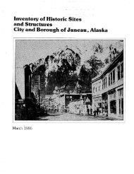
Figure 1-1. <strong>Statter</strong> <strong>Harbor</strong> <strong>Improvements</strong> <strong>Project</strong> Area <strong>and</strong> Vicinity Map ..................................... 3<br />
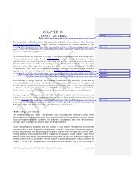
Figure 1-2. Auke Bay <strong>and</strong> Existing Conditions at <strong>Statter</strong> <strong>Harbor</strong> .................................................. 5<br />
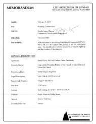
Figure 1-3. Alternative Boat Launch Ramp Locations Evaluated .................................................. 9<br />
Figure 1-4. <strong>Statter</strong> <strong>Harbor</strong> Master Plan (1995) ............................................................................. 13<br />
Figure 2-1. The Need for <strong>Improvements</strong> at <strong>Statter</strong> <strong>Harbor</strong> ........................................................... 23<br />
Figure 2-2. Existing Driveway Access to <strong>Statter</strong> <strong>Harbor</strong> from Glacier Highway ........................ 25<br />
Figure 2-3. DOT&PF Safety Issues at <strong>Statter</strong> <strong>Harbor</strong> Access Driveway (USKH 2004) .............. 26<br />
Figure 2-4. <strong>Statter</strong> <strong>Harbor</strong> Patrons Parked along Back Loop Road .............................................. 27<br />
Figure 2-5. Existing Condition <strong>of</strong> Boat Launch Ramp’s Concrete Ramp Planks ........................ 31<br />
Figure 2-6. Existing Boat Launch Ramp ...................................................................................... 32<br />
Figure 2-7. Non-motorized <strong>and</strong> Motorized Patrons Using a Single Launch Ramp ...................... 35<br />
Figure 3-1. The Area for Analysis <strong>of</strong> Upl<strong>and</strong> Parking Alternatives ............................................. 40<br />
Figure 3-2. Parcel Map Showing CBJ Ownership <strong>and</strong> Lot Numbers for All Properties within<br />
0.25-mile Radius <strong>of</strong> the Proposed Action .................................................................... 41<br />
Figure 3-3. Design Concept 1 (Dismissed from Further Analysis) .............................................. 45<br />
Figure 3-4. Design Concept 4 (Dismissed from Further Analysis) .............................................. 47<br />
Figure 3-5. Design Concept 7 (Dismissed from Further Analysis) .............................................. 51<br />
Figure 3-6. Design Concept 8 (Dismissed from Further Analysis) .............................................. 53<br />
Figure 3-7. Concept 10, Offsite Parking at Lots A77-79 with Minimal Fill Footprint at Horton<br />
Lot ................................................................................................................................ 57<br />
Figure 3-8. Numbers <strong>of</strong> Vehicle-Trailer Stalls <strong>and</strong> Estimated Costs <strong>of</strong> Design Concepts <strong>and</strong><br />
Other Alaska Launch Ramp <strong>Project</strong>s ........................................................................... 65<br />
Figure 4-1. Existing Conditions at <strong>Statter</strong> <strong>Harbor</strong> (No-Action Alternative) ................................ 71<br />
Figure 4-2. The Proposed Action Alternative ............................................................................... 75<br />
Figure 5-1. Bay Creek, View Upstream........................................................................................ 81<br />
Figure 5-2. Biotic Resources in the <strong>Project</strong> Area ......................................................................... 83<br />
Figure 5-3. Estuarine Intertidal Habitat along the North Shore <strong>of</strong> <strong>Statter</strong> <strong>Harbor</strong> ....................... 87<br />
Figure 5-4. Eelgrass Beds near the <strong>Project</strong> Area (photo provided by Pat Harris) ....................... 89<br />
Figure 6-1. Environmental Consequences <strong>of</strong> the Proposed Action ............................................ 121<br />
Figure 6-2. Environmental Consequences <strong>of</strong> the Proposed Action to Wetl<strong>and</strong>s ........................ 141<br />
Figure 6-3. Inner Auke Bay Cumulative Impacts Assessment Area .......................................... 151<br />
Figure 6-4. Greater Auke Bay Area Cumulative Impacts Assessment Area Existing Intertidal Fill<br />
<strong>and</strong> Mudflats .............................................................................................................. 153<br />
Figure 6-5. Inner Auke Bay cumulative impacts assessment area, 1929.................................... 156<br />
Figure 6-6. Inner Auke Bay cumulative impacts assessment area, 1926.................................... 157<br />
Figure 6-7. Cumulative Impacts Assessment Area, 1959 ........................................................... 159<br />
Figure 6-8. Inner Auke Bay Cumulative Impacts Assessment Area Existing Intertidal Fill <strong>and</strong><br />
Overwater Structure Footprints .................................................................................. 163<br />
HDR-249-R11012F<br />
vi
<strong>Statter</strong> <strong>Harbor</strong> <strong>Improvements</strong> <strong>Project</strong><br />
Final Environmental Assessment<br />
<br />
ABL<br />
ABLF<br />
ABCOR<br />
ABTC<br />
ACMP<br />
ADA<br />
ADEC<br />
ADF&G<br />
AHRS<br />
AHRS<br />
ASCE<br />
AWC<br />
BCC<br />
BMP<br />
CBJ<br />
CEQ<br />
CFR<br />
cfs<br />
CGP<br />
Corps<br />
CPQ<br />
CWA<br />
dBA<br />
DCOM<br />
DMLW<br />
DNR<br />
DPS<br />
DOT&PF<br />
DZ<br />
EA<br />
EFH<br />
EHW<br />
ELW<br />
EO<br />
EPA<br />
ESA<br />
ESI<br />
FAA<br />
FONSI<br />
ft-lbs<br />
ft/s<br />
GBBC<br />
Habitat<br />
HDR<br />
HRAC<br />
HDR-249-R11012F<br />
Acronyms & Abbreviations<br />
Auke Bay Laboratories<br />
Auke Bay Loading Facility<br />
Auke Bay Corridor<br />
Auke Bay Towers Condominiums<br />
Alaska Coastal Management Program<br />
Americans with Disabilities Act<br />
Alaska Department <strong>of</strong> Environmental Conservation<br />
Alaska Department <strong>of</strong> Fish <strong>and</strong> Game<br />
Alaska Heritage Resources Survey<br />
Alaska Heritage Resources Survey<br />
American Society <strong>of</strong> Civil Engineers<br />
Anadromous Waters Catalog<br />
Birds <strong>of</strong> Conservation Concern<br />
Best Management Practice<br />
<strong>City</strong> <strong>and</strong> <strong>Borough</strong> <strong>of</strong> <strong>Juneau</strong><br />
Council on Environmental Quality<br />
Code <strong>of</strong> Federal Regulations<br />
Cubic feet per second<br />
Contractor’s General Permit<br />
U.S. Army Corps <strong>of</strong> Engineers<br />
Coastal <strong>Project</strong> Questionnaire<br />
Clean Water Act<br />
Decibels<br />
Division <strong>of</strong> Coastal <strong>and</strong> Ocean Management<br />
Division <strong>of</strong> Mining, L<strong>and</strong>, <strong>and</strong> Water<br />
Alaska Department <strong>of</strong> Natural Resources<br />
Distinct population segment<br />
Alaska Department <strong>of</strong> Transportation <strong>and</strong> Public Facilities<br />
Distance Zone<br />
Environmental Assessment<br />
Essential Fish Habitat<br />
Extreme high water<br />
Extreme low water<br />
Executive Order<br />
(U.S.) Environmental Protection Agency<br />
Endangered Species Act<br />
Existing Scenic Integrity<br />
Federal Aviation Administration<br />
Finding <strong>of</strong> No Significant Impact<br />
Foot-pounds<br />
Feet per second<br />
Great Backyard Bird Count<br />
Alaska Department <strong>of</strong> Fish <strong>and</strong> Game, Division <strong>of</strong> Habitat<br />
HDR Alaska, Inc.<br />
Historical Resource Advisory Committee<br />
vii
<strong>Statter</strong> <strong>Harbor</strong> <strong>Improvements</strong> <strong>Project</strong><br />
Final Environmental Assessment<br />
HTL<br />
ISA<br />
JSD<br />
MBTA<br />
MHW<br />
MHHW<br />
MLLW<br />
MLS<br />
MMPA<br />
MSFCMA<br />
NAAQS<br />
NEPA<br />
NMFS<br />
NOAA<br />
NPS<br />
NRHP<br />
NWI<br />
ORWAP<br />
OSMB<br />
PJD<br />
PND<br />
SHPO<br />
SIO<br />
SMS<br />
SOBA<br />
Sport Fish<br />
SSC<br />
SSD<br />
SSR<br />
SWPPP<br />
TIA<br />
USCG<br />
USDA<br />
USFWS<br />
USKH<br />
VAC<br />
VPR<br />
WC<br />
High tide line<br />
Inherent Scenic Attractiveness<br />
<strong>Juneau</strong> School District<br />
Migratory Bird Treaty Act<br />
Mean high water<br />
Mean higher high water<br />
Mean lower low water<br />
Multiple Listing Service<br />
Marine Mammal Protection Act<br />
Magnuson Stevens Fishery <strong>and</strong> Conservation Management Act<br />
National Ambient Air Quality St<strong>and</strong>ards<br />
National Environmental Policy Act<br />
National Marine Fisheries Service<br />
National Oceanic <strong>and</strong> Atmospheric Administration<br />
National Park Service<br />
National Register <strong>of</strong> Historic Places<br />
National Wetl<strong>and</strong>s Inventory<br />
Oregon Rapid Wetl<strong>and</strong> Assessment Protocol<br />
Oregon State Marine Board<br />
Preliminary jurisdictional wetl<strong>and</strong>s delineation<br />
PND Engineers, Inc.<br />
State Historic Preservation Office or Officer<br />
Scenic Integrity Objective<br />
Scenery Management System<br />
States for Organized Boating Access<br />
Alaska Department <strong>of</strong> Fish <strong>and</strong> Game, Division <strong>of</strong> Sport Fish<br />
Species <strong>of</strong> Special Concern<br />
Stopping sight distance<br />
Scoping Summary Report<br />
Stormwater Pollution Protection Plan<br />
Traffic Impact Analysis<br />
U.S. Coast Guard<br />
U. S. Department <strong>of</strong> Agriculture<br />
U.S. Fish <strong>and</strong> Wildlife Service<br />
USKH, Inc.<br />
Visual Absorption Capacity<br />
Visual Priority Travel Routes <strong>and</strong> Use Areas<br />
Waterfront Commercial<br />
HDR-249-R11012F<br />
viii
<strong>Statter</strong> <strong>Harbor</strong> <strong>Improvements</strong> <strong>Project</strong><br />
Final Environmental Assessment<br />
DRAFT EA TO FINAL EA: SUMMARY OF REVISIONS<br />
The <strong>Statter</strong> <strong>Harbor</strong> <strong>Improvements</strong> <strong>Project</strong> Draft Environmental Assessment (EA) was released on<br />
April 1, 2010, <strong>and</strong> presented two alternatives—the Proposed Action <strong>and</strong> No-Action. There were<br />
88 public e-mails, comment forms, <strong>and</strong> letters <strong>and</strong> 11 agency e-mails <strong>and</strong> letters received during<br />
the comment period. More than 330 issue-specific comments were identified.<br />
Comments were classified as substantive, non-substantive, or editorial (a question or clarification<br />
required within the document). For the <strong>Statter</strong> <strong>Harbor</strong> <strong>Improvements</strong> <strong>Project</strong>, substantive<br />
comments are defined as “comments that are within the scope <strong>of</strong> the Proposed Action, that are<br />
specific to the Proposed Action, have a direct relationship to the Proposed Action, <strong>and</strong> that<br />
include supporting reasons for the Responsible Official to consider.” Comments classified as<br />
substantive received a response describing how that comment was addressed in the Final EA. A<br />
Comment Summary document summarizes all comments received <strong>and</strong> includes two tables that<br />
provide responses for each resource agency comment classified as substantive. The Comment<br />
Summary document is included as Appendix A to the Final EA.<br />
In response to comments received on the Draft EA, a number <strong>of</strong> changes were made during<br />
development <strong>of</strong> the Final EA. The CBJ collected <strong>and</strong> analyzed additional data; developed<br />
screening criteria based on project need <strong>and</strong> design guidelines; included <strong>and</strong> analyzed four<br />
additional impact categories; <strong>and</strong> updated the layout <strong>of</strong> the Proposed Action Alternative in the<br />
Final EA. The majority <strong>of</strong> revisions were made as a direct result <strong>of</strong> comments received.<br />
Revisions incorporated into the Final EA are summarized below.<br />
Additional Studies Performed<br />
The CBJ performed a number <strong>of</strong> studies in response to comment received on the Draft EA. The<br />
additional studies are listed below; information contained within each study has been<br />
incorporated in the Final EA.<br />
Launch Ramp Capacity <strong>and</strong> Efficiency Study (USKH 2011) – Provides additional information on<br />
boat launch dem<strong>and</strong>, capacity, <strong>and</strong> efficiency to ensure improvements at <strong>Statter</strong> <strong>Harbor</strong> would<br />
meet current dem<strong>and</strong>. Specifically, this study was conducted to determine 1) the <strong>Juneau</strong> area’s<br />
boat launch dem<strong>and</strong>, 2) the existing launch facilities’ capacity, <strong>and</strong> 3) the effect that existing,<br />
limited on-site parking at <strong>Statter</strong> <strong>Harbor</strong> may have on boat launch operations at that facility <strong>and</strong><br />
nearby Amalga <strong>Harbor</strong>.<br />
CBJ Launch Ramp User Survey <strong>and</strong> Dem<strong>and</strong> Forecast (McDowell Group 2010) – Provides<br />
additional information on boat launch ramp use in <strong>Juneau</strong>. The study collected area-wide launch<br />
ramp usage data <strong>and</strong> boaters’ opinions about safety <strong>and</strong> physical conditions <strong>of</strong> local launch<br />
ramps through a mail survey sent out to CBJ launch ramp permit holders. The study incorporates<br />
the user data with capacity data (USKH 2011) to estimate current launch ramp capacity.<br />
Wetl<strong>and</strong> <strong>and</strong> Intertidal Area Functional Assessment (HDR 2010a) – Provides supporting<br />
information regarding habitat function in the project area. This study describes the primary<br />
ecological functions <strong>and</strong> values those wetl<strong>and</strong>s <strong>and</strong> intertidal habitats naturally provide in the<br />
project area. This study also provides a numeric estimate <strong>of</strong> the relative ability <strong>of</strong> those habitats<br />
to support a wide variety <strong>of</strong> functions <strong>and</strong> values important to society. This estimate may be used<br />
for comparison to potential mitigation sites during the permitting process.<br />
HDR-249-R11012F<br />
ix
<strong>Statter</strong> <strong>Harbor</strong> <strong>Improvements</strong> <strong>Project</strong><br />
Final Environmental Assessment<br />
Circulation Numerical Modeling (HDR 2011). – The circulation modeling study was developed<br />
to compare <strong>and</strong> assess the potential hydrodynamic impacts <strong>of</strong> the placing fill in estuarine habitat<br />
under the Proposed Action. Information from this report is used in the Final EA to assess<br />
potential impacts to habitat in the project area.<br />
Upl<strong>and</strong>s Alternative Analysis (PND 2011a) – This report presents a comprehensive summary <strong>of</strong><br />
analyses conducted to address agencies’ concerns regarding 1) alternative locations for the<br />
proposed project <strong>and</strong> 2) <strong>of</strong>fsite upl<strong>and</strong> locations in the vicinity <strong>of</strong> the proposed project for nonwater-dependent<br />
activities. This report is described in more detail below.<br />
Scenery Resources Report (Corvus Design 2011a) – Provides supporting information relative to<br />
existing scenery resources <strong>and</strong> potential visual impacts that would result from the Proposed<br />
Action.<br />
Mud Flat Delineation Report (Corvus Design 2011b) – Provides additional information on<br />
habitat in the project area. Mud flats are considered a “Special Aquatic Site” under Federal<br />
regulations (40 CFR 230). The purpose <strong>of</strong> this study was to delineate mud flats in the project<br />
area in order to assess potential impacts <strong>of</strong> the Proposed Action. The CBJ also performed a<br />
mudflat field delineation in the greater Auke Bay area, from Smuggler’s Cove west to Auke Nu<br />
Cove.<br />
Exp<strong>and</strong>ed Cumulative Impacts Analysis – Based on comments received from NMFS on the<br />
Corps’ Public Notice <strong>of</strong> the 404/10 permit application, the area <strong>of</strong> analysis for cumulative<br />
impacts was exp<strong>and</strong>ed to include the greater Auke Bay area from Smuggler’s Cove west to Auke<br />
Nu Cove. Cumulative fill amounts were calculated based on aerial imagery from 1962, as<br />
compared with current imagery. The extent <strong>of</strong> mudflats were mapped <strong>and</strong> included with mapped<br />
extent <strong>of</strong> eelgrass beds in the area (Harris et al. 2008).<br />
Additional Off-site <strong>and</strong> Upl<strong>and</strong> Alternatives Analysis<br />
The Upl<strong>and</strong> Alternatives Analysis (PND 2011a) was developed to present a comprehensive<br />
summary <strong>of</strong> analyses conducted to address agencies’ concerns regarding 1) alternative locations<br />
for the proposed project <strong>and</strong> 2) <strong>of</strong>fsite upl<strong>and</strong> locations in the vicinity <strong>of</strong> the proposed project for<br />
non-water-dependent activities.<br />
The report begins by differentiating between those project-components that would be considered<br />
water-dependent <strong>and</strong> those not considered water-dependent, based on Corps guidelines. The<br />
report defines design requirements for each project component (e.g., number <strong>of</strong> parking spaces;<br />
boarding float dimensions) in order to ensure the project’s purpose would be met.<br />
The second part <strong>of</strong> the report includes an analysis <strong>of</strong> locations considered (in addition to <strong>Statter</strong><br />
<strong>Harbor</strong>) for potential development <strong>of</strong> the two-lane boat launch ramp <strong>and</strong> boarding float <strong>and</strong><br />
associated parking. Recognizing the high dem<strong>and</strong> at the <strong>Statter</strong> <strong>Harbor</strong> facility in light <strong>of</strong> existing<br />
congestion, as well as the distribution <strong>of</strong> the areas’ population, alternative facility locations<br />
between Mendenhall Peninsula <strong>and</strong> Indian Point were considered for this analysis.<br />
After examining other locations for siting a launch ramp facility, <strong>and</strong> finding no other locations<br />
useable or practicable, the third part <strong>of</strong> the analysis focuses on <strong>of</strong>fsite upl<strong>and</strong> parking alternatives<br />
for a facility at or near <strong>Statter</strong> <strong>Harbor</strong>. To guide the effort, properties were identified that could<br />
meet the needs <strong>of</strong> the overall project purpose by establishing a set <strong>of</strong> assumptions <strong>and</strong> criteria to<br />
HDR-249-R11012F<br />
x
<strong>Statter</strong> <strong>Harbor</strong> <strong>Improvements</strong> <strong>Project</strong><br />
Final Environmental Assessment<br />
determine 1) the extent <strong>of</strong> the area <strong>of</strong> analysis, 2) a property’s ability to be “reasonably<br />
obtained”, <strong>and</strong> 3) the usability <strong>of</strong> properties to be considered for alternatives.<br />
Multiple sites were identified <strong>and</strong> reviewed as potential alternative locations for the non-waterdependent<br />
components <strong>of</strong> the proposed project. Once useable properties were identified,<br />
preliminary site development plans were created to better determine whether they would still<br />
meet the project needs <strong>and</strong> to provide a basis for a preliminary analysis <strong>of</strong> potential impacts<br />
(PND 2011a). Ultimately, one property was found to be both reasonably available <strong>and</strong> usable.<br />
Development <strong>of</strong> lots A77-79 (i.e. Lindegaard property) is presented as Concept 10, <strong>and</strong> is<br />
screened in the Final EA.<br />
Design Criteria <strong>and</strong> Concept Screening<br />
The Final EA was updated to include design criteria <strong>of</strong> the project components (water dependent<br />
<strong>and</strong> not water dependent) necessary for the project to achieve its purpose <strong>and</strong> meet its stated<br />
needs. Design criteria were clarified to address comments regarding the development <strong>of</strong><br />
alternatives, the full range <strong>of</strong> alternatives (concepts), <strong>and</strong> the establishment <strong>of</strong> the range <strong>of</strong><br />
reasonable alternatives for detailed analysis. Design <strong>and</strong> logistical criteria for the proposed<br />
project are based on state <strong>and</strong> Corps guidelines, studies conducted for this project, <strong>and</strong> publically<br />
available data. Design criteria included requirements for 1) safe access: road width <strong>and</strong> stopping<br />
sight distances; 2) safe pedestrian access; 3) parking: dimensions <strong>and</strong> number <strong>of</strong> spaces; <strong>and</strong> 4)<br />
launch ramp <strong>and</strong> boarding float specifications: grade <strong>and</strong> tidal access, boarding float dimensions,<br />
<strong>and</strong> make-ready <strong>and</strong> tie-down areas. Design criteria are described in more detail in Section 2.2<br />
<strong>and</strong> Section 2.3. Results <strong>of</strong> the screening process are included in Section 3.<br />
Changes to the Proposed Action<br />
The layout <strong>of</strong> the Proposed Action alternative was changed slightly as compared to the Draft EA.<br />
The location <strong>of</strong> the access driveway was shifted slightly due to a DOT&PF request during a<br />
meeting on January 11, 2011 to relocate the proposed site access driveway directly opposite the<br />
Squire’s Rest driveway entrance. This relocation would provide a center turning lane on Glacier<br />
Highway <strong>and</strong> improve vehicular safety on the highway.<br />
Based on site-specific studies performed (McDowell 2010, USKH 2011) <strong>and</strong> updated guidelines<br />
(SOBA 2006), the Proposed Action was updated to provide vehicle-trailer parking stalls sized at<br />
12-feet by 50-feet in addition to vehicle-trailer parking stalls that meet minimum size<br />
requirements (e.g., 10-feet by 40-feet). Due to facility layout revisions, the revised Proposed<br />
Action’s intertidal footprint is 4.1 acres in the Final EA. Further, the Proposed Action does not<br />
propose to construct a restroom facility.<br />
Additional Impact Categories Analyzed<br />
The Final EA was updated to include the following impact categories not included in the Draft<br />
EA: L<strong>and</strong> Use (Sections 5.9 <strong>and</strong> 6.9); Recreation <strong>and</strong> Public Use (Sections 5.10 <strong>and</strong> 6.10); <strong>and</strong><br />
Air Quality (Sections 5.11 <strong>and</strong> 6.11). These sections were included in response to agency<br />
comments.<br />
HDR-249-R11012F<br />
xi
<strong>Statter</strong> <strong>Harbor</strong> <strong>Improvements</strong> <strong>Project</strong><br />
Final Environmental Assessment<br />
This page intentionally left blank.<br />
HDR-249-R11012F<br />
xii
<strong>Statter</strong> <strong>Harbor</strong> <strong>Improvements</strong> <strong>Project</strong><br />
Final Environmental Assessment<br />
1.0 INTRODUCTION<br />
The <strong>City</strong> <strong>and</strong> <strong>Borough</strong> <strong>of</strong> <strong>Juneau</strong> (CBJ) seeks to improve the safety <strong>and</strong> efficiency <strong>of</strong> its harbor<br />
operations by constructing a modern, double-lane boat launch ramp <strong>and</strong> associated parking at<br />
<strong>Statter</strong> <strong>Harbor</strong> in Auke Bay, near <strong>Juneau</strong>, Alaska (Figure 1-1). The CBJ <strong>and</strong> Alaska Department<br />
<strong>of</strong> Fish <strong>and</strong> Game (ADF&G), Division <strong>of</strong> Sport Fish (Sport Fish) have entered into a cooperative<br />
agreement (Coop. No. 08-015, ADF&G 2008a). Under this agreement, the Federal Aid in Sport<br />
Fish Restoration Act (Dingell-Johnson/Wallop-Breaux) could provide 75% <strong>of</strong> the funding to<br />
develop a boat launch ramp, parking for vehicles with boat trailers, <strong>and</strong> other associated<br />
improvements on CBJ-owned <strong>and</strong> managed l<strong>and</strong>s, <strong>and</strong> state-generated matching funds could<br />
generate the remaining 25%, if specific planning <strong>and</strong> permitting requirements are met. Under the<br />
agreement, the CBJ must prepare an Environmental Assessment (EA); produce preliminary<br />
designs; develop a project budget; obtain leases or conveyances <strong>of</strong> state or federally-owned<br />
upl<strong>and</strong>s; <strong>and</strong> secure all necessary permits <strong>and</strong> approvals.<br />
This EA presents <strong>and</strong> screens a full range <strong>of</strong> alternatives (also identified as concepts) developed<br />
as a result <strong>of</strong> comments received during scoping. Eight <strong>of</strong> ten alternatives considered were<br />
screened <strong>and</strong> dismissed from more-detailed analysis for either not being feasible to build, or not<br />
meeting the project’s intended purpose <strong>and</strong> need. Two were carried forward as project<br />
alternatives for detailed analysis in accordance with the National Environmental Policy Act<br />
(NEPA) <strong>and</strong> U.S. Fish <strong>and</strong> Wildlife Service (USFWS) NEPA Guidance to States participating in<br />
the Federal Aid Program.<br />
1.1 <strong>Project</strong> Area<br />
<strong>Statter</strong> <strong>Harbor</strong> is located approximately 12 miles west <strong>of</strong> downtown <strong>Juneau</strong> on the south side <strong>of</strong><br />
Glacier Highway, near the highway’s intersection with the Mendenhall Loop Road (Back Loop<br />
Road; Figure 1-1). <strong>Statter</strong> <strong>Harbor</strong> is one <strong>of</strong> three moorage facilities in Auke Bay (Figure 1-2).<br />
The <strong>Statter</strong> <strong>Harbor</strong> floating breakwater in Auke Bay is oriented east-west, with the entrance to<br />
the three moorage facilities located at its western end. The existing <strong>Statter</strong> <strong>Harbor</strong> facility<br />
occupies the deep-water area immediately north <strong>of</strong> the breakwater <strong>and</strong> continues along the east<br />
shore <strong>of</strong> Auke Bay north to the boat launch ramp <strong>and</strong> parking area. The other two moorage<br />
facilities within the floating breakwater include DeHart’s Marina <strong>and</strong> Fisherman’s Bend Marina.<br />
DeHart’s Marina is located north <strong>of</strong> the <strong>Statter</strong> <strong>Harbor</strong> deepwater floats <strong>and</strong> west <strong>of</strong> the <strong>Statter</strong><br />
<strong>Harbor</strong> boat launch ramp. Fisherman’s Bend Marina, a privately owned facility, is the westernmost<br />
moorage facility in Auke Bay. Fisherman’s Bend is, located north <strong>of</strong> the breakwater’s west<br />
entrance.<br />
The project area includes the existing <strong>Statter</strong> <strong>Harbor</strong> facility <strong>and</strong> DeHart’s Marina, both owned<br />
by the CBJ. The project area is bound by the CBJ Auke Bay Wastewater Treatment Facility <strong>and</strong><br />
the Auke Bay Tower Condominiums (ABTC) to the west <strong>and</strong> Glacier Highway to the north <strong>and</strong><br />
east. L<strong>and</strong> adjacent to the harbor along the south side <strong>of</strong> Glacier Highway consists <strong>of</strong> DeHart’s<br />
convenience store, two private residences, <strong>and</strong> two lots owned by CBJ (a vacant lot <strong>and</strong> the<br />
Horton Lot). The Horton Lot is currently used for parking. The upl<strong>and</strong>s occupy approximately<br />
900 feet <strong>of</strong> frontage along Glacier Highway. Available upl<strong>and</strong>s are limited <strong>and</strong> congested<br />
parking conditions persist along this segment <strong>of</strong> Glacier Highway.<br />
HDR-249-R11012F 1
<strong>Statter</strong> <strong>Harbor</strong> <strong>Improvements</strong> <strong>Project</strong><br />
Final Environmental Assessment<br />
This page intentionally left blank.<br />
HDR-249-R11012F 2
<strong>Statter</strong> <strong>Harbor</strong><br />
MENDENHALL<br />
LOOP RD<br />
River<br />
Mendenhall<br />
Lake<br />
A L A S K A<br />
<strong>Statter</strong> <strong>Harbor</strong><br />
<strong>Improvements</strong><br />
<strong>Project</strong><br />
<strong>Project</strong> Area<br />
<strong>and</strong> Vicinity<br />
GLACIER HWY<br />
AMHS<br />
Ferry<br />
Terminal<br />
Auke Bay<br />
Loading Facility<br />
Auke<br />
Lake<br />
Mendenhall<br />
Gulf <strong>of</strong> Alaska<br />
<strong>Juneau</strong><br />
!<br />
Figure 1-1<br />
LEGEND<br />
<strong>Project</strong> Area<br />
A u k e B a y<br />
<strong>Juneau</strong> International<br />
Airport<br />
EGAN DR<br />
M en d e n h al l<br />
P en i n su l a<br />
F r i t z<br />
C o v e<br />
N DOUGLAS HWY<br />
G a s t i n e a u C h a n n e l<br />
Klukwan<br />
!<br />
Skagway<br />
!<br />
CANADA<br />
Elfin Cove<br />
!<br />
Pelican<br />
!<br />
!<br />
Haines<br />
<strong>Statter</strong> <strong>Harbor</strong><br />
Gustavus<br />
!<br />
Hoonah<br />
!<br />
<strong>Juneau</strong><br />
!<br />
Tenakee Springs<br />
!<br />
D o u g l a s I s l a n d<br />
JUNEAU<br />
!<br />
Ë<br />
Miles<br />
0 0.5 1 1.5 2<br />
Datum: NAD 1927<br />
Coordinate System: Albers<br />
Sources: DOT, HDR, GINA<br />
Author: HDR Alaska, Inc.<br />
Date: May 19, 2011<br />
!
<strong>Statter</strong> <strong>Harbor</strong> <strong>Improvements</strong> <strong>Project</strong><br />
Final Environmental Assessment<br />
This page intentionally left blank.<br />
HDR-249-R11012F 4
GLACIER HIGHWAY<br />
Auke Bay<br />
Elementary School<br />
Bay Creek<br />
Horton<br />
Lot<br />
Squire's Rest<br />
CBJ Shelter<br />
Lehnhart<br />
Property<br />
Deem's<br />
Property<br />
BACKLOOP RD<br />
DeHart's<br />
Convenience<br />
Store<br />
<strong>Statter</strong> <strong>Harbor</strong><br />
<strong>Improvements</strong><br />
<strong>Project</strong><br />
Auke Bay <strong>and</strong><br />
Existing Conditions<br />
at <strong>Statter</strong> <strong>Harbor</strong><br />
Figure 1-2<br />
LEGEND<br />
Auke Bay Tower<br />
Condominiums<br />
Boat<br />
Yard<br />
AUKE BAY<br />
HARBOR RD<br />
Stream<br />
Eelgrass Beds<br />
Fisherman's<br />
Bend<br />
Marina<br />
DeHart's<br />
Marina<br />
Boat Launch<br />
Parking Area<br />
<strong>Statter</strong><br />
<strong>Harbor</strong><br />
GLACIER HIGHWAY<br />
Note: Aerial photography<br />
provided by PND Engineers, Inc.,<br />
dated June 9, 2006.<br />
Ë<br />
Feet<br />
Breakwater<br />
NOAA NMFS<br />
Auke Bay Laboratory<br />
0 100 200 300 400<br />
Datum: NAD 1983<br />
Coordinate System: AK State Plane Zone 1<br />
Sources: PND<br />
Author: HDR Alaska, Inc.<br />
Date: May 19, 2011
<strong>Statter</strong> <strong>Harbor</strong> <strong>Improvements</strong> <strong>Project</strong><br />
Final Environmental Assessment<br />
This page intentionally left blank.<br />
HDR-249-R11012F 6
<strong>Statter</strong> <strong>Harbor</strong> <strong>Improvements</strong> <strong>Project</strong><br />
Final Environmental Assessment<br />
The upl<strong>and</strong> properties are zoned Waterfront Commercial (WC); however, some <strong>of</strong> the properties<br />
are currently being utilized as residences. Though the proposed <strong>Statter</strong> <strong>Harbor</strong> improvements fall<br />
within the allowable l<strong>and</strong> use code for the WC zoning district, the CBJ would still require a<br />
conditional l<strong>and</strong> use permit.<br />
1.1.1 Existing <strong>Harbor</strong> Use in Auke Bay<br />
Recreational boating, commercial fishing, <strong>and</strong> sport fishing are significant summer activities in<br />
the CBJ, with boating activities occurring primarily in the waters north <strong>and</strong> west <strong>of</strong> <strong>Juneau</strong>. The<br />
area’s major harbors are located in downtown <strong>Juneau</strong>. Consequently, boats with permanent<br />
berths in <strong>Juneau</strong> <strong>of</strong>ten seek temporary moorage at private marinas or the public dock in Auke<br />
Bay.<br />
There are two public moorage facilities in Auke Bay (DeHart’s Marina <strong>and</strong> <strong>Statter</strong> <strong>Harbor</strong>); one<br />
private marina (Fisherman’s Bend); one public launching ramp (<strong>Statter</strong> <strong>Harbor</strong>); <strong>and</strong> one<br />
operational floating fueling station (DeHart’s Marina; Figure 1-2). Located west <strong>of</strong> <strong>Statter</strong><br />
<strong>Harbor</strong>, the Auke Bay Loading Facility (ABLF; Figure 1-1) provides marine loading facilities for<br />
commercial operations.<br />
Facility use at Auke Bay is largely seasonal. During the winter, commercial vessels comprise the<br />
majority <strong>of</strong> boats utilizing the Auke Bay facilities. During the spring, the total number <strong>of</strong> vessels<br />
moored at the facilities is divided between commercial <strong>and</strong> recreational vessels. The number <strong>of</strong><br />
temporarily-moored recreational vehicles increases significantly during the summer, while the<br />
number <strong>of</strong> commercial vessels declines. Conversely, the numbers <strong>of</strong> commercial vessels in Auke<br />
Bay increases substantially during in-season troll closures.<br />
The following activities occur at <strong>Statter</strong> <strong>Harbor</strong>:<br />
• Moorage (year-round)<br />
• Moorage for all types <strong>of</strong> boats, including pleasure, commercial, <strong>and</strong> fishing<br />
• Moorage for U.S. Coast Guard (USCG) emergency response <strong>and</strong> patrol vessels<br />
• Moorage for local emergency response vessels<br />
• Parking for moorage<br />
• Parking for local businesses<br />
Recreation (seasonal)<br />
• Yacht <strong>and</strong> fishing boat viewing (year-round)<br />
• Sport-fishing charter departures (spring, summer, <strong>and</strong> autumn)<br />
• Whale-watching charter <strong>and</strong> tour departures (spring <strong>and</strong> summer)<br />
• Kayak <strong>and</strong> canoe rental (summer)<br />
• Boat rental (summer)<br />
Miscellaneous (year-round)<br />
• Vessel sewage holding tank pump-out facility<br />
• Load/unload cargo <strong>and</strong> supplies from vessels<br />
• Marine service <strong>and</strong> repair<br />
HDR-249-R11012F 7
1.2 <strong>Project</strong> Background<br />
<strong>Statter</strong> <strong>Harbor</strong> <strong>Improvements</strong> <strong>Project</strong><br />
Final Environmental Assessment<br />
This section provides a brief history <strong>of</strong> the extensive planning efforts undertaken by the CBJ to<br />
provide infrastructure to support <strong>Juneau</strong>’s varied harbor needs. Section 1.2.1 summarizes<br />
previous planning efforts that ultimately identified the need to separate recreational <strong>and</strong><br />
commercial users. Section 1.2.1 also summarizes the site selection process used to determine<br />
project locations <strong>and</strong>, more specifically, how <strong>Statter</strong> <strong>Harbor</strong> was ultimately chosen to serve<br />
recreational <strong>and</strong> light commercial users (e.g., passenger for-hire operators; Appendix B; PND<br />
2011a). Section 1.2.2 describes previous planning efforts that identified improvement needs<br />
specific to recreational <strong>and</strong> light commercial users at <strong>Statter</strong> <strong>Harbor</strong>.<br />
1.2.1 Site Selection to Satisfy <strong>Juneau</strong>’s <strong>Harbor</strong> Needs<br />
The CBJ assembly has acknowledged the inadequacy <strong>of</strong> the marine loading facilities for<br />
commercial operations in <strong>Juneau</strong> <strong>and</strong> the long history <strong>of</strong> congestion, conflicting uses, <strong>and</strong> public<br />
safety concerns at <strong>Statter</strong> <strong>Harbor</strong> (PND 2006). The CBJ held two public meetings in 2002 <strong>and</strong><br />
four user group workshops in 2003 to identify <strong>and</strong> discuss key issues <strong>and</strong> facility needs (PND<br />
2006). The four user groups included light cargo (e.g., miscellaneous supplies, food, <strong>and</strong><br />
construction material delivery), commercial fishing operators, recreational boaters, <strong>and</strong><br />
passenger for-hire operators (e.g., whale watching tours, sport fishing charters).<br />
The new harbor site was originally envisioned to satisfy the needs <strong>of</strong> all four user groups.<br />
However, based on input gathered during the meetings <strong>and</strong> workshops, it was apparent that a<br />
two-site solution would be more appropriate to satisfy the community’s needs (PND 2006). The<br />
two-site solution would separate “industrial” from “recreational” users to increase safety;<br />
provide infrastructure to support commercial fisheries <strong>and</strong> related businesses in <strong>Juneau</strong>; allow<br />
tourism business to grow while keeping impacts separate from other harbor users; provide a safe<br />
<strong>and</strong> secure regional freight facility; <strong>and</strong> meet existing recreational user dem<strong>and</strong> at <strong>Statter</strong> <strong>Harbor</strong><br />
(PND 2006).<br />
The CBJ team evaluated multiple sites in the Auke Bay area from Mendenhall Peninsula to<br />
Indian Point for the proposed ABLF (2006). In addition to <strong>Statter</strong> <strong>Harbor</strong>, potential locations<br />
included Fritz Cove, Stabler’s Point, the Lindegaard Property (west <strong>of</strong> <strong>Statter</strong> <strong>Harbor</strong>), the<br />
Alaska Glacier Seafoods lot, <strong>and</strong> the Auke Bay Lot 1 <strong>and</strong> adjacent tidel<strong>and</strong>s site. These locations<br />
were considered in part for their access to water <strong>and</strong> proximity to other facilities.<br />
The Assembly placed a bond issue on the October 2005 ballot to include, among other<br />
improvement projects, funds for development <strong>of</strong> a commercial loading facility in Auke Bay;<br />
<strong>Juneau</strong> voters subsequently approved the bond obligation. The Auke Bay Lot 1 <strong>and</strong> adjacent<br />
tidel<strong>and</strong>s site in Auke Nu Cove was ultimately chosen for construction <strong>of</strong> the ABLF (PND<br />
2006).<br />
As part <strong>of</strong> the ABLF site selection process, it was determined that recreational <strong>and</strong> passenger forhire<br />
users would remain at <strong>Statter</strong> <strong>Harbor</strong> (PND 2006). However, the CBJ also considered other<br />
sites (alternative to <strong>Statter</strong> <strong>Harbor</strong>) to satisfy recreational users <strong>and</strong> passenger for-hire needs<br />
(PND 2011a).<br />
As part <strong>of</strong> the alternatives development process for this EA, CBJ re-evaluated alternative<br />
locations for the boat launch ramp. Each site’s geographical location relative to the center <strong>of</strong><br />
<strong>Juneau</strong>’s greater population was an important consideration when determining which alternative<br />
site locations to analyze. In 2010, almost two-thirds <strong>of</strong> <strong>Juneau</strong>’s population lived between Lena<br />
HDR-249-R11012F 8
<strong>Statter</strong> <strong>Harbor</strong> <strong>Improvements</strong> <strong>Project</strong><br />
Final Environmental Assessment<br />
Cove <strong>and</strong> Salmon Creek. An estimated one-fifth <strong>of</strong> <strong>Juneau</strong> households used a CBJ launch facility<br />
in 2010, <strong>and</strong> <strong>Statter</strong> <strong>Harbor</strong> accounted for approximately one quarter <strong>of</strong> all launches in that year<br />
(McDowell 2010). Moreover, if the <strong>Statter</strong> facility were built to States for Organized Boating<br />
Access (SOBA) st<strong>and</strong>ards <strong>and</strong> not congested or considered unsafe by existing <strong>and</strong> potential<br />
users, <strong>Statter</strong> would likely have accounted for substantially more launches.<br />
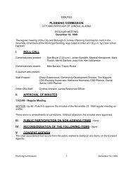
Recognizing the high dem<strong>and</strong> at the <strong>Statter</strong> <strong>Harbor</strong> facility in light <strong>of</strong> existing congestion, as well<br />
as the distribution <strong>of</strong> the areas’ population, alternative facility locations between Mendenhall<br />
Peninsula <strong>and</strong> Indian Point were evaluated (Figure 1-3; PND 2011a).<br />
Lena Cove<br />
Auke Nu Cove<br />
Lindegaard<br />
Property<br />
<strong>Statter</strong> <strong>Harbor</strong><br />
Indian Point<br />
Stabler’s Point<br />
Mendenhall<br />
Peninsula<br />
Fritz Cove<br />
Mendenhall<br />
Wetl<strong>and</strong>s<br />
Salmon Creek<br />
Figure 1-3. Alternative Boat Launch Ramp Locations Evaluated<br />
The Upl<strong>and</strong> Alternative Analysis (PND 2011a) provides a thorough discussion <strong>of</strong> locations<br />
evaluated. Based on results <strong>of</strong> the Upl<strong>and</strong> Alternative Analysis, the CBJ confirmed that the<br />
<strong>Statter</strong> <strong>Harbor</strong> area the most feasible site for development <strong>of</strong> a boat launch ramp (PND 2011a).<br />
Table 1-1 summarizes screening results for the five alternative locations to <strong>Statter</strong> <strong>Harbor</strong>. After<br />
taking a hard look at other locations for siting a launch ramp facility, <strong>and</strong> finding no other<br />
locations useable or practicable, the Upl<strong>and</strong> Alternative Analysis focused on upl<strong>and</strong> alternatives<br />
for a facility at or near <strong>Statter</strong> <strong>Harbor</strong>, as summarized in Section 3.2 <strong>of</strong> this EA <strong>and</strong> provided in<br />
Appendix B.<br />
HDR-249-R11012F 9
<strong>Statter</strong> <strong>Harbor</strong> <strong>Improvements</strong> <strong>Project</strong><br />
Final Environmental Assessment<br />
Alternative<br />
Locations<br />
Stabler’s<br />
Point<br />
Lindegaard<br />
Property<br />
Mendenhall<br />
Peninsula<br />
(Fritz Cove)<br />
Auke Nu<br />
Cove<br />
Indian Point<br />
Highway access<br />
Difficult access due<br />
to steep grade, poor<br />
sight distances <strong>and</strong><br />
high speed traffic.<br />
Poor sight distances,<br />
steep road grades<br />
difficult for access<br />
driveway<br />
development.<br />
No current access,<br />
requires road,<br />
utilities, <strong>and</strong> upl<strong>and</strong>s<br />
area be developed.<br />
Introduces traffic to<br />
narrow residential<br />
road with insufficient<br />
shoulder width, etc.<br />
Accessible via<br />
Glacier Highway.<br />
Requires extensive<br />
access improvements.<br />
Table 1-1 Screening Summary <strong>of</strong> Alternative Locations for a Boat Launch Ramp<br />
Property Ownership,<br />
Zoning & Cost<br />
Limited upl<strong>and</strong>s.<br />
Bathymetry shows steep<br />
subsurface. Site<br />
conditions require that a<br />
facility be created almost<br />
entirely <strong>of</strong> fill in waters<br />
<strong>of</strong> the U.S. Owned by<br />
CBJ.<br />
Three adjoining lots, not<br />
owned by CBJ.<br />
Shallow bathymetry<br />
would require extensive<br />
fill to reach waters below<br />
ELW. Surrounding l<strong>and</strong><br />
owned by the CBJ.<br />
Surrounded by ABLF,<br />
Auke Bay Ferry<br />
Terminal <strong>and</strong> Alaska<br />
Glacier Seafoods, Inc.<br />
Four parcels, most<br />
undeveloped, <strong>and</strong><br />
Glacier Bay National<br />
Park facility, a cemetery,<br />
<strong>and</strong> recreational trail.<br />
Environmental &<br />
Other Concerns<br />
Significant exposure to waves<br />
(5-foot); fetch length 9 miles.<br />
Site conditions require that a<br />
facility be created almost<br />
entirely <strong>of</strong> fill in waters <strong>of</strong> the<br />
U.S.<br />
Significant exposure to waves<br />
(5-foot), wake, <strong>and</strong> chop; fetch<br />
length 9 miles. Requires wave<br />
barrier. Requires 4.85 acres <strong>of</strong><br />
fill in Waydelich Creek estuarine<br />
delta. Impacts 0.8 acres <strong>of</strong><br />
eelgrass beds.<br />
Near Mendenhall Wetl<strong>and</strong>s State<br />
Game Refuge. Known Bald<br />
Eagle nesting trees. Requires fill<br />
in Mendenhall River. The CBJ<br />
anticipates significant objection<br />
to development near refuge.<br />
Eelgrass conservation easement<br />
in progress.<br />
The CBJ anticipates significant<br />
objection to development in or<br />
near areas <strong>of</strong> cultural<br />
significance.<br />
Reason for Dismissal<br />
Dismissed due to logistical challenges <strong>and</strong> cost <strong>of</strong><br />
extensive access <strong>and</strong> upl<strong>and</strong> improvements. Impacts to<br />
waters <strong>of</strong> the U.S. would be greater than the proposed<br />
<strong>Statter</strong> <strong>Harbor</strong> project.<br />
Impacts would be greater (relative to proposed <strong>Statter</strong><br />
<strong>Harbor</strong> project) to waters <strong>of</strong> the U.S. <strong>and</strong> Waydelich<br />
Creek alluvial delta. Cost <strong>of</strong> development<br />
($14,856,000) considered excessive compared to other<br />
similar facilities constructed in Alaska.<br />
Dismissed due to logistical challenges <strong>and</strong> costs <strong>of</strong> the<br />
required extensive upl<strong>and</strong>, utilities, <strong>and</strong> access<br />
improvements. Level <strong>of</strong> impacts to waters <strong>of</strong> the U.S.<br />
<strong>and</strong> the environment would be greater than that <strong>of</strong> the<br />
proposed <strong>Statter</strong> <strong>Harbor</strong> project.<br />
Development not possible due to conservation<br />
easement restrictions for 31.96 acres at Auke Nu cove<br />
(Corps Permit No. POA-2005-2019-2).<br />
Dismissed due to logistical challenges <strong>and</strong> costs <strong>of</strong><br />
access improvements, <strong>and</strong> significant impacts to<br />
cultural resources (known native burial grounds <strong>and</strong><br />
culturally modified trees). Site recommended for<br />
placement on the National Register <strong>of</strong> Historic Places.<br />
HDR-249-R11012F 10
<strong>Statter</strong> <strong>Harbor</strong> <strong>Improvements</strong> <strong>Project</strong><br />
Final Environmental Assessment<br />
1.2.2 <strong>Improvements</strong> Identified for <strong>Statter</strong> <strong>Harbor</strong><br />
The CBJ has long recognized the need for improvements at <strong>Statter</strong> <strong>Harbor</strong> <strong>and</strong> has worked to<br />
accomplish that objective. <strong>Harbor</strong> usage has increased steadily over the last two decades due to<br />
the harbor’s location near a large population base <strong>and</strong> its popularity with locals <strong>and</strong> visitors.<br />
<strong>Harbor</strong> infrastructure <strong>and</strong> facility upgrades, however, have not kept pace with the dem<strong>and</strong>s <strong>of</strong> the<br />
harbor’s diverse commercial <strong>and</strong> recreational users. In 2001—2002, the parking area was<br />
exp<strong>and</strong>ed with a marine seawall, pedestrian improvements, <strong>and</strong> a new harbor <strong>of</strong>fice. Despite<br />
these improvements, the congestion, caused primarily by limited harbor space, <strong>of</strong>ten triggers<br />
conflicts between various patrons <strong>of</strong> the facility.<br />
In 2005, the <strong>Harbor</strong> Board purchased DeHart’s Marina for the potential development <strong>of</strong> moorage<br />
<strong>and</strong> a commercial tour loading facility at <strong>Statter</strong> <strong>Harbor</strong>. DeHart’s Marina is adjacent to <strong>Statter</strong><br />
<strong>Harbor</strong> <strong>and</strong> was constructed in 1980. A detailed condition assessment <strong>of</strong> DeHart’s Marina<br />
concluded that most <strong>of</strong> the existing floats were considered to be in poor condition; some<br />
components were rated as fair 1 (PND 2004). The floats at DeHart’s Marina have reached the end<br />
<strong>of</strong> their operational life <strong>and</strong> some floats are sinking. The needs to upgrade, reconfigure, <strong>and</strong>/or<br />
replace existing facilities at <strong>Statter</strong> <strong>Harbor</strong> <strong>and</strong> DeHart’s Marina have been identified by the CBJ<br />
as a top priority.<br />
The CBJ formed a Steering Committee 2 to identify improvements for <strong>Statter</strong> <strong>Harbor</strong> <strong>and</strong> to<br />
provide direction to the CBJ Docks <strong>and</strong> <strong>Harbor</strong>s Department. The <strong>Statter</strong> <strong>Harbor</strong> Master Plan<br />
was developed to address the needs <strong>of</strong> the facility’s recreational boaters <strong>and</strong> for-hire operators.<br />
The Master Plan received Steering Committee approval on June 7, 2005 <strong>and</strong> was subsequently<br />
adopted by the CBJ (2005b).<br />
The Master Plan outlines extensive <strong>and</strong> comprehensive improvements to address harbor use <strong>and</strong><br />
issues, <strong>and</strong> to guide long term development <strong>of</strong> the area. The Plan incorporated a multi-use<br />
concept to serve the diverse user groups efficiently <strong>and</strong> safely, <strong>and</strong> to redevelop the upl<strong>and</strong>s as a<br />
mixed marine, commercial, <strong>and</strong> public use area. <strong>Improvements</strong> outlined in the Master Plan<br />
included new moorage facilities; boat launch ramps; kayak ramps; tour bus staging <strong>and</strong> vessel<br />
loading areas; separated facilities for tour operations <strong>and</strong> boat moorage; exp<strong>and</strong>ed upl<strong>and</strong>s to<br />
improve circulation <strong>and</strong> parking for automobiles, boat trailers, passenger vehicles, <strong>and</strong> buses;<br />
vessel haul-out services; trails <strong>and</strong> public open spaces; restrooms <strong>and</strong> telephones; retail<br />
enterprises; <strong>and</strong> beach access, a sea walk, <strong>and</strong> improved pedestrian corridors (Figure 1-4).<br />
1 PND (2004) defined “poor” condition as functional, but with significant deterioration <strong>and</strong> an estimated life <strong>of</strong> 2 to<br />
5 years, <strong>and</strong> “fair” condition as functional, but with damage <strong>and</strong> an estimated life <strong>of</strong> 5 to 10 years. The assessment<br />
included cost estimates for two scenarios: replacement <strong>and</strong> rehabilitation <strong>of</strong> the marina.<br />
2 The Master Plan Committee comprised representatives from the Parks <strong>and</strong> Recreation Department <strong>and</strong> Advisory<br />
Committee, the <strong>Harbor</strong>s Board, tour industries, the Docks <strong>and</strong> <strong>Harbor</strong>s Department, Jensen Yorba Lott consulting<br />
firm, the CBJ’s Community Development Department, <strong>and</strong> from various State <strong>of</strong> Alaska environmental permitting<br />
<strong>and</strong> project funding agencies.<br />
HDR-249-R11012F 11
<strong>Statter</strong> <strong>Harbor</strong> <strong>Improvements</strong> <strong>Project</strong><br />
Final Environmental Assessment<br />
This page intentionally left blank.<br />
HDR-249-R11012F 12
<strong>Statter</strong> <strong>Harbor</strong><br />
<strong>Improvements</strong><br />
<strong>Project</strong><br />
<strong>Statter</strong> <strong>Harbor</strong><br />
Master Plan (1995)<br />
Figure 1-4<br />
1995 Master Plan<br />
Parking Specifications<br />
102 Trailer Parking<br />
54 Passenger Vehicle Parking<br />
3 Charter Bus Parking<br />
2 Tour Bus Loading<br />
8 Boat Storage<br />
Ë<br />
Sources: PND, CBJ<br />
Author: HDR Alaska, Inc.<br />
Date: May 19, 2011
<strong>Statter</strong> <strong>Harbor</strong> <strong>Improvements</strong> <strong>Project</strong><br />
Final Environmental Assessment<br />
This page intentionally left blank.<br />
HDR-249-R11012F 14
<strong>Statter</strong> <strong>Harbor</strong> <strong>Improvements</strong> <strong>Project</strong><br />
Final Environmental Assessment<br />
In summary, components <strong>of</strong> the <strong>Statter</strong> <strong>Harbor</strong> Master Plan are to:<br />
• Construct a modern double-lane boat launch ramp <strong>and</strong> associated parking<br />
• Construct a new access driveway from Glacier Highway for vehicles with trailers<br />
• Construct a sea walk trail near Bay Creek<br />
• Construct marine seawall to retain additional fill<br />
• Reconfigure vehicular access <strong>and</strong> traffic circulation in the harbor area<br />
• Segregate kayak launch operations from motorboat launch operations<br />
• Relocate the covered shelter <strong>and</strong> create a scenic overlook<br />
• Construct a restroom<br />
• Install l<strong>and</strong>scaped buffer areas near adjacent properties<br />
• Maintain the existing boat launch ramp to accommodate kayak <strong>and</strong> light vessel use<br />
• Remove the DeHart’s Marina float system<br />
• Perform system maintenance on existing moorage floats, wave attenuator, <strong>and</strong> anchoring<br />
system<br />
• Exp<strong>and</strong> moorage system with new main floats, dedicated stalls, <strong>and</strong> utilities to <strong>of</strong>fset<br />
capacity losses at DeHart’s Marina<br />
• Provide fuel distribution at the new floats<br />
• Install a passenger for-hire boarding float to support tour <strong>and</strong> light commercial loading<br />
operations<br />
• Provide lease space for retail in the harbor area<br />
• Provide potential lease space for retail in the upl<strong>and</strong>s adjacent to Glacier Highway<br />
The CBJ obtained funding from Sport Fish through Dingell-Johnson/Wallop-Breaux for portions<br />
<strong>of</strong> the Plan’s prescribed improvements. Due to the project cost <strong>and</strong> size, multiyear Federal Aid<br />
funding would be needed to meet the Sport Fish portion <strong>of</strong> the project costs. Because Federal<br />
funding is being used for this project, the project must comply with NEPA. Formal scoping was<br />
conducted to identify issues <strong>and</strong> this EA was prepared to evaluate various <strong>Statter</strong> <strong>Harbor</strong><br />
improvement alternatives (HDR 2008).<br />
1.3 The NEPA Process<br />
The CBJ <strong>and</strong> Sport Fish have entered into a cooperative agreement, the purpose <strong>of</strong> which is to<br />
improve public recreational boating <strong>and</strong> sport fishing access to the marine waters <strong>of</strong> <strong>Juneau</strong> by<br />
completing planning activities for the future construction <strong>of</strong> a boat ramp <strong>and</strong> related facility at<br />
<strong>Statter</strong> <strong>Harbor</strong>. Because federal funding is involved, one <strong>of</strong> those planning requirements<br />
specified in the cooperative agreement is the preparation <strong>of</strong> an EA. The CBJ initiated this EA to<br />
analyze the proposed harbor improvements, in compliance with NEPA <strong>and</strong> in accordance with<br />
USFWS guidelines 3 .<br />
The guidance indicates that “if an action is not categorically excluded, an EA must be prepared<br />
to discuss alternative actions to meet the needs <strong>of</strong> the grants <strong>and</strong> to examine the effects <strong>of</strong> those<br />
actions with sufficient evidence <strong>and</strong> analysis to determine whether to prepare an [Environmental<br />
3 USFWS NEPA Guidance to States participating in the Federal Aid Program<br />
HDR-249-R11012F 15
<strong>Statter</strong> <strong>Harbor</strong> <strong>Improvements</strong> <strong>Project</strong><br />
Final Environmental Assessment<br />
Impact Statement] EIS”. If the action would have a significant impact on the environment,<br />
preparation <strong>of</strong> an EIS is required. If not, a Finding <strong>of</strong> No Significant Impact (FONSI) will be<br />
documented <strong>and</strong> an EIS is not necessary. The guidance indicates that the need to prepare an EIS<br />
is a matter <strong>of</strong> pr<strong>of</strong>essional judgment, <strong>and</strong> there is no absolute guidance available regarding<br />
whether an action’s impact to the human environment would be considered significant.<br />
The guidance provides a set <strong>of</strong> criteria to help determine whether an EIS may be necessary, <strong>and</strong><br />
the criteria are listed below in Table 1-2. Based on the answers in Table 1-2, an EIS is not<br />
necessary for this project.<br />
Table 1-2 Criteria Suggesting the Need to Prepare <strong>and</strong> EIS<br />
Does the following apply to this project?<br />
Controversy over environmental effects (e.g., major scientific or technical disputes over one or<br />
more environmental effects)<br />
Precedent-setting actions with wide-reaching or long-term implications (e.g., mineral<br />
extraction)<br />
Major alterations <strong>of</strong> natural environmental quality that may exceed local, state, or federal<br />
environmental st<strong>and</strong>ards<br />
Exposing existing or future generations to increased safety or health hazards<br />
Conflicts with substantially proposed or adopted local, regional, State, interstate, or Federal l<strong>and</strong><br />
use plans or policies, that may result in adverse environmental effects<br />
Adverse effects on designated or proposed natural or recreation areas, such as wilderness areas,<br />
parks, research areas, <strong>and</strong> wild <strong>and</strong> scenic rivers<br />
Removal <strong>of</strong> production <strong>of</strong> prime <strong>and</strong> unique agricultural l<strong>and</strong>s, as designated by local, regional,<br />
state, or federal authorities<br />
Adverse effects on municipal, industrial, or agricultural water supply or quality; or major<br />
consumptive use <strong>of</strong> other long-term commitment <strong>of</strong> water<br />
Condemnation <strong>of</strong> property rights or fee title to l<strong>and</strong>; or large-scale relocation <strong>of</strong> people, homes,<br />
commercial, industrial, or major public facilities<br />
Major proposals establishing new refuge system units, fish hatcheries, or major additions to<br />
existing installations<br />
Master or comprehensive conservation plans for major new installations, or for established<br />
installations, where major new developments or substantial changes in management practices<br />
are proposed<br />
Yes or No<br />
1.3.1 Cooperating <strong>and</strong> Participating Agencies<br />
Following NEPA guidelines, the project team has identified federal, state, <strong>and</strong> local agencies<br />
(referred to as “participating agencies”) that have jurisdiction by law or special expertise related<br />
to the various environmental issues. These agencies’ input was solicited during the scoping<br />
period to assess the project’s potential environmental impacts. Table 1-3 lists the participating<br />
agencies involved with this project.<br />
No<br />
No<br />
No<br />
No<br />
No<br />
No<br />
No<br />
No<br />
No<br />
No<br />
No<br />
HDR-249-R11012F 16
Participating Agency<br />
Alaska Department <strong>of</strong> Fish <strong>and</strong><br />
Game (ADF&G)<br />
Division <strong>of</strong> Habitat4 (Habitat)<br />
Division <strong>of</strong> Sport Fish<br />
Alaska Department <strong>of</strong> Natural<br />
Resources (DNR) including:<br />
State Historic Preservation Office<br />
(SHPO)<br />
Division <strong>of</strong> Mining, L<strong>and</strong> <strong>and</strong><br />
Water, L<strong>and</strong> Resources (DMLW)<br />
Environmental Protection Agency<br />
(EPA)<br />
Federal Aviation Administration<br />
(FAA)<br />
National Oceanic <strong>and</strong> Atmospheric<br />
Administration (NOAA) Fisheries<br />
Protected Resources Division<br />
Habitat Conservation Division<br />
National Marine Fisheries<br />
Service (NMFS) Alaska Fisheries<br />
Science Center Auke Bay<br />
Laboratories (ABL)<br />
U.S. Fish <strong>and</strong> Wildlife Service<br />
(USFWS)<br />
U.S. Army Corps <strong>of</strong> Engineers<br />
Table 1-3 Participating Agencies’ Jurisdiction/Expertise<br />
<strong>Statter</strong> <strong>Harbor</strong> <strong>Improvements</strong> <strong>Project</strong><br />
Final Environmental Assessment<br />
Jurisdiction/Expertise<br />
ADF&G is the State <strong>of</strong> Alaska department that manages Alaska’s fish <strong>and</strong><br />
wildlife resources.<br />
The Division <strong>of</strong> Habitat protects Alaska’s fish <strong>and</strong> wildlife resources <strong>and</strong><br />
their habitats.<br />
The Division <strong>of</strong> Sport Fish manages Alaska’s recreational fisheries <strong>and</strong><br />
builds facilities for boater <strong>and</strong> angler access to those fisheries.<br />
DNR is the State <strong>of</strong> Alaska department charged with the development,<br />
conservation, <strong>and</strong> enhancement <strong>of</strong> natural resources.<br />
SHPO is consulted to comply with Section 106 <strong>of</strong> the National Historic<br />
Preservation Act <strong>and</strong> Executive Order (EO) 13175.<br />
DMLW oversees the use <strong>and</strong> protection <strong>of</strong> Alaska's state-owned l<strong>and</strong> <strong>and</strong><br />
water.<br />
The EPA has broad oversight <strong>and</strong> implementing responsibility for many<br />
laws, including the Clean Water Act. This includes Sections 402 <strong>and</strong> 404 <strong>of</strong><br />
the Clean Water Act. Also, Section 309 <strong>of</strong> the CAA requires the review <strong>and</strong><br />
written comment by EPA <strong>of</strong> major federal actions, which may include EAs.<br />
The EPA does not rate EAs, however, only EISs.<br />
The FAA regulates civil aviation to promote safety; encourages <strong>and</strong> develops<br />
civil aeronautics, including new aviation technology; develops <strong>and</strong> operating<br />
a system <strong>of</strong> air traffic control <strong>and</strong> navigation for both civil <strong>and</strong> military<br />
aircraft; researches <strong>and</strong> develops the National Airspace System <strong>and</strong> civil<br />
aeronautics; develops <strong>and</strong> implements programs to control aircraft noise <strong>and</strong><br />
other environmental effects <strong>of</strong> civil aviation; <strong>and</strong> regulates U.S. commercial<br />
space transportation.<br />
NOAA Fisheries are responsible for the nation’s living marine resources <strong>and</strong><br />
their habitat.<br />
NOAA’s Protected Resources Division is responsible for developing<br />
management <strong>and</strong> conservation programs for marine mammals under the<br />
guidance <strong>of</strong>: the Marine Mammal Protection Act (MMPA), the Endangered<br />
Species Act (ESA), the Fur Seal Act, <strong>and</strong> the Magnuson-Stevens Fishery<br />
Conservation Act.<br />
The Habitat Conservation Division oversees avoiding <strong>and</strong> minimizing<br />
adverse effects to living marine resources <strong>and</strong> essential fish habitat (EFH)<br />
resulting from human activities.<br />
The Alaska Fisheries Science Center is the research branch <strong>of</strong> the NOAA’s<br />
NMFS responsible for research on living marine resources in the coastal<br />
oceans <strong>of</strong>f Alaska <strong>and</strong> parts <strong>of</strong> the west coast <strong>of</strong> the United States. The ABL<br />
conducts scientific research throughout Alaska on fish stocks, fish habitats,<br />
<strong>and</strong> the chemistry <strong>of</strong> marine environments involved in managing natural<br />
resources.<br />
The USFWS administers the ESA, manages migratory bird populations,<br />
restores nationally significant fisheries, <strong>and</strong> conserves <strong>and</strong> restores wildlife<br />
habitat such as wetl<strong>and</strong>s.<br />
The Corps is responsible for the nation’s aquatic resources <strong>and</strong> administers<br />
4 DNR Office <strong>of</strong> Habitat Management <strong>and</strong> Permitting became the Division <strong>of</strong> Habitat, a part <strong>of</strong> ADF&G, effective<br />
July 1, 2008, as a result <strong>of</strong> Executive Order 114.<br />
HDR-249-R11012F 17
<strong>Statter</strong> <strong>Harbor</strong> <strong>Improvements</strong> <strong>Project</strong><br />
Final Environmental Assessment<br />
Participating Agency<br />
(Corps)<br />
U.S. Coast Guard (USCG)<br />
Sector <strong>Juneau</strong> (17-37360)<br />
Jurisdiction/Expertise<br />
the Rivers <strong>and</strong> <strong>Harbor</strong>s Act <strong>and</strong> the Clean Water Act. Regulatory authority is<br />
based on Section 10 <strong>of</strong> the Rivers <strong>and</strong> <strong>Harbor</strong>s Act <strong>of</strong> 1899 (22 USC 403),<br />
which prohibits the obstruction or alteration <strong>of</strong> navigable waters <strong>of</strong> the U.S.5<br />
without a permit from the Corps; <strong>and</strong> Section 404 <strong>of</strong> the Clean Water Act,<br />
which prohibits the discharge <strong>of</strong> dredged or fill material into waters <strong>of</strong> the<br />
U.S., including wetl<strong>and</strong>s, without a Corps permit.<br />
The USCG is responsible for approval <strong>of</strong> the location <strong>and</strong> plans <strong>of</strong> bridges<br />
<strong>and</strong> causeways constructed across navigable waters <strong>of</strong> the United States.<br />
1.3.2 Determination <strong>of</strong> Issues/Non-Issues<br />
Issues to be addressed in the EA were determined through a project scoping process <strong>and</strong> by<br />
implementing steps outlined in the USFWS NEPA Guidance to States participating in the<br />
Federal Aid Program.<br />
The USFWS guidance identifies impact categories (i.e., issue categories) that could potentially<br />
be analyzed in the EA. The guidance indicates that the EA should only include descriptions <strong>of</strong><br />
biological, physical, social, <strong>and</strong> economic conditions pertinent to the actions addressed in the<br />
alternatives section <strong>and</strong> the impacts addressed in the environmental consequences chapters. In<br />
other words, the EA should not include a description <strong>of</strong> the environment at large.<br />
Based on careful consideration <strong>of</strong> agency <strong>and</strong> public comments, <strong>and</strong> preliminary research <strong>and</strong><br />
field investigations, some impact topics listed in the guidance document are not included in the<br />
EA. Table 1-4 lists those categories that were excluded from analysis in this EA because they<br />
either do not pertain to the project or have not risen to a level <strong>of</strong> importance to merit inclusion in<br />
the analysis.<br />
5 Waters <strong>of</strong> the U.S. include water bodies regulated by Corps, including wetl<strong>and</strong>s, navigable waters, lakes, ponds,<br />
<strong>and</strong> streams.<br />
HDR-249-R11012F 18
Animal Welfare<br />
Coastal Barriers<br />
Coastal Zone<br />
Resource Category<br />
Economic Effects<br />
Energy/Mineral Resources<br />
Environmental Justice<br />
Exotic or Non-indigenous Species<br />
Farml<strong>and</strong> (prime or unique)<br />
Floodplains<br />
Indian Sacred Sites or Trust<br />
Resources<br />
International Effects<br />
Table 1-4 Impact Categories Excluded from EA Analysis<br />
<strong>Statter</strong> <strong>Harbor</strong> <strong>Improvements</strong> <strong>Project</strong><br />
Final Environmental Assessment<br />
Rationale for Exclusion<br />
The proposed project would not effect the treatment <strong>of</strong> dogs, cats <strong>and</strong> other<br />
animals used for research, experimentation, exhibition, sale purposes, or<br />
treatment <strong>of</strong> animals during transportation in commerce.<br />
There are no coastal barriers in Alaska.<br />
The proposed project lies within the coastal zone. The State <strong>of</strong> Alaska no<br />
longer has a coastal management program. Therefore, the proposed project<br />
will be reviewed for consistency with the Coastal Management Act.<br />
The harbor is adjacent to local business, a private harbor, <strong>and</strong> residents.<br />
There could be potential impacts to business, both positive <strong>and</strong> negative.<br />
However, because <strong>Statter</strong> <strong>Harbor</strong> is an existing facility, economic impacts<br />
would not be significant, so a detailed analysis will not be completed.<br />
The EA does not address impacts to energy/mineral resources because the<br />
project would not affect energy/mineral resources.<br />
The EA does not address environmental justice because there are no<br />
environmental justice populations that would be disproportionally or<br />
adversely affected by the project.<br />
The project would not promote the introduction <strong>of</strong> exotic or non-indigenous<br />
species to the project area. Fill material would be used during construction <strong>of</strong><br />
the proposed improvements. Best management practices (BMPs) to avoid the<br />
introduction <strong>of</strong> exotic or non-indigenous species will be identified during the<br />
permitting phase.<br />
There are no unique or prime farml<strong>and</strong>s in the State <strong>of</strong> Alaska.<br />
The EA does not address impacts to floodplains because floodplain functions<br />
would not be impacted by the project.<br />
Indian Sacred Sites or Trust Resources are not located in the project area.<br />
The project would not have an international effect.<br />
Soil Effects<br />
The EA does not address impacts to soil because the project will not have an<br />
impact on soils.<br />
Wild <strong>and</strong> Scenic Rivers There are no wild <strong>and</strong> scenic rivers in the project area (NPS 2008).<br />
Wastes (hazardous <strong>and</strong> solid)<br />
The project will not generate hazardous or solid waste beyond the local<br />
l<strong>and</strong>fill’s h<strong>and</strong>ling capability.<br />
HDR-249-R11012F 19
<strong>Statter</strong> <strong>Harbor</strong> <strong>Improvements</strong> <strong>Project</strong><br />
Final Environmental Assessment<br />
This page intentionally left blank.<br />
HDR-249-R11012F 20
<strong>Statter</strong> <strong>Harbor</strong> <strong>Improvements</strong> <strong>Project</strong><br />
Final Environmental Assessment<br />
2.0 PURPOSE AND NEED<br />
2.1 Purpose for Action<br />
The purpose <strong>of</strong> the proposed <strong>Statter</strong> <strong>Harbor</strong> <strong>Improvements</strong> <strong>Project</strong> is to improve safety <strong>and</strong><br />
reduce congestion by increasing harbor efficiency through incorporation <strong>of</strong> improvement plans<br />
identified in the <strong>Statter</strong> <strong>Harbor</strong> Master Plan. The project’s purpose to improve safety <strong>and</strong><br />
efficiency is driven by the needs for:<br />
• Safe access to the harbor<br />
• Improved pedestrian access<br />
• Adequate onsite parking<br />
• Increased boat launch capacity <strong>and</strong><br />
efficiency<br />
• Reduced congestion<br />
• Separated user groups<br />
Satisfying these needs would act to meet existing user dem<strong>and</strong>. The need for proposed<br />
improvement plans are further illustrated in Figure 2-1.<br />
Under existing conditions, commercial boats, recreational motorboats, <strong>and</strong> kayaks share a<br />
deteriorated two-lane boat launch in a congested area, which creates unsafe conditions <strong>and</strong><br />
results in long waiting times. The use <strong>of</strong> the existing launch facility is limited during low tides<br />
because the concrete ramp surface does not extend to sufficient water depth. The inability for<br />
boat launch operations to occur during extreme low tides causes traffic backups in the parking<br />
lot. Additionally, some <strong>of</strong> the harbor’s older moorage facilities are in need <strong>of</strong> repair or<br />
replacement.<br />
The <strong>Statter</strong> <strong>Harbor</strong> <strong>Improvements</strong> <strong>Project</strong> purpose <strong>and</strong> need <strong>and</strong> related concerns are summarized<br />
in Table 2-1. A detailed discussion <strong>of</strong> the improvement needs as identified during the planning<br />
process is summarized in the sections that follow.<br />
Table 2-1 Summary <strong>of</strong> Purpose <strong>of</strong> <strong>and</strong> Need for Proposed <strong>Statter</strong> <strong>Harbor</strong> <strong>Improvements</strong><br />
Purpose Need Concern<br />
Provide safe access Existing access drive from Glacier Highway is unsafe.<br />
to harbor<br />
Improve<br />
Safety<br />
Reduce<br />
Congestion/<br />
Increase<br />
Efficiency<br />
Improve safety <strong>of</strong><br />
pedestrian access<br />
Provide adequate<br />
onsite parking<br />
Increase boat launch<br />
capacity<br />
Separate user groups<br />
The existing parking <strong>and</strong> facility layout does not provide adequate pedestrian<br />
walkways to separate automobile <strong>and</strong> pedestrian traffic <strong>and</strong> therefore<br />
presents safety concerns.<br />
Existing users are <strong>of</strong>ten forced to park <strong>of</strong>fsite in potentially unsafe areas,<br />
such as along Glacier Highway, along the Back Loop Road, <strong>and</strong> across the<br />
highway at the Auke Bay Elementary School. These <strong>of</strong>fsite parking options<br />
will not be available in the near future <strong>and</strong> only 22 trailer stalls are available<br />
onsite.<br />
Facility users experience long wait times to use the existing boat launch due<br />
to high use <strong>and</strong> inability to conduct launch operations during extreme low<br />
tides.<br />
Conflicts between “light” commercial users <strong>and</strong> recreational users <strong>of</strong>ten<br />
arise; separation would minimize this problem.<br />
HDR-249-R11012F 21
<strong>Statter</strong> <strong>Harbor</strong> <strong>Improvements</strong> <strong>Project</strong><br />
Final Environmental Assessment<br />
This page intentionally left blank.<br />
HDR-249-R11012F 22
Lack <strong>of</strong> pedestrian pathways to connect <strong>of</strong>fsite<br />
parking to harbor creates safety concerns<br />
Insufficient vehicle/trailer parking stalls forces overflow<br />
parking onto Backloop Road <strong>and</strong> other <strong>of</strong>fsite locations,<br />
causing unsafe conditions along roadways. It also<br />
increases time for launch <strong>and</strong> retrieve operations.<br />
GLACIER HIGHWAY<br />
!O<br />
rj<br />
Overflow parking from existing harbor<br />
spills onto Glacier Hwy, Backloop Rd,<br />
<strong>and</strong> Auke Bay Elementary School<br />
parking lot <strong>and</strong> creates safety concerns.<br />
BACKLOOP RD<br />
<strong>Statter</strong> <strong>Harbor</strong><br />
<strong>Improvements</strong><br />
<strong>Project</strong><br />
The Need for<br />
<strong>Improvements</strong><br />
Figure 2-1<br />
LEGEND<br />
rj Conflict Areas<br />
Insufficient Parking<br />
!O Areas<br />
Overflow Parking<br />
Motorized <strong>and</strong> non-motorized boats launching from the same<br />
boat ramp causes conflicts <strong>and</strong> creates unsafe conditions<br />
Existing boat launch ramp cannot be used<br />
by motor boats during extreme low tides<br />
Intersection into harbor identified by ADOT&PF<br />
as a safety concern due to limited visibility<br />
<strong>and</strong> subst<strong>and</strong>ard stopping sight distances<br />
One-way access to boat launch ramp creates<br />
congestion <strong>and</strong> long wait times for users<br />
Lack <strong>of</strong> pedestrian/vehicle separation<br />
creates conflicts <strong>and</strong> safety concerns<br />
!O<br />
rj<br />
rj<br />
!O<br />
rj<br />
GLACIER HIGHWAY<br />
rj<br />
AUKE BAY<br />
HARBOR RD<br />
Ë<br />
Feet<br />
0 75 150 225 300<br />
Datum: NAD 1983<br />
Coordinate System: AK State Plane Zone 1<br />
Sources: PND, HDR,<br />
Author: HDR Alaska, Inc.<br />
Date: May 19, 2011
<strong>Statter</strong> <strong>Harbor</strong> <strong>Improvements</strong> <strong>Project</strong><br />
Final Environmental Assessment<br />
This page intentionally left blank.<br />
HDR-249-R11012F 24
<strong>Statter</strong> <strong>Harbor</strong> <strong>Improvements</strong> <strong>Project</strong><br />
Final Environmental Assessment<br />
2.2 Need for Action<br />
2.2.1 Safe Access to <strong>Harbor</strong><br />
The current access driveway into <strong>Statter</strong> <strong>Harbor</strong>, located next to the DeHart’s Convenience Store<br />
<strong>of</strong>f Glacier Highway, has been a safety concern <strong>of</strong> Alaska Department <strong>of</strong> Transportation <strong>and</strong><br />
Public Facilities (DOT&PF) for many years (DOT&PF 2008). The access driveway’s limited<br />
visibility <strong>and</strong> less than desirable stopping sight distance (SSD) cause unsafe conditions (Figure<br />
2-1). For example, the <strong>Statter</strong> <strong>Harbor</strong> driveway currently has an up-hill grade for vehicles exiting<br />
the facility, which results in slow-moving boat trailers entering Glacier Highway. These slowmoving<br />
vehicles pose a risk as they cross traffic onto Glacier Highway heading west, as well as<br />
those trying to accelerate up grade if heading east. These conditions are further exacerbated by<br />
the poor stopping sight distances at the driveway intersection.<br />
In addition to being located on a curve with poor stopping distances, the driveway’s location is<br />
further complicated by its proximity to the Back Loop Road intersection. The ABCOR study<br />
identifies the intersection <strong>of</strong> the existing access with Glacier Highway as an area <strong>of</strong> conflict for<br />
vehicular traffic (Figure 2-2). The intersection <strong>of</strong> the Glacier Highway <strong>and</strong> Back Loop Road has<br />
a high collision rate <strong>and</strong> significant rear-end collision frequency (USKH 2004). The ABCOR<br />
study identified the need to upgrade plans at the intersection by potentially constructing a<br />
roundabout (USKH 2004). The DOT&PF is currently developing a project that would include<br />
construction <strong>of</strong> a roundabout at the Glacier Highway <strong>and</strong> Back Loop Road<br />
intersection (USKH 2009).<br />
EXISTING ACCESS DRIVE<br />
Existing access to <strong>Statter</strong> <strong>Harbor</strong> is unsafe due<br />
to less than desirable stopping sight distances.<br />
Figure 2-2. Existing Driveway Access to <strong>Statter</strong> <strong>Harbor</strong> from Glacier Highway<br />
HDR-249-R11012F 25
<strong>Statter</strong> <strong>Harbor</strong> <strong>Improvements</strong> <strong>Project</strong><br />
Final Environmental Assessment<br />
The need for improved access to <strong>Statter</strong> <strong>Harbor</strong>, primarily as it relates to safety, has been<br />
identified through various planning efforts. The proposed project improvements for <strong>Statter</strong><br />
<strong>Harbor</strong> would change the current traffic patterns in Auke Bay by relocating Glacier Highway<br />
access to the boat launch. A new driveway for vehicles with boat trailers would alleviate some <strong>of</strong><br />
the safe access concerns shared by the DOT&PF.<br />
2.2.1.1 Design criteria<br />
Access driveways to boat launch facilities typically consist <strong>of</strong> two lanes totaling 24 feet in<br />
drivable width (PND 2011a). Additional width will be necessary for turning lanes, drainage<br />
ditches, shoulders, pedestrian walkways, etc. Access driveways should be designed provided to<br />
allow for maximum visibility <strong>and</strong> adequate stopping sight distances with grades less than 10%<br />
(PND 2011a).<br />
2.2.2 Improved Pedestrian Access<br />
The existing pedestrian access to <strong>and</strong> within <strong>Statter</strong> <strong>Harbor</strong> has been identified as a safety<br />
concern (Figure 2-3). The existing harbor parking <strong>and</strong> facility layout has few pedestrian<br />
walkways to separate automobile <strong>and</strong> pedestrian traffic. The ABCOR study identified safety<br />
concerns associated with pedestrian traffic crossing Glacier Highway; <strong>and</strong> indicated many<br />
pedestrians in the area are harbor users who park <strong>of</strong>fsite (USKH 2004).<br />
Figure 2-3. DOT&PF Safety Issues at <strong>Statter</strong> <strong>Harbor</strong> Access Driveway (USKH 2004)<br />
As discussed below in Section 2.2.3, harbor users <strong>of</strong>ten park <strong>of</strong>fsite due to limited onsite parking.<br />
The Auke Bay Elementary School, located on the north side <strong>of</strong> Glacier Highway, is used as<br />
overflow parking for vehicles with trailers. There are no pedestrian pathways to connect these<br />
unmarked <strong>of</strong>fsite parking areas to <strong>Statter</strong> <strong>Harbor</strong>. The lack <strong>of</strong> pedestrian walkways causes the<br />
existing boat launch users to walk along the access drive from the boat launch ramp to Glacier<br />
Highway, walk west along the highway, <strong>and</strong> cross the highway to retrieve their vehicles.<br />
HDR-249-R11012F 26
<strong>Statter</strong> <strong>Harbor</strong> <strong>Improvements</strong> <strong>Project</strong><br />
Final Environmental Assessment<br />
Providing pedestrian walkways <strong>and</strong> a seawalk along the harbor <strong>and</strong> Bay Creek would improve<br />
safety conditions at <strong>Statter</strong> <strong>Harbor</strong>.<br />
2.2.2.1 Design criteria<br />
<strong>Harbor</strong>s need to provide pathways as a safe route for pedestrians moving from parking areas to<br />
harbor facilities. Pedestrian pathways at <strong>Statter</strong> <strong>Harbor</strong> should provide safe travel between<br />
parking areas <strong>and</strong> boat launch ramp, seawalk, <strong>and</strong> Bay Creek access trail.<br />
2.2.3 Adequate Onsite Parking<br />
<strong>Statter</strong> <strong>Harbor</strong> does not currently have adequate parking for harbor users. Onsite parking at<br />
<strong>Statter</strong> <strong>Harbor</strong> is <strong>of</strong>ten full <strong>and</strong> the existing insufficient parking facilities at <strong>Statter</strong> <strong>Harbor</strong> cause<br />
users to park in unsigned <strong>and</strong>/or non-delineated spaces, such as along the Glacier Highway<br />
(Figure 2-4), thereby creating safety concerns. <strong>Harbor</strong> users also commonly park along the<br />
eastern <strong>and</strong> western shoulders <strong>of</strong> Back Loop Road; in a gravel parking lot (i.e., Horton Lot area)<br />
on the south side <strong>of</strong> Glacier Highway; <strong>and</strong> at Auke Bay Elementary School, which is located on<br />
the north side <strong>of</strong> Glacier Highway. Insufficient onsite vehicle/trailer parking also increases time<br />
for launch <strong>and</strong> retrieve operations. The current parking configuration does not provide adequate<br />
onsite parking <strong>and</strong> safe access to the harbor for vehicles or pedestrians.<br />
Insufficient parking at <strong>Statter</strong> <strong>Harbor</strong> results in users parking<br />
in unsafe areas such as along Back Loop Road. View looking<br />
south toward Glacier Highway intersection.<br />
Figure 2-4. <strong>Statter</strong> <strong>Harbor</strong> Patrons Parked along Back Loop Road<br />
There are several reasons why the existing overflow parking situation for <strong>Statter</strong> <strong>Harbor</strong> users is<br />
inadequate. Most importantly, it is simply not safe for cars, trucks, <strong>and</strong> trailers to park on the<br />
shoulder <strong>of</strong> Glacier Highway <strong>and</strong> Back Loop Road. These roads were not designed to have<br />
vehicles parked on their shoulders <strong>and</strong> do not provide pedestrians with safe access to the harbor.<br />
The DOT&PF opposes use <strong>of</strong> these roads’ shoulders for parking (DOT&PF 2009). Moreover,<br />
DOT&PF plans to improve the roads near the harbor by increasing road widths <strong>and</strong> adding a<br />
roundabout (i.e., traffic circle) at the intersection <strong>of</strong> Glacier Highway <strong>and</strong> Back Loop Road<br />
(DOT&PF 2009). Continued use <strong>of</strong> the shoulders <strong>of</strong> these roads for overflow parking will not be<br />
provided as part <strong>of</strong> planned road improvements.<br />
HDR-249-R11012F 27
<strong>Statter</strong> <strong>Harbor</strong> <strong>Improvements</strong> <strong>Project</strong><br />
Final Environmental Assessment<br />
Although there has been ongoing use <strong>of</strong> the Auke Bay School parking lot by harbor patrons for<br />
years, the harbor does not have a formal agreement with the <strong>Juneau</strong> School District for this use<br />
(JSD 2009). The <strong>Juneau</strong> School District is unable to enter into any formal agreement with the<br />
<strong>Harbor</strong> that would allow permanent use <strong>of</strong> the school parking lot for overflow parking<br />
(JSD 2009). Furthermore, the parking lot will not be consistently available for overflow parking<br />
in the short term, due to upcoming remodeling activities planned for Auke Bay School<br />
(JSD 2009). Construction is scheduled to begin during the summer <strong>of</strong> 2011 <strong>and</strong> will continue for<br />
two to three years. During construction, the parking lot will be occupied by the building<br />
contractor <strong>and</strong> materials. In the long term, the school district is concerned with <strong>Statter</strong> <strong>Harbor</strong><br />
overflow use <strong>of</strong> its facility <strong>and</strong> the conflicting needs <strong>of</strong> existing summer programs 6 (JSD 2009).<br />
Therefore, overflow parking at Auke Bay School will not be available during the short term or<br />
long term.<br />
PND conducted a preliminary parking assessment at <strong>Statter</strong> <strong>Harbor</strong> <strong>and</strong> adjacent <strong>of</strong>fsite parking<br />
to determine the number <strong>of</strong> vehicle-trailer parking stalls necessary to meet existing parking<br />
dem<strong>and</strong> (PND 2008a). PND gathered field counts <strong>of</strong> the existing parking spaces used or<br />
available in the harbor vicinity. Existing onsite parking includes the original <strong>Statter</strong> <strong>Harbor</strong> lot,<br />
DeHart’s Marina, <strong>and</strong> DeHart’s boat yard. Offsite parking areas include Horton’s Lot, Auke Bay<br />
Elementary School, <strong>and</strong> road shoulders <strong>of</strong> the Back Loop Road.<br />
At present, <strong>Statter</strong> <strong>Harbor</strong> can accommodate 22 vehicle-trailer combination stalls onsite <strong>and</strong><br />
another 66 <strong>of</strong>fsite7, for a total <strong>of</strong> 88 existing vehicle-trailer stalls (Table 2-2; PND 2008a).<br />
However, on busy weekends parking has been observed farther up Back Loop Road <strong>and</strong> along<br />
side streets, suggesting that peak parking dem<strong>and</strong> is greater than 88 stalls 8 . Based on PND’s<br />
capacity estimates, existing onsite <strong>and</strong> <strong>of</strong>fsite parking areas provide space for approximately<br />
209 9 passenger vehicles, 88 vehicles with trailers, 8 boats, <strong>and</strong> 6 vans (Table 2-2). It is important<br />
to note that the impact from the combined loss <strong>of</strong> <strong>Statter</strong> <strong>Harbor</strong>’s current <strong>of</strong>fsite parking (i.e.,<br />
Auke Bay School <strong>and</strong> DOT&PF road shoulders) will decrease <strong>Statter</strong> <strong>Harbor</strong>’s vehicle-trailer<br />
capacity to 30 stalls as early as summer 2011 (PND 2011a).<br />
6 Summer programs at Auke Bay School include RALLY (childcare), summer school classes, <strong>and</strong> BASE programs<br />
(for at risk students; JSD 2009).<br />
7 The locations where vehicles can park are not necessarily delineated as parking spaces, such as road shoulders;<br />
therefore, the number <strong>of</strong> spaces provided is only an estimate <strong>of</strong> vehicle capacity (PND 2008a).<br />
8 As part <strong>of</strong> the capacity study PND estimated that on a typical summer weekday, all <strong>of</strong> the onsite parking spaces<br />
<strong>and</strong> overflow parking spaces along the shoulders were occupied, <strong>and</strong> that approximately 75% <strong>of</strong> the parking spaces<br />
at Auke Bay School were occupied.<br />
9 PND did not determine how many passenger vehicles were using <strong>Statter</strong> <strong>Harbor</strong> at the time <strong>of</strong> the survey. It is<br />
probable that some portion <strong>of</strong> passenger vehicles parked in these areas were not using <strong>Statter</strong> <strong>Harbor</strong>. Therefore, the<br />
number <strong>of</strong> passenger vehicle spaces needed to accommodate <strong>Statter</strong> <strong>Harbor</strong> users may be fewer than 209.<br />
HDR-249-R11012F 28
<strong>Statter</strong> <strong>Harbor</strong> <strong>Improvements</strong> <strong>Project</strong><br />
Final Environmental Assessment<br />
Table 2-2 Summary <strong>of</strong> Existing Onsite <strong>and</strong> Offsite Parking for <strong>Statter</strong> <strong>Harbor</strong> Users<br />
Existing Onsite Parking Capacity<br />
Cars Trailers Boats Vans<br />
Original <strong>Statter</strong> <strong>Harbor</strong> Lot 92 22 — 3<br />
DeHart’s Marina <strong>and</strong> Boat Yard 23 — 8 3<br />
Onsite Parking Totals 115 22 8 6<br />
Existing Offsite Parking Capacity Estimate<br />
Cars Trailers Boats Vans<br />
Horton Lot <strong>and</strong> ROW 63 8 — —<br />
Auke Bay Elementary School 25 30 — —<br />
Back Loop Road: East shoulder 3 18 — —<br />
Back Loop Road: West shoulder 3 10 — 3<br />
Offsite Parking Totals 94 66 — —<br />
Existing Parking Capacity Estimates for <strong>Statter</strong> <strong>Harbor</strong> Users<br />
Cars Trailers Boats Vans<br />
Onsite Parking Totals 115 22 8 6<br />
Offsite Parking Totals 94 66 — —<br />
Total Parking Capacity 209 88 8 6<br />
Offsite parking contributes to the harbor’s overall inefficiency. For example, users who launch<br />
their boat at <strong>Statter</strong> <strong>Harbor</strong> but cannot park onsite must leave their boat tied up along the<br />
boarding float while finding an <strong>of</strong>fsite parking space <strong>and</strong> returning to the facility. USKH (2011)<br />
estimated the extra time spent parking <strong>and</strong> retrieving vehicles reduces the capacity <strong>of</strong> each float<br />
by 0.9 boats per hour. This inefficient process results in congestion at the launch ramp <strong>and</strong> users<br />
having to wait longer than would otherwise be necessary to perform launch <strong>and</strong> retrieve<br />
operations.<br />
2.2.3.1 Design criteria<br />
It is assumed that each boat launching activity that occurs at <strong>Statter</strong> <strong>Harbor</strong> will result in the need<br />
to park a vehicle trailer combination, <strong>and</strong> that this need should be provided as part <strong>of</strong> the new<br />
facility. Under the funding agreements for this project, the construction <strong>of</strong> a boat launch requires<br />
a minimum number <strong>of</strong> parking spaces for each boat launch lane. The ADF&G uses SOBA<br />
guidelines for Alaska facilities (2006). These guidelines recommend that 50 vehicle trailer stalls<br />
be provided for each lane <strong>of</strong> the boat launch ramp in high-use areas, such as <strong>Statter</strong> <strong>Harbor</strong>.<br />
Therefore, the proposed two-lane boat launch ramp would require a minimum <strong>of</strong> 100 vehicle<br />
trailer stalls. Additionally, the Oregon State Marine Board (OSMB) recommends meeting the<br />
peak day dem<strong>and</strong> <strong>and</strong> the USKH (2011) <strong>and</strong> McDowell (2010) studies support exp<strong>and</strong>ing the<br />
existing 88 parking stalls to 100 to achieve this recommendation. The Corps recommends<br />
providing 100 pull-through lanes for a two-lane boat launch ramp. Based on well established<br />
guidelines <strong>and</strong> site specific studies conducted for this project, the proposed two-lane boat launch<br />
ramp should provide a minimum <strong>of</strong> 100 vehicle-trailer stalls (Table 2-3). These stalls would be<br />
in addition to passenger-only vehicle stalls.<br />
HDR-249-R11012F 29
Source<br />
ADF&G (2006)<br />
SOBA (2006)<br />
OSMB<br />
(1992, 2003)<br />
Table 2-3 Trailer Parking Stall Recommendation<br />
Trailer Stalls Recommended for<br />
Two-Lane Boat Launch Ramp<br />
40 minimum, 100 preferred<br />
60—100 depending on turnover<br />
rate (lower turnover rates, i.e.,<br />
boats in the water for long periods<br />
<strong>of</strong> time, require more stalls)<br />
Meet peak day dem<strong>and</strong><br />
<strong>Statter</strong> <strong>Harbor</strong> <strong>Improvements</strong> <strong>Project</strong><br />
Final Environmental Assessment<br />
Comments/Rationale<br />
Meets ADFG design guidance for high<br />
use facility<br />
Low turnover rates at <strong>Statter</strong> <strong>Harbor</strong><br />
would require the greater number <strong>of</strong><br />
stalls<br />
USKH (2011) <strong>and</strong> McDowell (2010)<br />
studies support exp<strong>and</strong>ing inadequate<br />
existing 88 parking stalls<br />
Corps (1974) 100 pull-through lanes Meets Corps design guidance<br />
Recommendation<br />
for Trailer Stalls<br />
100<br />
Satisfies all established guidelines <strong>and</strong><br />
site specific dem<strong>and</strong> studies<br />
McDowell (2010) reports that 52% <strong>of</strong> the vessels launched in the CBJ are over 18 feet in length.<br />
Approximately 60% <strong>of</strong> the vehicles used to launch vessels greater than 19 in length (McDowell<br />
2010) 10 . Trailers used for transport are longer than the vessel hauled, <strong>and</strong> the boat motor<br />
typically adds a few feet to the vessel length. Therefore, trailer spaces on average should be<br />
roughly 5 feet longer than vessel length. Based on these findings, at least 75% <strong>of</strong> the vehicle<br />
trailer stalls should be sized 12 feet by 50 feet <strong>and</strong> the remaining stalls should be the minimum<br />
size <strong>of</strong> 10 feet by 40 feet (ADF&G 2006).<br />
The OSMB recommends providing passenger only vehicle stalls to support trailer operations.<br />
These guidelines recommend 30% <strong>of</strong> the total number <strong>of</strong> vehicle-trailer stalls should be provided<br />
for car parking stalls. Based on the recommendation that 100 vehicle-trailer stalls be provided, a<br />
total <strong>of</strong> 30 car parking stalls would be necessary (PND 2011a).<br />
In addition to passenger only vehicle stalls to support trailer operations, the <strong>Statter</strong> <strong>Harbor</strong><br />
<strong>Improvements</strong> project will require an adequate number <strong>of</strong> car parking stalls to support vessel<br />
moorage use for both <strong>Statter</strong> <strong>Harbor</strong> <strong>and</strong> DeHart’s Marina. Based on design guidelines (Table<br />
2-4) the average recommended number <strong>of</strong> car parking stalls required to meet the moorage use<br />
dem<strong>and</strong>s <strong>of</strong> this site would be 208 stalls, or 238 stalls when both boat ramp <strong>and</strong> moorage users<br />
are considered. There is already capacity for 159 car parking stalls at <strong>Statter</strong> <strong>Harbor</strong> <strong>and</strong><br />
DeHart’s Marina. Therefore, an additional 79 car parking stalls (49 for vessel slips <strong>and</strong> 30 for<br />
boat launch ramp) would need to be planned with the development <strong>of</strong> any onsite boat launch<br />
ramp at <strong>Statter</strong> <strong>Harbor</strong>.<br />
10 A mail survey was sent to a list <strong>of</strong> 2010 launch ramp permit holders in the CBJ; competed surveys were received<br />
from 204 launch ramp users (McDowell 2010).<br />
HDR-249-R11012F 30
Source<br />
ASCE<br />
DOT&PF<br />
Corps<br />
<strong>Statter</strong> <strong>Harbor</strong> <strong>Improvements</strong> <strong>Project</strong><br />
Final Environmental Assessment<br />
Table 2-4 Car Parking Stall Recommendations Specific to Moorage Use<br />
Car Stalls Recommended<br />
for Boat Ramp Use<br />
0.75:1 parking stalls: vessel<br />
stalls<br />
0.5 to 0.8 parking stalls:<br />
vessel stalls<br />
0.75:1 parking stalls: vessel<br />
stalls<br />
Recommendation for Car Stalls Specific<br />
to Moorage Use<br />
Application <strong>of</strong> Design<br />
Guidelines to <strong>Statter</strong> <strong>Harbor</strong><br />
Comments/Rationale<br />
218 Meets ASCE design guidance<br />
188 Used average ratio = 0.65:1<br />
218<br />
Used Corps normal vessel<br />
distribution ratio(3:1 recommended<br />
for larger vessels)<br />
208 Average <strong>of</strong> all guidelines<br />
2.2.3.2 Increased Boat Launch Capacity <strong>and</strong> Efficiency<br />
<strong>Statter</strong> <strong>Harbor</strong> currently has a two-lane boat launch ramp that is in deteriorated condition.<br />
Concrete ramp planks are heavily spalled <strong>and</strong> exhibit exposed rebar. The ramp is too short <strong>and</strong><br />
currently not usable at all tidal levels <strong>and</strong> the timber boarding float is at the end <strong>of</strong> its useful life<br />
(Figure 2-5). <strong>Statter</strong> <strong>Harbor</strong>’s boat launch ramp is situated in a congested area, near the base <strong>of</strong><br />
the only existing access driveway into the harbor (Figure 2-1). Providing a modern double-lane<br />
boat launch ramp with sufficient ramp depth <strong>and</strong> length for launch <strong>and</strong> retrieve operations to<br />
meet current dem<strong>and</strong> has been identified as a need for <strong>Statter</strong> <strong>Harbor</strong>.<br />
Existing boat launch ramp has spalled<br />
concrete ramp planks <strong>and</strong> exposed rebar.<br />
Figure 2-5. Existing Condition <strong>of</strong> Boat Launch Ramp’s Concrete Ramp Planks<br />
Permanent <strong>and</strong> temporary moorage slips <strong>and</strong> boat trailer, passenger, <strong>and</strong> commercial vehicle<br />
parking are located on either side <strong>of</strong> the existing boat launch ramp (Figure 1-2). A boat yard<br />
facility <strong>and</strong> boat haul-out are located just east <strong>of</strong> the boat launch ramp (Figure 1-2). The spatial<br />
location <strong>of</strong> the existing boat-launch ramp <strong>and</strong> its congested nature result in unsafe <strong>and</strong> inefficient<br />
conditions in the harbor. The process <strong>of</strong> launching <strong>and</strong> retrieving boats at the existing boat<br />
launch ramp is challenging <strong>and</strong> intimidating.<br />
HDR-249-R11012F 31
<strong>Statter</strong> <strong>Harbor</strong> <strong>Improvements</strong> <strong>Project</strong><br />
Final Environmental Assessment<br />
<strong>Harbor</strong> users are <strong>of</strong>ten required to wait for long periods to use the boat launch ramp, especially<br />
from May through September during sport-fishing <strong>and</strong> hunting seasons, weekends, <strong>and</strong> extreme<br />
low tides. The existing boat launch ramp cannot be used by motor boats during extreme low tides<br />
due to the limited extent <strong>of</strong> the ramp planks (Figure 2-6). Further, the lack <strong>of</strong> adequate makeready<br />
<strong>and</strong> tie-down areas results in longer queue times.<br />
Existing boat launch ramp does not extend into the lower tidal<br />
range, <strong>and</strong> cannot be used by motor boats during extreme low tides.<br />
Figure 2-6. Existing Boat Launch Ramp<br />
The CBJ first began charging fees for launching in 1985. Since 1985, boat launch use has<br />
increased dramatically, with most <strong>of</strong> the growth occurring during the late 1980s <strong>and</strong> 1990s<br />
(Stone 2009a). In 1986, 523 boat launch permits were issued for <strong>Statter</strong> <strong>Harbor</strong>. In 2008, the<br />
harbor issued 1,497 permits (Stone 2009a). This represents nearly a 300% increase since the<br />
original facility was built.<br />
In 1986, the State <strong>of</strong> Alaska replaced the float system <strong>and</strong> constructed the current <strong>Statter</strong> <strong>Harbor</strong><br />
float system to accommodate the overall increase in harbor use. The harbor was upgraded to<br />
provide 300 stalls for boats compared to the previous capacity <strong>of</strong> 20 boats (Stone 2009a).<br />
Moorage activity has increased about 1,500% over the past 25 years (Stone 2009a).<br />
The CBJ recently collected additional launch ramp user information through a user survey<br />
(McDowell 2010) <strong>and</strong> capacity <strong>and</strong> efficiency study (USKH 2011). The intent <strong>of</strong> these efforts<br />
was to determine user dem<strong>and</strong> <strong>and</strong> capacity in the overall <strong>Juneau</strong> area <strong>and</strong> specifically to<br />
evaluate efficiency <strong>and</strong> capacity at <strong>Statter</strong> <strong>and</strong> Amalga <strong>Harbor</strong>s. The McDowell survey found<br />
that most launch ramp users (80%) agreed that the <strong>Statter</strong> <strong>Harbor</strong> launch ramp is overcrowded,<br />
with two-thirds (67%) <strong>of</strong> all survey respondents reporting that the <strong>Statter</strong> <strong>Harbor</strong> launch ramp is<br />
the CBJ’s most crowded launch facility (2010). When asked if CBJ launch ramp facilities needed<br />
more trailer parking, nearly three-quarters (73%) <strong>of</strong> all launch ramp users reported that <strong>Statter</strong><br />
<strong>Harbor</strong> needed much more – by far, the highest percentage <strong>of</strong> any <strong>of</strong> the existing launch<br />
facilities.<br />
Additionally, nearly two-thirds <strong>of</strong> survey respondents (63%) reported that at least sometimes<br />
they use a different ramp than their preferred ramp because <strong>of</strong> overcrowding at <strong>Statter</strong> <strong>Harbor</strong>. It<br />
HDR-249-R11012F 32
<strong>Statter</strong> <strong>Harbor</strong> <strong>Improvements</strong> <strong>Project</strong><br />
Final Environmental Assessment<br />
is likely that some portion <strong>of</strong> launches at other facilities (especially at Amalga <strong>Harbor</strong>) would<br />
have taken place at <strong>Statter</strong> <strong>Harbor</strong> if not for issues such as crowding <strong>and</strong> low tides. Nearly half <strong>of</strong><br />
all Amalga <strong>Harbor</strong> launch ramp users reported that the primary reason they used that harbor was<br />
that it was less crowded. Observations were made <strong>of</strong> west-bound vehicle-trailer users slowing on<br />
approach to <strong>Statter</strong>, viewing activity at the facility, then driving past, presumably to Amalga<br />
(USKH 2011). Moreover, USKH (2011) data also found substantial impacts on Amalga<br />
operations likely from avoidance or overflow from <strong>Statter</strong> <strong>Harbor</strong>.<br />
2.2.3.3 Design criteria – launch ramp <strong>and</strong> boarding floats<br />
While the launch ramp length is site dependent, it is important to provide adequate water depth at<br />
the lowest anticipated tide. In <strong>Juneau</strong>, extreme low water (ELW) is -5.0 feet mean lower low<br />
water (MLLW). The preferred toe <strong>of</strong> the launch ramp elevation is therefore -5.0 feet MLLW. A<br />
ramp in <strong>Juneau</strong> would require a minimum 10 feet <strong>of</strong> riprap run<strong>of</strong>f beyond the toe <strong>of</strong> the concrete<br />
ramp to maintain safe launching operations during all tidal stages <strong>and</strong> prevent scour. The grade<br />
<strong>of</strong> the boat launch ramp should be designed between 12 to 15% to allow for a steep enough slope<br />
to float a boat from the trailer before the tow vehicle tires reach the water, yet not so steep that<br />
ramp surface traction becomes an issue.<br />
Boarding floats are provided to expedite the launch <strong>and</strong> retrieval process <strong>and</strong> for the convenience<br />
<strong>of</strong> the boater loading passengers <strong>and</strong> gear. The minimum design width for the boarding float is<br />
60 inches with a clear travel path minimum <strong>of</strong> 36 inches (including all railings <strong>and</strong> projections).<br />
Internal pile hoops with 12-inch diameter piles will be necessary to moor the float while<br />
allowing for access on both sides <strong>of</strong> the float at all tidal levels. The boarding float is anticipated<br />
to be 96 inches wide to withst<strong>and</strong> wind, wave, current <strong>and</strong> impact loading. The boarding float<br />
should be designed to accommodate five spaces per ramp lane, or ten spaces for two-lane ramps<br />
at all tidal levels. The CBJ recently completed a capacity <strong>and</strong> efficiency study (USKH 2011) that<br />
suggested it may be acceptable to reduce this to three float spaces per lane at low tide to<br />
accommodate average traffic.<br />
2.2.3.4 Design criteria – make-ready <strong>and</strong> tie-down areas<br />
Boat launch facilities should be designed <strong>and</strong> constructed so that capacity is constrained only by<br />
the ramp operations, or launch <strong>and</strong> retrieve activities. That is to say, enough make-ready <strong>and</strong> tiedown<br />
space should be provided to accommodate traffic as quickly as it can move through the<br />
ramp. Adequate space for these activities allows for the highest possible usage <strong>of</strong> each ramp.<br />
For the make-ready <strong>and</strong> tie-down areas, it is important that these activities take place as close to<br />
the top <strong>of</strong> the ramps as possible. Adequate space to make several boats ready <strong>and</strong> safe to launch<br />
upon approaching the ramp from the access road is a fundamental need. Boats must be unlashed<br />
from their trailers, mooring lines must be readied, passengers <strong>and</strong> gear must be unloaded from<br />
the vehicles <strong>and</strong> safely transitioned to the boarding float before launching occurs. Upon retrieval<br />
from the water, boats are l<strong>and</strong>ed on the trailer <strong>and</strong> transported up the ramp to a tie down area. At<br />
the tie down area boats <strong>and</strong> equipment are secured <strong>and</strong> lashed properly to the trailer before<br />
leaving the harbor <strong>and</strong> safely transporting along a public highway. It should also be noted that<br />
while make-ready <strong>and</strong> tie-down activities can take place in the same general maneuvering areas<br />
at the top <strong>of</strong> the ramp, they may be occurring concurrently so each activity (make-ready <strong>and</strong> tiedown)<br />
would need its own, separate areas.<br />
HDR-249-R11012F 33
<strong>Statter</strong> <strong>Harbor</strong> <strong>Improvements</strong> <strong>Project</strong><br />
Final Environmental Assessment<br />
The CBJ’s capacity <strong>and</strong> efficiency study (USKH 2011) also included recommendations for the<br />
number <strong>of</strong> make-ready <strong>and</strong> tie-down spots for boat launch ramp facilities in the <strong>Juneau</strong> area. In<br />
order to make full use <strong>of</strong> the capacity <strong>of</strong> each ramp lane, harbor facilities should be sized as<br />
follows:<br />
• Two make-ready spots should be provided per ramp lane (three spots for two-lane ramps)<br />
• Two tie-down spots should be provided per ramp lane (three spots for two-lane ramps)<br />
Accordingly, the CBJ intends to include a minimum <strong>of</strong> three make-ready <strong>and</strong> three tie-down<br />
spots.<br />
An adequate maneuvering area at the top <strong>of</strong> the ramp is an important aspect <strong>of</strong> maintaining flow<br />
<strong>of</strong> vehicular-trailer traffic at boat launch facilities. Where a circle is used, it is recommended that<br />
a 60-foot minimum outside diameter travel way be constructed providing the driver with<br />
sufficient visibility within the ramp area.<br />
2.2.4 Separate User Facilities<br />
The need to separate user groups to increase safety <strong>and</strong> efficiency was identified during public<br />
meetings <strong>and</strong> key user workgroups held in 2002 <strong>and</strong> 2003 (ABLF planning efforts) <strong>and</strong> in 2005<br />
(<strong>Statter</strong> <strong>Harbor</strong> Master Planning efforts). As previously described, it was resolved through these<br />
planning processes to relocate the heavier loading operations away from <strong>Statter</strong> <strong>Harbor</strong> to the<br />
ABLF. The ABLF would serve commercial loading fishing operations <strong>and</strong> light cargo, while<br />
moorage, recreational <strong>and</strong> passenger for-hire users would remain at <strong>Statter</strong> <strong>Harbor</strong> (PND<br />
2006) 11 .<br />
User facilities separation was intended to: increase safety; increase infrastructure support for<br />
commercial fisheries <strong>and</strong> related businesses in <strong>Juneau</strong>; allow tourism business to grow while<br />
keeping impacts separate from other harbor users; provide a safe <strong>and</strong> secure regional freight<br />
facility; <strong>and</strong> allow an increase <strong>of</strong> recreational use <strong>of</strong> <strong>Statter</strong> <strong>Harbor</strong>.<br />
The need to separate the existing users at <strong>Statter</strong> <strong>Harbor</strong> has also been identified to increase the<br />
safety <strong>and</strong> efficiency <strong>of</strong> harbor operations. The existing boat launch ramp at <strong>Statter</strong> <strong>Harbor</strong> is<br />
currently used by commercial <strong>and</strong> recreational motor boats <strong>and</strong> non-motorized boats (Figure<br />
2-7). Shared use at this site presents safety concerns <strong>and</strong> <strong>of</strong>ten creates conflicts among the varied<br />
user groups. Commercial tour <strong>and</strong> passenger for-hire groups currently utilize the unoccupied<br />
portion <strong>of</strong> the <strong>Statter</strong> <strong>Harbor</strong> float system. To support use <strong>of</strong> the harbor by commercial tour<br />
groups, a commercial loading float, or passenger-for hire boarding float has been identified as a<br />
proposed improvement by the Master Plan.<br />
11 It is likely that relatively few commercial vessels would continue to use <strong>Statter</strong> <strong>Harbor</strong> once the ABLF is<br />
complete <strong>and</strong> the benefits resulting from the separation <strong>of</strong> users would be realized.<br />
HDR-249-R11012F 34
<strong>Statter</strong> <strong>Harbor</strong> <strong>Improvements</strong> <strong>Project</strong><br />
Final Environmental Assessment<br />
Non-motorized <strong>and</strong> motorized (commercial tour operators<br />
<strong>and</strong> recreational) users sharing the existing boat launch<br />
ramp. Photograph taken midday, during the week.<br />
Figure 2-7. Non-motorized <strong>and</strong> Motorized Patrons Using a Single Launch Ramp<br />
2.3 Design Requirements<br />
Table 2-5 summarizes design criteria <strong>of</strong> the project components (both water dependent <strong>and</strong> not<br />
water dependent) that are necessary in order for the project to achieve its purpose <strong>and</strong> meet the<br />
stated needs. These requirements are based on state <strong>and</strong> federal guidelines, site-specific studies,<br />
<strong>and</strong> publically available data. Criteria specific to parking were determined based on the<br />
following sources:<br />
• ADF&G boat ramp planning guide (ADF&G 2006)<br />
• Design h<strong>and</strong>book for recreational boating <strong>and</strong> fishing facilities (SOBA 2006)<br />
• OSMB layout <strong>and</strong> design guidance for recreational boating facilities (OSMB 1992, 2003)<br />
• Corps’ Coastal Engineering Research Center’s design , construction, <strong>and</strong> operation<br />
guidance for small-craft harbors (Corps 1974)<br />
• American Society <strong>of</strong> Civil Engineers planning <strong>and</strong> guidance for small craft harbors<br />
(ASCE Rev Ed)<br />
• Alaska DOT&PF’s coastal <strong>and</strong> harbor design procedures manual (2004)<br />
• CBJ launch ramp survey <strong>and</strong> dem<strong>and</strong> forecast (McDowell 2010)<br />
• Launch ramp capacity <strong>and</strong> efficiency study (USKH 2011)<br />
HDR-249-R11012F 35
<strong>Statter</strong> <strong>Harbor</strong> <strong>Improvements</strong> <strong>Project</strong><br />
Final Environmental Assessment<br />
<strong>Project</strong> Component<br />
Access drive<br />
Pedestrian Access<br />
Parking<br />
Two-lane boat<br />
launch:<br />
Grade & tidal access<br />
Two-lane boat<br />
launch:<br />
Boarding floats<br />
Two-lane boat<br />
launch:<br />
Vehicle turnaround<br />
Two-lane boat<br />
launch:<br />
Make-ready <strong>and</strong> tiedown<br />
areas<br />
Table 2-5 Summary <strong>of</strong> Design Criteria for <strong>Project</strong> Components to Meet <strong>Project</strong>’s Purpose <strong>and</strong> Need<br />
Design Criteria<br />
Access drive to boat launch facilities typically consist <strong>of</strong> two lanes totaling 24 feet in drivable width<br />
Requires additional width for turning lanes, drainage ditches, shoulders, pedestrian walkways, etc.<br />
Access drive should allow for maximum visibility <strong>and</strong> adequate stopping sight distances with grades less than 10 percent<br />
Should provide safe travel for pedestrians between parking areas <strong>and</strong> harbor facilities<br />
Assumes each boat launching activity requires space for a vehicle trailer combination<br />
Provide 100 vehicle trailer stalls in addition to passenger vehicle stalls (SOBA <strong>and</strong> ADF&G guidelines recommendation that each boat<br />
launch ramp lane provides 50 vehicle trailer stalls in high-use areas, such as <strong>Statter</strong> <strong>Harbor</strong>)<br />
Vehicle trailers stall dimensions should be 12 feet by 50 feet where possible, otherwise 10 feet by 40 feet<br />
Provide 30 passenger-only vehicle stalls (OSMB guidelines)<br />
Replace 49 existing car parking stalls that support vessel moorage use (averages ASCE, Corps <strong>and</strong> DOT&PF guidelines)<br />
Provides access to adequate water depth at the lowest anticipated tide -5.0-feet MLLW in <strong>Juneau</strong><br />
Requires 10-foot minimum riprap run<strong>of</strong>f beyond toe <strong>of</strong> concrete ramp to maintain safe launching operations at all tidal stages <strong>and</strong><br />
prevent scour<br />
Ramp grade should be designed between 12-15 percent to allow for a steep enough slope to float a boat from the trailer before the tow<br />
vehicle tires reach the water, yet not so steep that ramp surface traction becomes an issue<br />
Minimum design width is 60 inches with a clear travel path minimum <strong>of</strong> 36 inches (including all railings <strong>and</strong> projections)<br />
Internal pile hoops with 12-inch diameter piles necessary to allow for access on both sides <strong>of</strong> the float at all tidal levels<br />
Anticipated that 96 inches wide would withst<strong>and</strong> wind, wave, current <strong>and</strong> impact loading<br />
Accommodate five spaces per ramp lane, or ten spaces for two-lane ramps at all tidal levels<br />
Adequate turnaround <strong>and</strong>/or maneuvering areas to maintain flow <strong>of</strong> vehicular-trailer traffic at boat launch facilities<br />
Recommends a 60-foot minimum outside diameter travel way in ramp area to provide driver with sufficient visibility<br />
Barrier-free areas should be a minimum <strong>of</strong> 15 feet by 56 feet<br />
Make-ready <strong>and</strong> tie-down spots need to occur close to the ramps; each requires its own, separate spot.<br />
Recommends two make-ready spots be provided per ramp lane (three spots for two-lane ramps; USKH 2011)<br />
Recommends two tie-down spots be provided per ramp lane (three spots for two-lane ramps; USKH 2011)<br />
HDR-249-R11012F 36
<strong>Statter</strong> <strong>Harbor</strong> <strong>Improvements</strong> <strong>Project</strong><br />
Final Environmental Assessment<br />
3.0 ALTERNATIVE DEVELOPMENT SUMMARY<br />
Based on previous planning efforts, public <strong>and</strong> agency scoping, <strong>and</strong> preliminary engineering, two<br />
build concepts 12 were originally developed. The two initial build concepts, Concepts 1 <strong>and</strong> 2,<br />
<strong>and</strong> a No-Action concept, Concept 3, were presented to agencies <strong>and</strong> the public for comment<br />
during the NEPA scoping period in 2008 13 . Section 3.1 provides a brief summary <strong>of</strong> the scoping<br />
process.<br />
Six additional build concepts were developed in response to comments received during the<br />
scoping period <strong>and</strong> subsequent review periods <strong>of</strong> the Preliminary Draft EA. Comments received<br />
on the Draft EA recommended an additional concept <strong>and</strong> multiple project features for<br />
consideration. Additionally, resource agency personnel requested that the CBJ analyze the<br />
feasibility <strong>of</strong> incorporating <strong>of</strong>fsite or adjacent upl<strong>and</strong> parcels to support parking needs. In<br />
response, the CBJ conducted the Upl<strong>and</strong>s Alternatives Analysis under which a number <strong>of</strong><br />
alternative locations were considered (PND 2011a, Appendix B). Section 3.2 summarizes the<br />
process undertaken to analyze the feasibility <strong>of</strong> using <strong>of</strong>fsite or adjacent upl<strong>and</strong> parcels to<br />
support parking needs.<br />
Section 3.3 describes the ten concepts (includes the no build concept) <strong>and</strong> project features<br />
considered. In addition to the eight build concepts analyzed in the Draft EA, this section<br />
describes the additional concept <strong>and</strong> project features considered after publication <strong>of</strong> the Draft<br />
EA. Section 3.3 also identifies the screening criteria for specific project components in an effort<br />
to determine which design concepts should be further developed for detailed impact analysis<br />
(i.e., determined to be feasible <strong>and</strong> met the project’s intended purpose <strong>and</strong> need). Finally, Section<br />
3.3 summarizes the results <strong>of</strong> the screening <strong>of</strong> the build concepts against each <strong>of</strong> the criteria. The<br />
conceptual design process found that development <strong>of</strong> one design concept (Concept 6) would not<br />
be feasible. Therefore, the remaining eight build concepts were carried forward for screening.<br />
Table 3-1 provides a summary <strong>of</strong> the eight build concepts considered <strong>and</strong> screened.<br />
In summary, two concepts were carried forward for detailed impact analysis. Concept 3 is the<br />
No-Action Alternative (Section 4.1) analyzed in this EA. Based on screening results, Concept 9<br />
was identified as the only build concept that would meet the project’s purpose <strong>and</strong> need, was<br />
considered feasible, <strong>and</strong> that could be designed to meet required or recommended design criteria.<br />
Therefore, Concept 9 is being analyzed as the Proposed Action (Section 4.2).<br />
3.1 Scoping Summary<br />
3.1.1 The Formal Scoping Period<br />
Scoping is the first stage in the development <strong>of</strong> an environmental document. Scoping activities<br />
are designed to provide an opportunity for the public, local governments, <strong>and</strong> interested agencies<br />
to discuss the proposed project with project staff <strong>and</strong> participate in project development <strong>and</strong><br />
review. This process provides opportunity to identify the project specific issues, availability <strong>of</strong><br />
relevant information, the range <strong>of</strong> alternatives to be considered, <strong>and</strong> impacts that will be assessed<br />
in the EA.<br />
12 “Concepts” are preliminary designs that represent a full range <strong>of</strong> alternatives to be screened; concepts carried<br />
forward for detailed analysis are considered “project alternatives”.<br />
13 The <strong>Statter</strong> <strong>Harbor</strong> <strong>Improvements</strong> <strong>Project</strong> Scoping Summary Report (SSR) contains detailed results <strong>of</strong> the<br />
project’s scoping effort (HDR 2008).<br />
HDR-249-R11012F 37
<strong>Statter</strong> <strong>Harbor</strong> <strong>Improvements</strong> <strong>Project</strong><br />
Final Environmental Assessment<br />
Scoping activities were undertaken by PND on behalf <strong>of</strong> the CBJ <strong>and</strong> Sport Fish in June <strong>and</strong> July<br />
2008. The project team met with agencies, local residents, <strong>and</strong> business owners to solicit their<br />
input <strong>and</strong> a public open house was held on June 18, 2008, to discuss the project. Additionally,<br />
written <strong>and</strong> verbal comments were accepted during a 30-day comment period that began on<br />
June 18, 2008. A Scoping Summary Report (SSR) was finalized in September 2008 <strong>and</strong> contains<br />
detailed results <strong>of</strong> the project’s scoping effort (HDR 2008).<br />
There were five key issues raised during the scoping process:<br />
• Reasonable Range <strong>of</strong> Alternatives<br />
• <strong>Harbor</strong> Layout <strong>and</strong> Design<br />
• Traffic Safety, Access, Parking<br />
• Biological/Wildlife Resources<br />
• Social Effects<br />
3.1.2 Response to the Scoping Process<br />
The majority <strong>of</strong> comments received during the formal scoping period shared a common thread:<br />
while most comments were in favor <strong>of</strong> improving the safety <strong>and</strong> efficiency <strong>of</strong> <strong>Statter</strong> <strong>Harbor</strong>,<br />
many indicated that the footprint could be decreased to minimize potential impacts to the<br />
environment <strong>and</strong> adjacent l<strong>and</strong>owners. Comments indicated that the upl<strong>and</strong>s area should be used<br />
to provide parking, not retail space; the intertidal fill footprint should be smaller; <strong>and</strong> impacts to<br />
Bay Creek <strong>and</strong> the eelgrass beds should be avoided or minimized to the greatest extent<br />
practicable.<br />
In response to comments received during the scoping period, the project team invited agency<br />
personnel (NOAA Fisheries, ADF&G Habitat, <strong>and</strong> USFWS) to discuss potential design changes<br />
that would minimize impacts to eelgrass beds <strong>and</strong> Bay Creek. There were also discussions <strong>of</strong><br />
potential mitigation opportunities to <strong>of</strong>fset unavoidable impacts. A field reconnaissance meeting<br />
was held at the proposed project location on December 16, 2008, <strong>and</strong> again August 27, 2009.<br />
The project team worked with NOAA Fisheries, ADF&G Habitat, <strong>and</strong> USFWS to identify<br />
additional design options based on comments received during the scoping process.<br />
The project team developed Concepts 4 through 10 by incorporating 1) comments <strong>and</strong><br />
suggestions on minimizing or avoiding impacts to Bay Creek <strong>and</strong> eelgrass beds; 2) comments<br />
received during the Scoping period <strong>and</strong> subsequent meetings; <strong>and</strong> 3) portions <strong>of</strong> improvements<br />
identified in the <strong>Statter</strong> <strong>Harbor</strong> Master Plan.<br />
3.2 <strong>Statter</strong> <strong>Harbor</strong> Offsite Upl<strong>and</strong> Parking Alternatives<br />
In response to agency comments on the Draft EA, the project team reevaluated other locations<br />
for siting a launch ramp facility (as summarized in Section 1.2.1; Appendix B; PND 2011a).<br />
Finding no other locations useable or practicable, the project team worked to identify other<br />
upl<strong>and</strong> alternatives for a facility at or near <strong>Statter</strong> <strong>Harbor</strong> that could meet the needs <strong>of</strong> the overall<br />
project purpose. A set <strong>of</strong> assumptions <strong>and</strong> criteria were established to determine 1) a reasonable<br />
extent <strong>of</strong> the area to be included for analysis, 2) a property’s ability to be purchased or<br />
“reasonably obtained”, <strong>and</strong> 3) the usability <strong>of</strong> potential properties.<br />
HDR-249-R11012F 38
3.2.1 Identification <strong>of</strong> Properties for Upl<strong>and</strong> Parking Alternatives<br />
<strong>Statter</strong> <strong>Harbor</strong> <strong>Improvements</strong> <strong>Project</strong><br />
Final Environmental Assessment<br />
The following assumptions <strong>and</strong> criteria were used to determine the area <strong>of</strong> analysis, attainability,<br />
<strong>and</strong> usability <strong>of</strong> properties in the project area:<br />
• Area <strong>of</strong> analysis – An area within a 0.25-mile radius (centered on the top <strong>of</strong> the ramp)<br />
was used to identify properties for potential <strong>of</strong>fsite upl<strong>and</strong> parking. This distance was<br />
based on user willingness to park <strong>and</strong> walk from existing <strong>of</strong>fsite areas, the farthest <strong>of</strong><br />
which is on Mendenhall Loop Road, approximately 0.25 mile away (see Figure 3-1).<br />
However, the distance a user would have to walk from a parking facility located at the<br />
edges <strong>of</strong> the area <strong>of</strong> analysis could be much more than 0.25 mile when walking along<br />
streets <strong>and</strong> roadways.<br />
• Reasonably attainable – The availability <strong>of</strong> a property was used to define this criteria <strong>and</strong><br />
a property was considered reasonably attainable or available if it was 1) owned by CBJ,<br />
2) was for sale on the market (i.e., was listed on the Multiple Listing Service [MLS]), or<br />
3) if the CBJ was aware <strong>of</strong> a willing seller <strong>of</strong>fering property at the fair market value.<br />
• Usability – This criterion was defined as a property’s ability to be developed for the<br />
purposes <strong>of</strong> the project. Aspects considered included size, steepness, access, <strong>and</strong> presence<br />
<strong>of</strong> existing structures as follows:<br />
o Size: The project need for at least 100 vehicle trailer parking stalls requires a lot<br />
be at least 3 acres, or more, depending on the characteristics <strong>of</strong> the lot (e.g., shape,<br />
access, topography). Where applicable, multiple lots were considered if they were<br />
adjacent <strong>and</strong> met the other usability criteria.<br />
o Steepness: To allow for proper drainage <strong>of</strong> rain <strong>and</strong> snowmelt, parking areas<br />
should be graded to a finish grade <strong>of</strong> 2% (1:50). Where parking spaces are<br />
required to meet ADA accessibility st<strong>and</strong>ards for accessible design, parking<br />
spaces <strong>and</strong> access aisles shall be level with surface slopes not exceeding 2% in all<br />
directions (ADA 2002). Therefore, parcels with steep slopes were not considered<br />
because they would require significant excavation <strong>and</strong> preparation to be useable<br />
<strong>and</strong> to meet drainage <strong>and</strong> accessibility st<strong>and</strong>ards.<br />
o Access: Safe access should be provided where facility access roads intersect<br />
public roads. Adequate sight distances provide safe visibility for users accessing<br />
the facility. The grade <strong>of</strong> any access roadway or aisle should not exceed 10%. If<br />
access would be parallel with an ADA-accessible route, the maximum slope<br />
would be 1:12 (approximately 8%).<br />
o Existing structures: Based on discussions with the Corps, properties with existing<br />
structures (e.g., condominium complex, single-family dwelling, <strong>and</strong> business) did<br />
not need to be considered as usable. In general, this criterion was considered in<br />
relation to the other usability criteria because properties with existing structures<br />
were typically either not available or were too steep or not large enough<br />
(including adjacent lots) for consideration. For example, Fishermen’s Bend<br />
Marina was considered, but the existing uses <strong>and</strong> the lot size (it consists <strong>of</strong><br />
multiple lots) conflicted with or was insufficient to meet the overall purpose <strong>of</strong><br />
the project.<br />
HDR-249-R11012F 39
<strong>Statter</strong> <strong>Harbor</strong> <strong>Improvements</strong> <strong>Project</strong><br />
Final Environmental Assessment<br />
Figure 3-1. The Area for Analysis <strong>of</strong> Upl<strong>and</strong> Parking Alternatives<br />
Note: Area encompassed a 0.25-mile radius around the proposed boat launch ramp location.<br />
3.2.2 Screening Results for Reasonably Attainable Properties<br />
3.2.2.1 CBJ-owned properties<br />
Ten upl<strong>and</strong> properties within the area <strong>of</strong> analysis (Figure 3-2) were identified as belonging to the<br />
CBJ. Two <strong>of</strong> them are the existing <strong>Statter</strong> <strong>Harbor</strong> facilities (lots A12 <strong>and</strong> A53). Four <strong>of</strong> these<br />
parcels (lots A61, A62, A68, <strong>and</strong> A59) are planned for use as part <strong>of</strong> the proposed project. Lot<br />
A59 was recently purchased by the CBJ from a willing seller at fair market value in order to<br />
increase the upl<strong>and</strong> acreage <strong>of</strong> the proposed project <strong>and</strong> thereby avoid 0.41 acres <strong>of</strong> impacts to<br />
waters <strong>of</strong> the U.S.<br />
Four other CBJ-owned properties were within the area <strong>of</strong> analysis; however, none <strong>of</strong> these<br />
properties would be considered developable due to current uses on those properties. These<br />
parcels include A63, the site <strong>of</strong> the Auke Bay Wastewater Treatment Facility; A35, the Auke<br />
Bay Fire Department; <strong>and</strong> A32 <strong>and</strong> A33, the Auke Bay Elementary School.<br />
HDR-249-R11012F 40
<strong>Statter</strong> <strong>Harbor</strong> <strong>Improvements</strong> <strong>Project</strong><br />
Final Environmental Assessment<br />
Figure 3-2. Parcel Map Showing CBJ Ownership <strong>and</strong> Lot Numbers for All Properties within 0.25-mile<br />
Radius <strong>of</strong> the Proposed Action<br />
3.2.2.2 Properties for sale on the market<br />
An MLS search for properties between Lena Cove <strong>and</strong> Mendenhall Peninsula was conducted on<br />
December 13, 2010 (PND 2011a, Appendix B). The search identified 19 properties, <strong>of</strong> which six<br />
were undeveloped parcels ranging from 0.25 to 1.6 acres in size. However, no properties within<br />
or adjacent to the area <strong>of</strong> analysis were listed for sale on the MLS.<br />
3.2.2.3 Unlisted properties<br />
The CBJ identified or was made aware <strong>of</strong> additional properties within the area <strong>of</strong> analysis that<br />
were not listed on the MLS. These properties were considered for analysis to determine if they<br />
were capable <strong>of</strong> being developed to meet the overall project purpose. Property owners were<br />
contacted to establish if there were willing sellers <strong>of</strong>fering the property at fair market value.<br />
Properties considered included lots A77-79 (the Lindegaard Properties), undeveloped properties<br />
along the Glacier Highway west <strong>of</strong> <strong>Statter</strong> <strong>Harbor</strong>; lot A64, otherwise known as Fishermen’s<br />
Bend Marina; <strong>and</strong> lot A27, an undeveloped parcel <strong>of</strong>f <strong>of</strong> Mendenhall Loop Road. Of these<br />
properties, only lots A77-79 <strong>and</strong> lot A27 passed the usability screening discussed in the<br />
following section. Fishermen’s Bend Marina had insufficient acreage (less than 2 acres) <strong>and</strong><br />
currently supports an operational business.<br />
HDR-249-R11012F 41
3.2.3 Screening Results for Usability<br />
<strong>Statter</strong> <strong>Harbor</strong> <strong>Improvements</strong> <strong>Project</strong><br />
Final Environmental Assessment<br />
Based on screening results, four properties were identified as reasonably attainable. Usability <strong>of</strong><br />
these properties was determined by asking the following yes/no questions:<br />
• Does the parcel size meet the project need?<br />
• Is the parcel topographically usable?<br />
• Is the property vacant?<br />
Asking these questions resulted in only one property that resulted in a “yes” for all three<br />
questions, <strong>and</strong> thereby met the usability criteria: lot A27 on Mendenhall Loop Road, which does<br />
not have a willing seller. Usability results produced no viable lots, by size, even if the criteria for<br />
a single lot was exp<strong>and</strong>ed to include multiple, adjacent lots. However, if the area <strong>of</strong> analysis was<br />
exp<strong>and</strong>ed slightly beyond the 0.25-mile radius, the Lindegaard property would also meet the<br />
usability criteria <strong>and</strong> has a willing seller.<br />
3.2.4 Summary <strong>of</strong> Findings<br />
Multiple sites were identified <strong>and</strong> reviewed as potential alternative locations for the non-waterdependent<br />
components <strong>of</strong> the proposed project. Once useable properties were identified,<br />
preliminary site development plans were created to better determine whether they would still<br />
meet the project needs <strong>and</strong> to provide a basis for a preliminary analysis <strong>of</strong> potential impacts<br />
(PND 2011a). Ultimately, one property was found to be both reasonably available <strong>and</strong> usable.<br />
Development <strong>of</strong> lots A77-79 (i.e., Lindegaard property), presented as Concept 10, was included<br />
as a design concept.<br />
3.3 Design Concepts for <strong>Statter</strong> <strong>Harbor</strong><br />
Section 3.3.1 describes the ten design concepts (includes the no build concept) <strong>and</strong> project<br />
features considered. Eight <strong>of</strong> the nine build concepts were carried forward for screening. Section<br />
3.3.2 identifies the screening criteria used to determine the feasibility <strong>of</strong> development. Table 3-1<br />
provides a summary <strong>of</strong> the eight concepts considered <strong>and</strong> screened. Finally, this section<br />
summarizes results for each set <strong>of</strong> criteria under which the eight build concepts were screened.<br />
3.3.1 Design Concepts <strong>and</strong> Features Considered<br />
3.3.1.1 Design Concepts 1 <strong>and</strong> 2<br />
Concepts 1 <strong>and</strong> 2 would address all aspects <strong>of</strong> the <strong>Statter</strong> <strong>Harbor</strong> Master Plan (Section 1.2.2).<br />
These concepts have the same footprint but differ primarily in the layout <strong>and</strong> site use. Concept 1<br />
includes a small vessel marine haul-out facility (hydraulic trailer) <strong>and</strong> would maintain the<br />
existing marine support services yard (“boat yard”), <strong>and</strong> proposes retail lease space in the harbor<br />
area (Figure 3-3). Concept 2 proposes retail lease space in the harbor area <strong>and</strong> would include<br />
space for lease in place <strong>of</strong> the existing boat yard. Each concept would provide parking spaces for<br />
a total <strong>of</strong> 70 vehicles with trailers <strong>and</strong> 6 bus stalls. Concept 1 would provide a total <strong>of</strong> 26 stalls<br />
for passenger vehicles, while Concept 2 would provide 44 stalls for passenger vehicles.<br />
Although both concepts would minimize impacts to estuarine habitat by making use <strong>of</strong> areas<br />
previously dredged or filled, both concepts would require that roughly 6.0 acres <strong>of</strong> estuarine<br />
habitat would be filled (includes 0.13 acres <strong>of</strong> eelgrass <strong>and</strong> 0.42 acres <strong>of</strong> wetl<strong>and</strong> habitats). Under<br />
either concept, fill would eliminate a portion <strong>of</strong> Bay Creek’s active alluvial fan <strong>and</strong> require Bay<br />
Creek be rerouted <strong>and</strong> channelized. Rerouting Bay Creek’s active channel further west could also<br />
HDR-249-R11012F 42
<strong>Statter</strong> <strong>Harbor</strong> <strong>Improvements</strong> <strong>Project</strong><br />
Final Environmental Assessment<br />
result in adverse impacts to a larger eelgrass bed located west <strong>of</strong> Bay Creek’s existing channel.<br />
Additionally, 0.18 acres <strong>of</strong> mapped wetl<strong>and</strong> habitat (above tidal influence) would also be<br />
eliminated under either <strong>of</strong> these concepts.<br />
3.3.1.2 Concept 3<br />
Concept 3 was presented to the public <strong>and</strong> agencies during the scoping period as the no build<br />
concept, under which a new boat launch ramp would not be built <strong>and</strong> no changes would be made<br />
to <strong>Statter</strong> <strong>Harbor</strong>. Concept 3 was carried forward per NEPA requirements <strong>and</strong> is being analyzed<br />
as the No-Action Alternative (see Section 4.1) although it would not meet the project purpose<br />
<strong>and</strong> need.<br />
3.3.1.3 Design Concept 4<br />
Concept 4 was developed in response to public <strong>and</strong> agency comments received during the<br />
scoping period <strong>and</strong> subsequent consultation with agency personnel. Concept 4 was designed with<br />
the intent to minimize impacts to Bay Creek’s active estuarine channel complex, the intertidal<br />
zone, <strong>and</strong> eelgrass beds by reducing the size <strong>of</strong> the intertidal fill footprint <strong>and</strong> utilizing upl<strong>and</strong><br />
areas for parking <strong>and</strong> non-water-dependent activities (Figure 3-4). Concept 4 would address<br />
many <strong>of</strong> the components identified in the <strong>Statter</strong> <strong>Harbor</strong> Master Plan (Section 1.2.2). Concept 4<br />
proposed to:<br />
1. Construct a double-lane boat launch ramp <strong>and</strong> associated parking<br />
2. Construct a new access driveway from Glacier Highway for vehicles with trailers<br />
3. Construct a sea walk trail near Bay Creek<br />
4. Construct an armored slope to retain intertidal fill<br />
5. Reconfigure vehicular access <strong>and</strong> traffic circulation in the harbor<br />
6. Segregate kayak launch operations from motorboat launch operations<br />
7. Maintain the existing boat launch ramp to accommodate kayak <strong>and</strong> non-motorized boat<br />
use<br />
8. Relocate the existing shelter to create a scenic overlook<br />
9. Perform temporary limited maintenance on DeHart’s moorage floats<br />
10. Construct a restroom<br />
11. Install l<strong>and</strong>scaped buffer areas near adjacent properties<br />
Under Concept 4, a total <strong>of</strong> 4.4 acres <strong>of</strong> estuarine habitat would be eliminated due to the<br />
placement <strong>of</strong> fill (includes 0.12 acres <strong>of</strong> eelgrass <strong>and</strong> 0.42 acres <strong>of</strong> wetl<strong>and</strong> habitats). The fill<br />
footprint would extend into <strong>and</strong> eliminate approximately half the width <strong>of</strong> Bay Creek’s active<br />
intertidal channel complex (HDR 2010b). Although the natural channel migration process <strong>of</strong> Bay<br />
Creek’s intertidal flow would continue (i.e., flow would not be channelized), the flow would be<br />
forced further west. A total <strong>of</strong> 0.19 acres <strong>of</strong> mapped wetl<strong>and</strong>s above tidal influence would also be<br />
eliminated under Concept 4. This concept would provide a total <strong>of</strong> 85 parking spaces for vehicles<br />
with trailers <strong>and</strong> 69 stalls for passenger vehicles.<br />
HDR-249-R11012F 43
<strong>Statter</strong> <strong>Harbor</strong> <strong>Improvements</strong> <strong>Project</strong><br />
Final Environmental Assessment<br />
This page intentionally left blank.<br />
HDR-249-R11012F 44
PARKING AND OTHER<br />
SERVICES SUMMARY<br />
• 70 Trailer Parking<br />
• 185 Passenger Vehicle Parking<br />
• 6 Charter <strong>and</strong> Tour Bus Parking<br />
• 0.45 Acre Lease Space<br />
• 0.83 Acre Boat Yard<br />
GLACIER HIGHWAY<br />
Seawalk<br />
Bus Stop<br />
Restrooms<br />
Passenger Vehicle<br />
Parking<br />
Trailer Parking<br />
BACKLOOP RD<br />
<strong>Statter</strong> <strong>Harbor</strong><br />
<strong>Improvements</strong><br />
<strong>Project</strong><br />
Design Concept 1<br />
(Dismissed from Analysis)<br />
Figure 3-3<br />
LEGEND<br />
Pathway<br />
Charter &<br />
Touring Parking<br />
Lease Space<br />
Pathways<br />
Buildings<br />
Creek Rechanneled<br />
& Habitat <strong>Improvements</strong><br />
Relocated CBJ Shelter/<br />
Scenic Overlook<br />
Dredge Basin<br />
-15' MLLW<br />
Park<br />
Bus<br />
Drop-<strong>of</strong>f<br />
Boat Yard<br />
AUKE BAY<br />
HARBOR RD<br />
Greenspace<br />
Concept Footprint<br />
Eelgrass Beds<br />
Bay Creek<br />
Boat Launch Ramp<br />
& Boarding Float<br />
Remove<br />
DeHarts Floats<br />
Boat Haulout &<br />
Kayak Launch<br />
Add New Main Floats (to Replace<br />
DeHarts Floats), Dedicated Stalls & Utilities<br />
Perform System Maintenance on<br />
Existing Moorage Floats, Wave<br />
Attenuator & Anchoring System<br />
Commercial<br />
Loading Float<br />
GLACIER HIGHWAY<br />
Provide Fuel Distribution<br />
to New Floats<br />
Ë<br />
Feet<br />
0 75 150 225 300<br />
Datum: NAD 1983<br />
Coordinate System: AK State Plane Zone 1<br />
Sources: PND, HDR,<br />
Author: HDR Alaska, Inc.<br />
Date: May 19, 2011
<strong>Statter</strong> <strong>Harbor</strong> <strong>Improvements</strong> <strong>Project</strong><br />
Final Environmental Assessment<br />
This page intentionally left blank.<br />
HDR-249-R11012F 46
PARKING SUMMARY<br />
• 85 Trailer Parking<br />
• 228 Passenger Vehicle Parking<br />
GLACIER HIGHWAY<br />
Seawalk<br />
Vegetation Buffer<br />
Passenger Vehicle<br />
Parking<br />
Vegetation Buffer<br />
BACKLOOP RD<br />
Relocated CBJ Shelter/<br />
Scenic Outlook<br />
<strong>Statter</strong> <strong>Harbor</strong><br />
<strong>Improvements</strong><br />
<strong>Project</strong><br />
Design Concept 4<br />
(Dismissed from Analysis)<br />
Figure 3-4<br />
LEGEND<br />
Pathway<br />
Restrooms &<br />
Trash Receptacles<br />
Greenspace<br />
Pathways<br />
Buildings<br />
Trailer Parking<br />
Armored Slope<br />
}<br />
}<br />
} }<br />
Existing<br />
Boat Yard<br />
AUKE BAY<br />
HARBOR RD<br />
Concept Footprint<br />
Bay Creek<br />
Eelgrass Beds<br />
Boat Launch Ramp<br />
& Boarding Float<br />
DeHart's Marina<br />
Non-motorized Boat<br />
Launch Area<br />
GLACIER HIGHWAY<br />
Ë<br />
Feet<br />
0 75 150 225 300<br />
<strong>Statter</strong> <strong>Harbor</strong><br />
Datum: NAD 1983<br />
Coordinate System: AK State Plane Zone 1<br />
Sources: PND, HDR,<br />
Author: HDR Alaska, Inc.<br />
Date: May 19, 2011
<strong>Statter</strong> <strong>Harbor</strong> <strong>Improvements</strong> <strong>Project</strong><br />
Final Environmental Assessment<br />
This page intentionally left blank.<br />
HDR-249-R11012F 48
3.3.1.4 Design Concept 5<br />
<strong>Statter</strong> <strong>Harbor</strong> <strong>Improvements</strong> <strong>Project</strong><br />
Final Environmental Assessment<br />
Concept 5 was developed in response to FWS comments <strong>and</strong> would include similar components<br />
as Concept 4, except Concept 5 would be supported by piles to minimize the amount <strong>of</strong> fill<br />
placed in estuarine habitat. The team considered two options: Concept 5a would be fully<br />
supported by piles, while Concept 5b would consist primarily <strong>of</strong> fill but would be partially<br />
supported by piles on the western edge <strong>of</strong> the facility to minimize fill in the intertidal portion <strong>of</strong><br />
Bay Creek.<br />
Concept 5a would avoid fill below a +20.8 elevation <strong>and</strong> would require only a minimal amount<br />
<strong>of</strong> intertidal fill. Concept 5b would be most similar to Concept 4, but would pull the intertidal fill<br />
footprint shoreward up to approximately 50 feet to avoid placing fill in approximately 0.37 acres<br />
<strong>of</strong> estuarine habitat. Concept 5b would still require placing roughly 3.5 acres <strong>of</strong> fill in estuarine<br />
habitat. Both options under Concept 5 would be designed to meet recommended parking criteria,<br />
which are 100 stalls for vehicles with trailers <strong>and</strong> 79 passenger vehicle stalls.<br />
3.3.1.5 Design Concept 6<br />
Concept 6 would include similar components to those proposed under Concept 4; however,<br />
Concept 6 would consist <strong>of</strong> using the existing <strong>of</strong>fsite parking instead <strong>of</strong> onsite parking. This<br />
concept was intended to minimize impacts to estuarine <strong>and</strong> eelgrass habitats <strong>and</strong> avoid impacts to<br />
Bay Creek’s active channel complex. Concept 6 would result in the loss <strong>of</strong> some intertidal<br />
habitat but considerably less than other design concepts.<br />
Use <strong>of</strong> the Auke Bay Elementary School parking lot was determined to not be a viable<br />
alternative. The school district confirmed that a formal agreement for long-term use would not be<br />
possible (JSD 2009). The school district indicated the lot would not consistently be available for<br />
parking due to remodeling activities planned beginning summer 2011 (JSD 2009). The school<br />
district also expressed concerns <strong>of</strong> conflicting needs <strong>of</strong> summer program participants <strong>and</strong><br />
teachers <strong>and</strong> that priority would be given to programs using JSD facilities (JSD 2009).<br />
The project team also met with DOT&PF to discuss potential <strong>of</strong>fsite parking areas near the<br />
harbor. Although <strong>Statter</strong> <strong>Harbor</strong> users currently park along road shoulders, the Back Loop Road<br />
<strong>and</strong> Glacier Highway were not designed for this use (DOT&PF 2009). The use <strong>of</strong> these shoulders<br />
conflicts with DOT&PFs planned improvements <strong>and</strong> the DOT&PF opposes the continued use <strong>of</strong><br />
parking along these shoulders (DOT&PF 2009). The DOT&PFs’ funded Intersection<br />
Improvement <strong>Project</strong> may eliminate this use in the near future, <strong>and</strong> other future ABCOR<br />
developments will not allow parking along the shoulders <strong>of</strong> Glacier Highway.<br />
In response to agency comments on the Draft EA, the project team thoroughly investigated the<br />
use <strong>of</strong> <strong>of</strong>fsite upl<strong>and</strong> properties in the vicinity <strong>of</strong> <strong>Statter</strong> <strong>Harbor</strong>. As part <strong>of</strong> the Upl<strong>and</strong>s<br />
Alternative Analysis effort (PND 2011a), the project team contacted l<strong>and</strong>owners <strong>of</strong> <strong>of</strong>fsite<br />
parcels that were deemed to be potentially suitable for parking development. No suitable nearby<br />
alternatives were identified (PND 2011a). Due to the fact that the Auke Bay Elementary School<br />
<strong>and</strong> shoulder parking along Back Loop Road will not be available in the future, Concept 6 was<br />
not carried forward to the screening process. However, the team exp<strong>and</strong>ed the search for suitable<br />
alternative upl<strong>and</strong> sites, <strong>and</strong> as a result developed an additional design concept (Concept 10) as<br />
described below.<br />
HDR-249-R11012F 49
3.3.1.6 Design Concepts 7 <strong>and</strong> 8<br />
<strong>Statter</strong> <strong>Harbor</strong> <strong>Improvements</strong> <strong>Project</strong><br />
Final Environmental Assessment<br />
Concept 7 includes 14 <strong>of</strong> the 17 components identified by the Master Plan (Section 1.2.2).<br />
Concept 7 would use an armored slope to retain fill, would not provide lease space for retail in<br />
the harbor area or upl<strong>and</strong>s, <strong>and</strong> would not construct a passenger for-hire boarding float (Figure<br />
3-5). The new boat launch ramp <strong>and</strong> boarding float would occupy previously impacted marine<br />
habitat. Concept 8 would be similar to Concept 7 but would construct a passenger for-hire<br />
boarding float <strong>and</strong> have a slightly different configuration (Figure 3-6). Concept 7 would<br />
eliminate approximately 2.5 acres <strong>of</strong> estuarine habitat, while Concept 8 would eliminate roughly<br />
2.8 acres (includes 0.02 acres <strong>of</strong> eelgrass <strong>and</strong> 0.42 acres <strong>of</strong> wetl<strong>and</strong> habitats). Additionally,<br />
roughly 0.19 acres <strong>of</strong> mapped wetl<strong>and</strong>s above the high tide line would be eliminated. Concept 8<br />
would also require that less than one acre <strong>of</strong> estuarine habitat be dredged. Under both concepts,<br />
the new boat launch ramp <strong>and</strong> boarding float would utilize an existing dredge basin in order to<br />
extend the ramp to a minus 5-foot elevation.<br />
Concept 7 was designed to avoid placing fill in Bay Creek’s active alluvial channels. The<br />
western edge <strong>of</strong> the intertidal fill footprint would be pulled shoreward <strong>and</strong> limit the fill to a +10-<br />
foot elevation near the Horton Lot. Due to this spatial configuration, Concept 7 would prevent<br />
the potential for future construction <strong>of</strong> a passenger for-hire boarding float (Figure 3-5).<br />
Unlike Concept 7, Concept 8 was designed to allow the construction <strong>of</strong> a commercial loading<br />
float (a component <strong>of</strong> the Master Plan) in order to replace use <strong>of</strong> the harbor by commercial tour<br />
groups. In an effort to minimize environmental impacts, the commercial loading float would be<br />
constructed in a relatively deep area to avoid the need to dredge. Therefore, Under Concept 8,<br />
the existing boat haul-out facility would be demolished. The function <strong>of</strong> the boat haul-out would<br />
be replaced by performing upgrades to the existing boat launch ramp <strong>and</strong> providing a hydraulic<br />
boat trailer.<br />
HDR-249-R11012F 50
PARKING SUMMARY<br />
• 49 Trailer Parking<br />
• 162 Passenger Vehicle Parking<br />
GLACIER HIGHWAY<br />
Vegetation Buffer<br />
Seawalk<br />
Passenger Vehicle<br />
Parking<br />
Vegetation Buffer<br />
BACKLOOP RD<br />
Relocated CBJ Shelter/<br />
Scenic Outlook<br />
<strong>Statter</strong> <strong>Harbor</strong><br />
<strong>Improvements</strong><br />
<strong>Project</strong><br />
Design Concept 7<br />
(Dismissed from Analysis)<br />
Figure 3-5<br />
LEGEND<br />
Pathway<br />
Restrooms &<br />
Trash Receptacles<br />
Greenspace<br />
Pathways<br />
Trailer Parking<br />
} }<br />
Buildings<br />
Bay Creek<br />
Eelgrass Beds<br />
}<br />
Boat Launch Ramp<br />
& Boarding Float<br />
}<br />
Existing<br />
Boat Yard<br />
AUKE BAY<br />
HARBOR RD<br />
Concept Footprint<br />
DeHart's Marina<br />
Non-motorized Boat<br />
Launch Area<br />
GLACIER HIGHWAY<br />
Ë<br />
Feet<br />
0 75 150 225 300<br />
<strong>Statter</strong> <strong>Harbor</strong><br />
Datum: NAD 1983<br />
Coordinate System: AK State Plane Zone 1<br />
Sources: PND, HDR,<br />
Author: HDR Alaska, Inc.<br />
Date: May 19, 2011
<strong>Statter</strong> <strong>Harbor</strong> <strong>Improvements</strong> <strong>Project</strong><br />
Final Environmental Assessment<br />
This page intentionally left blank.<br />
HDR-249-R11012F 52
PARKING SUMMARY<br />
• 64 Trailer Parking<br />
• 157 Passenger Vehicle Parking<br />
• 3 Charter <strong>and</strong> Tour Bus Parking<br />
GLACIER HIGHWAY<br />
Seawalk<br />
Passenger Vehicle<br />
Parking<br />
Vegetation Buffer<br />
BACKLOOP RD<br />
<strong>Statter</strong> <strong>Harbor</strong><br />
<strong>Improvements</strong><br />
<strong>Project</strong><br />
Design Concept 8<br />
(Dismissed from Analysis)<br />
Relocated CBJ Shelter/<br />
Scenic Outlook<br />
Figure 3-6<br />
LEGEND<br />
Pathway<br />
Restrooms &<br />
Trash Receptacles<br />
Greenspace<br />
Pathways<br />
Trailer Parking<br />
Boat Launch Ramp<br />
& Boarding Float<br />
}<br />
}<br />
} }<br />
Existing<br />
Boat Yard<br />
AUKE BAY<br />
HARBOR RD<br />
Buildings<br />
Bay Creek<br />
Eelgrass Beds<br />
Additional Mooring<br />
Floats<br />
Concept Footprint<br />
DeHart's<br />
Marina<br />
Commercial<br />
Loading Float<br />
GLACIER HIGHWAY<br />
Ë<br />
Feet<br />
0 75 150 225 300<br />
<strong>Statter</strong> <strong>Harbor</strong><br />
Datum: NAD 1983<br />
Coordinate System: AK State Plane Zone 1<br />
Sources: PND, HDR,<br />
Author: HDR Alaska, Inc.<br />
Date: May 19, 2011
<strong>Statter</strong> <strong>Harbor</strong> <strong>Improvements</strong> <strong>Project</strong><br />
Final Environmental Assessment<br />
This page intentionally left blank.<br />
HDR-249-R11012F 54
<strong>Statter</strong> <strong>Harbor</strong> <strong>Improvements</strong> <strong>Project</strong><br />
Final Environmental Assessment<br />
In order for the boat launch ramp to extend to a sufficient elevation (-5 feet) <strong>and</strong> allow enough<br />
space for the commercial float to be constructed under Concept 8, the spatial configuration <strong>of</strong> the<br />
ramp would shift the head <strong>of</strong> the boat launch ramp to the east <strong>and</strong> toe <strong>of</strong> the ramp to the west<br />
(Figure 3-6). This would result in conflicting traffic patterns at the head <strong>of</strong> the boat launch ramp<br />
<strong>and</strong> a reduction <strong>of</strong> usable area in the boat yard under Concept 8.<br />
Concept 7 would provide a total <strong>of</strong> 49 parking spaces for vehicles with trailers <strong>and</strong> an<br />
insufficient number <strong>of</strong> stalls for passenger vehicles. Concept 8 would provide a total <strong>of</strong> 64<br />
parking spaces for vehicles with trailers, an insufficient number <strong>of</strong> stalls for passenger vehicles,<br />
<strong>and</strong> 3 bus spaces.<br />
3.3.1.7 Design Concept 9<br />
Concept 9 was developed primarily in response to consultation with resource agencies<br />
subsequent to the scoping period. Concept 9 includes components similar to those proposed<br />
under Concept 4 but under a smaller footprint, <strong>and</strong> uses a marine seawall <strong>and</strong> armored slopes to<br />
retain fill. Concept 9 would demolish the existing shelter but provide benches along the harbor<br />
frontage seawalk to enhance scenic opportunities. Concept 9 would not construct a restroom.<br />
Concept 9 would eliminate nearly 4.1 acres <strong>of</strong> estuarine habitat (includes 0.11 acres <strong>of</strong> eelgrass<br />
<strong>and</strong> 0.42 acres <strong>of</strong> wetl<strong>and</strong> habitats) <strong>and</strong> 0.19 acres <strong>of</strong> wetl<strong>and</strong>s mapped above tidal influence.<br />
Concept 9 was developed to further minimize fill in Bay Creek’s active channel complex. In<br />
order for the boat launch ramp to extend to a sufficient elevation (-5 feet) under the spatial<br />
configuration <strong>of</strong> Concept 9, however, the fill footprint would extend into a small portion <strong>of</strong> Bay<br />
Creek’s lower active channel, between +1.0 foot <strong>and</strong> +0 foot elevation. This portion <strong>of</strong> Bay<br />
Creek intertidal channel is typically submerged, <strong>and</strong> the flow <strong>of</strong> Bay Creek would likely<br />
concentrate against the boat launch ramp toe <strong>of</strong> fill (HDR 2011). Model results predict that<br />
during low tide <strong>and</strong> peak flow events, velocities would be high enough to move sediment in the<br />
Bay Creek channel, potentially deepening the channel (HDR 2011). The model does not predict<br />
increases to velocities within the eelgrass beds (HDR 2011).<br />
Concept 9 would provide a total <strong>of</strong> 100 stalls for vehicles with trailers <strong>and</strong> 79 passenger-vehicle<br />
spaces.<br />
3.3.1.8 Design Concept 10<br />
This concept was developed in direct response to agency comments received on the Draft EA,<br />
<strong>and</strong> includes components similar to Concepts 4 <strong>and</strong> 9. However, this concept incorporates <strong>of</strong>fsite<br />
parking (Lindegaard Properties lots A77-79) to support development <strong>of</strong> infrastructure on the<br />
Horton Lot <strong>and</strong> intertidal areas for water-dependent activities at <strong>Statter</strong> <strong>Harbor</strong> (e.g., an access<br />
road, make-ready <strong>and</strong> tie-down areas, <strong>and</strong> a boat launch ramp facility; Figure 3-7). The<br />
combined <strong>of</strong>fsite <strong>and</strong> onsite layout would provide 100 parking spaces for vehicles with trailers<br />
<strong>and</strong> 153 stalls for passenger vehicles.<br />
The <strong>of</strong>fsite parking would be located 0.6 miles, by road, from the proposed launch ramp at<br />
<strong>Statter</strong> <strong>Harbor</strong>. Development at lots A77-79 for vehicle trailer parking would result in users<br />
walking 1.2 miles per boat launch <strong>and</strong> retrieval, with a total <strong>of</strong> 2.4 miles (walking <strong>and</strong> driving)<br />
for the four trips required to launch <strong>and</strong> retrieve a boat. A four-lane boat launch ramp would be<br />
developed to <strong>of</strong>fset for the loss <strong>of</strong> efficiency resulting from the travel time required for users to<br />
get back <strong>and</strong> forth from the boat launch area to the parking area. Due to the <strong>of</strong>fsite parking<br />
HDR-249-R11012F 55
<strong>Statter</strong> <strong>Harbor</strong> <strong>Improvements</strong> <strong>Project</strong><br />
Final Environmental Assessment<br />
layout, development <strong>of</strong> a four-lane ramp with two boarding floats would be necessary to meet the<br />
existing user dem<strong>and</strong> <strong>and</strong> achieve the project’s purpose to alleviate congestion <strong>and</strong> increase<br />
harbor efficiency.<br />
The four-lane boat launch ramp would require roughly 0.25 acre <strong>of</strong> fill be placed in the active<br />
portion <strong>of</strong> Bay Creek’s intertidal channel <strong>and</strong> would redirect that portion <strong>of</strong> Bay Creek further<br />
north. Redirecting this portion <strong>of</strong> Bay Creek would result in loss <strong>of</strong> roughly 0.25 acre <strong>of</strong> the<br />
southern portion <strong>of</strong> a large eelgrass bed. This concept would eliminate over 4.7 acres <strong>of</strong> estuarine<br />
habitat (includes 0.17 acres <strong>of</strong> eelgrass; Figure 3-7). A minimum 0.41 acres <strong>of</strong> wetl<strong>and</strong> habitat<br />
would be also eliminated.<br />
Development <strong>of</strong> lots A77-79 for parking would double the traffic onto Glacier Highway <strong>and</strong><br />
would require a 6-foot-wide sidewalk with curb <strong>and</strong> gutter separation to allow for a safe route for<br />
pedestrians along Glacier Highway.<br />
HDR-249-R11012F 56
PARKING SUMMARY<br />
• 100 Trailer Parking<br />
• 153 Vehicle Parking<br />
<strong>Statter</strong> <strong>Harbor</strong><br />
<strong>Improvements</strong><br />
<strong>Project</strong><br />
Design Concept 10<br />
6ft Wide Sidewalk<br />
(partially provided by future<br />
DOT&PF improvements)<br />
GLACIER HIGHWAY<br />
Trailer Parking<br />
Vehicle<br />
Parking<br />
Figure 3-7<br />
LEGEND<br />
Asphalt Lot<br />
<strong>and</strong> Parking Area<br />
Ramp<br />
Sidewalk<br />
Vehicle Parking<br />
Eelgrass Beds<br />
Bay Creek<br />
Trailer Parking<br />
MAKE READY AREA<br />
TIE DOWN AREA<br />
Existing<br />
Boat Yard<br />
4 Lane Boat Launch<br />
Ramp w/ 2 Boarding Floats<br />
DeHart's<br />
Marina<br />
Feet<br />
Ë<br />
0 75 150 225 300<br />
Datum: NAD 1983<br />
Coordinate System: AK State Plane Zone 1<br />
Sources: PND, HDR,<br />
Author: HDR Alaska, Inc.<br />
Date: May 19, 2011
<strong>Statter</strong> <strong>Harbor</strong> <strong>Improvements</strong> <strong>Project</strong><br />
Final Environmental Assessment<br />
This page intentionally left blank.<br />
HDR-249-R11012F 58
3.3.1.9 Additional design concepts <strong>and</strong> features<br />
<strong>Statter</strong> <strong>Harbor</strong> <strong>Improvements</strong> <strong>Project</strong><br />
Final Environmental Assessment<br />
The EPA requested in their comments on the Draft EA that additional design concepts <strong>and</strong><br />
features be considered in the Final EA (EPA 2010). Table 3-1 presents the design concepts <strong>and</strong><br />
project features suggested by EPA <strong>and</strong> a summary <strong>of</strong> considerations provided by the design<br />
team.<br />
Table 3-1 Consideration <strong>of</strong> Additional Design Concepts <strong>and</strong> <strong>Project</strong> Features (Suggested by EPA)<br />
EPA’s Suggested Design Concepts <strong>and</strong><br />
<strong>Project</strong> Feature<br />
Utilize existing ramp location for<br />
construction <strong>of</strong> the new boat launch<br />
ramp to the necessary length <strong>and</strong> width<br />
Realign or close Auke Bay <strong>Harbor</strong> Road,<br />
<strong>and</strong> the development <strong>of</strong> access at other<br />
locations besides the Horton Lot<br />
Reconfigure the existing upl<strong>and</strong>s to<br />
provide additional parking spaces, <strong>and</strong><br />
designate Horton Lot for particular users<br />
(e.g., short/long-term parking, trailers,<br />
etc.)<br />
Acquire specific additional upl<strong>and</strong><br />
parcels<br />
Include construction <strong>of</strong> multi-level<br />
parking structures within the existing<br />
footprint <strong>of</strong> the main parking lot.<br />
Design Team’s Considerations<br />
Existing Boat Ramp location does not allow for sufficient room for<br />
efficient use <strong>of</strong> the boat launch ramp facility <strong>and</strong> is the primary reason<br />
for proposing a new location. The existing ramp would however be<br />
utilized for kayaks <strong>and</strong> support <strong>of</strong> boat yard operations.<br />
Auke Bay <strong>Harbor</strong> Road would remain accessible for passenger-only<br />
vehicles using the <strong>Statter</strong> <strong>Harbor</strong> Moorage Facility. Trailered-vehicle<br />
access would be restricted to the new driveway <strong>and</strong> facility. The two<br />
parking lots would not be connected in order to maintain designated<br />
parking space allocations <strong>and</strong> to minimize user conflict <strong>and</strong> congestion.<br />
Closure <strong>of</strong> the Auke Bay <strong>Harbor</strong> Road was considered, however site<br />
conditions would not allow for an access road to the moorage facility<br />
without exp<strong>and</strong>ing the facility further into intertidal waters.<br />
Alternatives for utilizing the Horton Lot <strong>and</strong> reconfiguring the existing<br />
parking lot are included Concepts 9 <strong>and</strong> 10. Trailer stalls in the existing<br />
lot would be converted to vehicle-only stalls to meet moorage facility<br />
parking dem<strong>and</strong>.<br />
Additional available upl<strong>and</strong>s have already been acquired to<br />
accommodate parking. The CBJ purchased Lehnhart's residence <strong>and</strong><br />
converted that upl<strong>and</strong>s parcel into parking area for this project. Other<br />
upl<strong>and</strong> properties on the harbor side <strong>of</strong> the highway are not currently<br />
available <strong>and</strong> no other suitable sites are available (PND 2011a).<br />
Construction <strong>of</strong> a multilevel parking facility is not considered viable due<br />
to cost, technical constraints, <strong>and</strong> height restriction covenants<br />
(DNR 1996). The cost to construct a multilevel parking facility would<br />
be roughly $38 million. The Horton Lot does not have a large enough<br />
footprint to provide adequate turning radius requirements for traileredvehicles<br />
to traverse drive aisles in the parking structure. The estimated<br />
height <strong>of</strong> a multilevel parking garage (64 feet) would conflict with the<br />
existing view protection covenant held by Squire’s Rest.<br />
3.3.2 Concept Criteria <strong>and</strong> Screening<br />
Design criteria were established to screen the full range <strong>of</strong> alternatives (concepts) in order to<br />
establish reasonable alternatives for detailed analysis. Design <strong>and</strong> logistical criteria were<br />
established based on state <strong>and</strong> Corps guidelines, studies conducted for this project, <strong>and</strong> publically<br />
available data. Design criteria included requirements for 1) safe access: road width <strong>and</strong> stopping<br />
sight distances; 2) safe pedestrian access; 3) parking: dimensions <strong>and</strong> number <strong>of</strong> spaces; <strong>and</strong> 4)<br />
launch ramp <strong>and</strong> boarding float specifications: grade <strong>and</strong> tidal access, boarding float dimensions,<br />
<strong>and</strong> make-ready <strong>and</strong> tie-down areas. Design criteria are described in more detail in Section 2.2<br />
<strong>and</strong> Section 2.3 <strong>and</strong> summarized in Table 2-5.<br />
HDR-249-R11012F 59
<strong>Statter</strong> <strong>Harbor</strong> <strong>Improvements</strong> <strong>Project</strong><br />
Final Environmental Assessment<br />
Additionally, the CBJ developed a set <strong>of</strong> logistical criteria in an effort to determine which design<br />
concepts would be feasible or practicable. Logistical screening criteria considered the cost <strong>of</strong><br />
development (relative to similar facilities in Alaska) or acquisition <strong>of</strong> l<strong>and</strong> (relative to other l<strong>and</strong><br />
transactions in the area). The CBJ determined that construction <strong>and</strong> property acquisition costs<br />
should be reasonable as compared to other similar boat-launch ramp projects <strong>and</strong> fair market<br />
value.<br />
Costs for other Alaska recreational boating <strong>and</strong> sport fishing boat launch ramps constructed<br />
between 1990 <strong>and</strong> 2010 were used to establish a st<strong>and</strong>ard cost for projects similar to the<br />
proposed project. This range was used to compare the design concepts to an industry st<strong>and</strong>ard.<br />
The average cost <strong>of</strong> a similar boat launch facility was $1.1 million (adjusted to 2009 dollars).<br />
Fair market value was determined through a review <strong>of</strong> recent l<strong>and</strong> transactions in the area.<br />
Additional screening considerations included compatibility with reasonably foreseeable future<br />
projects, environmental issues, input from the public <strong>and</strong>/or agencies (i.e., “other<br />
considerations”), <strong>and</strong> the availability <strong>of</strong> funding. The eight build concepts (i.e., 1, 2, 4, 5, 7, 8, 9,<br />
<strong>and</strong> 10) were screened. Table 3-2 summarizes the screening process used to determine whether<br />
components under each <strong>of</strong> the design concepts were sufficient to meet design <strong>and</strong> logistical<br />
considerations, <strong>and</strong> ultimately whether each concept would meet the project’s intended purpose.<br />
The sections that follow include supporting information regarding how each design concept<br />
either met or failed to meet requirements specific to each screening criteria.<br />
HDR-249-R11012F 60
<strong>Statter</strong> <strong>Harbor</strong> <strong>Improvements</strong> <strong>Project</strong><br />
Final Environmental Assessment<br />
Concept Design & Screening<br />
Criteria<br />
Meets project purpose<br />
Table 3-2 Design Concepts Screening Summary<br />
Concept 1 Concept 2 Concept 4 Concept 5 Concept 7 Concept 8 Concept 9 Concept 10<br />
No. Would not improve<br />
safety or reduce<br />
congestion<br />
No. Would not improve<br />
safety or reduce<br />
congestion<br />
No. Would not improve<br />
safety or reduce<br />
congestion<br />
No. Would not improve<br />
safety or reduce<br />
congestion<br />
No. Would not improve<br />
safety or reduce<br />
congestion<br />
No. Would not improve<br />
safety or reduce<br />
congestion<br />
Meets access drive criteria Yes Yes Yes Yes Yes Yes Yes Yes<br />
Provides adequate pedestrian access Yes Yes Yes Yes Yes Yes Yes No<br />
Provides sufficient parking No No No No No No Yes No<br />
Meets two-lane boat launch criteria:<br />
Grade & tidal access<br />
Boarding floats<br />
Vehicle turnaround<br />
Make-ready & tie-down areas<br />
Yes Yes Yes Yes Yes Yes Yes Yes<br />
Are costs reasonable? Yes Yes Yes No No No Yes No<br />
Other Considerations: Compatible<br />
with Future <strong>Harbor</strong>-related <strong>Project</strong>s<br />
Other Considerations:<br />
Minimizes environmental impacts to<br />
estuarine environment including<br />
eelgrass habitat<br />
Should be advanced for further<br />
analysis<br />
Yes Yes Yes Yes No No Yes Yes<br />
No. Eliminates 6.0 acres<br />
<strong>of</strong> estuarine habitat<br />
(includes 0.13 acre <strong>of</strong><br />
eelgrass). Requires Bay<br />
Creek be channelized.<br />
Would directly impact<br />
large eelgrass bed<br />
(erosion <strong>and</strong> increased<br />
sedimentation).<br />
No. Eliminates 6.0 acres<br />
<strong>of</strong> estuarine habitat<br />
(includes 0.13 acre <strong>of</strong><br />
eelgrass). Requires Bay<br />
Creek be channelized.<br />
Would directly impact<br />
large eelgrass bed<br />
(erosion <strong>and</strong> increased<br />
sedimentation).<br />
No. Eliminates 4.4 acres<br />
<strong>of</strong> estuarine habitat<br />
(includes 0.12 acre <strong>of</strong><br />
eelgrass), but eliminates<br />
roughly half <strong>of</strong> Bay<br />
Creek’s active alluvial<br />
channel due to fill. Would<br />
impact large eelgrass bed<br />
(erosion <strong>and</strong> increased<br />
sedimentation).<br />
Concept 5a: Yes.<br />
Minimal fill-related<br />
habitat impacts.<br />
Concept 5b: Yes.<br />
Eliminates 4.0 acres <strong>of</strong><br />
estuarine habitat.<br />
Yes. Eliminates 2.5 acres<br />
<strong>of</strong> estuarine habitat<br />
(includes 0.02 acre <strong>of</strong><br />
eelgrass). Avoids placing<br />
fill in Bay Creek’s active<br />
alluvial channel.<br />
Yes. Eliminates 2.8 acres<br />
<strong>of</strong> estuarine habitat<br />
(includes 0.02 acre <strong>of</strong><br />
eelgrass). Avoids placing<br />
fill in Bay Creek’s active<br />
alluvial channel. Requires<br />
dredging.<br />
Yes<br />
Yes. Eliminates 4.1 acres<br />
<strong>of</strong> estuarine habitat<br />
(includes 0.11 acre <strong>of</strong><br />
eelgrass). Avoids impacts<br />
to large eelgrass bed.<br />
Avoids placing fill in Bay<br />
Creek’s active alluvial<br />
channel above a +1.0-ft<br />
tidal elevation.<br />
No No No No No No Yes No<br />
No. Would not improve<br />
safety or reduce<br />
congestion<br />
No. Eliminates roughly<br />
4.7 acres <strong>of</strong> estuarine<br />
habitat (includes 0.17<br />
acre <strong>of</strong> eelgrass). Fills<br />
0.25 acre <strong>of</strong> Waydelich<br />
Creek’s active channel;<br />
redirects flow <strong>and</strong><br />
eliminates 0.25 acres <strong>of</strong><br />
large eelgrass bed.<br />
HDR-249-R11012F 61
<strong>Statter</strong> <strong>Harbor</strong> <strong>Improvements</strong> <strong>Project</strong><br />
Final Environmental Assessment<br />
This page intentionally left blank.<br />
HDR-249-R11012F 62
3.3.2.1 Access road<br />
<strong>Statter</strong> <strong>Harbor</strong> <strong>Improvements</strong> <strong>Project</strong><br />
Final Environmental Assessment<br />
All eight design concepts screened would meet design requirements to provide vehicular access<br />
to the harbor. All eights concepts would alleviate at least some safety hazards present at the<br />
existing Auke Bay <strong>Harbor</strong> Road entrance. However, Concept 10, which incorporates <strong>of</strong>fsite<br />
parking, would substantially increase traffic entering <strong>and</strong> leaving the harbor area, <strong>and</strong> thereby<br />
potentially have a higher risk <strong>of</strong> accidents (DOT&PF 2009).<br />
3.3.2.2 Pedestrian access<br />
Seven <strong>of</strong> the eight design concepts screened would provide safe travel for pedestrians moving<br />
from parking areas to <strong>and</strong> in between the boat launch ramp, along the seawall, <strong>and</strong> trail to Bay<br />
Creek. Safe pedestrian access would be difficult to achieve for Concept 10, which incorporates<br />
<strong>of</strong>fsite parking.<br />
Although not ideal, a safe route <strong>of</strong> travel along Glacier Highway could potentially be developed<br />
under Concept 10. Design would include a 6-foot-wide sidewalk with curb <strong>and</strong> gutter separation<br />
to allow a safe route for pedestrians along Glacier Highway. However, this would still pose some<br />
pedestrian safety hazards as crosswalks would bisect drive lanes at the access road, the Horton<br />
Lot, <strong>and</strong> several other high traffic volume locations.<br />
3.3.2.3 Parking<br />
Only two <strong>of</strong> the eight concepts screened would be capable <strong>of</strong> providing at least 100 spaces for<br />
vehicles with trailers: Concepts 9, <strong>and</strong> 10.<br />
None <strong>of</strong> the remaining concepts would provide adequate parking to replace even the existing 88<br />
vehicle-trailer stalls. Concepts 1 <strong>and</strong> 2 would provide parking spaces for a total <strong>of</strong> 70 vehicles<br />
with trailers. Concepts 4 <strong>and</strong> 5 would provide 85 vehicle-trailer stalls. Concept 7 would provide<br />
49 vehicle-trailer stalls <strong>and</strong> Concept 8 would provide 64 parking spaces for vehicles with trailers.<br />
3.3.2.4 Two-lane boat launch ramp<br />
All eight design concepts screened would meet design requirements for a boat launch ramp that<br />
provides safe access to launch <strong>and</strong> retrieve boats during the lowest tidal elevation. Boat launch<br />
ramp requirements screened include boarding float dimensions, adequate room for vehicle<br />
maneuvering <strong>and</strong> turnaround in addition to grade <strong>and</strong> tidal access requirements. However,<br />
Concept 10 (the Lindegaard site) would require a four-lane boat launch ramp with two boarding<br />
floats in order to meet the overall project purpose to alleviate congestion <strong>and</strong> meet existing<br />
dem<strong>and</strong> for the facility (PND 2011a). Four ramps would be necessary because <strong>of</strong> the travel time<br />
required for users to get back <strong>and</strong> forth from the boat launch area to the parking area (USKH<br />
2011).<br />
3.3.2.5 Make-ready <strong>and</strong> tie-down areas<br />
All eight design concepts screened would be capable <strong>of</strong> providing adequate make-ready <strong>and</strong> tiedown<br />
space to accommodate user traffic, as defined in Section 2.<br />
3.3.2.6 Purpose<br />
Two <strong>of</strong> the eight concepts screened would meet the overall purpose to improve safety <strong>and</strong> reduce<br />
congestion by increasing harbor efficiency: Concepts 5 <strong>and</strong> 9. Concepts 1, 2, 4, 7, 8, <strong>and</strong> 10 do<br />
not meet the project’s purpose, as described below.<br />
HDR-249-R11012F 63
<strong>Statter</strong> <strong>Harbor</strong> <strong>Improvements</strong> <strong>Project</strong><br />
Final Environmental Assessment<br />
Concepts 1, 2, 4, 5, 7 <strong>and</strong> Concept 8 would not provide adequate onsite parking for vehicles with<br />
trailers. Concepts 4 <strong>and</strong> 5 would provide 85 stalls, 15 stalls below the recommended number.<br />
Concepts 1 <strong>and</strong> 2 would provide 70 vehicle-trailer stalls, <strong>and</strong> Concepts 7 <strong>and</strong> 8 would provide<br />
considerably fewer stalls. Under these concepts, users would continue to park their vehicles<br />
along road shoulders <strong>and</strong> in other unapproved <strong>of</strong>fsite parking areas <strong>and</strong> as a result be subject to<br />
unsafe conditions. This may also increase the need for enforcement activity. Furthermore,<br />
continued use <strong>of</strong> these unapproved <strong>of</strong>fsite parking areas would perpetuate the inefficiency <strong>of</strong><br />
launch <strong>and</strong> retrieve operations at <strong>Statter</strong> <strong>Harbor</strong>. These concepts would fail to meet the intended<br />
purpose <strong>of</strong> the project because these concepts would not reduce congestion or improve efficiency<br />
<strong>and</strong> safety.<br />
Development <strong>of</strong> Concept 10 would not meet the overall purpose to improve safety or improve<br />
efficiency. Although development <strong>of</strong> this concept would alleviate current safety hazards from<br />
use <strong>of</strong> the existing Auke Bay <strong>Harbor</strong> Road entrance, trailer traffic onto <strong>and</strong> <strong>of</strong>f <strong>of</strong> Glacier<br />
Highway would essentially double as the result <strong>of</strong> <strong>of</strong>fsite parking. Development <strong>of</strong> Concept 10<br />
would pose some pedestrian safety hazards as pedestrian crossing areas would be confined<br />
within drive lanes at the access road <strong>and</strong> the Horton Lot.<br />
3.3.2.7 Cost<br />
The CBJ determined that development costs (i.e., construction <strong>and</strong> property acquisition) should<br />
be reasonable based on the cost <strong>of</strong> other projects similar in scope <strong>and</strong> magnitude <strong>and</strong> the fair<br />
market value <strong>of</strong> available property needed to implement the project. The average cost <strong>of</strong> a similar<br />
boat launch facility was $1.1 million (adjusted to 2009 dollars), as described in PND 2011a<br />
(Appendix B).<br />
Costs for all concepts screened were at least an order <strong>of</strong> magnitude more costly than the average<br />
cost <strong>of</strong> other boat launch ramps in Alaska (e.g., providing the same function <strong>and</strong> serving a<br />
comparable number <strong>of</strong> users; Figure 3-8; Table 3-3). Only two <strong>of</strong> the eight concepts screened<br />
would meet the project’s intended purpose: Concepts 5b <strong>and</strong> 9.<br />
Costs associated with Concept 5a, which would develop a structure fully supported by piles,<br />
were estimated at $45 million. The cost <strong>of</strong> Concept 5b, a partially pile-supported structure in<br />
conjunction with use <strong>of</strong> a marine seawall (in order to avoid placing fill in approximately 0.37<br />
acres), was estimated at $14 million. The costs associated with the construction <strong>of</strong> pile-supported<br />
structures are reasonable when compared to the cost <strong>of</strong> constructing other pile-supported<br />
structures throughout Alaska. However, the cost to develop either option under Concept 5<br />
substantially exceeds the costs associated with development <strong>of</strong> other ramps in Alaska (e.g.,<br />
serving a comparable number <strong>of</strong> users).<br />
HDR-249-R11012F 64
<strong>Statter</strong> <strong>Harbor</strong> <strong>Improvements</strong> <strong>Project</strong><br />
Final Environmental Assessment<br />
Cost <strong>of</strong> Facility ($ million)<br />
50<br />
45<br />
40<br />
35<br />
30<br />
25<br />
20<br />
15<br />
10<br />
5<br />
0<br />
Concept 1<br />
Concept 2<br />
Concept 4<br />
Concept 5a<br />
Concept 5b<br />
Concept 7<br />
Concept 8<br />
Concept 9<br />
Concept 10<br />
Other AK Facilities<br />
0 50 100 150 200 250<br />
Number <strong>of</strong> Vehicle-Trailer Parking Stalls<br />
Figure 3-8. Numbers <strong>of</strong> Vehicle-Trailer Stalls <strong>and</strong> Estimated Costs <strong>of</strong> Design Concepts <strong>and</strong> Other Alaska<br />
Launch Ramp <strong>Project</strong>s<br />
Table 3-3 Cost Estimates for Design Concepts<br />
Design Concept<br />
Concepts 1 & 2<br />
Concept 4<br />
Concept 5a / 5b<br />
Concept 7<br />
Concept 8<br />
Concept 9<br />
Concept 10<br />
Estimated Cost<br />
$29.5 million<br />
$10.3 million<br />
$45 million / $14 million<br />
$23.4 million<br />
$27.7 million<br />
$10.9 million<br />
$18.2 million<br />
When compared to these other Alaska projects, Concept 9 would be an order <strong>of</strong> magnitude more<br />
costly ($10.9 million), while the cost <strong>of</strong> the Concept 10 would be nearly 60% more expensive<br />
(than Concept 9), at a cost <strong>of</strong> $18.2 million (Figure 3-7). The substantially higher cost <strong>of</strong><br />
Concept 10 is not considered reasonable.<br />
Concepts 1 <strong>and</strong> 2 include all components <strong>of</strong> the Master Plan <strong>and</strong> therefore have a much higher<br />
cost compared to the other design concepts. Additionally, Concepts 1, 2, <strong>and</strong> 8 would include the<br />
construction <strong>of</strong> the commercial loading float. Concepts 7 <strong>and</strong> 8 would not achieve the project’s<br />
intended purpose to improve safety. Costs associated with these four build concepts are not<br />
considered reasonable because other design concepts could meet the project’s intended purpose<br />
for much less cost.<br />
3.3.2.8 Other considerations<br />
Other considerations include compatibility with reasonably foreseeable future projects,<br />
environmental concerns, <strong>and</strong> logistical constraints.<br />
HDR-249-R11012F 65
Compatibility with reasonably foreseeable future projects<br />
<strong>Statter</strong> <strong>Harbor</strong> <strong>Improvements</strong> <strong>Project</strong><br />
Final Environmental Assessment<br />
The CBJ has identified a number <strong>of</strong> reasonably foreseeable future projects 14 (Master Plan)<br />
specific to the project area. In the reasonably foreseeable future, the CBJ would like to:<br />
1. Perform system maintenance on moorage floats, wave attenuator, <strong>and</strong> anchoring system<br />
2. Exp<strong>and</strong> moorage system with new main floats, dedicated stalls, <strong>and</strong> utilities<br />
3. Secure fuel distribution to the new floats<br />
4. Install a for-hire passenger boarding float to support tour <strong>and</strong> light commercial loading<br />
operations<br />
Environmental concerns<br />
Although all concepts would adversely impact both upl<strong>and</strong> <strong>and</strong> estuarine habitat, four <strong>of</strong> the<br />
eight concepts screened were found to have relatively minor environmental impacts associated<br />
with estuarine habitat, Bay Creek’s channel, <strong>and</strong>/or the large eelgrass bed west <strong>of</strong> Bay Creek.<br />
Concepts with minimal impacts included Concept 5a, 7, 8 <strong>and</strong> 9. The other five concepts had<br />
varying levels <strong>of</strong> environmental impacts, as discussed below.<br />
Concept 5a would have the least impacts on the estuarine habitat. Concepts 7 <strong>and</strong> 8 were also<br />
found to minimal impacts to estuarine habitat from fill (2.5 <strong>and</strong> 2.7 acres, respectively). All three<br />
<strong>of</strong> these concepts would avoid impacting Bay Creek’s alluvial channel <strong>and</strong> the large eelgrass<br />
bed. However, Concept 8 would require that estuarine habitat be dredged. Concept 9 would<br />
avoid placing fill in Bay Creek’s active channel complex above +1.0-foot elevation <strong>and</strong> avoid<br />
impacts to the large eelgrass bed.<br />
Concept 1 <strong>and</strong> 2 would have the most adverse impact on the environment. Concept 1 <strong>and</strong> 2<br />
would eliminate roughly 6.0 acres <strong>of</strong> estuarine habitat (includes 0.13 acres <strong>of</strong> eelgrass <strong>and</strong> 0.42<br />
acres <strong>of</strong> wetl<strong>and</strong> habitats). Approximately 0.18 acres <strong>of</strong> wetl<strong>and</strong>s mapped above the high tide<br />
line would also be eliminated. Under either concept, a portion <strong>of</strong> Bay Creek’s intertidal channel<br />
would need to be channelized. Resource agencies opposed channelizing Bay Creek <strong>and</strong><br />
requested additional concepts be designed to reduce the intertidal fill footprint.<br />
Concept 4 would eliminate 4.4 acres <strong>of</strong> estuarine habitat (includes 0.12 acres <strong>of</strong> eelgrass <strong>and</strong> 0.42<br />
acres <strong>of</strong> wetl<strong>and</strong> habitats). An additional 0.42 acre <strong>of</strong> wetl<strong>and</strong> habitat (above the high tide line)<br />
would be eliminated. Under this concept the fill footprint would extend into <strong>and</strong> eliminate<br />
approximately half the width <strong>of</strong> Bay Creek’s active intertidal channel complex. Although the<br />
natural fluctuation process <strong>of</strong> Bay Creek’s intertidal flow would continue (i.e., flow would not be<br />
channelized), the natural fluctuation process would be forced to the west in the vicinity <strong>of</strong> a large<br />
eelgrass bed (near southwest portion <strong>of</strong> Bay Creek). Resource agency biologists expressed<br />
concern that alteration <strong>of</strong> the intertidal portion <strong>of</strong> Bay Creek’s flow could impact the large<br />
eelgrass bed (e.g. increase sedimentation <strong>and</strong> potential erosion) if the active channel was forced<br />
to the west.<br />
Concept 10 would increase the use <strong>of</strong> upl<strong>and</strong>s for parking, however, due to the need for an<br />
access road <strong>and</strong> some onsite parking, adequate make-ready <strong>and</strong> tie-down, <strong>and</strong> a four-lane rather<br />
than two-lane boat launch, this alternative would eliminate more than 4.7 acres <strong>of</strong> estuarine<br />
habitat (includes 0.17 acres <strong>of</strong> eelgrass <strong>and</strong> 0.29 acres <strong>of</strong> wetl<strong>and</strong> habitats). The environmental<br />
14 Section 6.13 lists additional reasonably foreseeable future projects that may occur in the cumulative impact<br />
assessment area in addition to those identified for the immediate project area.<br />
HDR-249-R11012F 66
<strong>Statter</strong> <strong>Harbor</strong> <strong>Improvements</strong> <strong>Project</strong><br />
Final Environmental Assessment<br />
concern associated with Concept 10 would be the placement <strong>of</strong> fill in both Waydelich <strong>and</strong> Bay<br />
Creeks’ active channels. The four-lane boat launch ramp necessary under this concept would<br />
also result in 0.25 acres <strong>of</strong> fill in the active portion <strong>of</strong> Bay Creek’s intertidal channel.<br />
3.3.2.9 Summary <strong>of</strong> Screening Results<br />
Concepts 1 <strong>and</strong> 2<br />
Concepts 1 <strong>and</strong> 2 would not provide adequate parking to replace the existing 88 vehicle-trailer<br />
stalls or meet the recommended design criteria <strong>of</strong> 100 vehicle-trailer stalls. Users would continue<br />
to park their vehicles along road shoulders <strong>and</strong> in other unapproved <strong>of</strong>fsite parking areas <strong>and</strong> as a<br />
result be subject to unsafe conditions. The continued use <strong>of</strong> these unapproved <strong>of</strong>fsite parking<br />
areas would also perpetuate the inefficiency <strong>of</strong> launch <strong>and</strong> retrieve operations. Therefore,<br />
Concepts 1 <strong>and</strong> 2 would fail to meet the project’s purpose to reduce congestion or improve<br />
efficiency <strong>and</strong> safety. Concepts 1 <strong>and</strong> 2 would have the most adverse impact on the environment<br />
relative to the other build concepts. Concepts 1 <strong>and</strong> 2 were not carried forward for further<br />
analysis.<br />
Concept 4<br />
Concept 4 would not provide adequate onsite parking for vehicles with trailers, which would<br />
lead to unsafe conditions <strong>and</strong> perpetuate existing inefficiencies <strong>of</strong> facility operations. Concept 4<br />
would not meet the project’s intended purpose. Concept 4 would pose environmental concerns to<br />
sensitive habitats that could otherwise be avoided. The fill footprint would extend into <strong>and</strong><br />
eliminate approximately half the width <strong>of</strong> Bay Creek’s active intertidal channel complex.<br />
Although the natural fluctuation process <strong>of</strong> Bay Creek’s intertidal flow would continue (i.e., flow<br />
would not be channelized), the natural fluctuation process would be forced to the west <strong>and</strong><br />
adversely impact the large eelgrass bed (near southwest portion <strong>of</strong> Bay Creek). Therefore,<br />
Concept 4 was not carried forward for further analysis.<br />
Concept 5<br />
Concept 5 would meet the overall purpose to improve safety <strong>and</strong> increase efficiency at <strong>Statter</strong><br />
<strong>Harbor</strong>. However, costs associated with Concept 5 are not reasonable. Concept 5 was not carried<br />
forward for further analysis.<br />
Concepts 7 <strong>and</strong> 8<br />
Concepts 7 <strong>and</strong> 8 would cause minimal impacts to estuarine habitat from fill (2.5 <strong>and</strong> 2.7 acres,<br />
respectively) compared to other build concepts, <strong>and</strong> would avoid impacting Bay Creek’s alluvial<br />
channel <strong>and</strong> the large eelgrass bed. However, Concepts 7 <strong>and</strong> 8 would fail to meet the project’s<br />
purpose to reduce congestion or improve efficiency <strong>and</strong> safety. Neither concept would provide<br />
adequate onsite parking, which would lead to unsafe conditions <strong>and</strong> perpetuate inefficient<br />
operations. Concepts 7 <strong>and</strong> 8 were not carried forward for further analysis.<br />
Concept 9<br />
Concept 9 would provide adequate onsite parking <strong>and</strong> meet the project’s purpose to reduce<br />
congestion <strong>and</strong> improve efficiency <strong>and</strong> safety. Concept 9 would eliminate estuarine <strong>and</strong> eelgrass<br />
habitat. The fill footprint would extend into a small portion <strong>of</strong> Bay Creek’s lower active channel,<br />
between +1.0 foot <strong>and</strong> +0 foot elevation. However, Concept 9 would avoid significant impacts to<br />
spawning habitat within Bay Creek’s alluvial channel <strong>and</strong> to the large eelgrass bed. Since<br />
development <strong>of</strong> Concept 9 would meet the project’s purpose, has reasonable costs, <strong>and</strong> would<br />
HDR-249-R11012F 67
<strong>Statter</strong> <strong>Harbor</strong> <strong>Improvements</strong> <strong>Project</strong><br />
Final Environmental Assessment<br />
avoid significant impacts to the environment, Concept 9 was carried forward for detailed analysis<br />
as the Proposed Action.<br />
Concept 10<br />
Concept 10 would provide an adequate number <strong>of</strong> vehicle-trailer stalls, but would not meet the<br />
overall purpose to improve safety or improve efficiency. Although development <strong>of</strong> this concept<br />
would alleviate current safety hazards from use <strong>of</strong> the existing Auke Bay <strong>Harbor</strong> Road entrance,<br />
trailer traffic onto <strong>and</strong> <strong>of</strong>f <strong>of</strong> Glacier Highway would essentially double as the result <strong>of</strong> <strong>of</strong>fsite<br />
parking. Development <strong>of</strong> Concept 10 would also pose some pedestrian safety hazards. Concept<br />
10 would require the placement <strong>of</strong> fill in the vicinity <strong>of</strong> Waydelich Creek <strong>and</strong> Bay Creek.<br />
Further, costs to develop Concept 10 would not be reasonable. For these reasons, Concept 10<br />
was not analyzed further.<br />
HDR-249-R11012F 68
<strong>Statter</strong> <strong>Harbor</strong> <strong>Improvements</strong> <strong>Project</strong><br />
Final Environmental Assessment<br />
4.0 PROJECT ALTERNATIVES<br />
4.1 No-Action Alternative<br />
Under the No-Action Alternative, no changes would be made to <strong>Statter</strong> <strong>Harbor</strong> <strong>and</strong> the purpose<br />
<strong>and</strong> need would not be met (Figure 4-1). This alternative would not meet the needs for: safe<br />
access to the harbor; improved pedestrian access; adequate onsite parking; increased boat launch<br />
capacity <strong>and</strong> efficiency; reduced congestion; <strong>and</strong> separated user groups. Considerable work<br />
would need to be done to the existing facility in order for it to remain operational.<br />
4.1.1 Description <strong>of</strong> the No-Action Alternative<br />
4.1.1.1 Access to harbor<br />
The existing access road to the boat launch ramp at <strong>Statter</strong> <strong>Harbor</strong> would continue to be<br />
congested <strong>and</strong> inefficient <strong>and</strong> would likely worsen in the future. Also, the inability for boat<br />
launch operations to occur during extreme low tides would continue to cause traffic back ups in<br />
the parking lot.<br />
The DOT&PF is developing a project that includes construction <strong>of</strong> a roundabout at the Glacier<br />
Highway <strong>and</strong> Back Loop Road intersection (USKH 2009). If DOT&PF constructs a roundabout<br />
at this location the intersection would operate at a higher level <strong>of</strong> service than existing conditions<br />
(USKH 2009).<br />
4.1.1.2 Pedestrian access<br />
Safety concerns would persist due to the lack <strong>of</strong> pedestrian walkways to separate automobile <strong>and</strong><br />
pedestrian traffic. <strong>Harbor</strong> users are <strong>of</strong>ten forced to park <strong>of</strong>fsite due to insufficient parking at the<br />
harbor, <strong>and</strong> pedestrians do not have a walkway that is separate from vehicular traffic that can be<br />
used to safely travel between the harbor <strong>and</strong> <strong>of</strong>fsite parking.<br />
Onsite parking<br />
<strong>Statter</strong> <strong>Harbor</strong> boat launch patrons would continue parking <strong>of</strong>fsite due to insufficient onsite<br />
parking. However, the availability <strong>of</strong> <strong>of</strong>fsite parking at Auke Bay School will be significantly<br />
reduced or eliminated beginning in 2011 due to planned remodel activities (JSD 2009). Parking<br />
will be eliminated along the Glacier Highway in the near future due to DOT&PF’s planned<br />
ABCOR improvements (DOT&PF 2009). These proposed changes would reduce available boat<br />
trailer parking to the approximately 30 stalls by the summer <strong>of</strong> 2011. Offsite parking causes<br />
unsafe conditions due to harbor users parking in unsigned parking spots along the highway <strong>and</strong><br />
the current lack <strong>of</strong> pedestrian walkways between the harbor <strong>and</strong> parking. Offsite parking also<br />
contributes to harbor inefficiency.<br />
Congestion<br />
The existing boat launch ramp at <strong>Statter</strong> <strong>Harbor</strong> would continue to be used by light commercial<br />
<strong>and</strong> recreational motor boats <strong>and</strong> non-motorized boats. The flow <strong>of</strong> traffic in the harbor<br />
driveway, parking area, <strong>and</strong> boat launch area would not be changed, <strong>and</strong> the boat launch ramp<br />
would continue to be congested, perpetuating the challenging process <strong>of</strong> launching <strong>and</strong> retrieving<br />
boats.<br />
HDR-249-R11012F 69
<strong>Statter</strong> <strong>Harbor</strong> <strong>Improvements</strong> <strong>Project</strong><br />
Final Environmental Assessment<br />
User groups<br />
The existing boat launch ramp at <strong>Statter</strong> <strong>Harbor</strong> would continue to be used by commercial <strong>and</strong><br />
recreational motor boats <strong>and</strong> non-motorized boats. The shared use <strong>of</strong> the boat launch ramp would<br />
continue to cause safety concerns <strong>and</strong> to create conflicts between the varied user groups.<br />
HDR-249-R11012F 70
GLACIER HIGHWAY<br />
Auke Bay<br />
Elementary School<br />
Bay Creek<br />
Horton<br />
Lot<br />
Squire's Rest<br />
CBJ Shelter<br />
Lehnhart<br />
Property<br />
Deem's<br />
Property<br />
BACKLOOP RD<br />
DeHart's<br />
Convenience<br />
Store<br />
<strong>Statter</strong> <strong>Harbor</strong><br />
<strong>Improvements</strong><br />
<strong>Project</strong><br />
Existing Conditions<br />
at <strong>Statter</strong> <strong>Harbor</strong><br />
(No-Action Alternative)<br />
Figure 4-1<br />
LEGEND<br />
Auke Bay Tower<br />
Condominiums<br />
Boat<br />
Yard<br />
AUKE BAY<br />
HARBOR RD<br />
Stream<br />
Eelgrass Beds<br />
Fisherman's<br />
Bend<br />
Marina<br />
DeHart's<br />
Marina<br />
Boat Launch<br />
Parking Area<br />
<strong>Statter</strong><br />
<strong>Harbor</strong><br />
GLACIER HIGHWAY<br />
Note: Aerial photography<br />
provided by PND Engineers, Inc.,<br />
dated June 9, 2006.<br />
Ë<br />
Feet<br />
Breakwater<br />
NOAA NMFS<br />
Auke Bay Laboratory<br />
0 100 200 300 400<br />
Datum: NAD 1983<br />
Coordinate System: AK State Plane Zone 1<br />
Sources: PND<br />
Author: HDR Alaska, Inc.<br />
Date: May 19, 2011
<strong>Statter</strong> <strong>Harbor</strong> <strong>Improvements</strong> <strong>Project</strong><br />
Final Environmental Assessment<br />
This page intentionally left blank.<br />
HDR-249-R11012F 72
<strong>Statter</strong> <strong>Harbor</strong> <strong>Improvements</strong> <strong>Project</strong><br />
Final Environmental Assessment<br />
4.2 The Proposed Action<br />
The project proposes to develop a boat launch ramp <strong>and</strong> parking for vehicles with boat trailers<br />
<strong>and</strong> implement other associated improvements identified by the <strong>Statter</strong> <strong>Harbor</strong> Master Plan on<br />
CBJ-owned <strong>and</strong> managed l<strong>and</strong>s (Figure 4-2). The purpose <strong>of</strong> the project is to improve safety <strong>and</strong><br />
reduce congestion by increasing harbor efficiency.<br />
4.2.1 Description <strong>of</strong> the Proposed Action<br />
The Proposed Action Alternative (Proposed Action) was developed in direct response to<br />
comments received during the scoping period <strong>and</strong> subsequent consultation with agency<br />
personnel. The Proposed Action was designed to accommodate a reduced scope <strong>of</strong> work (i.e.,<br />
does not include all Master Plan components) under a smaller intertidal fill footprint with a<br />
different spatial configuration than the dismissed design concepts (Section 3.1).<br />
The Proposed Action was designed to: 1) meet the purpose <strong>and</strong> need <strong>of</strong> this project;<br />
2) incorporate improvements identified by the Master Plan; 3) minimize the size <strong>of</strong> the intertidal<br />
fill footprint; 4) significantly minimize impacts to Bay Creek’s active estuarine channel complex;<br />
5) minimize impacts to Bay Creek’s alluvial delta; 6) minimize impacts to eelgrass habitat;<br />
7) utilize upl<strong>and</strong> areas for parking; 8) minimize visual <strong>and</strong> noise impacts to adjacent properties;<br />
<strong>and</strong> 9) be financially feasible.<br />
The Proposed Action would meet the needs for: safe access to harbor; improved pedestrian<br />
access; adequate onsite parking; increased boat launch capacity <strong>and</strong> efficiency; reduced<br />
congestion; <strong>and</strong> separated user groups. The Proposed Action includes many components<br />
identified in the <strong>Statter</strong> <strong>Harbor</strong> Master Plan by proposing to:<br />
1. Construct an armored slope <strong>and</strong> marine seawall to retain intertidal fill<br />
2. Construct a double-lane boat launch ramp <strong>and</strong> exp<strong>and</strong> parking per Sport Fish design<br />
guidelines<br />
3. Construct a new access driveway from Glacier Highway for vehicles with trailers<br />
4. Construct a sea walk along the harbor frontage <strong>and</strong> trail access to Bay Creek<br />
5. Reconfigure vehicular access <strong>and</strong> traffic circulation in the harbor<br />
6. Segregate launch <strong>and</strong> retrieve operations (non-motorized boat [e.g., kayaks] would use<br />
the existing boat launch <strong>and</strong> motorized boats would use the new, double-lane boat launch<br />
ramp)<br />
7. Demolish existing shelter <strong>and</strong> provide scenic viewing opportunities along sea walk;<br />
8. Install l<strong>and</strong>scaped buffer areas near adjacent properties.<br />
HDR-249-R11012F 73
<strong>Statter</strong> <strong>Harbor</strong> <strong>Improvements</strong> <strong>Project</strong><br />
Final Environmental Assessment<br />
This page intentionally left blank.<br />
HDR-249-R11012F 74
PARKING SUMMARY<br />
• 100 Trailer Parking<br />
• 230 Vehicle Parking<br />
GLACIER HIGHWAY<br />
Seawalk<br />
Passenger Vehicle<br />
Parking<br />
Vegetation Buffer<br />
BACKLOOP RD<br />
<strong>Statter</strong> <strong>Harbor</strong><br />
<strong>Improvements</strong><br />
<strong>Project</strong><br />
Proposed Action<br />
Alternative<br />
Figure 4-2<br />
Viewing Platform<br />
LEGEND<br />
Retaining Wall<br />
with Lookouts<br />
Marine Seawall<br />
MAKE READY AREA<br />
Greenspace<br />
Pathways<br />
Proposed Action<br />
Footprint<br />
Bay Creek<br />
Trailer Parking<br />
TIE DOWN AREA<br />
Existing<br />
Boat Yard<br />
Eelgrass Beds<br />
Armored Slope<br />
AUKE BAY<br />
HARBOR RD<br />
Boat Launch Ramp<br />
& Boarding Float<br />
DeHart's Marina<br />
GLACIER HIGHWAY<br />
Ë<br />
Feet<br />
0 75 150 225 300<br />
<strong>Statter</strong> <strong>Harbor</strong><br />
Datum: NAD 1983<br />
Coordinate System: AK State Plane Zone 1<br />
Sources: PND, HDR,<br />
Author: HDR Alaska, Inc.<br />
Date: May 19, 2011
<strong>Statter</strong> <strong>Harbor</strong> <strong>Improvements</strong> <strong>Project</strong><br />
Final Environmental Assessment<br />
This page intentionally left blank.<br />
HDR-249-R11012F 76
<strong>Statter</strong> <strong>Harbor</strong> <strong>Improvements</strong> <strong>Project</strong><br />
Final Environmental Assessment<br />
4.2.2 Purpose <strong>of</strong> the Proposed Action’s Components<br />
The Proposed Action’s overarching purpose is to improve safety <strong>and</strong> reduce congestion by<br />
increasing harbor efficiency by incorporating improvements identified in the <strong>Statter</strong> <strong>Harbor</strong><br />
Master Plan. Table 4-1 lists the purpose for each component included in the Proposed Action.<br />
Table 4-1 Purpose <strong>of</strong> Components included in the Proposed Action<br />
Proposed Action Component<br />
1 Construct armored slopes <strong>and</strong> a marine seawall to retain intertidal fill<br />
Construct new access driveway from Glacier Highway for vehicles with trailers through<br />
3<br />
coordination with DOT&PF improvement plans<br />
4 Construct a sea walk along the harbor frontage <strong>and</strong> trail access to Bay Creek<br />
Construct a double-lane boat launch <strong>and</strong> exp<strong>and</strong> parking to meet ADF&G Sport Fish<br />
2<br />
design guidelines<br />
5 Reconfigure vehicle circulation, staging, <strong>and</strong> loading areas<br />
Segregate launch <strong>and</strong> retrieve operations (non-motorized boat use existing boat launch<br />
6<br />
<strong>and</strong> motorized boats use new, double-lane boat launch ramp)<br />
Purpose<br />
Improve<br />
Safety<br />
Reduce<br />
Congestion/<br />
Increase<br />
Efficiency<br />
7 Demolish existing shelter <strong>and</strong> provide scenic viewing opportunities along sea walk Associated<br />
8 Install l<strong>and</strong>scaped buffer areas near adjacent properties<br />
Activities<br />
All actions included in the Proposed Action were also identified in the Master Plan. Items 7 <strong>and</strong><br />
8 are associated activities that have been identified as needs in the Master Plan. The existing<br />
shelter is currently underutilized <strong>and</strong> located in a relatively secluded area. Planting vegetative<br />
buffer areas near adjacent properties is proposed to help to minimize potential visual <strong>and</strong> noise<br />
impacts.<br />
4.2.3 Description <strong>of</strong> the Proposed Action’s Components<br />
The following section provides a description <strong>of</strong> each action proposed by this project. Table 4-2<br />
summarizes actions that would be taken to satisfy each component <strong>of</strong> the Proposed Action.<br />
HDR-249-R11012F 77
<strong>Statter</strong> <strong>Harbor</strong> <strong>Improvements</strong> <strong>Project</strong><br />
Final Environmental Assessment<br />
1<br />
2<br />
3<br />
4<br />
5<br />
6<br />
7<br />
8<br />
<strong>Project</strong> Component<br />
Construct an armored slope<br />
<strong>and</strong> marine seawall to<br />
retain intertidal fill<br />
Construct a double-lane<br />
boat launch ramp <strong>and</strong><br />
additional parking<br />
a) Place intertidal fill<br />
b) Drive piles<br />
c) Install boat launch ramp<br />
d) Install boarding float<br />
e) Provide parking<br />
Construct a new access<br />
driveway from Glacier<br />
Highway<br />
Construct a sea walk along<br />
the harbor frontage <strong>and</strong><br />
trail access to Bay Creek<br />
Reconfigure vehicular<br />
access <strong>and</strong> traffic<br />
circulation in the harbor<br />
Segregate launch <strong>and</strong><br />
retrieve operations<br />
Demolish existing shelter<br />
<strong>and</strong> provide scenic viewing<br />
opportunities along sea<br />
walk<br />
Install l<strong>and</strong>scaped buffer<br />
areas near adjacent<br />
properties<br />
Table 4-2 Design Components <strong>of</strong> the Proposed Action<br />
Proposed Action<br />
The intertidal fill would be held in place by constructing an armored<br />
slope along the eastern extent <strong>of</strong> fill, <strong>and</strong> on either side <strong>of</strong> a marine<br />
seawall along the western extent. The marine seawall would be<br />
approximately 240 feet long. The armored slope would be constructed<br />
using large rocks or riprap. The armored slope would be approximately 5<br />
feet thick <strong>and</strong> have a slope <strong>of</strong> 1.5:1.<br />
a) Place fill in 4.1 acres <strong>of</strong> the intertidal zone<br />
b) Drive 6 galvanized steel piles to support a boarding float<br />
c) Construct concrete boat launch ramp; toe <strong>of</strong> ramp extends to a -6-foot<br />
tide<br />
d) Build boarding float constructed <strong>of</strong> pressure treated glue laminates;<br />
would be approximately 8 feet wide <strong>and</strong> 315 feet long<br />
e) Provide onsite parking for:<br />
100 vehicles with trailers<br />
79 passenger vehicles<br />
A new driveway would be built that would provide access from the<br />
Glacier Highway to the parking area. The driveway, which would<br />
intersect the Glacier Highway directly south <strong>of</strong> Auke Bay Elementary<br />
School, would provide access to the northeast corner <strong>of</strong> the new parking<br />
area. The driveway would provide sufficient sight distance for vehicles to<br />
safely enter <strong>and</strong> exit the parking area, <strong>and</strong> the configuration would allow<br />
vehicles with trailers to maneuver into the parking area.<br />
A sea walk trail, constructed <strong>of</strong> concrete, would be located along the edge<br />
<strong>of</strong> the marine seawall to provide pedestrians safe access within the harbor<br />
<strong>and</strong> to the harbor from Glacier Highway. The sea walk trail would also<br />
provide users with harbor viewing opportunities. The sea walk trail would<br />
connect to a smaller trail to provide access to <strong>and</strong> viewing opportunities<br />
<strong>of</strong> Bay Creek.<br />
The new parking area would be configured to allow vehicles, including<br />
those with trailers, to maneuver safely within the parking area. The<br />
proposed site layout would provide designated staging, <strong>and</strong> loading areas<br />
away from the boat launch ramp to increase efficiency. The inclusion <strong>of</strong><br />
pedestrian walkways within the harbor would create safer conditions for<br />
both vehicular <strong>and</strong> pedestrian traffic, <strong>and</strong> would help improve efficiency<br />
<strong>of</strong> the harbor.<br />
Non-motorized boats would use the existing boat launch ramp, <strong>and</strong><br />
motorized boats would use the new, double-lane boat launch ramp. This<br />
separation would allow varied users to launch boats into <strong>Statter</strong> <strong>Harbor</strong><br />
safely <strong>and</strong> efficiently.<br />
The existing shelter, located along Glacier Highway, would be<br />
demolished. Scenic overlooks <strong>and</strong> benches would be constructed along<br />
the harbor frontage sea walk to enhance viewing <strong>and</strong> recreational<br />
opportunities.<br />
Vegetative l<strong>and</strong>scape buffers will be used to minimize visual <strong>and</strong> noise<br />
impacts on residents adjacent to the project area. Buffers will be placed<br />
along the western edge <strong>of</strong> the intertidal fill footprint near the top <strong>of</strong> the<br />
armored slope <strong>and</strong> seawall, adjacent to residences <strong>and</strong> along Glacier<br />
Highway, as shown in Figure 3-2.<br />
HDR-249-R11012F 78
1. Place fill, construct armored slope <strong>and</strong> marine seawall<br />
<strong>Statter</strong> <strong>Harbor</strong> <strong>Improvements</strong> <strong>Project</strong><br />
Final Environmental Assessment<br />
The construction <strong>of</strong> the boat launch ramp <strong>and</strong> associated parking area would require placing fill<br />
across 4.1 acres <strong>of</strong> estuarine intertidal habitat. The intertidal fill would be held in place using a<br />
marine seawall <strong>and</strong> armored slopes.<br />
Along the west side <strong>of</strong> the footprint, fill would be held in place using armored slopes on either<br />
side <strong>of</strong> approximately 240 feet <strong>of</strong> marine seawall. The marine seawall would avoid the need to<br />
place fill in Bay Creek’s active channel complex (above +1.0-foot elevation), minimize impacts<br />
to Bay Creek’s active alluvial delta, <strong>and</strong> minimize impacts to eelgrass <strong>and</strong> intertidal <strong>and</strong> subtidal<br />
habitats. Armored slopes would be constructing using large rocks or rip rap. The armored slope<br />
would be approximately 5 feet thick <strong>and</strong> have a slope <strong>of</strong> 1.5 feet horizontal to 1 foot vertical.<br />
2. Construct boat launch ramp <strong>and</strong> parking<br />
The boat launch ramp would be constructed <strong>of</strong> concrete, <strong>and</strong> the toe <strong>of</strong> the ramp would extend to<br />
a -6-foot MLLW tide so that launch <strong>and</strong> retrieve operations could occur throughout the tidal<br />
cycle; no dredging would be required. The boarding float associated with the boat ramp would be<br />
constructed <strong>of</strong> pressure-treated glue laminated timber <strong>and</strong> would measure approximately eight<br />
feet wide <strong>and</strong> 315 feet long. Approximately six galvanized steel piles would need to be driven<br />
into the intertidal zone to support the boarding float.<br />
Under the funding agreements for this project, the construction <strong>of</strong> a boat launch requires a<br />
minimum number <strong>of</strong> parking spaces be provided for each boat launch lane (ADF&G 1998,<br />
2006). The regulations require that 30 spaces for boats with vehicles be provided for each lane <strong>of</strong><br />
the boat launch ramp; however, the ADF&G prefers that 60 spaces are provided for each lane<br />
(ADF&G 1998, 2006, 2008a). The Proposed Action is intended to meet ADF&G's preferred<br />
metrics for parking spaces per boat launch lane. The Proposed Action was designed to provide<br />
100 trailer-vehicle spaces <strong>and</strong> an additional 79 passenger-vehicle spaces onsite.<br />
Under the Proposed Action, car parking spaces in the original <strong>Statter</strong> <strong>Harbor</strong> would be<br />
reconfigured to accommodate changes in the spatial configuration. The OSMB guidelines<br />
recommend 30% <strong>of</strong> the total number <strong>of</strong> vehicle-trailer stalls be provided for car parking stalls, or<br />
a total <strong>of</strong> 30 at for the new facility. However, vehicle stalls will also need to be provided at<br />
<strong>Statter</strong> <strong>Harbor</strong> to support both boat launch <strong>and</strong> moorage activities at De Harts due to the<br />
reconfiguration <strong>of</strong> the facility. Therefore, an additional 79 car parking stalls (49 for vessel slips<br />
<strong>and</strong> 30 for boat launch ramp) need to be planned with the development <strong>of</strong> any onsite boat launch<br />
ramp at <strong>Statter</strong> <strong>Harbor</strong>.<br />
3. Construct new access driveway<br />
A new driveway would be built to provide access from the Glacier Highway to the harbor. The<br />
driveway, which would intersect the Glacier Highway directly south <strong>of</strong> Auke Bay Elementary<br />
School, would provide access to the northeast corner <strong>of</strong> the new parking area. The driveway<br />
would provide sufficient sight distance for vehicles to safely enter <strong>and</strong> exit the parking area, <strong>and</strong><br />
the configuration would allow vehicles with trailers to maneuver into the parking area.<br />
4. Construct seawalk along harbor frontage <strong>and</strong> trail access to Bay Creek<br />
A sea walk, constructed <strong>of</strong> concrete, would be located along the edge <strong>of</strong> the marine seawall to<br />
provide pedestrians safe access within the harbor, <strong>and</strong> to the harbor from Glacier Highway. The<br />
HDR-249-R11012F 79
<strong>Statter</strong> <strong>Harbor</strong> <strong>Improvements</strong> <strong>Project</strong><br />
Final Environmental Assessment<br />
sea walk would also provide users viewing opportunities <strong>of</strong> the harbor <strong>and</strong> Bay Creek. The sea<br />
walk would connect to a smaller trail to provide access to Bay Creek.<br />
5. Reconfigure vehicular access <strong>and</strong> traffic circulation<br />
The new parking area would be configured to allow vehicles, including those with trailers, to<br />
maneuver safely within the parking area. The site layout under the Proposed Action would<br />
provide designated staging <strong>and</strong> loading areas away from the boat launch ramp to increase<br />
efficiency. The inclusion <strong>of</strong> pedestrian walkways within the harbor would create safer conditions<br />
for both vehicular <strong>and</strong> pedestrian traffic, <strong>and</strong> would help improve efficiency <strong>of</strong> the harbor.<br />
Improved circulation <strong>and</strong> additional parking would result in a more efficient harbor.<br />
6. Segregate launch operations<br />
Non-motorized boats would use the existing boat launch ramp, <strong>and</strong> motorized boats would use<br />
the new, double-lane boat launch ramp. The separation <strong>of</strong> users would allow varied users to<br />
launch boats safely <strong>and</strong> efficiently into <strong>Statter</strong> <strong>Harbor</strong>.<br />
7. Demolish existing shelter <strong>and</strong> provide scenic viewing opportunities<br />
The existing shelter located along Glacier Highway is currently located in a relatively secluded<br />
area <strong>and</strong> is underutilized by <strong>Statter</strong> <strong>Harbor</strong> patrons. In lieu <strong>of</strong> providing upl<strong>and</strong> areas to replace<br />
the public use shelter, the Proposed Action would construct small scenic overlooks at several<br />
locations along the harbor sea walk trail. The design format has not been finalized but will likely<br />
include benches, kiosks, <strong>and</strong> environmental education signage.<br />
8. Install vegetative buffers<br />
Vegetative buffers will be used to minimize visual <strong>and</strong> noise impacts on residents adjacent to the<br />
project area. Vegetation will be planted between the parking area <strong>and</strong> adjacent residential<br />
property, <strong>and</strong> along Glacier Highway as shown in Figure 4-2. Vegetative buffers will also be<br />
planted roughly parallel to Bay Creek along the western edge <strong>of</strong> the intertidal fill footprint, near<br />
the top <strong>of</strong> the armored slope. Use <strong>of</strong> vegetative buffers was an improvement identified by the<br />
Master Plan.<br />
4.2.4 Permit Requirements<br />
The following major permits may be required depending on the final scope <strong>of</strong> harbor<br />
improvements. The permits will require local, state, <strong>and</strong> federal authorizations. If the No-Action<br />
alternative is selected, no permits would be necessary.<br />
• Corps—Section 10 <strong>of</strong> the Rivers <strong>and</strong> <strong>Harbor</strong>s Act <strong>of</strong> 1899 (Permit received)<br />
• Corps— Section 404 <strong>of</strong> the Clean Water Act (CWA) (Permit received)<br />
• EPA <strong>and</strong> Alaska Department <strong>of</strong> Environmental Conservation (ADEC)— Section 401 <strong>of</strong><br />
the CWA <strong>and</strong> Alaska Water Quality St<strong>and</strong>ards, Certificate <strong>of</strong> Reasonable Assurance<br />
(Certificate received)<br />
• ADF&G Division <strong>of</strong> Habitat—Fish Habitat Permit for work below the ordinary high<br />
water mark <strong>of</strong> Bay Creek, per AS16.05.871<br />
• Local Fire Marshall Authorization(s)<br />
• Local CBJ Permits including Conditional Use, Building, <strong>and</strong> Grading permits<br />
• ADOT&PF Driveway Permit<br />
HDR-249-R11012F 80
<strong>Statter</strong> <strong>Harbor</strong> <strong>Improvements</strong> <strong>Project</strong><br />
Final Environmental Assessment<br />
5.0 AFFECTED ENVIRONMENT<br />
5.1 Habitat<br />
5.1.1 Freshwater<br />
Bay Creek is the only freshwater stream in the project area (Figure 5-1, Figure 5-2). Bay Creek is<br />
the primary freshwater source for the estuarine habitat 15 within the project area, as its freshwater<br />
empties into the saltwater <strong>of</strong> Auke Bay between Fisherman’s Bend <strong>and</strong> DeHart’s marinas,<br />
adjacent to the ABTC. A small seepage channel east <strong>of</strong> Bay Creek, assumed to carry<br />
groundwater, also provides freshwater input to Auke Bay. This section focuses primarily on the<br />
freshwater habitat <strong>of</strong> Bay Creek. Tidally influenced portions <strong>of</strong> Bay Creek <strong>and</strong> the surrounding<br />
estuarine habitat are further described in Section 5.1.2.<br />
Figure 5-1. Bay Creek, View Upstream<br />
Bay Creek (ADF&G #111-50-10390) is listed by the Catalog <strong>of</strong> Waters Important for the<br />
Spawning, Rearing or Migration <strong>of</strong> Anadromous Fishes (commonly known as the Anadromous<br />
Waters Catalog, or AWC) as providing spawning habitat for both coho (Oncorhynchus kisutch)<br />
<strong>and</strong> pink salmon (O. gorbuscha), <strong>and</strong> rearing habitat for juvenile coho salmon (ADF&G 2008b).<br />
Bay Creek also provides habitat for Dolly Varden (Salvelinus malma; Bethers et al. 1995) <strong>and</strong><br />
cutthroat trout (O. clarkia; Cameron 2011). Bethers et al. (1995) reports the capture <strong>of</strong> a single<br />
cutthroat trout was captured in 1990, while minnow traps set in 2010 confirmed the presence <strong>of</strong><br />
multiple cutthroat trout within Bay Creek (Cameron 2011). Fish species that use Bay Creek are<br />
discussed in more detail in Section 5.2.1.<br />
15 An estuary is a semi-enclosed coastal body <strong>of</strong> water with one or more rivers or streams flowing into it, <strong>and</strong> with a<br />
free connection to the open sea (Pritchard 1967).<br />
HDR-249-R11012F 81
<strong>Statter</strong> <strong>Harbor</strong> <strong>Improvements</strong> <strong>Project</strong><br />
Final Environmental Assessment<br />
This page intentionally left blank.<br />
HDR-249-R11012F 82
! !<br />
!<br />
!<br />
!<br />
!<br />
!<br />
!<br />
!<br />
!<br />
!<br />
!!<br />
!<br />
!<br />
!<br />
!<br />
!<br />
!<br />
!<br />
!<br />
!<br />
! ! ! ! !<br />
GLACIER HIGHWAY<br />
! !<br />
WETLAND C<br />
! !<br />
6<br />
! ! ! ! ! !<br />
14.8<br />
! !<br />
! !<br />
! !<br />
22<br />
! !<br />
! !<br />
!<br />
!<br />
! ! ! !<br />
! ! ! ! ! ! !<br />
! !<br />
! ! !<br />
! ! !<br />
! !<br />
! !<br />
! !<br />
WETLAND B<br />
WETLAND D<br />
! !<br />
! ! !<br />
! !<br />
! !<br />
!<br />
! !<br />
6<br />
WETLAND<br />
A<br />
! !<br />
! !<br />
! !<br />
! !<br />
! !<br />
! !<br />
! !<br />
! ! !<br />
14.8<br />
! !<br />
! !<br />
! !<br />
! ! !<br />
! !<br />
22<br />
BACKLOOP RD<br />
AUKE BAY<br />
HARBOR RD<br />
<strong>Statter</strong> <strong>Harbor</strong><br />
<strong>Improvements</strong><br />
<strong>Project</strong><br />
Biotic Resources<br />
in the <strong>Project</strong> Area<br />
Figure 5-2<br />
LEGEND<br />
Mapped Wetl<strong>and</strong>s<br />
(JYL 2008)<br />
Eelgrass Beds<br />
Mud Flats (PND 2011)<br />
Upl<strong>and</strong>s<br />
Intertidal/Subtidal Line<br />
(elev. = -5 ft)<br />
6-foot Intertidal<br />
Elevation Line<br />
Mean High Water<br />
(elev. = +14.8 ft)<br />
! ! ! !<br />
! !<br />
Extreme High Water<br />
(elev. = +22 ft)<br />
! !<br />
! !<br />
Bay Creek<br />
-5<br />
-5<br />
! !<br />
! ! ! ! ! ! ! !<br />
! ! ! ! ! ! ! ! ! ! ! !<br />
! !<br />
6<br />
! !<br />
! !<br />
! !<br />
14.8<br />
! ! !<br />
! ! ! !<br />
22<br />
GLACIER HIGHWAY<br />
Notes: The intertidal zone extends<br />
between the extreme high water line<br />
(22 ft) <strong>and</strong> the low water line (-5 ft).<br />
The boundary <strong>of</strong> the intertidal <strong>and</strong><br />
subtidal zones is at an elevation <strong>of</strong><br />
approximately -5 ft. Elevation contours<br />
are only shown for the immediate<br />
project area.<br />
Ë<br />
Feet<br />
0 50 100 150 200<br />
Datum: NAD 1983<br />
Coordinate System: AK State Plane Zone 1<br />
Sources: PND, HDR, NOAA<br />
Author: HDR Alaska, Inc.<br />
Date: May 19, 2011
<strong>Statter</strong> <strong>Harbor</strong> <strong>Improvements</strong> <strong>Project</strong><br />
Final Environmental Assessment<br />
This page intentionally left blank.<br />
HDR-249-R11012F 84
<strong>Statter</strong> <strong>Harbor</strong> <strong>Improvements</strong> <strong>Project</strong><br />
Final Environmental Assessment<br />
Bay Creek is approximately half a mile in length (Bethers et al. 1995). The stream channel is<br />
approximately 2 to 5 feet wide <strong>and</strong> 7 to 16 inches deep <strong>and</strong> is contained within a single channel<br />
for most <strong>of</strong> its length (Bethers et al. 1995). Bay Creek has a moderate gradient (Bethers et al.<br />
1995); the creek descends from approximately 800 feet elevation over approximately half a mile<br />
(Bethers et al. 1995). Although Bay Creek has not been gauged, an approximate analysis <strong>of</strong> high<br />
flows was done using the Upper Montana Creek gage. The average high flow (occurs several<br />
times a year) is estimated to be 10 cubic feet per second (cfs), while the peak high flow (occurs<br />
once every 1 to 2 years) is estimated to be 100 cfs (HDR 2011).<br />
<strong>Juneau</strong> lacks the large rivers that have the capacity to produce great numbers <strong>of</strong> fish. Instead,<br />
<strong>Juneau</strong> has many small rivers whose fish runs when combined contribute to the overall salmon<br />
population (Bethers et al. 1995). Although Bay Creek is small, it is reported to be rather<br />
productive for its size; it is considered to have a moderate fishery value given its proximity to<br />
<strong>Juneau</strong> (Bethers et al. 1995).<br />
Bay Creek provides excellent fish rearing habitat with its numerous pools, overhanging banks,<br />
woody debris, <strong>and</strong> dense cover (Bethers et al. 1995). Excellent fish rearing habitat <strong>and</strong> spawning<br />
substrates are reported adjacent to the Auke Bay Elementary School (Bethers et al. 1995).<br />
Although small pockets <strong>of</strong> spawning substrates are also found in the stream’s upper reaches,<br />
spawning habitat is also reported within its intertidal channel (i.e., downstream <strong>of</strong> Glacier<br />
Highway; Bethers et al. 1995). The majority <strong>of</strong> intertidal spawning habitat extends from the base<br />
<strong>of</strong> the culvert downstream roughly 100 to 150 feet 16 (Bethers et al. 1995).<br />
Bay Creek currently passes under Glacier Highway through a corrugated metal culvert (USKH<br />
2004), at which point Bay Creek becomes subject to tidal influence. This serves as the transition<br />
zone between Bay Creek’s freshwater <strong>and</strong> Auke Bay’s saltwater habitats. Historically, Bay<br />
Creek’s channel was not confined as it flowed downstream <strong>of</strong> the Glacier Highway into Auke<br />
Bay (HDR 2010b). However, Bay Creek’s movement is currently constricted for over 300 feet in<br />
the intertidal zone, due to the placement <strong>of</strong> fill for what is now the Horton Lot. Intertidal<br />
spawning gravels are noted in this reach, from below Glacier Highway downstream to the<br />
southwestern extent <strong>of</strong> fill (Bethers et al. 1995).<br />
As Bay Creek flows past the southern edge <strong>of</strong> the Horton Lot footprint, Bay Creek turns east <strong>and</strong><br />
is no longer confined to a single channel. Although bedrock along its western edge naturally<br />
restricts flow 17 , the path <strong>of</strong> the Bay Creek’s channel naturally migrates between multiple<br />
channels as it spreads across its active intertidal alluvial delta.<br />
Bay Creek currently occupies one to two main channels in this area <strong>of</strong> the intertidal zone. The<br />
area over which Bay Creek’s channels fluctuate appears to be relatively stable within this portion<br />
<strong>of</strong> the intertidal zone. Bay Creek’s channel has naturally fluctuated within essentially the same<br />
16 The AWC historical documents indicate that pink salmon spawn in the lower 50 feet <strong>of</strong> Bay Creek (ADF&G<br />
2008c).<br />
17 An apron <strong>of</strong> colluvium (poorly sorted chunks <strong>of</strong> fine-grained sedimentary rock) is adjacent to the bedrock<br />
outcrop along west side <strong>of</strong> Bay Creek. It is likely that the bedrock is near the surface beneath this apron <strong>and</strong> forms a<br />
barrier to channel migration. Fine silty mud (at least 2 feet deep) west <strong>of</strong> the active channel complex suggests the<br />
stream has not occupied this area in the recent past.<br />
HDR-249-R11012F 85
<strong>Statter</strong> <strong>Harbor</strong> <strong>Improvements</strong> <strong>Project</strong><br />
Final Environmental Assessment<br />
position for nearly 40 years, based on review <strong>of</strong> aerial photographs <strong>and</strong> features identified onsite<br />
in 2009 18 .<br />
The presence <strong>of</strong> small man-made dams on Bay Creek (upstream from Glacier Highway) may<br />
create fish passage barriers during low water levels (Bethers et al. 1995). The man-made dams<br />
slightly decrease habitat values for Bay Creek (Bethers et al. 1995). In 2003, baffles were<br />
installed in the five-foot culvert under the Glacier Highway to improve fish passage (ADF&G<br />
2008c). The Bay Creek culvert also receives water input from a 2-foot culvert on Glacier<br />
Highway (USKH 2004).<br />
5.1.2 Marine<br />
The seashores <strong>of</strong> southeast Alaska are largely influenced by the tidal cycle. The tides in Auke<br />
Bay are semidiurnal, having two high tides <strong>and</strong> two low tides per day. The times <strong>and</strong> heights <strong>of</strong><br />
high <strong>and</strong> low water are relatively uniform along the shores <strong>of</strong> Auke Bay (Bruce et al. 1977). The<br />
tidal levels specific to the project area are listed below.<br />
• Extreme high water (EHW 19 ): 22.0 feet<br />
• High tide line (HTL 20 ): 20.3 feet<br />
• Mean higher high water (MHHW 21 ): 15.8 feet<br />
• Mean high water (MHW 22 ): 14.8 feet<br />
• Extreme low water (ELW 23 ): 5.0 feet<br />
The marine environment in the project area consists <strong>of</strong> estuarine habitat within two primary<br />
zones: the intertidal zone <strong>and</strong> the subtidal zone. The intertidal, or littoral, zone is the area<br />
between low <strong>and</strong> high tides along the shoreline; it is exposed to the air at low tide <strong>and</strong> submerged<br />
at high tide. The subtidal zone is located just below the intertidal zone, extending seaward from<br />
the level <strong>of</strong> the lowest low tide. Unlike the intertidal zone, the subtidal zone is constantly<br />
submerged.<br />
The intertidal zone in the project area extends between the high tide line, measured to be at an<br />
elevation <strong>of</strong> 20.3 feet; <strong>and</strong> the low water line, measured to be at approximately -5.0 feet (Figure<br />
5-2, Figure 5-3). In the project area, the boundary <strong>of</strong> the intertidal <strong>and</strong> subtidal zones is at an<br />
elevation <strong>of</strong> approximately -5 feet (Figure 5-2). Therefore, the majority <strong>of</strong> the project area that<br />
extends into estuarine habitat is located along the north shore <strong>of</strong> Auke Bay within the intertidal<br />
zone.<br />
18 A wave-formed ridge east <strong>of</strong> its active channel complex (intact in 2009, apparent in historic photographs)<br />
indicates Bay Creek’s channel has not occupied this area since the Horton Lot was constructed.<br />
19 EHW: highest elevation reached by the water; includes combined effects <strong>of</strong> tidal forces <strong>and</strong> storm surges<br />
20 HTL: the intersection <strong>of</strong> the l<strong>and</strong> with the water at the surface <strong>of</strong> the extreme high tide<br />
21 MHHW: average <strong>of</strong> the higher <strong>of</strong> the two daily high tides over a given period <strong>of</strong> time<br />
22 MHW: average <strong>of</strong> all high tides over a given period <strong>of</strong> time<br />
23 ELW: lowest elevation reached by the water; includes combined effects <strong>of</strong> tidal forces <strong>and</strong> storm surge<br />
HDR-249-R11012F 86
<strong>Statter</strong> <strong>Harbor</strong> <strong>Improvements</strong> <strong>Project</strong><br />
Final Environmental Assessment<br />
Looking west toward Bay Creek;<br />
ABTC visible in background.<br />
Figure 5-3. Estuarine Intertidal Habitat along the North Shore <strong>of</strong> <strong>Statter</strong> <strong>Harbor</strong><br />
Bay Creek is the primary source <strong>of</strong> freshwater input for estuarine habitat within the project area,<br />
as its freshwater empties into the saltwater <strong>of</strong> Auke Bay. A small groundwater seepage channel<br />
east <strong>of</strong> Bay Creek also provides freshwater input to Auke Bay. As the freshwater enters the<br />
saltwater, the salinity, <strong>and</strong> density differences between the two water sources create underwater<br />
turbulence <strong>and</strong> mixing (Geyer 2009). This estuarine mixing, or circulation, naturally flushes <strong>and</strong><br />
energizes the nearshore environment, <strong>and</strong> minimizes pollution <strong>and</strong> stagnant water (Geyer 2009).<br />
Estuarine circulation typically results in productive ecological ecosystems, as nutrients <strong>and</strong><br />
dissolved oxygen are resupplied from the ocean, <strong>and</strong> wastes are expelled in the surface water<br />
(Geyer 2009). The strength <strong>of</strong> the tides also independently effects estuarine circulation with<br />
stronger tides typically enhancing the process <strong>and</strong> biological productivity (Geyer 2009).<br />
Nearshore habitats typically provide food resources, important nursery <strong>and</strong> rearing habitat, <strong>and</strong><br />
cover for many fish species. Gravels in the upper portion <strong>of</strong> Bay Creek’s intertidal channel also<br />
provide spawning habitat for pink salmon 24 (Bethers et al. 1995).<br />
Juvenile salmon typically use the brackish waters <strong>of</strong> the estuarine environment as refuge while<br />
their osmoregulatory systems adjust to the salinity before out-migrating to coastal waters.<br />
Estuarine habitat adjacent to Bay Creek’s active alluvial delta <strong>and</strong> its historical alluvial delta to<br />
the east is broad <strong>and</strong> flat <strong>and</strong> contains three small, fragmented eelgrass beds (Zostera marina).<br />
Habitat west <strong>of</strong> Bay Creek, which encompasses a large st<strong>and</strong> <strong>of</strong> eelgrass, is bordered by a steeper<br />
bank <strong>and</strong> so provides more complex <strong>and</strong> variable habitat (i.e., depth <strong>and</strong> cover). This estuarine<br />
habitat to the west is likely more valuable to out migrating <strong>and</strong> rearing fish than the broader, flat<br />
habitat to the east. Eelgrass habitat <strong>and</strong> functions are discussed in greater detail below.<br />
Anadromous <strong>and</strong> marine fish species that use habitat in Auke Bay are discussed in greater detail<br />
in Section 5.2.1.<br />
24 Bethers et al. (1995) indicates that Bay Creek has populations <strong>of</strong> coho <strong>and</strong> pink salmon <strong>and</strong> Dolly Varden but<br />
later erroneously reports that chum salmon spawn in Bay Creek. The AWC (ADF&G 2008c) indicates that Bay<br />
Creek provides habitat for coho <strong>and</strong> pink salmon, but not for chum salmon.<br />
HDR-249-R11012F 87
<strong>Statter</strong> <strong>Harbor</strong> <strong>Improvements</strong> <strong>Project</strong><br />
Final Environmental Assessment<br />
Bay Creek’s alluvial delta provides benthic habitat for a variety <strong>of</strong> clams <strong>and</strong> worms, <strong>and</strong><br />
foraging habitat for birds (USFWS 2009). Great blue herons <strong>and</strong> various shorebirds feed in the<br />
intertidal area <strong>of</strong> the alluvial delta <strong>and</strong> within the adjacent mud flats 25 (USFWS 2009). Mud flats<br />
are considered a “Special Aquatic Site” under Federal regulations (40 CFR 230). Mud flat<br />
functions <strong>and</strong> values that warrant protection include water circulation patterns, periodic<br />
inundation patterns, <strong>and</strong> considerations relating to optimal growth <strong>of</strong> aquatic species or<br />
chemical/biological processes concerning exchange rates, photosynthesis, respiration, <strong>and</strong><br />
decomposition, among others (OR-EVT-1SAS 2001). A recent survey delineated approximately<br />
0.95 acres <strong>of</strong> mud flat habitat in the immediate project vicinity (Corvus Design 2011b; Figure<br />
5-2).<br />
Exposed rocks <strong>and</strong> cobbles provide habitat for barnacles <strong>and</strong> colonies <strong>of</strong> invertebrates (e.g., blue<br />
mussels) in the intertidal zone (DES 1994). Invertebrates are an important food source for many<br />
predators (Harris et al. 2008). For instance, blue mussels are a food source for dabbling ducks<br />
(USFWS 2009). Nearshore estuarine <strong>and</strong> alluvial delta areas also provide habitat for plant<br />
communities that are adapted to brackish water (USFWS 2009, Zedler et al. 1992 in NOAA<br />
2005).<br />
Several eelgrass beds, all <strong>of</strong> which are considered to be healthy st<strong>and</strong>s, are located in the vicinity<br />
<strong>of</strong> the proposed project (Figure 5-2; NOAA 2008, Harris et al. 2008). Eelgrass is a seagrass that<br />
creates ecologically-important nearshore habitat; it provides food, habitat, <strong>and</strong> nursery grounds<br />
for many species <strong>of</strong> fish, shellfish, <strong>and</strong> crustaceans (Harris et al. 2008, Sargeant et al. 2004).<br />
Eelgrass is used as a spawning substrate by Pacific herring (Clupea pallasii; Blankenbeckler <strong>and</strong><br />
Larson 1982 in Harris et al. 2008). Eelgrass beds stabilize sediments <strong>and</strong> provide water column<br />
filtration <strong>and</strong> nutrient-fixing (Sargeant et al. 2004). Eelgrass beds are susceptible to degradation<br />
<strong>and</strong> loss due to coastal development <strong>and</strong> natural environmental changes (Harris et al. 2008).<br />
Eelgrass beds are considered a “Special Aquatic Site” under federal regulations (40 CFR 230).<br />
Eelgrass beds in the project area are found primarily within intertidal habitat, though some<br />
extend slightly into the subtidal waters (Figure 5-2). The largest eelgrass bed in the project area,<br />
located near the mouth <strong>of</strong> Bay Creek at the west extent <strong>of</strong> Bay Creek’s alluvial delta (Figure 5-2,<br />
Figure 5-4), was surveyed for faunal assemblage from 2004 through 2007. These beds were<br />
found to provide habitat for numerous non-commercial fish <strong>and</strong> invertebrate species (Harris et al.<br />
2008). Harris et al. (2008) identified 10 fish species from the 982 fish that were captured from<br />
the Bay Creek eelgrass beds. The largest eelgrass bed was estimated to cover nearly 1.4 acres<br />
(Harris et al. 2008). Eelgrass beds cover a total <strong>of</strong> approximately 1.5 acres in the project area<br />
(Harris et al. 2008).<br />
Eelgrass beds exist in intertidal areas with current velocities <strong>of</strong> less than 1 foot per second (ft/s),<br />
according to the results <strong>of</strong> a hydrodynamic circulation model (HDR 2011), although the edge <strong>of</strong><br />
the eelgrass bed closest to Bay Creek is subject to velocities up to 3 ft/s at peak flood flows <strong>and</strong><br />
low tide.<br />
25 Mud flats are broad flat areas along the sea coast <strong>and</strong> in coastal rivers to the head <strong>of</strong> tidal influence. When mud<br />
flats are inundated, wind <strong>and</strong> wave action may re-suspend bottom sediments. Coastal mud flats are exposed at<br />
extremely low tides <strong>and</strong> inundated at high tides with the water table at or near the surface <strong>of</strong> the substrate. The<br />
substrate <strong>of</strong> mud flats contains organic material <strong>and</strong> particles smaller in size than s<strong>and</strong>. They are either unvegetated<br />
or vegetated only by algal mats.<br />
HDR-249-R11012F 88
<strong>Statter</strong> <strong>Harbor</strong> <strong>Improvements</strong> <strong>Project</strong><br />
Final Environmental Assessment<br />
Eelgrass bed, looking toward Fisherman’s Bend from Bay Creek<br />
sample site (Harris et al. 2008); tide height less than -1 meter. Dark<br />
clumps are large feather duster worms (Scizobranchia insignis).<br />
Figure 5-4. Eelgrass Beds near the <strong>Project</strong> Area (photo provided by Pat Harris)<br />
Harris et al. (2008) captured 25 species <strong>of</strong> invertebrates in Auke Bay area; many <strong>of</strong> these were<br />
captured from the eelgrass beds located in the project area. Throughout the sample sites in the<br />
CBJ, one species, the large feather duster worm (Scizobranchia insignis) was observed only at<br />
the Bay Creek site (Harris 2009).<br />
Efforts have been undertaken in recent years to document the distribution <strong>of</strong> nearshore fish<br />
assemblages in southeast Alaska (Johnson et al. 2005; Harris et al. 2008). In one study, scientists<br />
collected fish presence data in the habitats within the nearshore environment: bedrock, eelgrass<br />
(Zostera marina), kelp (Laminaria saccharina), <strong>and</strong> s<strong>and</strong>/gravel (i.e., with no attached vegetation;<br />
Johnson et al. 2005). Seventy-nine fish species, many <strong>of</strong> commercial importance, were found to<br />
use shallow nearshore habitats (Johnson et al. 2005). Although some fish species exhibited a<br />
preference for other habitats, eelgrass beds were utilized more than any other habitat 26 (based on<br />
capture results; Johnson et al. 2005).<br />
The Nearshore Fish Atlas <strong>of</strong> Alaska (NOAA 2009a) lists five eelgrass bed sites sampled for fish<br />
presence in Auke Bay at different times throughout the last 10 years. Data is available for<br />
eelgrass beds in the project area (i.e., Bay Creek; Harris et al. 2008, NOAA 2009a) <strong>and</strong> for<br />
eelgrass beds outside <strong>of</strong> the project area: Waydelich Creek (Harris et al. 2008; NOAA 2009a)<br />
<strong>and</strong> Auke Nu Cove (Harris et al. 2008, Johnson et al. 2005, NOAA 2009a), located<br />
approximately 0.5 miles <strong>and</strong> 2 miles southwest <strong>of</strong> <strong>Statter</strong> <strong>Harbor</strong>, respectively.<br />
The eelgrass beds near Waydelich Creek were found to provide habitat for numerous fish<br />
species, including the commercially important Pacific herring (Clupea pallaasii; Harris et al.<br />
2008). Harris et al. (2008) identified 18 species from the 2,097 fish that were captured from<br />
eelgrass beds at nearby Waydelich Creek.<br />
26 For example, <strong>of</strong> the most 50 abundant fish species, mean catch per seine yielded highest for 30 species at eelgrass<br />
sites, 9 species at bare (s<strong>and</strong>/gravel) sites, 7 species at kelp sites, <strong>and</strong> 4 species at bedrock sites (Johnson et al. 2005).<br />
HDR-249-R11012F 89
<strong>Statter</strong> <strong>Harbor</strong> <strong>Improvements</strong> <strong>Project</strong><br />
Final Environmental Assessment<br />
In addition to eelgrass beds in the intertidal zone, emergent vegetation was noted in jurisdictional<br />
wetl<strong>and</strong>s along portions <strong>of</strong> the project area’s shoreline (DES 2004). Vegetated intertidal <strong>and</strong><br />
subtidal nearshore habitats are <strong>of</strong> particular concern because they typically provide high value<br />
habitat for fish <strong>and</strong> are vulnerable to human disturbance (North Pacific Management Council<br />
2002 in Johnson et al. 2005). Vegetated nearshore habitat provides food resources, important<br />
nursery <strong>and</strong> rearing habitat, <strong>and</strong> cover for many marine species (Gotceitas et al. 1997, Norcross<br />
et al. 1999, Dean et al. 2000, Spalding et al. 2003 in Johnson et al. 2005). Wetl<strong>and</strong>s also perform<br />
a variety <strong>of</strong> important environmental functions.<br />
A functional assessment was performed by HDR (2010b) using the Oregon Rapid Wetl<strong>and</strong><br />
Assessment Protocol (ORWAP) adapted for the site (Appendix D). The functional assessment<br />
was completed for wetl<strong>and</strong>s, a portion <strong>of</strong> the intertidal area between ELW (-5 feet) <strong>and</strong> EHW<br />
(20.3 feet), as well as a small portion <strong>of</strong> the active channel complex associated with Bay Creek.<br />
A high value score was received for the fish support group value because <strong>of</strong> habitat is designated<br />
as EFH. However, conversations with the primary author <strong>of</strong> the ORWAP method have indicated<br />
that a maximum score is not warranted based solely on the EFH designation because anadromous<br />
fish do not garner the same level <strong>of</strong> protection in Alaska as in Oregon (Adamus 2011). Because<br />
the assessment area does not support a directed fishery <strong>and</strong> Bay Creek is a relatively small<br />
stream that does not support a large run, the maximum score is likely not reflective <strong>of</strong> the actual<br />
value <strong>of</strong> this site when considered in the context <strong>of</strong> the Southeast Alaska fishery which consists<br />
<strong>of</strong> hundreds <strong>of</strong> similar small runs on small streams.<br />
The intertidal wetl<strong>and</strong>s in close proximity to Bay Creek <strong>and</strong> the estuarine environment provide<br />
habitat for birds in addition to fish. Given the wetl<strong>and</strong>s close proximity to a developed area (i.e.,<br />
parking areas, Glacier Highway) these wetl<strong>and</strong>s may also perform contaminant removal<br />
functions (e.g., sediment <strong>and</strong> toxicant retention). A discussion on wetl<strong>and</strong>s in the project area <strong>and</strong><br />
results <strong>of</strong> the functional assessment are provided in Section 5.4.<br />
flats are exposed at extremely low tides <strong>and</strong> inundated at high tides with the waterThe subtidal<br />
habitat in Auke Bay typically have more fully developed benthic invertebrate communities <strong>of</strong><br />
infaunal invertebrates (e.g., polychaetes, clams, tubeworms, crustaceans) rather than the<br />
epifaunal invertebrates (e.g., amphipods, chitons, limpets, sea stars) that are typically found in<br />
intertidal habitat areas (Corps 1985). However, the northeast portion <strong>of</strong> Auke Bay, directly under<br />
the then existing harbor developments (i.e., Fisherman’s Bend <strong>and</strong> DeHart’s Marina), does not<br />
show the diversity <strong>and</strong> richness characterized in other areas <strong>of</strong> Auke Bay (Corps 1985). The lack<br />
<strong>of</strong> diversity <strong>and</strong> richness is attributed to the natural physical differences in sediments (e.g., grain<br />
size, carbon content) <strong>and</strong>/or higher concentrations <strong>of</strong> pollutants (e.g., heavy metals <strong>and</strong> oil)<br />
potentially present in these developed area (Corps 1985). However, it should be noted that the<br />
source <strong>of</strong> information (Corps 1985) referencing species diversity <strong>and</strong> richness specific to the<br />
subtidal zone in the project area was published nearly 25 years ago. Additional <strong>and</strong> more recent<br />
studies specific to the project area were not found to be available.<br />
5.1.3 Terrestrial<br />
The terrestrial vegetation surrounding <strong>Statter</strong> <strong>Harbor</strong> appears to be influenced by its location to<br />
nearby developments <strong>and</strong> disturbance. Upl<strong>and</strong> plant communities within the project area include<br />
needleleaf forest, shrub thicket, <strong>and</strong> mixed forb/grass communities. Needleleaf forest is limited<br />
to a narrow vegetated strip along the western shoreline <strong>of</strong> Bay Creek <strong>and</strong> several smaller,<br />
isolated patches along the coast. Characteristics <strong>of</strong> this plant community include an overstory<br />
HDR-249-R11012F 90
<strong>Statter</strong> <strong>Harbor</strong> <strong>Improvements</strong> <strong>Project</strong><br />
Final Environmental Assessment<br />
dominated by Sitka spruce (Picea sitchensis) with a mixed understory <strong>of</strong> green alder (Alnus<br />
crispa), Pacific willow (Salix lucida), cow parsnip (Heracleum lanatum), <strong>and</strong> common horsetail<br />
(Equisetum arvense).<br />
Areas east <strong>of</strong> Bay Creek are covered with a mix <strong>of</strong> unvegetated developments, shrub thickets,<br />
<strong>and</strong> mixed forb/grass communities. The shrub thickets are dominated by a dense overstory <strong>of</strong><br />
green alder <strong>and</strong> Pacific willow with a sparse understory comprised <strong>of</strong> cow parsnip, beach<br />
ryegrass (Leymus mollis), common horsetail, <strong>and</strong> Merten’s sedge (Carex mertensii). This cover<br />
type is common along upl<strong>and</strong> areas immediately adjacent to the coast <strong>and</strong> provides a natural<br />
buffer between many <strong>of</strong> the upslope developments <strong>and</strong> the marine waters <strong>of</strong> Auke Bay.<br />
Intermixed within the shrub thickets <strong>and</strong> unvegetated areas are mixed forb/grass communities<br />
dominated by species that are resilient to frequent disturbances. Many <strong>of</strong> the disturbance-adapted<br />
forb/grass communities are not natural plant communities <strong>and</strong> commonly include non-native <strong>and</strong><br />
weedy species.<br />
5.2 Wildlife<br />
5.2.1 Fish <strong>and</strong> EFH<br />
5.2.1.1 Anadromous <strong>and</strong> freshwater fish<br />
Anadromous fish are those fish that hatch in freshwater, eventually migrate to the saltwater<br />
where they spend a portion <strong>of</strong> their adult life, <strong>and</strong> return to the freshwater to spawn. Resident fish<br />
spend their entire lives in freshwater, though may migrate between connected freshwater<br />
systems. Some fish species, such as Dolly Varden char <strong>and</strong> cutthroat trout, can have both<br />
anadromous <strong>and</strong> resident populations.<br />
Anadromous <strong>and</strong> resident fish that use freshwater systems in the <strong>Juneau</strong> area to spawn include<br />
coho, pink, chum (O. keta), <strong>and</strong> sockeye salmon (O. nerka); cutthroat, rainbow (O. mykiss),<br />
steelhead, <strong>and</strong> eastern brook trout (S. fontinalis); <strong>and</strong> Dolly Varden char (Bethers et al. 1995). It<br />
should be noted that while Chinook (O. tshawytscha) salmon migrate through Auke Bay, they do<br />
not spawn in any one <strong>of</strong> the streams that drains into the bay (Corps 1985). Chinook salmon that<br />
were imprinted in net pens in Auke Bay as smolts return to Auke Bay as adults; however, no<br />
spawning occurs (Moran 2009, Joyce 2009).<br />
Five species <strong>of</strong> pacific salmon have essential habitat designated within the waters <strong>of</strong> Auke Bay<br />
<strong>and</strong> therefore within the project area (NOAA 2008), although the extent <strong>of</strong> use has not been<br />
quantified for each species. Coho <strong>and</strong> pink salmon use Bay Creek, the only freshwater stream in<br />
the project area, to spawn; <strong>and</strong> juvenile coho also rear in the creek (ADF&G 2008b, 2008c;<br />
Bethers et al. 1995).<br />
The presence <strong>of</strong> Dolly Varden char has been documented in Bay Creek (Bethers et al. 1995,<br />
Cameron 2011); the population is presumed to be resident. Recent sampling efforts <strong>and</strong> historic<br />
records confirm the presence <strong>of</strong> cutthroat trout (ADF&G 2008c, Cameron 2011) 27 . Auke Creek<br />
is the nearest stream listed on the AWC as providing habitat for anadromous Dolly Varden <strong>and</strong><br />
cutthroat trout (ADF&G 2008b).<br />
Although Bay Creek is small, it is reported to be rather productive for its size. Bay Creek is<br />
considered to have a moderate fishery value given its proximity to <strong>Juneau</strong> (Bethers et al. 1995)<br />
27 A single cutthroat trout was captured from a minnow trap placed in Bay Creek in 1990 (Bethers et al. 1995).<br />
HDR-249-R11012F 91
<strong>Statter</strong> <strong>Harbor</strong> <strong>Improvements</strong> <strong>Project</strong><br />
Final Environmental Assessment<br />
<strong>and</strong> contributes to the overall salmon population in the <strong>Juneau</strong> area. Bay Creek has been<br />
documented to support populations <strong>of</strong> the following fish species:<br />
• Coho salmon<br />
• Pink salmon<br />
• Dolly Varden char<br />
• Cutthroat trout<br />
Coho salmon<br />
Coho salmon enter spawning streams in Alaska between July <strong>and</strong> November (Elliott 2007),<br />
usually during periods <strong>of</strong> high run<strong>of</strong>f. In the <strong>Juneau</strong> area, coho salmon typically enter their<br />
spawning systems from August through September <strong>and</strong> spawn from October through November<br />
(Bethers et al. 1995).<br />
Juvenile coho salmon typically emerge from the gravel in May or June (Bethers et al. 1995); <strong>and</strong><br />
reside in freshwater streams from one to three years before out-migrating to sea (Elliott 2007,<br />
Bethers et al. 1995). Migration timing specific to Bay Creek is not available. Although juvenile<br />
coho salmon rear in Bay Creek, the duration <strong>of</strong> residence is not known. Minnow traps set in Bay<br />
Creek during June 2010 did not capture any coho salmon (Cameron 2011).<br />
Bethers et al. (1995) identifies two primary areas <strong>of</strong> spawning habitat in Bay Creek: one<br />
upstream from tidal influence (above the Glacier Highway culvert) <strong>and</strong> the other within Bay<br />
Creek’s intertidal channel. The majority <strong>of</strong> intertidal spawning habitat extends from the base <strong>of</strong><br />
the culvert downstream roughly 100 to 150 feet 28 (Bethers et al. 1995). Additionally, small<br />
pockets <strong>of</strong> spawning substrate are reported to be present in the upper reaches <strong>of</strong> the stream<br />
(Bethers et al. 1995).<br />
Little is known about the ocean migrations <strong>of</strong> coho salmon (Elliott 2007), or how long juvenile<br />
salmon linger in estuarine, nearshore habitat prior to moving <strong>of</strong>fshore. Bay Creek’s intertidal<br />
channel <strong>and</strong> active alluvial delta are relatively confined <strong>and</strong> shallow; <strong>and</strong> may provide minimal<br />
holding <strong>and</strong> rearing habitat for juvenile fish. Studies that document juvenile coho use specific to<br />
project area habitats have not been performed to date. However, estuarine habitat adjacent to Bay<br />
Creek more than likely provides suitable refuge for juvenile coho salmon during their outmigration<br />
to coastal waters.<br />
Adjacent estuarine habitat west <strong>of</strong> Bay Creek, which encompasses a large eelgrass bed, appears<br />
to potentially provide the most valuable habitat for migrating <strong>and</strong> rearing fish. However, it is<br />
likely that juvenile fish also use the estuarine habitat adjacent to Bay Creek’s historical alluvial<br />
delta to the east. Estuarine habitat is discussed in more detail in Section 5.1.2.<br />
It is generally accepted that juvenile salmon move along shoreline habitats to eventually migrate<br />
into deeper ocean environments. One report on the early marine ecology <strong>of</strong> juvenile salmon in<br />
Southeast Alaska indicates that juvenile coho salmon move more readily from intertidal habitat<br />
into open water compared to pink salmon (Heard et al. 2001). Adult coho salmon probably also<br />
follow the shoreline during their return migration to spawn in their natal stream. Additional life<br />
history information for coho salmon is provided in the EFH Assessment (Appendix C).<br />
28 The AWC historical documents indicate that pink salmon spawn in the lower 50 feet <strong>of</strong> Bay Creek (ADF&G<br />
2008c).<br />
HDR-249-R11012F 92
<strong>Statter</strong> <strong>Harbor</strong> <strong>Improvements</strong> <strong>Project</strong><br />
Final Environmental Assessment<br />
Recent surveys to document fish presence in the large eelgrass bed west <strong>of</strong> Bay Creek in mid-<br />
June, mid-July, <strong>and</strong> early August did not capture juvenile coho salmon (Harris et al. 2009). Small<br />
numbers <strong>of</strong> juvenile coho were captured from nearby Waydelich Creek <strong>and</strong> Auke Nu Creek<br />
while larger numbers were captured from sites farther out into Lynn Canal (Harris et al. 2009). It<br />
is possible the majority <strong>of</strong> juvenile coho salmon had already migrated out <strong>of</strong> inner Auke Bay by<br />
the time <strong>of</strong> the mid-June survey.<br />
Pink salmon<br />
In the <strong>Juneau</strong> area, pink salmon typically enter local spawning streams between late June <strong>and</strong><br />
mid-August; however, spawning timing can vary (Bethers et al. 1995). Run-timing data specific<br />
to Bay Creek is not available. However, by mid-September in 2010, most pink salmon in Bay<br />
Creek had already spawned (HDR 2010c).<br />
Typically, most pink salmon spawn relatively low in the drainage (e.g., within a few miles <strong>of</strong><br />
saltwater) <strong>and</strong> commonly spawn within intertidal stream channels near the mouth <strong>of</strong> streams<br />
(Kingsbury 2004, Bethers et al. 1995, Bailey 1969). Favored spawning habitat includes shallow<br />
riffles located in both freshwater <strong>and</strong> intertidal channels, where flowing water breaks over coarse<br />
gravel or cobbles, <strong>and</strong> in downstream ends <strong>of</strong> pools (Kingsbury 2004, National Academy <strong>of</strong><br />
Sciences 1971).<br />
Pink salmon spawn upstream <strong>of</strong> tidal influence (above the Glacier Highway culvert) <strong>and</strong> within<br />
Bay Creek’s intertidal channel (HDR 2010c). The majority <strong>of</strong> intertidal spawning habitat extends<br />
from the base <strong>of</strong> the culvert downstream roughly 100 to 150 feet 29 (Bethers et al. 1995, HDR<br />
2010c). Since Bay Creek is a relatively short stream pink salmon may spawn throughout most <strong>of</strong><br />
its length.<br />
While some pink salmon may spawn within the lowest portions <strong>of</strong> the intertidal channel, it is<br />
very unlikely that spawning is successful (Glynn 2009). Research has shown that spawning<br />
success is greatly reduced below a 6-foot tidal elevation (National Academy <strong>of</strong> Sciences 1971,<br />
Noerenberg et al. 1964 30 ). The placement <strong>of</strong> intertidal fill (Horton Lot) within Bay Creek’s<br />
historical alluvial fan has altered the l<strong>and</strong>scape, <strong>and</strong> therefore the location <strong>of</strong> tidal elevations.<br />
However, successful intertidal spawning would not be expected downstream <strong>of</strong> a 4-foot to 6-foot<br />
tidal elevation, as shown in Figure 5-2. Therefore, if pink salmon do spawn in the lower tidal<br />
channel downstream <strong>of</strong> the Horton Lot, success is expected to be minimal to nonexistent.<br />
Juvenile pink salmon generally out-migrate to coastal waters soon after they emerge in the late<br />
winter <strong>and</strong> spring (Kingsbury 2004, Mortensen et al. 1999). In <strong>Juneau</strong>, juvenile pink salmon<br />
typically move downstream in April <strong>and</strong> May (Bethers et al. 1995, Mortensen et al. 1999).<br />
Throughout the spring <strong>and</strong> early summer, prior to moving <strong>of</strong>fshore, juvenile pink salmon use<br />
Auke Bay as a nursery area <strong>and</strong> reside nearshore for up to several weeks while they adjust to<br />
salinity (Mortensen et al. 1999). Juvenile pink salmon are most abundant in near-shore areas <strong>of</strong><br />
Auke Bay in late April <strong>and</strong> early May (Mortensen et al. 1999) 31 . Pink salmon tend to migrate<br />
29 The AWC historical documents indicate that pink salmon spawn in the lower 50 feet <strong>of</strong> Bay Creek (ADF&G<br />
2008c).<br />
30 Results <strong>of</strong> pre-emergent sampling <strong>of</strong> Alaskan pink salmon fry indicates that nearly all eggs sampled from 4-ft to<br />
6-ft tidal elevations do not survive, <strong>and</strong> that very few alevins (young salmon (or trout) that still has a yolk sac<br />
attached) from this tidal range are produced (National Academy <strong>of</strong> Sciences 1971; Noerenberg et al. 1964).<br />
31 Mortensen et al. 1999 conducted multiple years <strong>of</strong> both nearshore <strong>and</strong> <strong>of</strong>f shore sampling in Auke Bay from<br />
March through July.<br />
HDR-249-R11012F 93
<strong>Statter</strong> <strong>Harbor</strong> <strong>Improvements</strong> <strong>Project</strong><br />
Final Environmental Assessment<br />
along long straight, smooth transition beaches but linger <strong>and</strong> feed along more protected nursery<br />
habitats (Heart et al. 2001).<br />
Bay Creek’s lower intertidal channel <strong>and</strong> adjacent estuarine habitat likely provides some refuge<br />
for juvenile pink salmon during their out-migration to coastal waters. However, the relatively<br />
confined, shallow nature <strong>of</strong> the intertidal channel does not appear to provide much holding<br />
habitat. Adjacent habitat east <strong>of</strong> Bay Creek likely provides some suitable refuge for pink salmon.<br />
However, fish may be vulnerable to predation given the relatively small amount <strong>of</strong> cover. Habitat<br />
immediately adjacent to Bay Creek to the west contains a large eelgrass bed that likely provides<br />
valuable habitat for migrating <strong>and</strong> rearing fish.<br />
No juvenile pink salmon were captured from the large eelgrass bed west <strong>of</strong> Bay Creek during<br />
recent surveys conducted in mid-June, mid-July, <strong>and</strong> early August (Harris et al. 2009). Only one<br />
juvenile pink salmon was captured, at Waydelich Creek, from the four sample sites located in<br />
Auke Bay during this timeframe. The lack <strong>of</strong> juvenile pink salmon presence at the Bay Creek<br />
eelgrass bed may indicate the majority <strong>of</strong> juvenile pink salmon had already moved further out<br />
toward Lynn Canal. Juvenile pink salmon were captured from eelgrass sites near Echo Cove <strong>and</strong><br />
Bridget Cove (Harris et al 2009). Additional life history information for pink salmon is provided<br />
in the EFH Assessment (Appendix C).<br />
Other <strong>Juneau</strong>-area anadromous <strong>and</strong> resident fish<br />
Chinook, sockeye, <strong>and</strong> chum salmon are all found in Auke Bay. These three species have not<br />
been documented in Bay Creek <strong>and</strong> are not listed on the AWC as using Bay Creek (ADF&G<br />
2008b). The nearest streams documented to provide spawning habitat for chum salmon are<br />
Waydelich Creek <strong>and</strong> Auke Creek (ADF&G 2008b), located approximately half a mile to the<br />
southwest <strong>and</strong> southeast, respectively. Auke Creek is the nearest stream listed by the AWC as<br />
providing sockeye salmon habitat (ADF&G 2008b).<br />
Chinook salmon do not spawn in any one <strong>of</strong> the streams that flow into Auke Bay. To enhance<br />
fishing opportunities in <strong>Juneau</strong>, the ADF&G <strong>and</strong> the Douglas Isl<strong>and</strong> Pink <strong>and</strong> Chum<br />
Corporation, Inc., conduct a Chinook salmon enhancement program in which hatchery-produced<br />
Chinook salmon smolts are stocked in Auke Bay. The hatchery-produced smolts are held for<br />
imprinting near the mouth <strong>of</strong> Auke Creek <strong>and</strong> released from the net pens. The fish return to this<br />
area as adults, but do not spawn. The nearest stream documented by the AWC to provide habitat<br />
for Chinook salmon is Fish Creek, located roughly 4.5 miles southeast <strong>of</strong> <strong>Statter</strong> <strong>Harbor</strong> on<br />
Douglas Isl<strong>and</strong> (ADF&G 2008b). However, the Fish Creek Chinook salmon are also hatcheryproduced<br />
fish. The nearest wild Chinook salmon runs are on the Taku River on Admiralty Isl<strong>and</strong><br />
<strong>and</strong> the Chilkat River (Teske 2010).<br />
While it is possible that adult sockeye, Chinook, <strong>and</strong> chum salmon enter the project area during<br />
their migration, their frequent presence in the project area in large numbers would not typically<br />
be expected. Sockeye salmon returning to spawn in the Auke Creek system typically stack up<br />
<strong>and</strong> hold near the mouth <strong>of</strong> the creek, until conditions, such as water levels <strong>and</strong> temperatures, are<br />
favorable for upstream movement (Joyce 2009). Chinook salmon are also observed in large<br />
numbers near the dock in front <strong>of</strong> the Auke Bay Laboratory (Joyce 2009).<br />
Capture results from nearshore beach seine surveys conducted in Auke Bay in the late 1980s<br />
consisted primarily <strong>of</strong> juvenile pink <strong>and</strong> chum salmon; <strong>and</strong> pink salmon was the most abundant<br />
salmon captured during <strong>of</strong>f shore surveys (Mortensen et al. 1999). However, sampling was not<br />
HDR-249-R11012F 94
<strong>Statter</strong> <strong>Harbor</strong> <strong>Improvements</strong> <strong>Project</strong><br />
Final Environmental Assessment<br />
conducted in the vicinity <strong>of</strong> the project area at that time. During a recent 4-year study period,<br />
biologists conducted beach seine surveys in eelgrass beds near the mouths <strong>of</strong> Bay Creek <strong>and</strong><br />
nearby Waydelich Creek in mid-June, mid-July, <strong>and</strong> early August (Harris et al. 2009). While<br />
juvenile chum salmon were captured from Waydelich Creek, no juvenile chum salmon were<br />
captured from the Bay Creek eelgrass beds.<br />
It is not likely that juvenile chum <strong>and</strong> sockeye salmon typically use Bay Creek’s intertidal<br />
channel or rely heavily on the project area’s adjacent estuarine habitat, given the proximity to<br />
spawning streams <strong>and</strong> lack <strong>of</strong> juvenile salmon presence at the Bay Creek eelgrass beds (Harris et<br />
al. 2008).<br />
The presence <strong>of</strong> Dolly Varden char has been documented in Bay Creek (Bethers et al. 1995,<br />
Cameron 2011); the population is presumed to be resident. Recent sampling efforts <strong>and</strong> historic<br />
records confirm the presence <strong>of</strong> cutthroat trout (ADF&G 2008c, Cameron 2011). Life history<br />
<strong>and</strong> habitat use for either species specific to Bay Creek is not available. Auke Creek is the<br />
nearest stream listed on the AWC as providing habitat for anadromous Dolly Varden <strong>and</strong><br />
cutthroat trout (ADF&G 2008b). Anadromous Dolly Varden, steelhead trout, <strong>and</strong> resident<br />
rainbow trout have not been documented in Bay Creek. Auke Creek is the nearest stream listed<br />
as providing habitat for steelhead trout, cutthroat trout, <strong>and</strong> anadromous Dolly Varden (ADF&G<br />
2008b). The distribution <strong>of</strong> eastern brook trout is limited to the Salmon Creek Reservoir <strong>and</strong><br />
specific streams where the trout were stocked (Bethers et al. 1995). Eastern brook trout are<br />
therefore not present in the project area.<br />
Species <strong>of</strong> concern<br />
The ADF&G maintains a list <strong>of</strong> species <strong>of</strong> special concern (SSC; ADF&G 2008d). An SSC is<br />
defined as “any species or subspecies <strong>of</strong> fish or wildlife or population <strong>of</strong> mammal or bird native<br />
to Alaska that has entered a long-term decline in abundance or is vulnerable to a significant<br />
decline due to low numbers, restricted distribution, dependence on limited habitat resources, or<br />
sensitivity to environmental disturbance.”<br />
ADF&G (2008d) considers the Snake River fall Chinook salmon to be an SSC for Southeast<br />
Alaska. However, Snake River fall Chinook salmon are not expected to use the project area<br />
(ADF&G 2009a).<br />
Salmon from several ESA-listed Evolutionary Significant Units along the west coast may occur<br />
in Alaska waters (NOAA 2008). The presence <strong>of</strong> these ESA-listed species has not been<br />
confirmed in the project area <strong>and</strong> is not likely (NOAA 2008).<br />
HDR-249-R11012F 95
Marine fish<br />
<strong>Statter</strong> <strong>Harbor</strong> <strong>Improvements</strong> <strong>Project</strong><br />
Final Environmental Assessment<br />
Harris et al. (2008) captured 10 fish species (listed below) from eelgrass beds near Bay Creek<br />
throughout a four-year study intended to document eelgrass habitat <strong>and</strong> faunal assemblages in<br />
the CBJ. Harris captured a total <strong>of</strong> 982 fish, representing six <strong>of</strong> the 17 families listed above. The<br />
family names are given in parentheses.<br />
• Pacific staghorns (Cottidae) • Starry flounder (Pleuronectidae)<br />
• Frog sculpin (Cottidae) • Yellowfin sole (Pleuronectidae)<br />
• Silverspotted sculpin (Cottidae) • Crescent gunnel (Pholididae)<br />
• Snailfish-juvenile (Liparidae) • Juvenile gunnel (Pholididae)<br />
• Threespine stickleback (Gasterosteidae) • Tubesnout (Aulorhynchidae)<br />
Although other species are likely present in the project area at various times throughout the year,<br />
no other species are documented as such in the available literature.<br />
During the 1980s, Auke Bay was considered among the most prolific <strong>and</strong> diverse bays for fish<br />
resources in northern southeast Alaska (Corps 1985). Auke Bay provides habitat for several<br />
important species, including species <strong>of</strong> Pacific salmon, Pacific herring, <strong>and</strong> king <strong>and</strong> Tanner crab<br />
(Corps 1985).<br />
Pacific herring has been considered an important species in Alaska due to its high productivity<br />
<strong>and</strong> its interaction with a large number <strong>of</strong> predators <strong>and</strong> prey. Herring are commercially<br />
harvested <strong>and</strong> are an important prey species for a variety <strong>of</strong> mammals, fish, <strong>and</strong> birds. In the late<br />
1970s, Auke Bay had the largest harvestable stock <strong>of</strong> herring in Alaska (Corps 1985). However,<br />
by 1982 the Lynn Canal herring stock had declined significantly (Pritchett et al. 2007). Although<br />
the herring fishery has rebounded in some areas in southeast Alaska, numbers <strong>of</strong> herring in Auke<br />
Bay remain relatively low (Moran 2009, Pritchett et al. 2007).<br />
Historically, significant numbers <strong>of</strong> herring spawned in intertidal <strong>and</strong> subtidal habitats along<br />
Auke Bay (Carls et al. 2008). During the 1970s, most herring spawned in the vicinity <strong>of</strong> Indian<br />
Point near Auke Nu Cove (Carls et al. 2008). In the 1980s herring spawning was concentrated<br />
closer to the project area, near the present-day Fisherman’s Bend Marina <strong>and</strong> <strong>Statter</strong> <strong>Harbor</strong><br />
(Carls et al. 2008). Currently, most herring in Lynn Canal spawn near Berners Bay, roughly 30<br />
miles northwest <strong>of</strong> Auke Bay (Carls et al. 2008). Pacific herring still spawn in Auke Bay, but in<br />
very low numbers (Moran 2009, Pritchett et al. 2007). The extent <strong>of</strong> habitat in Auke Bay <strong>and</strong><br />
specifically within the project footprint used by herring has not been documented. Lynn Canal<br />
herring, including herring that spawn in Auke Bay, are not markedly discrete from other<br />
populations <strong>of</strong> herring in southeast Alaska <strong>and</strong> in a recent evaluation were found not to be a<br />
distinct population segment (DPS) as defined by the ESA (Carls et al. 2008).<br />
Herring typically spawn in shallow, vegetated areas in intertidal <strong>and</strong> subtidal areas (ADF&G<br />
2007a). Spawning takes place from late April to early May in Lynn Canal (USDA in Carls et al.<br />
2008). Herring in Lynn Canal have been documented to spawn more heavily on large brown kelp<br />
(e.g., Laminaria, Alaria) than on eelgrass beds (Blankenbeckler <strong>and</strong> Larson 1987 in Carls et al.<br />
2008). However, historical spawning beaches in Auke Bay were located on or near eelgrass beds<br />
<strong>and</strong> overlap with public, private, <strong>and</strong> commercial development (Carls et al. 2008).<br />
HDR-249-R11012F 96
<strong>Statter</strong> <strong>Harbor</strong> <strong>Improvements</strong> <strong>Project</strong><br />
Final Environmental Assessment<br />
The reason for the decline <strong>of</strong> the Lynn Canal herring population is not clear, although<br />
contributing factors likely include geographic shifting <strong>of</strong> spawning aggregations, overfishing,<br />
water pollution, population growth <strong>of</strong> predators, <strong>and</strong> habitat degradation <strong>and</strong> disturbance in<br />
Auke Bay, (Pritchett et al. 2007). Shoreline development has been considered a factor in the<br />
decline, but the evidence does not support the hypothesis that human shoreline development has<br />
actually caused the population decline (Carls et al. 2008). A recent study indicates that although<br />
16% <strong>of</strong> Auke Bay’s shoreline has been altered (study area includes 52.1 km <strong>of</strong> shoreline between<br />
Lena Point <strong>and</strong> Outer Point on Douglas Isl<strong>and</strong>), this does not explain why populations have<br />
fluctuated in relatively undeveloped areas, such as Tenakee Inlet <strong>and</strong> Favorite Channel (Carls et<br />
al. 2008).<br />
Juvenile herring still use eelgrass beds in Auke Bay as rearing <strong>and</strong> overwintering habitat (Moran<br />
2009). Carls et al. (2008) report that more than 800 herring were captured in 11 <strong>of</strong> 39 beach seine<br />
hauls from 1999 to 2007 (cited as Nearshore Fish Atlas <strong>of</strong> Alaska 2007). No Pacific herring were<br />
captured from the Bay Creek eelgrass beds during the recent surveys (conducted on June 27,<br />
2005; July 24, 2005; <strong>and</strong> August 2, 2007; Harris et al. 2008). However, relatively large numbers<br />
(n=607) were captured from eelgrass beds at nearby Waydelich Creek, <strong>and</strong> low numbers (n=11)<br />
were captured from eelgrass beds near Auke Nu Cove Creek (Harris et al. 2008). Juvenile<br />
herring may also use other habitats in Auke Bay that have not yet been sampled (Carls et al.<br />
2008).<br />
The majority <strong>of</strong> fish species found in southeast Alaska are also found in Auke Bay during certain<br />
life stages <strong>and</strong> seasons (Corps 1985). Fish from the following list occur in Auke Bay <strong>and</strong> Auke<br />
Nu Cove during various life stages (NOAA 2009a, Harris et al. 2008, Johnson et al. 2005, Corps<br />
1985). The list below provides the common name followed by the family name in parentheses<br />
<strong>and</strong> specific species, when possible (NOAA 2009a, Harris et al. 2008, Johnson et al. 2005, Corps<br />
1985).<br />
While the marine fish grouped into the families listed below have been documented to occur in<br />
Auke Bay <strong>and</strong> Auke Nu Cove, only some <strong>of</strong> these fish have been documented in the project area.<br />
Salmon (Salmonidae)<br />
• Coho salmon<br />
• Chinook salmon<br />
• Pink salmon<br />
• Chum salmon<br />
• Sockeye salmon<br />
• Dolly Varden char<br />
Sculpins (Cottidae)<br />
• Pacific staghorn sculpin<br />
• Frog sculpin<br />
• Silverspotted sculpin<br />
• Northern sculpin<br />
• Padded sculpin<br />
• Buffalo sculpin<br />
• Manacled sculpin<br />
Snailfishes (Liparidae)<br />
• Snailfish-juvenile<br />
Poachers (Agonidae)<br />
• Tubenose poacher<br />
Gunnels (Pholididae)<br />
• Crescent gunnel<br />
• Gunnel-juvenile<br />
Tubesnouts (Aulorhynchidae)<br />
Pacific herring (Clupidae)<br />
Cods (Gadidae)<br />
HDR-249-R11012F 97
<strong>Statter</strong> <strong>Harbor</strong> <strong>Improvements</strong> <strong>Project</strong><br />
Final Environmental Assessment<br />
• Walleye pollock<br />
Greenlings (Hexagrammidae)<br />
• Pacific cod<br />
Lumpsuckers (Cyclopterida)<br />
Flatfishes (Pleuronectidae)<br />
• Pacific spiny lumpsucker<br />
• Starry flounder<br />
Rockfishes (Scorpaenidae)<br />
• Yellowfin sole<br />
Smelts (Osmeridae)<br />
• Rock sole<br />
Skates (Rajidae)<br />
Pricklebacks (Stichaeidae)<br />
Eelpouts (Zoarcidae)<br />
• Snake prickleback<br />
Sablefishes (Anoploplomatidae)<br />
• Arctic shanny<br />
Ronquils (Bathymasteridae)<br />
S<strong>and</strong> lances (Ammodytidae)<br />
Wolffishes (Anarhichadidae)<br />
• Pacific s<strong>and</strong> lance<br />
Essential Fish Habitat<br />
The Magnuson Stevens Fishery <strong>and</strong> Conservation <strong>and</strong> Management Act (MSFCMA) defines<br />
Essential Fish Habitat (EFH) as “waters <strong>and</strong> substrate necessary to fish for spawning, breeding,<br />
feeding, or growth to maturity” (NOAA 2006) The MSFCMA notes that<br />
…for the purpose <strong>of</strong> interpreting the definition <strong>of</strong> essential fish habitat, ‘waters’<br />
include aquatic areas <strong>and</strong> their associated physical, chemical, <strong>and</strong> biological<br />
properties that are used by fish <strong>and</strong> may include aquatic areas historically used by<br />
fish where appropriate; ‘substrate’ includes sediment, hard bottom, structures<br />
underlying the waters, <strong>and</strong> associated biological communities, ‘necessary’ means<br />
the habitat required to support a sustainable fishery <strong>and</strong> the managed species’<br />
contribution to a healthy ecosystem; <strong>and</strong> ‘spawning, breeding, feeding, or growth<br />
to maturity’ covers a species’ full life cycle. (NOAA 2006)<br />
The NOAA Fisheries classifies the marine waters <strong>of</strong> Auke Bay as EFH for five species <strong>of</strong> pacific<br />
salmon (NOAA 2008). The five species <strong>of</strong> Pacific salmon include coho, pink, sockeye, Chinook,<br />
<strong>and</strong> chum salmon. Bay Creek, the only freshwater stream in the project area, provides EFH for<br />
coho <strong>and</strong> pink salmon (NOAA 2008). Coho <strong>and</strong> pink salmon use Bay Creek to spawn; <strong>and</strong><br />
juvenile coho also rear in the creek (ADF&G 2008b, 2008c; Bethers et al. 1995). The extent <strong>of</strong><br />
use for the other EFH listed species in Auke Bay has not been quantified. Chinook, sockeye, <strong>and</strong><br />
chum salmon may use project area waters during their migration, but frequent use <strong>of</strong> habitat<br />
within the project footprint is not expected, as discussed above.<br />
The MSFCMA directs federal agencies to consult with NMFS when any <strong>of</strong> their activities may<br />
have an adverse effect on EFH. An EFH Assessment was completed <strong>and</strong> is included in Appendix<br />
C. Life history information for species with EFH designated in the project area is included in the<br />
EFH Assessment. In accordance with the EFH requirements <strong>of</strong> the MSFCMA, the EFH<br />
Assessment presents information about the project, the affected fish habitat, an analysis <strong>of</strong> the<br />
impacts to the habitat, documentation <strong>of</strong> the agency consultation process, <strong>and</strong> an agency<br />
determination on the effect <strong>of</strong> the project on the EFH.<br />
Four species <strong>of</strong> Groundfish were captured from eelgrass beds near Bay Creek during a 4-year<br />
study (Harris et al. 2008). These fish include Pacific staghorn sculpin (Leptocottus armatus), frog<br />
HDR-249-R11012F 98
<strong>Statter</strong> <strong>Harbor</strong> <strong>Improvements</strong> <strong>Project</strong><br />
Final Environmental Assessment<br />
sculpin (Myoxocephalus stelleri), silverspotted sculpin (Blepsias cirrhosus), <strong>and</strong> yellowfin sole<br />
(Lim<strong>and</strong>a aspera). These four species have EFH designations in other areas but are not mapped<br />
as having EFH in this area, so are not considered EFH species for this project.<br />
5.2.2 Marine Mammals<br />
Marine mammal species in southeast Alaska include sea otters (Enhydra lutris kenyoni;<br />
Schneider <strong>and</strong> Ballachey 2008); Steller sea lions (Eumetopias jubatus) eastern <strong>and</strong> western<br />
DPSs; harbor seals (Phoca vitulina); harbor porpoise (Phocoena phocoena) <strong>and</strong> Dall’s porpoise<br />
(Phocoenoides dalli); <strong>and</strong> minke whales (Balaenoptera acutorostrata), killer whales (Orcinus<br />
orca), humpback whales (Megaptera noveaengliae), fin whales (Balaenoptera physalus), <strong>and</strong><br />
sperm whales (Physeter catodon; NOAA 2008). All marine mammals are protected under the<br />
Marine Mammals Protection Act (MMPA) <strong>of</strong> 1972 <strong>and</strong> some are protected under the ESA. The<br />
USFWS <strong>and</strong> NMFS share jurisdiction for marine mammals under the MMPA <strong>and</strong> ESA.<br />
Marine mammals that have been observed in the coastal waters <strong>of</strong> Auke Bay include: sea otters,<br />
Steller sea lions; harbor seals; harbor <strong>and</strong> Dall’s porpoise; <strong>and</strong> minke whales, killer whales, <strong>and</strong><br />
humpback whales (Moran 2009, Savage 2009). These species are all year-round residents <strong>of</strong> the<br />
area, with the exception <strong>of</strong> the humpback whale. The availability <strong>of</strong> prey species influences<br />
marine mammal movement in Auke Bay.<br />
Humpback whales, harbor seals, <strong>and</strong> harbor porpoise are the most frequently observed marine<br />
mammals in the project area (Moran 2009, Savage 2009). Humpback whales have been observed<br />
in the project area numerous times (Moran 2009, Savage 2009) <strong>and</strong> harbor seals occur frequently<br />
in <strong>Statter</strong> <strong>Harbor</strong> (Moran 2009). Humpback whales are listed as endangered under the ESA;<br />
humpback whales <strong>and</strong> harbor seals are both listed as SSC by the ADF&G. Section 5.3.1 includes<br />
a more detailed discussion on humpback whales <strong>and</strong> harbor seals. <strong>Harbor</strong> porpoise can typically<br />
be observed in Auke Bay throughout the year, <strong>and</strong> commonly enter <strong>Statter</strong> <strong>Harbor</strong> (Moran 2009).<br />
Steller sea lions are most <strong>of</strong>ten observed in Auke Bay <strong>and</strong> more specifically the project area in<br />
the winter, presumably to feed on overwintering herring (Moran 2009). Sea otters are typically<br />
not expected to be present in the project area (USFWS 2005), although otters have been observed<br />
in the vicinity <strong>of</strong> the project area’s breakwater (Enriquez 2009). Steller sea lions are listed as<br />
endangered by ESA; Steller sea lions <strong>and</strong> sea otters are both listed as SSC by the ADF&G.<br />
Section 5.3.1 includes a discussion on Steller sea lions <strong>and</strong> sea otters.<br />
Minke whales, killer whales, <strong>and</strong> Dall’s porpoise are occasionally observed in Auke Bay, their<br />
presence is not frequent (Savage 2009). The presence <strong>of</strong> minke whale is least likely but still<br />
possible (Savage 2009). Killer whales have also been documented to enter <strong>Statter</strong> <strong>Harbor</strong> to prey<br />
on Steller sea lions <strong>and</strong> harbor seals (Savage 2009). Dall’s porpoise typically occur in more open<br />
water areas, although may use Auke Bay on occasion (Moran 2009). Dall’s porpoise may enter<br />
<strong>Statter</strong> <strong>Harbor</strong>, although they are not expected to use the project area (Moran 2009, Savage<br />
2009).<br />
5.2.3 Birds<br />
The open water <strong>of</strong> Auke Bay provides wintering habitat for a variety <strong>of</strong> water birds including<br />
surf scoter (Melanitta perspicillata), long-tailed duck (Clangula hyemalis), bufflehead<br />
(Bucephala albeola), common (Bucephala clangula) <strong>and</strong> Barrow’s goldeneye (B. isl<strong>and</strong>ica), <strong>and</strong><br />
red-breasted merganser (Mergus serrator; West 2002); <strong>and</strong> gulls Larus sp), mallard (Anas<br />
platyrhynchos), greater scaup (Aythya marila), harlequin duck (Histrionicus histrionicus):, white-<br />
HDR-249-R11012F 99
<strong>Statter</strong> <strong>Harbor</strong> <strong>Improvements</strong> <strong>Project</strong><br />
Final Environmental Assessment<br />
winged scoter (Melanitta fusca), common merganser (M. merganser), pelagic<br />
cormorant(Phalacrocorax pelagicus), black turnstone (A. melanocephala), petrels (Oceanodroma<br />
sp), <strong>and</strong> murrelet (Brachyramphus sp.; Corps 1985). Eelgrass, marine algae, marine<br />
invertebrates, small fish, <strong>and</strong> post-spawned salmon provide overwintering food for these birds<br />
(Corps 1985).<br />
Pacific (Gavia pacifica) <strong>and</strong> common loons (G. immer), horned (Podiceps auritus) <strong>and</strong> rednecked<br />
grebes (P. grisegena), common murre (Uria aalge), pigeon guillemot (Cepphus<br />
Columba), <strong>and</strong> marbled murrelet (Brachyramphus marmoratus) are occasionally seen in the<br />
waters <strong>of</strong> Auke Bay (West 2002).<br />
Nesting waterfowl that may be found along or adjacent to Auke Bay include: Canada geese<br />
(Branta Canadensis), swans, loons, mergansers, mallards, white-winged <strong>and</strong> surf scoters, <strong>and</strong><br />
harlequin ducks (Corps 1985).<br />
Rocky beaches <strong>and</strong> tide flats in Auke Bay attract staging shorebirds during spring <strong>and</strong> fall<br />
migration. Black oystercatchers (Haematopus bachmani), dunlins (Calidris alpine), ruddy<br />
(Arenaria interpres) <strong>and</strong> black turnstones, surfbirds (Aphriza virgata), rock s<strong>and</strong>pipers (Calidris<br />
ptilocnemis), greater (Tringa melanoleuca) <strong>and</strong> lesser yellowlegs (T. flavipes), <strong>and</strong> least<br />
s<strong>and</strong>pipers (Calidris minutilla) can be found feeding during mid-to-low tides on beaches<br />
throughout Auke Bay. Sea birds such as Arctic terns (Sterna paradisaea) are sometimes observed<br />
at the harbor in the spring <strong>and</strong> early summer (ADF&G 2009a).<br />
Breeding birds that inhabit deciduous forests <strong>and</strong> riparian areas in the vicinity <strong>of</strong> the project area<br />
include hermit thrush (Catharus guttatus), varied thrush (Ixoreus naevius), golden-crowned<br />
kinglet (Regulus satrapa), red-breasted sapsucker (Sphyrapicus rubber), brown creeper (Certhia<br />
americana), chestnut-backed chickadee (Poecile rufescens), winter wren (Troglodytes<br />
troglodytes), <strong>and</strong> yellow-rumped warbler (Dendroica coronata). Yellow- <strong>and</strong> orange-crowned<br />
warblers (Vermivora celata) may be found in the riparian willows <strong>and</strong> alders (West 2002).<br />
Each year, bird enthusiasts participate in the Great Backyard Bird Count (GBBC). The GBBC is<br />
an annual 4-day event that engages bird watchers in counting birds to create a real-time snapshot<br />
<strong>of</strong> where the birds are across the continent (GBBC 2009). The GBBC is a joint project <strong>of</strong> the<br />
Cornell Lab <strong>of</strong> Ornithology <strong>and</strong> the National Audubon Society (GBBC 2009). <strong>Juneau</strong> is the<br />
second most active community participating in the 2009 Great Backyard Bird Count, which<br />
occurred from February 13 to 16, 2009 (<strong>Juneau</strong> Audubon Society 2009). <strong>Juneau</strong> submitted 41<br />
checklists <strong>and</strong> observed 59 species. A total <strong>of</strong> ten checklists reporting 44 species (6,101<br />
individual birds) were submitted from Auke Bay (<strong>Juneau</strong> Audubon Society 2009). Table 5-1 lists<br />
the numbers <strong>of</strong> bird species observed <strong>and</strong> the number <strong>of</strong> participants that reported those<br />
observations during the 2009 GBBC.<br />
HDR-249-R11012F 100
<strong>Statter</strong> <strong>Harbor</strong> <strong>Improvements</strong> <strong>Project</strong><br />
Final Environmental Assessment<br />
Table 5-1 Bird Species Observed in Auke Bay During the Great Backyard Bird Count in 2009<br />
Mallard Red-throated loon Surfbird Common redpoll<br />
Harlequin duck Pacific loon Rock s<strong>and</strong>piper Pine siskin<br />
Surf scoter Common loon Dunlin Song sparrow<br />
White-winged scoter Horned grebe Mew gull Lincoln's sparrow<br />
Long-tailed duck Red-necked grebe Thayer's gull Dark-eyed junco<br />
Bufflehead Pelagic cormorant Pigeon guillemot Northwestern crow<br />
Common goldeneye Great blue heron Common murre Common raven<br />
Common merganser Sharp-shinned hawk Marbled murrelet White-winged crossbill<br />
Barrow's goldeneye Black turnstone Hairy woodpecker American tree sparrow<br />
Steller's jay Bald eagle Brown creeper Black-billed magpie<br />
Red-breasted merganser Golden-crowned kinglet Glaucous-winged gull Chestnut-backed chickadee<br />
Sources: The GBBC 2009; <strong>Juneau</strong> National Audubon Society 2009<br />
Bird species protected under state or federal regulations are included below.<br />
Migratory birds<br />
Waterfowl <strong>and</strong> shorebirds migrate through Auke Bay, located along the Pacific Flyway, on their<br />
way to breeding grounds in the north <strong>and</strong> overwintering areas in the south (Corps 1985). Auke<br />
Bay provides important resting <strong>and</strong> feeding areas for migratory birds in intertidal zones <strong>and</strong><br />
various stream deltas <strong>and</strong> coves (Corps 1985).<br />
Under the Migratory Bird Treaty Act (MBTA; 16 U.S.C. 703), it is illegal to “take” migratory<br />
birds, their eggs, feathers, or nests. “Take” includes any attempt at hunting, pursuing, wounding,<br />
killing, possessing, or transporting any migratory bird, nest, egg, or part there<strong>of</strong> by any means or<br />
in any manner. The MBTA does not distinguish between intentional <strong>and</strong> unintentional take. All<br />
migratory birds are protected under the MBTA. Destruction <strong>of</strong> active bird nests, eggs, or<br />
nestlings that can result from construction activities would violate the MBTA.<br />
Bald eagles<br />
Bald eagles (Haliaeetus leucocephalus) are common in Southeast Alaska <strong>and</strong> have been<br />
documented in the project area; however, there are no records <strong>of</strong> nesting eagles in the immediate<br />
project area. The nearest documented bald eagle nests are approximately 0.5 mile to the southsoutheast<br />
<strong>and</strong> 1 mile to the southwest (Schemp 2009).<br />
The L<strong>and</strong> Use Code (CBJ 49.20.250) prohibits development within 330 radial-feet <strong>of</strong> the nest<br />
during the eaglet incubation period, from March through August. Any proposed development<br />
within 330-foot setback would be further regulated. Outside <strong>of</strong> these months, the setback is<br />
reduced to 50 feet from the nest on private property but not reduced on public property. Based on<br />
the USFWS data (Schemp 2009) the setback for the nest nearest to the project area does not<br />
extend into <strong>Statter</strong> <strong>Harbor</strong>.<br />
Although bald eagles are no longer considered endangered or threatened under the ESA, they are<br />
protected under the Bald <strong>and</strong> Golden Eagle Protection Act <strong>of</strong> 1940. The Bald Eagle Protection<br />
Act provides for the protection <strong>of</strong> the bald eagle <strong>and</strong> the golden eagle by prohibiting, except<br />
under certain specified conditions, the taking, possession, <strong>and</strong> commerce <strong>of</strong> such birds.<br />
HDR-249-R11012F 101
<strong>Statter</strong> <strong>Harbor</strong> <strong>Improvements</strong> <strong>Project</strong><br />
Final Environmental Assessment<br />
5.3 Threatened <strong>and</strong> Endangered Species <strong>and</strong> Species <strong>of</strong> Special Concern<br />
Table 5-1 outlines species that could occur in the project area that are listed as threatened or<br />
endangered under the ESA <strong>and</strong> listed by the ADF&G as endangered or an SSC (ADF&G 2008d).<br />
Table 5-2 Protected Species in the <strong>Statter</strong> <strong>Harbor</strong> <strong>Project</strong> Area<br />
Species Endangered Species Act Listing State <strong>of</strong> Alaska Listing<br />
Steller sea lion<br />
(Eumetopias jubatus)<br />
Humpback whale<br />
(Megaptera novaeangliae)<br />
Northern sea otter<br />
(Enhydra lutris kenyoni)<br />
<strong>Harbor</strong> seal<br />
(Phoca vitulina)<br />
Sources: ADF&G 2008d; NOAA 2008<br />
Endangered<br />
Endangered<br />
Not listed for southeast Alaska<br />
Not listed<br />
SSC<br />
Endangered<br />
SSC<br />
SSC<br />
Salmon (Oncorhynchus sp.) from several ESA-listed Evolutionary Significant Units along the<br />
west coast may occur in Alaska waters (NOAA 2008). The presence <strong>of</strong> these ESA-listed species<br />
has not been confirmed in the project area <strong>and</strong> is not expected (NOAA 2008).<br />
The Snake River fall Chinook salmon is considered an SSC for Southeast Alaska by the ADF&G<br />
(2008d). However, Snake River fall Chinook salmon are not expected to use the project area<br />
(ADF&G 2009b).<br />
5.3.1 Marine Mammals<br />
In southeast Alaska, endangered marine mammals listed under the ESA include the Steller sea<br />
lion eastern <strong>and</strong> western DPS, fin whales, sperm whales <strong>and</strong> humpback whales (Megaptera<br />
noveaengliae; NOAA 2008). The only threatened <strong>and</strong> endangered marine mammal species listed<br />
under the ESA likely to found in the general study area are the endangered humpback whale <strong>and</strong><br />
the eastern or western DPS <strong>of</strong> Steller sea lion (NOAA 2008). The ADF&G considers sea otters,<br />
harbor seals, <strong>and</strong> Steller sea lions as SSCs for Southeast Alaska (2008d), all <strong>of</strong> which have been<br />
documented in the project area.<br />
5.3.1.1 Humpback whales<br />
Humpback whales are listed as endangered under the ESA <strong>and</strong> by ADF&G <strong>and</strong> protected by the<br />
MMPA. Humpback whales are observed in southeast Alaska each month <strong>of</strong> the year, though<br />
numbers <strong>of</strong> individuals are low from December through May (NOAA 2009b). Humpback whales<br />
observed in southeast Alaska typically spend their summers feeding in Alaska <strong>and</strong> migrate to<br />
lower latitudes to overwinter (NOAA 2009c). However, humpback whales have been observed<br />
in Auke Bay in winter months (Corps 1985, NOAA 2009c). It is possible that the individuals<br />
observed during winter months follow a similar migration path, but are either departing later or<br />
returning earlier compared to the majority (NOAA 2009c); otherwise these whales may<br />
overwinter in southeast Alaska waters (Corps 1985).<br />
Humpback whales are most likely to be found in the general project area from May through<br />
November (NOAA 2008, 2009c). In recent years, local residents <strong>and</strong> agency biologists<br />
confirmed that humpbacks enter the project area (Savage 2009, Moran 2009, HDR 2008).<br />
Roughly two year ago, a humpback whale mother <strong>and</strong> calf were frequently observed in the<br />
HDR-249-R11012F 102
<strong>Statter</strong> <strong>Harbor</strong> <strong>Improvements</strong> <strong>Project</strong><br />
Final Environmental Assessment<br />
project area in May <strong>and</strong> June (Moran 2009, NOAA 2009c). Humpback whale occurrence is<br />
typically associated with the presence <strong>of</strong> their prey; humpbacks feed on crustaceans <strong>and</strong> schools<br />
<strong>of</strong> small fish, such as Pacific herring (NOAA 2009c). In the project area <strong>and</strong> the greater Auke<br />
Bay, humpback whales feed primarily on juvenile herring (Moran 2009).<br />
5.3.1.2 Steller sea lions<br />
Steller sea lions are listed as endangered under the ESA <strong>and</strong> are listed as an SSC by the ADF&G<br />
(2008d). This species is also protected under the MMPA. Steller sea lions do not typically<br />
migrate, but males <strong>and</strong> pups have been documented to disperse widely during the non-breeding<br />
season (NOAA 2009a). Breeding typically occurs in late May through early June throughout<br />
their range (NOAA 2009a).<br />
According to NOAA Fisheries, there are no haul-outs or rookeries for Steller sea lions in Auke<br />
Bay (NOAA 2009b). The nearest major rookery is the White Sisters rookery on Chichag<strong>of</strong> Isl<strong>and</strong><br />
<strong>and</strong> the nearest major haul-out site is on Benjamin Isl<strong>and</strong>, located more than 125<br />
kilometers(approximately 78 miles) to the west <strong>and</strong> 25 kilometers (approximately 16 miles) to<br />
the northwest, respectively (NOAA 2009b). These areas have both been designated as critical<br />
habitat for Steller sea lions (NOAA 2009b).<br />
Steller sea lions have been observed in Auke Bay <strong>and</strong> within <strong>Statter</strong> <strong>Harbor</strong> (Moran 2009,<br />
NOAA 2009b, HDR 2008). <strong>Statter</strong> <strong>Harbor</strong> is listed as a good place to view Steller sea lions<br />
during the winter (ADF&G 2009a). Similar to the other marine mammals, Steller sea lions<br />
typically move into Auke Bay to feed on prey species. Steller sea lions are more commonly<br />
observed in the project area <strong>and</strong> surrounding Auke Bay during the winter, presumably to feed on<br />
overwintering herring. However, Steller sea lions may enter Auke Bay any time <strong>of</strong> year (Moran<br />
2009).<br />
5.3.1.3 <strong>Harbor</strong> seals<br />
<strong>Harbor</strong> seals inhabit coastal <strong>and</strong> estuarine waters from Baja California north along the western<br />
coasts <strong>of</strong> the United States, British Columbia, <strong>and</strong> Southeast Alaska; west through the Gulf <strong>of</strong><br />
Alaska <strong>and</strong> Aleutian Isl<strong>and</strong>s, <strong>and</strong> in the Bering Sea north to Cape Newenham <strong>and</strong> the Pribil<strong>of</strong><br />
Isl<strong>and</strong>s (NOAA 2009b). <strong>Harbor</strong> seals haul out on rocks, reefs, beaches, <strong>and</strong> drifting glacial ice,<br />
<strong>and</strong> feed in marine, estuarine, <strong>and</strong> occasionally fresh waters (NOAA 2009a).<br />
<strong>Harbor</strong> seals are year round residents <strong>of</strong> Auke Bay, occur frequently in <strong>Statter</strong> <strong>Harbor</strong>, <strong>and</strong><br />
typically do not migrate (NOAA 2009b). Local movements <strong>of</strong> harbor seals are associated with<br />
food availability <strong>and</strong> reproduction, <strong>and</strong> are influenced by the season, weather, <strong>and</strong> tides (NOAA<br />
2009b). The harbor seal breeding season follows a cline along the coast <strong>of</strong> North America, with<br />
pups born earlier in the south than in the north, with a few exceptions near inl<strong>and</strong> waters <strong>of</strong><br />
Washington (NOAA 2009b).<br />
5.3.1.4 Sea otters<br />
Sea otters are classified as a marine mammal <strong>and</strong> are under the regulatory authority <strong>of</strong> the U.S.<br />
Fish <strong>and</strong> Wildlife Service (USFWS 2005). In Alaska, sea otters have been divided into three<br />
distinct stocks, based on geographic area, for management: the Southwest, Southcentral, <strong>and</strong><br />
Southeast stocks (USFWS 2005). The sea otters that inhabit southeast Alaska are considered the<br />
Southeast stock. The Southeast stock <strong>of</strong> sea otters are listed as an SSC by the ADF&G (2008d),<br />
HDR-249-R11012F 103
<strong>Statter</strong> <strong>Harbor</strong> <strong>Improvements</strong> <strong>Project</strong><br />
Final Environmental Assessment<br />
<strong>and</strong> sea otters in the United States are also protected from hunting <strong>and</strong> harassment by the<br />
MMPA.<br />
It should be noted that the Southwest stock is currently listed as threatened by the ESA; however,<br />
sea otters in the Gulf <strong>of</strong> Alaska, primarily the southeast stock, are not currently listed by the ESA<br />
as threatened (USFWS 2005, ADF&G 2008d). The Southeast stock has continued to exp<strong>and</strong><br />
their range <strong>and</strong> increase in numbers following their re-introduction in the late 1960s following<br />
complete extirpation from commercial exploitation (Schneider <strong>and</strong> Ballachey 2008).<br />
Sea otters are typically not expected to be present in the project area (NOAA 2009b), although<br />
otters have been observed in the vicinity <strong>of</strong> the project area’s breakwater (Enriquez 2009). Sea<br />
otters live in shallow, nearshore areas typically within 3 miles <strong>of</strong> shore, <strong>and</strong> typically do not<br />
migrate (Schneider <strong>and</strong> Ballachey 2008, ADF&G 2008d). In Alaska, sea otter pups are typically<br />
born in late spring; however, breeding is not limited to one season (Schneider <strong>and</strong> Ballachey<br />
2008). Critical habitat for sea otters has not yet been identified (ADF&G 2008d). Work is<br />
currently underway to characterize important breeding <strong>and</strong> feeding habitat for northern sea otters<br />
in Alaska (ADF&G 2008d).<br />
5.3.2 Birds<br />
The ADF&G considers the American <strong>and</strong> Arctic peregrine falcons (Falco peregrinus anatum <strong>and</strong><br />
tundrius, respectively), the northern (resident “Queen Charlotte”) goshawk (Accipiter gentilis<br />
laingi) as SSCs for southeast Alaska by the ADF&G (2008d). Based on general habitat<br />
preferences (ADF&G 2008d), it is unlikely that any <strong>of</strong> the three bird species listed as species <strong>of</strong><br />
concern would be present in the project area.<br />
The USFWS maintains a list <strong>of</strong> Birds <strong>of</strong> Conservation Concern (BCC 32 ). The following species<br />
are listed as BCC by the USFWS <strong>and</strong> may occur in Auke Bay: black oystercatcher (Haematopus<br />
bachmani), black turnstone (Arenaria melanocephala), surfbird (Aphriza virgata), rock s<strong>and</strong>piper<br />
(Calidris ptilocnemis), <strong>and</strong> marbled murrelet (Brachyramphus brevirostris; USFWS 2002).<br />
5.4 Wetl<strong>and</strong>s<br />
In 2008, JYL completed a preliminary jurisdictional wetl<strong>and</strong> delineation report (PJD) for the<br />
project area (Appendix E). The extent <strong>of</strong> wetl<strong>and</strong>s in the project area was delineated using<br />
guidelines set forth by the Corps 1987 Wetl<strong>and</strong> Delineation Manual <strong>and</strong> the 2008 Alaska<br />
Regional Supplement. The USFWS National Wetl<strong>and</strong>s Inventory (NWI) previously classified<br />
portions <strong>of</strong> the project area as wetl<strong>and</strong>s, including a portion <strong>of</strong> the estuarine subtidal zone, <strong>and</strong> a<br />
portion <strong>of</strong> the low lying intertidal area (JYL 2008).<br />
The 2008 survey was completed to ground truth the NWI maps to a higher resolution. The total<br />
area surveyed was approximately 2.44 acres, <strong>of</strong> which approximately 0.68 <strong>of</strong> an acre was<br />
determined to be wetl<strong>and</strong>s (JYL 2008). The 2008 ground survey identified four wetl<strong>and</strong>s. Three<br />
are located in the subtidal zone <strong>of</strong> the harbor (Wetl<strong>and</strong>s A, B, <strong>and</strong> C). The fourth is in the Bay<br />
Creek drainage (Wetl<strong>and</strong> D, Figure 5-2). These would be classified as E1UBL ([E] Estuarine, [1]<br />
Subtidal, [UB] Unconsolidated Bottom, [L] Subtidal) for Wetl<strong>and</strong> A, <strong>and</strong> E2AB/USN ([E]<br />
32 BCC are identified by the USFWS as species, subspecies, or populations <strong>of</strong> migratory nongame birds in need <strong>of</strong><br />
conservation action. This designation resulted from an effort to identify species which, without conservation efforts,<br />
would likely end up on the Endangered Species list.<br />
HDR-249-R11012F 104
<strong>Statter</strong> <strong>Harbor</strong> <strong>Improvements</strong> <strong>Project</strong><br />
Final Environmental Assessment<br />
Estuarine, [2] Intertidal, [AB] Aquatic Bed/ [US] Unconsolidated Shore, [N] Regularly Flooded)<br />
for Wetl<strong>and</strong>s B, C, <strong>and</strong> D.<br />
A significant portion <strong>of</strong> the <strong>Juneau</strong> area’s wetl<strong>and</strong>s are located on undeveloped l<strong>and</strong> (CJB 1997).<br />
It is highly likely that a larger portion <strong>of</strong> the project area was historically within wetl<strong>and</strong>s (JYL<br />
2008). The large-scale fill operations for the creation <strong>of</strong> the Horton Lot parking area, however,<br />
have significantly altered the vegetation, soils, <strong>and</strong> hydrology <strong>of</strong> the area (Figure 5-1; JYL 2008).<br />
The PJD indicates that there are fewer wetl<strong>and</strong>s on site than indicated on the NWI maps, likely<br />
due to the modifications to the original l<strong>and</strong>scape on the Horton Lot <strong>and</strong> adjacent park shelter<br />
(JYL 2008).<br />
Wetl<strong>and</strong>s perform a variety <strong>of</strong> important environmental functions. Wetl<strong>and</strong>s provide habitat for<br />
fish, birds, <strong>and</strong> other wildlife; reduce flood damage, <strong>and</strong> abate water pollution (CBJ 1997).<br />
Coastal wetl<strong>and</strong>s are typically among the world’s most dynamic habitats, serving as productive<br />
transition areas between the terrestrial <strong>and</strong> aquatic habitats (Ritchie et al. 1981).<br />
A function assessment was performed by HDR (2010b) using the ORWAP adapted for the site<br />
(Appendix D). This method evaluates wetl<strong>and</strong> functions <strong>and</strong> values, <strong>and</strong> provides a score based<br />
on the individual functions as well as grouped functions. The function assessment was completed<br />
for an assessment area that included Wetl<strong>and</strong>s A, B, <strong>and</strong> C (those directly affected by the<br />
proposed action), a portion <strong>of</strong> the intertidal area between ELW mark (-5.0 feet) <strong>and</strong> the EHW<br />
mark (20.3 feet), as well as a small portion <strong>of</strong> the active channel complex associated with Bay<br />
Creek. Table 5-3 summarizes the findings <strong>of</strong> the assessment based on the group functions.<br />
Table 5-3 Summary <strong>of</strong> Grouped Wetl<strong>and</strong> Functions<br />
Function<br />
Grouped Functions<br />
Group<br />
Scorea,b<br />
Values Group<br />
Scorea,c<br />
Hydrologic Function 0.00 0.00<br />
Water Quality Group 6.04 5.54<br />
Carbon Sequestration 8.13<br />
Fish Support Group 8.32 10.00d<br />
Aquatic Support Group 7.75 5.00<br />
Terrestrial Support Group 5.08 6.67<br />
a Score <strong>of</strong> 10.00 is the maximum <strong>and</strong> 0.00 is the minimum score.<br />
b Functions are the ability <strong>of</strong> a wetl<strong>and</strong> to perform the actual function based on various<br />
indicators or features.<br />
c Values are the opportunity for a wetl<strong>and</strong> to perform a function <strong>and</strong> the significance<br />
(importance) <strong>of</strong> performing that function.<br />
d This score is not reflective <strong>of</strong> actual values <strong>of</strong> the site. The maximum score <strong>of</strong> 10.00<br />
for value was received because the assessment area is protected as essential fish<br />
habitat. However, conversations with the primary author <strong>of</strong> the ORWAP method have<br />
indicated that a maximum score is not warranted based solely on the EFH designation<br />
because anadromous fish do not garner the same level <strong>of</strong> protection in Alaska as they<br />
would in Oregon (Adamus 2011). Because the AA does not support a directed fishery<br />
<strong>and</strong> Bay Creek is a relatively small stream that does not support a large run, a<br />
maximum score <strong>of</strong> 10 is likely not reflective <strong>of</strong> the actual value <strong>of</strong> this site when<br />
considered in the context <strong>of</strong> the Southeast Alaska fishery which consists <strong>of</strong> hundreds <strong>of</strong><br />
similar small runs on small streams.<br />
HDR-249-R11012F 105
<strong>Statter</strong> <strong>Harbor</strong> <strong>Improvements</strong> <strong>Project</strong><br />
Final Environmental Assessment<br />
The wetl<strong>and</strong>s scored high for carbon sequestration <strong>and</strong> fish support group. The maximum score<br />
for the fish support group value was received because the assessment area is protected as<br />
essential fish habitat. However, conversations with the primary author <strong>of</strong> the ORWAP method<br />
have indicated that a maximum score is not warranted based solely on the EFH designation<br />
because anadromous fish do not garner the same level <strong>of</strong> protection in Alaska as they would in<br />
Oregon (Adamus 2011). Because the assessment area does not support a directed fishery <strong>and</strong><br />
Bay Creek is a relatively small stream that does not support a large run, a maximum score <strong>of</strong> 10<br />
is likely not reflective <strong>of</strong> the actual value <strong>of</strong> this site when considered in the context <strong>of</strong> the<br />
Southeast Alaska fishery which consists <strong>of</strong> hundreds <strong>of</strong> similar small runs on small streams.<br />
Hydrologic functions were absent due to the tidal nature <strong>of</strong> the site <strong>and</strong> the inability <strong>of</strong> tidal<br />
wetl<strong>and</strong>s to store <strong>and</strong> delay water. The remaining group functions had moderate scores. Based on<br />
the estuarine wetl<strong>and</strong>s’ proximity to a developed area (e.g., parking areas, Glacier Highway),<br />
however, these wetl<strong>and</strong>s may perform contaminant removal functions (e.g., sediment <strong>and</strong><br />
toxicant retention) by receiving <strong>and</strong> storing pollutants from run<strong>of</strong>f <strong>and</strong> immobilizing pollutants<br />
by accumulation. Given the wetl<strong>and</strong>s’ proximity to Bay Creek <strong>and</strong> the estuarine environment,<br />
these small intertidal wetl<strong>and</strong>s may also provide habitat for fish <strong>and</strong> birds.<br />
5.5 Water Quality (Ground <strong>and</strong> Surface Water)<br />
In Alaska’s Final 2010 Integrated Water Quality Monitoring <strong>and</strong> Assessment Report, Auke Bay<br />
is listed as a “Category 3” water body. The Category 3 designation indicates that there is<br />
insufficient data available to determine if that particular water body attains the water quality<br />
st<strong>and</strong>ards for the designated use or if the water quality is impaired (ADEC 2010). Auke Creek,<br />
Auke Lake, Auke Nu Cove, <strong>and</strong> Auke Nu Creek are also listed as Category 3 water<br />
bodies (ADEC 2010). Bay Creek is not an impaired waterbody. According to the ADEC, there<br />
are no freshwater or marine water bodies within the project area that are listed as impaired (i.e.,<br />
Category 4, 4a, or 5; ADEC 2010).<br />
The Bima Dock Waste Water Treatment Facility is permitted to discharge into Auke Bay 33 .<br />
There is a 100-meter (328-foot) radius mixing zone that has been authorized by ADEC (EPA<br />
2004). The Auke Bay Wastewater Treatment Facility located adjacent to the proposed project<br />
also discharges to Auke Bay, <strong>and</strong> a 30-meter (98-foot) radius has been authorized (EPA 2004) 34 .<br />
The 10-inch D.I.P. sewer outfall runs the length <strong>of</strong> Bay Creek <strong>and</strong> out in to the area between<br />
DeHart’s <strong>and</strong> Fishermen’s Bend harbors with a total length <strong>of</strong> pipeline being around 900 feet.<br />
Currently at the project location, storm water drains <strong>of</strong>f the Horton’s Lot <strong>and</strong> DeHart’s Marina<br />
gravel parking areas. At Horton’s Lot, vegetated swales surround the lot, so the water passes<br />
through the vegetation before discharging to <strong>Statter</strong> <strong>Harbor</strong>. Surface water run<strong>of</strong>f from DeHart’s<br />
Marina is currently untreated. There is no vegetation at the front <strong>of</strong> the DeHart’s Marina parking<br />
area, so run<strong>of</strong>f can flow directly into <strong>Statter</strong> <strong>Harbor</strong> without first passing through vegetated<br />
swales. Storm water is currently untreated at the project site. There are no ditches along Glacier<br />
Highway, so sheet run<strong>of</strong>f flows <strong>of</strong>f the highway <strong>and</strong> through vegetation along the highway<br />
before discharging into <strong>Statter</strong> <strong>Harbor</strong>.<br />
33 Allen Marine Tours, Inc. is permitted to discharge to Auke Bay through the Bima Dock Waste Water Treatment<br />
Facility under Alaska State Permit Number 9740DB001.<br />
34 The CBJ is permitting to discharge to Auke Bay under Alaska State Permit Number 0013DB004 (AKG-57-1000-<br />
013).<br />
HDR-249-R11012F 106
5.5.1 Municipal Water <strong>and</strong> Sewer<br />
<strong>Statter</strong> <strong>Harbor</strong> <strong>Improvements</strong> <strong>Project</strong><br />
Final Environmental Assessment<br />
The CBJ’s municipality obtains its water supply from the Last Chance Basin well field on Gold<br />
Creek <strong>and</strong> the Salmon Creek Reservoir (located in Gastineau Bay near Douglas), <strong>and</strong> is treated<br />
<strong>and</strong> piped to more than 90% <strong>of</strong> <strong>Juneau</strong> households, including the Auke Bay area (CBJ 2008).<br />
The CBJ’s piped sewage system serves almost 80% <strong>of</strong> residents <strong>and</strong> receives secondary<br />
treatment before being discharged into waterbodies.<br />
The Auke Bay wastewater facility is permitted to discharge treated wastewater under the general<br />
permit AKG-57-1000 that allows discharge to marine waters. The general permit has expired but<br />
has been administratively extended until the ADEC can renew the permit. Under this permit the<br />
facility is required to test the effluent discharge stream for parameters such as dissolved oxygen,<br />
fecal coliform bacteria, pH, <strong>and</strong> total chlorine. The permit sets limits for what the concentration<br />
minimum, maximums, <strong>and</strong>/or averages. Because the Auke Bay Wastewater Treatment Facility<br />
also has a permitted mixing zone, water quality parameters must be met at the perimeter <strong>of</strong> the<br />
30-meter (98-foot) mixing zone, located in <strong>Statter</strong> <strong>Harbor</strong> approximately 900 feet from the<br />
treatment facility.<br />
5.6 Cultural <strong>and</strong> Historical Resources<br />
Cultural resource investigations for this EA have been carried out under the Alaska Historic<br />
Preservation Act (AS 41.35.070), pursuant to Cooperative Agreement 08-015 between the<br />
ADF&G <strong>and</strong> the CBJ, to identify cultural resources that could be affected by public construction.<br />
Investigations <strong>of</strong> cultural resources were focused in the area to be directly <strong>and</strong> indirectly affected<br />
by the proposed project (Figure 3-1). Additionally, investigations adhered to the requirements <strong>of</strong><br />
Section 106 <strong>of</strong> the National Historic Preservation Act (NHPA) to ensure that the project is in<br />
compliance should the project become a federal undertaking.<br />
Cultural resources in the project area were identified <strong>and</strong> evaluated by reviewing available<br />
literature pertaining to the prehistory, ethnography, <strong>and</strong> history <strong>of</strong> the project area as well as<br />
previous surveys <strong>and</strong> documented cultural resources in the immediate vicinity <strong>of</strong> the project area;<br />
conducting consultation; <strong>and</strong> conducting a reconnaissance survey <strong>of</strong> the project area (HDR 2009,<br />
Appendix F).<br />
Consultation was conducted under the Alaska Historic Preservation Act with the State Historic<br />
Preservation Officer (SHPO), local Tribal organizations (Aukquan Traditional Council, Central<br />
Council Tlingit <strong>and</strong> Haida Indian Tribes <strong>of</strong> Alaska, Douglas Indian Association, Goldbelt, Inc.,<br />
<strong>and</strong> Sealaska Corporation), the CBJ Historic Resources Advisory Committee (HRAC), <strong>and</strong> local<br />
museums <strong>and</strong> historical societies (<strong>Juneau</strong>-Douglas <strong>City</strong> Museum <strong>and</strong> Gastineau Channel<br />
Historical Society) to obtain information on cultural resources <strong>and</strong> places that may be <strong>of</strong><br />
traditional religious <strong>and</strong> cultural importance (Appendix F). These parties were also contacted as<br />
part <strong>of</strong> the NEPA scoping process.<br />
5.6.1 Prehistory <strong>and</strong> History <strong>of</strong> the <strong>Project</strong> Area<br />
The prehistory <strong>of</strong> the Auke Bay area is not well known. The first archaeological evidence <strong>of</strong><br />
humans in southeastern Alaska occurs at least 9,500 years ago at the Ground Hog Bay site near<br />
Glacier Bay <strong>and</strong> the Hidden Falls site on Baran<strong>of</strong> Isl<strong>and</strong>, both within approximately 100 miles <strong>of</strong><br />
<strong>Juneau</strong> (Davis 1990, Mobley 1996). Archaeological data indicate that approximately 5,000 years<br />
ago a change occurred in the archaeological record from smaller camps to larger winter villages<br />
with house remains <strong>and</strong> large middens, or a garbage mound that contains animal bones, shell,<br />
HDR-249-R11012F 107
<strong>Statter</strong> <strong>Harbor</strong> <strong>Improvements</strong> <strong>Project</strong><br />
Final Environmental Assessment<br />
artifacts, <strong>and</strong> other remains <strong>of</strong> human occupation. Auke Bay was occupied prehistorically,<br />
although known sites in the area, including the nearby fort site <strong>of</strong> Auk Noo <strong>and</strong> a fish trap site on<br />
Montana Creek, date to within the last 1,000 years.<br />
The occupation <strong>of</strong> the Auke Bay area continued into the historic period. The traditional winter<br />
village <strong>of</strong> the Auke people, one <strong>of</strong> the 13 Tlingit groups in southeast Alaska, is near Indian Point<br />
located nearly 2 miles southwest <strong>of</strong> the project area. The Auke Bay village contained totem poles<br />
<strong>and</strong> large multifamily houses. The Tlingit used large, dugout canoes for travel, fishing, <strong>and</strong><br />
hunting marine mammals; used local beaches as access points for fish camps <strong>and</strong> inl<strong>and</strong> access;<br />
<strong>and</strong> accessed nearby forests to hunt l<strong>and</strong> animals, collect plants, <strong>and</strong> build cache pits for food<br />
storage. While population estimates in the mid-1800s ranged as high as 640 persons at Auke Bay<br />
village, by the end <strong>of</strong> the 1800s, most <strong>of</strong> the population had resettled in <strong>Juneau</strong> or at canneries<br />
<strong>and</strong> mines where wage work was available (McMahan 1987, Mobley 1996).<br />
The first Europeans in the region arrived because <strong>of</strong> the fur trade. During this early contact<br />
period, local Tlingit had contact with Russian, Spanish, English, <strong>and</strong> American explorers <strong>and</strong><br />
traders. During the American period, other activities included commercial fishing <strong>and</strong> gold<br />
prospecting. Gold was found south <strong>of</strong> Auke Bay in 1880. Commercial fishing <strong>and</strong> mining<br />
required lumber, resulting in the growth <strong>of</strong> the commercial timber industry. In 1916, John L.<br />
Carson built a cannery in Auke Bay (Auke Bay Salmon Company). His sons built a second<br />
cannery a couple hundred yards to the south. The two canneries were sold at auction in 1925 <strong>and</strong><br />
1926 after financial difficulties forced their sale. A road was built from <strong>Juneau</strong> to Eagle River<br />
around that time <strong>and</strong> brought residential development to Auke Bay; this road was named the<br />
Glacier Highway in 1922 (DeArmond 1997, Mobley 1996).<br />
5.6.2 Documented Cultural Resources <strong>and</strong> Previous Cultural Resource Studies in the<br />
Vicinity <strong>of</strong> the <strong>Project</strong> Area<br />
Based on the Alaska Heritage Resources Survey (AHRS) <strong>and</strong> National Register <strong>of</strong> Historic<br />
Places (NRHP) records, there are no documented sites in the immediate project area. There are<br />
ten documented sites located within one mile <strong>of</strong> the project area with the nearest cultural<br />
resource located less than one half mile to the south <strong>of</strong> the project area (Table 5-4). None <strong>of</strong> the<br />
cultural resources within one mile <strong>of</strong> the project area have been determined eligible for listing in<br />
the NRHP to date (DNR, OHA n.d.); however, Mobley (1996) recommended that JUN-00703,<br />
JUN-00704, <strong>and</strong> JUN-00706 are eligible for listing in the NRHP.<br />
HDR-249-R11012F 108
<strong>Statter</strong> <strong>Harbor</strong> <strong>Improvements</strong> <strong>Project</strong><br />
Final Environmental Assessment<br />
Table 5-4 Previously Documented Cultural Resources in the Vicinity <strong>of</strong> the <strong>Statter</strong> <strong>Harbor</strong> <strong>Project</strong> Area<br />
AHRS # Site Name Site Description Period/Date<br />
Distance<br />
from<br />
<strong>Project</strong><br />
Area<br />
(miles)<br />
NRHP Status<br />
JUN-<br />
00043<br />
JUN-<br />
00239<br />
JUN-<br />
00299<br />
JUN-<br />
00703<br />
JUN-<br />
00704<br />
JUN-<br />
00705<br />
JUN-<br />
00706<br />
JUN-<br />
00707<br />
JUN-<br />
00708<br />
JUN-<br />
00709<br />
Mendenhall<br />
Peninsula<br />
Petroglyph (Fritz<br />
Cove Road)<br />
Auk Nu Shell<br />
Midden<br />
Stabler’s Cabin<br />
Auke Bay Salmon<br />
Cannery Remains<br />
John L. Carlson<br />
Cannery<br />
Watchman’s Cabin<br />
John L. Carlson<br />
Midden<br />
Winn Prospect<br />
Gold Mine<br />
(Coathanger Mine)<br />
Wooden Stakes in<br />
the Intertidal Zone<br />
Wooden Stakes in<br />
the Intertidal Zone<br />
Reported petroglyphs Prehistoric 1.00 No eligibility<br />
determination<br />
Moderate to high density<br />
shell midden near the mouth<br />
<strong>of</strong> Auk Nu Creek<br />
A 1 1/2-story, rectangular<br />
house built in 1924 by<br />
<strong>Juneau</strong> attorney Howard<br />
Douglas Stabler<br />
The Auke Bay Salmon<br />
Company was housed in a<br />
cannery built an operated by<br />
John L. Carlson. This site is<br />
likely the cannery’s northern<br />
complex.<br />
Cannery remains with two<br />
extant features: a st<strong>and</strong>ing<br />
structure (JUN-00705) <strong>and</strong> a<br />
deposit <strong>of</strong> historic artifacts<br />
<strong>and</strong> midden (JUN-00706)<br />
Frame house associated with<br />
the John L. Carlson Cannery<br />
(JUN-00704)<br />
Midden associated with the<br />
John L. Carlson Cannery<br />
(JUN-00704)<br />
A deposit staked by John<br />
Winn <strong>and</strong> his father Col.<br />
William Winn; remains<br />
include diggings, an adit,<br />
trenches, a cabin ruin, <strong>and</strong><br />
domestic debris.<br />
A pair <strong>of</strong> wooden stakes<br />
approximately 2 feet apart<br />
A pair <strong>of</strong> wooden stakes<br />
approximately 1 foot apart<br />
Prehistoric<br />
(935±60,<br />
960±40)<br />
Historic<br />
(AD 1924)<br />
Historic<br />
(AD 1916—<br />
1923)<br />
Historic<br />
(AD 1919—<br />
1921)<br />
Historic<br />
(circa<br />
AD 1920)<br />
Historic<br />
(circa<br />
AD 1920)<br />
Historic<br />
(circa<br />
AD 1882,<br />
1909, mid-<br />
1930s, 1982)<br />
Prehistoric/<br />
Protohistoric/<br />
Historic<br />
Prehistoric/<br />
Protohistoric/<br />
Historic<br />
Sources: Alaska Department <strong>of</strong> Natural Resources, Office <strong>of</strong> History <strong>and</strong> Archaeology, n.d.<br />
0.60 No eligibility<br />
determination<br />
0.70 No eligibility<br />
determination<br />
0.15 No eligibility<br />
determination<br />
0.30 No eligibility<br />
determination<br />
0.35 No eligibility<br />
determination<br />
0.35 No eligibility<br />
determination<br />
0.70 No eligibility<br />
determination<br />
0.40 No eligibility<br />
determination<br />
0.40 No eligibility<br />
determination<br />
Many previous cultural resources surveys have been conducted in the vicinity <strong>of</strong> the project area,<br />
although no previous surveys have been conducted specifically in the project area. Previous<br />
cultural resource investigations in the vicinity include surveys at Auke Bay <strong>and</strong> Auke Cape for<br />
HDR-249-R11012F 109
<strong>Statter</strong> <strong>Harbor</strong> <strong>Improvements</strong> <strong>Project</strong><br />
Final Environmental Assessment<br />
the National Marine Fisheries Service by Charles M. Mobley & Associates in 1992, 1996, <strong>and</strong><br />
1997 (Mobley 1992, 1996; Mobley <strong>and</strong> Betts 1997); surveys conducted by the Forest Service<br />
<strong>and</strong> other contractors in association with the Auke Bay Recreation Area <strong>and</strong> the Auke Bay<br />
Village Site (Bower <strong>and</strong> Brown 1992; Brown 1992a, 1992b, <strong>and</strong> 1994; Chattey 1988; Gilliam<br />
2003; Irish 1991a, 1991b, 1991c; Irish <strong>and</strong> Starr 1991; Loring Research 2007; Metcalf 1963;<br />
Moss 1980; Sackett 1979; Sealaska Corporation 1980; <strong>and</strong> Sobel<strong>of</strong>f 1963); <strong>and</strong> various other<br />
surveys <strong>and</strong> research in the Auke Bay region (Iwamoto 1999; Maier 1990; McMahan 1987; Price<br />
1992; Sealaska Regional Corporation 1975; Thornton 1997; Wiersum 1984; Williams, Bowers,<br />
<strong>and</strong> Betts 1995).<br />
5.6.3 Existing Conditions<br />
A reconnaissance survey was conducted in the study area in April 2009. The results <strong>of</strong> this<br />
survey are included in Appendix F <strong>and</strong> summarized here. During consultation, the CBJ Historic<br />
Resource Advisory Committee identified two buildings within the study area that are more than<br />
50 years old: the Lehnhart residence located at 11755 Glacier Highway <strong>and</strong> DeHart’s<br />
Convenience Store located at 11735/11687 Glacier Highway. During the April 2009 survey,<br />
cultural resources identified within the project area included: the Lehnhart residence (JUN-<br />
01090), a two-story, single family residence built in 1935; a concrete foundation from a 1935<br />
two-story, single family residence that was destroyed by fire in 1998 <strong>and</strong> has since been reused<br />
by CBJ as a foundation for a picnic shelter; <strong>and</strong> scattered concrete debris associated with fill<br />
activities. Cultural resources identified adjacent to the project area included: DeHart’s<br />
Convenience Store (JUN-01091), a two- <strong>and</strong> one-half-story commercial building constructed in<br />
1940; Squire's Rest (JUN-01092), a two story commercial building constructed in 1950; <strong>and</strong> a<br />
log feature <strong>of</strong> undetermined age <strong>and</strong> function comprised <strong>of</strong> partially buried log sections placed<br />
side by side, perpendicular to Bay Creek. Based on this survey, consultation, <strong>and</strong> research, none<br />
<strong>of</strong> these identified historic resources were recommended eligible for listing in the NRHP, <strong>and</strong><br />
SHPO concurred with this finding on September 2, 2009 (Appendix F). Further discussion <strong>of</strong><br />
these buildings <strong>and</strong> assessments <strong>of</strong> eligibility are included in Appendix F.<br />
5.7 Sound<br />
Noise <strong>and</strong> sound are essentially one in the same; however, noise is generally considered<br />
unwanted sound. Sound is a disturbance <strong>of</strong> mechanical energy that propagates through matter as<br />
a wave. Sound is characterized by the properties <strong>of</strong> sound waves; properties include frequency,<br />
wavelength, period, amplitude, <strong>and</strong> velocity or speed (PND 2008b). Traffic along Glacier<br />
Highway, overhead traffic, <strong>and</strong> boat launching <strong>and</strong> retrieving operations at the three public<br />
moorage facilities in Auke Bay all generate noise in the project area.<br />
In 2008, engineers (PND 2008b; Appendix G) completed a sound study in the vicinity <strong>of</strong> the<br />
project area to obtain current data regarding sound levels along the project corridor at Glacier<br />
Highway <strong>and</strong> ABTC. The study was conducted to determine the level <strong>of</strong> changes that may result<br />
from the construction <strong>of</strong> the proposed boat launch ramp facility. The first phase <strong>of</strong> the sound<br />
study involved collecting various sound level readings during current boat launch <strong>and</strong> retrieve<br />
operations at <strong>Statter</strong> <strong>Harbor</strong> <strong>and</strong> at various residences along the project corridor. The second<br />
phase <strong>of</strong> the sound study focused on measuring ambient sound levels at several locations along<br />
the project corridor <strong>and</strong> at ABTC. Sound measurements were recorded at both high <strong>and</strong> low<br />
tides.<br />
HDR-249-R11012F 110
<strong>Statter</strong> <strong>Harbor</strong> <strong>Improvements</strong> <strong>Project</strong><br />
Final Environmental Assessment<br />
The highest sound levels recorded at the monitoring sites were generated from vehicular traffic<br />
<strong>and</strong> overhead air traffic, with short sound bursts lasting less than 5 seconds, on average (PND<br />
2008b). Sound spikes were primarily attributed to slight wind gusts, birds, wind chimes, <strong>and</strong><br />
passing vehicular traffic (PND 2008b). The average maximum levels <strong>of</strong> sound generated during<br />
the study period were at or below the 55dBA permissible city ordinance sound level for sound<br />
generated on waterfront commercial zoning at all hours <strong>of</strong> the day (PND 2008b). For<br />
perspective, Table 5-5 shows sound levels (decibels; dBA) typically created by familiar sounds<br />
in the home or community.<br />
Common Sound<br />
Table 5-5 The Decibel Scale – Sound Levels Compared to Typical Noises<br />
Jet engine (near) 140<br />
Sound Level<br />
(dBA)<br />
Shotgun firing 130 Threshold <strong>of</strong> pain<br />
Human Response<br />
747 jet taking <strong>of</strong>f 120 Threshold <strong>of</strong> sensation<br />
Power saw<br />
Rock music b<strong>and</strong><br />
110 Regular exposure > 1 min. risks permanent hearing loss<br />
Garbage truck<br />
100<br />
Jackhammer<br />
Lawnmower<br />
Heavy truck<br />
Electric razor 85<br />
Medium truck<br />
Average city traffic noise<br />
90 Very annoying<br />
No more than 15 min. unprotected exposure<br />
recommended<br />
80 Annoying, interferes with conversation<br />
Hair dryer or passenger car 70 Intrusive, interferes with telephone calls<br />
Normal conversation 60<br />
Quiet <strong>of</strong>fice<br />
Suburban residential<br />
50 Comfortable<br />
Neighborhood<br />
Quiet living room 40<br />
Quiet rural setting 30 Very quiet<br />
Whisper 20<br />
Normal breathing 10 Just audible<br />
0 Threshold <strong>of</strong> hearing<br />
Source: PND 2008b; Appendix G<br />
5.8 Visual<br />
The visual character <strong>of</strong> <strong>Statter</strong> <strong>Harbor</strong> <strong>and</strong> surrounding l<strong>and</strong>scape is varied with a majority <strong>of</strong> the<br />
l<strong>and</strong>forms being lowl<strong>and</strong> terraces <strong>and</strong> rounded mountains with small rounded valleys. The<br />
adjacent mountains are less than 3,000 feet with topography ranging from rolling lowl<strong>and</strong>s in the<br />
immediate vicinity to rugged mountainous areas with icefields in the distant background. The<br />
vegetation patterns are uniform, low productive hemlock/spruce with occasional openings from<br />
meadows <strong>and</strong> alpine areas. Streams in the vicinity tend to be low gradient. The coastline has little<br />
energy due to smooth transitions between l<strong>and</strong> <strong>and</strong> water with few vertical interfaces. The entire<br />
site is surrounded by a broad tidal area (Auke Bay) with a low gradient stream (Bay Creek).<br />
HDR-249-R11012F 111
<strong>Statter</strong> <strong>Harbor</strong> <strong>Improvements</strong> <strong>Project</strong><br />
Final Environmental Assessment<br />
Auke Bay serves as major transportation route <strong>and</strong> recreation use area. The project area is part <strong>of</strong><br />
the Auke Bay neighborhood with its roads, buildings, <strong>and</strong> other structures that are dominant <strong>and</strong><br />
very visible through <strong>and</strong> adjacent the site.<br />
In 2009, PND completed a viewshed analysis to document existing views from ABTC (PND<br />
2009). On July 3, 2008 <strong>and</strong> April 23, 2009, PND met with ABTC residents to document views at<br />
both low tide <strong>and</strong> high tide (PND 2009). Photographs were taken from both the east <strong>and</strong> west<br />
sides <strong>of</strong> the building <strong>and</strong> from the east end face (PND 2009). The photographs were digitally<br />
enhanced to create a panoramic view, including the footprint <strong>of</strong> the proposed Action Alternative,<br />
during each <strong>of</strong> the tidal stages (PND 2009).<br />
Data collection efforts to catalog existing scenic characteristics within the vicinity <strong>of</strong> <strong>Statter</strong><br />
<strong>Harbor</strong> were subsequently exp<strong>and</strong>ed, in response to comments on the Draft EA, through the<br />
completion <strong>of</strong> a scenery resources study (Corvus Design 2011a; Appendix H). This scenery<br />
resources study was based on a simplified version <strong>of</strong> the USDA Forest Service’s Scenery<br />
Management System (USFS 1995). As part <strong>of</strong> the study, the existing visual characteristics as<br />
viewed from Visual Priority Travel Routes <strong>and</strong> Use Areas (VPRs) were catalogued. Photographs<br />
were taken from key viewpoints along VPRs <strong>and</strong> were used to develop Visual Absorption<br />
Capacity (VAC) <strong>and</strong> Scenic Integrity Objectives (SIOs) for the analysis area. Determination <strong>of</strong><br />
the existing scenery attributes consisted <strong>of</strong> the following steps:<br />
• Determine l<strong>and</strong>scape character type <strong>of</strong> analysis area<br />
• Determine scenic attractiveness <strong>of</strong> l<strong>and</strong>scape based on character type<br />
• Verify distance zones from VPRs <strong>and</strong> use areas<br />
• Analyze existing scenic integrity (ESI) <strong>of</strong> existing l<strong>and</strong>scape condition<br />
• Determine Visual Absorption Capacity (VAC) <strong>of</strong> the l<strong>and</strong>scape<br />
• Determine Scenic Integrity Objectives (SIOs) based on distance zones <strong>and</strong> CBJ Zoning 35<br />
The project area was identified as having the following scenery classification <strong>and</strong> attributes:<br />
• L<strong>and</strong>scape Character Type: Region 3, the Boundary Range <strong>and</strong> Icefields<br />
• Inherent Scenic Attractiveness Class (ISA): Indistinctive due to the following<br />
characteristics:<br />
o The <strong>Statter</strong> <strong>Harbor</strong> l<strong>and</strong>scape has moderate diverse terrain with rounded peaks<br />
with a sheltered bay <strong>and</strong> beach with little contrast.<br />
o The l<strong>and</strong>scape is subordinate to the background l<strong>and</strong>scape <strong>of</strong> Admiralty Isl<strong>and</strong><br />
with its angular <strong>and</strong> blocky peaks to the south <strong>and</strong> the intermittent viewed<br />
background <strong>of</strong> the peaks surrounding Mendenhall Glacier to the north.<br />
o Vegetation patterns tend to be uniform with little variety in color or texture.<br />
o The shoreline <strong>of</strong> Auke Bay has insignificant shore energy or contrast.<br />
• Existing Scenic Integrity (ESI): Very Low due to the high density development along the<br />
waterfront, the development <strong>of</strong> numerous marinas <strong>and</strong> docks on the water <strong>and</strong> the<br />
35 A component <strong>of</strong> SMS is determining the SIO. SIO is based on the Forest Service’s L<strong>and</strong> Use Designation (LUD).<br />
Because the project is not on Forest Service l<strong>and</strong> there is no LUD assigned to the area. An acceptable publicly<br />
adopted equivalent would be the <strong>City</strong> <strong>and</strong> <strong>Borough</strong> <strong>of</strong> <strong>Juneau</strong>’s zoning designation for the area.<br />
HDR-249-R11012F 112
<strong>Statter</strong> <strong>Harbor</strong> <strong>Improvements</strong> <strong>Project</strong><br />
Final Environmental Assessment<br />
development corridor along Glacier Highway <strong>and</strong> Back Loop Road. These developments<br />
dominate the character type <strong>and</strong> l<strong>and</strong>scape.<br />
• Distance Zone (DZ): The entirety <strong>of</strong> the <strong>Statter</strong> <strong>Harbor</strong> <strong>Improvements</strong> project area is<br />
viewed as foreground due to the high quantity <strong>of</strong> priority travel routes <strong>and</strong> use areas<br />
surrounding the entire site in close proximity. All portions <strong>of</strong> the project area are seen<br />
areas.<br />
• Visual Absorption Capacity (VAC): Intermediate due to the large portions <strong>of</strong> the site<br />
which can be viewed from VPRs as foreground <strong>and</strong> minimal terrain variety; however, its<br />
moderate to gentle slopes <strong>and</strong> vegetation diversity will allow the l<strong>and</strong>scape to better<br />
accept alteration to the l<strong>and</strong>scape.<br />
• Scenic Integrity Objective (SIO): Low such that the l<strong>and</strong>scape appears moderately<br />
altered. Deviations may be dominant, but are shaped to borrow from the natural l<strong>and</strong>form<br />
<strong>and</strong> other visual dominance elements (line, form, texture, color) <strong>and</strong> are subordinate to<br />
the characteristic l<strong>and</strong>scape when viewed as background.<br />
These attributes are used as the basis for evaluating potential impacts to visual resources in the<br />
project area, as summarized in Section 6.8 <strong>and</strong> presented in detail in Appendix H.<br />
5.9 L<strong>and</strong> Use<br />
The CBJ Comprehensive Plan identifies a number <strong>of</strong> l<strong>and</strong> use categories in an effort to guide<br />
development <strong>of</strong> L<strong>and</strong> Use Code zoning district l<strong>and</strong> uses, development st<strong>and</strong>ards <strong>and</strong> guidelines<br />
(CBJ 2008).<br />
Upl<strong>and</strong>s in the project area are zoned Waterfront Commercial (WC). The CBJ Comprehensive<br />
Plan states that WC l<strong>and</strong>s are to be used for water-dependent commercial uses such as<br />
marinas/boat harbors, marine vessel <strong>and</strong> equipment sales <strong>and</strong> services; convenience goods <strong>and</strong><br />
services for commercial <strong>and</strong> sport fishing; marine recreation <strong>and</strong> marine eco-tourism activities<br />
such as food <strong>and</strong> beverage services, toilet <strong>and</strong> bathing facilities, bait-<strong>and</strong>-ice shops; small-scale<br />
fish processing facilities; hotels <strong>and</strong> motels; <strong>and</strong> similar goods <strong>and</strong> services to support mariners<br />
<strong>and</strong> their guests (CBJ 2008).<br />
Currently, the project area is being used primarily as a boat harbor <strong>and</strong> parking area. However,<br />
local residents <strong>and</strong> visitors use the project area for other recreational activities such as bird<br />
watching, kayaking, enjoyment <strong>of</strong> open space, harbor viewing, <strong>and</strong> access to tidel<strong>and</strong>s.<br />
Recreation <strong>and</strong> public use <strong>of</strong> <strong>Statter</strong> <strong>Harbor</strong> is discussed in more detail below (Section 5.10).<br />
Although upl<strong>and</strong>s adjacent to the project area are zoned WC, other l<strong>and</strong> use includes both single<br />
<strong>and</strong> multiple family residences (i.e., ABTC). Nearly 30% <strong>of</strong> the l<strong>and</strong> within a 0.25 acre radius <strong>of</strong><br />
the project area is zoned WC. The remaining l<strong>and</strong> is zoned for multi-family use (24%), single<br />
family/duplex use (22%), general commercial (13%), or light commercial (12%).<br />
5.10 Recreation <strong>and</strong> Public Use<br />
<strong>Juneau</strong>’s steep terrain, located between the base <strong>of</strong> mountains <strong>and</strong> the seas, presents challenges to<br />
overl<strong>and</strong> travel <strong>and</strong> to the development <strong>of</strong> recreational facilities. The easiest way to travel in<br />
<strong>Juneau</strong> is by boat or plane. Per capita, boat ownership in the <strong>Juneau</strong> area is very high (CBJ<br />
1996). Boating is an extremely important mechanism <strong>of</strong> travel <strong>and</strong> recreation, <strong>and</strong> fishing is<br />
considered <strong>Juneau</strong>’s second most popular recreational activity (CBJ 1996).<br />
HDR-249-R11012F 113
<strong>Statter</strong> <strong>Harbor</strong> <strong>Improvements</strong> <strong>Project</strong><br />
Final Environmental Assessment<br />
Boating activities occur primarily in the waters north <strong>and</strong> west <strong>of</strong> <strong>Juneau</strong>. The area’s major<br />
harbors are located in downtown <strong>Juneau</strong>. Consequently, boats with permanent berths in <strong>Juneau</strong><br />
<strong>of</strong>ten seek temporary moorage at private marinas or the public dock in Auke Bay.<br />
Public <strong>and</strong> recreational uses in Auke Bay <strong>and</strong> specifically within <strong>Statter</strong> <strong>Harbor</strong> are similar to<br />
other bays within the <strong>Juneau</strong> area. People use <strong>Statter</strong> <strong>Harbor</strong> to house personal fishing <strong>and</strong><br />
recreational boats, <strong>and</strong> as a launching point for commercial, recreational fishing, <strong>and</strong> whale<br />
watching charters. In addition, local residents <strong>and</strong> the general public use <strong>Statter</strong> <strong>Harbor</strong> for bird<br />
watching, kayaking, enjoyment <strong>of</strong> open space, harbor viewing, <strong>and</strong> access to tidel<strong>and</strong>s. Although<br />
tide-pooling is not possible in the project area, the public can currently access the two small<br />
eelgrass beds located in the tidel<strong>and</strong>s east <strong>of</strong> Bay Creek.<br />
Facility use at Auke Bay is largely seasonal. During the winter, commercial vessels comprise the<br />
majority <strong>of</strong> boats utilizing the Auke Bay facilities. During the spring, the total number <strong>of</strong> vessels<br />
moored at the facilities is divided between commercial <strong>and</strong> recreational vessels. The number <strong>of</strong><br />
temporarily-moored recreational vehicles increases significantly during the summer, while the<br />
number <strong>of</strong> commercial vessels declines. Conversely, the numbers <strong>of</strong> commercial vessels in Auke<br />
Bay increases substantially during in-season troll closures.<br />
The CBJ constructed a small public use shelter using an existing foundation <strong>of</strong> a house destroyed<br />
in a fire. The small shelter is located in a relatively secluded area <strong>and</strong> is currently underutilized<br />
by the general public. However, residents have indicated that the shelter is most <strong>of</strong>ten used by<br />
people that produce noise <strong>and</strong> conduct questionable behavior <strong>and</strong> by homeless people. The<br />
parking lot provides general parking for the public that may use the overlook or other open<br />
spaces within <strong>Statter</strong> <strong>Harbor</strong>. No restrooms or other similar facilities are currently present at the<br />
project site.<br />
The project area (<strong>Statter</strong> <strong>Harbor</strong> <strong>and</strong> DeHart’s Marina) <strong>of</strong>fers the only public moorage <strong>and</strong><br />
launching facilities in Auke Bay. In summary, recreation <strong>and</strong> public use <strong>of</strong> <strong>Statter</strong> <strong>Harbor</strong><br />
include:<br />
• Moorage for all types <strong>of</strong> boats, including pleasure, commercial, <strong>and</strong> fishing (year-round)<br />
• Moorage for USCG emergency response <strong>and</strong> patrol vessels (year-round)<br />
• Moorage for local emergency response vessels (year-round)<br />
• Parking for moorage (year-round)<br />
• Parking for local businesses (year-round)<br />
• Yacht <strong>and</strong> fishing boat viewing (year-round)<br />
• Bird <strong>and</strong> wildlife watching (year-round)<br />
• Sport-fishing charter departures (spring, summer, <strong>and</strong> autumn)<br />
• Whale-watching charter <strong>and</strong> tour departures (spring <strong>and</strong> summer)<br />
• Kayak <strong>and</strong> canoe rental (summer)<br />
• Boat rental (summer)<br />
5.11 Air Quality<br />
<strong>Juneau</strong> is currently in compliance with federal air quality st<strong>and</strong>ards (ADEC 2011). <strong>Statter</strong> <strong>Harbor</strong><br />
is located within an air quality attainment area, which means air pollution levels for airborne<br />
concentrations <strong>of</strong> criteria pollutants do not exceed the National Ambient Air Quality St<strong>and</strong>ards<br />
HDR-249-R11012F 114
<strong>Statter</strong> <strong>Harbor</strong> <strong>Improvements</strong> <strong>Project</strong><br />
Final Environmental Assessment<br />
(NAAQS). The EPA had previously listed the CBJ as out <strong>of</strong> compliance with its st<strong>and</strong>ards for<br />
fine particle pollution, also known as PM 2.5 (ADEC 2011). However, on October 8, 2009, the<br />
EPA announced that <strong>Juneau</strong> was no longer on the “nonattainment” list due to improvements in<br />
air quality in the Mendenhall Valley (ADEC 2011).<br />
The Mendenhall Valley area was listed as a moderate nonattainment area for coarse particulate<br />
matter (PM-10) in the early 1990s. However, after implementation <strong>of</strong> air quality plans <strong>Juneau</strong><br />
has not violated EPAs PM10 st<strong>and</strong>ard since 1994 (ADEC 2011).<br />
HDR-249-R11012F 115
<strong>Statter</strong> <strong>Harbor</strong> <strong>Improvements</strong> <strong>Project</strong><br />
Final Environmental Assessment<br />
This page intentionally left blank.<br />
HDR-249-R11012F 116
<strong>Statter</strong> <strong>Harbor</strong> <strong>Improvements</strong> <strong>Project</strong><br />
Final Environmental Assessment<br />
6.0 ENVIRONMENTAL CONSEQUENCES<br />
This section presents environmental impacts that may result from the proposed project<br />
alternatives. Only those impact categories with changes attributable to the project are discussed.<br />
Impact Topic<br />
Habitat<br />
(Freshwater, Marine,<br />
<strong>and</strong> Terrestrial)<br />
Wildlife<br />
(Fish <strong>and</strong> EFH,<br />
Marine Mammals,<br />
Birds)<br />
Threatened <strong>and</strong><br />
Endangered Species<br />
(Fish <strong>and</strong> EFH,<br />
Marine Mammals,<br />
Birds)<br />
Wetl<strong>and</strong>s<br />
(Wetl<strong>and</strong>s <strong>and</strong> Waters<br />
<strong>of</strong> the U.S.)<br />
Water Quality<br />
(Ground <strong>and</strong> Surface<br />
Water)<br />
None<br />
None<br />
None<br />
None<br />
Table 6-1 Summary <strong>of</strong> Impacts by Alternative<br />
No-Action<br />
Alternative<br />
Untreated surface<br />
water <strong>and</strong> storm<br />
water run<strong>of</strong>f from<br />
existing parking<br />
areas <strong>and</strong> Glacier<br />
Highway would<br />
continue to<br />
discharge directly<br />
into Auke Bay.<br />
Proposed Action<br />
Alternative<br />
The Proposed Action would eliminate 4.1 acres <strong>of</strong> estuarine habitat<br />
(includes 0.11 acres <strong>of</strong> eelgrass habitat). The Proposed Action would<br />
place fill in a seldom-exposed portion <strong>of</strong> Bay Creek’s existing<br />
intertidal channel below the +1.0-foot tide level. The Proposed<br />
Action would not eliminate habitat unique to Auke Bay; similar<br />
habitats providing the same ecological function are found adjacent to<br />
the project footprint, including a much more extensive eelgrass bed<br />
to the west (outside <strong>of</strong> the project footprint).<br />
Coho <strong>and</strong> pink salmon, <strong>and</strong> a variety <strong>of</strong> other fish, marine mammal,<br />
<strong>and</strong> bird species use habitat within <strong>and</strong> adjacent to the proposed<br />
footprint. The Proposed Action would eliminate 4.1 acres <strong>of</strong><br />
estuarine habitat, which is also considered EFH. Similar habitats that<br />
provide similar functions are located adjacent to the project footprint.<br />
Species would be expected to move into these nearby habitats. The<br />
Proposed Action would place fill in a seldom exposed portion <strong>of</strong> Bay<br />
Creek’s existing intertidal channel below the +1.0-foot tide level.<br />
This fill would have little to no impact on spawning success <strong>of</strong> Bay<br />
Creek pink salmon because spawning success has been shown to be<br />
substantially reduced below the 6-foot tide level (National Academy<br />
<strong>of</strong> Sciences, 1971, Noerenberg et al. 1964). The Proposed Action<br />
would not be expected to have significant adverse impacts on<br />
wildlife species at the population level.<br />
The only species listed as threatened or endangered under the ESA<br />
that are known to occur in the project area are Steller sea lions <strong>and</strong><br />
humpback whales. The Proposed Action would incorporate NMFSrecommended<br />
measures during construction to minimize potential<br />
impacts to these species. The Proposed Action would not have<br />
significant adverse impacts on threatened or endangered species.<br />
The Proposed Action would eliminate 0.61 acres <strong>of</strong> jurisdictional<br />
wetl<strong>and</strong>s (0.19 acres <strong>of</strong> wetl<strong>and</strong>s are located above the high tide<br />
line), <strong>and</strong> 4.1 acres <strong>of</strong> waters <strong>of</strong> the U.S. (includes the 0.42 acres <strong>of</strong><br />
intertidal wetl<strong>and</strong>s).<br />
The Proposed Action would result in an additional 4.52 acres <strong>of</strong><br />
impermeable surface. An increase in the number <strong>of</strong> motored vehicles<br />
using the new parking area could result in additional pollutants in<br />
run<strong>of</strong>f. However, storm water <strong>and</strong> surface water run<strong>of</strong>f from<br />
impermeable surfaces would be directed through a storm drain<br />
system for treatment prior to discharge into <strong>Statter</strong> <strong>Harbor</strong>. The<br />
Proposed Action would not impact groundwater.<br />
The Proposed Action would increase efficiency <strong>and</strong> ease congestion,<br />
which could potentially lead to increased boat use in <strong>Statter</strong> <strong>Harbor</strong>.<br />
If boat traffic increases, higher concentrations <strong>of</strong> marine pollutants<br />
within the harbor could result.<br />
HDR-249-R11012F 117
<strong>Statter</strong> <strong>Harbor</strong> <strong>Improvements</strong> <strong>Project</strong><br />
Final Environmental Assessment<br />
Impact Topic<br />
Cultural & Historical<br />
Sound<br />
Visual<br />
L<strong>and</strong> Use<br />
Recreation & Public<br />
Use<br />
Air Quality<br />
None<br />
None<br />
None<br />
None<br />
None<br />
None<br />
No-Action<br />
Alternative<br />
Proposed Action<br />
Alternative<br />
The Proposed Action would not have measurable impacts on cultural<br />
or historical resources in the project area.<br />
The Proposed Action would result in temporary noise impacts during<br />
construction; impacts would be short-term in duration. Noise impacts<br />
resulting from pile driving activities can be anticipated, but will be<br />
minimized using mitigation measures.<br />
The Proposed Action would not substantially increase sound after<br />
construction; neither boat nor vehicular traffic is expected to increase<br />
substantially. The Proposed Action would be within permissible<br />
levels for waterfront commercial zoning at all hours <strong>of</strong> the day (PND<br />
2008b).<br />
The Proposed Action would reflect a moderate degree <strong>of</strong> visual<br />
change on the l<strong>and</strong>scape. Modifications resulting from the Proposed<br />
Action would visually dominate the l<strong>and</strong>scape; however this meets<br />
the corresponding Low SIO for the project area. Visual impacts on<br />
adjacent property owners would be minimized through vegetative<br />
screening on the fill slopes, along the perimeter, <strong>and</strong> within the<br />
parking lot. The use <strong>of</strong> construction materials with similar size,<br />
color, <strong>and</strong> texture <strong>of</strong> existing rocks in the surrounding l<strong>and</strong>scape for<br />
fill material <strong>and</strong> armoring rock would reduce visual impacts <strong>of</strong> the<br />
fill slopes. The Proposed Action would not conflict with restrictive<br />
covenant agreements held by adjacent l<strong>and</strong>owners.<br />
The Proposed Action falls under the allowable l<strong>and</strong> use code for the<br />
WC zoning district. The Proposed Action would result in the loss <strong>of</strong><br />
tidel<strong>and</strong>s. However, the Proposed Action would not significantly<br />
alter the existing l<strong>and</strong> uses available at <strong>Statter</strong> <strong>Harbor</strong>.<br />
The Proposed Action would primarily result in beneficial impacts to<br />
recreation within the harbor <strong>and</strong> surrounding areas by improving an<br />
unsafe <strong>and</strong> congested facility in the most populated area <strong>of</strong> <strong>Juneau</strong>.<br />
However, the Proposed Action would result in the loss <strong>of</strong> a small<br />
area <strong>of</strong> tidel<strong>and</strong>s, which are currently accessible to the public. The<br />
Proposed Action would not alter the types <strong>of</strong> recreation available at<br />
the harbor.<br />
The Proposed Action would not be expected to significantly impact<br />
or change air quality.<br />
6.1 Habitat<br />
6.1.1 Freshwater<br />
Bay Creek provides spawning habitat for coho <strong>and</strong> pink salmon <strong>and</strong> Dolly Varden, <strong>and</strong> rearing<br />
habitat for juvenile coho salmon <strong>and</strong> Dolly Varden (ADF&G 2008b). The presence <strong>of</strong> cutthroat<br />
trout was recently confirmed (Cameron 2011).<br />
Bethers et al. (1995) identifies two primary areas <strong>of</strong> spawning habitat in Bay Creek: one<br />
upstream from tidal influence (above the Glacier Highway culvert) <strong>and</strong> the other within Bay<br />
Creek’s intertidal channel. Gravels within Bay Creek’s intertidal channel provide spawning<br />
habitat for salmon. The majority <strong>of</strong> intertidal spawning habitat extends from the base <strong>of</strong> the<br />
culvert downstream roughly 100 to 150 feet (Bethers et al. 1995). Downstream <strong>of</strong> its constriction<br />
with the Horton Lot, Bay Creek creates an alluvial delta as it migrates within a braided channel<br />
HDR-249-R11012F 118
<strong>Statter</strong> <strong>Harbor</strong> <strong>Improvements</strong> <strong>Project</strong><br />
Final Environmental Assessment<br />
system. Bay Creek currently occupies one to two shallow channels within its active channel<br />
complex.<br />
Juvenile salmon tend to reside nearshore for up to several weeks in the spring <strong>and</strong> early summer<br />
prior to moving farther <strong>of</strong>fshore (Mortensen et al. 1999). Estuarine habitat provides a refuge for<br />
juvenile salmon while their systems adjust to the transition from freshwater <strong>and</strong> saltwater. Bay<br />
Creek’s intertidal channel <strong>and</strong> adjacent nearshore estuarine areas provides some nursery <strong>and</strong><br />
rearing habitat for juvenile pink <strong>and</strong> coho salmon out-migrating from Bay Creek. Habitat<br />
features <strong>and</strong> functions <strong>of</strong> the nearshore environment <strong>and</strong> potential environmental consequences<br />
<strong>of</strong> project alternatives are summarized below.<br />
6.1.1.1 No-Action Alternative<br />
Under the No-Action Alternative, conditions would exist as they currently do at <strong>Statter</strong> <strong>Harbor</strong>.<br />
No additional infrastructure would be constructed. No fill would be placed in intertidal or<br />
subtidal estuarine habitat <strong>and</strong> Bay Creek’s intertidal flow would not be interrupted. Habitat<br />
enhancements, such as improved fish passage or installation <strong>of</strong> small pools below the Glacier<br />
Highway culvert would not be conducted.<br />
6.1.1.2 Proposed Action<br />
The Proposed Action is not expected to have substantial adverse impacts on habitat in Bay Creek<br />
<strong>and</strong> is not expected to eliminate habitat that is unique to Auke Bay. The Proposed Action would<br />
use a marine seawall to retain fill adjacent to Bay Creek to minimize impacts to its active<br />
intertidal channel complex <strong>and</strong> adjacent nearshore estuarine environment. A portion <strong>of</strong> the fill<br />
would be placed in Bay Creek’s historical alluvial delta (Figure 6-1). However, the footprint<br />
would avoid the majority <strong>of</strong> Bay Creek’s nearshore active channel complex, thereby avoiding the<br />
need to reroute or channelize Bay Creek’s flow into a single channel. Bay Creek’s channel would<br />
be expected to continue me<strong>and</strong>ering within the braided channel complex that it has occupied<br />
over the past 40 years.<br />
HDR-249-R11012F 119
<strong>Statter</strong> <strong>Harbor</strong> <strong>Improvements</strong> <strong>Project</strong><br />
Final Environmental Assessment<br />
This page intentionally left blank.<br />
HDR-249-R11012F 120
!<br />
!<br />
!<br />
!<br />
!<br />
!<br />
!<br />
!<br />
!<br />
!<br />
!<br />
!<br />
!<br />
!<br />
! !<br />
!<br />
!<br />
!<br />
!<br />
!<br />
!<br />
!<br />
!<br />
!<br />
!<br />
!<br />
!<br />
!<br />
!<br />
!<br />
!<br />
!<br />
! ! ! ! !<br />
ENVIRONMENTAL<br />
CONSEQUENCES<br />
• 6.2 acres Proposed Action Footprint<br />
• 4.1 acres Other Waters <strong>of</strong> the U.S.<br />
(includes 0.1 acre Eelgrass;<br />
0.4 acre Wetl<strong>and</strong>)<br />
• 0.61 acre Mapped Wetl<strong>and</strong>s<br />
• 0.87 acre Mud Flats<br />
• 0.9 acre Upl<strong>and</strong> Habitat<br />
! !<br />
! !<br />
! ! !<br />
! !<br />
! ! !<br />
! ! ! !<br />
! ! ! ! ! !<br />
! ! !<br />
! !<br />
! ! ! ! ! ! ! ! ! !<br />
WETLAND D<br />
GLACIER HWY<br />
! !<br />
<strong>Statter</strong> <strong>Harbor</strong><br />
<strong>Improvements</strong><br />
<strong>Project</strong><br />
Environmental<br />
Consequences <strong>of</strong> the<br />
Proposed Action<br />
Figure 6-1<br />
LEGEND<br />
Proposed Action<br />
Footprint<br />
! !<br />
! ! ! !<br />
! ! ! !<br />
! !<br />
! ! ! !<br />
! ! !<br />
! ! ! !<br />
! !<br />
! ! ! ! ! ! ! !<br />
! !<br />
! !<br />
! !<br />
! !<br />
! ! ! !<br />
! !<br />
! ! ! !<br />
! ! !<br />
! ! ! !<br />
! ! ! !<br />
! ! !<br />
! !<br />
! ! ! ! ! !<br />
! ! !<br />
! ! !<br />
! ! ! ! !<br />
! !<br />
! ! ! ! ! ! !<br />
! !<br />
BACKLOOP RD<br />
WETLAND<br />
A<br />
Mapped Wetl<strong>and</strong>s<br />
(JYL 2008)<br />
! ! ! !<br />
! !<br />
! ! !<br />
WETLAND C<br />
WETLAND B<br />
Other Waters <strong>of</strong> the U.S.<br />
(below HTL 20.3')<br />
Upl<strong>and</strong>s<br />
Eelgrass Beds<br />
Mud Flats (PND 2011)<br />
AUKE BAY<br />
HARBOR RD<br />
Active Channel Complex<br />
Extreme High Water<br />
(elevation = +22 ft)<br />
Mean High Water<br />
(elevation = +14.8 ft)<br />
Intertidal/Subtidal Line<br />
(elevation = -5 ft)<br />
Bay Creek<br />
! ! !<br />
! !<br />
! !<br />
! !<br />
! !<br />
! !<br />
! ! !<br />
! !<br />
Ë<br />
Feet<br />
! ! ! !<br />
0 50 100 150 200<br />
! ! ! ! ! ! ! ! ! !<br />
! ! ! ! ! !<br />
Datum: NAD 1983<br />
Coordinate System: AK State Plane Zone 1<br />
Sources: PND, HDR, NOAA<br />
Author: HDR Alaska, Inc.<br />
Date: May 18, 2011
<strong>Statter</strong> <strong>Harbor</strong> <strong>Improvements</strong> <strong>Project</strong><br />
Final Environmental Assessment<br />
This page intentionally left blank.<br />
HDR-249-R11012F 122
<strong>Statter</strong> <strong>Harbor</strong> <strong>Improvements</strong> <strong>Project</strong><br />
Final Environmental Assessment<br />
In order for the boat launch ramp to extend into waters deep enough carry out launch <strong>and</strong> retrieve<br />
operations during low tides but also avoid dredging, fill would be placed in the lowest portion <strong>of</strong><br />
the intertidal zone in which Bay Creek currently flows. The fill footprint would extend into a<br />
relatively small portion <strong>of</strong> Bay Creek’s existing channel complex between +1.0-foot <strong>and</strong> +0-foot<br />
elevation (MLLW). Although studies have not been conducted to determine if salmon spawning<br />
occurs in this area, success <strong>of</strong> spawning below a 6-foot tidal stage is minimal to non-existent<br />
(Glynn 2009, National Academy <strong>of</strong> Sciences 1971, Noerenberg et al. 1964). Environmental<br />
consequences to Bay Creek’s intertidal habitat are discussed further in Section 6.1.2.<br />
Mitigation<br />
Measures to avoid, minimize, or mitigate impacts to Bay Creek include the following.<br />
Avoid channelizing Bay Creek. The spatial configuration <strong>of</strong> the intertidal fill was adjusted to<br />
avoid channelizing Bay Creek’s active intertidal flow. The natural fluctuation process <strong>of</strong> Bay<br />
Creek’s intertidal flow will continue; therefore, increased sedimentation in eelgrass beds <strong>and</strong><br />
changes in circulation patterns that could result in unknown/unintended effects will be<br />
minimized.<br />
Avoid impacts to salmon spawning habitat. The Proposed Action avoids placing fill in Bay<br />
Creek’s known salmon spawning habitat.<br />
Avoid (creating) migration barriers to salmonids. At no time will the construction activities result<br />
in a migration barrier for adult <strong>and</strong> juvenile salmonids. This is a compliance measure required by<br />
state law, unless otherwise authorized by a permit.<br />
Minimize potential impacts to salmonids during critical life stages. Timing windows will be<br />
incorporated during construction activities for all in-water work to minimize potential adverse<br />
effects to salmon during critical life stages. In-water work will be timed to avoid those times<br />
when eggs are in the gravel <strong>and</strong> juvenile salmon are out-migrating. In the <strong>Juneau</strong> area, in-water<br />
construction is generally restricted from April 1 through June 15, although this timing window<br />
may be adjusted in permit stipulations.<br />
Minimize potential impacts to fish habitat, water quality, <strong>and</strong> drainage features in Bay Creek.<br />
The CBJ will add stream buffers along Bay Creek within the project area to maintain the natural<br />
fish habitat, water quality, <strong>and</strong> natural drainage features.<br />
Minimize impacts to estuarine habitat. Estuarine habitat is important for fish <strong>and</strong> wildlife. To<br />
reduce impacts, the footprint’s spatial configuration was adjusted to minimize the amount <strong>of</strong> fill<br />
that would be placed in estuarine habitat. However, approximately 4.1 acres <strong>of</strong> estuarine habitat<br />
would be eliminated.<br />
Avoid potential water quality impacts to Bay Creek through preparation <strong>of</strong> a Stormwater<br />
Pollution Prevention Plan (SWPP). The SWPP will identify best management practices (BMPs)<br />
to prevent erosion <strong>and</strong> manage stormwater run <strong>of</strong>f, which is required by state regulatory<br />
processes. Surface water run<strong>of</strong>f will be directed away from Bay Creek through a storm drain<br />
system for treatment prior to discharge into <strong>Statter</strong> <strong>Harbor</strong>. Minimum set backs from the stream<br />
channel will be set in permit stipulations.<br />
Minimize potential water quality <strong>and</strong> run-<strong>of</strong>f impacts during construction. The CBJ <strong>and</strong> Sport<br />
Fish will prepare or will require the construction contractor to prepare a SWPP <strong>and</strong> to comply<br />
HDR-249-R11012F 123
<strong>Statter</strong> <strong>Harbor</strong> <strong>Improvements</strong> <strong>Project</strong><br />
Final Environmental Assessment<br />
with that plan. BMPs will be used during construction to prevent erosion <strong>and</strong> run<strong>of</strong>f from<br />
entering Bay Creek. BMPs would include installing temporary erosion control measures such as<br />
wood excelsior mats, straw bales, <strong>and</strong>/or silt fencing, until re-vegetated plants can bind the soil<br />
<strong>and</strong>/or installing diversion dikes to channel rain water away from the disturbed soils.<br />
Avoid introduction <strong>of</strong> contaminated material during construction. The CBJ <strong>and</strong> Sport Fish will<br />
use contaminant-free embankment <strong>and</strong> surface materials during construction. Use <strong>of</strong> fill with<br />
toxic contaminants is forbidden by federal CWA regulations.<br />
Avoid <strong>and</strong> Minimize impacts from potential spills during construction. To minimize <strong>and</strong> prevent<br />
spills or leakage <strong>of</strong> hazardous materials during construction, st<strong>and</strong>ard spill-prevention measures<br />
will be implemented during construction. To mitigate for potential hazardous materials spills,<br />
spill clean-up equipment (e.g., oil-absorbent pads) will be available onsite during construction.<br />
Compensate for unavoidable impacts: Estuarine rearing habitat. The U.S. Corps <strong>of</strong> Engineers<br />
issued a permit for the proposed project on September 17, 2012. The permit requires the CBJ to<br />
provide compensatory mitigation for the unavoidable impacts to waters <strong>of</strong> the United States,<br />
within 6 months <strong>of</strong> the issuance date <strong>of</strong> the permit. The CBJ shall pay an In-lieu-Fee for the<br />
permanent filling <strong>of</strong>:<br />
• 0.11 acres <strong>of</strong> high functionally-rated estuarine waters consisting <strong>of</strong> eelgrass beds at a ratio<br />
<strong>of</strong> 6:1;<br />
• 0.95 acres <strong>of</strong> high functionally-rated estuarine waters consisting <strong>of</strong> mudflats at a ratio 3:1;<br />
• 0.61 acres <strong>of</strong> moderate to high functionally-rated waters consisting <strong>of</strong> estuarine <strong>and</strong><br />
palustrine wetl<strong>and</strong>s shall be mitigated for at a ratio <strong>of</strong> 2.5:1; <strong>and</strong><br />
• 0.62 acres <strong>of</strong> moderate functionally-rated estuarine waters at a ratio <strong>of</strong> 2:1.<br />
6.1.2 Marine<br />
The marine environment in the project area comprises intertidal <strong>and</strong> subtidal estuarine habitat.<br />
Bay Creek is the primary source <strong>of</strong> freshwater input. Nearshore estuarine <strong>and</strong> alluvial deltas<br />
typically provide important food sources <strong>and</strong> habitat for fish <strong>and</strong> wildlife, <strong>and</strong> plant communities<br />
that are adapted to brackish water (USFWS 2009, Zedler et al. 1992 as cited in NOAA 2005).<br />
Gravels in the upper 100 to 150 feet <strong>of</strong> Bay Creek’s intertidal channel provide spawning habitat<br />
for salmon (Bethers et al. 1995). Studies have found that pink salmon typically do not<br />
successfully spawn downstream <strong>of</strong> a 6-foot tidal elevation (Glynn 2009). Therefore, successful<br />
spawning is not expected to occur within the lower portions <strong>of</strong> Bay Creek’s intertidal channel<br />
(Glynn 2009).<br />
Auke Bay serves as a nursery for juvenile salmon throughout the spring <strong>and</strong> early summer<br />
(Mortensen et al. 1999). The nearshore estuarine <strong>and</strong> Bay Creek’s alluvial delta (active <strong>and</strong><br />
remnant) provides some rearing habitat for juvenile out-migrating pink <strong>and</strong> coho salmon. These<br />
areas likely provide habitat for other fish species migrating to <strong>and</strong> from other systems. However,<br />
their potential use or extent <strong>of</strong> use <strong>of</strong> habitat in the project area has not been documented.<br />
The nearshore environment adjacent to Bay Creek’s intertidal channel contains several eelgrass<br />
beds, all <strong>of</strong> which are considered to be healthy st<strong>and</strong>s (NOAA 2008, Harris et al. 2008). Eelgrass<br />
beds provide a number <strong>of</strong> ecological functions, as described in Marine Habitat, Section 5.1.2.<br />
Although their presence was not documented in the project area during recent surveys (Harris et<br />
HDR-249-R11012F 124
<strong>Statter</strong> <strong>Harbor</strong> <strong>Improvements</strong> <strong>Project</strong><br />
Final Environmental Assessment<br />
al. 2008), juvenile Pacific herring still use eelgrass beds in Auke Bay as rearing <strong>and</strong><br />
overwintering habitat (Moran 2009).<br />
The project area’s nearshore environmental contains intertidal emergent wetl<strong>and</strong>s; <strong>and</strong> various<br />
substrates (DES 2004). A summary <strong>of</strong> wetl<strong>and</strong> functions, including the intertidal area, is<br />
described in Wetl<strong>and</strong>s, Section 5.4. In summary, the wetl<strong>and</strong> <strong>and</strong> intertidal areas scored<br />
moderate to high for many functions including water quality, carbon sequestration, fish support,<br />
aquatic species support, <strong>and</strong> terrestrial species support. The project area provides benthic habitat<br />
for a variety <strong>of</strong> clams <strong>and</strong> worms; <strong>and</strong> foraging habitat for birds (USFWS 2009). Exposed rocks<br />
<strong>and</strong> cobbles provide habitat for barnacles <strong>and</strong> colonies <strong>of</strong> invertebrates (i.e., blue mussels) in the<br />
intertidal zone (DES 1994).<br />
6.1.2.1 No-Action Alternative<br />
Under the No Build Alternative, conditions would continue to exist as they currently do at <strong>Statter</strong><br />
<strong>Harbor</strong>. No additional infrastructure would be constructed, <strong>and</strong> no fill would be placed in the<br />
marine environment. No changes would be made to the intertidal <strong>and</strong> subtidal estuarine habitats;<br />
therefore, existing habitat functions would be unchanged.<br />
6.1.2.2 Proposed Action<br />
The Proposed Action would eliminate approximately 4.1 acres <strong>of</strong> estuarine habitat in the<br />
intertidal zone due to fill placement (Figure 6-1). Although this estuarine habitat is not unique to<br />
Auke Bay or the project area, habitat eliminated does include 0.11 acres <strong>of</strong> eelgrass beds, which<br />
typically provide many important ecological functions <strong>and</strong> are considered a “Special Aquatic<br />
Site” under Federal regulations (40 CFR 230). Additionally, the Proposed Action would<br />
eliminate 0.87 acres <strong>of</strong> mud flat habitat, which is also considered a Special Aquatic Site.<br />
The 4.1 acres <strong>of</strong> estuarine habitat that would be eliminated is located east <strong>of</strong> Bay Creek, adjacent<br />
to its active alluvial delta <strong>and</strong> within its historical alluvial delta. Habitat under the direct footprint<br />
is broad <strong>and</strong> flat <strong>and</strong> contains relatively small, fragmented eelgrass beds (totaling 0.11 acres).<br />
While these are considered to be healthy they are isolated from the much larger bed (1.4 acres)<br />
immediately to the west <strong>of</strong> the project. Other than the small eelgrass beds, habitat under the<br />
direct footprint does not provide juvenile fish with much cover from predators. However,<br />
juvenile salmon likely use this habitat during their out-migration to coastal waters. Estuarine<br />
habitat under the direct footprint also provides important ecological functions to other fish<br />
species, birds, <strong>and</strong> other wildlife, in addition to functions such as sediment stabilization, as<br />
discussed in Sections 5.1.2, 5.2.1, <strong>and</strong> 5.4).<br />
While the Proposed Action Alternative would eliminate some estuarine habitat <strong>and</strong> ecological<br />
functions, nearby habitats capable <strong>of</strong> providing similar functions would remain. Adjacent<br />
estuarine habitat west <strong>of</strong> Bay Creek is bordered by a steeper bank <strong>and</strong> provides more variation in<br />
habitat parameters, such as depth <strong>and</strong> cover. Adjacent habitat to the west also encompasses a<br />
large st<strong>and</strong> <strong>of</strong> eelgrass habitat (1.4 acres), which likely provides cover important to rearing fish.<br />
Juvenile salmon are susceptible to predation from birds <strong>and</strong> fish, especially in areas that lack<br />
cover. Fish may be more vulnerable to predation in the estuarine habitat occupied by the project<br />
footprint due to minimal cover. Habitat to the west appears to be more valuable to fish than the<br />
broader, flat habitat under the direct fill footprint to the east <strong>and</strong> likely comprises the most<br />
valuable habitat in the immediate vicinity <strong>of</strong> the proposed project. The Proposed Action avoids<br />
impacting this valuable estuarine <strong>and</strong> eelgrass habitat. Although estuarine habitat in the project<br />
HDR-249-R11012F 125
<strong>Statter</strong> <strong>Harbor</strong> <strong>Improvements</strong> <strong>Project</strong><br />
Final Environmental Assessment<br />
area would be adversely impacted, the Proposed Action would not impact habitat to the point <strong>of</strong><br />
causing major adverse impacts to wildlife populations. A total <strong>of</strong> 2.4 acres <strong>of</strong> eelgrass habitat has<br />
been mapped in Auke Bay (calculated from Harris et al. 2008 GIS data). The loss <strong>of</strong> eelgrass<br />
(0.11 acre) from the project footprint comprises roughly 4% <strong>of</strong> the total eelgrass habitat mapped<br />
in Auke Bay.<br />
The Proposed Action would use a marine seawall to retain fill adjacent to Bay Creek to minimize<br />
impacts to Bay Creek’s active intertidal channel complex <strong>and</strong> adjacent nearshore estuarine<br />
environment. A portion <strong>of</strong> the fill would be placed in Bay Creek’s historical alluvial delta, as<br />
discussed above. However, the footprint would avoid Bay Creek’s nearshore active channel<br />
complex, <strong>and</strong> would avoid the need to reroute or channelize Bay Creek’s flow into a single<br />
channel. Bay Creek’s channel would be expected to continue me<strong>and</strong>ering within the braided<br />
channel complex that it has established over the last 40 years.<br />
The fill footprint would extend into a relatively small portion <strong>of</strong> Bay Creek’s existing channel<br />
complex between +1.0-foot <strong>and</strong> +0-foot elevation (MLLW). This is well above the level at<br />
which successful salmon spawning is known to occur. Although studies have not been conducted<br />
to determine if any salmon spawning occurs in this area, success <strong>of</strong> spawning below a 6-foot<br />
tidal stage is minimal to non-existent (Glynn 2009, National Academy <strong>of</strong> Sciences 1971,<br />
Noerenberg et al. 1964). The flow <strong>of</strong> Bay Creek near the toe <strong>of</strong> fill for the boat launch ramp<br />
would be expected to remain along the base <strong>of</strong> the fill, where it currently has an entrenched<br />
channel. This portion <strong>of</strong> Bay Creek’s intertidal channel is usually submerged, <strong>and</strong> tidal processes<br />
dominate (HDR 2010b).<br />
At very low tides (i.e., from just above mean lower low water [+0.0 feet] to extreme low water<br />
[-5.0 feet]), this portion <strong>of</strong> Bay Creek’s intertidal channel is not submerged, <strong>and</strong> streamflow<br />
processes dominate. It is possible during these very low tides that Bay Creek’s channel would<br />
migrate closer to the eelgrass beds. However, this would require some secondary obstruction<br />
(aside from the proposed fill) to divert streamflow from the current steepest path down the<br />
channel. In addition, streamflows capable <strong>of</strong> causing erosion <strong>and</strong> channel migration occur<br />
infrequently enough (once every 1 to 2 years), that it is unlikely that a secondary obstruction,<br />
erosion event, <strong>and</strong> extreme low tide would occur simultaneous such that the large eelgrass beds<br />
will be substantially disturbed (HDR 2010b, 2011).<br />
HDR developed a MIKE21 HD FM numerical circulation model to assess the potential<br />
hydrodynamic impacts <strong>of</strong> a modern double-lane boat ramp <strong>and</strong> associated parking area (HDR<br />
2011). The model was developed to address concerns over the influence the proposed<br />
improvement may have on tidal circulation, erosion, <strong>and</strong> deposition within the intertidal zone.<br />
The model indicates that under existing conditions, high velocities (greater than 1 ft/s) are<br />
concentrated in the Bay Creek channel. Outside <strong>of</strong> the channel, tidal velocities are generally less<br />
than 1 ft/s. The exception is during peak floods <strong>and</strong> low tide, during which time the far eastern<br />
portion <strong>of</strong> the large eelgrass bed adjacent to the channel may experience velocities up to 3.4 ft/s<br />
(HDR 2011).<br />
The model predicts that the addition <strong>of</strong> fill will concentrate Bay Creek flow, <strong>and</strong> slightly<br />
increasing velocities. The velocities adjacent to the creek in the eelgrass bed increase a<br />
maximum <strong>of</strong> 0.05 ft/s in the peak flow/low tide condition, which is not enough to cause<br />
additional scour. The rest <strong>of</strong> the eel grass beds are exposed (not inundated) during the peak<br />
flow/low tide conditions that are capable <strong>of</strong> transporting sediment. During rising tides, high tides,<br />
HDR-249-R11012F 126
<strong>Statter</strong> <strong>Harbor</strong> <strong>Improvements</strong> <strong>Project</strong><br />
Final Environmental Assessment<br />
<strong>and</strong> falling tides, tidal <strong>and</strong> stream currents over the eelgrass beds are less than 0.1 ft/s -- too low<br />
to transport the fine, angular gravels that make up the majority <strong>of</strong> the bed surface. This is true<br />
under existing or proposed conditions. Although the model predicts that the proposed fill will<br />
redirect tidal circulation patterns in the vicinity <strong>of</strong> the Bay Creek channel, the magnitude <strong>of</strong> the<br />
velocities are predicted to change very minimally, thus no changes in erosion or deposition are<br />
expected outside <strong>of</strong> the Bay Creek channel (HDR 2011).<br />
Mitigation<br />
The Proposed Action’s impacts on the marine environment, which includes intertidal estuarine<br />
habitat <strong>and</strong> eelgrass beds in <strong>Statter</strong> <strong>Harbor</strong>, have been minimized to the greatest extent<br />
practicable by reducing the fill footprint <strong>and</strong> adjusting the spatial configuration such that the toe<br />
<strong>of</strong> the boat ramp would extend further out into the harbor into deeper waters to avoid the need for<br />
dredging. Measures to avoid, minimize, or mitigate impacts to habitats in the marine<br />
environment include the following.<br />
Avoid dredging activities. The project would avoid dredging by extending the toe <strong>of</strong> the boat<br />
ramp further into the harbor to utilize the deeper water.<br />
Avoid filling the nearshore portion <strong>of</strong> Bay Creek’s active intertidal channel complex. A marine<br />
seawall would be used to retain fill adjacent to Bay Creek, to avoid placing fill in its active<br />
nearshore channel complex <strong>and</strong> minimize overall impacts to Bay Creek.<br />
Avoid impacts to large eelgrass bed. The project would avoid placing fill over the largest<br />
eelgrass bed in the project area, located west <strong>of</strong> the proposed boat launch ramp. Dredging<br />
activity will be avoided in order to avoid impacts to eelgrass beds <strong>and</strong> Bay Creek (based on<br />
NMFS comment: HDR 2008).<br />
Avoid impacts to salmon spawning habitat. The Proposed Action avoids placing fill in Bay<br />
Creek’s known salmon spawning habitat.<br />
Minimize impacts to eelgrass beds. The spatial configuration <strong>of</strong> the intertidal fill was adjusted to<br />
minimize impacts to Bay Creek’s active channel complex, which in turn minimizes impacts to<br />
eelgrass beds. At very low tides, impacts to eelgrass beds include increased sedimentation <strong>and</strong><br />
changes in circulation that could result in unknown/unintended effects.<br />
Minimize impacts to estuarine intertidal/subtidal habitats. The spatial configuration <strong>of</strong> the<br />
intertidal fill was adjusted to minimize the amount <strong>of</strong> fill that would be placed in estuarine<br />
intertidal <strong>and</strong> subtidal habitats.<br />
Compensate for unavoidable impacts to eelgrass beds <strong>and</strong> estuarine intertidal/subtidal habitats.<br />
The U.S. Corps <strong>of</strong> Engineers issued a permit for the proposed project on September 17, 2012.<br />
The permit requires the CBJ to provide compensatory mitigation for the unavoidable impacts to<br />
waters <strong>of</strong> the United States, within 6 months <strong>of</strong> the issuance date <strong>of</strong> the permit. The CBJ shall<br />
pay an In-lieu-Fee for the permanent filling <strong>of</strong>:<br />
• 0.11 acres <strong>of</strong> high functionally-rated estuarine waters consisting <strong>of</strong> eelgrass beds at a ratio<br />
<strong>of</strong> 6:1;<br />
• 0.95 acres <strong>of</strong> high functionally-rated estuarine waters consisting <strong>of</strong> mudflats at a ratio 3:1;<br />
• 0.61 acres <strong>of</strong> moderate to high functionally-rated waters consisting <strong>of</strong> estuarine <strong>and</strong><br />
palustrine wetl<strong>and</strong>s shall be mitigated for at a ratio <strong>of</strong> 2.5:1; <strong>and</strong><br />
HDR-249-R11012F 127
<strong>Statter</strong> <strong>Harbor</strong> <strong>Improvements</strong> <strong>Project</strong><br />
Final Environmental Assessment<br />
• 0.62 acres <strong>of</strong> moderate functionally-rated estuarine waters at a ratio <strong>of</strong> 2:1.<br />
6.1.3 Terrestrial<br />
The terrestrial vegetation surrounding <strong>Statter</strong> <strong>Harbor</strong> has been influenced by developments <strong>and</strong><br />
disturbance. Upl<strong>and</strong> plant communities include needleleaf forest, shrub thicket, <strong>and</strong> mixed<br />
forb/grass communities. Needleleaf forest is limited to a narrow vegetated strip along the western<br />
shoreline <strong>of</strong> Bay Creek <strong>and</strong> several smaller, isolated patches along the coast. The shrub thickets<br />
east <strong>of</strong> Bay Creek provide a natural buffer between upslope developments <strong>and</strong> the marine waters<br />
<strong>of</strong> Auke Bay. Mixed forb/grass communities are dominated by species resilient to frequent<br />
disturbances, many <strong>of</strong> which include non-native <strong>and</strong> weedy species.<br />
6.1.3.1 No-Action Alternative<br />
Under the No-Action Alternative, the terrestrial habitat in the project area would not be<br />
impacted. No project-related construction would take place, <strong>and</strong> the terrestrial habitat would not<br />
be changed.<br />
6.1.3.2 Proposed Action<br />
The Proposed Action would be constructed in an industrialized, developed area; therefore, much<br />
<strong>of</strong> the terrestrial habitat in the project’s vicinity has been previously disturbed. The project area<br />
was previously covered by 3 to 20 feet <strong>of</strong> engineered fill. Approximately 0.62 acres <strong>of</strong> upl<strong>and</strong><br />
habitat would be impacted by the Proposed Action Alternative. Given the relatively small<br />
footprint <strong>and</strong> previously disturbed nature <strong>of</strong> the habitat, the project would not substantially<br />
impact terrestrial habitat in the project area.<br />
Mitigation<br />
The Proposed Action would result in minor impacts to terrestrial habitat. Prior to construction,<br />
the CBJ would incorporate BMPs to prevent or reduce the establishment <strong>of</strong> invasive plants. For<br />
example, the presence <strong>of</strong> existing noxious weeds could be identified <strong>and</strong> if found, controlled<br />
prior to the use <strong>of</strong> construction equipment. During planting <strong>and</strong> revegetation activities, planting<br />
<strong>of</strong> invasive species (e.g., Prunus padus, Caragana arborescens) could be avoided. Further, the<br />
CBJ would follow the Cooperative Extension Service “DON’T plant in Alaska” list.<br />
Wildlife<br />
This section identifies the environmental consequences to wildlife in the <strong>Statter</strong> <strong>Harbor</strong> project<br />
area that would result from either <strong>of</strong> the two alternatives. Wildlife discussed in this section<br />
includes fish (including EFH species), birds, <strong>and</strong> marine mammals.<br />
6.1.4 Fish <strong>and</strong> EFH<br />
Five species <strong>of</strong> pacific salmon have EFH in the project area (NOAA 2006). Coho <strong>and</strong> pink<br />
salmon use Bay Creek to spawn <strong>and</strong> juvenile coho also rear in the creek (ADF&G 2008b, 2008c;<br />
Bethers et al. 1995). The presence <strong>of</strong> cutthroat trout <strong>and</strong> Dolly Varden has also been identified in<br />
Bay Creek (Bethers et al. 1995, Cameron 2011).<br />
Juvenile pink <strong>and</strong> coho salmon that out-migrate from Bay Creek likely use the project area’s<br />
nearshore environment prior to moving <strong>of</strong>f shore (Mortensen et al. 1999). Estuarine habitat in the<br />
project area is used by other managed fish species that have EFH designations outside <strong>of</strong> Auke<br />
Bay. For example, Harris et al. (2008) captured four species <strong>of</strong> sculpin from the large eelgrass<br />
HDR-249-R11012F 128
<strong>Statter</strong> <strong>Harbor</strong> <strong>Improvements</strong> <strong>Project</strong><br />
Final Environmental Assessment<br />
beds near Bay Creek. Sculpin are a non-target species that have EFH designations in other areas<br />
outside <strong>of</strong> Auke Bay (Harris et al. 2008, NOAA 2006).<br />
Adult <strong>and</strong> juvenile Chinook, sockeye, <strong>and</strong> chum salmon may use project area waters during their<br />
migration to <strong>and</strong> from nearby Auke <strong>and</strong> Waydelich creeks, although the extent <strong>of</strong> use has not<br />
been quantified. Adult sockeye <strong>and</strong> chum salmon stack up near the NOAA Auke Bay Lab dock<br />
until conditions permit their upstream migration into Auke Creek. Chinook salmon are also<br />
observed in this area. Chinook salmon are imprinted in Auke Bay as smolts; these fish return to<br />
Auke Bay as adults but no spawning occurs (Moran 2009, Joyce 2009).<br />
Although their presence was not documented in the project area during recent surveys (Harris et<br />
al. 2008), juvenile Pacific herring still use eelgrass beds in Auke Bay as rearing <strong>and</strong><br />
overwintering habitat (Moran 2009). However, recent studies have not quantified the extent <strong>of</strong><br />
herring use in Auke Bay or specifically within the vicinity <strong>of</strong> the project. The presence <strong>of</strong> other<br />
non-managed fish has been recorded in the Auke Bay but their potential use <strong>of</strong> habitat near<br />
<strong>Statter</strong> <strong>Harbor</strong> has not been studied (as discussed in Section 5.2.1).<br />
6.1.4.1 No-Action Alternative<br />
Under the No-Action Alternative, no construction would take place, <strong>and</strong> state <strong>of</strong> the EFH <strong>and</strong><br />
those fish listed as having EFH would not be changed. Under the No-Action Alternative,<br />
potential improvements to fish passage <strong>and</strong> habitat in Bay Creek would not be carried forward as<br />
compensatory mitigation.<br />
6.1.4.2 Proposed Action<br />
Components included in the Proposed Action that would have the potential to impact estuarine<br />
habitat, EFH, <strong>and</strong> fish species include the following activities:<br />
• Placing intertidal fill<br />
• Adding overwater structures<br />
• Driving piles<br />
Placing intertidal fill—loss <strong>of</strong> estuarine fish habitat, EFH <strong>and</strong> function<br />
The Proposed Action would eliminate approximately 4.1 acres <strong>of</strong> estuarine habitat, also<br />
considered EFH, due to the placement <strong>of</strong> fill. Although this estuarine habitat is not unique to<br />
Auke Bay or the project area, habitat eliminated includes 0.11 acres <strong>of</strong> eelgrass beds, which are<br />
considered a “Special Aquatic Site” under federal regulations (40 CFR 230). Elimination <strong>of</strong><br />
habitat would result in the loss <strong>of</strong> those habitats’ function. However, it is important to note that<br />
nearby habitats capable <strong>of</strong> providing similar functions would remain.<br />
The 4.1 acres <strong>of</strong> estuarine habitat that would be eliminated is located east <strong>of</strong> Bay Creek, adjacent<br />
to Bay Creek’s active alluvial delta within its historical alluvial delta. Habitat under the direct<br />
footprint is broad <strong>and</strong> flat <strong>and</strong> contains two relatively small, fragmented eelgrass beds (both <strong>of</strong><br />
which are considered to be healthy). Eelgrass <strong>and</strong> estuarine habitats provide many important<br />
ecological functions, as discussed in Sections 5.1.2, 5.2.1, <strong>and</strong> 5.4. For example, estuarine<br />
habitats adjacent to Bay Creek likely provide refuge <strong>and</strong> rearing habitat for juvenile salmon<br />
during their out-migration to coastal waters <strong>and</strong> support food sources for other fish <strong>and</strong> wildlife.<br />
Eelgrass has been identified as important habitat for fish, such as Pacific herring.<br />
HDR-249-R11012F 129
<strong>Statter</strong> <strong>Harbor</strong> <strong>Improvements</strong> <strong>Project</strong><br />
Final Environmental Assessment<br />
The Proposed Action avoids placing fill over known salmon spawning habitat. Salmon spawning<br />
occurs in Bay Creek’s intertidal channel well upstream <strong>of</strong> the proposed toe <strong>of</strong> fill. The Proposed<br />
Action avoids placing fill over the largest eelgrass bed in the project area (located immediately<br />
west <strong>of</strong> Bay Creek). Estuarine habitat west <strong>of</strong> Bay Creek, which encompasses the large st<strong>and</strong> <strong>of</strong><br />
eelgrass, is bordered by a steeper bank <strong>and</strong> provides a wider range <strong>of</strong> habitat conditions than<br />
those to the east. The estuarine habitat is likely more valuable to out migrating <strong>and</strong> rearing fish<br />
than the broader, flat, shallow habitat to the east which would be eliminated by fill. The large<br />
eelgrass bed <strong>and</strong> surrounding estuarine habitat immediately west <strong>of</strong> Bay Creek likely comprises<br />
the most valuable habitat in the immediate vicinity <strong>of</strong> the proposed project.<br />
Although habitat in the project area would be adversely impacted, the Proposed Action would<br />
not impact habitat to the point <strong>of</strong> causing major adverse impacts to wildlife populations. Species<br />
would be expected to move successfully into similar habitat nearby (i.e., to the west), or compete<br />
within the confines <strong>of</strong> the smaller amount <strong>of</strong> habitat that would remain immediately adjacent to<br />
the footprint. Given the availability <strong>of</strong> estuarine habitat in relatively close proximity to Bay<br />
Creek, the Proposed Action is not expected to cause major or significant adverse effects to fish<br />
populations using these habitats.<br />
Placing intertidal fill—modify circulation patterns<br />
The addition <strong>of</strong> fill material in the intertidal area has the potential to modify existing water<br />
circulation <strong>and</strong> current patterns in the harbor. The fill would slightly concentrate flow in the<br />
intertidal portion <strong>of</strong> Bay Creek, resulting in about 7% higher velocities in the channel during the<br />
peak flow/low tide condition (HDR 2011). Horizontal eddies that form during rising <strong>and</strong> falling<br />
tide would be redirected by the fill. However, the potential change in circulation patterns that<br />
could result from placing fill under the Proposed Action would not be expected to have<br />
significant adverse impacts on EFH or fish. Tidal velocities are too low to actively rework<br />
sediment in the intertidal zone, according to both model results <strong>and</strong> evidence <strong>of</strong> poorly-sorted,<br />
fines-rich sediment on <strong>and</strong> near the surface during field observations. The circulation model<br />
indicates that fill would not increase or decrease tidal velocities by more than about 0.3 ft/s<br />
(HDR 2011).<br />
Placing intertidal fill—EFH in Bay Creek<br />
The Proposed Action footprint would avoid placing fill in Bay Creek’s nearshore active channel<br />
complex, <strong>and</strong> would avoid the need to reroute or channelize Bay Creek’s flow into a single<br />
channel. Bay Creek’s channel would be expected to continue me<strong>and</strong>ering within the braided<br />
channel complex that it has established over the last nearly 40 years.<br />
However, the fill footprint would extend into a relatively small portion <strong>of</strong> Bay Creek’s existing<br />
channel complex between +1.0 foot <strong>and</strong> +0 foot elevation (MLLW). The flow <strong>of</strong> Bay Creek<br />
would likely concentrate against the boat launch ramp toe <strong>of</strong> fill. Model results predict that<br />
during low tide <strong>and</strong> peak flow events, velocities would be high enough to move sediment in the<br />
Bay Creek channel, potentially deepening the channel. The model does not predict increases to<br />
velocities within the eelgrass beds, though, thus no disturbance to the beds is predicted as a result<br />
<strong>of</strong> this fill (HDR 2011).<br />
The Proposed Action avoids placing fill over known salmon spawning habitat. Salmon spawning<br />
occurs in Bay Creek’s intertidal channel well upstream <strong>of</strong> the proposed toe <strong>of</strong> fill. The Proposed<br />
Action is not expected to have significant adverse impact on EFH in Bay Creek or EFH species<br />
HDR-249-R11012F 130
<strong>Statter</strong> <strong>Harbor</strong> <strong>Improvements</strong> <strong>Project</strong><br />
Final Environmental Assessment<br />
that use Bay Creek. Under the Proposed Action, enhancement opportunities for spawning,<br />
holding, <strong>and</strong> rearing habitat in Bay Creek would be considered as potential mitigation measures<br />
to <strong>of</strong>fset unavoidable impacts, as discussed below.<br />
Dredging<br />
The Proposed Action does not require any dredging activity, <strong>and</strong> therefore would not require the<br />
disposal <strong>of</strong> any dredged material on- or <strong>of</strong>f-site.<br />
Adding boarding float<br />
The Proposed Action would construct only one overwater structure: the double-lane boat launch<br />
ramp. The boarding float for the double-lane boat launch ramp would be approximately 8 feet<br />
wide <strong>and</strong> 315 feet long, would cover approximately 2,520 square feet <strong>of</strong> the intertidal zone. The<br />
concrete ramps would be located beneath the boarding float. Based on the relatively small<br />
footprint <strong>of</strong> overwater structures proposed <strong>and</strong> the fact that concrete ramp would occupy the area<br />
underneath the boarding float, the impacts to EFH resulting from the addition <strong>of</strong> overwater<br />
structures are expected to be minimal.<br />
Increased turbidity during construction<br />
Shallow-water environments <strong>and</strong> estuary habitats are more likely to be adversely impacted by<br />
increased turbidity than open-water habitats. This is due to their higher sustained biomass <strong>and</strong><br />
lower water volumes, which decrease their ability to dilute <strong>and</strong> disperse suspended sediments<br />
(Gowen 1978 in NOAA 2005). Nearshore vegetated wetl<strong>and</strong>s, which typically provide forage<br />
habitat for <strong>and</strong> protection <strong>of</strong> commercially important invertebrates <strong>and</strong> fish, are <strong>of</strong> particular<br />
concern. Increased soil erosion or siltation may eventually decrease productivity in these areas.<br />
Potential impacts to <strong>Statter</strong> <strong>Harbor</strong> during construction, such as increased turbidity, excavation<br />
near stream banks, potential in-stream scaffolding, <strong>and</strong> substrate disturbance, <strong>and</strong> the<br />
redistribution <strong>of</strong> potential contamination would be temporary in nature <strong>and</strong> minimized through<br />
implementation <strong>of</strong> construction <strong>and</strong> BMPs. For example, floating silt curtains would be used<br />
around fill areas during construction to minimize potential turbidity impacts. It should also be<br />
noted that a site assessment conducted for the project area revealed no evidence <strong>of</strong> recognized<br />
environmental conditions or potential sources <strong>of</strong> contamination (Carson Dorn 2008).<br />
The potential for construction activities associated with the proposed project to affect pink <strong>and</strong><br />
coho salmon in Bay Creek or any <strong>of</strong> the five species <strong>of</strong> Pacific salmon in the vicinity <strong>of</strong> <strong>Statter</strong><br />
<strong>Harbor</strong> is limited. Construction activities would be timed to take place when it is least likely that<br />
EFH species would inhabit these areas. Once construction has ceased, the proposed project is not<br />
expected to measurably impact EFH-listed fish populations in <strong>Statter</strong> <strong>Harbor</strong> estuarine habitat or<br />
in the Bay Creek drainage as a result <strong>of</strong> turbidity.<br />
Driving piles<br />
Galvanized steel pilings would be used to provide support for the proposed boarding float at the<br />
boat launch ramp. The piles would be driven into the substrate using a combination <strong>of</strong><br />
techniques, as discussed in Section 6.2.2. Driving piles generate intense underwater sound<br />
pressure waves that would have the potential to displace, injure, or kill fish <strong>and</strong> marine<br />
mammals. However, measures would be included to minimize <strong>and</strong> avoid that potential to impact<br />
fish <strong>and</strong> marine mammals, as listed below.<br />
HDR-249-R11012F 131
Mitigation<br />
<strong>Statter</strong> <strong>Harbor</strong> <strong>Improvements</strong> <strong>Project</strong><br />
Final Environmental Assessment<br />
Measures to avoid, minimize, or mitigate impacts to fish <strong>and</strong> EFH include the following.<br />
Avoid channelizing Bay Creek. The spatial configuration <strong>of</strong> the intertidal fill was adjusted to<br />
avoid channelizing Bay Creek’s active intertidal flow. The natural fluctuation process <strong>of</strong> Bay<br />
Creek’s intertidal flow will continue; therefore, increased sedimentation in eelgrass beds <strong>and</strong><br />
changes in circulation patterns that could result in unknown/unintended effects will be<br />
minimized.<br />
Avoid filling the nearshore portion <strong>of</strong> Bay Creek’s active intertidal channel complex. A marine<br />
seawall would be used to retain fill adjacent to Bay Creek, to avoid placing fill in its active<br />
nearshore channel complex.<br />
Avoid impacts to salmon spawning habitat. The Proposed Action avoids placing fill in Bay<br />
Creek’s known salmon spawning habitat.<br />
Avoid (creating) migration barriers to salmonids. At no time will the construction activities result<br />
in a migration barrier for adult <strong>and</strong> juvenile salmonids. This is a compliance measure required by<br />
state law, unless otherwise authorized by a permit.<br />
Avoid dredging activities; minimize impacts to EFH. The spatial configuration <strong>of</strong> the intertidal<br />
fill footprint was designed to avoid the need to dredge the sea floor. Avoiding dredging activities<br />
minimizes impacts to EFH.<br />
Minimize potential impacts to salmonids <strong>and</strong> EFH species during critical life stages. Timing<br />
windows will be incorporated during construction activities for all in-water work to minimize<br />
potential adverse effects to salmon during critical life stages. In-water work will be timed to<br />
avoid those times when eggs are in the gravel <strong>and</strong> juvenile salmon are out-migrating. In the<br />
<strong>Juneau</strong> area, in-water construction is generally restricted from April 1 through June 15, although<br />
this timing window may be adjusted in permit stipulations.<br />
Minimize potential impacts to fish habitat, water quality, <strong>and</strong> drainage features in Bay Creek.<br />
The CBJ will add stream buffers along Bay Creek within the project area to maintain the natural<br />
fish habitat, water quality, <strong>and</strong> natural drainage features. A SWPP will identify BMPs to prevent<br />
erosion <strong>and</strong> manage stormwater run <strong>of</strong>f.<br />
Minimize impacts to estuarine habitat; EFH. Estuarine habitat is important for fish <strong>and</strong> wildlife.<br />
The spatial configuration <strong>of</strong> the intertidal fill was adjusted to minimize the amount <strong>of</strong> fill that<br />
would be placed in the estuarine environment to reduce impacts. However, approximately 4.1<br />
acres <strong>of</strong> estuarine habitat, also considered EFH <strong>and</strong> used by other fish <strong>and</strong> wildlife, will be<br />
eliminated due to the placement <strong>of</strong> fill.<br />
Avoid potential water quality impacts to Bay Creek through preparation <strong>of</strong> a SWPP. The SWPP<br />
will identify BMPs to prevent erosion <strong>and</strong> manage stormwater run <strong>of</strong>f, which is required by state<br />
regulatory processes. Surface water run<strong>of</strong>f will be directed away from Bay Creek through a<br />
storm drain system for treatment prior to discharge. The storm drain will discharge water into<br />
<strong>Statter</strong> <strong>Harbor</strong> after being treated. Minimum set backs from the stream channel will be set in<br />
permit stipulations.<br />
Minimize potential water quality <strong>and</strong> run-<strong>of</strong>f impacts during construction. The CBJ <strong>and</strong> Sport<br />
Fish will prepare or will require the construction contractor to prepare <strong>and</strong> comply with a SWPP.<br />
HDR-249-R11012F 132
<strong>Statter</strong> <strong>Harbor</strong> <strong>Improvements</strong> <strong>Project</strong><br />
Final Environmental Assessment<br />
BMPs will be used during construction to prevent erosion <strong>and</strong> run<strong>of</strong>f from entering Bay Creek.<br />
BMPs would include installing temporary erosion control measures such as wood excelsior mats,<br />
straw bales, <strong>and</strong>/or silt fencing, until re-vegetated plants can bind the soil <strong>and</strong>/or installing<br />
diversion dikes to channel rain water away from the disturbed soils.<br />
Avoid introduction <strong>of</strong> contaminated material during construction. The CBJ <strong>and</strong> Sport Fish will<br />
use contaminant-free embankment <strong>and</strong> surface materials during construction. Use <strong>of</strong> fill with<br />
toxic contaminants is forbidden by federal CWA regulations.<br />
Avoid <strong>and</strong> Minimize impacts from potential spills during construction. To minimize <strong>and</strong> prevent<br />
spills or leakage <strong>of</strong> hazardous materials during construction, st<strong>and</strong>ard spill-prevention measures<br />
will be implemented during construction. To mitigate for potential hazardous materials spills,<br />
spill clean-up equipment (e.g., oil-absorbent pads) will be available onsite during construction.<br />
Compensate for unavoidable impacts: Estuarine rearing habitat. The U.S. Corps <strong>of</strong> Engineers<br />
issued a permit for the proposed project on September 17, 2012. The permit requires the CBJ to<br />
provide compensatory mitigation for the unavoidable impacts to waters <strong>of</strong> the United States,<br />
within 6 months <strong>of</strong> the issuance date <strong>of</strong> the permit. The CBJ shall pay an In-lieu-Fee for the<br />
permanent filling <strong>of</strong>:<br />
• 0.11 acres <strong>of</strong> high functionally-rated estuarine waters consisting <strong>of</strong> eelgrass beds at a ratio<br />
<strong>of</strong> 6:1;<br />
• 0.95 acres <strong>of</strong> high functionally-rated estuarine waters consisting <strong>of</strong> mudflats at a ratio 3:1;<br />
• 0.61 acres <strong>of</strong> moderate to high functionally-rated waters consisting <strong>of</strong> estuarine <strong>and</strong><br />
palustrine wetl<strong>and</strong>s shall be mitigated for at a ratio <strong>of</strong> 2.5:1; <strong>and</strong><br />
• 0.62 acres <strong>of</strong> moderate functionally-rated estuarine waters at a ratio <strong>of</strong> 2:1.<br />
Minimize noise impacts from pile driving. The CBJ <strong>and</strong> Sport Fish will encourage the use <strong>of</strong><br />
vibratory pile driving equipment as the primary installation method for the project.<br />
• Impact hammers shall only be allowed for piles that encounter soils too dense to<br />
penetrate with the vibratory equipment.<br />
• The specifications shall require the use <strong>of</strong> light duty cushion blocks. Use <strong>of</strong> a pile cushion<br />
between the impact hammer <strong>and</strong> the piling will help to attenuate sound.<br />
• The impact hammer energy will be limited to approximately 20,000 foot-pounds (ft-lbs)<br />
to minimize driving energy.<br />
• Timing for the installation <strong>of</strong> all piles shall consider sensitive fish habitat periods for<br />
juvenile salmon.<br />
• Small diameter piles will be used, when possible, to minimize potential harm to fish.<br />
• Driving will occur at low tide in an effort to minimize potential impacts to fish.<br />
6.1.5 Marine Mammals<br />
Marine mammals that have been observed in the coastal waters <strong>of</strong> Auke Bay include: sea otters,<br />
Steller sea lions; harbor seals; harbor <strong>and</strong> Dall’s porpoise; <strong>and</strong> minke whales, killer whales, <strong>and</strong><br />
humpback whales (Savage 2009, Moran 2009). These species are all year-round residents <strong>of</strong> the<br />
area, with the exception <strong>of</strong> the humpback whale.<br />
HDR-249-R11012F 133
6.1.5.1 No-Action Alternative<br />
<strong>Statter</strong> <strong>Harbor</strong> <strong>Improvements</strong> <strong>Project</strong><br />
Final Environmental Assessment<br />
Under the No-Action Alternative, conditions would continue to exist as they currently do at<br />
<strong>Statter</strong> <strong>Harbor</strong>. No additional infrastructure would be constructed, no fill would be placed in the<br />
marine environment; <strong>and</strong> pile driving activities would not be necessary. No changes would be<br />
made that would potentially impact marine mammals.<br />
6.1.5.2 Proposed Action<br />
Components <strong>of</strong> the Proposed Action would include the following activities:<br />
• Placing intertidal fill<br />
• Driving piles<br />
Placing intertidal fill – loss <strong>of</strong> habitat <strong>and</strong> function<br />
The Proposed Action would eliminate approximately 4.1 acres <strong>of</strong> intertidal estuarine habitat due<br />
to fill placement (Figure 6-1). This would result in the elimination <strong>of</strong> habitat function. Estuarine<br />
habitat in the intertidal zone supports prey species for marine mammals, such as fish. However,<br />
prey species would be expected to move successfully into similar habitat nearby. The availability<br />
<strong>of</strong> prey species influences marine mammal movement in Auke Bay. However, since the<br />
populations prey species are not expected to be measurably affected, adverse effects to marine<br />
mammals would also not be expected.<br />
Driving piles<br />
Galvanized steel pilings will be used to provide support for the proposed boarding float at the<br />
boat launch ramp. The piles will be driven into the substrate using a combination <strong>of</strong> techniques,<br />
as discussed below. Driving piles can generate intense underwater sound pressure waves that<br />
have the potential to disrupt migration <strong>and</strong> harass or injure marine mammals. Based on<br />
implementation <strong>of</strong> the conservation measures to avoid <strong>and</strong> minimize harmful effects, the<br />
likelihood for driving piles to negatively impact marine mammals is generally low.<br />
Mitigation<br />
Measures to avoid, minimize, or mitigate impacts to marine mammals include the following.<br />
Minimize noise impacts from pile driving. The CBJ <strong>and</strong> Sport Fish will encourage the use <strong>of</strong><br />
vibratory pile driving equipment as the primary installation method for the project.<br />
• Impact hammers shall only be allowed for piles that encounter soils too dense to<br />
penetrate with the vibratory equipment.<br />
• The specifications shall require the use <strong>of</strong> light duty cushion blocks. Use <strong>of</strong> a pile cushion<br />
between the impact hammer <strong>and</strong> the piling will help to attenuate sound.<br />
• The impact hammer energy will be limited to approximately 20,000 ft-lbs to minimize<br />
driving energy.<br />
• Timing for the installation <strong>of</strong> all piles shall consider sensitive fish habitat periods for<br />
juvenile salmon.<br />
• Small diameter piles will be used, when possible, to minimize potential harm to fish.<br />
• Driving will occur at low tide in an effort to minimize potential impacts to fish.<br />
HDR-249-R11012F 134
<strong>Statter</strong> <strong>Harbor</strong> <strong>Improvements</strong> <strong>Project</strong><br />
Final Environmental Assessment<br />
Avoid take <strong>of</strong> marine mammals. A marine mammal monitor will be assigned to the project<br />
during pile driving operations. The observer will begin to observe 15 minutes prior to pile<br />
driving <strong>and</strong> throughout the duration <strong>of</strong> each pile driving event. If marine mammals are observed<br />
within a 200-meter (656-foot) radius <strong>of</strong> the pile being driven, driving will cease until the animal<br />
is clear <strong>of</strong> the zone. If the marine mammal is observed during pile driving <strong>and</strong> appears to be<br />
disturbed by the noise/activity, pile driving will be discontinued <strong>and</strong> not resumed until the<br />
marine mammal is no longer observed. Methods will be confirmed through consultation with<br />
NOAA.<br />
6.1.6 Birds<br />
Bald eagles are common in Southeast Alaska <strong>and</strong> have been documented in the project area;<br />
however, there are no records <strong>of</strong> nesting eagles in the immediate project area. The nearest<br />
documented bald eagle nests are approximately 0.5 mile to the south-southeast <strong>and</strong> 1 mile to the<br />
southwest (Schemp 2008).<br />
Although bald eagles are no longer considered endangered or threatened under the ESA, they are<br />
protected under the Bald <strong>and</strong> Golden Eagle Protection Act <strong>of</strong> 1940. The Bald Eagle Protection<br />
Act provides for the protection <strong>of</strong> the bald eagle <strong>and</strong> the golden eagle by prohibiting, except<br />
under certain specified conditions, the taking, possession, <strong>and</strong> commerce <strong>of</strong> such birds.<br />
Under the MBTA (16 U.S.C. 703), it is illegal to “take” migratory birds, their eggs, feathers or<br />
nests. “Take” includes by any means or in any manner, any attempt at hunting, pursuing,<br />
wounding, killing, possessing or transporting any migratory bird, nest, egg, or part there<strong>of</strong>. The<br />
MBTA does not distinguish between intentional <strong>and</strong> unintentional take. All migratory birds are<br />
protected under the MBTA. Destruction <strong>of</strong> active bird nests, eggs, or nestlings that can result<br />
from construction activities would violate the MBTA.<br />
6.1.6.1 No-Action Alternative<br />
Under the No-Action Alternative, conditions would continue to exist as they currently do at<br />
<strong>Statter</strong> <strong>Harbor</strong>. No changes would be made that would have the potential to impact birds in the<br />
project area.<br />
6.1.6.2 Proposed Action<br />
The Proposed Action will not impact bald eagle nests, since there are no bald eagles nests in the<br />
project area. However, if a bald eagles nest is located in the vicinity <strong>of</strong> the project area at any<br />
time, agencies will be contacted <strong>and</strong> construction regulations will be followed.<br />
The Proposed Action would eliminate approximately 4.1 acres <strong>of</strong> intertidal estuarine habitat due<br />
to the placement <strong>of</strong> fill. This would result in the elimination <strong>of</strong> habitat <strong>and</strong> function <strong>of</strong> this<br />
portion <strong>of</strong> the intertidal zone. Birds would be expected to move successfully into similar habitat<br />
nearby.<br />
Mitigation<br />
The Proposed Action is not expected to have impacts on bald eagles or migratory birds in the<br />
project area. However, the following measures will be taken:<br />
No vegetation clearing would occur between April 15 <strong>and</strong> July 15 in forest or woodl<strong>and</strong> habitat<br />
<strong>and</strong> May 1 through July 15 for shrub or open habitat. Consultation with USFWS will be<br />
conducted prior to discussion to set timing windows for construction.<br />
HDR-249-R11012F 135
<strong>Statter</strong> <strong>Harbor</strong> <strong>Improvements</strong> <strong>Project</strong><br />
Final Environmental Assessment<br />
If active bird nests, eggs, or nestlings are observed during construction, USFWS agency<br />
personnel will be contacted for guidance.<br />
If a bald eagles nest is located in the vicinity <strong>of</strong> the project area at any time, agencies will be<br />
contacted <strong>and</strong> construction regulations will be followed.<br />
6.2 Threatened <strong>and</strong> Endangered Species <strong>and</strong> Species <strong>of</strong> Concern<br />
6.2.1 Fish<br />
The presence <strong>of</strong> salmon from ESA-listed Evolutionary Significant Units along the west coast has<br />
not been confirmed in the project area <strong>and</strong> is not expected (NOAA 2008). The presence <strong>of</strong> the<br />
Snake River fall Chinook salmon, which is considered an SSC for Southeast Alaska by the<br />
ADF&G (2008d), is not likely to occur in the project area (ADF&G 2009b).<br />
6.2.1.1 No-Action Alternative<br />
Under the No-Action Alternative, conditions would continue to exist as they currently do at<br />
<strong>Statter</strong> <strong>Harbor</strong>. No additional infrastructure would be constructed, no fill would be placed in the<br />
marine environment; <strong>and</strong> pile driving activities would not be necessary. No changes would be<br />
made that would have the potential to impact protected fish species.<br />
6.2.1.2 Proposed Action<br />
Components <strong>of</strong> the Proposed Action would include the following activities:<br />
• Placing intertidal fill<br />
• Adding overwater structures<br />
Driving piles<br />
The Proposed Action would eliminate approximately 4.1 acres <strong>of</strong> intertidal estuarine habitat due<br />
to the placement <strong>of</strong> fill. This would result in the elimination <strong>of</strong> habitat <strong>and</strong> function. Adding<br />
overwater structures would eliminate or alter potential habitat for prey species. Driving piles can<br />
generate intense underwater sound pressure waves that have the potential to displace, injure, or<br />
kill fish. However, the occurrence <strong>of</strong> protected fish in the project area is unlikely. When<br />
considering the conservation measures for identified to minimize, avoid, or mitigate impacts to<br />
fish above, the Proposed Action is not expected to have adverse affects on fish populations in the<br />
project area.<br />
Mitigation<br />
The presence <strong>of</strong> threatened or endangered fish is not likely in the project area. However,<br />
mitigation measures listed Section 6.2.1 would be followed.<br />
6.2.2 Marine Mammals<br />
The only threatened <strong>and</strong> endangered marine mammal species listed under the ESA likely to<br />
found in the general study area are the endangered humpback whale <strong>and</strong> the eastern or western<br />
DPS <strong>of</strong> Steller sea lion (NOAA 2008). The ADF&G considers sea otters, harbor seals, <strong>and</strong><br />
Steller sea lions as SSCs for Southeast Alaska (2008d), all <strong>of</strong> which have been documented in<br />
the project area.<br />
HDR-249-R11012F 136
6.2.2.1 No-Action Alternative<br />
<strong>Statter</strong> <strong>Harbor</strong> <strong>Improvements</strong> <strong>Project</strong><br />
Final Environmental Assessment<br />
Under the No-Action Alternative, conditions would continue to exist as they currently do at<br />
<strong>Statter</strong> <strong>Harbor</strong>. No additional infrastructure would be constructed, no fill would be placed in the<br />
marine environment; <strong>and</strong> pile driving activities would not be necessary. No changes would be<br />
made that would potentially impact marine mammals.<br />
6.2.2.2 Proposed Action<br />
Components <strong>of</strong> the Proposed Action would include the following activities:<br />
• Placing intertidal fill<br />
• Driving piles<br />
Placing intertidal fill – loss <strong>of</strong> habitat <strong>and</strong> function<br />
The Proposed Action would eliminate approximately 4.1 acres <strong>of</strong> estuarine habitat due to the<br />
placement <strong>of</strong> fill. This would result in the elimination <strong>of</strong> intertidal habitat <strong>and</strong> function. Estuarine<br />
habitat in the intertidal zone supports prey species for marine mammals, such as fish. However,<br />
prey species would be expected to move successfully into similar habitat nearby. The availability<br />
<strong>of</strong> prey species influences marine mammal movement in Auke Bay. However, since the<br />
populations prey species would not expected to be affected, measureable adverse effects to<br />
marine mammals would likewise not be expected.<br />
Driving piles<br />
Galvanized steel pilings will be used to provide support for the proposed boat launch ramp. The<br />
piles will be driven into the substrate using a combination <strong>of</strong> techniques, as discussed below.<br />
Driving piles can generate intense underwater sound pressure waves that have the potential to<br />
disrupt the migration <strong>and</strong> harass or injure marine mammals. Based on implementation <strong>of</strong> the<br />
conservation measures to avoid <strong>and</strong> minimize harmful effects, the likelihood for driving piles to<br />
negatively impact marine mammals is generally low.<br />
Mitigation<br />
Measures to avoid, minimize, or mitigate impacts to marine mammals include the following.<br />
Minimize noise impacts from pile driving. The CBJ <strong>and</strong> Sport Fish will encourage the use <strong>of</strong><br />
vibratory pile driving equipment as the primary installation method for the project.<br />
• Impact hammers shall only be allowed for piles that encounter soils too dense to<br />
penetrate with the vibratory equipment.<br />
• The specifications shall require the use <strong>of</strong> light duty cushion blocks. Use <strong>of</strong> a pile cushion<br />
between the impact hammer <strong>and</strong> the piling will help to attenuate sound.<br />
• The impact hammer energy will be limited to approximately 20,000 ft-lbs to minimize<br />
driving energy.<br />
• Timing for the installation <strong>of</strong> all piles shall consider sensitive fish habitat periods for<br />
juvenile salmon.<br />
• Small diameter piles will be used, when possible, to minimize potential harm to fish.<br />
• Driving will occur at low tide in an effort to minimize potential impacts to fish.<br />
HDR-249-R11012F 137
<strong>Statter</strong> <strong>Harbor</strong> <strong>Improvements</strong> <strong>Project</strong><br />
Final Environmental Assessment<br />
Avoid take <strong>of</strong> marine mammals. A marine mammal monitor will be assigned to the project<br />
during pile driving operations. The observer will begin to observe 15 minutes prior to pile<br />
driving <strong>and</strong> throughout the duration <strong>of</strong> each pile driving event. If marine mammals are observed<br />
within a 200-meter (656-foot) radius <strong>of</strong> the pile being driven, driving will cease until the animal<br />
is clear <strong>of</strong> the zone. If the marine mammal is observed during pile driving <strong>and</strong> appears to be<br />
disturbed by the noise/activity, pile driving will be discontinued <strong>and</strong> not resumed until the<br />
marine mammal is no longer observed. Methods will be confirmed through consultation with<br />
NOAA<br />
6.2.3 Birds<br />
6.2.3.1 No-Action Alternative<br />
Under the No-Action Alternative, conditions would continue to exist as they currently do at<br />
<strong>Statter</strong> <strong>Harbor</strong>. No additional infrastructure would be constructed, no fill would be placed in the<br />
marine environment; <strong>and</strong> pile driving activities would not be necessary. No changes would be<br />
made that would have the potential to impact birds in the project area.<br />
6.2.3.2 Proposed Action<br />
No birds listed by the federal ESA occur in the project area. Five species <strong>of</strong> birds that may occur<br />
in Auke Bay are listed as BCC by the USFWS. The proposed action would not be expected to<br />
impact the birds listed as BBC.<br />
6.3 Wetl<strong>and</strong>s<br />
In 2008, JYL conducted a wetl<strong>and</strong> delineation to determine the extent <strong>of</strong> wetl<strong>and</strong>s in the project<br />
area. The total area surveyed was approximately 2.44 acres, <strong>of</strong> which approximately 0.68 <strong>of</strong> an<br />
acre was determined to be wetl<strong>and</strong>s (JYL 2008).<br />
6.3.1.1 No-Action Alternative<br />
Under the No-Action Alternative, there would be no project-related impacts to wetl<strong>and</strong>s.<br />
6.3.1.2 Proposed Action<br />
The following project components would impact wetl<strong>and</strong>s <strong>and</strong> other water bodies <strong>of</strong> the U.S.<br />
• Parking area<br />
• Boat launch ramp<br />
• Sea walk trail<br />
• Armored wall<br />
Under the Proposed Action, the placement <strong>of</strong> fill would eliminate approximately 0.61 acres <strong>of</strong><br />
mapped wetl<strong>and</strong>s (Table 6-2; Figure 6-2). Of these 0.62 acres, 0.42 acres occurs in wetl<strong>and</strong>s<br />
below the high tide line in other waters <strong>of</strong> the U.S. Fill would be placed to construct a new<br />
parking area to serve harbor users, <strong>and</strong> the construction <strong>of</strong> an armored wall with a sea walk trail<br />
along the top. The boat launch ramp would extend into marine waters in order to allow boat<br />
launch <strong>and</strong> retrieval activities to occur at extreme low tides.<br />
The placement <strong>of</strong> fill into wetl<strong>and</strong>s above <strong>and</strong> below the high tide line will result in the loss <strong>of</strong><br />
the three wetl<strong>and</strong>s (Wetl<strong>and</strong>s A, B, <strong>and</strong> C) as well as the functions these wetl<strong>and</strong>s perform.<br />
Placement <strong>of</strong> fill in other waters <strong>of</strong> the U.S. would also result in the loss <strong>of</strong> functions <strong>and</strong> values<br />
HDR-249-R11012F 138
<strong>Statter</strong> <strong>Harbor</strong> <strong>Improvements</strong> <strong>Project</strong><br />
Final Environmental Assessment<br />
at the location <strong>of</strong> the Proposed Action; however, this habitat is not unique in Auke Bay.<br />
Functions <strong>and</strong> values for water quality, fish support, aquatic support, <strong>and</strong> terrestrial support<br />
would still continue in the area immediately surrounding the Proposed Action. As the area<br />
impacted is small relative to the larger Auke Bay, functions <strong>and</strong> values would be minimally<br />
affected by the Proposed Action.<br />
Table 6-2 Impacts to Section 404 Wetl<strong>and</strong>s <strong>and</strong> Other Waters <strong>of</strong> the U.S.<br />
Resources<br />
Waters <strong>of</strong> the U.S. (Section 404)<br />
0.61 acres <strong>of</strong> mapped wetl<strong>and</strong>s<br />
0.95 acres <strong>of</strong> mudflats<br />
0.11 acres <strong>of</strong> eelgrass<br />
4.1 acres <strong>of</strong> other waters <strong>of</strong> the U.S.<br />
(includes 0.42 acres <strong>of</strong> wetl<strong>and</strong>)<br />
Mitigation<br />
Quantity Eliminated<br />
4.26 acres<br />
(excludes overlap between wetl<strong>and</strong>s <strong>and</strong> other water <strong>of</strong> the U.S.)<br />
Impacts to wetl<strong>and</strong>s were minimized to the extent practicable through the implementation <strong>of</strong> the<br />
following measures:<br />
The intertidal fill footprint was minimized to the greatest extent practicable, which minimized<br />
impacts to project-area wetl<strong>and</strong>s, Bay Creek, <strong>and</strong> other waters <strong>of</strong> the U.S.<br />
Some wetl<strong>and</strong>s in the project were unavoidable <strong>and</strong> the following mitigation measures are<br />
proposed to <strong>of</strong>fset wetl<strong>and</strong> loss:<br />
The U.S. Corps <strong>of</strong> Engineers issued a permit for the proposed project on September 17, 2012.<br />
The permit requires the CBJ to provide compensatory mitigation for the unavoidable impacts to<br />
waters <strong>of</strong> the United States, within 6 months <strong>of</strong> the issuance date <strong>of</strong> the permit. The CBJ shall<br />
pay an In-lieu-Fee for the permanent filling <strong>of</strong>:<br />
• 0.11 acres <strong>of</strong> high functionally-rated estuarine waters consisting <strong>of</strong> eelgrass beds at a ratio<br />
<strong>of</strong> 6:1;<br />
• 0.95 acres <strong>of</strong> high functionally-rated estuarine waters consisting <strong>of</strong> mudflats at a ratio 3:1;<br />
• 0.61 acres <strong>of</strong> moderate to high functionally-rated waters consisting <strong>of</strong> estuarine <strong>and</strong><br />
palustrine wetl<strong>and</strong>s shall be mitigated for at a ratio <strong>of</strong> 2.5:1; <strong>and</strong><br />
• 0.62 acres <strong>of</strong> moderate functionally-rated estuarine waters at a ratio <strong>of</strong> 2:1.<br />
HDR-249-R11012F 139
<strong>Statter</strong> <strong>Harbor</strong> <strong>Improvements</strong> <strong>Project</strong><br />
Final Environmental Assessment<br />
This page intentionally left blank.<br />
HDR-249-R11012F 140
ENVIRONMENTAL<br />
CONSEQUENCES<br />
TO WETLANDS<br />
• 6.2 acres Proposed Action Footprint<br />
• 4.1 acres Other Waters <strong>of</strong> the U.S.<br />
(includes 0.4 acre <strong>of</strong> Wetl<strong>and</strong>s)<br />
• 0.61 acre Mapped Wetl<strong>and</strong>s<br />
WETLAND D<br />
WETLAND<br />
A<br />
GLACIER HWY<br />
BACKLOOP RD<br />
<strong>Statter</strong> <strong>Harbor</strong><br />
<strong>Improvements</strong><br />
<strong>Project</strong><br />
Environmental<br />
Consequences <strong>of</strong> the<br />
Proposed Action<br />
to Wetl<strong>and</strong>s<br />
Figure 6-2<br />
LEGEND<br />
Proposed Action<br />
Footprint<br />
Mapped Wetl<strong>and</strong>s<br />
(JYL 2008)<br />
WETLAND C<br />
WETLAND B<br />
Other Waters <strong>of</strong> the U.S.<br />
(below HTL 20.3')<br />
High Tide Line<br />
(elevation = 20.3 ft)<br />
AUKE BAY<br />
HARBOR RD<br />
Intertidal/Subtidal Line<br />
(elevation = -5 ft)<br />
Bay Creek<br />
Ë<br />
Feet<br />
0 50 100 150 200<br />
Datum: NAD 1983<br />
Coordinate System: AK State Plane Zone 1<br />
Sources: PND, HDR, NOAA<br />
Author: HDR Alaska, Inc.<br />
Date: May 19, 2011
<strong>Statter</strong> <strong>Harbor</strong> <strong>Improvements</strong> <strong>Project</strong><br />
Final Environmental Assessment<br />
This page intentionally left blank.<br />
HDR-249-R11012F 142
<strong>Statter</strong> <strong>Harbor</strong> <strong>Improvements</strong> <strong>Project</strong><br />
Final Environmental Assessment<br />
6.4 Water Quality (Ground <strong>and</strong> Surface Water)<br />
6.4.1 No-Action Alternative<br />
Under the No-Action Alternative, unobstructed run<strong>of</strong>f sheet flows from DeHart’s Marina gravel<br />
parking areas, the Horton Lot, <strong>and</strong> Glacier Highway would continue to discharge directly into<br />
<strong>Statter</strong> <strong>Harbor</strong>.<br />
6.4.2 Proposed Action<br />
Under the Proposed Action, the construction <strong>of</strong> a new parking area adjacent to <strong>Statter</strong> <strong>Harbor</strong><br />
would make additional parking spaces available. The construction <strong>of</strong> the parking area would<br />
result in an increase <strong>of</strong> 4.52 acres <strong>of</strong> impermeable surface. An increase in the number <strong>of</strong> motored<br />
vehicles using the new parking area could result in additional pollutants in the run<strong>of</strong>f from the<br />
project area.<br />
During the construction <strong>of</strong> the proposed action there would be potential for increased sediments<br />
<strong>and</strong> pollutants such as oil <strong>and</strong> fuel to enter the marine environment. However, mitigation<br />
measures such as BMP would be included under an SWPPP that would be required under any<br />
contractor’s Construction General Permit (CGP). These BMPs would help prevent pollutants<br />
(e.g., sediment, oil, gas,) from entering water on the project site <strong>and</strong> subsequent release to nearby<br />
water bodies.<br />
Storm water <strong>and</strong> surface water run<strong>of</strong>f is currently not treated at the project site. Under the<br />
Proposed Action, all run<strong>of</strong>f from impermeable surfaces, such as the newly constructed parking<br />
areas, would be directed through a storm drain system for treatment prior to discharge into<br />
<strong>Statter</strong> <strong>Harbor</strong>. The treatment will include an oil water separator/filter. This would likely<br />
improve water quality because the storm water would not be directly introducing pollutant<br />
directly into the waters <strong>of</strong> <strong>Statter</strong> <strong>Harbor</strong>.<br />
This project would increase efficiency <strong>and</strong> ease congestion at <strong>Statter</strong> <strong>Harbor</strong> by improving<br />
circulation <strong>and</strong> providing adequate onsite parking. While boat traffic is not anticipated to<br />
increase considerably, there could be an increase in the concentration <strong>of</strong> marina pollutants (oil,<br />
fuel, <strong>and</strong> other chemicals) due to potentially-increased boat use. Additional traffic could also<br />
potentially result in a decline in dissolved oxygen concentrations which would lead to a decrease<br />
in ecosystem health. Because the project would consist <strong>of</strong> an impermeable surface, no<br />
interference with groundwater is expected. Therefore, this project would not impact groundwater<br />
in the project vicinity.<br />
6.4.2.1 Mitigation<br />
The proposed project would avoid impacts to groundwater. The following mitigation measures<br />
have been implemented into the Proposed Action to mitigate potential impacts to surface water<br />
quality:<br />
Surface water run<strong>of</strong>f will be directed away from Bay Creek through a storm drain system for<br />
treatment prior to discharge. The storm drain will discharge water into <strong>Statter</strong> <strong>Harbor</strong> after being<br />
treated. Minimum set backs from the stream channel will be set in permit stipulations.<br />
Stream buffers will be installed on the west side <strong>of</strong> the intertidal fill to separate the project from<br />
Bay Creek.<br />
HDR-249-R11012F 143
<strong>Statter</strong> <strong>Harbor</strong> <strong>Improvements</strong> <strong>Project</strong><br />
Final Environmental Assessment<br />
The CBJ will work with the EPA to ensure surface water quality st<strong>and</strong>ards are maintained. The<br />
following mitigation measures would be implemented to mitigate impacts to surface water that<br />
would result from the construction <strong>of</strong> the proposed project:<br />
The proposed project would comply with the NPDES general permit for construction activities<br />
disturbing more than one acre.<br />
The contractor would prepare a SWPPP <strong>and</strong> implement BMPs identified during the permitting<br />
process to comply with the state regulatory processes. BMPs typically include installing<br />
temporary erosion control measures such as wood excelsior mats, turbidity curtains <strong>and</strong>/or silt<br />
fencing, until re-vegetated plants can bind the soil <strong>and</strong>/or installing diversion dikes to channel<br />
rain water away from the disturbed soils.<br />
Contaminant-free embankment <strong>and</strong> surface materials would be used during construction.<br />
To minimize <strong>and</strong> prevent spills or leakage <strong>of</strong> hazardous materials during construction, st<strong>and</strong>ard<br />
spill-prevention measures will be implemented during construction. To mitigate for potential<br />
hazardous materials spills, spill clean-up equipment (e.g., oil-absorbent pads) will be available<br />
onsite during construction.<br />
The team will also consider implementing a water quality monitoring program to attain baseline<br />
water quality data as potential mitigation for this project, as requested by the EPA. Specific<br />
mitigation measures <strong>and</strong> describe measures to avoid, minimize, <strong>and</strong> mitigate (compensate) for<br />
unavoidable impacts will be identified in a mitigation plan during the permitting process.<br />
Cultural <strong>and</strong> Historical Resources<br />
6.4.3 No-Action Alternative<br />
There would be no impacts to cultural resources under the No-Action Alternative.<br />
6.4.4 Proposed Action<br />
The Proposed Action would require removal <strong>of</strong> the Lehnhart residence (JUN-01090), a historic<br />
building, <strong>and</strong> a 1935 concrete foundation currently being used for a modern picnic shelter.<br />
However, none <strong>of</strong> these resources are eligible for listing in the NRHP (see SHPO letter,<br />
September 2, 2009, Appendix F), <strong>and</strong> subsequently no historic properties will be affected by the<br />
proposed project.<br />
6.4.5 Mitigation<br />
It is anticipated that the Proposed Action would result in no effect on historic properties within<br />
the project area, <strong>and</strong> thus no further mitigation would be required for cultural <strong>and</strong> historic<br />
resources under the Alaska Historic Preservation Act. However, mitigation measures to address<br />
any effects to these resources under the NEPA could be developed in consultation with the<br />
SHPO, CBJ, <strong>and</strong> other interested parties prior to construction.<br />
6.5 Sound<br />
6.5.1 No-Action Alternative<br />
Under the No-Action Alternative, no improvements would be made to <strong>Statter</strong> <strong>Harbor</strong>; therefore,<br />
no changes to existing noise levels would be anticipated. Currently, the average maximum levels<br />
<strong>of</strong> sound generated in the project area are at or below the 55 dBA permissible level for sound<br />
HDR-249-R11012F 144
<strong>Statter</strong> <strong>Harbor</strong> <strong>Improvements</strong> <strong>Project</strong><br />
Final Environmental Assessment<br />
generated on waterfront commercial zoning at all hours <strong>of</strong> the day (PND 2008b), <strong>and</strong> it would be<br />
expected that sound levels would continue to be at or below the permissible sound level.<br />
6.5.2 Proposed Action<br />
Currently, the average maximum levels <strong>of</strong> sound generated in the project area are at or below the<br />
55 dBA permissible sound level for sound generated on waterfront commercial zoning at all<br />
hours <strong>of</strong> the day (PND 2008b).<br />
Use <strong>of</strong> the <strong>Statter</strong> <strong>Harbor</strong> facility is not expected to increase substantially as a result <strong>of</strong> the<br />
proposed <strong>Statter</strong> <strong>Harbor</strong> improvements; therefore, neither boat nor vehicular traffic is expected to<br />
increase substantially as a result <strong>of</strong> this project. Further, boat launch <strong>and</strong> retrieval operations did<br />
not produce sounds that were above the permissible level <strong>of</strong> 55 dBA.<br />
Construction noise impacts would be temporary <strong>and</strong> short term in nature, with impacts varying<br />
during the construction season. The construction noise will primarily be limited to the general<br />
vicinity <strong>of</strong> the project area; however, an elevation in noise during pile driving can be anticipated.<br />
To minimize noise from pile driving, the piles will be driven into the substrate using a<br />
combination <strong>of</strong> techniques, as discussed below. These noise impacts would be intermittent in<br />
nature, <strong>and</strong> are not expected to affect the activities at <strong>Statter</strong> <strong>Harbor</strong> adversely.<br />
The closest residences are the ABTC located adjacent to the project area. These residents <strong>and</strong><br />
local businesses along Glacier Highway would experience elevated noise levels from pile driving<br />
<strong>and</strong> other construction activities. Other construction noise would be associated with traffic<br />
hauling construction material, <strong>and</strong> hauling fill for placement into the intertidal area.<br />
6.5.2.1 Mitigation<br />
It is not expected that the Proposed Action would result in substantial noise impacts. However,<br />
the following mitigation measures will be implemented in order to minimize noise impacts:<br />
A vegetated buffer would be placed between the western side <strong>of</strong> the project footprint <strong>and</strong> Bay<br />
Creek. This would minimize the noise for the residences <strong>and</strong> businesses that are located directly<br />
west <strong>of</strong> the project.<br />
Construction: timing windows. <strong>Project</strong> construction would take place between the hours<br />
prescribed by local noise ordinances in order to minimize noise impacts on businesses <strong>and</strong><br />
residences located in the project vicinity.<br />
Construction: pile driving. The CBJ <strong>and</strong> Sport Fish will encourage the use <strong>of</strong> vibratory pile<br />
driving equipment as the primary installation method for the project.<br />
• Impact hammers shall only be allowed for piles that encounter soils too dense to<br />
penetrate with the vibratory equipment.<br />
• The specifications shall require the use <strong>of</strong> light duty cushion blocks. Use <strong>of</strong> a pile cushion<br />
between the impact hammer <strong>and</strong> the piling will help to attenuate sound.<br />
• The impact hammer energy will be limited to approximately 20,000 ft-lbs to minimize<br />
driving energy.<br />
HDR-249-R11012F 145
<strong>Statter</strong> <strong>Harbor</strong> <strong>Improvements</strong> <strong>Project</strong><br />
Final Environmental Assessment<br />
Visual<br />
6.5.3 No-Action Alternative<br />
Under the No-Action Alternative, no improvements would be made to <strong>Statter</strong> <strong>Harbor</strong>; therefore,<br />
no changes to existing viewsheds would be anticipated. The No-Action alternative would have<br />
no cumulative effects on scenery <strong>and</strong> would maintain the existing visual character <strong>of</strong> the<br />
l<strong>and</strong>scape.<br />
6.5.4 Proposed Action<br />
Under the Proposed Action the l<strong>and</strong>scape would reflect a moderate degree <strong>of</strong> visual change.<br />
Several factors would contribute to the degree <strong>of</strong> visual impact:<br />
• the location from where development is visible<br />
• the distance at which it is observed<br />
• the design <strong>and</strong> placement <strong>of</strong> the activity into the l<strong>and</strong>scape, <strong>and</strong><br />
• any mitigation implemented to reduce the visual impacts <strong>of</strong> the action<br />
The most pronounced visual effects would occur along the face <strong>of</strong> the fill slopes, marine seawall,<br />
<strong>and</strong> the boat launch facility viewable from Auke Bay <strong>and</strong> the Auke Bay Towers Condominiums.<br />
These modifications would occur where the SIOs are classified as Low. The visual impacts from<br />
a majority <strong>of</strong> the VPSs will be limited to the perimeter <strong>of</strong> the fill slopes, boat launch, <strong>and</strong> vertical<br />
marine seawall due to a majority <strong>of</strong> the modifications being a large, flat, horizontal paved area at<br />
an elevation <strong>of</strong> +25 foot. The l<strong>and</strong>-based travel routes (Glacier Highway) are approximately at<br />
the same elevation as the large paved area with a vegetative screen between the roadway <strong>and</strong> the<br />
project. The water-based travel routes <strong>and</strong> use areas (e.g., Auke Bay, <strong>Statter</strong> <strong>Harbor</strong>, Fisherman’s<br />
Bend) are typically located at a viewing elevation below the finish grade <strong>of</strong> the proposed<br />
modifications <strong>and</strong> thereby limit views to the perimeter <strong>of</strong> the project <strong>and</strong> the fill slopes, seawall,<br />
<strong>and</strong> boat launch facility.<br />
The project has two VPRs that are at an elevated viewpoint above the final grade <strong>of</strong> the project.<br />
Squire’s Rest on the second floor <strong>of</strong> the commercial development on the north side <strong>of</strong> Glacier<br />
Highway (approximate elevation <strong>of</strong> +43 foot) <strong>and</strong> the upper floor <strong>of</strong> the ABTCs (approximate<br />
elevation <strong>of</strong> +55 foot). These VPRs have the ability to look at both the fill slopes <strong>and</strong> down on<br />
the large horizontal paved area. Without mitigation that includes vegetative screening between<br />
the viewpoint <strong>and</strong> the perimeter project, the visual impacts <strong>of</strong> project would likely not meet the<br />
Low SIO.<br />
6.5.4.1 Mitigation<br />
Minimize impacts by planting vegetative buffers. Native plant material would be used to screen<br />
<strong>and</strong> buffer areas including the shot rock fill slopes, vertical rock wall, <strong>and</strong> viewing opportunities<br />
from VRPs into the harbor, with special attention to minimize view impacts from the ABTC <strong>and</strong><br />
provide sufficient buffering within the site <strong>and</strong> the large paved area. Native vegetation would be<br />
planted around the perimeter <strong>of</strong> the project area to effectively screen year round views from the<br />
VRPs including along Glacier Highway, Bay Creek, Auke Bay, <strong>and</strong> along the east portion <strong>of</strong> the<br />
site. The CBJ would work with contractors to determine if native plant material could be placed<br />
within the shot rock fill slopes on the Auke Bay <strong>and</strong> Bay Creek sides to the high tide line.<br />
HDR-249-R11012F 146
<strong>Statter</strong> <strong>Harbor</strong> <strong>Improvements</strong> <strong>Project</strong><br />
Final Environmental Assessment<br />
Minimize impacts through selection <strong>of</strong> construction materials. Design <strong>and</strong> selection <strong>of</strong> fill<br />
material would be similar in size, color, <strong>and</strong> texture to existing rocks in the surrounding<br />
l<strong>and</strong>scape to reduce the visual impacts. A variety <strong>of</strong> sizes <strong>and</strong> shapes found in the l<strong>and</strong>scape<br />
(rather than uniform <strong>and</strong> angular rocks) would be used to minimize visual impacts <strong>of</strong> fill slopes.<br />
6.6 L<strong>and</strong> Use<br />
6.6.1 No-Action Alternative<br />
Under the No-Action Alternative, no improvements would be made to <strong>Statter</strong> <strong>Harbor</strong>; therefore,<br />
no changes to existing l<strong>and</strong> use would be anticipated.<br />
6.6.2 Proposed Action<br />
The project area is currently zoned as waterfront commercial. Though the proposed <strong>Statter</strong><br />
<strong>Harbor</strong> improvements fall within the allowable l<strong>and</strong> use code for the WC zoning district, the CBJ<br />
would still require a conditional l<strong>and</strong> use permit. The Proposed Action would result in the loss <strong>of</strong><br />
tidel<strong>and</strong>s, as described below in Section 6.10. Otherwise, the Proposed Action would not<br />
significantly alter the existing l<strong>and</strong> uses available at <strong>Statter</strong> <strong>Harbor</strong>.<br />
6.6.2.1 Mitigation<br />
The Proposed Action was designed to avoid <strong>and</strong> minimize impacts to l<strong>and</strong> use. No mitigation is<br />
currently proposed.<br />
6.7 Recreation <strong>and</strong> Public Use<br />
<strong>Statter</strong> <strong>Harbor</strong> is currently used to house personal fishing <strong>and</strong> recreational boats, <strong>and</strong> as a<br />
launching point for commercial, recreational fishing, <strong>and</strong> whale watching charters. In addition,<br />
local residents <strong>and</strong> the general public use <strong>Statter</strong> <strong>Harbor</strong> for bird watching, kayaking, enjoyment<br />
<strong>of</strong> open space, harbor viewing, <strong>and</strong> access to tidel<strong>and</strong>s. Although tide-pooling is not possible in<br />
the project area, the public can currently access the two small eelgrass beds located in the<br />
tidel<strong>and</strong>s east <strong>of</strong> Bay Creek.<br />
6.7.1 No-Action Alternative<br />
Under the No-Action Alternative, no improvements would be made to <strong>Statter</strong> <strong>Harbor</strong>; therefore,<br />
no changes to existing recreation or public use would be anticipated. Local residents <strong>and</strong> tourists<br />
would continue to use Auke Bay <strong>and</strong> <strong>Statter</strong> <strong>Harbor</strong> for recreation <strong>and</strong> public uses including<br />
fishing, whale <strong>and</strong> wildlife watching, bird watching, kayaking, <strong>and</strong> hiking.<br />
6.7.2 Proposed Action<br />
The Proposed Action would result in filling some <strong>of</strong> the existing tidel<strong>and</strong>s in Auke Bay. The loss<br />
<strong>of</strong> this area would diminish the ability to use it for pedestrian access to tidel<strong>and</strong>s. However, areas<br />
adjacent to the project site <strong>and</strong> Bay Creek would remain available for public <strong>and</strong> recreational use.<br />
The Proposed Action would also require removal <strong>of</strong> an existing shelter currently located near the<br />
Horton Lot. In lieu <strong>of</strong> providing upl<strong>and</strong> areas to replace the public use shelter, the Proposed<br />
Action would construct small scenic overlooks at several locations along the harbor sea walk<br />
trail. The design format has not been finalized but will likely include benches, kiosks, <strong>and</strong><br />
environmental education signage.<br />
Development <strong>of</strong> the additional launch ramps under the Proposed Action would result in a<br />
beneficial impact to the local residents <strong>and</strong> tourists that utilize the <strong>Statter</strong> <strong>Harbor</strong> facilities to<br />
HDR-249-R11012F 147
<strong>Statter</strong> <strong>Harbor</strong> <strong>Improvements</strong> <strong>Project</strong><br />
Final Environmental Assessment<br />
launch boats for commercial, recreational, <strong>and</strong> personal use. Overall, the recreational <strong>and</strong> public<br />
use opportunities in Auke Bay would be enhanced. A seawalk <strong>and</strong> pathway down to Bay Creek<br />
would also be constructed for public use as part <strong>of</strong> the proposed project. Moreover, recreational<br />
opportunities for Amalga <strong>Harbor</strong> facility users would also likely be improved because improved<br />
efficiency <strong>and</strong> capacity at <strong>Statter</strong> <strong>Harbor</strong> would likely reduce crowding at Amalga (USKH 2011).<br />
6.7.2.1 Mitigation<br />
The Proposed Action was designed to avoid <strong>and</strong> minimize impacts to recreation. No additional<br />
mitigation is currently proposed.<br />
6.8 Air Quality<br />
<strong>Juneau</strong> is located within an air quality attainment area <strong>and</strong> is currently in compliance with federal<br />
air quality st<strong>and</strong>ards (ADEC 2011).<br />
6.8.1 No-Action Alternative<br />
Under the No-Action Alternative, no improvements would be made to <strong>Statter</strong> <strong>Harbor</strong>; therefore,<br />
no changes to existing air quality would be anticipated.<br />
6.8.2 Proposed Action<br />
The Proposed Action would not be expected to significantly impact or change air quality.<br />
However, during construction, the Proposed Action may cause short-term, localized impacts to<br />
air quality from an increase in particulate matter from construction activities <strong>and</strong> equipment.<br />
Such potential impacts could include an increase in dust (prior to paving) <strong>and</strong> emissions from<br />
diesel-powered construction equipment. Ground-disturbing activities such as vegetation removal,<br />
excavation, grading, <strong>and</strong> fill placement may temporarily generate fugitive dust.<br />
Sensitive receptor groups are locations <strong>of</strong> groups <strong>of</strong> individuals, including infants, children, <strong>and</strong><br />
the elderly <strong>and</strong> chronically ill, that may be more susceptible than the general population to health<br />
risks from air pollution. Schools, day-care facilities, convalescent homes, <strong>and</strong> hospitals are <strong>of</strong><br />
particular concern. The Auke Bay Elementary School may be considered a sensitive receptor<br />
group when children are present, due to its close proximity to <strong>Statter</strong> <strong>Harbor</strong>. However,<br />
construction-related impacts to air quality would not be likely to impact children at Auke Bay<br />
Elementary School.<br />
Operation <strong>of</strong> the improved facilities under the Proposed Action Alternative would not likely<br />
measurably change air quality. The existing Horton Lot, which is currently covered by gravel,<br />
would be paved. Therefore, dust emissions currently caused by the traffic within the Horton Lot<br />
may be reduced under the Proposed Action Alternative.<br />
6.8.2.1 Mitigation<br />
It is not expected that the Proposed Action would result in substantial air quality impacts. To<br />
minimize potential impacts, airborne particles would be controlled as necessary by the<br />
application <strong>of</strong> water or other controlled materials for dust suppression in accordance with<br />
established BMPs. Construction timing windows could be established, if necessary, to take place<br />
outside <strong>of</strong> school hours. No other mitigation measures are proposed.<br />
HDR-249-R11012F 148
6.9 Indirect Impacts<br />
<strong>Statter</strong> <strong>Harbor</strong> <strong>Improvements</strong> <strong>Project</strong><br />
Final Environmental Assessment<br />
Indirect impacts are those impacts outside the immediate influence <strong>of</strong> construction <strong>and</strong> operation<br />
<strong>of</strong> the project. They may be physically some distance from the project or may occur later in time<br />
as a “spin-<strong>of</strong>f” or induced effect <strong>of</strong> the project.<br />
Improved facilities could lead to additional use. The construction <strong>of</strong> parking spaces for 122<br />
vehicles with trailers <strong>and</strong> 87 passenger vehicles <strong>and</strong> a new double-lane boat launch ramp could<br />
result in an increase in users at <strong>Statter</strong> <strong>Harbor</strong>. This could also result in increased traffic on<br />
Glacier Highway.<br />
The DOT&PF is developing a project that may include construction <strong>of</strong> a roundabout at the<br />
Glacier Highway <strong>and</strong> Back Loop Road intersection (USKH 2004, 2009). USKH completed an<br />
analysis <strong>of</strong> traffic <strong>and</strong> safety issues based on existing conditions <strong>and</strong> projected changes relative to<br />
the improvements proposed under the Proposed Action to determine if a traffic impact analysis<br />
(TIA) would be required (USKH 2009).<br />
USKH analyzed the current capacity at the Glacier Highway <strong>and</strong> Back Loop Road intersection<br />
<strong>and</strong> compared that to the proposed roundabout project (USKH 2009). The analysis found that the<br />
Proposed Actions’ improvements do not appreciably degrade the level <strong>of</strong> service compared to<br />
existing conditions (USKH 2009). Furthermore, the Proposed Action is not expected to increase<br />
accident rates on this section <strong>of</strong> the Glacier Highway or otherwise detract from the safety <strong>of</strong><br />
Glacier Highway (USKH 2009). If DOT&PF constructs a roundabout at this location the<br />
intersection would operate at a higher level <strong>of</strong> service than existing conditions; the Proposed<br />
Action would not degrade that level <strong>of</strong> service (USKH 2009).<br />
Indirect impacts could also include the loss <strong>of</strong> prey or a reduction in species fecundity, primarily<br />
associated with EFH <strong>and</strong> wetl<strong>and</strong>s. However, the Proposed Action is not expected to change the<br />
fecundity <strong>of</strong> EFH species or result in a substantial loss <strong>of</strong> prey species that EFH species rely<br />
upon. The small loss <strong>of</strong> intertidal wetl<strong>and</strong> habitat is not likely to result in substantial reduction <strong>of</strong><br />
prey species or species fecundity. Indirect impacts are expected to be limited.<br />
6.10 Cumulative Impacts<br />
This section describes cumulative impacts that may occur due to the Proposed Action; other<br />
foreseeable development projects in the vicinity <strong>of</strong> <strong>Statter</strong> <strong>Harbor</strong>; <strong>and</strong> transportation-related<br />
projects in the Auke Bay area. The CEQ regulations define “cumulative impact,” also referred to<br />
as cumulative effects, as the “impact on the environment that results from the incremental impact<br />
<strong>of</strong> the action when added to other past, present, <strong>and</strong> reasonably foreseeable future actions” (40<br />
CFR 1508.7). Cumulative effects can result from several individually-minor impacts, which may<br />
be collectively substantial over time. Cumulative impacts to be considered are based on the<br />
following criteria: 1) Effects occur, but are not localized to the same general area; 2) Effects to a<br />
resource are similar in nature; <strong>and</strong> 3) Effects are long-term rather than short-term in nature.<br />
Cumulative effects are typically evaluated as part <strong>of</strong> NEPA compliance along with the direct <strong>and</strong><br />
indirect effects <strong>of</strong> the Proposed Action <strong>and</strong> No-Action alternatives. As with the direct <strong>and</strong><br />
indirect impacts analyses, the No-Action Alternative serves as the baseline against which<br />
cumulative effects are evaluated. Since the No-Action alternative would not be expected to<br />
produce adverse cumulative impacts on the environment, this section does not include a detailed<br />
analysis <strong>of</strong> the No-Action alternative. Cumulative effects analysis inherently involves<br />
assumptions <strong>and</strong> uncertainties, as well as data sets that may be incomplete (CEQ 1997).<br />
HDR-249-R11012F 149
6.10.1 Resources<br />
<strong>Statter</strong> <strong>Harbor</strong> <strong>Improvements</strong> <strong>Project</strong><br />
Final Environmental Assessment<br />
This cumulative impact section includes a discussion for those resources identified in the vicinity<br />
<strong>of</strong> the project area as more sensitive to potential changes, such as habitats used by fish <strong>and</strong><br />
wildlife. This section does not provide a detailed cumulative impact analysis for all resources<br />
potentially affected by the Proposed Action. Noteworthy adverse impacts to water quality,<br />
cultural <strong>and</strong> historical, sound, <strong>and</strong> visual resources were not identified as probable as a result <strong>of</strong><br />
the Proposed Action. Therefore, cumulative impacts specific to water quality, cultural <strong>and</strong><br />
historical, sound, <strong>and</strong> visual resources are not detailed in this document. However, based on<br />
comments received from the EPA, potential impacts to water quality are summarized in Section<br />
6.13.4.<br />
6.10.2 Boundaries<br />
The geographic scope included in cumulative impact assessments typically varies by resource.<br />
Defining an appropriate spatial extent in which to assess impacts to biological resources can be<br />
especially challenging since some species are mobile. For example, fish <strong>and</strong> wildlife migrate to<br />
<strong>and</strong> from various areas <strong>and</strong> are therefore not confined to one geographic location. Changes to<br />
habitats used by biological resources, however, can provide a sound basis from which to measure<br />
change over time that may affect specific species or resource groups. The initial geographic<br />
scope to assess cumulative impacts for this assessment will be referred to as inner Auke Bay, <strong>and</strong><br />
is generally between the Glacier Highway <strong>and</strong> Auke Bay between Waydelich Creek 36 to the west<br />
<strong>and</strong> Auke Creek 37 to the east (Figure 6-3), at the direction <strong>of</strong> USFWS habitat biologists.<br />
Aerial imagery from 1959 through 2006 <strong>and</strong> historic photographs were used in this analysis.<br />
Temporal boundaries used to assess changes to physical attributes <strong>and</strong> biological resources<br />
extend from as far back as the early 1900s. However, given the lack <strong>of</strong> imagery prior to 1959,<br />
quantities associated with observable changes (i.e., intertidal fill) were estimated using data from<br />
1959. Temporal boundaries extend into 2035, 25 years beyond the baseline year <strong>of</strong> 2008.<br />
In response to comments received from NMFS on the Corps’ Public Notice <strong>of</strong> the applicant’s<br />
404/10 permit application, the area <strong>of</strong> analysis for cumulative impacts was exp<strong>and</strong>ed to include<br />
all <strong>of</strong> Auke Bay from Smuggler’s Cove, west to Auke Nu Cove. Cumulative fill amounts were<br />
calculated based on aerial imagery from 1962. The extent <strong>of</strong> mudflats in this area were mapped<br />
<strong>and</strong> included with known extent <strong>of</strong> eelgrass beds in the area (Harris et al. 2008). This additional<br />
assessment area is referred to as greater Auke Bay.<br />
6.10.3 Past, Present, <strong>and</strong> Reasonably Foreseeable Future Actions<br />
The cumulative impact assessment must consider the lasting influence <strong>of</strong> past actions relevant to<br />
development in the Auke Bay assessment area, the effects <strong>of</strong> ongoing present actions, <strong>and</strong><br />
probable future actions.<br />
6.10.3.1 Past actions<br />
Since the early 1900s (i.e., environmental reference point) the CBJ population has grown<br />
substantially. Continued population growth has spatially exp<strong>and</strong>ed development into areas<br />
beyond <strong>Juneau</strong>’s historical downtown area.<br />
36 Waydelich Creek provides habitat for chum salmon (ADF&G 2008b).<br />
37 Auke Creek provides habitat for coho, pink, chum, <strong>and</strong> sockeye salmon; cutthroat <strong>and</strong> rainbow trout, <strong>and</strong> Dolly<br />
Varden char (Bethers et al. 1995).<br />
HDR-249-R11012F 150
Bay Creek<br />
<strong>Statter</strong> <strong>Harbor</strong><br />
<strong>Improvements</strong><br />
<strong>Project</strong><br />
Cumulative Impacts<br />
Assessment Area<br />
Figure 6-3<br />
LEGEND<br />
Tidal areas<br />
Intertidal<br />
Subtidal<br />
Waydelich Creek<br />
Auke Creek<br />
Feet<br />
Ë<br />
0 150 300 450 600<br />
Datum: NAD 1983<br />
Coordinate System: State Plane<br />
Sources: DOT, HDR, GINA<br />
Author: HDR Alaska, Inc.<br />
Date: May 19, 2011
<strong>Statter</strong> <strong>Harbor</strong> <strong>Improvements</strong> <strong>Project</strong><br />
Final Environmental Assessment<br />
This page intentionally left blank.<br />
HDR-249-R11012F 152
<strong>Statter</strong> <strong>Harbor</strong><br />
<strong>Improvements</strong><br />
<strong>Project</strong><br />
Greater Auke Bay<br />
Cumulative Impacts<br />
Assessment Area<br />
Figure 6-4<br />
LEGEND<br />
Fill<br />
Mudflat<br />
Intertidal<br />
Subtidal<br />
Feet<br />
0 600 1,200 1,800 2,400<br />
Datum: NAD 1983<br />
Coordinate System: State Plane<br />
Sources: DOT, HDR, GINA<br />
Author: HDR Alaska, Inc.<br />
Date: May 17, 2012
<strong>Statter</strong> <strong>Harbor</strong> <strong>Improvements</strong> <strong>Project</strong><br />
Final Environmental Assessment<br />
This page intentionally left blank.<br />
HDR-249-R11012F 154
<strong>Statter</strong> <strong>Harbor</strong> <strong>Improvements</strong> <strong>Project</strong><br />
Final Environmental Assessment<br />
Rich herring <strong>and</strong> salmon stocks prompted development in Auke Bay as early as 1902 (Mobley<br />
1996). In 1918, construction <strong>of</strong> the Glacier Highway augmented residential development in the<br />
Auke Bay area. By 1941, upl<strong>and</strong> habitats were cleared to accommodate approximately 35 houses<br />
in Auke Bay (Pioneer Book Committee 2001). By 1950 the population in Auke Bay was 295.<br />
The Auke Bay area has supported a variety <strong>of</strong> shoreline <strong>and</strong> estuarine development projects over<br />
the past 90 years. All <strong>of</strong> these past actions, incrementally <strong>and</strong> in combination, have led to<br />
continued development <strong>and</strong> have resulted in impacts to the physical, biological, <strong>and</strong> social<br />
environment. Historical activities that have shaped current conditions in Auke Bay (<strong>and</strong> the<br />
greater CBJ) <strong>and</strong> will continue to influence these areas include:<br />
• Fishing—led to population growth, expansion <strong>of</strong> development, construction in intertidal<br />
habitat (early 1900s), <strong>and</strong> biological species’ population declines (overfishing)<br />
• Mining—led to population growth, exploration, expansion <strong>of</strong> development<br />
• Timber harvesting—led to population growth, expansion <strong>of</strong> development, upl<strong>and</strong> habitat<br />
alteration<br />
• Road construction—led to residential development in the mid 1900s<br />
• <strong>Harbor</strong> development—led to intertidal fill in the mid-1900s to present<br />
This impact assessment focuses primarily on actions associated with harbor-related<br />
developments in Auke Bay, such as placing fill in intertidal <strong>and</strong> wetl<strong>and</strong> habitats. Impacts<br />
associated with fill placement include the direct loss <strong>of</strong> habitat <strong>and</strong> loss <strong>of</strong> habitat function(s).<br />
The placement <strong>of</strong> fill can also lead to the alteration <strong>of</strong> adjacent habitats <strong>and</strong> functions. For<br />
example, the addition <strong>of</strong> fill material in the intertidal area has the potential to modify existing<br />
water circulation <strong>and</strong> current patterns in the harbor, by creating an obstruction to water<br />
movement <strong>and</strong> modifying the existing high tide line in that area. The addition <strong>of</strong> overwater<br />
structures also eliminates or alters habitat.<br />
The next several paragraphs provide a chronological overview <strong>of</strong> past actions that have impacted<br />
shoreline habitats in the inner Auke Bay assessment area. The last paragraph presents a summary<br />
<strong>of</strong> quantifiable impacts (e.g., direct fill footprints) for the assessment area. Impact assessments<br />
for the purpose <strong>of</strong> this cumulative impact analysis are estimates based on available historical<br />
aerial photography. As such they cannot be verified in the field <strong>and</strong> are only estimates for<br />
comparative purposes, based on best available information <strong>and</strong> pr<strong>of</strong>essional judgment.<br />
In 1892, John W. Waydelich claimed a 160-acre homestead that encompassed Waydelich <strong>and</strong><br />
Bay creeks 38. Although vegetated upl<strong>and</strong> habitat was cleared, the intertidal area was likely not<br />
altered. Early photographs <strong>of</strong> the area show that little development had occurred in the intertidal<br />
prior to 1929 (Figure 6-5).<br />
38 The 1892Waydelich house may have been on the beach below present-day DeHart’s Convenience Store (Davis<br />
1979).<br />
HDR-249-R11012F 155
<strong>Statter</strong> <strong>Harbor</strong> <strong>Improvements</strong> <strong>Project</strong><br />
Final Environmental Assessment<br />
Auke Bay; 1929<br />
Figure 6-5. Inner Auke Bay cumulative impacts assessment area, 1929<br />
In 1902, a small salmon hatchery was constructed to the east on Auke Creek; however,<br />
operations ceased <strong>and</strong> the structure was removed by 1905 (Mobley 1996). The location <strong>of</strong> the<br />
1902 hatchery has yet to be determined (Mobley 1996); therefore, it is unlikely the structure<br />
imposed significant impacts on terrestrial or aquatic habitats.<br />
By 1919, two canneries had been constructed along the shoreline <strong>of</strong> Auke Bay. The John L.<br />
Carlson Cannery was located at the southwest corner <strong>of</strong> the present NMFS tract while the Auke<br />
Bay Salmon Cannery was located farther north, on the present-day Dunn property (Figure 6-5<br />
<strong>and</strong> Figure 6-6; Mobley 1996). The two canneries’ buildings <strong>and</strong> docks extended out in Auke<br />
Bay, supported by piles in the intertidal zone <strong>and</strong> adjacent rock outcrops (Mobley 1996).<br />
Although the majority <strong>of</strong> buildings associated with the historic cannery sites no longer remain,<br />
remnants <strong>of</strong> each complex can be observed in both upl<strong>and</strong> <strong>and</strong> intertidal habitats from the Dunn<br />
property to Auke Creek (Mobley 1996). The extent <strong>of</strong> impact to intertidal habitat is difficult to<br />
quantify due to lack <strong>of</strong> suitable aerial imagery from this time period. However, based on review<br />
<strong>of</strong> early photographs (i.e., 1926 <strong>and</strong> 1929), estimates indicate that intertidal habitat was impacted<br />
due the structures’ footprint. It is not currently known to what extent intertidal habitat in this area<br />
may have recovered from this initial impact.<br />
HDR-249-R11012F 156
<strong>Statter</strong> <strong>Harbor</strong> <strong>Improvements</strong> <strong>Project</strong><br />
Final Environmental Assessment<br />
Auke Bay; 1926<br />
Auke Bay<br />
Salmon Cannery<br />
John J. Carlson Cannery<br />
Photo Credits: P207-36-17, Alaska State Library, U.S. Forest Service Photograph Collection<br />
Figure 6-6. Inner Auke Bay cumulative impacts assessment area, 1926<br />
Upl<strong>and</strong> habitats were the first to be developed in the vicinity <strong>of</strong> <strong>Statter</strong> <strong>Harbor</strong>, followed by<br />
intertidal habitats. By 1929, aquatic <strong>and</strong> terrestrial habitat in this area had not been significantly<br />
altered (Figure 6-5). In 1935, the Lehnhardt residence was constructed in upl<strong>and</strong> habitat,<br />
followed by construction <strong>of</strong> the DeHart’s Convenience Store in 1940 39 . As <strong>of</strong> 1946, houses were<br />
present in <strong>and</strong> adjacent to the project area (Lots 2 through 5).<br />
The present-day Fisherman’s Bend marina was constructed sometime after 1929 but prior to<br />
1959 40 (Figure 6-6, Figure 6-7). Between these years, the marina underwent a number <strong>of</strong><br />
improvements. It is likely that eelgrass beds <strong>and</strong> other important habitats were both eliminated<br />
<strong>and</strong> altered as a result <strong>of</strong> construction. Based on the existing direct footprint <strong>of</strong> the marina, an<br />
estimated 3.3 acres <strong>of</strong> estuarine habitat was directly impacted by the placement <strong>of</strong> fill <strong>and</strong><br />
addition <strong>of</strong> overwater structures. The extent to which overwater structures associated with the<br />
marina may have impacted intertidal <strong>and</strong> subtidal habitats, including direct <strong>and</strong> indirect impacts,<br />
was not assessed.<br />
39 The DeHart’s store, originally adjacent to the Lehnhardt residence, was later moved to its present-day location.<br />
40 Images prior to 1959 were not available for this area.<br />
HDR-249-R11012F 157
<strong>Statter</strong> <strong>Harbor</strong> <strong>Improvements</strong> <strong>Project</strong><br />
Final Environmental Assessment<br />
This page intentionally left blank.<br />
HDR-249-R11012F 158
GLACIER HIGHWAY<br />
BACKLOOP RD<br />
<strong>Statter</strong> <strong>Harbor</strong><br />
<strong>Improvements</strong><br />
<strong>Project</strong><br />
Cumulative Impacts<br />
Assessment Area<br />
1959 Aerial Photograph<br />
Figure 6-7<br />
Fisherman's Bend<br />
Marina<br />
LEGEND<br />
Direct Intertidal Fill<br />
(Approximate)<br />
DeHarts Marina<br />
Small Moorage Facility<br />
GLACIER HIGHWAY<br />
Ë<br />
Feet<br />
0 75 150 225 300<br />
Datum: NAD 1983<br />
Coordinate System: AK State Plane Zone 1<br />
Sources: PND, HDR,<br />
Author: HDR Alaska, Inc.<br />
Date: May 19, 2011
<strong>Statter</strong> <strong>Harbor</strong> <strong>Improvements</strong> <strong>Project</strong><br />
Final Environmental Assessment<br />
This page intentionally left blank.<br />
HDR-249-R11012F 160
<strong>Statter</strong> <strong>Harbor</strong> <strong>Improvements</strong> <strong>Project</strong><br />
Final Environmental Assessment<br />
The original DeHart’s dock <strong>and</strong> marina were constructed in 1955. It is unclear to what extent the<br />
original construction impacted the intertidal area. By 1959, a small moorage facility had been<br />
constructed in the area currently occupied by the <strong>Statter</strong> <strong>Harbor</strong> moorage floats (Figure 6-7). The<br />
original <strong>Statter</strong> <strong>Harbor</strong> boat launch <strong>and</strong> additional moorage were constructed sometime in the<br />
late 1960s or early 1970s (prior to 1974). This construction resulted in fill placement in the<br />
intertidal zone. In the early 1980s, improvements were made to the DeHart’s Marina; as a result,<br />
additional fill was placed in the intertidal area.<br />
As the population <strong>and</strong> associated residential development in the area continued to grow, the<br />
number <strong>of</strong> harbor users also increased. To accommodate increased harbor use, the State <strong>of</strong><br />
Alaska replaced the float system <strong>and</strong> constructed the current <strong>Statter</strong> <strong>Harbor</strong> Float system in 1986.<br />
The harbor was upgraded to provide 300 stalls for boats compared to the previous capacity <strong>of</strong> 20<br />
boats (Stone 2009a). As a result, additional intertidal habitat was impacted. Due to harbor-related<br />
construction (DeHart’s Marina <strong>and</strong> <strong>Statter</strong> <strong>Harbor</strong>), an estimated 4 acres <strong>of</strong> intertidal habitat were<br />
eliminated from the 1950s through the 1980s. Additionally, overwater structures covered an<br />
estimated area <strong>of</strong> 5.6 acres (Figure 6-8). Although impacts due to overwater structures have not<br />
been assessed, estuarine habitat was likely altered or eliminated.<br />
Intertidal <strong>and</strong> subtidal areas continued to be filled as a result <strong>of</strong> other development in the Auke<br />
Bay area. Approximately 1.6 acres <strong>of</strong> fill 41 were placed in estuarine intertidal, alluvial delta <strong>and</strong><br />
wetl<strong>and</strong> habitats as a result <strong>of</strong> construction <strong>of</strong> the Horton Lot between 1962 <strong>and</strong> 1972. The<br />
placement <strong>of</strong> this fill constricted Bay Creek’s movement <strong>and</strong> significantly reduced the area over<br />
which its lower channels could fluctuate 42 .<br />
Prior to the placement <strong>of</strong> fill, Bay Creek’s active alluvial delta, or total area <strong>of</strong> immediate<br />
channel influence 43 , was estimated to be approximately 0.7 acres (or 95 feet wide from channel<br />
to channel 44 ; Appendix B). After the placement <strong>of</strong> fill, the area over which the channels were<br />
allowed to flow was reduced. Review <strong>of</strong> the 1974, 1977, 1982, 1988, <strong>and</strong> 2006 photographs<br />
indicate that the Bay Creek’s active channel complex has essentially been in the same position as<br />
the fan visible in the 1972 photograph 45 .<br />
Sometime in the early 1980s (after 1982 <strong>and</strong> prior to images recorded in 1984) l<strong>and</strong> just east <strong>of</strong><br />
Waydelich Creek was cleared <strong>and</strong> developed with the Spaulding Beach condominiums (Figure<br />
6-8). This development resulted in the placement <strong>of</strong> fill in the intertidal habitat <strong>and</strong> construction<br />
<strong>of</strong> overwater structures. Based on aerial photographs, the Spaulding Beach condominium<br />
footprint comprised an estimated 0.7 acres <strong>of</strong> intertidal habitat.<br />
41 The “Horton Lot” encompasses Lot 2, USS 3819; <strong>and</strong> ATS 121. It was filled using organics, stumps, rocks, <strong>and</strong><br />
potentially demolition debris (Carson Dorn 2008). Gravel, concrete chunks with rebar, large logs, <strong>and</strong> root wads are<br />
visible near the stream channel today.<br />
42 The Horton Lot fill (circa 1962 to 1972) forced Bay Creek to turn south/southwest, <strong>and</strong> constricted its movement<br />
in the intertidal zone. At the constriction’s end Bay Creek turned east toward its pre-fill alignment. A new intertidal<br />
fan formed to the west that did not overlap the pre-fill (1959 <strong>and</strong> 1961) fan (HDR 2010b).<br />
43 Area occupied by channels or in between channels from bedrock shelf to where the channels rejoin<br />
(HDR 2010b).<br />
44 In the 1959 <strong>and</strong> 1961 photography (prior to fill placement), Bay Creek is visible passing under the Glacier<br />
Highway near its current location. The main creek channel flowed south/southeast while smaller subchannels (i.e.,<br />
smaller channels in the alluvial fan) fanned out in the intertidal zone (HDR 2010b).<br />
45 The 1972, 1974, <strong>and</strong> 1977 photographs appear to show a similar configuration <strong>of</strong> Bay Creek, but are not at lowenough<br />
tide or high-enough resolution to map intertidal channels (HDR 2010b).<br />
HDR-249-R11012F 161
<strong>Statter</strong> <strong>Harbor</strong> <strong>Improvements</strong> <strong>Project</strong><br />
Final Environmental Assessment<br />
Within the greater Auke Bay area, there has been extensive intertidal fill in Auke Nu Cove since<br />
the 1960s. This fill is associated with the ABLF, Alaska Glacier Seafoods, <strong>and</strong> the Auke Bay<br />
Ferry Terminal, approximately 1.5 miles west <strong>of</strong> <strong>Statter</strong> <strong>Harbor</strong>. Approximately 7.1 acres <strong>of</strong><br />
intertidal fill is associated with these facilities.<br />
Summary<br />
In summary, based on review <strong>of</strong> available imagery dating back to 1959, approximately 14.9<br />
acres <strong>of</strong> intertidal estuarine habitat have been eliminated in the inner <strong>and</strong> greater Auke Bay<br />
assessment area over the last 50 years (Table 6-3). Additionally, approximately 8.3 acres <strong>of</strong><br />
overwater structures has either altered or eliminated intertidal <strong>and</strong> subtidal estuarine habitats in<br />
the inner Auke Bay assessment area. Under existing conditions, an estimated 34.6 acres <strong>of</strong><br />
estuarine intertidal habitat <strong>and</strong> 56.5 acres <strong>of</strong> estuarine subtidal habitat remain in the inner Auke<br />
Bay assessment area, while an estimated 138 acres <strong>of</strong> estuarine intertidal <strong>and</strong> 1680 acres <strong>of</strong><br />
estuarine subtidal habitat remain in the greater Auke Bay area (which includes estimated inner<br />
Auke Bay acres).<br />
Table 6-3 Summary <strong>of</strong> Past Action Impact Estimates in the Inner <strong>and</strong> Greater Auke Bay Assessment Areas.<br />
Development<br />
Direct Intertidal<br />
Fill (Acres)<br />
Spaulding Beach Condominiums 0.7 —<br />
Fisherman’s Bend Marina 0.7 2.6<br />
Horton Lot 1.6 —<br />
DeHart’s Marina & <strong>Statter</strong> <strong>Harbor</strong> 4.0 5.6<br />
Historic Carlson Family Canneries — —<br />
NOAA NMFS Auke Bay Lab 0.1 0.1<br />
Auke Nu Cove Developments 7.8 NA<br />
Totals 14.9 8.3<br />
Overwater Structures<br />
(Acres)<br />
HDR-249-R11012F 162
Fisherman's Bend Marina<br />
0.7 acres intertidal fill<br />
2.6 acres overwater structure<br />
Bay Creek<br />
Horton Lot<br />
1.6 acres intertidal fill<br />
DeHarts Marina <strong>and</strong> <strong>Statter</strong> <strong>Harbor</strong><br />
4.0 acres intertidal fill<br />
5.6 acres overwater structure<br />
<strong>Statter</strong> <strong>Harbor</strong><br />
<strong>Improvements</strong><br />
<strong>Project</strong><br />
Inner Auke Bay Area<br />
Direct Fill <strong>and</strong><br />
Overwater Structures<br />
Figure 6-8<br />
LEGEND<br />
Direct Intertidal Fill<br />
Waydelich Creek<br />
Spaulding Beach<br />
0.7 acres intertidal fill<br />
Historic Auke Bay Salmon Cannery<br />
approximate location<br />
impacts unknown<br />
NOAA NMFS Auke Bay Lab<br />
0.1 acres intertidal fill<br />
0.1 acres overwater structure<br />
Feet<br />
Historic John J. Carlson Cannery<br />
approximate location<br />
impacts unknown<br />
Auke Creek<br />
0 140 280 420 560<br />
Datum: NAD 1983<br />
Coordinate System: State Plane<br />
Sources: DOT, HDR, GINA<br />
Author: HDR Alaska, Inc.<br />
Date: May 19, 2012
<strong>Statter</strong> <strong>Harbor</strong> <strong>Improvements</strong> <strong>Project</strong><br />
Final Environmental Assessment<br />
This page intentionally left blank.<br />
HDR-249-R11012F 164
<strong>Statter</strong> <strong>Harbor</strong> <strong>Improvements</strong> <strong>Project</strong><br />
Final Environmental Assessment<br />
Although it is accepted that eelgrass beds are not widely distributed in the nearshore waters <strong>of</strong><br />
the CBJ, the lack <strong>of</strong> data (i.e., spatially geo-referenced mapping) prior to the Harris et al. (2008)<br />
study inhibits the ability to assess impacts to eelgrass beds from past development. Anecdotal<br />
evidence suggests that some eelgrass beds have changed over time in the CBJ, <strong>and</strong> that eelgrass<br />
beds in the CBJ are particularly sensitive to development (because construction is easier <strong>and</strong> less<br />
expensive on flat wetl<strong>and</strong> terrain than much <strong>of</strong> <strong>Juneau</strong>'s steep terrain) Harris et al. (2008).<br />
Anecdotal evidence also suggests that the large eelgrass bed to the west <strong>of</strong> the project area may<br />
have substantially increased in recent years due to the installation <strong>of</strong> the Auke Bay Wastewater<br />
Treatment Facility (Stone 2009b).<br />
Construction <strong>of</strong> the ABLF resulted in the placement <strong>of</strong> intertidal fill, <strong>and</strong> elimination <strong>of</strong><br />
nearshore habitats, including eelgrass beds <strong>and</strong> mudflats. To compensate for impacts caused by<br />
the ABLF project, the CBJ will be acquiring 31 acres <strong>of</strong> nearshore intertidal habitat at nearby<br />
Auke Nu Cove, which includes eelgrass habitat, for protection under a conservation easement.<br />
Mudflat extent in the greater Auke Bay was mapped (PND 2012) to determine the relative<br />
impact <strong>of</strong> the proposed project <strong>and</strong> approximately 22 acres <strong>of</strong> mudflats were identified (Figure<br />
6-4). The proposed project would fill approximately 0.95 acres <strong>of</strong> mudflats, or about 4 percent <strong>of</strong><br />
the existing mudflat habitat in the greater Auke Bay area. No historic mudflat distribution data<br />
exists for greater Auke Bay, so it is not possible to determine the cumulative impact <strong>of</strong> previous<br />
projects on mudflats within the project area.<br />
6.10.3.2 Present actions<br />
Examples <strong>of</strong> present actions that will continue to shape the physical, biological, <strong>and</strong> social<br />
resources in both the inner <strong>and</strong> greater Auke Bay in future years include:<br />
• Vehicular transportation improvements<br />
• Marine transportation/harbor improvements<br />
Vehicular transportation improvements<br />
In 2004, the DOT&PF <strong>and</strong> USKH completed the ABCOR study along Glacier Highway between<br />
Fritz Cove Road <strong>and</strong> the Auke Bay Ferry Terminal. The intent <strong>of</strong> the study was to identify ways<br />
to improve safety <strong>and</strong> efficiency along the study corridor. The study identified immediate, near<br />
term improvements <strong>and</strong> future, long-term improvements. The most recent information posted on<br />
the DOT&PF website indicates the project limits on the Glacier Highway are from Auke Bay<br />
Elementary School to Fritz Cove Road. Back Loop Road is also included from the intersection<br />
with Glacier Highway to the North UAS Access. As <strong>of</strong> March 10, 2011, immediate, near-term<br />
improvements identified as present actions would:<br />
• Construct roundabout at the intersection <strong>of</strong> Glacier Highway <strong>and</strong> Back Loop Road<br />
• Construct roundabout at the intersection <strong>of</strong> Glacier Highway, Fritz Cove Road, <strong>and</strong> UAS<br />
south entrance<br />
• Add sidewalks along both sides <strong>of</strong> the Glacier Highway from Fritz Cove Road to Auke<br />
Bay Elementary School<br />
• Add sidewalks on both sides <strong>of</strong> Back Loop Road from Glacier Highway to the North<br />
UAS Access intersection<br />
• Realign roadway at Auke Bay Lab <strong>and</strong> addition <strong>of</strong> a left turn lane at the Lab entrance<br />
HDR-249-R11012F 165
<strong>Statter</strong> <strong>Harbor</strong> <strong>Improvements</strong> <strong>Project</strong><br />
Final Environmental Assessment<br />
• Change access at DeHart’s<br />
• Reconstruct roadway to provide for two 11-foot driving lanes <strong>and</strong> 4-foot shoulders<br />
The DOT&PF recently received funding for their Intersection Improvement <strong>Project</strong> (DOT&PF<br />
2009) <strong>and</strong> the project is in the design stages <strong>of</strong> development. A roundabout at the Glacier<br />
Highway <strong>and</strong> Back Loop intersection will be constructed under the recently funded DOT&PF<br />
project. Construction <strong>of</strong> these projects would likely result in the addition <strong>of</strong> impermeable<br />
surfaces <strong>and</strong> could result in the elimination <strong>of</strong> upl<strong>and</strong> <strong>and</strong> potentially wetl<strong>and</strong> habitats.<br />
6.10.3.3 Reasonably foreseeable future actions<br />
Along with the past <strong>and</strong> current actions in the assessment area, reasonably foreseeable future<br />
actions that may contribute to cumulative impacts in both the inner <strong>and</strong> greater Auke Bay areas<br />
include:<br />
• Vehicular transportation improvements<br />
• Marine transportation/harbor improvements<br />
Vehicular transportation improvements<br />
In 2004, the DOT&PF <strong>and</strong> USKH completed the ABCOR study along Glacier Highway between<br />
Fritz Cove Road <strong>and</strong> the Auke Bay Ferry Terminal, as described above. Future, long-term<br />
improvements identified by the ABCOR study include:<br />
• Plan a complete bypass <strong>of</strong> the Auke Bay community that starts at Industrial Boulevard,<br />
follows the east side <strong>of</strong> Hill 560, crosses Back Loop Road at Goat Hill <strong>and</strong> continues<br />
behind the community <strong>of</strong> Auke Bay <strong>and</strong> connects Glacier Highway near Auke Nu Creek<br />
• Add a connection from the bypass to Back Loop Road at the north UAS access<br />
• Use a roundabout at the Back Loop Road, north UAS access <strong>and</strong> bypass intersection<br />
• Add sidewalks to both sides <strong>of</strong> the bypass connector from Back Loop Road to the<br />
UAS/National Guard Joint Use Facility<br />
• Construct bypass from Goat Hill to Stabler’s Point <strong>and</strong> provide a connection between the<br />
bypass alignment <strong>and</strong> the north UAS access to replace the UAS/National Guard Joint Use<br />
facility access road<br />
• Construct a seawalk/multi-use path between the Spaulding Meadows trailhead <strong>and</strong> the<br />
Ferry Terminal<br />
• Construction <strong>of</strong> these projects would likely result in the addition <strong>of</strong> impermeable surfaces<br />
<strong>and</strong> could result in the elimination <strong>of</strong> upl<strong>and</strong> <strong>and</strong> potentially wetl<strong>and</strong> habitats.<br />
Marine transportation/harbor improvements<br />
The <strong>Statter</strong> <strong>Harbor</strong> Master Plan, <strong>of</strong>ficially adopted by the CBJ in 2005, identifies a number <strong>of</strong><br />
improvements planned for <strong>Statter</strong> <strong>Harbor</strong> (CBJ 2005). The <strong>Statter</strong> <strong>Harbor</strong> Master Plan is<br />
discussed in detail in Section 1.2.<br />
Although the Proposed Action incorporates many <strong>of</strong> the improvements identified in the <strong>Statter</strong><br />
<strong>Harbor</strong> Master Plan, it does not address all improvements identified in the Master Plan. The<br />
following list identifies those components <strong>of</strong> the Master Plan that were not included in the<br />
Proposed Action; these components are considered reasonably foreseeable future actions.<br />
HDR-249-R11012F 166
<strong>Statter</strong> <strong>Harbor</strong> <strong>Improvements</strong> <strong>Project</strong><br />
Final Environmental Assessment<br />
Perform system maintenance on moorage floats, wave attenuator, <strong>and</strong> anchoring system<br />
1. Exp<strong>and</strong> moorage system with new main floats, dedicated stalls, <strong>and</strong> utilities<br />
2. Secure fuel distribution to the new floats<br />
3. Install a for-hire passenger boarding float to support tour <strong>and</strong> light commercial loading<br />
operations<br />
4. Construct a restroom<br />
5. Provide lease space for retail in the harbor area<br />
6. Provide potential lease space for retail in the upl<strong>and</strong>s adjacent to Glacier Highway<br />
Reasonably foreseeable future projects that could impact the estuarine habitat include items 1<br />
through 5. Construction <strong>of</strong> these components would likely result in the elimination <strong>of</strong> an<br />
additional 1.8 acres <strong>of</strong> estuarine habitat, including 0.1 acre <strong>of</strong> eelgrass habitat, in inner Auke<br />
Bay.<br />
6.10.4 Summary <strong>of</strong> Cumulative Impacts<br />
6.10.4.1 Estuarine Habitat: Intertidal, subtidal, <strong>and</strong> EFH<br />
Auke Bay is listed as providing EFH for five species <strong>of</strong> Pacific salmon. Bay Creek <strong>and</strong> its<br />
adjacent intertidal <strong>and</strong> subtidal habitats are known to provide EFH for coho <strong>and</strong> pink salmon.<br />
Juvenile pink <strong>and</strong> coho salmon use the nearshore environment throughout the spring <strong>and</strong> early<br />
summer prior to moving <strong>of</strong>f shore (Mortensen et al. 1999). Estuarine habitat in the project area<br />
may be used by other managed fish species, such as various species <strong>of</strong> Groundfish (e.g.,<br />
yellowfin sole, rock sole) <strong>and</strong> a number <strong>of</strong> forage species (NMFS 2012).<br />
Approximately 14.9 acres <strong>of</strong> intertidal estuarine habitat, or EFH, have been eliminated in the<br />
greater Auke Bay assessment area over the last 50 years, based on review <strong>of</strong> available imagery<br />
dating back to 1959. Additionally, an estimated 8.3 acres <strong>of</strong> overwater structures have either<br />
altered or eliminated intertidal <strong>and</strong> subtidal estuarine EFH in the inner Auke Bay assessment<br />
area.<br />
Under existing conditions, an estimated 138 acres <strong>of</strong> estuarine intertidal habitat remain in the<br />
greater Auke Bay area, while a subset <strong>of</strong> 34.6 acres <strong>of</strong> estuarine intertidal habitat <strong>and</strong> 56.5 acres<br />
<strong>of</strong> estuarine subtidal habitat, all <strong>of</strong> which is listed as EFH for Pacific salmon, remain in the inner<br />
Auke Bay assessment area. The Proposed Action Alternative would eliminate an additional 4.1<br />
acres <strong>of</strong> estuarine habitat (EFH), or roughly 3% <strong>of</strong> the available estuarine habitat within the<br />
greater Auke Bay assessment area’s intertidal zone. The Proposed Action would also alter an<br />
area <strong>of</strong> intertidal habitat due to construction <strong>of</strong> the boarding float associated with the proposed<br />
double-lane boat launch. The boarding float would cover approximately 2,520 square feet (or<br />
less than 0.1 acre) <strong>of</strong> EFH in the intertidal zone. Additionally, approximately 0.19 acre <strong>of</strong><br />
wetl<strong>and</strong> habitat mapped above the high tide line would be eliminated.<br />
The proposed project would fill approximately 0.95 acres <strong>of</strong> mudflats, or about 4 percent <strong>of</strong> the<br />
existing 22 acres <strong>of</strong> mudflat habitat in the greater Auke Bay area.<br />
Although EFH would be permanently eliminated due to the placement <strong>of</strong> fill, the project is not<br />
likely to adversely impact EFH fish species at the population level. The project footprint avoids<br />
the active channel <strong>of</strong> Bay Creek except a small portion located below the +1.0–foot tide level.<br />
Active spawning has not been observed at this level <strong>and</strong> spawning below the +6.0-foot tide level<br />
has low survival. As a result the project will have little if any affect on intertidal spawning <strong>of</strong><br />
HDR-249-R11012F 167
<strong>Statter</strong> <strong>Harbor</strong> <strong>Improvements</strong> <strong>Project</strong><br />
Final Environmental Assessment<br />
Bay Creek salmon. Juvenile salmon that use the intertidal habitat lost by the project footprint will<br />
be displaced to nearby habitats including the large eelgrass bed to the west <strong>of</strong> the project. Habitat<br />
to the west is more complex (i.e., depth <strong>and</strong> cover) <strong>and</strong> is likely more valuable for juvenile<br />
salmon. After construction, the proposed project is not expected to measurably impact<br />
anadromous fish populations in the harbor or the Bay Creek drainage, or the marine mammals or<br />
birds in the project area that prey on these fish.<br />
The CBJ will work with resource agencies during the permitting process to <strong>of</strong>fset unavoidable<br />
impacts. For example, the CBJ will consider mitigation measures to improve spawning, holding,<br />
<strong>and</strong>/or rearing habitat in Bay Creek to <strong>of</strong>fset unavoidable impacts to EFH in the harbor. As<br />
compensatory mitigation for the ABLF project, the CBJ will be acquiring 31 acres <strong>of</strong> nearshore<br />
intertidal habitat, including 6 acres <strong>of</strong> eelgrass habitat at nearby Auke Nu Cove (just outside <strong>of</strong><br />
the assessment area) for protection under a conservation easement. To <strong>of</strong>fset unavoidable<br />
impacts to eelgrass beds resulting from the Proposed Action under this project, compensatory<br />
mitigation may include <strong>of</strong>fsite conservation <strong>of</strong> other nearby eelgrass beds.<br />
6.10.4.2 Pacific herring<br />
In the late 1970s, Auke Bay had the largest harvestable stock <strong>of</strong> herring in Alaska (Corps 1985).<br />
However, by 1982 the Lynn Canal herring stock declined significantly (Pritchett et al. 2007).<br />
Although the herring fishery has rebounded in some areas in southeast Alaska, numbers <strong>of</strong><br />
herring in Auke Bay remain relatively low (Moran 2009, Pritchett et al. 2007).<br />
Juvenile herring still use eelgrass beds in Auke Bay, <strong>and</strong> more specifically the project area, as<br />
rearing <strong>and</strong> overwintering habitat (Moran 2009). Carls et al. (2008) report that over 800 herring<br />
were captured in 11 <strong>of</strong> 39 beach seine hauls from 1999 to 2007 (cited as Nearshore Fish Atlas <strong>of</strong><br />
Alaska 2007). No Pacific herring were captured from the Bay Creek eelgrass beds during the<br />
recent surveys (conducted on June 27, 2005; July 24, 2006; <strong>and</strong> August 2, 2007; Harris et al.<br />
2008). However, relatively large numbers (n=607) were captured from eelgrass beds at nearby<br />
Waydelich Creek, <strong>and</strong> low numbers (n=11) were captured from eelgrass beds near Auke Nu<br />
Cove Creek (Harris et al. 2008). Juvenile herring may also use other habitats in Auke Bay that<br />
have not yet sampled (Carls et al. 2008).<br />
The reason for the decline <strong>of</strong> the Lynn Canal herring population is not clear, although<br />
contributing factors likely include overfishing, habitat degradation <strong>and</strong> disturbance in Auke Bay,<br />
water pollution, geographic shifting <strong>of</strong> spawning aggregations, <strong>and</strong> population growth <strong>of</strong><br />
predators (Pritchett et al. 2007). Shoreline development has been considered a factor in the<br />
decline, but the evidence does not support the hypothesis that human shoreline development has<br />
actually caused the population decline (Carls et al. 2008). A recent study indicates that although<br />
16% <strong>of</strong> Auke Bay’s (study area includes 52.1 kilometers [32 miles] <strong>of</strong> shoreline between Lena<br />
Point <strong>and</strong> Outer Point on Douglas Isl<strong>and</strong>) shoreline has been altered, this does not explain why<br />
populations have fluctuated in relatively undeveloped areas, such as Tenakee Inlet <strong>and</strong> Favorite<br />
Channel (Carls et al. 2008). The Proposed Action is not expected to result in substantive<br />
cumulative impacts to Pacific herring habitat in Auke Bay or to the Pacific herring population.<br />
6.10.4.3 Eelgrass <strong>and</strong> wetl<strong>and</strong> habitat<br />
The amount <strong>of</strong> eelgrass habitat that has been altered or eliminated by past actions has not been<br />
quantified. Although it is accepted that eelgrass beds are not widely distributed in the nearshore<br />
waters <strong>of</strong> the CBJ, the lack <strong>of</strong> historic data (spatially geo-referenced mapping) inhibits the CBJ’s<br />
HDR-249-R11012F 168
<strong>Statter</strong> <strong>Harbor</strong> <strong>Improvements</strong> <strong>Project</strong><br />
Final Environmental Assessment<br />
ability to assess impacts to eelgrass beds from past development. Anecdotal evidence suggests<br />
that some eelgrass beds have changed over time in the CBJ, <strong>and</strong> that eelgrass beds in the CBJ are<br />
particularly sensitive to development (because construction is easier <strong>and</strong> less expensive on<br />
wetl<strong>and</strong>s than most <strong>of</strong> <strong>Juneau</strong>'s steep terrain). The geo-referenced data recently collected by<br />
Harris et al. (2009) provide a solid baseline from which future monitoring efforts can be<br />
compared but do not provide the historical data that would be necessary for a detailed cumulative<br />
impact assessment.<br />
A total <strong>of</strong> 8.08 acres <strong>of</strong> eelgrass habitat has been mapped in greater Auke Bay (calculated from<br />
Harris et al. 2008). The Proposed Action would eliminate approximately 0.11 acre <strong>of</strong> eelgrass<br />
habitat within the 4.1 acres estuarine fill, or roughly 1% <strong>of</strong> eelgrass habitat currently mapped in<br />
greater Auke Bay (Harris et al. 2008). Construction <strong>of</strong> a passenger for-hire boarding float at<br />
<strong>Statter</strong> <strong>Harbor</strong>, which has been identified as a reasonably foreseeable future action, would likely<br />
eliminate <strong>and</strong>/or adversely impact an additional 0.01 acre <strong>of</strong> eelgrass habitat in the project area<br />
(calculated based on the Harris et al. 2008 dataset). While the proposed <strong>and</strong> reasonably<br />
foreseeable future actions would eliminate eelgrass habitat <strong>and</strong> its function, it is important to<br />
note that the largest eelgrass bed (1.4 acres), located west <strong>of</strong> Bay Creek, would not be adversely<br />
impacted.<br />
The CBJ will work with resource agencies during the permitting process to <strong>of</strong>fset unavoidable<br />
impacts, including potential impacts to eelgrass beds resulting from the Proposed Action.<br />
Compensatory mitigation may include <strong>of</strong>fsite conservation <strong>of</strong> other nearby eelgrass beds.<br />
6.10.4.4 Summary<br />
In summary, the Proposed Action Alternative for the <strong>Statter</strong> <strong>Harbor</strong> <strong>Improvements</strong> <strong>Project</strong>, when<br />
considered with past, present, <strong>and</strong> other future actions, is not expected to have significant<br />
cumulative adverse effects on estuarine habitat, EFH, eelgrass habitat, wetl<strong>and</strong> habitat, fish <strong>and</strong><br />
wildlife, or water quality. Table 6-4 provides a summary <strong>of</strong> impacts <strong>of</strong> past, present, <strong>and</strong><br />
reasonably foreseeable future projects within the area <strong>of</strong> analysis.<br />
HDR-249-R11012F 169
<strong>Statter</strong> <strong>Harbor</strong> <strong>Improvements</strong> <strong>Project</strong><br />
Final Environmental Assessment<br />
Table 6-4 Summary <strong>of</strong> Direct Cumulative Impacts (Past, Present, Future) to Estuarine, Wetl<strong>and</strong>, <strong>and</strong> Eelgrass Habitats <strong>and</strong> Water Quality from<br />
Marine <strong>Project</strong>s in the <strong>Statter</strong> <strong>Harbor</strong> Cumulative Impact Assessment Area<br />
Impact Source<br />
Past Actions<br />
Proposed Action<br />
Foreseeable<br />
Future Actions<br />
(Auke Bay)<br />
Cumulative<br />
Impacts:<br />
Past, Proposed,<br />
<strong>and</strong> Future<br />
Actions (Auke<br />
Bay)<br />
Estuarine habitat (EFH)<br />
Roughly 7.1 acres eliminated &<br />
8.3 acres altered <strong>and</strong>/or<br />
eliminated by overwater<br />
structures within inner Auke Bay<br />
Roughly 4.1 acres eliminated<br />
(includes 0.42 acres <strong>of</strong> wetl<strong>and</strong>s)<br />
<strong>and</strong>
<strong>Statter</strong> <strong>Harbor</strong> <strong>Improvements</strong> <strong>Project</strong><br />
Final Environmental Assessment<br />
7.0 MITIGATION<br />
This section presents a summary <strong>of</strong> the mitigation measures that would be implemented under<br />
the Proposed Action Alternative. Based on agency consultation the CBJ <strong>and</strong> Sport Fish propose<br />
the following conservation <strong>and</strong> mitigation measures to avoid, minimize, or mitigate adverse<br />
impacts associated with the Proposed Action Alternative.<br />
7.1 Habitat<br />
7.1.1 Freshwater<br />
Measures to avoid, minimize, or mitigate impacts to Bay Creek include the following.<br />
• Avoid channelizing Bay Creek. The spatial configuration <strong>of</strong> the intertidal fill was<br />
adjusted to avoid channelizing Bay Creek’s active intertidal flow. The natural fluctuation<br />
process <strong>of</strong> Bay Creek’s intertidal flow will continue; therefore, increased sedimentation<br />
in eelgrass beds <strong>and</strong> changes in circulation patterns that could result in<br />
unknown/unintended effects will be minimized.<br />
• Avoid impacts to salmon spawning habitat. The Proposed Action avoids placing fill in<br />
Bay Creek’s known salmon spawning habitat.<br />
• Avoid (creating) migration barriers to salmonids. At no time will the construction<br />
activities result in a migration barrier for adult <strong>and</strong> juvenile salmonids. This is a<br />
compliance measure required by state law, unless otherwise authorized by a permit.<br />
• Minimize potential impacts to salmonids during critical life stages. Timing windows will<br />
be incorporated during construction activities for all in-water work to minimize potential<br />
adverse effects to salmon during critical life stages. In-water work will be timed to avoid<br />
those times when eggs are in the gravel <strong>and</strong> juvenile salmon are out-migrating. In the<br />
<strong>Juneau</strong> area, in-water construction is generally restricted from April 1 through June 15,<br />
although this timing window may be adjusted in permit stipulations.<br />
• Minimize potential impacts to fish habitat, water quality, <strong>and</strong> drainage features in Bay<br />
Creek. The CBJ will add stream buffers along Bay Creek within the project area to<br />
maintain the natural fish habitat, water quality, <strong>and</strong> natural drainage features.<br />
• Minimize impacts to estuarine habitat. Estuarine habitat is important for fish <strong>and</strong> wildlife.<br />
To reduce impacts, the footprint’s spatial configuration was adjusted to minimize the<br />
amount <strong>of</strong> fill that would be placed in estuarine habitat. However, approximately 4.1<br />
acres <strong>of</strong> estuarine habitat would be eliminated.<br />
• Avoid potential water quality impacts to Bay Creek through preparation <strong>of</strong> a SWPP. The<br />
SWPP will identify BMPs to prevent erosion <strong>and</strong> manage stormwater run <strong>of</strong>f, which is<br />
required by state regulatory processes. Surface water run<strong>of</strong>f will be directed away from<br />
Bay Creek through a storm drain system for treatment prior to discharge. The storm drain<br />
will discharge water into <strong>Statter</strong> <strong>Harbor</strong> after being treated. Minimum set backs from the<br />
stream channel will be set in permit stipulations.<br />
• Minimize potential water quality <strong>and</strong> run-<strong>of</strong>f impacts during construction. The CBJ <strong>and</strong><br />
Sport Fish will prepare or will require the construction contractor to prepare an SWPPP<br />
<strong>and</strong> to comply with that plan. BMPs will be used during construction to prevent erosion<br />
<strong>and</strong> run<strong>of</strong>f from entering Bay Creek. BMPs would include installing temporary erosion<br />
HDR-249-R11012F 171
<strong>Statter</strong> <strong>Harbor</strong> <strong>Improvements</strong> <strong>Project</strong><br />
Final Environmental Assessment<br />
control measures such as wood excelsior mats, straw bales, <strong>and</strong>/or silt fencing, until revegetated<br />
plants can bind the soil <strong>and</strong>/or installing diversion dikes to channel rain water<br />
away from the disturbed soils.<br />
• Avoid introduction <strong>of</strong> contaminated material during construction. The CBJ <strong>and</strong> Sport<br />
Fish will use contaminant-free embankment <strong>and</strong> surface materials during construction.<br />
Use <strong>of</strong> fill with toxic contaminants is forbidden by federal CWA regulations.<br />
• Avoid <strong>and</strong> minimize impacts from potential spills during construction. To minimize <strong>and</strong><br />
prevent spills or leakage <strong>of</strong> hazardous materials during construction, st<strong>and</strong>ard spillprevention<br />
measures will be implemented during construction. To mitigate for potential<br />
hazardous materials spills, spill clean-up equipment (e.g., oil-absorbent pads) will be<br />
available onsite during construction.<br />
• Compensate for unavoidable impacts: Estuarine rearing habitat. Compensate for<br />
unavoidable impacts: Estuarine rearing habitat. The U.S. Corps <strong>of</strong> Engineers issued a<br />
permit for the proposed project on September 17, 2012. The permit requires the CBJ to<br />
provide compensatory mitigation for the unavoidable impacts to waters <strong>of</strong> the United<br />
States, within 6 months <strong>of</strong> the issuance date <strong>of</strong> the permit. The CBJ shall pay an In-lieu-<br />
Fee for the permanent filling <strong>of</strong>:<br />
o 0.11 acres <strong>of</strong> high functionally-rated estuarine waters consisting <strong>of</strong> eelgrass beds<br />
at a ratio <strong>of</strong> 6:1;<br />
o 0.95 acres <strong>of</strong> high functionally-rated estuarine waters consisting <strong>of</strong> mudflats at a<br />
ratio 3:1;<br />
o 0.61 acres <strong>of</strong> moderate to high functionally-rated waters consisting <strong>of</strong> estuarine<br />
<strong>and</strong> palustrine wetl<strong>and</strong>s shall be mitigated for at a ratio <strong>of</strong> 2.5:1; <strong>and</strong><br />
o 0.62 acres <strong>of</strong> moderate functionally-rated estuarine waters at a ratio <strong>of</strong> 2:1.<br />
7.1.2 Marine<br />
Measures to avoid, minimize, or mitigate impacts to habitats in the marine environment include<br />
the following.<br />
• Avoid dredging activities. The project would avoid dredging by extending the toe <strong>of</strong> the<br />
boat ramp further into the harbor to utilize the deeper water.<br />
• Avoid filling the nearshore portion <strong>of</strong> Bay Creek’s active intertidal channel complex. A<br />
marine seawall would be used to retain fill adjacent to Bay Creek, to avoid placing fill in<br />
its active nearshore channel complex <strong>and</strong> minimize overall impacts to Bay Creek.<br />
• Avoid impacts to large eelgrass bed. The project would avoid placing fill over the largest<br />
eelgrass bed in the project area, located west <strong>of</strong> the proposed boat launch ramp. Dredging<br />
activity will be avoided in order to avoid impacts to eelgrass beds <strong>and</strong> Bay Creek.<br />
• Avoid impacts to salmon spawning habitat. The Proposed Action avoids placing fill in<br />
Bay Creek’s known salmon spawning habitat.<br />
• Minimize impacts to eelgrass beds. The spatial configuration <strong>of</strong> the intertidal fill was<br />
adjusted to minimize impacts to Bay Creek’s active channel complex, which in turn<br />
minimizes impacts to eelgrass beds. At very low tides, impacts to eelgrass beds include<br />
increased sedimentation <strong>and</strong> changes in circulation that could result in<br />
unknown/unintended effects.<br />
HDR-249-R11012F 172
<strong>Statter</strong> <strong>Harbor</strong> <strong>Improvements</strong> <strong>Project</strong><br />
Final Environmental Assessment<br />
• Minimize impacts to estuarine intertidal/subtidal habitats. The spatial configuration <strong>of</strong> the<br />
intertidal fill was adjusted to minimize the amount <strong>of</strong> fill that would be placed in<br />
estuarine intertidal <strong>and</strong> subtidal habitats.<br />
• Compensate for unavoidable impacts to eelgrass beds <strong>and</strong> estuarine intertidal/subtidal<br />
habitats. The U.S. Corps <strong>of</strong> Engineers issued a permit for the proposed project on<br />
September 17, 2012. The permit requires the CBJ to provide compensatory mitigation for<br />
the unavoidable impacts to waters <strong>of</strong> the United States, within 6 months <strong>of</strong> the issuance<br />
date <strong>of</strong> the permit. The CBJ shall pay an In-lieu-Fee for the permanent filling <strong>of</strong>:<br />
o 0.11 acres <strong>of</strong> high functionally-rated estuarine waters consisting <strong>of</strong> eelgrass beds<br />
at a ratio <strong>of</strong> 6:1;<br />
o 0.95 acres <strong>of</strong> high functionally-rated estuarine waters consisting <strong>of</strong> mudflats at a<br />
ratio 3:1;<br />
o 0.61 acres <strong>of</strong> moderate to high functionally-rated waters consisting <strong>of</strong> estuarine<br />
<strong>and</strong> palustrine wetl<strong>and</strong>s shall be mitigated for at a ratio <strong>of</strong> 2.5:1; <strong>and</strong><br />
o 0.62 acres <strong>of</strong> moderate functionally-rated estuarine waters at a ratio <strong>of</strong> 2:1.<br />
• Terrestrial<br />
The Proposed Action would result in minor impacts to terrestrial habitat. Prior to construction<br />
activities, the CBJ would incorporate BMPs to prevent or reduce the establishment <strong>of</strong> invasive<br />
plants. For example, the presence <strong>of</strong> existing noxious weeds could be identified <strong>and</strong> if found,<br />
controlled prior to the use <strong>of</strong> construction equipment. During planting <strong>and</strong> revegetation activities,<br />
planting <strong>of</strong> invasive species (e.g., Prunus padus, Caragana arborescens) could be avoided.<br />
Further, the CBJ would follow the Cooperative Extension Service “DON’T plant in Alaska” list.<br />
7.2 Wildlife<br />
7.2.1 Fish <strong>and</strong> EFH<br />
Measures to avoid, minimize, or mitigate impacts to fish <strong>and</strong> EFH include the following.<br />
• Avoid channelizing Bay Creek. The spatial configuration <strong>of</strong> the intertidal fill was<br />
adjusted to avoid channelizing Bay Creek’s active intertidal flow. The natural fluctuation<br />
process <strong>of</strong> Bay Creek’s intertidal flow will continue; therefore, increased sedimentation<br />
in eelgrass beds <strong>and</strong> changes in circulation patterns that could result in<br />
unknown/unintended effects will be minimized.<br />
• Avoid filling the nearshore portion <strong>of</strong> Bay Creek’s active intertidal channel complex. A<br />
marine seawall would be used to retain fill adjacent to Bay Creek, to avoid placing fill in<br />
its active nearshore channel complex.<br />
• Avoid impacts to salmon spawning habitat. The Proposed Action avoids placing fill in<br />
Bay Creek’s known salmon spawning habitat.<br />
• Avoid (creating) migration barriers to salmonids. At no time will the construction<br />
activities result in a migration barrier for adult <strong>and</strong> juvenile salmonids. This is a<br />
compliance measure required by state law, unless otherwise authorized by a permit.<br />
• Avoid dredging activities; minimize impacts to EFH. The spatial configuration <strong>of</strong> the<br />
intertidal fill footprint was designed to avoid the need to dredge the sea floor. Avoiding<br />
dredging activities minimizes impacts to EFH.<br />
HDR-249-R11012F 173
<strong>Statter</strong> <strong>Harbor</strong> <strong>Improvements</strong> <strong>Project</strong><br />
Final Environmental Assessment<br />
• Minimize potential impacts to salmonids <strong>and</strong> EFH species during critical life stages.<br />
Timing windows will be incorporated during construction activities for all in-water work<br />
to minimize potential adverse effects to salmon during critical life stages. In-water work<br />
will be timed to avoid those times when eggs are in the gravel <strong>and</strong> juvenile salmon are<br />
out-migrating. In the <strong>Juneau</strong> area, in-water construction is generally restricted from April<br />
1 through June 15, although this timing window may be adjusted in permit stipulations.<br />
• Minimize potential impacts to fish habitat, water quality, <strong>and</strong> drainage features in Bay<br />
Creek. The CBJ will add stream buffers along Bay Creek within the project area to<br />
maintain the natural fish habitat, water quality, <strong>and</strong> natural drainage features.<br />
• Minimize impacts to estuarine habitat; EFH. Estuarine habitat is important for fish <strong>and</strong><br />
wildlife. The spatial configuration <strong>of</strong> the intertidal fill was adjusted to minimize the<br />
amount <strong>of</strong> fill that would be placed in the estuarine environment to reduce impacts.<br />
However, approximately 4.1 acres <strong>of</strong> estuarine habitat, also considered EFH <strong>and</strong> used by<br />
other fish <strong>and</strong> wildlife, will be eliminated due to the placement <strong>of</strong> fill.<br />
• Avoid potential water quality impacts to Bay Creek through preparation <strong>of</strong> a SWPP. The<br />
SWPP will identify BMPs to prevent erosion <strong>and</strong> manage stormwater run <strong>of</strong>f, which is<br />
required by state regulatory processes. Surface water run<strong>of</strong>f will be directed away from<br />
Bay Creek through a storm drain system for treatment prior to discharge. The storm drain<br />
will discharge water into <strong>Statter</strong> <strong>Harbor</strong> after being treated. Minimum set backs from the<br />
stream channel will be set in permit stipulations.<br />
• Minimize potential water quality <strong>and</strong> run-<strong>of</strong>f impacts during construction. The CBJ <strong>and</strong><br />
Sport Fish will prepare or will require the construction contractor to prepare an SWPPP<br />
<strong>and</strong> comply with that plan. BMPs will be used during construction to prevent erosion <strong>and</strong><br />
run<strong>of</strong>f from entering Bay Creek. BMPs would include installing temporary erosion<br />
control measures such as wood excelsior mats, straw bales, <strong>and</strong>/or silt fencing, until revegetated<br />
plants can bind the soil <strong>and</strong>/or installing diversion dikes to channel rain water<br />
away from the disturbed soils.<br />
• Avoid introduction <strong>of</strong> contaminated material during construction. The CBJ <strong>and</strong> Sport<br />
Fish will use contaminant-free embankment <strong>and</strong> surface materials during construction.<br />
Use <strong>of</strong> fill with toxic contaminants is forbidden by federal CWA regulations.<br />
• Avoid <strong>and</strong> minimize impacts from potential spills during construction. To minimize <strong>and</strong><br />
prevent spills or leakage <strong>of</strong> hazardous materials during construction, st<strong>and</strong>ard spillprevention<br />
measures will be implemented during construction. To mitigate for potential<br />
hazardous materials spills, spill clean-up equipment (e.g., oil-absorbent pads) will be<br />
available onsite during construction.<br />
• Compensate for unavoidable impacts: Estuarine rearing habitat. The U.S. Corps <strong>of</strong><br />
Engineers issued a permit for the proposed project on September 17, 2012. The permit<br />
requires the CBJ to provide compensatory mitigation for the unavoidable impacts to<br />
waters <strong>of</strong> the United States, within 6 months <strong>of</strong> the issuance date <strong>of</strong> the permit. The CBJ<br />
shall pay an In-lieu-Fee for the permanent filling <strong>of</strong>:<br />
o 0.11 acres <strong>of</strong> high functionally-rated estuarine waters consisting <strong>of</strong> eelgrass beds<br />
at a ratio <strong>of</strong> 6:1;<br />
o 0.95 acres <strong>of</strong> high functionally-rated estuarine waters consisting <strong>of</strong> mudflats at a<br />
ratio 3:1;<br />
HDR-249-R11012F 174
<strong>Statter</strong> <strong>Harbor</strong> <strong>Improvements</strong> <strong>Project</strong><br />
Final Environmental Assessment<br />
o 0.61 acres <strong>of</strong> moderate to high functionally-rated waters consisting <strong>of</strong> estuarine<br />
<strong>and</strong> palustrine wetl<strong>and</strong>s shall be mitigated for at a ratio <strong>of</strong> 2.5:1; <strong>and</strong><br />
o 0.62 acres <strong>of</strong> moderate functionally-rated estuarine waters at a ratio <strong>of</strong> 2:1.<br />
• Minimize noise impacts from pile driving. The CBJ <strong>and</strong> Sport Fish will encourage the<br />
use <strong>of</strong> vibratory pile driving equipment as the primary installation method for the project.<br />
o Impact hammers shall only be allowed for piles that encounter soils too dense to<br />
penetrate with the vibratory equipment.<br />
o The specifications shall require the use <strong>of</strong> light duty cushion blocks. Use <strong>of</strong> a pile<br />
cushion between the impact hammer <strong>and</strong> the piling will help to attenuate sound.<br />
o The impact hammer energy will be limited to approximately 20,000 ft-lbs to<br />
minimize driving energy.<br />
o Timing for the installation <strong>of</strong> all piles shall consider sensitive fish habitat periods<br />
for juvenile salmon.<br />
o Small diameter piles will be used, when possible, to minimize potential harm to<br />
fish.<br />
o Driving will occur at low tide in an effort to minimize potential impacts to fish.<br />
7.2.2 Marine Mammals<br />
Measures to avoid, minimize, or mitigate impacts to marine mammals include the following.<br />
• Minimize noise impacts from pile driving. The CBJ <strong>and</strong> Sport Fish will encourage the<br />
use <strong>of</strong> vibratory pile driving equipment as the primary installation method for the project.<br />
o Impact hammers shall only be allowed for piles that encounter soils too dense to<br />
penetrate with the vibratory equipment.<br />
o The specifications shall require the use <strong>of</strong> light duty cushion blocks. Use <strong>of</strong> a pile<br />
cushion between the impact hammer <strong>and</strong> the piling will help to attenuate sound.<br />
o The impact hammer energy will be limited to approximately 20,000 ft-lbs to<br />
minimize driving energy.<br />
o Timing for the installation <strong>of</strong> all piles shall consider sensitive fish habitat periods<br />
for juvenile salmon.<br />
o Small diameter piles will be used, when possible, to minimize potential harm to<br />
fish.<br />
o Driving will occur at low tide in an effort to minimize potential impacts to fish.<br />
• Avoid take <strong>of</strong> marine mammals. A marine mammal monitor will be assigned to the<br />
project during pile driving operations. The observer will begin to observe 15 minutes<br />
prior to pile driving <strong>and</strong> throughout the duration <strong>of</strong> each pile driving event. If marine<br />
mammals are observed within a 200-meter radius <strong>of</strong> the pile being driven, driving will<br />
cease until the animal is clear <strong>of</strong> the zone. If the marine mammal is observed during pile<br />
driving <strong>and</strong> appears to be disturbed by the noise/activity, pile driving will be discontinued<br />
<strong>and</strong> not resumed until the marine mammal is no longer observed. Methods will be<br />
confirmed through consultation with NOAA.<br />
HDR-249-R11012F 175
7.2.3 Birds<br />
<strong>Statter</strong> <strong>Harbor</strong> <strong>Improvements</strong> <strong>Project</strong><br />
Final Environmental Assessment<br />
The Proposed Action is not expected to have impacts on bald eagles or migratory birds in the<br />
project area. However, the following measures will be taken:<br />
• No vegetation clearing would occur between April 15 <strong>and</strong> July 15 in forest or woodl<strong>and</strong><br />
habitat <strong>and</strong> May 1 through July 15 for shrub or open habitat. Consultation with USFWS<br />
will be conducted prior to discussion to set timing windows for construction.<br />
• If active bird nests, eggs, or nestlings are observed during construction, USFWS agency<br />
personnel will be contacted for guidance.<br />
• If a bald eagles nest is located in the vicinity <strong>of</strong> the project area at any time, agencies will<br />
be contacted <strong>and</strong> construction regulations will be followed.<br />
7.3 Threatened & Endangered Species <strong>and</strong> Species <strong>of</strong> Concern<br />
The only threatened <strong>and</strong> endangered wildlife species listed under the ESA likely to found in the<br />
general study area are the endangered humpback whale <strong>and</strong> the eastern or western DPS <strong>of</strong> Steller<br />
sea lion (NOAA 2008). The ADF&G considers sea otters, harbor seals, <strong>and</strong> Steller sea lions as<br />
Species <strong>of</strong> Special Concern for Southeast Alaska (2008d), all <strong>of</strong> which have been documented in<br />
the project area.<br />
Measures to avoid, minimize, or mitigate impacts to marine mammals include the following.<br />
• Minimize noise impacts from pile driving. The CBJ <strong>and</strong> Sport Fish will encourage the<br />
use <strong>of</strong> vibratory pile driving equipment as the primary installation method for the project.<br />
o Impact hammers shall only be allowed for piles that encounter soils too dense to<br />
penetrate with the vibratory equipment.<br />
o The specifications shall require the use <strong>of</strong> light duty cushion blocks. Use <strong>of</strong> a pile<br />
cushion between the impact hammer <strong>and</strong> the piling will help to attenuate sound.<br />
o The impact hammer energy will be limited to approximately 20,000 ft-lbs to<br />
minimize driving energy.<br />
o Timing for the installation <strong>of</strong> all piles shall consider sensitive fish habitat periods<br />
for juvenile salmon.<br />
o Small diameter piles will be used, when possible, to minimize potential harm to<br />
fish.<br />
o Driving will occur at low tide in an effort to minimize potential impacts to fish.<br />
• Avoid take <strong>of</strong> marine mammals. A marine mammal monitor will be assigned to the<br />
project during pile driving operations. The observer will begin to observe 15 minutes<br />
prior to pile driving <strong>and</strong> throughout the duration <strong>of</strong> each pile driving event. If marine<br />
mammals are observed within a 200-meter (656-foot) radius <strong>of</strong> the pile being driven,<br />
driving will cease until the animal is clear <strong>of</strong> the zone. If the marine mammal is observed<br />
during pile driving <strong>and</strong> appears to be disturbed by the noise/activity, pile driving will be<br />
discontinued <strong>and</strong> not resumed until the marine mammal is no longer observed. Methods<br />
will be confirmed through consultation with NOAA.<br />
7.4 Wetl<strong>and</strong>s <strong>and</strong> Coastal Wetl<strong>and</strong>s<br />
Impacts to wetl<strong>and</strong>s were minimized to the extent practicable through the implementation <strong>of</strong> the<br />
following measures:<br />
HDR-249-R11012F 176
<strong>Statter</strong> <strong>Harbor</strong> <strong>Improvements</strong> <strong>Project</strong><br />
Final Environmental Assessment<br />
• The intertidal fill footprint was minimized to the greatest extent practicable, which<br />
minimized impacts to project-area wetl<strong>and</strong>s, Bay Creek, <strong>and</strong> other waters <strong>of</strong> the U.S.<br />
Some impacts to wetl<strong>and</strong>s in the project area were unavoidable <strong>and</strong> the following mitigation<br />
measures are proposed to <strong>of</strong>fset wetl<strong>and</strong> loss:<br />
• The U.S. Corps <strong>of</strong> Engineers issued a permit for the proposed project on September 17,<br />
2012. The permit requires the CBJ to provide compensatory mitigation for the<br />
unavoidable impacts to waters <strong>of</strong> the United States, within 6 months <strong>of</strong> the issuance date<br />
<strong>of</strong> the permit. The CBJ shall pay an In-lieu-Fee for the permanent filling <strong>of</strong>:<br />
o 0.11 acres <strong>of</strong> high functionally-rated estuarine waters consisting <strong>of</strong> eelgrass beds<br />
at a ratio <strong>of</strong> 6:1;<br />
o 0.95 acres <strong>of</strong> high functionally-rated estuarine waters consisting <strong>of</strong> mudflats at a<br />
ratio 3:1;<br />
o 0.61 acres <strong>of</strong> moderate to high functionally-rated waters consisting <strong>of</strong> estuarine<br />
<strong>and</strong> palustrine wetl<strong>and</strong>s shall be mitigated for at a ratio <strong>of</strong> 2.5:1; <strong>and</strong><br />
o 0.62 acres <strong>of</strong> moderate functionally-rated estuarine waters at a ratio <strong>of</strong> 2:1.<br />
7.5 Water Quality<br />
The proposed project would avoid impacts to groundwater. The following mitigation measures<br />
have been implemented into the Proposed Action to mitigate potential impacts to surface water<br />
quality:<br />
• Surface water run<strong>of</strong>f will be directed away from Bay Creek through a storm drain system<br />
for treatment prior to discharge. The storm drain will discharge water into <strong>Statter</strong> <strong>Harbor</strong><br />
after being treated. Minimum set backs from the stream channel will be set in permit<br />
stipulations.<br />
• Stream buffers will be installed on the west side <strong>of</strong> the intertidal fill to separate the<br />
project from Bay Creek.<br />
The CBJ will work with the EPA to ensure surface water quality st<strong>and</strong>ards are maintained. The<br />
following mitigation measures would be implemented to mitigate impacts to surface water that<br />
would result from the construction <strong>of</strong> the proposed project:<br />
• The proposed project would comply with the NPDES general permit for construction<br />
activities disturbing more than one acre.<br />
• The contractor would prepare a SWPPP <strong>and</strong> implement BMPs identified during the<br />
permitting process to comply with state regulatory processes. BMPs typically include<br />
installing temporary erosion control measures such as wood excelsior mats, turbidity<br />
curtains <strong>and</strong>/or silt fencing, until re-vegetated plants can bind the soil <strong>and</strong>/or installing<br />
diversion dikes to channel rain water away from the disturbed soils.<br />
• Contaminant-free embankment <strong>and</strong> surface materials would be used during construction.<br />
• To minimize <strong>and</strong> prevent spills or leakage <strong>of</strong> hazardous materials during construction,<br />
st<strong>and</strong>ard spill-prevention measures will be implemented during construction. To mitigate<br />
for potential hazardous materials spills, spill clean-up equipment (e.g., oil-absorbent<br />
pads) will be available onsite during construction.<br />
HDR-249-R11012F 177
<strong>Statter</strong> <strong>Harbor</strong> <strong>Improvements</strong> <strong>Project</strong><br />
Final Environmental Assessment<br />
The team will also consider implementing a water quality monitoring program to attain baseline<br />
water quality data as potential mitigation for this project, as requested by the EPA. Specific<br />
mitigation measures <strong>and</strong> describe measures to avoid, minimize, <strong>and</strong> mitigate (compensate) for<br />
unavoidable impacts will be identified in a mitigation plan during the permitting process.<br />
7.6 Cultural Resources<br />
Mitigation measures could be developed in consultation with the SHPO, the CBJ, tribal entities<br />
<strong>and</strong> other interested parties under NEPA to mitigate potential effects to identified historic<br />
resources, or providing public education on the historic <strong>and</strong> cultural use <strong>of</strong> the area, depending<br />
on the level <strong>of</strong> interest <strong>and</strong> concern from consulting NEPA parties.<br />
7.7 Sound<br />
It is not expected that the Proposed Action would result in substantial noise impacts. However,<br />
the following mitigation measures will be implemented in order to minimize noise impacts:<br />
• A vegetated buffer would be placed between the western side <strong>of</strong> the project footprint <strong>and</strong><br />
Bay Creek. This would minimize the noise for the residences <strong>and</strong> businesses that are<br />
located directly west <strong>of</strong> the project.<br />
• Construction: timing windows. <strong>Project</strong> construction would take place between the hours<br />
prescribed by local noise ordinances in order to minimize noise impacts on businesses<br />
<strong>and</strong> residences located in the project vicinity.<br />
• Construction: pile driving. The CBJ <strong>and</strong> Sport Fish will encourage the use <strong>of</strong> vibratory<br />
pile driving equipment as the primary installation method for the project.<br />
o Impact hammers shall only be allowed for piles that encounter soils too dense to<br />
penetrate with the vibratory equipment.<br />
o The specifications shall require the use <strong>of</strong> light duty cushion blocks. Use <strong>of</strong> a pile<br />
cushion between the impact hammer <strong>and</strong> the piling will help to attenuate sound.<br />
o The impact hammer energy will be limited to approximately 20,000 ft-lbs to<br />
minimize driving energy.<br />
7.8 Visual<br />
• Minimize impacts by planting vegetative buffers. Native plant material would be used to<br />
screen <strong>and</strong> buffer areas including the shot rock fill slopes, vertical rock wall, <strong>and</strong> viewing<br />
opportunities from VRPs into the harbor, with special attention to minimize view impacts<br />
from the ABTC <strong>and</strong> provide sufficient buffering within the site <strong>and</strong> the large paved area.<br />
Native vegetation would be planted around the perimeter <strong>of</strong> the project area to effectively<br />
screen year round views from the VRPs including along Glacier Highway, Bay Creek,<br />
Auke Bay, <strong>and</strong> along the east portion <strong>of</strong> the site. The CBJ would work with contractors to<br />
determine if native plant material could be placed within the shot rock fill slopes on the<br />
Auke Bay <strong>and</strong> Bay Creek sides to the high tide line.<br />
• Minimize impacts through selection <strong>of</strong> construction materials. Design <strong>and</strong> selection <strong>of</strong> fill<br />
material would be similar in size, color, <strong>and</strong> texture to existing rocks in the surrounding<br />
l<strong>and</strong>scape to reduce the visual impacts. A variety <strong>of</strong> sizes <strong>and</strong> shapes found in the<br />
l<strong>and</strong>scape (rather than uniform <strong>and</strong> angular rocks) would be used to minimize visual<br />
impacts <strong>of</strong> fill slopes.<br />
HDR-249-R11012F 178
7.9 L<strong>and</strong> Use<br />
<strong>Statter</strong> <strong>Harbor</strong> <strong>Improvements</strong> <strong>Project</strong><br />
Final Environmental Assessment<br />
The Proposed Action was designed to avoid <strong>and</strong> minimize impacts to l<strong>and</strong> use. No mitigation is<br />
currently proposed.<br />
7.10 Recreation<br />
The Proposed Action was designed to avoid <strong>and</strong> minimize impacts to recreation. No additional<br />
mitigation is currently proposed.<br />
7.11 Air Quality<br />
It is not expected that the Proposed Action would result in substantial air quality impacts. To<br />
minimize potential impacts, airborne particles would be controlled as necessary by the<br />
application <strong>of</strong> water or other controlled materials for dust suppression in accordance with<br />
established BMPs. Construction timing windows could be established, if necessary, to take place<br />
outside <strong>of</strong> school hours. No other mitigation measures are proposed.<br />
HDR-249-R11012F 179
<strong>Statter</strong> <strong>Harbor</strong> <strong>Improvements</strong> <strong>Project</strong><br />
Final Environmental Assessment<br />
This page intentionally left blank.<br />
HDR-249-R11012F 180
<strong>Statter</strong> <strong>Harbor</strong> <strong>Improvements</strong> <strong>Project</strong><br />
Final Environmental Assessment<br />
8.0 LIST OF PREPARERS<br />
This NEPA document was prepared by the team members listed below.<br />
<strong>Project</strong> Management <strong>and</strong> Review<br />
PND <strong>Project</strong> Management<br />
Engineers, Inc. (PND)<br />
HDR <strong>Project</strong> Management<br />
Inc. (HDR)<br />
Environmental Assessment<br />
Environmental Scoping<br />
Preliminary Engineering<br />
Wetl<strong>and</strong>s PJD<br />
Wetl<strong>and</strong> <strong>and</strong> Intertidal Habitat<br />
Function Assessment<br />
Archaeological Survey<br />
EFH Assessment<br />
John Stone, PE, CBJ<br />
Gary Gillette, AIA, CBJ<br />
Valerie Blajeski, ADF&G Sport Fish<br />
Dick Somerville, PE, PND<br />
Michael Allwright, HDR Alaska,<br />
Erin Cunningham, HDR<br />
Michael Allwright, HDR<br />
Julianne Hansen, HDR<br />
Colleen Miller, HDR<br />
Sirena Brownlee, HDR<br />
Le<strong>and</strong>ra Clevel<strong>and</strong>, HDR<br />
Elizabeth Grover, HDR<br />
Kirsten Anderson, HDR<br />
Robin Reich, HDR.<br />
Erin Cunningham, HDR<br />
Kate Pearson, HDR.<br />
Dick Somerville, PE, PND<br />
Kate Mickleson, PND<br />
Per’ Rasmussen, PND<br />
Chris Mertl, ASLA, Jensen Yorba Lott, Inc.<br />
Ann Erickson, HDR<br />
Le<strong>and</strong>ra Clevel<strong>and</strong>, HDR<br />
Elizabeth Grover, HDR<br />
Kirsten Anderson, HDR<br />
Erin Cunningham, HDR<br />
Paul McLarnon, HDR<br />
Michael Allwright, HDR<br />
James Brady, HDR<br />
HDR-249-R11012F 181
<strong>Statter</strong> <strong>Harbor</strong> <strong>Improvements</strong> <strong>Project</strong><br />
Final Environmental Assessment<br />
Upl<strong>and</strong>s Alternative Analysis<br />
Technical Editing<br />
Production<br />
Graphics<br />
Dick Somerville, PND<br />
Kate Mickelson, PND<br />
Michael Allwright, HDR<br />
Kathryn Prater, HDR<br />
Erin Begier, HDR<br />
Jon Schick, HDR<br />
Matt Cooper, HDR<br />
Tobin Lilly, HDR<br />
HDR-249-R11012F 182
<strong>Statter</strong> <strong>Harbor</strong> <strong>Improvements</strong> <strong>Project</strong><br />
Final Environmental Assessment<br />
REFERENCES<br />
Adamus, P. 2011. Personal communication between P. Adamus <strong>and</strong> Le<strong>and</strong>ra Clevel<strong>and</strong> (HDR)<br />
regarding ORWAP methodology, January 31, 2011.<br />
Alaska Department <strong>of</strong> Environmental Conservation (ADEC). 2010. Alaska’s Final 2010<br />
Integrated Water Quality Monitoring <strong>and</strong> Assessment Report.<br />
—. 2011. New data shows <strong>Juneau</strong> meets federal air quality st<strong>and</strong>ards. As viewed on 28 February<br />
2011 at www.dec.state.ak.us/air/anpms/comm/jun_pm.htm<br />
Alaska Department <strong>of</strong> Fish <strong>and</strong> Game (ADF&G). 1998. Boat Ramp Facility Planning Guide.<br />
Division <strong>of</strong> Sport Fish Boating Access Program.<br />
—. 2006. Boat Ramp Facility Planning Guide, Revised 2006. Division <strong>of</strong> Sport Fish Boating<br />
Access Program<br />
—. 2008a. Cooperative Agreement between the Alaska Department <strong>of</strong> Fish <strong>and</strong> Game <strong>and</strong> the<br />
<strong>City</strong> <strong>and</strong> <strong>Borough</strong> <strong>of</strong> <strong>Juneau</strong> for <strong>Statter</strong> <strong>Harbor</strong> Ramp Planning. Document 08-015.<br />
—. 2008b. Fish Distribution Database Mapping. As viewed on 12/1/08 at:<br />
http://gis.sf.adfg.state.ak.us/AWC_IMS/viewer.htm<br />
—. 2008c. <strong>Statter</strong> <strong>Harbor</strong> <strong>Improvements</strong> <strong>City</strong> <strong>and</strong> <strong>Borough</strong> <strong>of</strong> <strong>Juneau</strong> <strong>Project</strong> DH-081. Letter<br />
from ADF&G Division <strong>of</strong> Habitat, dated July 18, 2008.<br />
—. 2008d. Species <strong>of</strong> Special Concern. As viewed on 12/1/08 at:<br />
http://www.adfg.state.ak.us/special/esa/species_concern.php<br />
—. 2009a. Division <strong>of</strong> Wildlife Conservation: Wildlife viewing. <strong>Juneau</strong> Auke Bay website,<br />
viewed in April 2009.<br />
http://wildlife.alaska.gov/index.cfm?adfg=trails.site&site_id=56&locale_id=1<br />
—. 2009b. Personal Communication (via email) between Sheila Cameron (ADF&G), David<br />
Bedford (ADF&G), Douglas Vincent-Lang (ADF&G), John Carlile (ADF&G), <strong>and</strong> Erin<br />
Cunningham (HDR) regarding the presence <strong>and</strong> occurrence <strong>of</strong> Snake River fall Chinook<br />
Salmon in the general project area. June 1, 2009.<br />
Alaska Department <strong>of</strong> Natural Resources (DNR). 1996. Agreement <strong>of</strong> Height Restriction.<br />
Howell, Diane, <strong>and</strong> Donald. Recorders Office, <strong>Juneau</strong> Recording District, First Judicial<br />
District, State <strong>of</strong> Alaska.<br />
—. n.d. Office <strong>of</strong> History <strong>and</strong> Archaeology. Alaska Heritage Resources Survey. Restricted<br />
access database located at the Office <strong>of</strong> History <strong>and</strong> Archaeology. Anchorage, Alaska.<br />
Alaska Department <strong>of</strong> Transportation <strong>and</strong> Public Facilities (ADOT&PF). 2004. Coastal <strong>and</strong><br />
<strong>Harbor</strong> Design Procedures Manual, 18.40 Parking <strong>and</strong> 19.60 Launch Ramp(s).<br />
—. 2009. Comment letter from DOT&PF regarding parking <strong>and</strong> safety issues related to the<br />
<strong>Statter</strong> <strong>Harbor</strong> <strong>Improvements</strong>, dated December 4, 2009. From Victor M. Winters,<br />
Preconstruction Engineer (DOT&PF) to Per’Christian L. Rasmussen (PND Engineers).<br />
HDR-249-R11012F 183
<strong>Statter</strong> <strong>Harbor</strong> <strong>Improvements</strong> <strong>Project</strong><br />
Final Environmental Assessment<br />
—. 2008. Comment letter from DOT&PF regarding the <strong>Statter</strong> <strong>Harbor</strong> <strong>Improvements</strong>, dated July<br />
7, 2008. From Andy Hughes, Regional Planning Chief (DOT&PF) to John Stone, Port<br />
Direction (CBJ).<br />
American Society <strong>of</strong> Civil Engineers (ASCE). ASCE Manuals <strong>and</strong> Reports on Engineering<br />
Practice No. 50. Planning <strong>and</strong> Design Guidelines for Small Craft <strong>Harbor</strong>s (Rev. Ed.).<br />
Americans with Disabilities Act (ADA). 2002. ADA St<strong>and</strong>ards for Accessible Design.<br />
Bailey, J.E. 1969. Alaska’s fishery resources – the pink salmon. U.S. Fish <strong>and</strong> Wildlife Service,<br />
Bureau <strong>of</strong> Commerce Fisheries Leaflet 619.<br />
Bethers, M., K. Monk, <strong>and</strong> C. Seifert. 1995. <strong>Juneau</strong> fish habitat assessment. Revised June 1995.<br />
ADF&G, Division <strong>of</strong> Sport Fish, Douglas, Alaska.<br />
Bower, Patrick <strong>and</strong> Katherine Brown. 1992. Determination <strong>of</strong> Effect for Proposed Restoration <strong>of</strong><br />
the Yax-Te Totem Pole, Auk Recreation Site, <strong>Juneau</strong>, Alaska. Tongass National Forest,<br />
Chatham Area. Sitka, Alaska.<br />
Brown, Katherine. 1994. Heritage Resource Literature Search for the KTOO FM <strong>and</strong> TV<br />
Television <strong>and</strong> Radio Tower on Auke Mountain, <strong>Juneau</strong>, Alaska. <strong>Project</strong> # 94-003.<br />
Tongass National Forest, Chatham Area. Sitka, Alaska.<br />
Brown, Katherine. 1992a. Determination <strong>of</strong> “No Adverse Effect”’ for the Proposed Ground<br />
Disturbing Activities at Auke Village Recreation Area <strong>and</strong> Campground. <strong>Project</strong> # 93-<br />
001. Tongass National Forest, Chatham Area. Sitka, Alaska.<br />
Brown, Katherine. 1992b. A Level III Cultural Resource Inventory <strong>of</strong> the Auke Bay Recreation<br />
Area <strong>and</strong> Campground Upgrade <strong>Project</strong>, Auke Bay, Alaska. <strong>Project</strong> # 93-001. Tongass<br />
National Forest, Chatham Area. Sitka, Alaska.<br />
Bruce, H.E., D.R McLain, <strong>and</strong> B.L. Wing. 1977. Annual physical <strong>and</strong> chemical oceanographic<br />
cycles <strong>of</strong> Auke Bay, southeastern Alaska. U.S. Dep. Commer., NOAA Tech Rep. NMFS<br />
SSRF-712, 11 p.<br />
Cameron, Sheila. 2011. Email correspondence <strong>and</strong> data transfer between Sheila Cameron<br />
(ADF&G) <strong>and</strong> Erin Cunningham (HDR) on January 21, 2011. Data transfer included GIS<br />
data from minnow trapping surveys conducted in 2010 by ADF&G in Bay Creek.<br />
Carls, M. G., P. M. Harris, S.W. Johnson, M. R. Lindeberg, A. D. Neff <strong>and</strong> R. Waples. 2008.<br />
Status Review <strong>of</strong> Lynn Canal Herring (Clupea pallasii). 154 p.<br />
Carson Dorn. Inc. (CDI). 2008. Environmental Site Assessment for <strong>Statter</strong> <strong>Harbor</strong> Improvement<br />
Area. Auke Bay, Alaska. Prepared for PND Engineers. October, 2008.<br />
Chattey, Paul W. 1988. Information Concerning the Eligibility <strong>of</strong> the Auke Bay Recreation Area<br />
Civilian Conservation Corps Totem Pole <strong>and</strong> Shelters for the National Register <strong>of</strong><br />
Historic Places.<br />
<strong>City</strong> <strong>and</strong> <strong>Borough</strong> <strong>of</strong> <strong>Juneau</strong> (CBJ). 1996. <strong>Juneau</strong> Parks <strong>and</strong> Recreation Comprehensive Plan,<br />
July 1996, Chapter 8, Revised, December 17, 2007. Adopted by the CBJ Assembly,<br />
Resolution No. 1824 on July 15, 1996. Chapter 8 Revisions Adopted by CBJ Assembly,<br />
Resolution No. 2433 on December 17, 2007.<br />
HDR-249-R11012F 184
<strong>Statter</strong> <strong>Harbor</strong> <strong>Improvements</strong> <strong>Project</strong><br />
Final Environmental Assessment<br />
—. 1997. Community Development Department (CDD). <strong>Juneau</strong> Wetl<strong>and</strong> Management Plan.<br />
February 1997. As viewed on 4/21/11 at:<br />
http://www.alaskacoast.state.ak.us/District/FinalFinalPlans/<strong>Juneau</strong>.htm<strong>City</strong> <strong>and</strong> <strong>Borough</strong><br />
<strong>of</strong> <strong>Juneau</strong> (CBJ). 2005a. Memor<strong>and</strong>um regarding Auke Bay Commercial Loading<br />
Facility Site Selection. Sent to Budd Simpson, Chair, Docks <strong>and</strong> <strong>Harbor</strong>s CIP/Planning<br />
Committee, by Mike Krieber, P.E., Port Engineer. March 23, 2005.<br />
—. 2005. <strong>Statter</strong> <strong>Harbor</strong> Master Plan.<br />
—. 2008. Community Development Department (CDD). Comprehensive Plan <strong>of</strong> the <strong>City</strong> <strong>and</strong><br />
<strong>Borough</strong> <strong>of</strong> <strong>Juneau</strong>. October 20, 2008. As viewed on 4/21/09 at:<br />
http://www.juneau.org/cddftp/documents/2008CompPlan_Adopted_Final_000.pdf<br />
Corvus Design, Inc. 2011a. Draft Scenery Resources Report, <strong>Statter</strong> <strong>Harbor</strong> <strong>Improvements</strong>, Auke<br />
Bay, <strong>Juneau</strong>, Alaska. Prepared by Corvus Design, Inc. May 2011.<br />
—. 2011b. Mud Flat Delineation Report, Tidel<strong>and</strong>s between ATS 759 <strong>and</strong> ATS 16, <strong>Statter</strong><br />
<strong>Harbor</strong> <strong>Improvements</strong>, Auke Bay, <strong>Juneau</strong>, Alaska. Prepared by Corvus Design, Inc. May<br />
16, 2011.<br />
DeArmond, R.N. 1997. Old Gold: Historical Vignettes <strong>of</strong> <strong>Juneau</strong>, Alaska. Gastineau Channel<br />
Historical Society. <strong>Juneau</strong>, Alaska.<br />
Dunn Environmental Services (DES). 2004. Report on Intertidal Zone at Auke Bay <strong>Harbor</strong>.<br />
Elliott, Steve 2007. Alaska Department <strong>of</strong> Fish <strong>and</strong> Game Wildlife Notebook Series: Coho<br />
salmon. Text by Steve Elliott; revised <strong>and</strong> reprinted 2007. As viewed on 12/1/08 at:<br />
http://www.adfg.state.ak.us/pubs/notebook/notehome.php<br />
Enriquez, Richard 2009. Personal Communication (via phone) between Richard Enriquez<br />
(USFWS) <strong>and</strong> Erin Cunningham (HDR) regarding the presence <strong>and</strong> occurrence <strong>of</strong> sea<br />
otters in the general project area. April 20, 2009.<br />
Environmental Protection Agency (EPA). 2004. Permit No.: AKG-57-1000, Authorization to<br />
Discharge Under the National Pollutant Discharge Elimination System for Small Publicly<br />
Owned Treatment Works (POTW) <strong>and</strong> Other Small Treatment Works Providing<br />
Secondary Treatment <strong>of</strong> Domestic Sewage an Discharging to Marine Water. July 21,<br />
2004.<br />
—. 2010.Comment letter on the <strong>Statter</strong> <strong>Harbor</strong> <strong>Improvements</strong> <strong>Project</strong> Draft Environmental<br />
Assessment. Letter dated May 17, 2010, signed by Tracy DeGering.<br />
Geyer, Rocky 2009. Oceanus. The Online Magazine <strong>of</strong> Research from the Woods Hole<br />
Oceanographic Institute. Where the Rivers Meet the Sea: The transition from salt to fresh<br />
water is turbulent, vulnerable, <strong>and</strong> incredibly bountiful. As viewed on September 29,<br />
2009 at http://www.whoi.edu/oceanus/printArticle.do?id=2486.<br />
Gilliam, Myra. 2003. Cultural Resources <strong>Project</strong> Clearance: Auk Rec Outhouse Replacement.<br />
USDA Forest Service.<br />
Glynn, Brian. 2009. Email communication between Brian Glynn (ADF&G) <strong>and</strong> Kate Mickelson<br />
(PND), Valeria Blajeksi (ADF&G), <strong>and</strong> Paul Cyr (ADF&G) regarding pink salmon<br />
spawning success <strong>and</strong> Bay Creek fish habitat, December 04, 2009.<br />
HDR-249-R11012F 185
<strong>Statter</strong> <strong>Harbor</strong> <strong>Improvements</strong> <strong>Project</strong><br />
Final Environmental Assessment<br />
Great Backyard Bird Count (GBBC) 2009. 2009 Results for Auke Bay, Alaska. Accessed at<br />
http://gbbc.birdsource.org/gbbcApps/report?cmd=showReport&reportName=<strong>City</strong>Summa<br />
ry&city=Auke%20Bay&state=US-AK&year=2009.<br />
Harris, P.M, A.D. Neff, S.W. Johnson, <strong>and</strong> J.F. Thedinga. 2008. Eelgrass habitat <strong>and</strong> faunal<br />
assemblages in the <strong>City</strong> <strong>and</strong> <strong>Borough</strong> <strong>of</strong> <strong>Juneau</strong>, Alaska. U.S. Dep. Commer., National<br />
Oceanographic <strong>and</strong> Atmospheric Administration (NOAA) Tech. Memo. NMFS-<br />
AFSC-182<br />
Harris, P.M. 2009. Email correspondence between Erin Cunningham, regarding invertebrates in<br />
the eelgrass beds at <strong>Statter</strong> <strong>Harbor</strong>. Patricia Harris is a biologist with National<br />
Oceanographic <strong>and</strong> Atmospheric Administration (NOAA) NMFS in <strong>Juneau</strong>, Alaska.<br />
Email dated 4/13/2009.<br />
Heard, William R., Joseph A. Orsi, Alex C. Wertheimer, Molly V. Sturdevant, James M.<br />
Murphy, Donald G. Mortensen, Bruce L. Wing, <strong>and</strong> Adrian G. Celewycz. 2001. A<br />
Synthesis <strong>of</strong> Research on Early Marine Ecology <strong>of</strong> Juvenile Pacific Salmon in Southeast<br />
Alaska. Auke Bay Laboratory, Alaska Fisheries Science Center, National Marine<br />
Fisheries Service, National Oceanic <strong>and</strong> Atmospheric Administration, United States<br />
Department <strong>of</strong> Commerce. <strong>Juneau</strong>, Alaska.<br />
HDR Alaska, Inc. (HDR). 2008. <strong>Statter</strong> <strong>Harbor</strong> <strong>Improvements</strong> <strong>Project</strong> Scoping Summary Report.<br />
Prepared for PND Engineers for CBJ.<br />
—. 2009. <strong>Statter</strong> <strong>Harbor</strong> <strong>Improvements</strong> <strong>Project</strong> Cultural Resources Report. Prepared for PND<br />
Engineers for CBJ.<br />
—. 2010a. <strong>Statter</strong> <strong>Harbor</strong> <strong>Improvements</strong> <strong>Project</strong>: Wetl<strong>and</strong> <strong>and</strong> Intertidal Area Function<br />
Assessment. Prepared for PND Engineers for CBJ.<br />
—. 2010b. <strong>Statter</strong> <strong>Harbor</strong> <strong>Improvements</strong> <strong>Project</strong> Bay Creek Channel Change Analysis. Prepared<br />
for PND Engineers for CBJ.<br />
—. 2010c. <strong>Statter</strong> <strong>Harbor</strong> <strong>Improvements</strong> <strong>Project</strong>: Site Visit during Pink salmon spawning period.<br />
Prepared for PND Engineers for CBJ.<br />
—. 2011. Circulation Numerical Modeling for <strong>Statter</strong> <strong>Harbor</strong> <strong>Improvements</strong> <strong>Project</strong>. Prepared<br />
for PND Engineers for CBJ.<br />
Irish, Joel D. 1991a. Excavation <strong>and</strong> Analysis or Cremated Human Remains from the Auke Bay<br />
Village Site (49 JUN 025), Auke Bay, Alaska. Tongass National Forest, Chatham Area.<br />
Sitka, Alaska.<br />
—. 1991b. Determination <strong>of</strong> ‘No Effect’ on the Auke Bay Village Site (49 JUN 025) from the<br />
Auke Recreation Area/Lena Picnic Area Water Line <strong>Project</strong>, <strong>City</strong> <strong>and</strong> <strong>Borough</strong> <strong>of</strong><br />
<strong>Juneau</strong>, Alaska. Tongass National Forest, Chatham Area. Sitka, Alaska.<br />
—. 1991c. Cultural Resource Inventory <strong>of</strong> the Auke Recreation/Lena Picnic Area Water Line<br />
<strong>Project</strong> in <strong>Juneau</strong>, Alaska. <strong>Project</strong> # 91-073. Tongass National Forest, Chatham Area.<br />
Sitka, Alaska.<br />
Irish, Joel D. <strong>and</strong> Clay H. Starr. 1991. Auke Bay <strong>Project</strong> Report. Tongass National Forest,<br />
Chatham Area. Sitka, Alaska.<br />
HDR-249-R11012F 186
<strong>Statter</strong> <strong>Harbor</strong> <strong>Improvements</strong> <strong>Project</strong><br />
Final Environmental Assessment<br />
Iwamoto, Karen. 1999. Archaeological Clearance for Alaska Army National Guard, 3rd<br />
Battalion, Sitka <strong>and</strong> <strong>Juneau</strong> Local Training Areas Special Use Permit. Report No. 2000-<br />
03-006. Tongass National Forest, Chatham Area. Sitka, Alaska.<br />
Jensen Yorba Lott, Inc. (JYL). 2008. Preliminary Jurisdictional Wetl<strong>and</strong> Delineation Report. A<br />
portion <strong>of</strong> USS 3819 <strong>and</strong> 2664: Horton Lot <strong>and</strong> <strong>Statter</strong> <strong>Harbor</strong>, <strong>Juneau</strong>, Alaska.<br />
Johnson, S.W., A. Darcie Neff, <strong>and</strong> J.F. Thedinga. 2005. An Atlas on the Distribution <strong>and</strong><br />
Habitat <strong>of</strong> Common Fishes in Shallow Nearshore Waters <strong>of</strong> Southeastern Alaska. NOAA<br />
Technical Memor<strong>and</strong>um NFMS-AFSC-157.<br />
Joyce, John 2009. Personal Communication (via phone) between John Joyce (NOAA) <strong>and</strong> Erin<br />
Cunningham (HDR) regarding the presence <strong>and</strong> occurrence <strong>of</strong> fish in the general project<br />
area. April 21, 2009.<br />
<strong>Juneau</strong> Audubon Society. 2009. Local birding information website. Accessed at:<br />
http://www.juneau-audubon-society.org/.<br />
<strong>Juneau</strong> School District JSD. 2009. <strong>City</strong> <strong>and</strong> <strong>Borough</strong> <strong>of</strong> <strong>Juneau</strong> <strong>Juneau</strong> School District. Comment<br />
letter regarding the possibility <strong>of</strong> using Auke Bay School parking lot for overflow<br />
parking for <strong>Statter</strong> <strong>Harbor</strong> patrons. From Deborah Morse, JSD Facilities Planner to John<br />
Stone (CBJ). December 7, 2009.<br />
Kingsbury, Alan 2004. Alaska Department <strong>of</strong> Fish <strong>and</strong> Game Wildlife Notebook Series: Pink<br />
salmon. . Text by Alan Kingsbury. As viewed on 12/1/08 at:<br />
http://www.adfg.state.ak.us/pubs/notebook/notehome.php<br />
Loring Research. 2007. Auke Village Campground <strong>Improvements</strong> Archaeological Report.<br />
Contract # AG-0109-C-05-0039. Tongass National Forest, <strong>Juneau</strong> Ranger District.<br />
<strong>Juneau</strong>, Alaska.<br />
Maier, Judith. 1990. Judith Maier’s Fifth Grade Class A Step Back into Old Auke Bay. Copy<br />
Works. <strong>Juneau</strong>, Alaska.<br />
McDowell Group. 2010. CBJ Launch Ramp User Survey <strong>and</strong> Dem<strong>and</strong> Forecast. Prepared for<br />
PND Engineers.<br />
McMahan, J. David. 1987. Cultural Resources Survey along the Glacier Highway in the Auke<br />
Village Vicinity. Report Number 7. Office <strong>of</strong> History <strong>and</strong> Archaeology. Anchorage,<br />
Alaska.<br />
Metcalf, K.J. 1963. Auk Village Report. Tongass National Forest, Chatham Area. Sitka, Alaska.<br />
Mobley, Charles M. 1992. An Archaeological Reconnaissance at Indian Point near Auke Bay,<br />
<strong>Juneau</strong>, Alaska. For the National Maritime Fisheries Service, National Oceanic <strong>and</strong><br />
Atmospheric Administration. Charles M. Mobley & Associates. Anchorage, Alaska.<br />
—. 1996. Cultural Resource Investigations at Auke Bay, <strong>Juneau</strong>, Alaska, for the National<br />
Maritime Fisheries Service, National Oceanic <strong>and</strong> Atmospheric Administration. Charles<br />
M. Mobley & Associates. Anchorage, Alaska.<br />
Mobley, Charles M. <strong>and</strong> Robert C. Betts. 1997. Archaeological Investigations at Auke Cape,<br />
<strong>Juneau</strong>, Alaska, for National Maritime Fisheries Service, National Oceanic <strong>and</strong><br />
Atmospheric Administration. Charles M. Mobley & Associates. Anchorage, Alaska.<br />
HDR-249-R11012F 187
<strong>Statter</strong> <strong>Harbor</strong> <strong>Improvements</strong> <strong>Project</strong><br />
Final Environmental Assessment<br />
Moran, John 2009. Personal Communication (via phone) between John Moran (NOAA) <strong>and</strong> Erin<br />
Cunningham (HDR) regarding the presence <strong>and</strong> occurrence <strong>of</strong> marine mammals <strong>and</strong> fish<br />
in the general project area. April 21, 2009.<br />
Mortensen, Donald, Alex Wertheimer, Sidney Taylor <strong>and</strong> Joye L<strong>and</strong>ingham. 1999. The<br />
relationship between early marine growth <strong>of</strong> pink salmon, Oncorhynchus gorbuscha, <strong>and</strong><br />
marine water temperature, secondary production, <strong>and</strong> survival to adulthood. Manuscript<br />
accepted 29 November 1999. Fisheries Bulletin 98:319-335 (2000).<br />
Moss, Madonna L. 1980. Auke Village. In Cultural Resource Notes #1 (G.H. Clark, ed.) USDA<br />
Forest Service Alaska Region Report #116.<br />
National Academy <strong>of</strong> Sciences. 1971. The Great Alaska Earthquake <strong>of</strong> 1964 – Biology. Prepared<br />
by the Committee on the Alaska Earthquake <strong>of</strong> the Division <strong>of</strong> Earth Sciences National<br />
Research Council. National Academy <strong>of</strong> Sciences, Washington D.C., 1971.<br />
National Oceanic <strong>and</strong> Atmospheric Administration (NOAA Fisheries). 2005. Essential Fish<br />
Habitat (EFH) - Magnuson Stevens Fishery Conservation Management Act, Final EIS.<br />
Viewed http://www.fakr.noaa.gov/habitat/seis/final/Volume_II/Appendix_G.pdf<br />
—. 2006. Essential Fish Habitat (EFH) - Magnuson Stevens Fishery Conservation Management<br />
Act. As viewed on 12/1/08 at http://www.fakr.noaa.gov/habitat/efh.htm <strong>and</strong> http://akrmapping.fakr.noaa.gov/Website/EFH/viewer.htm?simple.<br />
—. 2008. Comment letter regarding <strong>Statter</strong> <strong>Harbor</strong> <strong>Improvements</strong> <strong>Project</strong> DH08-081. August 11,<br />
2008.<br />
—. 2009a. Nearshore Fish Atlas <strong>of</strong> Alaska. Available at:<br />
http://www.fakr.noaa.gov/habitat/fishatlas/<br />
—. 2009b. National Marine Fisheries Service: Alaska Fisheries Science Center. Webpage: The<br />
<strong>Juneau</strong> Humpback Whale catalog. Viewed April 20, 2009.<br />
http://www.afsc.noaa.gov/abl/humpback/default.htm<br />
National Park Service (NPS). 2008. Wild <strong>and</strong> Scenic Rivers. As viewed on 12/1/08 at<br />
<br />
—. n.d. National Register <strong>of</strong> Historic Places. Database available at <br />
Noerenberg, Wallace, Robert S. Roys, Theodore C. H<strong>of</strong>fman, Asa T. Wright, <strong>and</strong> Allen S. Davis,<br />
1964. Forecast Research on 1964 Alaska Pink Salmon Fisheries, Information Leaflet 36.<br />
Alaska Department <strong>of</strong> Fish <strong>and</strong> Game.<br />
Oregon State Marine Board (OSMB). 1992. Layout <strong>and</strong> Design Guidelines for Recreational<br />
Boating <strong>and</strong> Launching <strong>and</strong> Transient Tie Up Facilities. Revised February 1992.<br />
—. 2003. Layout <strong>and</strong> Design Guidelines for Recreational Boating <strong>and</strong> Launching <strong>and</strong> Transient<br />
Tie Up Facilities. Revised March 2003.PND Engineers, Inc. (PND). 2002. The Auke Bay<br />
Commercial Loading Facility Site Reconnaissance Report, RFP No. E02-228. Prepared<br />
for the <strong>City</strong> <strong>and</strong> <strong>Borough</strong> <strong>of</strong> <strong>Juneau</strong> Engineering Department. Prepared by Petrovich,<br />
Nottingham, <strong>and</strong> Drage, Inc.<br />
OR-EVT-1SAS 2001. Documentation Guide for: Special Aquatic Sites, as viewed at://ftpfc.sc.egov.usda.gov/OR/Planning_Worksheets/OREVT1SAS.doc<br />
HDR-249-R11012F 188
<strong>Statter</strong> <strong>Harbor</strong> <strong>Improvements</strong> <strong>Project</strong><br />
Final Environmental Assessment<br />
PND Engineers, Inc. (PND). 2004. DeHart’s Marina Condition Assessment Inspection Report.<br />
042056.01. Prepared for Horan, Corak <strong>and</strong> Company by PND Engineers, Inc.<br />
—. 2006. Design Report for the Auke Bay Commercial Loading Facility. Prepared for the <strong>City</strong><br />
<strong>and</strong> <strong>Borough</strong> <strong>of</strong> <strong>Juneau</strong> Docks <strong>and</strong> <strong>Harbor</strong>s Department. Prepared by PND Engineers,<br />
Inc.<br />
—. 2008a. Preliminary Parking Assessment. Prepared for the <strong>City</strong> <strong>and</strong> <strong>Borough</strong> <strong>of</strong> <strong>Juneau</strong> Docks<br />
<strong>and</strong> <strong>Harbor</strong>s Department. Prepared by PND Engineers, Inc.<br />
—. 2008b. <strong>Statter</strong> <strong>Harbor</strong> <strong>Improvements</strong> Sound Study. Prepared for the <strong>City</strong> <strong>and</strong> <strong>Borough</strong> <strong>of</strong><br />
<strong>Juneau</strong> Docks <strong>and</strong> <strong>Harbor</strong>s Department. Prepared by PND Engineers, Inc.<br />
—. 2009. <strong>Statter</strong> <strong>Harbor</strong> <strong>Improvements</strong> Aukey Bay Towers Condominiums Viewshed Summary.<br />
May 2009. Prepared for the <strong>City</strong> <strong>and</strong> <strong>Borough</strong> <strong>of</strong> <strong>Juneau</strong> Docks <strong>and</strong> <strong>Harbor</strong>s Department.<br />
Prepared by PND Engineers, Inc.<br />
—. 2011a. <strong>Statter</strong> <strong>Harbor</strong> <strong>Improvements</strong> <strong>Project</strong> Upl<strong>and</strong>s Alternatives Analysis,. Prepared for the<br />
<strong>City</strong> <strong>and</strong> <strong>Borough</strong> <strong>of</strong> <strong>Juneau</strong> Docks <strong>and</strong> <strong>Harbor</strong>s Department. Prepared by PND<br />
Engineers, Inc.<br />
—. 2011b. <strong>Statter</strong> <strong>Harbor</strong> <strong>Improvements</strong> <strong>Project</strong> Compensatory Mitigation Options Study. March<br />
2009, Revised April 2011. Prepared for the <strong>City</strong> <strong>and</strong> <strong>Borough</strong> <strong>of</strong> <strong>Juneau</strong> Docks <strong>and</strong><br />
<strong>Harbor</strong>s Department. Prepared by PND Engineers, Inc.<br />
Price, Michael G. 1992. Level III Cultural Resource Inventory <strong>of</strong> Indian Cove Waterline<br />
Removal <strong>Project</strong>, <strong>Juneau</strong>, Alaska. <strong>Project</strong> # 92-041. Tongass National Forest, Chatham<br />
Area. Sitka, Alaska.<br />
Pritchard, D. W. 1967. What is an estuary: physical viewpoint. p. 3–5 in: G. H. Lauf (ed.)<br />
Estuaries, A.A.A.S. Publ. No. 83, Washington, D.C.<br />
Pritchett, M., S. Dressel, K. Monagle. 2007. Berners Bay Herring Research for 2005 <strong>and</strong> 2006<br />
Research Report, ADFG, Regional Report Series No. IJ07-01. Douglas Alaska. Ritchie<br />
R., Curatolo, J., <strong>and</strong> Batten A., 1981.Knik Arms Wetl<strong>and</strong> Study, Final Report. USFWS,<br />
Western Alaska Ecological Services. Anchorage, AK.<br />
Sackett, Russell. 1979. National Register Nomination Form for Auke Bay Village, JUN-025.<br />
Office <strong>of</strong> History <strong>and</strong> Archaeology. Anchorage, Alaska.<br />
Sargeant, S.L., R.M. Thom, <strong>and</strong> M.C. Miller, 2004. Preliminary Assessment <strong>of</strong> Potential Impacts<br />
to Eelgrass from a Proposed Float <strong>and</strong> Ramp in Auke Bay, Alaska. Battelle Marine<br />
Sciences Laboratory. Sequim, Washington.<br />
Savage, Kate. 2009. Personal Communication (via phone) between Kate Savage (NOAA) <strong>and</strong><br />
Erin Cunningham (HDR) regarding the presence <strong>and</strong> occurrence <strong>of</strong> marine mammals in<br />
the general project area. April 20, 2009.<br />
Schemp, Phil 2009. Alaska Bald Eagle Nest Atlas <strong>and</strong> Personal Communication between Erin<br />
Cunningham <strong>and</strong> Phil Schemp (USFWS) on December 1, 2008. Website:<br />
http://164.159.151.40/private/alaskabaldeagles/viewer.htm<br />
HDR-249-R11012F 189
<strong>Statter</strong> <strong>Harbor</strong> <strong>Improvements</strong> <strong>Project</strong><br />
Final Environmental Assessment<br />
Schneider, Karl <strong>and</strong> Brenda Ballachey 2008. Alaska Department <strong>of</strong> Fish <strong>and</strong> Game Wildlife<br />
Notebook Series: Sea Otters. Revised <strong>and</strong> reprinted 2008. As viewed on 12/1/08 at:<br />
http://www.adfg.state.ak.us/pubs/notebook/notehome.php<br />
Sealaska Corporation. 1980. Report <strong>of</strong> Investigation for Auke Bay Village Southeastern Alaska.<br />
BLM #AA-10503. National Park Service, Anthropology <strong>and</strong> Historic Preservation<br />
Cooperative Park Studies Unit, University <strong>of</strong> Alaska. Fairbanks, Alaska.<br />
Sealaska Regional Corporation. 1975. Native Cemetery <strong>and</strong> Historic Sites <strong>of</strong> Southeast Alaska.<br />
Report prepared by Wilsey <strong>and</strong> Ham, Inc. Seattle, Washington.<br />
Sobel<strong>of</strong>f, Walter. 1963. The Auke Bay Area Known by Tlingits as Ahnch-gal-tsoo. Tongass<br />
National Forest, <strong>Juneau</strong> Ranger District. <strong>Juneau</strong>, Alaska.<br />
States for Organized Boating Access (SOBA). Design H<strong>and</strong>book for Recreational Boating <strong>and</strong><br />
Fishing Facilities. 2nd Edition. May 2006.<br />
Stone, John. 2009a. Email correspondence between John Stone (CBJ) <strong>and</strong> Erin Cunningham<br />
(HDR) regarding increased harbor use since 1985. November 12, 2009.<br />
—. 2009b. Personal communication between John Stone (CBJ) <strong>and</strong> Michael Allwright (HDR)<br />
regarding eelgrass beds near Bay Creek.<br />
Teske, Dan. 2010. Personal communication between Dan Teske (ADF&G) <strong>and</strong> Erin<br />
Cunningham (HDR), October 6, 2010.<br />
Thornton, Thomas F. 1997. Traditional Cultural Property Investigation for Auke Cape, Alaska.<br />
Report prepared for the National Oceanic <strong>and</strong> Atmospheric Administration.<br />
United States Army Corps <strong>of</strong> Engineers (Corps). 1974. Coastal Engineering Research Center,<br />
Small-Craft <strong>Harbor</strong>s: Design, Construction, <strong>and</strong> Operation, J. Dunham <strong>and</strong> A. Finn,<br />
Special Report No. 2, December 1974.<br />
—. 1985. Final Environmental Impact Statement Auke Bay Breakwater <strong>and</strong> Related Marina<br />
Development. Corps Alaska District.<br />
United States Forest Service (USFS). 1995. L<strong>and</strong>scape Aesthetics: A H<strong>and</strong>book for Scenery<br />
Management. Agriculture H<strong>and</strong>book 701. Washington, D.C.: U.S. Forest Service.<br />
United States Fish Wildlife Service (USFWS). 2002. Birds <strong>of</strong> Conservation Concern 2002.<br />
Division <strong>of</strong> Migratory Bird Management, Arlington, Virginia. 99 pp. [Online version<br />
available at http://migratorybirds.fws.gov/reports/bcc2002.pdf<br />
—. 2005. Wildlife Biologue. Northern sea otter in Alaska (Enhydra lutris kenyoni). Marine<br />
Mammals Management Office, Anchorage, AK 99503. Available at:<br />
http://alaska.fws.gov/fi sheries/mmm/index.htm<br />
—. 2009. Letter from USFWS Acting Supervisor, Stephen Brockman, regarding the <strong>Statter</strong><br />
<strong>Harbor</strong> <strong>Improvements</strong>, Auke Bay/<strong>Juneau</strong>; dated 8/5/2009.<br />
—. 2009. Comment letter from USFWS on the <strong>Statter</strong> <strong>Harbor</strong> <strong>Improvements</strong> <strong>Project</strong> Draft EA,<br />
dated August 5, 2009.<br />
HDR-249-R11012F 190
<strong>Statter</strong> <strong>Harbor</strong> <strong>Improvements</strong> <strong>Project</strong><br />
Final Environmental Assessment<br />
USKH. 2004. Auke Bay Corridor Study. Reconnaissance Study, Volume 1 <strong>of</strong> 2. Prepared by<br />
USKH, Inc. for the Alaska Department <strong>of</strong> Transportation <strong>and</strong> Public Facilities on April<br />
23, 2004.<br />
—. 2009. <strong>Statter</strong> <strong>Harbor</strong> Planning <strong>and</strong> Permitting Services Traffic <strong>and</strong> Safety Analysis. Dated<br />
May 20, 2009.<br />
—. 2011. <strong>Statter</strong> <strong>Harbor</strong> <strong>Improvements</strong> Launch Ramp Capacity <strong>and</strong> Efficiency Study <strong>Juneau</strong>,<br />
Alaska. Prepared for PND Engineers, Prepared by USKH. WO#1052500. 2011.<br />
West, G. 2002. A Birder’s Guide to Alaska. American Birding Association.<br />
Wiersum, Wayne E. 1984. A Cultural Resource Assessment <strong>of</strong> Auke Bay, Alaska. DNR, Office <strong>of</strong><br />
History <strong>and</strong> Archaeology. Anchorage, Alaska.<br />
Williams, Catherine M., Peter M. Bowers, <strong>and</strong> Robert C. Betts. 1995. Cultural Resources Survey<br />
<strong>and</strong> Drilling Monitoring <strong>of</strong> the Glacier Highway Realignment, Indian Point to Point Louisa,<br />
Auke Bay, Alaska. Northern L<strong>and</strong> Use Research, Inc. Fairbanks, Alaska.<br />
HDR-249-R11012F 191
<strong>Statter</strong> <strong>Harbor</strong> <strong>Improvements</strong> <strong>Project</strong><br />
Final Environmental Assessment<br />
This page intentionally left blank.<br />
HDR-249-R11012F 192