CLUP Guidebook: Guide to CDP Preparation - JMC 2007 ...
CLUP Guidebook: Guide to CDP Preparation - JMC 2007 ...
CLUP Guidebook: Guide to CDP Preparation - JMC 2007 ...

Create successful ePaper yourself
Turn your PDF publications into a flip-book with our unique Google optimized e-Paper software.
This is a guideline open <strong>to</strong><br />
your resourcefulness and creativity!
ACKNOWLEDGEMENT<br />
HLURB would like <strong>to</strong> acknowledge the assistance of the following in the preparation of this<br />
<strong><strong>Guide</strong>book</strong> for their active participation in the various consultations conducted nationwide:<br />
• Local Government Units, particularly the City Planning and Development<br />
Coordina<strong>to</strong>rs(CPDCs), Municipal Planning and Development Coordina<strong>to</strong>rs (MPDCs),<br />
and Provincial Planning and Development Coordina<strong>to</strong>rs (PPDCs);<br />
• National Government Agencies such as: Commission on Higher Education (CHED),<br />
Department of Agrarian Reform (DAR), Department of Agriculture (DA), Department of<br />
Education (DEPED), Department of Environment and Natural Resources (DENR),<br />
Department of Finance (DOF), Department of Health (DOH), Commission on<br />
Population (POPCOM), Department of Interior and Local Government (DILG),<br />
Department of Public Works and Highways (DPWH), Department of Social Welfare and<br />
Development (DSWD), Department of Tourism (DOT), Department of Trade and<br />
Industry (DTI), Department of Transportation and Communication (DOTC), Bureau of<br />
Fire Protection, Bureau of Fisheries and Aquatic Resources (BFAR), Bureau of Jail<br />
Management and Penology (BJMP), Bureau of Soils and Water Management (BSWM),<br />
Environmental Management Bureau (EMB), Forest Management Bureau (FMB),<br />
Housing and Urban Development Coordinating Council (HUDCC), Laguna Lake<br />
Development Authority (LLDA), Land Management Bureau (LMB), League of Cities of<br />
the Philippines, League of Municipalities of the Philippines, Local Government Academy<br />
(LGA), Local Water Utilities Administration (LWUA), Manila Water and Sewerage<br />
System (MWSS), Metro-Manila Development Authority (MMDA), Mines and<br />
Geosciences Bureau (MGB), National Commission on Cultural Arts (NCCA), National<br />
Commission on Indigenous People (NCIP), National Economic and Development<br />
Authority (NEDA), National Electrification and Administration (NEA), National Housing<br />
Mortgage and Finance Corporation (NHMFC), National Mapping and Resource<br />
Information Authority (NAMRIA), National Police Commission (NAPOLCOM), National<br />
Power Corporation (NAPOCOR), National Statistical Coordination Board (NSCB),<br />
National Statistics Office (NSO), National Telecommunication Commission (NTC),<br />
National Water Resources Board (NWRB) Pasig River Rehabilitation Commission<br />
(PRRC), Philippine Atmospheric, Geophysical and Astronomical Services<br />
Administration (PAGASA), Philippine Coast Guard, Philippine Economic Zone Authority<br />
(PEZA), Philippine Institute of Volcanology and Seismology (PHIVOLCS), Philippine<br />
NationalPolice (PNP), Philippine Postal Corporation (PPC), Philippine Sports<br />
Commission (PSC), Protected Areas and Wildlife Bureau (PAWB);<br />
• Other stakeholders such as the Academe, Private Sec<strong>to</strong>r, Non-Governmental<br />
Organizations, Consultancy Firms, Donor Agencies, Professional Organizations,<br />
namely: A-Homes, Ateneo de Manila University, Bata for Shelter, Caps<strong>to</strong>ne, Inc.,<br />
Chamber of Real Estate and Builders Association (CREBA), CIDA/LGSP, Dagupan City<br />
Heritage Commission, Dai/EcoGov, Dela Salle University, Manila, DMCI, Ecosystems<br />
and Resources Planning and Management, Ecosystem Planning and Development<br />
Corporation, DARUNA Technologies, Inc., Environmental Education Network of the<br />
Philippines, Inc., Geodata, Inc., Haribon Foundation for the Conservation of Natural<br />
Resources, Heritage Conservation Society, Infratech System Consultants, Inc., Legal<br />
Rights and Natural Resources Center – Kasama sa Kalikasan, LTK, MACCH<br />
Consultants, Manila Water Company, Inc. (MWCI), Maynilad Water Service, Inc.<br />
(MWSI), Megaworld, Miriam College, Palafox and Associates, PHILDHRRA, Philippine<br />
Business for the Environment, Philippine Institute of Environmental Planners (PIEP),<br />
Philippine Support Service Agencies (PHILSSA), Prime@75, SANAGMANA, Recycling<br />
Movement of the Philippines Foundation, Sagip Pasig Movement, SAGRIC<br />
ii
International, Samal Island Biodiversity, Sentro para sa Ikauunlad ng Katutubong<br />
Agham at Teknolohiya, Inc. (SIKAT), Subdivision and Homeowners Developers<br />
Association (SHDA), University of the Philippines –Institute of Environmental Science,<br />
National Center for Transportation Studies (NCTS), National College of Public<br />
Administration and Governance (NCPAG), School of Urban and Regional Planning<br />
(SURP), U.P. Planning and Development Research Foundation, Inc. (UP PLANADES),<br />
United Architects of the Philippines (UAP), URBIS, USAID;<br />
HLURB is likewise grateful for the technical inputs, insights, comments and suggestions<br />
from CONCEP, Inc.; <strong>to</strong> the following individuals who acted as resource persons/reac<strong>to</strong>rs:<br />
Dr. Asteya Santiago, Dr. Geronimo V. Manahan, En.P. Roque Arrieta Magno, Arch. Joy<br />
Onosawa, Dean Primitivo Cal, Dean Benjamin Cariño, Arch. Requi<strong>to</strong> Bellosillo, En.P. Juanita<br />
Canta; Ms. Cora Jose, Arch. Christer Kjorneberg and Arch. Celestino Ulep for the technical<br />
editing works.<br />
The Board would like <strong>to</strong> express its gratitude <strong>to</strong> the United Nations Population Fund (UNFPA)<br />
and the Commission on Population (POPCOM) for the technical inputs and financial support<br />
during the preparation of this <strong><strong>Guide</strong>book</strong>.<br />
Special thanks <strong>to</strong> the Project Team composed of both the central and regional officers and staff<br />
of HLURB headed by the Project Manager, Gracia M. Ang for their perseverance, diligent and<br />
participation during the seemingly endless discussions.<br />
Finally, we also would like <strong>to</strong> convey our sincere appreciation <strong>to</strong> those whose names may<br />
iii
ACRONYMS<br />
ACRONYM<br />
DEFINITION<br />
ADSDP - Ancestral Domain Sustainable Development Plan<br />
AFMA - Agriculture and Fisheries Modernization Act<br />
AIP - Annual Investment Plan<br />
ARC - Agrarian Reform Communities<br />
ATO - Air Transportation Office<br />
BAI - Bureau of Animal Industry<br />
BAS - Bureau of Agricultural Statistics<br />
BFAR - Bureau of Fisheries and Aquatic Resources<br />
BDP - Barangay Development Plan<br />
CARP - Comprehensive Agrarian Reform Program<br />
<strong>CDP</strong> - Comprehensive Development Plan<br />
CENRO - Community Environment and Natural Resources Office<br />
<strong>CLUP</strong> - Comprehensive Land Use Plan<br />
CPDO - City Planning and Development Office<br />
CZC - Certificate of Zoning Compliance<br />
DAR - Department of Agrarian Reform<br />
DBM - Department of Budget and Management<br />
DILG - Department of Interior and Local Government<br />
DENR - Department of Environment and Natural Resources<br />
DPWH - Department of Public Works and Highways<br />
FAO - Food and Agriculture Organization<br />
FMB - Forest Management Bureau<br />
FSDZ - Fisheries Strategic Development Zones<br />
GAM - Goals Achievement Matrix<br />
GIS - Geographic Information System<br />
GPS - Global Positioning System<br />
HLURB - Housing and Land Use Regula<strong>to</strong>ry Board<br />
HUCs - Highly Urbanized Cities<br />
ICCs - Independent Component Cities<br />
IEC - Information and Education Campaign<br />
IPAS - Integrated Protected Area System<br />
IPRA - Indigenous Peoples Rights Act<br />
IPs - Indigenous Peoples<br />
IRA - Internal Revenue Allotment<br />
Km 2 - Square kilometer<br />
LC - Locational Clearance<br />
LCE - Local Chief Executive<br />
LDC - Local Development Council<br />
LDIP - Local Development Investment Program<br />
LGU - Local Government Unit<br />
LMB - Land Management Bureau<br />
LSA - Land Suitability Assessment<br />
LTO - Land Transportation Office<br />
MAO - Municipal Agricultural Office<br />
MEO - Municipal Engineering Office<br />
v
ACRONYM<br />
DEFINITION<br />
MGB - Mines and Geoscience Bureau<br />
MMA - Metro Manila<br />
MPDO - Municipal Planning and Development Office<br />
MRF - Material Recovery Facility<br />
MTPDP - Medium-Term Philippine Development Plan<br />
MTPIP - Medium-Term Philippine Investment Plan<br />
MZO - Model Zoning Ordinance<br />
NAMRIA - National Mapping and Resource Information Authority<br />
NEDA - National Economic and Development Authority<br />
NGAs - National Government Agency/ies<br />
NGOs - Non-Government Organizations<br />
NIPAS - National Integrated Protected Areas System<br />
NPAAAD - Network of Protected Agricultural and Agri-Industrial Areas for<br />
Development<br />
NPFP - National Physical Framework Plan<br />
NSO - National Statistics Office<br />
NWRB - National Water Resources Board<br />
PAG-ASA - Philippine Atmospheric, Geophysical and Astronomical Services<br />
Administration<br />
PAMB - Protected Area Management Board<br />
PARO - Provincial Agrarian Reform Office<br />
PAWB - Protected Areas and Wildlife Bureau<br />
PCA - Preservation and Conservation Area<br />
PENRO - Provincial Environment and Natural Resources Office<br />
PHIVOLCS - Philippine Institute of Volcanology and Seismology<br />
PLUC - Provincial Land Use Committee<br />
PO - People’s Organization<br />
POPDEV - Population and Development<br />
PPA - Philippine Ports Authority<br />
PPFP - Provincial Physical Framework Plan<br />
PUD - Planned Unit Development<br />
RDIP - Regional Development Investment Plan<br />
RDP - Regional Development Plan<br />
RLUC - Regional Land Use Committee<br />
RPFP - Regional Physical Framework Plan<br />
SAFDZ - Strategic Agriculture and Fishery Development Zones<br />
SB - Sagguniang Bayan<br />
SMART - Specific, Measurable, Attainable, Realistic and Time Specific<br />
SP - Sangguniang Panlalawigan/Panglunsod<br />
SWOT - Strengths, Weaknesses, Opportunities and Threats<br />
TOP - Technique of Participation<br />
TWG - Technical Working Group<br />
UNEP - United Nations Environmental Programme<br />
vi
vii
ABOUT THE GUIDE<br />
The <strong>Guide</strong> <strong>to</strong> Comprehensive Land Use Plan <strong>Preparation</strong> was designed <strong>to</strong> provide Local<br />
Government Units (LGUs) with the basic steps in preparing their Comprehensive Land Use<br />
Plans (<strong>CLUP</strong>s), which is one of the fundamental <strong>to</strong>ols for local governance and decision making.<br />
It is intended for LGU planners mainly, but may also prove useful <strong>to</strong> consultants assisting the<br />
LGUs, planners in national government agencies, planning professionals and students, and<br />
other stakeholders interested in local development planning.<br />
The preparation of the <strong>Guide</strong> was done with the participation of the LGUs, particularly the City/<br />
Municipal Planning and Development Coordina<strong>to</strong>rs (C/MPDCs) who attended the various<br />
consultative workshops conducted nationwide, such as focus group discussions, surveys,<br />
regional consultations, experts fora and validation workshops. These consultative activities<br />
were likewise participated in by representatives from the academe, Non-Government<br />
Organizations (NGOs), National Government Agencies (NGAs), planners, consultants, and<br />
other stakeholders in land use planning. Results of the said consultative activities provided the<br />
necessary inputs in the subsequent drafting of the guidelines, which was also done in a<br />
participative manner, i.e., involving the central and regional staff of the HLURB.<br />
Among the recommendations made during the consultative discussions with LGUs are the<br />
following:<br />
• Minimize the use of technical terminology<br />
• Focus on <strong>CLUP</strong> preparation process<br />
• Streamline process and provide simple and clear procedural steps<br />
• Integrate environmental guidelines<br />
• Simplify the guidelines in<strong>to</strong> just one or two volumes<br />
• Standardize <strong>CLUP</strong> outline and format and provide pro-forma templates<br />
• Include guide for cross-sec<strong>to</strong>ral integration visioning, IEC for implementation and<br />
moni<strong>to</strong>ring<br />
• Translate local dialect and improve presentation and layout<br />
• The guidelines can be followed without consultant<br />
This <strong>Guide</strong> is Volume 1 of the following set of guidelines in preparing Comprehensive Land Use<br />
Plans comprising five (5) separate but complementary volumes:<br />
Volume 1. A <strong>Guide</strong> <strong>to</strong> Comprehensive Land Use Plan <strong>Preparation</strong><br />
This provides the basic steps in the <strong>CLUP</strong> process, from getting started (Step<br />
1) through moni<strong>to</strong>ring and evaluation (Step 12). It prescribes a participa<strong>to</strong>ry<br />
approach throughout the process, in order <strong>to</strong> engender community participation<br />
not only in planning but in the plan implementation as well. This is <strong>to</strong> be used in<br />
tandem with Volume 2.<br />
Volume 2. A <strong>Guide</strong> <strong>to</strong> Sec<strong>to</strong>ral Studies in the <strong>CLUP</strong> <strong>Preparation</strong><br />
This provides the basic guidelines for demographic and sec<strong>to</strong>ral studies needed<br />
for the formulation of the <strong>CLUP</strong>. The guidelines include those for social, economic<br />
and infrastructure sec<strong>to</strong>rs, including the integrating frameworks, analytical <strong>to</strong>ols,<br />
methods, standards, and other <strong>to</strong>ols necessary in undertaking the sec<strong>to</strong>ral<br />
studies.<br />
ix
Volume 3. A <strong>Guide</strong> <strong>to</strong> Data Management in the <strong>CLUP</strong> <strong>Preparation</strong><br />
This provides the basic elements for a GIS and other information systems<br />
needed in plan preparation process, often referred <strong>to</strong> as “GIS Cookbook”.<br />
Volume 4. Planning Strategically: <strong>Guide</strong>lines for the Application of the Strategic Planning<br />
Process in the <strong>Preparation</strong> of the <strong>CLUP</strong> and <strong>to</strong> Important Urban Area Issues<br />
and Problems including guides for community consultation.<br />
Volume 5. Model Zoning Ordinance<br />
This provides the basic elements of a Zoning Ordinance, which is one of the<br />
implementing <strong>to</strong>ol of the <strong>CLUP</strong>, among others.<br />
The above <strong>Guide</strong>s are designed <strong>to</strong> provide the rudiments for City/Municipal land use planning<br />
and plan implementation. The <strong>Guide</strong>s will complement the academic and field planning<br />
experiences of the users that will hopefully lead <strong>to</strong> resourcefulness and creativity in preparing<br />
a realistic and implementable plan.<br />
These guides are therefore not prescriptive but allow for flexibility, creativity and strategic thinking<br />
on the part of the users.<br />
x
INTRODUCTION<br />
Land Use Planning Concepts<br />
The first step in understanding Comprehensive Land Use Planning is knowing the basic concepts<br />
associated with <strong>CLUP</strong> such as land, land use planning and land use plan:<br />
Land<br />
Land is viewed as a shared natural resource, much like air and water found therein, <strong>to</strong><br />
be conserved and cared for with due regard for its effect on society as a whole and for<br />
the conditions in which it will be passed on <strong>to</strong> future generations.<br />
Land is also viewed as property – a private commodity which can be owned, used,<br />
bought or sold for personal comfort and profit.<br />
Both concepts are within the context of the Philippine constitution which protects a<br />
person’s right <strong>to</strong> own and use his/her property as well as permits government <strong>to</strong> impose<br />
reasonable limitations on its use <strong>to</strong> protect public health, promote safety and general<br />
welfare of the people.<br />
Land Use Planning<br />
Land use planning refers <strong>to</strong> the rational and judicious approach of allocating available<br />
land resources <strong>to</strong> different land using activities, (e.g. agricultural, residential, industrial)<br />
and for different functions consistent with the overall development vision/goal of a<br />
particular locality.<br />
It entails the detailed process of determining the location and area of land required for<br />
the implementation of social and economic development, policies, plans, programs<br />
and projects.<br />
It is based on consideration of physical planning standards, development vision, goals<br />
and objective, analysis of actual and potential physical conditions of land and<br />
development constraints and opportunities.<br />
Land use planning is done <strong>to</strong> meet the following objectives:<br />
• To promote the efficient utilization, acquisition and disposition of land and ensure<br />
the highest and best use of land;<br />
• To direct, harmonize and influence discussions and activities of the private and<br />
public sec<strong>to</strong>rs relative <strong>to</strong> the use and management of land;<br />
• To reconcile land use conflicts and proposals between and among individuals, private<br />
and government entities relative <strong>to</strong> the present and future need for land;<br />
• To promote desirable patterns of land uses <strong>to</strong> prevent wasteful development and<br />
minimize the cost of public infrastructure and utilities and other social services;<br />
• To conserve areas of ecological, aesthetic, his<strong>to</strong>rical and cultural significance.<br />
1<br />
Introduction
The Comprehensive Land Use Plan<br />
The Comprehensive Land Use Plan (<strong>CLUP</strong>) refers <strong>to</strong> a document embodying specific proposals<br />
for guiding, regulating growth and development of a city or municipality. It is comprehensive<br />
because it considers all sec<strong>to</strong>rs significant in the development process, i.e. demography,<br />
socio-economic, infrastructure and utilities, land use and local administration, within the terri<strong>to</strong>rial<br />
jurisdiction.<br />
Rationale for the Formulation/Revision of a Comprehensive Land Use Plan<br />
• To achieve an improved quality of life;<br />
• To guide the orderly development of a city/municipality <strong>to</strong> promote the health, safety,<br />
welfare and convenience of the population;<br />
• To promote sustainable development;<br />
• To preserve special natural features and environmentally critical areas;<br />
• To translate socio-economic policies in<strong>to</strong> physical policies and plans;<br />
• To comply with the requirements of Article 41 of the Implementing Rules and<br />
Regulations of the Local Government Code of 1991 (Sec. 20, RA 7160);<br />
• To provide guidelines for the appropriate use of natural resources;<br />
• To allocate land for settlements, industries and other urban uses on land least suitable<br />
for agricultural and farming uses;<br />
• To serve as basis for reclassifying and converting land;<br />
• To reflect changes in the physical, social and economic characteristics of the community;<br />
and<br />
• To incorporate changes in the goals and objectives of the community<br />
Comprehensive Land Use Planning puts in<strong>to</strong> practice the essence of local au<strong>to</strong>nomy among<br />
LGUs. This process and its output which comes in a form of a Comprehensive Land Use Plan<br />
document sets the direction which the LGUs have <strong>to</strong> take <strong>to</strong> enable them <strong>to</strong> attain their vision<br />
and <strong>to</strong> transform them in<strong>to</strong> active partners in the attainment of national goals.<br />
The <strong>CLUP</strong> process provides a venue <strong>to</strong> level off the different groups with varied interests in the<br />
local planning area. It opens an opportunity for gaining community support, understanding and<br />
ownership of the Plan through a broad-based consensus formation efforts and participa<strong>to</strong>ry<br />
arrangements. The process attempts <strong>to</strong> rationalize the allocation of the limited local land<br />
resources by using empirical basis <strong>to</strong> analyze existing social, economic, physical,<br />
environmental, political and institutional situation. This enables the LGUs <strong>to</strong> formulate<br />
development goals and objectives, design alternatives, and arrive at sound policies, strategies,<br />
programs and projects.<br />
Linkage of the Comprehensive Land Use Plan <strong>to</strong> the Provincial Physical Framework<br />
Plan (PPFP) and other Plans (Figure 1)<br />
The national, regional and provincial physical framework plans are policy oriented and<br />
indicative in nature, where different land use categories such as forest lands and<br />
agricultural lands are categorized in<strong>to</strong> protection and production land uses.<br />
The broad allocation of land uses in the level of physical framework plans are treated in<br />
detail in the Comprehensive Land Use Plan. The goals and objectives of the framework<br />
plans are considered in the formulation of the <strong>CLUP</strong>s.<br />
Introduction 2
The local plans shall have the following relationships <strong>to</strong> the other plans existing in the<br />
country:<br />
1. Provincial plans shall promote the goals and objectives provided for in the national<br />
and regional plan and shall provide the guidelines for the preparation of city and<br />
municipal plans.<br />
2. The city and municipal Comprehensive Land Use Plans shall be consistent with<br />
and supportive of the goals and objectives in the provincial plan and shall provide<br />
the guidelines for the development of plans for parts of the city or municipality such<br />
as the barangay.<br />
3. The barangay plan and other area specific plans, such as heritage area plan,<br />
ancestral domain plan etc., shall be consistent with the vision, planning goals<br />
and objectives set forth in the city or municipal plan of which it forms part and<br />
shall furthermore, provide the guide <strong>to</strong> plans of smaller scale such as neighborhood<br />
or community.<br />
All local plans shall be consistent with the existing national agency plans, i.e. Tourism Master<br />
Plan, Forestry Master Plan, Medium Term Agricultural Development Plan, etc.<br />
Further, all local plans shall conform with set national planning goals, policies, as well as planning<br />
guidelines and standards promulgated by HLURB as much as practicable.<br />
3<br />
Introduction
Figure 1. HIERARCHY AND LINKAGES OF PLANS<br />
PHYSICAL<br />
FRAMEWORK AND<br />
COMPREHENSIVE<br />
LAND USE PLANS<br />
SOCIO-ECONOMIC<br />
DEVELOPMENT<br />
PLANS (DPs)<br />
INVESTMENT<br />
PROGRAMS (IPs)<br />
NATIONAL (N)<br />
(1)<br />
NPFP<br />
(3)<br />
MTPDP<br />
(3)<br />
MTPIP<br />
National<br />
Agency Plans<br />
and Programs<br />
REGIONAL (R/RD)<br />
(1)<br />
RPFP<br />
RDP<br />
RDIP<br />
Regional<br />
Agency Plans<br />
and Programs<br />
PROVINCIAL (P/PD)<br />
CITY (C/CD)<br />
(1)<br />
PPFP<br />
P<strong>CLUP</strong><br />
(2)<br />
(4)<br />
P<strong>CDP</strong>/C<strong>CDP</strong><br />
PDIP/CDIP<br />
Provincial<br />
Plans and<br />
Programs<br />
LOCAL (L/LD)<br />
MUNICIPAL (M)<br />
(2)<br />
C/M <strong>CLUP</strong><br />
C/M <strong>CDP</strong><br />
LDIP<br />
City/Municipal<br />
Plans and<br />
Programs<br />
NOTES:<br />
(1) PFP = (N/R/P) Physical Framework Plan<br />
(2) <strong>CLUP</strong> = (P/C/M) Comprehensive Land Use Plan<br />
(3) MTP = Medium Term Philippine (DPand IP)<br />
(4) <strong>CDP</strong> = (P/C/M) Comprehensive Development Plan<br />
Introduction 4
Legal Mandates<br />
Comprehensive Land Use Planning is a constitutionally supported undertaking. The State<br />
declares its land use policies and principles in terms of relation <strong>to</strong> national economy and<br />
patrimony as well as its police power for the promotion of public health, public safety, public<br />
interest, public order, and general welfare.<br />
1987 Constitution<br />
Article XIII, Section 1 :<br />
“The Congress shall give highest priority <strong>to</strong> the enactment of measures that protect and<br />
enhance the right of all the people <strong>to</strong> human dignity, reduce social, economic, and political<br />
inequalities, and remove cultural inequities by equitably diffusing wealth and political power<br />
for the common good. To this end, the State shall regulate the acquisition, ownership,<br />
use and disposition of property and its increments.” (Underscoring supplied.)<br />
The reason why the State should regulate the right <strong>to</strong> use property, among other rights, is<br />
explained in another provision of the Constitution, <strong>to</strong> quote:<br />
“The use of property bears a social function and all economic agents shall contribute <strong>to</strong><br />
the common good. Individuals and private groups, including corporations, cooperatives,<br />
and similar collective organizations, shall have the right <strong>to</strong> own, establish and operate<br />
economic enterprises, subject <strong>to</strong> the duty of the State <strong>to</strong> promote distributive justice and<br />
<strong>to</strong> intervene when the common good so demands.” (Art. XII, Section 6)<br />
Republic Act 7160<br />
The Local Government Code of 1991 or Republic Act 7160 provides the mandate of LGUs on<br />
local planning, legislation, implementation, including budgeting, and moni<strong>to</strong>ring.<br />
Section 16.<br />
“Every LGU shall exercise the powers expressly granted, those necessarily implied<br />
therefrom, as well as powers necessary, appropriate or incidental for its efficient and<br />
effective governance, and those which are essential for the promotion of the general<br />
welfare. Within their respective terri<strong>to</strong>rial jurisdictions, local government units shall ensure<br />
and support, among other things, the preservation and enrichment of culture, promote<br />
health and safety, enhance the right of the people <strong>to</strong> a balanced ecology, encourage and<br />
support the development of appropriate and self-reliant scientific and technological<br />
capabilities, improve public morals, enhance economic prosperity and social justice,<br />
promote full employment among their residents, maintain peace and order and preserve<br />
the comfort and convenience of their inhabitants.”<br />
Section 20(c)<br />
“The local government units shall, in conformity with existing law, continue <strong>to</strong> prepare<br />
their respective Comprehensive Land Use Plans enacted through zoning ordinances<br />
which shall be the primary and dominant bases for the future use of the land resources…”<br />
5<br />
Introduction
Section 447(2)(vii) / Sec. 458(2)(vii)<br />
“ Adopt a Comprehensive Land Use Plan for the municipality (Sec. 447(2)(vii)/city (Sec.<br />
458(2)(vii): Provided, that the formulation, adoption, or modification of said plan shall be<br />
in coordination with the approved Provincial Comprehensive Land Use Plan.”<br />
Section 447(2) (ix) - Municipality / Section 458(2) (ix) - City<br />
“Enact integrated zoning ordinances in consonance with the approved Comprehensive<br />
Land Use Plan, subject <strong>to</strong> existing laws, rules and regulations,…”<br />
Section 447(a)(2)(vi) / Sec. 458(a) (2) (vi)<br />
Prescribe reasonable limits and restraints on the use of property within the jurisdiction of<br />
the municipality (Sec. 447(a)(2)(ix) / city (Sec. 458(a)(2)(vi).<br />
Section 444(b)(3)(vii) / Sec. 455 (b) (3) (vii)<br />
“ Adopt measures <strong>to</strong> safeguard and conserve land, mineral, marine, forest, and other<br />
resources of the municipality (Sec. 444(b)(3)(vii) / city (Sec. 455(b)(3)(vii).”<br />
Article Six. – The Planning and Development Coordina<strong>to</strong>r<br />
Section 476. Qualifications, Powers and Duties<br />
(Sections supplied)<br />
(b)(1) “Formulate integrated economic, social, physical and other<br />
development plans and policies for consideration of the local<br />
development council.”<br />
(b)(5) “Prepare comprehensive plans and other development planning<br />
documents for the consideration of the local development council.”<br />
Other related legal bases on <strong>CLUP</strong> formulation provided for under RA 7160 are found<br />
under sections 106(a); 109,a,1-2 and 458(2)(ix); 476(7).<br />
Executive Order No. 72<br />
Executive Order 72 was issued providing for the preparation and implementation of the <strong>CLUP</strong><br />
by the local government units and for the review and approval thereof by the HLURB and the<br />
Sangguniang Panlalawigan.<br />
Sections 1(a, c) and 2(a, e, f):<br />
“(a) Cities and municipalities shall continue <strong>to</strong> prepare or update their Comprehensive<br />
Land Use Plans, in conformity with the land use planning standards and guidelines<br />
prescribed by the HLURB and <strong>to</strong> national policies”<br />
“(c) Cities and municipalities of Metro Manila shall continue <strong>to</strong> formulate or update their<br />
respective land use plans, in conformity with the land use planning and zoning standards<br />
and guidelines prescribed by HLURB”.<br />
Introduction 6
“(a) ...the powers of the HLURB <strong>to</strong> review and approve the Comprehensive Land Use<br />
Plans of component cities and municipalities are hereby devolved <strong>to</strong> the province”.<br />
“(e) Pursuant <strong>to</strong> LOI 729, S. of 1987, EO 648, S. of 1981 and RA 7279, the Comprehensive<br />
Land Use Plans of provinces, highly-urbanized cities and independent component cities<br />
shall be reviewed and ratified by the HLURB <strong>to</strong> ensure compliance with national standards<br />
and guidelines”.<br />
“(f) Pursuant <strong>to</strong> EO 392 S. of 1990, the Comprehensive Land Use Plans of cities and<br />
municipalities of Metropolitan Manila shall be reviewed by HLURB <strong>to</strong> ensure compliance<br />
with national standards and guidelines”.<br />
Republic Act 7279<br />
The Urban and Development Housing Act (UDHA) or RA 7279 gives a clear-cut definition of a<br />
Land Use Plan which the LGUs are mandated <strong>to</strong> adopt.<br />
Section 3(k) of RA 7279 defines Land Use Plan as the “rationale approach of allocating<br />
available land resources as equitably as possible among competing user groups and for<br />
different functions consistent with the development plan of the area and the program<br />
under this Act.” The extent of comprehensiveness and the focus of land use planning<br />
process as well as the preparation of the <strong>CLUP</strong> document are defined within the bounds<br />
of “land resources” by this provision of UDHA which must be “consistent with the<br />
development plan of the area.”<br />
The Housing and Land Use Regula<strong>to</strong>ry Board (HLURB) is mandated by the following issuances<br />
<strong>to</strong> formulate land use planning guidelines and standards:<br />
Executive Order No. 648<br />
Section 5, Article II<br />
“(a) To promulgate zoning and other land use control standards and guidelines which<br />
shall govern land use plans and zoning ordinances of local governments”<br />
The Local Government Code of 1991<br />
Section 468, 2, Article III, Chapter 3, Book III<br />
“(vii) Review the Comprehensive Land Use Plans and zoning ordinances of component<br />
cities and municipalities and adopt a Comprehensive Provincial Land Use plan,<br />
subject <strong>to</strong> existing laws”<br />
THE GUIDING PRINCIPLES:<br />
This <strong>Guide</strong> advocates the principles of the Philippine Agenda 21 (PA21), which is the national<br />
agenda for sustainable development. It outlines the integrating strategies for the country’s overall<br />
sustainable development and identifies the intervention areas (Action Agenda) from the national<br />
<strong>to</strong> the regional level, along with the corresponding implementing platforms and plans.<br />
PA 21 envisions a better quality of life for all through the development of a just, moral, creative,<br />
spiritual, economically-vibrant, caring, diverse yet cohesive society characterized by appropriate<br />
7<br />
Introduction
productivity, participa<strong>to</strong>ry and democratic process and living in harmony within the limits of the<br />
carrying capacity of nature and the integrity of creation.<br />
Sustainable development as defined in the PA 21 (1996) is “harmonious integration of a sound<br />
and viable economy, responsible governance, social cohesion and ecological integrity, <strong>to</strong> ensure<br />
that development is a life-sustaining process.”<br />
PA 21 has five goal elements, as follows:<br />
• Poverty Reduction: Poverty is a central concern of sustainable development.<br />
Consistent with this, PA 21 has a poverty reduction agenda that includes measures <strong>to</strong><br />
create an enabling economic environment for sustained and broad-based growth;<br />
improve employment, productivity and income; and attain food security.<br />
• Social Equity: Social equity should mean allocation of resources on the bases of<br />
efficiency and equity <strong>to</strong> achieve balanced development. Efficiency and equity mean the<br />
channeling of resources <strong>to</strong> developing areas where greater economic benefits<br />
accumulate and where there is greater need, distribution being dependent on the<br />
practicality and urgency of needs.<br />
• Empowerment and Good Governance: Empowerment is a precondition of informal<br />
choices. Good governance is a necessary precondition <strong>to</strong> empowerment, as<br />
empowerment is <strong>to</strong> good governance. These two are a defining element of each other.<br />
• Peace and Solidarity: The cycle of poverty and conflict goes on as the costs of war<br />
escalate in terms of various kinds of destruction while withholding funds for basic<br />
services, resulting in more poverty and underdevelopment.<br />
• Ecological Integrity: In general, the path <strong>to</strong>wards enhancing the integrity of the country’s<br />
ecological domain will have <strong>to</strong> involve heightened and sustained implementation of<br />
environmental laws, as well as the continued pursuit of resource conservation, and<br />
environmental res<strong>to</strong>ration/enhancement programs.<br />
This <strong>Guide</strong> also promotes the following principles consistent with the planning and management<br />
of resources provided for in the National Framework for Physical Planning (NFPP):<br />
Food security - Utilizing the country’s land and water resources in a manner that provides<br />
sufficient and affordable food products <strong>to</strong> all Filipinos of the present and future generations<br />
through local production and/or importation.<br />
Environmental stability and ecological integrity- Achieving environmental stability through<br />
the observance of appropriate standards and ensuring ecological integrity through effective<br />
natural resource management and balancing the demand of land using activities vis-à-vis<br />
preservation of ecosystems. Ensuring the proper selection of a site <strong>to</strong> minimize the damage<br />
both <strong>to</strong> the environment and human health. (Appropriate location principle)<br />
Regional Urban Development- Encouraging the sustainable growth of cities and large <strong>to</strong>wns<br />
while complementing the growth of rural areas by adopting alternative development approaches.<br />
Spatial Integration- Linking consumption and production areas <strong>to</strong> achieve physical and<br />
economic integration through appropriate infrastructure systems.<br />
Introduction 8
Equitable access <strong>to</strong> physical and natural resources- Ensuring equitable access <strong>to</strong> resources<br />
through a just distribution of the country’s resources and by providing equal opportunities <strong>to</strong> all<br />
Filipinos in the use and acquisition of land and other resources.<br />
Private-public sec<strong>to</strong>r Partnership- Encouraging shared responsibility between the government<br />
and the private sec<strong>to</strong>r in the development and management of the country’s<br />
physical resources.<br />
People Empowerment- Establishing pragmatic appropriate flexible and dynamic structures<br />
or mechanisms that involve the participation of key stakeholders.<br />
Recognition of the rights of indigenous people - Ensuring the Indigenous Peoples (IPs)<br />
right <strong>to</strong> develop, control, and use lands within their ancestral domains.<br />
Market orientation - Adopting the interplay of market forces within the framework of ecological<br />
and intergenerational fac<strong>to</strong>rs as a basic parameter in the allocation and use<br />
of physical resources.<br />
4 Major Land Use Policy Areas – Comprehensiveness may be viewed as covering all the<br />
four major land use components of the Land Use Policy <strong>Guide</strong>lines which form the National<br />
Framework for Physical Planning, namely: 1) settlements development; 2) production land<br />
use; 3) protection land use; and 4) infrastructure development.<br />
Settlements - land uses and physical resources involving some degree of<br />
urban or rural concentration and their associated demand<br />
and supply requirements.<br />
Production - focused on economic production from the extractive <strong>to</strong> the<br />
modern service sec<strong>to</strong>rs.<br />
Protection - resources that need <strong>to</strong> be protected, conserved,<br />
rehabilitated, including areas that require prevention and<br />
mitigation of disasters.<br />
Infrastructure - deals with capital investments that support spatial integration,<br />
production efficiency and social service delivery.<br />
Local Governance - This <strong>Guide</strong> advocates that all three ac<strong>to</strong>rs in governance, namely:<br />
government (state), civil society, and the private sec<strong>to</strong>r are actively involved in the<br />
Comprehensive Land Use Planning process. Good local governance allows for collaborative<br />
partnerships among the local government, business, and civil society. Good governance is<br />
characterized as sustainable, participa<strong>to</strong>ry, transparent, accountable, legitimate and acceptable<br />
<strong>to</strong> the people, and promoting equity and equality.<br />
Co-management Principle - Section 3 (i) of the Local Government Code provides that “local<br />
government units shall share with the national government the responsibility in the management<br />
and maintenance of ecological balance within their terri<strong>to</strong>rial jurisdiction.” Local governments<br />
and the national government are therefore mandated by RA 7160 <strong>to</strong> act as co-managers of the<br />
national terri<strong>to</strong>ry and patrimony.<br />
Gender-responsive Population and Development (POPDEV) Framework - The<br />
integration of gender and explicit consideration of development (socio-economic, physical,<br />
cultural, etc.) and population inter-relationships in the entire planning process – plan formulation,<br />
plan implementation, and moni<strong>to</strong>ring and evaluation. The utilization of the POPDEV planning<br />
9<br />
Introduction
approach ensures or provides a mechanism for integrating sustainable development indica<strong>to</strong>rs<br />
in planning. ( Refer <strong>to</strong> Volume 2 for the detailed discussion of gender responsive population<br />
and development framework)<br />
Approaches <strong>to</strong> <strong>CLUP</strong> Formulation<br />
It is recommended that LGUs adopt a combined bot<strong>to</strong>m-up and <strong>to</strong>p <strong>to</strong> bot<strong>to</strong>m approach in<br />
preparing the <strong>CLUP</strong> as presented below:<br />
1. Integration of Barangay Development Plans (Bot<strong>to</strong>m-Up Approach)<br />
Under the Local Government Code of 1991, the Local Development Councils, in the<br />
case of barangay, the Barangay Development Councils are tasked <strong>to</strong> prepare Barangay<br />
Development Plans <strong>to</strong> be submitted <strong>to</strong> the Sangguniang Barangay for review and<br />
approval.<br />
Thus, integration of Barangay Development Plans in<strong>to</strong> the city or municipal plan is one<br />
methodology which the LGUs can adopt in the formulation of the <strong>CLUP</strong>.<br />
The integration aims <strong>to</strong> harmonize development goals and objectives of all barangays<br />
in cities or municipalities. It also identifies and reconciles inconsistencies and<br />
incompatibilities in land use proposals among adjacent barangays.<br />
2. Top <strong>to</strong> Bot<strong>to</strong>m Approach<br />
In the absence of barangay and municipal development plans, the local planners adopt<br />
the <strong>to</strong>p <strong>to</strong> bot<strong>to</strong>m approach <strong>to</strong> planning. In this case, the Provincial Land Use Plan/<br />
Physical Framework Plan (PPFP), if available, may serve as basis and framework for<br />
the formulation and updating of the <strong>CLUP</strong> without precluding consultation with component<br />
LGUS. In the absence of a Provincial Land Use Plan (PPFP), other higher level plans<br />
may serve as bases for the formulation, such as the Medium-Term Development Plan,<br />
Regional Physical Framework Plan, metropolitan or other cluster area development<br />
plans (i.e. MIMAROPA, CALABARZON, etc.).<br />
Likewise, detailed area-specific plans such as coastal management plans, waste<br />
management plans, forest land use plans, heritage preservation plans, etc. shall<br />
be considered and integrated in the course of the preparation of the <strong>CLUP</strong> if such plans<br />
have already been prepared/approved. The incorporation of such plans shall be subject<br />
<strong>to</strong> review and harmonization with the city/municipal vision, goals and objectives.<br />
Planning Area<br />
The planning area is defined by the cities’/municipalities’ political boundaries. This includes all<br />
component barangays and the city/municipal waters extending 3 kilometers from shoreline for<br />
coastal LGUs. Thus, the <strong>CLUP</strong> shall cover both land and water resources of the city/municipality.<br />
Planning Period<br />
The <strong>CLUP</strong> covers a planning period of 10 years at the minimum. It may be reviewed every 3<br />
years coinciding with the term of the Mayor and other locally elected officials, for their appreciation<br />
and for continuity of plan implementation. Such review will also provide an opportunity for the<br />
incumbent or incoming Mayor and local officials <strong>to</strong> harmonize the new administration’s<br />
Introduction 10
development agenda with the approved <strong>CLUP</strong> and <strong>to</strong> use the <strong>CLUP</strong> as basis for budget<br />
preparation and fund sourcing initiatives.<br />
The review shall be without prejudice <strong>to</strong> a yearly review of the various programs and projects<br />
identified in the plan, <strong>to</strong> ensure attainment of the development vision/goals/objectives.<br />
THE STRUCTURE AND CONTENTS OF THE COMPREHENSIVE LAND USE PLAN<br />
This <strong>Guide</strong> is intended <strong>to</strong> provide emphasis on the significant elements of the Comprehensive<br />
Land Use Plan in order <strong>to</strong> achieve its full appreciation as well as <strong>to</strong> ensure efficiency,<br />
transparency, and accountability in its implementation.<br />
The <strong>CLUP</strong> document shall be presented/packaged in three (3) volumes:<br />
Volume I – The Comprehensive Land Use Plan<br />
Volume 2 – Zoning Ordinance<br />
Volume 3 – Sec<strong>to</strong>ral Studies (a documentation of the supporting studies that were<br />
undertaken <strong>to</strong> arrive at the resultant <strong>CLUP</strong>)<br />
VOLUME 1 – The COMPREHENSIVE LAND USE PLAN<br />
This shall comprise the formal and substantive elements of the <strong>CLUP</strong>/ZO and shall<br />
contain the following:<br />
PRELIMINARY PAGES<br />
RESOLUTION adopting the <strong>CLUP</strong> and enacting the ZO<br />
FOREWORD<br />
Acknowledgement<br />
Table of Contents<br />
List of Maps<br />
List of Figures<br />
List of Tables<br />
BRIEF PROFILE OF CITY/MUNICIPALITY (GENERAL INFORMATION)<br />
Brief His<strong>to</strong>ry<br />
Human Resource<br />
Population (size, growth rate, density, distribution, labor force)<br />
Physical Features<br />
Geographic location, terri<strong>to</strong>rial jurisdiction, barangay subdivision<br />
Physical/Infrastructure Resources (Inven<strong>to</strong>ry of Maps and Tables)<br />
Transportation Network (internal and external linkages)<br />
Social Services facilities/utilities/amenities<br />
Utilities: Power, Water, Communication Network, Waste Management<br />
11<br />
Introduction
The Economic Structure<br />
Revenue sources (Industries, agriculture, etc.)<br />
Employment<br />
Average Family Income and Expenditure vis-à-vis Poverty Level<br />
Existing Land Use and Land Use Trends<br />
Comparative/Competitive Advantages<br />
Weaknesses: Priority issues and concerns<br />
Functional Role of the City/Municipality<br />
THE COMPREHENSIVE LAND USE PLAN<br />
Vision / Mission<br />
Goals, Objectives, Strategies<br />
The Concept/Structure Plan (text and map)<br />
The Land Use Plan (Text and Map Format)<br />
Priority Programs and Projects<br />
GLOSSARY OF TERMS AND ABBREVIATIONS AS NEEDED<br />
THE <strong>CLUP</strong> BROCHURE<br />
Suggested <strong>to</strong> be a one-page information material containing Vision/Mission, Goals,<br />
Objectives, Land Use Plan Map and Priority Programs and Projects<br />
VOLUME 2 – The ZONING ORDINANCE (ZO)<br />
This volume presents the locally enacted ordinance which embodies, among others, the<br />
regulations affecting uses allowed or disallowed in each zone or district, and the conditions<br />
and deviations legally allowed from the requirements of the ordinance.<br />
Volume 2 is presented in two parts with the following contents:<br />
A. The Zoning Ordinance (text)<br />
1. SB/SP Resolution enacting the ZO<br />
2. Title and objectives of the Ordinance<br />
3. Substantive elements comprising articles on the following:<br />
• Definition of Terms<br />
• Zone Classifications<br />
• Zone Regulations<br />
• General District Regulation<br />
• Innovative Techniques<br />
• Miscellaneous Provisions<br />
• Mitigating Devices<br />
• Administration and Enforcement<br />
Introduction 12
B. The Zoning Map<br />
This is the Official Zoning Map enacted by the LGU and duly ratified and authenticated<br />
by the approving body (Sangguniang Panlalawigan/HLURB) which is an integral<br />
part of the Zoning Ordinance. It is the graphic presentation of the zone classifications/<br />
designations, location and boundaries of the districts/zones that were duly<br />
established in the zoning ordinance.<br />
VOLUME 3 – THE SECTORAL STUDIES<br />
This volume shall comprise the detailed documentation of the sec<strong>to</strong>ral studies<br />
conducted that provided the bases for the preparation of the <strong>CLUP</strong>. The presentation/<br />
documentation shall have the following major sections:<br />
1. Demography<br />
2. Physical/ environment<br />
3. Social sec<strong>to</strong>r<br />
• Housing<br />
• Health<br />
• Education<br />
• Protective Services<br />
• Sports and Recreation<br />
• Social Welfare<br />
4. Economic Sec<strong>to</strong>r<br />
• Industry<br />
• Commerce and Trade<br />
• Agriculture<br />
• Forestry<br />
• Tourism<br />
5. Infrastructure and Utilities Sec<strong>to</strong>rs<br />
• Transportation<br />
• Power<br />
• Water<br />
• Communication<br />
• Solid Waste Management<br />
Sec<strong>to</strong>r analysis, both technical and participa<strong>to</strong>ry, shall be summarized in a matrix form<br />
emphasizing on the findings/observations and their causes, effects/implications, and<br />
possible interventions. In its final form, an integrated listing of priority issues and problems<br />
concerning the sec<strong>to</strong>r and across sec<strong>to</strong>rs, shall be highlighted <strong>to</strong>gether with the<br />
recommended policies, strategies and priority programs and projects.<br />
13<br />
Introduction
The <strong>CLUP</strong><br />
Towards the Improvement<br />
of Quality of Life
THE 12-STEP PROCESS TO COMPREHENSIVE LAND USE PLANNING<br />
Every city/municipality is a unique planning area. Thus, planners need <strong>to</strong> rely on strategic<br />
planning approach <strong>to</strong> arrive at a more responsive/realistic <strong>CLUP</strong>.<br />
This manual provides for a 12-step process that is proactive, rather than reactive, in approach.<br />
It is vision-oriented and promotes maximum stakeholders participation at all stages in the<br />
planning process <strong>to</strong> come up with a plan owned and supported by the community.<br />
The process is dynamic and cyclic in many ways and at many times. This is an extremely<br />
important characteristic that the users/planners should continuously bear in mind. Every step<br />
of the way involves a cycle of brains<strong>to</strong>rming/idea building/data gathering; consensus building<br />
and decision-making and presentation/validation of results/decisions arrived at. The cycle is<br />
continuous until the planning team attains some level of confidence on the output of a particular<br />
step. The process therefore allows for great flexibility and resourcefulness on the part of the<br />
users.<br />
It is important <strong>to</strong> note however, that involvement of community/stakeholders varies in different<br />
stages of the planning process for reasons of budget, timelines and its value <strong>to</strong> a particular<br />
step. This highly participative process renders the role of planners/consultants <strong>to</strong> be that of<br />
facilita<strong>to</strong>r consistent with the objective of “planning for, by, and with the people.”<br />
The following 12-step process provides the general procedures from which the planning team,<br />
with or without a formal training in planning, can proceed with the <strong>CLUP</strong> and ZO preparation.<br />
Figure 2. THE 12-STEP PROCESS TO COMPREHENSIVE LAND USE PLANNING<br />
Step 1 Step 2 Step 3 Step 4 Step 5 Step 6<br />
Getting<br />
Organized<br />
Identifying<br />
Stakeholders<br />
Setting<br />
the Vision<br />
Analyzing<br />
the Situation<br />
Setting the<br />
Goals and<br />
Objectives<br />
Establishing<br />
Development<br />
Thrusts and<br />
Spatial<br />
Strategies<br />
Step 12<br />
Step 11<br />
Step 10<br />
Step 9<br />
Step 8<br />
Step 7<br />
Moni<strong>to</strong>ring,<br />
Reviewing<br />
and<br />
Evaluating<br />
the <strong>CLUP</strong><br />
and ZO<br />
Implementing<br />
the <strong>CLUP</strong><br />
and ZO<br />
Reviewing,<br />
Adopting and<br />
Approving<br />
the <strong>CLUP</strong><br />
and ZO<br />
Conducting<br />
Public<br />
Hearing<br />
on the Draft<br />
<strong>CLUP</strong> and ZO<br />
Drafting<br />
the Zoning<br />
Ordinance<br />
(ZO)<br />
Preparing<br />
the Land Use<br />
Plan<br />
15<br />
The Structure and Contents of the Comprehensive Land Use Plan
Comprehensive Land Use Planning<br />
GETTING ORGANIZED<br />
<strong>CLUP</strong><br />
STEP<br />
1<br />
GETTING ORGANIZED is an important first step <strong>to</strong> take before doing the actual plan<br />
preparation activities. Anticipating and preparing for the resources that will be needed<br />
for the planning activities will lead <strong>to</strong> the smooth implementation and accomplishment<br />
of the planning outputs on time.<br />
PURPOSE<br />
• To ensure that the needed resources for the planning activities are readily available.<br />
• To obtain the commitment, support, and participation of the local executives, Sangguniang<br />
Bayan (SB)/Panglunsod (SP) members, Local Development Council (LDC), city/<br />
municipal department heads and their staff, and the whole community <strong>to</strong> the<br />
planning activities.<br />
• To establish the guiding framework and focus of the planning activities.<br />
EXPECTED OUTPUTS<br />
• Proposal for <strong>CLUP</strong> preparation/updating (including work program and budget)<br />
• SB/SP resolution approving the proposal for the preparation of <strong>CLUP</strong><br />
• Executive Order designating members of the planning team, Technical Working<br />
Group (TWG), etc.<br />
• Defined roles/responsibilities of planning team, TWGs<br />
• Information and Education Campaign (IEC) Materials for Community awareness<br />
and participation<br />
STEPS<br />
The Office of the City/ Municipal Planning and Development Coordina<strong>to</strong>r (C/MPDC) will undertake<br />
the following activities:<br />
Note: The CPDO/MPDO is the office primarily concerned with the formulation of integrated<br />
economic, social, physical, and other development plans and policies as per Sec. 476(b)(1)<br />
and (5) of RA 7160 or the Local Government Code of 1991.<br />
1. Discuss with local officials/officers the need <strong>to</strong> prepare/update <strong>CLUP</strong> and<br />
identify rationale, framework of activities, and timeframe for planning.<br />
Step 1. Getting Organized 16
2. Assess available resources in terms of funds, personnel and other logistic<br />
support.<br />
Resources needed for planning may include the following:<br />
1. Funds <strong>to</strong> finance planning activities<br />
2. Personnel for carrying out the planning activities<br />
3. Supplies and materials <strong>to</strong> be used for the planning activities<br />
4. Computers and other equipments <strong>to</strong> prepare documents, maps and other<br />
planning materials<br />
5. Transportation and communications<br />
3. Prepare a detailed proposal <strong>to</strong> include the rationale, work program, required<br />
budget, and planning teams.<br />
The work program shall include the timelines/schedule of planning activities. The<br />
<strong>CLUP</strong> preparation process normally takes a maximum of 18 months depending on<br />
availability of resources, materials, and prevailing circumstances. The schedule<br />
must be flexible enough <strong>to</strong> allow sufficient time <strong>to</strong> accomplish each activity. (Refer<br />
<strong>to</strong> Annex 1-1 for the sample schedule of planning activities in Gantt Chart)<br />
4. Present the proposal <strong>to</strong> the Local Chief Executive and SB/SP for approval.<br />
5. Organize planning team and technical working groups consistent with the<br />
proposal.<br />
The Planning Team shall be composed of a Planning Core Group assisted<br />
by Technical Working Groups.<br />
The core group will coordinate the planning activities, draft and consolidate the<br />
contents of the <strong>CLUP</strong> document. The Office of the MPDC/CPDC shall constitute<br />
the Core Group with the following suggested members:<br />
• MPDC/CPDC<br />
• Planning Officer<br />
• Draftsman<br />
• Encoder<br />
• Statistician and researcher<br />
• Architect/environmental/urban planner<br />
• Legal officer as may be available<br />
Note: In cases where the Office of the CPDC/MPDC is not adequately staffed as<br />
enumerated above, staff from other departments may be tapped <strong>to</strong> compose the core<br />
group. Hiring of consultants and other resource persons like a legal expert, etc., on<br />
contractual basis and partnerships with the private sec<strong>to</strong>r, civil society, NGOs and the<br />
like may also be opted <strong>to</strong>.<br />
17<br />
Step 1. Getting Organized
The Technical Working Groups (TWG)s will assist the Planning Core<br />
Group in the following:<br />
• Conduct of sec<strong>to</strong>ral / intersec<strong>to</strong>ral analysis, validation and reports<br />
• Conduct of surveys, consultations/meetings, workshops<br />
• Integration/finalization of studies, research findings, and consultation/<br />
survey outputs.<br />
Suggested Composition of the TWGs:<br />
• Heads of local government departments,<br />
• Representatives of community groups/organizations (include gender<br />
sensitive and sustainable development advocates), concerned national<br />
government agencies,<br />
• Ancestral Domain Consultative Body representatives in an indigenous<br />
peoples’ (IP) community, or where applicable,<br />
• President of the city/municipal chapter of the Liga ng mga Barangay and/or<br />
Barangay Chairpersons of growth centers/priority development areas (as<br />
needed),<br />
• Chairpersons of the concerned committees of the local sanggunian,<br />
i.e. Committee on Land Use and Zoning, etc.),<br />
• Sec<strong>to</strong>ral Committee Representatives<br />
6. Brief the planning team on how planning activities will be undertaken.<br />
7. Disseminate information on the planning activities <strong>to</strong> the general public<br />
through barangay assemblies and other forums, posters, publications,<br />
broadcasts, etc. <strong>to</strong> encourage public participation at the earliest stage of<br />
plan formulation.<br />
The information dissemination should focus on informing the general public on<br />
the purpose, expected outcomes, and the anticipated benefits of the planning<br />
activity <strong>to</strong> the community. The campaign can likewise solicit ideas/<br />
recommendations/comments from the community. These will serve as a gauge<br />
of public opinion about planning concerns that can be used as inputs in the plan<br />
formulation.<br />
Step 1. Getting Organized 18
Flow Chart for Getting Organized<br />
Mandates/national<br />
policies feedback<br />
issues and trends<br />
1<br />
Discuss need <strong>to</strong><br />
prepare/update<br />
<strong>CLUP</strong><br />
Decision <strong>to</strong><br />
prepare/update<br />
<strong>CLUP</strong><br />
2<br />
Asses available<br />
resources<br />
Stratategies<br />
<strong>to</strong> undertake<br />
planning<br />
3<br />
Prepare work<br />
program, budget<br />
work teams<br />
<strong>CLUP</strong> Proposal<br />
for approval<br />
6<br />
Brief planning<br />
Team<br />
EO designating<br />
members of<br />
PTs/TWGs<br />
5<br />
Organize<br />
Planning Team<br />
SB/SP<br />
Resolution<br />
approving<br />
proposal<br />
4<br />
Present proposal<br />
<strong>to</strong> local officials<br />
Defined roles<br />
and responsibilities<br />
7<br />
Disseminate<br />
information <strong>to</strong><br />
general public<br />
Community<br />
awareness<br />
19<br />
Step 1. Getting Organized
Annex 1-1<br />
WORKPROGRAM FOR <strong>CLUP</strong> AND ZO FORMULATION/REVISION<br />
ACTIVITY<br />
M1 M2 M3 M4 M5 M6 M7 M8 M9 M10 M11 M12 M13 M14 M15 M16 M17 M18<br />
1. Getting Organized<br />
• Getting endorsement/approval of SB/SP<br />
• <strong>Preparation</strong> of work program<br />
• Organization and briefing of planning team<br />
2. Identifying stakeholders<br />
• Listing of stakeholders<br />
• Action planning<br />
• Information dissemination<br />
3. Setting the Vision<br />
• Conduct of visioning workshops<br />
• Adoption of the vision and informing public of the adopted vision<br />
4. Situation Analysis<br />
• Sec<strong>to</strong>ral Studies and Physical/Land Use Studies<br />
a. Base Map <strong>Preparation</strong><br />
b. Data Gathering and Land Use Surveys<br />
c . Mapping of Results (Organizing results in<strong>to</strong> maps, graphs, tables,<br />
etc.)<br />
d. Consultations/Validation Workshop<br />
e. Needs/Issues analysis and projections<br />
f. Cross-sec<strong>to</strong>ral analysis and integration<br />
5. Setting of Goals and Objectives<br />
• Goals and objectives formulation workshops<br />
6. Establishing the Development Thrust and Spatial Strategies<br />
7. Preparing the Land Use Plan<br />
8. Drafting of Zoning Ordinance and other Development Controls<br />
9. Conduct of Public Hearing<br />
• Conduct of public hearings/consultations<br />
• Refinement of draft <strong>CLUP</strong> and ZO<br />
10. <strong>CLUP</strong> Review/Adoption and Approval<br />
• Endorsement for review <strong>to</strong> appropriate body<br />
• Conduct of review by appropriate body<br />
• Return of <strong>CLUP</strong> <strong>to</strong> LGU for refinement<br />
• Refinement of <strong>CLUP</strong><br />
• SB/SP Adoption of Refined <strong>CLUP</strong><br />
• Endorsement <strong>to</strong> SP/HLURB for Ratification/Approval<br />
• Ratification of SP/HLURB<br />
Subject <strong>to</strong> appropriate review/approving/ratifying body’s timetables.<br />
Assumption: <strong>CLUP</strong> formulation will be done by the LGU Planning Team. Planning activities may be undertaken in 6 months <strong>to</strong> 1 year if LGU hires consultant.<br />
Step 1. Getting Organized 20
Comprehensive Land Use Planning<br />
IDENTIFYING<br />
STAKEHOLDERS<br />
<strong>CLUP</strong><br />
STEP<br />
2<br />
Public participation is a fundamental part of the planning process. It ensures the<br />
involvement of all stakeholders in order <strong>to</strong> enhance awareness, raise the quality of the<br />
plan, and increase the likelihood of the plan’s acceptability and success of<br />
implementation. Stakeholder participation has two essential and related components,<br />
namely: information sharing among the stakeholders (especially between LGU and the<br />
citizenry), and the active involvement of stakeholders in identifying issues, evaluating<br />
options, and formulating strategies.<br />
Who are the stakeholders and how are they identified? The next step in the planning<br />
process, which may be held in parallel with Step 1 (Getting Organized) is Identifying<br />
Stakeholders (IS). A stakeholder is any person, group or institution, who is potentially<br />
affected by the plan or who can have a significant impact on the implementation of the<br />
plan.<br />
Stakeholder participation is important in the planning process since this gives them the<br />
opportunity <strong>to</strong> play an active role in decision-making and in the consequent activities<br />
that will affect them.<br />
PURPOSE<br />
• To identify the key stakeholders and <strong>to</strong> assess their knowledge, interests and concerns<br />
related <strong>to</strong> the <strong>CLUP</strong> formulation, and how they might affect or be affected by the plan<br />
• To understand the relations between stakeholders and the real or potential conflicts<br />
of interest and expectations between and among stakeholders<br />
• To develop an action plan for involving the stakeholders in the planning process<br />
• To interact more effectively with key stakeholders <strong>to</strong> get their support for the plan<br />
preparation, plan implementation and moni<strong>to</strong>ring<br />
• To avoid potential misunderstandings about and/or opposition <strong>to</strong> the plan.<br />
21<br />
Step 2. Identifying Stakeholders
EXPECTED OUTPUTS<br />
• List of identified stakeholders, their interests and related information<br />
• Action plan/strategies for stakeholders’ participation<br />
• Stakeholder support and commitment <strong>to</strong> the planning activities<br />
STEPS<br />
The following steps shall be undertaken by the Planning Team:<br />
1. Conduct workshop/s <strong>to</strong> identify stakeholders <strong>to</strong> be involved in the planning<br />
activities.<br />
Participants <strong>to</strong> the workshop will include the Planning Team, the Local Development Council<br />
(LDC) members and other committees that have been organized for the planning exercise.<br />
It is best <strong>to</strong> have an independent facilita<strong>to</strong>r <strong>to</strong> handle the workshops.<br />
The basic steps followed in the workshop are described below.<br />
1.1 Explain the objectives of the exercise <strong>to</strong> the participants<br />
1.2 Organize the participants in<strong>to</strong> workgroups<br />
1.3 Ask the members of each group <strong>to</strong> identify, list, and classify individuals and groups<br />
who may have a stake in the <strong>CLUP</strong>.<br />
The most effective way of doing this is <strong>to</strong> list as many stakeholders on a sheet of<br />
paper. It may help <strong>to</strong> list them in rough order of importance. (There may be<br />
changes in order of importance after the analysis)<br />
Specific stakeholders can be identified from the following sec<strong>to</strong>rs:<br />
• Local executives, legisla<strong>to</strong>rs, special bodies.<br />
• The Community: Residents, Non-resident landowners and neighborhood<br />
associations.<br />
• Non-resident employees or workers.<br />
• Private utility companies, i.e., water, telecommunications, sewerage and<br />
electricity (e.g., local water utilities or water districts, electric cooperatives<br />
or private electric companies, telephone companies or cellular phone service<br />
providers).<br />
• Non-government Organizations (NGOs) and Peoples Organizations (POs)<br />
representing particular interest groups (e.g., women sec<strong>to</strong>r, indigenous<br />
peoples, farmers and fisher folks, heritage and environmental advocates,<br />
etc.).<br />
• National Government Agencies (NGAs) providing a public service within the<br />
area (e.g., Housing and Land Use Regula<strong>to</strong>ry Board, Department of<br />
Environment and Natural Resources, Department of Interior and Local<br />
Government, etc.).<br />
• Any other person or group (public or private) whose activities and decisions<br />
can have an impact on any of the other stakeholders within the area.<br />
Step 2. Identifying Stakeholders 22
Checklist for identifying stakeholders<br />
• have all primary (directly affected) and secondary (indirectly affected)<br />
stakeholders been listed?<br />
• have all potential supporters and opponents of the plan been identified?<br />
• has gender analysis been used <strong>to</strong> identify different types of female<br />
stakeholders (at both primary and secondary levels)?<br />
• have primary stakeholders been divided in<strong>to</strong> user/occupational groups or<br />
income groups?<br />
• have the interests of vulnerable and disadvantaged groups (especially the<br />
poor) been identified?<br />
• are there any new primary or secondary stakeholders that are likely <strong>to</strong> emerge<br />
as a result of the plan?<br />
Checklist for drawing out stakeholder interests<br />
Interests of all types of stakeholders may be difficult <strong>to</strong> define, especially if they<br />
are ‘hidden’; or in contradiction with the openly stated aims of the organizations<br />
or other groups involved.<br />
A rule of thumb is <strong>to</strong> relate each stakeholder <strong>to</strong> the problems which the plan is<br />
seeking <strong>to</strong> address.<br />
Interests may be drawn out by asking:<br />
• what are the stakeholders’ expectations of the plan?<br />
• what benefits are there likely <strong>to</strong> be for the stakeholders?<br />
• what resources will the stakeholder wish <strong>to</strong> commit (or avoid committing) <strong>to</strong><br />
the plan?<br />
• what other interests does the stakeholder have which may conflict with the<br />
plan?<br />
• how does the stakeholder regard others in the list?<br />
Information on stakeholders may be available from a review of the mandates of<br />
the different institutions and from social analyses. Many of the interests will<br />
have <strong>to</strong> be defined by the persons with the best ‘on-the-ground’ experience.<br />
Double check the interests being ascribed <strong>to</strong> stakeholder groups, <strong>to</strong> confirm<br />
that they are plausible.<br />
23<br />
Step 2. Identifying Stakeholders
1.4 Ask the workgroups <strong>to</strong> choose from the list of stakeholders those individuals,<br />
groups, organizations and institutions who may be affected directly or indirectly,<br />
positively or negatively, and write these choices on metacards for ease of sorting<br />
and arranging.<br />
A stakeholder is any person, group or institution that has an interest in a<br />
development activity, project or program. This definition includes both intended<br />
beneficiaries and intermediaries, winners and losers, and those involved or<br />
excluded from decision-making processes.<br />
Stakeholders can be divided in<strong>to</strong> two very broad groups:<br />
• primary stakeholders are those who are ultimately affected, i.e. who expect<br />
<strong>to</strong> benefit from or be adversely affected by the planned interventions;<br />
• secondary stakeholders are those who are indirectly affected by the impacts<br />
of the <strong>CLUP</strong> but may have a particular knowledge and/or significant roles<br />
related <strong>to</strong> its formulation, implementation, and/or evaluation.<br />
Key stakeholders are those who can significantly influence the project, or are<br />
most important if the <strong>CLUP</strong> objectives are <strong>to</strong> be met. Both primary and<br />
secondary stakeholders may be key stakeholders.<br />
In designing a consultation process, it is important <strong>to</strong> identify all of the<br />
stakeholders because they are likely <strong>to</strong> be affected by the <strong>CLUP</strong>, and they can<br />
affect the outcome of the <strong>CLUP</strong> through their access <strong>to</strong>, or influence on, the<br />
use of resources and power.<br />
In addition <strong>to</strong> stakeholders who you think may be directly or indirectly affected,<br />
it is also important <strong>to</strong> identify and include stakeholders who:<br />
• Perceive they may be affected even though you think otherwise<br />
• Think they should be involved because of their standing in the community,<br />
and are likely <strong>to</strong> get annoyed if not invited <strong>to</strong> participate<br />
• May be neutral in their views about the project but could become critical<br />
if not handled well.<br />
It is particularly important that women are fully consulted on all planning and<br />
development proposals.<br />
1.5 Fill up a matrix that creates categories for stakeholders that will be directly<br />
and indirectly affected in a positive or negative way by the plan. (As shown in<br />
Table 2-1)<br />
Step 2. Identifying Stakeholders 24
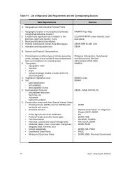
Table 2-1. List of Stakeholders Affected by the <strong>CLUP</strong><br />
Groups/Individuals<br />
A. Directly Affected<br />
Interests<br />
+ / - Effects<br />
B. Indirectly Affected<br />
1.6 Prepare an action plan for approaching and involving each person or group.<br />
Note:<br />
A decision has <strong>to</strong> be made regarding involvement of the stakeholders, and the extent of<br />
such involvement.<br />
Refer <strong>to</strong> Annex 2-1 for the guide in conducting consultations in the preparation of <strong>CLUP</strong>s.<br />
The community should be involved at the earliest planning stage <strong>to</strong> encourage ownership<br />
of the plan. Though general community participation is not always possible, extensive<br />
involvement may be facilitated through representation, focus group discussions, interviews,<br />
surveys, and other innovative forms of indirect participation.<br />
The action plan shall also include conflict resolution mechanisms <strong>to</strong> effectively solve<br />
any animosities or conflicts that may arise among the groups or individuals in public<br />
consultations. Problem solving processes and constructive handling of differing viewpoints<br />
should be part of skills training for consultation managers and facilita<strong>to</strong>rs.<br />
Knowing the participants beforehand could lead <strong>to</strong> a better consultation processes.<br />
1.7 Develop an Information and Education Campaign (IEC) plan <strong>to</strong> inform and<br />
solicit support and commitment of the identified stakeholders and the<br />
general public.<br />
The IEC plan shall include detailed information on the plan preparation and<br />
processes involved, conduct of consultation activities, and timelines for the<br />
whole planning process so that stakeholder participation is maximized.<br />
2. Implement the IEC Plan <strong>to</strong> ensure the early involvement of stakeholders in the<br />
planning process.<br />
FURTHER READING<br />
HLURB, (2000), Planning Strategically, Chapter 4., Diliman, Quezon City<br />
25<br />
Step 2. Identifying Stakeholders
Flow Chart for Identifying Stakeholders<br />
1<br />
Conduct workshops <strong>to</strong><br />
identify stakeholders<br />
affected by the <strong>CLUP</strong><br />
• Objectives informed<br />
• List of interest groups/individuals<br />
• Action Plan/strategies for approaching<br />
and involving stakeholders<br />
2<br />
Inform and solicit support and<br />
commitment of stakeholders<br />
Stakeholder support<br />
and commitment<br />
Step 2. Identifying Stakeholders 26
Annex 2-1<br />
GUIDE IN CONDUCTING CONSULTATIONS IN THE PREPARATION OF <strong>CLUP</strong>S<br />
WHAT<br />
(Stage)<br />
WHEN<br />
(Step)<br />
WHO<br />
<strong>to</strong> consult<br />
HOW<br />
<strong>to</strong> consult<br />
Getting started<br />
1<br />
Key decision<br />
makers<br />
Present proposal and generate commitment.<br />
Identifying stakeholders<br />
2<br />
Planning team/<br />
committees/TWGs<br />
Generate list of primary and secondary<br />
stakeholders.<br />
Planning<br />
• Gathering information/<br />
ideas <strong>to</strong> formulate/<br />
validate and establish:<br />
- the vision<br />
- the existing<br />
conditions<br />
- the objectives<br />
3<br />
4<br />
5<br />
All members of the<br />
community<br />
Identification of issues and ideas through<br />
broad-based discussions such as workshops,<br />
focus groups, surveys, meetings with existing<br />
groups, and interviews.<br />
• Analyzing data <strong>to</strong><br />
generate and evaluate<br />
options<br />
6<br />
Planning team and<br />
interested members<br />
of the community<br />
Explore the pros and cons of various options<br />
through participa<strong>to</strong>ry design workshops,<br />
evaluative workshops, and interactive<br />
displays/exhibits .<br />
• Developing a draft<br />
<strong>CLUP</strong><br />
7<br />
All members of the<br />
community<br />
Gather feedback <strong>to</strong> fine-tune the draft through<br />
presentations /displays, public hearings, workshops<br />
and submission of written comments.<br />
• Finalizing the plan<br />
7,8,9<br />
& 10<br />
All members of the<br />
community<br />
Inform the community of the final outcomes<br />
and decisions through use of tri-media, flyers,<br />
and various levels of public assemblies.<br />
Implementation<br />
11<br />
Concerned<br />
individuals/groups<br />
Consult concerned implementing offices/<br />
departments/individuals, affected areas,<br />
property owners, users, etc. depending on<br />
the specific nature of the program or project<br />
for implementation.<br />
Moni<strong>to</strong>ring and<br />
Evaluation<br />
12<br />
All members of the<br />
community<br />
Broad-based consultation regarding the<br />
overall success of the plan and targeted<br />
consultation <strong>to</strong> moni<strong>to</strong>r, review, and commence<br />
the revision of the <strong>CLUP</strong>.<br />
Note: For every step of the planning process, some forms of consultation will be required<br />
such as those involving the planning team, TWG, steering committees, and/or selected<br />
stakeholder groups/individuals. The purpose of these consultations range from preparing<br />
drafts, organizing reports/activities, sec<strong>to</strong>r analysis, review and finalization of<br />
documents, etc.<br />
27<br />
Step 2. Identifying Stakeholders
Comprehensive Land Use Planning<br />
SETTING<br />
THE VISION<br />
<strong>CLUP</strong><br />
STEP<br />
3<br />
Setting the Vision is a participative process whereby the municipality or city defines the<br />
future that it wants. The vision lays out what the citizens of the community would like<br />
their municipality/city <strong>to</strong> look like in terms of its physical, environmental, social and<br />
economic development.<br />
The visioning exercise binds the municipality/city <strong>to</strong>gether as a community which<br />
recognizes their shared values and purposes, and helps them articulate a shared vision<br />
of their locality. It creates a sense of ownership among the stakeholders <strong>to</strong> the extent<br />
that they want <strong>to</strong> achieve their vision as the plan gets implemented over the years. The<br />
vision serves as the driving force that moves the entire city/municipality <strong>to</strong>wards the<br />
achievement of a common development direction and provides the overall guidance<br />
and focus in the succeeding stages of the planning process.<br />
The VISION needs <strong>to</strong> be formulated in a participa<strong>to</strong>ry manner, and arrived at in a<br />
consensus. The formulation of the VISION may be done through the conduct of a<br />
visioning workshop participated in by the stakeholders.<br />
In setting the VISION, the following essential elements may be considered:<br />
• Qualities of the people as individuals<br />
• Qualities of the people as a society<br />
• Nature of the local economy<br />
• State of the natural environment<br />
• Capacity of local leadership<br />
The basic ingredients of a vision statement are:<br />
• Positive, present tense language<br />
• Qualities that provide the reader with a feeling for the municipality’s/<br />
city’s uniqueness<br />
• Depiction of the highest standards of excellence and achievement<br />
• A focus on people and quality of life<br />
• A stated time period<br />
PURPOSE<br />
• To formulate a widely acceptable vision statement for the municipality/city<br />
• To foster ownership of the vision statement<br />
Step 3. Setting the Vision 28
EXPECTED OUTPUTS<br />
• An overall vision statement for the municipality/city<br />
• Developed better communication among stakeholders<br />
• A basis for formulation of goals, objectives, programs and policies<br />
STEPS<br />
There are various methods of setting the vision for the city/municipality. These can be done<br />
through surveys, interviews, workshop, etc. The following workshop method may<br />
be used:<br />
FOR CITY/MUNICIPALITY SETTING A NEW VISION STATEMENT<br />
1. Conduct prepara<strong>to</strong>ry activities for the visioning workshop<br />
1.1 Identify participants/stakeholders <strong>to</strong> be involved in the visioning workshop<br />
session(s)<br />
At the minimum, participants shall include the members of the Local<br />
Development Council (LDC).<br />
1.2 Schedule the visioning workshop<br />
1.3 Announce and publicize the schedule of the visioning workshop/s and send out<br />
invitations well in advance for maximum participation. Avoid scheduling meetings<br />
that will conflict with holidays or other important community events.<br />
1.4 Prepare the workshop design using Technology of Participation (TOP)<br />
(Refer <strong>to</strong> Annex 3-1 for some techniques of participation)<br />
2. Conduct the visioning workshop according <strong>to</strong> the workshop design/program of activities.<br />
During the workshop:<br />
2.1 Discuss the objectives and mechanics of the visioning workshop<br />
2.2 Make a brief presentation on the importance of a vision in <strong>CLUP</strong> preparation and<br />
<strong>to</strong> the city/municipality<br />
2.3 Define and discuss the elements of a vision, specifically its relation <strong>to</strong> the planning<br />
process.<br />
2.4 Group the participants in<strong>to</strong> smaller workshop groups (ideally 6-8 persons per group).<br />
Use metacards during the workshop <strong>to</strong> encourage participation and <strong>to</strong> facilitate the<br />
generation and processing of data.<br />
29<br />
Step 3. Setting the Vision
2.5 Generate ideas on the perceived conditions of the city/municipality by posing the<br />
questions below:<br />
• What do you like about the municipality/city as it is now? (aspects you may<br />
wish <strong>to</strong> preserve)<br />
• What don’t you like about the municipality/city? (issues <strong>to</strong> be resolved/<br />
changed)<br />
• What do you think should be done <strong>to</strong> improve the municipality/city? (things<br />
you want <strong>to</strong> have/create in your municipality/city)<br />
The result of this activity will provide an approximate description of the current<br />
situation as a form of leveling-off for the participants’/community’s perception<br />
of their city/municipality.<br />
2.6 Generate ideas on the future/ desired state of the city/municipality by posing the<br />
question: What do you want your city/municipality <strong>to</strong> become 10-20 years from<br />
now? Use descrip<strong>to</strong>rs or adjectives <strong>to</strong> write ideas on metacards (one idea/descrip<strong>to</strong>r<br />
per metacards)<br />
2.7 Group the meta-cards/ideas according <strong>to</strong> the following essential elements of a<br />
vision:<br />
• Qualities of the people as individuals<br />
• Qualities of the people as society<br />
• Nature of the local economy<br />
• State of the natural environment<br />
• Condition of the built environment<br />
• Capacity of local leadership<br />
2.8 Summarize and validate in a plenary the relevant descrip<strong>to</strong>rs as shown below:<br />
ELEMENTS<br />
Natural Environment<br />
Local Economy<br />
People as Society<br />
People as Individuals<br />
Local Leadership<br />
Built Environment<br />
DESCRIPTORS<br />
(sample)<br />
Scenic, ecologically balanced, etc.<br />
Self-reliant, diversified, etc.<br />
Empowered, vigilant, etc.<br />
Disciplined, honest, law-abiding, etc.<br />
Transparent, responsible, firm, etc.<br />
Orderly, clean, vibrant, etc.<br />
2.9 Formulate at least two Vision Statements using the agreed descrip<strong>to</strong>rs generated<br />
in the previous step<br />
2.10 Evaluate, select, and reach consensus on the Vision Statement that best captures<br />
what the stakeholders want for their city/municipality<br />
Step 3. Setting the Vision 30
Evaluation of the vision may be guided by the following questions:<br />
• Does it capture the ideas/descriptions generated?<br />
• Is it easy <strong>to</strong> remember/memorize?<br />
• Is it inspiring, motivating and powerful?<br />
• Can it be felt or experienced?<br />
• Does it capture the aspirations of the community, and is it shared by all<br />
sec<strong>to</strong>rs of the community?<br />
• Is it attractive, ambitious and achievable?<br />
3. After the visioning workshop disseminate the selected Vision Statement <strong>to</strong> the<br />
Sangguniang Panglunsod/Bayan and the general public for feedback.<br />
4. Validate and refine the Vision Statement considering the feedback.<br />
5. Present the refined Vision Statement <strong>to</strong> the LDC for endorsement <strong>to</strong> the Sangguniang<br />
Panglunsod/Bayan for subsequent adoption.<br />
6. Conduct extensive information campaign on the adopted Vision Statement.<br />
The above visioning exercise was used in formulating the vision of Cagayan de<br />
Oro City, the result of which was adopted by the city. The said vision statement<br />
is quoted as follows:<br />
“A peaceful, orderly, livable city with a modern trading center<br />
where there are equal opportunities for our disciplined<br />
citizens <strong>to</strong> develop and prosper in a clean and healthy<br />
environment”.<br />
FOR CITY/MUNICIPALITY REVIEWING<br />
AN EXISTING VISION STATEMENT<br />
LGUs may revisit/revalidate their existing vision statement guided by the vision-reality<br />
gap analysis technique. This technique is best undertaken through a multi-stakeholder<br />
workshop after the situation analysis stage (Step 4) of the <strong>CLUP</strong> process.<br />
The workshop process will have the following steps:<br />
1. Discuss the objectives and mechanics of the visioning workshop.<br />
2. Present a brief situationer/current profile of the community.<br />
31<br />
Step 3. Setting the Vision
3. Define and discuss the elements of a vision, specifically its relation <strong>to</strong> the<br />
planning process.<br />
4. Group the participants in<strong>to</strong> smaller groups (ideally 6-8 persons per group).<br />
5. Complete the vision-reality gap matrix (refer <strong>to</strong> sample matrix on succeeding<br />
page) considering the result of the situation analysis.<br />
6. Fill in the matrix with the elements of the vision statement.<br />
7. Fill in the matrix with descrip<strong>to</strong>rs (desired quality) of the vision.<br />
8. Identify and agree on the success indica<strong>to</strong>rs for each descrip<strong>to</strong>r.<br />
9. Compare success indica<strong>to</strong>rs with current state of development (existing<br />
situation).<br />
10. Rate each indica<strong>to</strong>r according <strong>to</strong> its position in relation <strong>to</strong> achieving the vision.<br />
Use the following suggested rating scale.<br />
0 = Nothing at all has been achieved<br />
1 = Very little (1% <strong>to</strong> 25%) has been attained<br />
2 = Attainment is about 26% <strong>to</strong> 50%<br />
3 = Attainment is quite high (51% <strong>to</strong> 75%)<br />
4 = Vision is very close <strong>to</strong> being realized (76% <strong>to</strong> 100%)<br />
N = Inadequate information<br />
11. Identify vision-reality gap (result of deducting the rating from the highest possible<br />
score).<br />
12. Identify the planning concerns for action derived from descrip<strong>to</strong>rs with low achievement<br />
rating. These planning concerns will be essential when identifying initial policy options.<br />
13. Refine the vision statement as may be necessary based on the vision-reality gap<br />
analysis.<br />
IF THE VISION IS REFINED<br />
14. Present the refined vision statement <strong>to</strong> the LDC for endorsement <strong>to</strong> the SP/SB for<br />
subsequent adoption.<br />
15. Disseminate the adopted vision <strong>to</strong> the general public.<br />
Step 3. Setting the Vision 32
IF THERE IS NO REVISION,<br />
16. Proceed <strong>to</strong> the next step of the <strong>CLUP</strong> process<br />
EXAMPLES<br />
Vision-Reality Gap Matrix<br />
PEOPLE AS INDIVIDUALS (element)<br />
Descrip<strong>to</strong>r<br />
Success<br />
Indica<strong>to</strong>r<br />
Rating<br />
Policy Options<br />
God-loving<br />
Peace-loving<br />
Honest<br />
Reliable<br />
Caring<br />
Law abiding<br />
Child friendly<br />
3<br />
2<br />
3<br />
1<br />
2<br />
2<br />
• Conduct extensive value orientation<br />
courses<br />
• Strengthen moral recovery program<br />
• Set up a local knowledge center for<br />
children<br />
Healthy<br />
Long life<br />
expectancy<br />
Low morbidity rate<br />
Drug-free<br />
3<br />
2<br />
1<br />
• Introduce life prolonging programs<br />
• Provide medical support<br />
• Establish/maintain a drug<br />
rehabilitation center<br />
PEOPLE AS SOCIETY (element)<br />
Descrip<strong>to</strong>r<br />
Success<br />
Indica<strong>to</strong>r<br />
Rating<br />
Policy Options<br />
Empowered<br />
Public consultation<br />
made and integral part<br />
of the decision- making<br />
process<br />
POs/NGOs<br />
participate in<br />
planning,<br />
implementation,<br />
moni<strong>to</strong>ring and<br />
evaluation of LGU<br />
programs and projects<br />
1<br />
1<br />
• Encourage participation of civil society in<br />
public consultations<br />
• Institutionalize sec<strong>to</strong>ral committees<br />
• Involve POs/NGOs in the key stages of<br />
implementation of government programs and<br />
projects<br />
• Provide PO/NGO representation in all planning<br />
stages on continuing basis prolonging<br />
programs<br />
Vigilant<br />
Disaster prepared<br />
citizenry<br />
2<br />
• Strengthen City/Municipal/Brgy. Disaster<br />
Coordinating Council<br />
33<br />
Step 3. Setting the Vision
ENVIRONMENTAL MANAGEMENT (element)<br />
Descrip<strong>to</strong>r<br />
Success<br />
Indica<strong>to</strong>r<br />
Rating<br />
Policy Options<br />
Clean and Safe<br />
Quality at allowable<br />
water level set by<br />
Phil. National<br />
Drinking Water<br />
Standard<br />
N<br />
Moni<strong>to</strong>ring and testing of surface and<br />
ground water quality<br />
Attractive<br />
Density of greens<br />
within the urban core<br />
1<br />
Protection of old trees, regeneration<br />
sites, mangroves, and open green<br />
spaces<br />
Balanced<br />
Built-up area<br />
integrated with city’s<br />
open space network<br />
1<br />
Formulate a city open space plan and<br />
management guidelines<br />
LOCAL ECONOMY (element)<br />
Descrip<strong>to</strong>r<br />
Success<br />
Indica<strong>to</strong>r<br />
Rating<br />
Policy Options<br />
Diversified<br />
Increased no. of<br />
financial institutions<br />
4<br />
• Promote upgrading of quality<br />
education<br />
Increased no. of<br />
service<br />
establishments<br />
3<br />
• Encourage special health services<br />
<strong>to</strong> locate in Dagupan<br />
• Update and enact city ordinance <strong>to</strong><br />
accommodatethe informal sec<strong>to</strong>r<br />
Environment<br />
Friendly<br />
Maximum 10% of<br />
surface water for<br />
aquaculture<br />
0<br />
Regulate fishpens and enforce<br />
existing local fishing ordinance<br />
Step 3. Setting the Vision 34
LOCAL GOVERNANCE (element)<br />
Descrip<strong>to</strong>r<br />
Success<br />
Indica<strong>to</strong>r<br />
Rating<br />
Policy Options<br />
Firm<br />
Enforcement of local<br />
laws (e.g. zoning<br />
ordinance<br />
3<br />
• Strict imposition of penalties<br />
Low apprehended<br />
viola<strong>to</strong>rs, filed cases/<br />
imposed penalties,<br />
sanctioned viola<strong>to</strong>rs<br />
3<br />
Progressive<br />
(not only LGU<br />
administration<br />
but also<br />
governance)<br />
Less IRA dependent<br />
NGO/PO registered<br />
increase, NGO/PO<br />
active participation<br />
2<br />
2<br />
2<br />
• Intensify tax collection by efficient moni<strong>to</strong>ring<br />
and updating local ordinances on local taxes<br />
• Strengthen cash management<br />
• Improve internal audit system<br />
• Institutionalization of LGU-NGO-PO<br />
undertakings<br />
• Strengthening and federating SP-accredited<br />
NGOs/POs<br />
Examples of Vision Statements:<br />
1. Pasay City<br />
A scenic premiere city thriving with business and economic opportunities, guided by dynamic<br />
and efficient local leadership, and home <strong>to</strong> self-reliant, healthy, and morally upright people.<br />
2. Makati City<br />
A sustainable, highly developed, environmentally balanced and progressive urban center<br />
whose residents have a sense of well-being and are morally upright, educated, disciplined,<br />
self-reliant, and community oriented.<br />
3. San Fernando City<br />
A well planned and properly regulated land use and philosophy that the utilization of land resources<br />
should always gear <strong>to</strong>wards improving the quality of life, especially the poor and underprivileged<br />
and maintenance of ecological balance, over time, in the whole city.<br />
4. Tuguegarao City<br />
An improved quality of life that endures the optimum, balanced and sustainable development of<br />
the municipality as an administrative, institutional, cultural and balance center for the Cagayan<br />
Valley Region.<br />
5. City of Himamaylan, Negros Occidental<br />
A progressive, Ecologically-Balanced, Peaceful City characterized by a healthy, empowered<br />
and self-reliant citizenry under responsible, accountable governance with social justice and<br />
equality <strong>to</strong> all Himalaynon.<br />
35<br />
Step 3. Setting the Vision
Annex 3-1<br />
THE BASIC METHODS OF TECHNOLOGY OF PARTICIPATION (TOP)<br />
The basic methods of TOP as provided below have been successfully tested and applied in<br />
the planning process.<br />
1. Discussion method<br />
This is a method of facilitating group conversations and discussions which allows a group<br />
<strong>to</strong> deepen its insights and creativity on a common <strong>to</strong>pic or experience. It allows the members<br />
of the group <strong>to</strong> share the many and diverse perspectives in a non-confrontational manner.<br />
And it also reveals the bounds of consensus the group is willing <strong>to</strong> draw.<br />
2. Workshop method<br />
This method is a way of facilitating a group’s thinking about a particular <strong>to</strong>pic in<strong>to</strong> focused<br />
decisions and action. It is an effective way of building group consensus and moving it <strong>to</strong><br />
joint resolve and action.<br />
3. Action Planning Method<br />
This method, which combines both the discussion and workshop methods, is an effective<br />
structure for moving a group from a good idea <strong>to</strong> a concrete plan of action within specific<br />
time periods and with specifically outlined assignments and responsibilities.<br />
These methods may be applied <strong>to</strong> an infinite number of situations and purposes. Creatively<br />
combined and even adapted, these methods can serve as powerful <strong>to</strong>ols for both satisfying<br />
and empowering group experiences.<br />
TECHNOLOGIES OF PARTICIPATION<br />
Discussion<br />
Method<br />
Focused dialogue on a common <strong>to</strong>pic or<br />
experience<br />
Share diverse perspectives in a non-confrontational<br />
manner<br />
Deepen insights/resolve of a group<br />
Workshop<br />
Method<br />
Focus insights/discussions of a group (common<br />
ground)<br />
Build group consensus<br />
Move <strong>to</strong> joint action<br />
Action<br />
Planning<br />
Method<br />
Build concrete plan (assumes consensus exists)<br />
Create clear forms of accountability<br />
Initiate group action<br />
Reference: Materials given during the Refresher Course on Basic Group Facilitation and<br />
Conflict Resolution, Philippine Urban Forum, 6 June 2003, Innotech, Quezon City<br />
37<br />
Step 3. Setting the Vision
Comprehensive Land Use Planning<br />
ANALYZING<br />
THE SITUATION<br />
<strong>CLUP</strong><br />
STEP<br />
4<br />
Step 4 of the planning process, the Situation Analysis, basically answers the question:<br />
Where are we now? It is both analytical and diagnostic, geared <strong>to</strong>wards identifying<br />
issues, potentials and future development needs and spatial requirements of the city/<br />
municipality. Assessment involves technical and participa<strong>to</strong>ry methods.<br />
Technical assessment is based on factual data derived from surveys, official publications<br />
and records of the city/municipality, concerned national agencies and other entities.<br />
Assessment involves the use of indica<strong>to</strong>rs such as proportions, rates, frequency, quality/<br />
condition ( e.g. severity, critical, etc.), standards and other parameters that are vital in<br />
characterizing the situations.<br />
Participa<strong>to</strong>ry assessment is based on the outcome/results of barangay/community<br />
consultations, focus group discussions, meetings with key informants, multi-sec<strong>to</strong>ral<br />
meetings, etc. This activity facilitates the generation of the community’s felt needs,<br />
desires, and perceived issues and opportunities. Suggestions <strong>to</strong> address issues and<br />
concerns can also be derived from this exercise.<br />
Planning <strong>to</strong>ols such as SWOT, Problem Tree Analysis, Sieve Mapping Technique,<br />
Geographic Information Systems (GIS ), etc. are helpful <strong>to</strong>ols in situation analysis. The<br />
HLURB A <strong>Guide</strong> <strong>to</strong> Data Management in the <strong>CLUP</strong> <strong>Preparation</strong> provides the applications,<br />
layouts and examples of <strong>CLUP</strong> formulation using GIS as a <strong>to</strong>ol.<br />
PURPOSE<br />
• To identify/gather/update baseline data in order <strong>to</strong> assess the existing socioeconomic<br />
and physical and environmental characteristics of the LGU;<br />
• To identify the needs, issues and concerns <strong>to</strong> be addressed by the <strong>CLUP</strong> and the<br />
opportunities/potentials that can be tapped <strong>to</strong> achieve the community vision;<br />
• To identify Indigenous Knowledge Systems and Practices (IKSP)<br />
Step 4. Analyzing the Situation 38
EXPECTED OUTPUTS<br />
• Socio-economic, demographic, physical and environmental profile/data base of<br />
the city/municipality<br />
• Consolidated, prioritized major and significant development needs, issues,<br />
strengths and potentials of the LGU which have spatial components and are<br />
necessary in the achievement of the vision.<br />
• Existing land use map, thematic maps, and analytical maps of the entire area<br />
covered by the city/municipality, including the marine and coastal areas and<br />
freshwater wetlands such as rivers and lakes.<br />
STEPS<br />
The steps outlined below is focused on the assessment of the existing land uses in the city/<br />
municipality. The procedures for the social, economic and infrastructure sec<strong>to</strong>rs are discussed<br />
in Volume 2, Manual on Demography and Sec<strong>to</strong>ral Studies In Comprehensive Land Use<br />
Planning. All these studies may be done simultaneously.<br />
1. Conduct sec<strong>to</strong>ral studies of the planning area in parallel with the conduct of<br />
natural/physical/environmental, and land use assessment (step 2, below).<br />
This step involves updating of the existing demographic and socio-economic data and their<br />
subsequent analysis <strong>to</strong> come up with information that will characterize the current and<br />
past situations in the city/municipality.<br />
The sec<strong>to</strong>ral assessment may be guided by the <strong>Guide</strong> <strong>to</strong> Sec<strong>to</strong>ral Studies<br />
in the <strong>CLUP</strong> <strong>Preparation</strong> (Vol. 2) which covers the following:<br />
• Demography<br />
• Social<br />
• Economic<br />
• Infrastructure<br />
2. Conduct an assessment of the natural/physical/environmental features and<br />
existing land uses of the city/municipality following these steps:<br />
2.1 Collect data/map requirements as shown in Table 4 - 1.<br />
2.2 Prepare base map ( both presentation and report size maps ) of the whole planning<br />
area. Refer <strong>to</strong> Mapping <strong>Guide</strong>lines, Vol. VII of the HLURB <strong>Guide</strong>lines for the<br />
Formulation/Revision of Comprehensive Land Use Plan, 1996 or the HLURB: A<br />
<strong>Guide</strong> <strong>to</strong> Data Management in the <strong>CLUP</strong> <strong>Preparation</strong>.<br />
39<br />
Step 4. Analyzing the Situation
Tips for the preparation of base maps<br />
• The base map shall serve as the working map where the different land use<br />
categories of the whole municipality/city shall be delineated.<br />
• To facilitate a more accurate delineation of land uses, the working base<br />
map may be enlarged <strong>to</strong> cover certain districts (i.e. CBD, growth/urbanizing<br />
areas) and/or by clusters of barangays.<br />
• A <strong>to</strong>pographic map provides important physical information and reference<br />
points for the base map while a cadastral map gives a more accurate<br />
parcellary boundary information of the municipality/city.<br />
• Use the standard scales as suggested by the Inter-Agency Task Force on<br />
Geographic Information for uniformity and ease in overlaying techniques.<br />
Suggested scales are:<br />
1:5,000/1:10,000/1:25,000<br />
1:2,000/1:4,000 ( for enlarging specific areas in the LGU)<br />
• The use of GIS gives greater flexibility in preparing the base/working<br />
map in anydesired scale.<br />
• Road networks and surface drainage (water bodies) shall be properly<br />
delineated in order <strong>to</strong> facilitate the conduct of land use survey.<br />
• Coastal and marine areas should be reflected in the maps, showing the<br />
boundaries of the municipal water .<br />
Samples of base maps, existing land use and other thematic maps are presented<br />
in Annex 4- 2<br />
2.3 Conduct actual land use survey. Determine the existing land uses within the entire<br />
boundaries of the city/municipality including uses of its freshwater and marine water<br />
boundaries.<br />
Methods of land use survey:<br />
Foot survey<br />
Area inspection is done on foot (walking). This is recommended for high-density areas<br />
<strong>to</strong> produce precise survey checks, specifically for the urban areas or poblaciones.<br />
Windshield survey<br />
Windshield survey is done while riding a vehicle. It involves a rapid survey of land uses<br />
particularly in low density areas. It is used for a general land use survey of the entire<br />
municipality/city.<br />
The following technology will facilitate the determination and/or validation of actual land<br />
uses:<br />
• Global Positioning System (GPS)<br />
The use of handheld GPS receivers is the best way <strong>to</strong> perform actual<br />
ground survey and ground truthing.<br />
• Aerial pho<strong>to</strong>s and satellite imagery<br />
Available aerial pho<strong>to</strong>graphs and satellite imagery, combined with GIS<br />
technology, is used <strong>to</strong> derive and analyze land use data.<br />
The procedural steps in land use survey are presented in Annex 4-1; Annex 4-3<br />
presents the land use categories and the corresponding color coding.<br />
Step 4. Analyzing the Situation 40
Table 4-1. List of Maps and Data Requirements and the Corresponding Sources<br />
Data Requirements<br />
Sources<br />
A. Geographical, Administrative/Political Profile<br />
1. Geographic location of municipality Coordinates<br />
(longitudinal/latitudinal location)<br />
2. Location and significant role in relation <strong>to</strong> the<br />
province, region and country, if any.<br />
3. Municipal land area & boundaries<br />
4. Political Subdivisions (Urban-Rural Barangays)<br />
5. Alienable and disposable land<br />
NAMRIA/Topo Map<br />
LGU/PPFP/RPFP (other national, local<br />
area plans)<br />
DENR-FMB & LMB, LGU<br />
DENR<br />
B. Natural and Physical Characteristics<br />
1. Clima<strong>to</strong>logical conditions-type of climate-prevailing<br />
winds, average annual rainfall & mean temperaturetidal<br />
current patterns (for coastal areas)<br />
2. Topography<br />
• <strong>to</strong>pographic relief<br />
• elevation<br />
• slope<br />
• surface drainage (bodies of water within the<br />
city/municipality)<br />
3. Vegetation/Vegetative cover<br />
4. Soil<br />
- type/classification<br />
- soil suitability<br />
- land capability (if any)<br />
5. Hydrogeologic Features<br />
- groundwater resources<br />
- fault lines, etc.<br />
- volcanoes<br />
- bedrock foundation<br />
6. Conservation areas and other Special Interest Areas<br />
• Protected Areas (NIPAS and non-NIPAS) both<br />
terrestrial and marine<br />
• Ancestral domains<br />
• Prime Agricultural Lands (NPAAAD)<br />
• Primary Forests and other forest types<br />
• Fish Sanctuaries<br />
• His<strong>to</strong>rical, cultural and natural heritage sites<br />
• Wetlands (lakes, rivers, coral reefs, mangroves,<br />
seagrass beds, marshes, etc.)<br />
• Critical watersheds<br />
• Geothermal Sites/Plants<br />
• Mining and Quarrying Areas<br />
Philippine Atmospheric, Geophysical<br />
and Astronomical Services<br />
Administration(PAG-ASA)<br />
NAMRIA<br />
BSWM & LGU<br />
BSWM<br />
DENR – MGB, PHIVOLCS<br />
• DENR<br />
• National Commission on Indigenous<br />
People (NCIP), DENR<br />
• DA<br />
• DENR, FMB<br />
• DA-BFAR, PCMRD<br />
• NHI, NCCA, DENR<br />
• DENR, BFAR<br />
• DENR, NIA, PNOC<br />
• PNOC<br />
• DENR, MGB, Provincial Government<br />
41<br />
Step 4. Analyzing the Situation
Data Requirements<br />
Sources<br />
C. Land Use (Refer <strong>to</strong> Annex 4-3 on Land Use Categories)<br />
including the following Special Interest Areas:<br />
- Ancestral Domain<br />
- His<strong>to</strong>rical and cultural heritage areas<br />
- World heritage areas<br />
- Location of manmade structures e.g. dams,<br />
reservoirs, if any<br />
- Location/extent of mining/quarrying activities,<br />
such as sand, gravel, etc.<br />
- Previous land use maps ( 10-20 yrs. ago, if any )<br />
- Previous land use plan, if any<br />
Primary Survey<br />
National Commission on Indigenous<br />
People (NCIP)<br />
NHI/DOT/PTA/NCCA, LGU<br />
NHI, NCCA<br />
LGU<br />
LGU/DENR-MGB/Provincial Office<br />
LGU<br />
LGU<br />
D. Environmental Condition<br />
1. Location/distribution/condition of:<br />
- fish sanctuaries<br />
- coral reefs<br />
- mangroves<br />
- seagrass beds<br />
2. Classification of rivers/bodies of water within the<br />
municipality<br />
3. Quality of rivers, marine waters, etc. (polluted or not;<br />
degree of pollution)<br />
4. Probable sources of pollution, if any<br />
5. Geological/environmental hazard areas<br />
- fault zones<br />
- volcanoes<br />
- tsunami prone areas<br />
- areas susceptible <strong>to</strong> landslides, erosion,<br />
subsidence, sinkholes, etc.<br />
- areas prone <strong>to</strong> noise, air pollution<br />
- probable causes of hazards or risk<br />
DENR, Project Studies, surveys,<br />
interview with community<br />
DENR, Project studies, surveys,<br />
interviews<br />
- do –<br />
PHIVOLCS, DENR/MGB; interview with<br />
community; surveys, special studies, if<br />
any.<br />
E. Other Land Related Data:<br />
1. On-going and pipeline projects: type, location, area<br />
covered<br />
2. Policies covering Production, Protection, Infrastructure<br />
and Settlement areas as defined in the Provincial<br />
Physical Framework Plan (PPFP)<br />
NGAs (i.e. DPWH), LGU<br />
PPFP<br />
2.4 Conduct consultation workshops or interviews <strong>to</strong> gather perception of the community<br />
regarding the environmental condition of the city/municipality, including perceived<br />
causes/sources of degradation, if any, and the perceived impacts.<br />
Step 4. Analyzing the Situation 42
This activity may be done through barangay consultations and/or focus group<br />
discussion(s) with key stakeholders usually with the elderly in the community,<br />
who have good knowledge or have experienced natural calamities, disasters,<br />
or other environmental degradation that affected/is affecting the community.<br />
<strong>Guide</strong> questions shall be structured <strong>to</strong> cover the following:<br />
• Type/s of environmental degradation, calamity or disastrous events such<br />
as flashfloods, erosion, earthquakes, etc.<br />
• Extent of damage <strong>to</strong> lives, properties, and impact <strong>to</strong> the community<br />
• Frequency of occurrences<br />
• Perceived causes<br />
• Suggestions on how the community and the government can help mitigate<br />
such occurrences.<br />
Note: Some of these information may already be generated/gathered during the conduct<br />
of sec<strong>to</strong>ral studies<br />
3. Process and analyze data/information gathered.<br />
3.1 Plot/Delineate in the working base map all data/information on physical<br />
attributes of the city municipality for better appreciation of its spatial dimension.<br />
Sample thematic maps are presented in Annex 4-2.<br />
3.2 Prepare the existing land use map including water uses based on the information<br />
from the base map and the gathered land use data. The map shall<br />
include the following:<br />
- delineation of the various land uses (See color codes in Annex 4-3)<br />
- coastal and marine areas; boundaries of municipal waters<br />
- existing major wetlands, inland waters<br />
Note: Use maps which has the same size and scale as the base map.<br />
3.3 Quantify and determine the extent of distribution of each land use category<br />
and present in a tabular form and in any possible visuals or illustrations. A<br />
tabular presentation (see Table 4 - 2) is recommended <strong>to</strong> summarize the<br />
results of this step.<br />
3.4. Establish the relationship of each data with other relevant data.<br />
3.4.1 Examine/assess data relative <strong>to</strong> the geographical location and<br />
administrative/political domain of the city/municipality. Determine the<br />
situation of the city/municipality within the region/province in terms of<br />
area and its significant role, if, any.<br />
3.4.2 Analyze barangay distribution in terms of rural and urban areas;<br />
population size/concentration; economic activities and employment<br />
opportunities and accessibility <strong>to</strong> social services.<br />
43<br />
Step 4. Analyzing the Situation
3.4.3 Determine/analyze extent of alienable and inalienable lands within the<br />
city/municipality in terms of area, location, and barangays covered.<br />
3.4.4 Analyze impacts of existing land uses on the environment of the city/<br />
municipality, e.g. subdivision projects on sloping areas.<br />
3.4.5 Determine existing environmental condition and validate the perception<br />
of the community.<br />
Table 4-2. Existing Land Uses Area, Distribution, and Percent <strong>to</strong> Total<br />
LAND USE CATEGORIES<br />
• Urban Use Areas<br />
Residential<br />
Commercial<br />
Infrastructure/utilities<br />
Institutional<br />
Parks/playgrounds and other recreational spaces<br />
Industrial<br />
• Agriculture<br />
• Forest and forest use categories<br />
• Mining/quarrying<br />
• Grassland/pasture<br />
• Agro-industrial<br />
• Tourism<br />
• Other uses /categories<br />
• Cemeteries<br />
• Dumpsites/Sanitary Landfills<br />
• Buffer zones/greenbelts<br />
• Idle/vacant lands<br />
• Reclamations<br />
• Water uses<br />
• Nipa swamps<br />
• Mangrove forests<br />
• Tourism (recreation/resorts)<br />
• Settlements on stilts<br />
• Infrastructure (e.g. ports, fish landing)<br />
• Aquaculture and marine culture (e.g. fish cages/<br />
fish pens, seaweed culture, etc.)<br />
• Others, specify (e.g. river sand/gravel quarrying,<br />
coral reef, seagrass beds)<br />
* Definition of terms for coastal and marine areas are<br />
provided in Annex 4-4<br />
TOTAL<br />
AREA<br />
( in hectares )<br />
PERCENT TO<br />
TOTAL<br />
100%<br />
Step 4. Analyzing the Situation 44
4. Discuss the existing situation of the city/municipality in terms of the following:<br />
4.1 Geographical, Administrative and Political Domain<br />
• Geographic location, boundaries and land area<br />
• Political units (barangays: number, location, and area per barangay)<br />
4.2 Natural and Physical Characteristics<br />
• Topography and Slope (prevailing <strong>to</strong>pography and location, degree of slopes)<br />
• Climate (climate type, climatic conditions and prevailing winds)<br />
• Soil types and soil suitability (general soil types and suitability for agriculture,<br />
settlements, other uses)<br />
• Surface drainage (major water bodies, including coastal and marine,and<br />
freshwater lakes and rivers, marshlands, and other wetlands)<br />
• Hydrogeology (presence and extent of fault zones, types of bedrock<br />
formation, and location of surface and groundwater)<br />
• Mineral resources<br />
4.3 Existing Land Uses<br />
• Area per land use category and percentage <strong>to</strong> <strong>to</strong>tal land area (include table<br />
of these information).<br />
• Prevailing dominant land use and their location/distribution/intensity of use<br />
• Physical condition, adaptability for future use, and constraints <strong>to</strong> development<br />
(e.g. typhoons, fault lines, etc.)<br />
• Conflicting land uses and other land use problems and issues (e.g.<br />
settlements inside forest areas, flooding, blight, etc.)<br />
• Urban form and development trend (direction of physical/land use change<br />
and intensity of development)<br />
• Development potentials<br />
4.4 Existing Uses of Coastal and Marine Areas<br />
• Coastal and marine areas – describe significant features and natural<br />
attributes, length of coastline, and <strong>to</strong>tal boundary of marine municipal waters<br />
• Area and location of each utilization category<br />
• Present utilization – include other commercial activities such as resorts, or<br />
<strong>to</strong>urism sites, ports, fishing, quarrying activities, and aquaculture<br />
developments.<br />
• Location and extent of settlements, if applicable.<br />
• Point out specific problems, issues, particularly on conflicting uses within<br />
the coastal zone, resulting in environmental degradation and the like.<br />
4.5 Environmental Condition<br />
• Existing situation of coastal and marine areas - discuss manifested<br />
environmental stresses like beach erosion, marine pollution, damaged<br />
aquatic life, siltation or sedimentation<br />
• Freshwater bodies like lakes and rivers (quality and extent of water pollution,<br />
if any)<br />
45<br />
Step 4. Analyzing the Situation
• Risk areas/environmentally critical areas (nature, location, extent and<br />
frequency of occurrences)<br />
• Protected Areas (area covered, location, NIPAS category), forest areas,<br />
watersheds, and other natural resources<br />
• Land classification (location and area of forest/public lands and alienable<br />
and disposable lands)<br />
• Infrastructure facilities (focus on adequacy, capacity, condition, and loads<br />
for current and future population. A more detailed assessment is presented<br />
in the sec<strong>to</strong>ral manual on infrastructure, Vol 2).<br />
5. Establish the significant his<strong>to</strong>rical land use trends by describing the major<br />
land uses and general characteristics of such uses that prevailed in the<br />
city/municipality in previous plans or at certain points/eras in the past.<br />
5.1 Trace his<strong>to</strong>rical land use from as far back as existing records (documents,<br />
maps, pictures, etc.) and verified information are available;<br />
5.2 Presentation shall be in chronological order, from the earliest time <strong>to</strong> the<br />
present;<br />
5.3 Identify the major land use activities and their location<br />
5.4 Establish the his<strong>to</strong>rical land use trends by describing significant changes<br />
noted from one point <strong>to</strong> another.<br />
6. Prepare map <strong>to</strong> reflect areas that need <strong>to</strong> be conserved and preserved, and<br />
areas with physical constraints as follows:<br />
• Natural risks and hazards areas (volcanic, seismic, flood-prone, erosion-prone,<br />
tsunami-prone, etc.)<br />
• Protected areas such as National Integrated Protected Areas System (NIPAS),<br />
NON-NIPAS, Network of Protected Agricultural and Agri-Industrial Areas for<br />
Development (NPAAADs)<br />
• Wetlands/coastal, marine, lakes, rivers, marshes, man-made, etc.<br />
• His<strong>to</strong>rical and cultural areas (if any), Man and biosphere Areas (MAB) and other<br />
globally designated areas<br />
• Fish sanctuaries<br />
• Watersheds and forest areas<br />
• Existing land use<br />
Other Land Studies<br />
In addition <strong>to</strong> the land use survey, supplementary land studies may be undertaken<br />
<strong>to</strong> obtain additional information on the physical setting which may be needed in<br />
the formulation of the land use plan. These additional studies may or may not be<br />
carried out, depending on local circumstances, previous studies undertaken,<br />
available resources, etc. The discussions on Other Supplemental Land Studies<br />
in <strong>CLUP</strong> <strong>Preparation</strong> are presented in Annex 4-5.<br />
Step 4. Analyzing the Situation 46
7. Quantify the areas considered for conservation/preservation/protection and<br />
tabulate results.<br />
8. Determine the available land supply for development/future expansion areas:<br />
Land supply is the land area available within the city/municipality for urban use expansion.<br />
Basically, this is what is left after deducting the areas considered for protection/<br />
preservation and conservation such as the Network of Protected Agricultural and Agri-<br />
Industrial Development Areas (NPAAADs), National Integrated Protected Areas Systems<br />
(NIPAS), natural risks and hazards areas, and existing urban areas.<br />
Mathematically, this can be presented as follows:<br />
Land Supply for development/future development areas =<br />
TLA – (PCA+UA+SLU)<br />
Where: TLA = Total Land Area of the city/municipality<br />
PCA = Protection/Preservation and Conservation Areas<br />
(Refer <strong>to</strong> identified development constraints and<br />
quantified areas)<br />
UA = Urban Use Areas are the built-up areas or those areas<br />
with urban activities/land uses.<br />
SLU = Special Land Uses that are significant and unique <strong>to</strong><br />
the city/municipality, e.g. agro-industrial, <strong>to</strong>urism<br />
areas designated for projects in the pipeline (Refer<br />
<strong>to</strong> Table 1, Existing Land Uses)<br />
Sample Computations:<br />
Given Parameters (Figures are hypothetical) Areas (in Has.)<br />
Total Land Area 50,000<br />
Preservation and Conservation Areas (PCA) 25,000<br />
Urban Use Areas (UA) 10,000<br />
Special Land Uses (SLU) 5,000<br />
Land Supply for Development/<br />
Future Expansion Areas = 50,000 – (25,000+10,000+5,000)<br />
= 10,000<br />
9. Estimate the <strong>to</strong>tal land area required or needed for urban development and<br />
other special planning areas. This may be the <strong>to</strong>tal land requirements<br />
determined in the sec<strong>to</strong>ral studies or derived through various methods as<br />
follows:<br />
• Use of various national agency standards<br />
Land for future expansion of urban and other uses is projected on the basis of the<br />
given standard area/space requirement per sec<strong>to</strong>r multiplied by the population<br />
growth index.<br />
47<br />
Step 4. Analyzing the Situation
(A more detailed procedure on the computation of space requirements per sec<strong>to</strong>r<br />
are presented in the sec<strong>to</strong>ral studies manual, Vol. 2)<br />
Future space requirement = space standard x growth index<br />
Where the growth index is an appropriate fac<strong>to</strong>r <strong>to</strong> which standards are applied;<br />
specifically, it refers <strong>to</strong> forecast levels of housing s<strong>to</strong>cks, employment, production<br />
and facility requirements.<br />
This simple formula is not applicable <strong>to</strong> all types of land use activities. Space<br />
requirements for some uses such as government or civic centers, art centers,<br />
museums, and open space systems (greenbelts, land reserves) are best<br />
determined by special studies and on a case <strong>to</strong> case basis. Also, initial<br />
computations using space standards are usually adjusted <strong>to</strong> include allowances<br />
for flexibility (say 20% addition <strong>to</strong> the computed area requirement) and <strong>to</strong> conform<br />
<strong>to</strong> availability of appropriate locations and desired density/intensity.<br />
The LGU may however, opt <strong>to</strong> agree on parameters for determining space<br />
requirements unique <strong>to</strong> their local situation and consistent with the adopted vision.<br />
• Current urban density – this approach assumes that future land allocation for<br />
urban use shall be based on existing urban density regardless of the growth in<br />
urban population.<br />
The future land requirement is derived by multiplying the current urban density<br />
by the projected population. The derived sum will be redistributed according <strong>to</strong><br />
the existing share of each land use category <strong>to</strong> the <strong>to</strong>tal urban land requirement.<br />
• Other methods or standards as may be agreed upon by the planning team.<br />
The estimated land requirements shall be properly justified in terms of the method<br />
used, and the vision and functional role of the city/municipality.<br />
The land requirements may also increase or decrease, as needed, during the<br />
final stages of the plan formulation.<br />
10. Conduct a cross-sec<strong>to</strong>ral analysis and integration of the results of the<br />
demographic and the socio-economic and environmental studies <strong>to</strong> derive<br />
the most pressing and significant problems and issues.<br />
This activity requires a series of consultative workshops with key stakeholders <strong>to</strong><br />
be conducted by the planning team.<br />
Step 4. Analyzing the Situation 48
This step should result <strong>to</strong> the identification of the following:<br />
• Internal strength of the city/municipality in terms of:<br />
- Natural/physical features<br />
- Socio-economic and manpower resources<br />
- Administrative/institutional and financial capacities<br />
- Other internal resources/capacities<br />
• Opportunities<br />
- Development role assigned by higher-level plans<br />
- On-going or pipeline investment plans, development projects of the national<br />
government and/or private inves<strong>to</strong>rs<br />
- Developments in the region, province, offering opportunities for tapping the LGUs<br />
resources<br />
- Other internal national, regional, or local circumstances/events offering<br />
opportunities for the LGU.<br />
• Weaknesses, such as:<br />
- Poor soil quality;<br />
- Lack or shortage of infrastructural support facilities such as irrigation, road,<br />
power, water and telecommunication;<br />
- Lack of market;<br />
- Credit facilities, health, recreational and educational facilities;<br />
- Lack of skilled labor force;<br />
- Located in a typhoon prone area or along geologic fault lines;<br />
- Presence of erosion prone areas;<br />
- Adherence <strong>to</strong> traditional values and farming practices;<br />
- Low literacy rates;<br />
- Lack of response <strong>to</strong> incentives;<br />
- Unresponsive government machinery and deteriorated peace and order<br />
condition;<br />
• Threats<br />
- Environmental degradation (include air/water/soil pollution) from existing or<br />
proposed manufacturing/processing facilities;<br />
- Ecological changes (water/moisture supply) brought about by extent of<br />
degradation of mangrove and swamps;<br />
- Extent of damage <strong>to</strong> flora and fauna;<br />
- Irreversible land degradation from existing mining explorations or mineral<br />
exploitation;<br />
- Pollution of river systems from solid wastes; siltation due <strong>to</strong> erosion from<br />
denuded forests;<br />
- Depletion of coral reefs/fish sanctuaries;<br />
- Destruction of aesthetics;<br />
- His<strong>to</strong>rical and human interest features in the province and change in government<br />
policies or leadership;<br />
The procedural steps for the conduct of SWOT and Cross-Sec<strong>to</strong>ral analysis<br />
techniques are presented in Annexes 4-6 and 4-7, respectively.<br />
49<br />
Step 4. Analyzing the Situation
Flow Chart for Situation Analysis<br />
STEPS<br />
OUTPUTS<br />
Demographic/Socio-<br />
Economic/Infrastructure-<br />
Utilities Profile<br />
Conduct<br />
sec<strong>to</strong>ral studies<br />
Sec<strong>to</strong>ral<br />
needs/issues/problems<br />
Projected/future<br />
sec<strong>to</strong>ral land requirements<br />
Conduct<br />
assessment of<br />
natural/physical/<br />
environmental<br />
features<br />
Physical Environmental<br />
Profile<br />
Existing Land Uses:<br />
• Categories and Areas<br />
• Existing Land Use Map<br />
• Thematic and Analysis Maps<br />
3<br />
Conduct cross-sec<strong>to</strong>ral<br />
analysis and integration of<br />
sec<strong>to</strong>rs and land uses<br />
• Development Constraint/<br />
Non-buildable areas<br />
• Total future land requirements<br />
• Potential development areas<br />
• LGU potentials and<br />
comparative advantages<br />
• Priority issues and problems<br />
• Possible intervention<br />
51<br />
Step 4. Analyzing the Situation
Step 1. Determine pace fac<strong>to</strong>r.<br />
Annex 4-1<br />
STEPS IN LAND USE SURVEY<br />
Foot survey<br />
Pace fac<strong>to</strong>r is applied <strong>to</strong> calculate frontage distance for each structure in the block/zone being<br />
surveyed.<br />
A block is a portion of land usually bounded by streets. It can accommodate a number of<br />
structures used for different purposes.<br />
The pace fac<strong>to</strong>r is computed as follows:<br />
√<br />
√<br />
√<br />
√<br />
√<br />
Get a 50-meter tape measure. Spread tape.<br />
Let the fieldworker walk at least three times along the tape. Record the number<br />
of the paces in every direction.<br />
Add number of paces and divide by the number of times the fieldworkers<br />
walked along the tape.<br />
Divide 50 meters by the average number of paces. The result is the pace<br />
fac<strong>to</strong>r.<br />
To get the frontage distance, simply multiply the number of recorded paces by<br />
the pace fac<strong>to</strong>r.<br />
Step 2. Note down the exact use of land areas and structures on them. The information<br />
should be recorded on the survey sheet and plotted on the working map.<br />
Windshield Survey<br />
Step 1.<br />
Step 2.<br />
Step 3.<br />
Set odometer reading <strong>to</strong> zero. A working map and <strong>to</strong>pographic map/aerial pho<strong>to</strong> must<br />
be on hand <strong>to</strong> record land uses and <strong>to</strong> note changes, if any.<br />
Use a compass <strong>to</strong> ensure correct orientation on the working map. A pair of binoculars<br />
would also be useful in conducting the ocular survey.<br />
Note changes in land uses leading for instance, in area expansion.<br />
With the use of reference points like rivers, roads and other land marks, boundaries<br />
of specific uses maybe approximated on the <strong>to</strong>pographic map/material pho<strong>to</strong>graph.<br />
The odometer must be read <strong>to</strong> determine the approximate distance where the changes<br />
occur along the highway. Boundaries may also be counterchecked with recent aerial<br />
pho<strong>to</strong>graphs.<br />
Step 4.<br />
Transfer the survey findings on the base map. Use appropriate color in the delineation<br />
of the land use categories (Refer <strong>to</strong> Table4-1 for standard color code per land use<br />
category)<br />
Global Positioning System (GPS) Survey<br />
Step 1. Familiarize yourself with the GPS receiver being used.<br />
Read and follow the manufacturer’s instruction on the use and operation of the<br />
Step 4. Analyzing the Situation 52
GPS receiver. Make sure that all settings are correct and appropriate and that satellite<br />
and weather conditions for GPS reading are satisfied before conducting the survey.<br />
Step 2.<br />
Step 3.<br />
Proceed <strong>to</strong> the points of observation and get the GPS reading, record these readings<br />
(usually the latitude and longitude) and a description of the points being occupied.<br />
Transfer readings on a base map by either manual plotting or by uploading the data<br />
from the GPS <strong>to</strong> a computer. Software is available which can get and process data<br />
from GPS receivers.<br />
GPS survey can also be used <strong>to</strong> verify data on a GIS system. Method of data gathering is the<br />
same as the steps above and once the information is uploaded in a computer, most GIS<br />
applications can read GPS data and can be processed using these applications. Furthermore,<br />
some GPS receivers can be uploaded with the points <strong>to</strong> be verified and others can s<strong>to</strong>re digital<br />
maps so validation of boundaries can be done in the field.<br />
Refer <strong>to</strong> Volume 3, A <strong>Guide</strong> <strong>to</strong> Data Management in <strong>CLUP</strong> <strong>Preparation</strong> for a<br />
comprehensive discussion on land use related survey and mapping.<br />
53<br />
Step 4. Analyzing the Situation
Annex 4-2<br />
SAMPLE MAPS<br />
Note: Refer <strong>to</strong> GIS Cookbook (Vol. 3) for updated GIS maps.<br />
Step 4. Analyzing the Situation 54
Note: Refer <strong>to</strong> GIS Cookbook (Vol. 3) for updated GIS maps.<br />
55<br />
Step 4. Analyzing the Situation
Annex 4-3<br />
LAND USE CATEGORIES AND COLOR CODING<br />
LAND USE CATEGORIES<br />
COLOR CODING<br />
• Urban Use Areas<br />
Residential<br />
Commercial<br />
Infrastructure/utilities<br />
Institutional<br />
Parks/playgrounds and other recreational<br />
spaces<br />
Industrial<br />
• Agriculture<br />
• Forest and forest use categories<br />
• Mining/quarrying<br />
• Grassland/pasture<br />
• Agro-industrial<br />
• Tourism<br />
• Other uses /categories<br />
• Cemeteries<br />
• Dumpsites/Sanitary Landfills<br />
• Buffer zones/greenbelts<br />
• Idle/vacant lands<br />
• Reclamations<br />
• Water uses<br />
• Nipa swamps<br />
• Mangrove forest<br />
• Tourism (recreation/resorts)<br />
• Settlement on stilts<br />
• Aquaculture and mariculture (e.g. fish<br />
cages/fishpens, seaweed culture)<br />
• Others, specify (e.g. river sand/gravel<br />
quarrying, coral reef, seagrass beds)<br />
* Definition of terms for coastal and marine areas are<br />
provided in Annex 4-4.<br />
Step 4. Analyzing the Situation 56
Annex 4-4<br />
DEFINITION OF TERMS FOR COASTAL AND MARINE AREAS<br />
1. Brackishwater Fishponds (earthponds) - man-made enclosures of varying size,<br />
dependent on tidal fluctuations of water management, located in estuaries (deltas, mudflats<br />
and mangrove swamps) and intended for the culture of fishes/aquatic species.<br />
2. Brackishwater Swamps - land areas where most of the time the brackishwater level is at/<br />
above the land surface.<br />
3. Coastline - lines that form the boundary between the land and water, especially of sea or<br />
ocean.<br />
4. Coral reefs - simply defined, these are reefs made chiefly of fragments of corals, coral<br />
sands, algae and other organic deposits, and the solid limes<strong>to</strong>ne resulting from their<br />
consolidation. Technically, they are marine shelves or platforms formed by the consolidation<br />
of the skele<strong>to</strong>n of hermatypic corals through cementation by coralline algae and lithification<br />
processes.<br />
5. Dunes - an accumulation of sand in ridges or mounds landward of the beach formed by<br />
natural processes and usually parallel <strong>to</strong> the shoreline.<br />
6. Estuary - a water body where sea water of oceanic origin is diluted by freshwater from<br />
land drainage areas. Areas influenced by this include deltas, tidal marshes, and river mouth,<br />
among others.<br />
7. Foreshore area - as defined, it is a strip of land alternately covered and uncovered by the<br />
tidal movements. Its interior limits are that portion of land reached by the water during the<br />
highest equinoctial tide. The outer limit is that portion of land reached by the water during<br />
the lowest ordinary tide.<br />
8. Freshwater bodies - these are water bodies in basins, rivers, lakes, lagoons, channels<br />
and aquifers not influenced by sea water.<br />
9. Freshwater swamps - these are land areas where the freshwater table is at or above the<br />
land surface during most of the year <strong>to</strong> promote the formation of hydric soil and <strong>to</strong> support<br />
growth of hydrophytes such as grasses and sedges which are also influenced by sea<br />
water.<br />
10. Mangroves or mangrove forests - the communities of trees and associated shrubs that<br />
are restricted <strong>to</strong> tidal flats in coastal waters, extending inland along rivers where the water<br />
is tidal, saline or brackish.<br />
11. Marine waters - these cover beds, banks, shell fields, zones, areas and regions of Philippine<br />
waters <strong>to</strong>taling some 1,666,300 sq. km.<br />
12. Mineralized areas - areas containing deposits of metallic and non-metallic minerals.<br />
13. Municipal waters - “include not only streams, lakes and tidal waters Included within the<br />
municipality, not being the subject of private ownership, and not comprised within national<br />
parks, public forests, timber lands, forest reserves, but also marine waters included between<br />
two lines drawn perpendicularly <strong>to</strong> the general coastline from points where the boundary<br />
57<br />
Step 4. Analyzing the Situation
lines of the municipality or city <strong>to</strong>uch the sea at low tide and a third line parallel with the<br />
general coastline and fifteen (15) kilometers from it. Where two (2) municipalities are so<br />
situated on the opposite shores that there is less than 15 kilometers of marine waters<br />
between them, the third line shall be equally distant from the opposite shores of the respective<br />
municipalities.” (Section 131, Republic Act No. 7160)<br />
14. Seagrass beds - vegetation dominated by flowering grasses which grow best in sandymuddy<br />
portions of the intertidal zone. They are highly productive habitats which serve as<br />
the transition zone between coral reefs and mangroves.<br />
15. Tidal flats - these are lands mostly devoid of trees and shrubs that are alternatively exposed<br />
and inundated by tides. These may be mud flats or sand flats (see foreshore areas).<br />
16. Woodlands - these occur behind the beach and dune on the older beach areas. In the<br />
coastal zone, these consist essentially of a tangle of low stunted trees or shrubs. Examples<br />
are bo<strong>to</strong>ng, pandan, and the taller agoho and coconut palms.<br />
Source: DENR<br />
Step 4. Analyzing the Situation 58
ANNEX 4-5: OTHER SUPPLEMENTAL LAND STUDIES IN <strong>CLUP</strong> FORMULATION<br />
1. Vacant lands study<br />
Vacant lands are classified according <strong>to</strong> <strong>to</strong>pographic and drainage characteristics and<br />
availability of improvements near such vacant lands. Vacant lands may be classified as<br />
prime lands, 0-15% in slope, and are in close proximity <strong>to</strong> water, sewer and other utility<br />
lines. Such vacant lands are suitable for industrial, commercial, residential, and other urban<br />
uses.<br />
Marginal lands are lands subject <strong>to</strong> flooding, over 15% in slope, or other lands unsuitable or<br />
uneconomic <strong>to</strong> develop.<br />
Availability of prime vacant lands for development will depend on such fac<strong>to</strong>rs as willingness<br />
of owners <strong>to</strong> release the property, existence of clear titles, and absence of other<br />
encumbrances on the land.<br />
Data on vacant lands can be presented both with the use of maps and statistical tables.<br />
For map presentation, prime and marginal vacant lands should be distinguished by an<br />
appropriate legend.<br />
Compute and tabulate areas of vacant lands from the map, using dot grid or planimeter<br />
according <strong>to</strong> previously suggested table formats. The resulting figures can then be compared<br />
with identified needs for new development areas.<br />
Land use planning application<br />
The main purpose of this study (which is usually included in the land use survey) is <strong>to</strong><br />
classify vacant lands within the planning area as <strong>to</strong> suitability for development.<br />
2. Flooding areas study<br />
This particular study forms the basis for two general types of proposals:<br />
a. Proposals for flood control works which aim <strong>to</strong> keep water away from man; and<br />
b. Proposals for control of flood plain development through planning and regula<strong>to</strong>ry efforts<br />
which aim <strong>to</strong> keep man away from the water.<br />
In some cases, delineating general floodway areas based on past flood records may be<br />
sufficient for purposes of this type of study. But in more urbanized areas and where flooding<br />
is a significant or potential problem, flooding studies should be carried out in more detail<br />
and complexity. This would require the services of an engineer, or better, a hydrologist.<br />
Three types of flood levels are established in the more complex flooding studies 1 . These<br />
are:<br />
a. “Highest flood of record” – areas along river or stream inundated by highest known<br />
flood for which records are available;<br />
1<br />
Stuart F. Chapin, Jr., Urban Land Use Planning, University of Illinois Press, 1965, p. 307.<br />
59<br />
Step 4. Analyzing the Situation
. “Standard project flood” – potential flood areas based on coincidental of the most critical<br />
conditions noted in meteorological and flood data from a wide surrounding area; this<br />
approximates highest flood of record for the regional area;<br />
c. “maximum probable flood” – maximum flood of reasonable regional expectancy taking<br />
in<strong>to</strong> account present knowledge; this flood is the most extensive of the three.<br />
Ideally, local planners should seek <strong>to</strong> provide for protection from the maximum probable<br />
flood. This would, however, entail staggering costs in terms of flood control works and the<br />
withdrawal of more land from development. It may instead be more realistic <strong>to</strong> plan for the<br />
eventuality of a standard project flood. In practice, local planners may, in the absence of<br />
funds, initially establish floodway lines for the first two flood levels and phase proposed<br />
flood control works in stages.<br />
In addition <strong>to</strong> establishing flood levels, basic hydrological studies usually include<br />
investigations of flood profiles (maps and cross-section diagrams of flood levels), period of<br />
inundation, rate of rise, velocity of flood waters, frequency of flooding, obstructions that<br />
affect crest levels, and land use encroachments on the flood plain.<br />
Land use planning application<br />
Identified flooding areas, or those areas covered by floodway lines drawn on a map, are<br />
designated as ‘limited use’ areas which can be earmarked only for open space uses or for<br />
the least intensive uses (e.g. parks, etc.); areas in flood plains which are already developed<br />
can be earmarked for remedial action, such as relocation or flood control works.<br />
3. Structural and environmental quality survey<br />
The study of the quality of the urban environment and of man-made structures (residential,<br />
commercial, industrial, institutional) is aimed at identifying the so-called urban renewal<br />
area. Urban renewal actions are of two types:<br />
1. Rehabilitation – the improvement or res<strong>to</strong>ration of identified blighted areas; and<br />
2. Redevelopment – clearance and rebuilding of areas which are in more advanced<br />
stages of blight.<br />
Conditions of blight are categorized in<strong>to</strong> two types – simple and complex forms of blight.<br />
Physical indica<strong>to</strong>rs of simple blight include such conditions as structural deterioration,<br />
missing sanitation facilities, structures in disrepair or lacking in elemental maintenance,<br />
presence of trash and rubbish accumulations, adverse, environmental influences such as<br />
noise, odors, dust, etc., and missing community facilities such as schools, playgrounds,<br />
public water and sewerage system, and adequate street and drainage facilities. Social<br />
indica<strong>to</strong>rs may also be considered, such as abnormally high rates of juvenile delinquency,<br />
and low health and welfare indices. Economic indica<strong>to</strong>rs include concentration of tax<br />
delinquents and untaxed titled properties, declining property values, and large number of<br />
building vacancies.<br />
The presence of simple forms of blight usually call only for rehabilitation measures. These<br />
may involve such actions as spot condemnation of structures, building repairs, or provision<br />
of missing sanitary facilities through sanitation code enforcement, a public improvement<br />
program for the provision of missing community facilities and a campaign for voluntary<br />
clean-up, painting and improved building maintenance standards. The presence of <strong>to</strong>o<br />
Step 4. Analyzing the Situation 60
many forms of simple blight may, however, call for the more drastic measures of clearance<br />
and redevelopment.<br />
The presence of complex forms of blight call for redevelopment measures. Indica<strong>to</strong>rs of<br />
this type of blight include such characteristics as mixture of incompatible land uses (such<br />
as the presence of pollutive industries right in the middle of residential areas), obsolete or<br />
impractical layout of lots, blocks, and streets, unsafe and unhealthful conditions existing or<br />
possible when marginal land is in use, particularly lands subject <strong>to</strong> floods, marshiness or<br />
tidal flow.<br />
Survey techniques<br />
Information on structural conditions, particularly of residential structures, may be available<br />
from secondary sources like the NSO census on housing. More often than not, however,<br />
data on structural and environmental quality have <strong>to</strong> be gathered first-hand. When such is<br />
the case, survey techniques have <strong>to</strong> be devised. The types of parameters and structural<br />
and environmental quality standards which will apply in categorizing urban renewal areas<br />
will depend on a host of fac<strong>to</strong>rs such as local environmental policies, public sentiment, and<br />
availability of funds <strong>to</strong> carry out renewal programs.<br />
In any case, the schedule <strong>to</strong> be used in the survey should include both dwelling units appraisal<br />
fac<strong>to</strong>rs. Dwelling appraisals may include maintenance and state of repair, safety and<br />
sanitation fac<strong>to</strong>rs, adequacy of lighting, degree of room crowding, etc. Environmental quality<br />
may be appraised on the basis of land crowing, inimical land uses on the block, inadequacy<br />
of schools, recreation areas, and other community facilities in the area, and the extent of<br />
hazards and nuisance in the area from traffic, railroads and industry.<br />
For land use planning purposes, a low-ratio sampling survey (i.e. using relatively only a<br />
small portion of the blocks or districts as sample) of urban areas would be sufficient. Based<br />
on the items in the survey schedule, urban areas can be categorized in<strong>to</strong>: 1) Areas in good<br />
or acceptable condition; 2) Rehabilitation areas; or 3) Clearance and development areas.<br />
Land use planning application<br />
Data on urban renewal areas, presented both in map and statistical forms, will show the<br />
rehabilitation and redevelopment areas <strong>to</strong> be considered in the preparation of more detailed<br />
urban renewal plans.<br />
4. Land values study<br />
The land values goes in<strong>to</strong> an investigation of the structure of land values, upward or<br />
downward graduations and trends of change in these values. Actual market values are<br />
arrived at only by extensive and costly studies which may not be practicable in most<br />
situations. Land values of urban lots or rural lots, which are usually available at the municipal/<br />
city Assessor’s Office. Assessed value figures may be refined based on comparison with<br />
known selling prices and the approximate percentage deviation of assessed value from<br />
market values.<br />
Land use planning application<br />
With the use of map showing approximate land values in the planning area, proposed<br />
locations for projects can be evaluated for feasibility in terms of land costs, especially<br />
61<br />
Step 4. Analyzing the Situation
where private investment is envisioned such as for housing or commercial development.<br />
5. Studies of aesthetic features of the planning area<br />
Land use planning is also concerned with the preservation and development of certain<br />
natural and man-made features of the planning area in a manner calculated <strong>to</strong> enhance<br />
these qualities for the enjoyment of residents, as well as visi<strong>to</strong>rs <strong>to</strong> the locality. Studies of<br />
aesthetic are most directly related <strong>to</strong> the amenity considerations involved in land use<br />
planning.<br />
Aesthetic features are determined on the basis of perceptual considerations – as these<br />
are observed in such terms as beauty, pleasantness, sense of spaciousness, and his<strong>to</strong>rical<br />
value. Since these considerations are largely subjective in nature, it is important <strong>to</strong> establish<br />
some acceptable and valid criteria for determining which features of the locality are <strong>to</strong> be<br />
reserved for aesthetic considerations.<br />
There is yet no method devised by which aesthetic features can be studied on a wholly<br />
objective manner. Criteria used will largely depend on local policies and the values of<br />
those concerned – local officials, planners, and the citizens alike.<br />
As <strong>to</strong> what <strong>to</strong> look for in conducting aesthetic studies, local planners may be guided by the<br />
following:<br />
5.1 Identify three-dimensional characteristics of the city’s/municipality’s site and the<br />
man-made features which have been added <strong>to</strong> the site.<br />
a. Six basic ground forms of city/municipal sites<br />
1. level or gently sloping or rolling<br />
2. sloping sites, backed by hills, or steeper slopes<br />
3. valley or gorge sites<br />
4. ampitheatrical or fan-shaped<br />
5. bowl-shaped<br />
6. ridged or hill<strong>to</strong>p<br />
b. Forms of man-made features<br />
1. urban textures<br />
2. green areas<br />
3. circulation facilities<br />
4. paved open spaces<br />
5. individually significant architectural masses<br />
5.2 Record significant paths and vantage points from which the city/municipality can<br />
usually be perceived.<br />
1. the panorama – sweeping view of sections of the city/municipality<br />
2. the skyline – applicable in areas with conglomeration of tall structures<br />
3. the vista – view seen from an opening, such as a street or a boulevard<br />
4. the urban open space<br />
5. through the experience of the individual in motion.<br />
Step 4. Analyzing the Situation 62
Land use planning application<br />
From the reconnaissance surveys of the city/municipality’s sites, natural and man-made<br />
features which should be visually accented or utilized and enhanced for aesthetic reasons<br />
can be spotted and outlined on a base map. A sketchbook or pho<strong>to</strong> album record of such<br />
features may also be used.<br />
FURTHER READING<br />
Stuart F. Chapin, Jr., Urban Land Use Planning, University of Illinois Press, 1965.<br />
63<br />
Step 4. Analyzing the Situation
Annex 4-6<br />
SWOT ANALYSIS TECHNIQUE<br />
SWOT Analysis is a method that enables a planner <strong>to</strong> generate feasible alternative strategies<br />
for the LGU through an assessment of the present conditions, characteristics, and current<br />
state and utilization of the LGU’s natural/physical, human and fiscal resources.<br />
• Serves as basis for evaluating where the LGU’s strength lies. Thus, serves<br />
as guide in determining which aspects <strong>to</strong> pursue and what weaknesses<br />
and threats <strong>to</strong> overcome <strong>to</strong> take advantage of opportunities.<br />
• Internal strengths can be used <strong>to</strong> take advantage of external opportunities<br />
or <strong>to</strong> overcome external threats.<br />
• The planners can formulate and pursue defensive-type strategies aimed at<br />
overcoming weaknesses and avoiding external threats.<br />
• The planners can formulate and pursue strategies that will improve on the<br />
LGU’s internal weaknesses by taking advantage of external opportunities.<br />
The SWOT Matrix is an important strategy-formulation matching <strong>to</strong>ol that results in the<br />
development of four types of strategies: Strengths-Opportunities (SO) strategies,<br />
Weaknesses-Opportunities (WO) Strategies, Strengths-Threats (ST) strategies and<br />
Weaknesses-Threats (WT) strategies.<br />
HOW IS SWOT ANALYSIS DONE?<br />
SWOT Analysis is done through a workshop with the participation of the local<br />
officials and the various representatives of the different sec<strong>to</strong>rs of the LGU and<br />
key stakeholders<br />
Step 1.<br />
Step 2.<br />
Divide the participants in<strong>to</strong> groups/sec<strong>to</strong>rs. Assign a presenter for each group/<br />
sec<strong>to</strong>r.<br />
Using the SWOT Matrix (refer <strong>to</strong> example below), each group/sec<strong>to</strong>r can now<br />
proceed <strong>to</strong> the succeeding steps.<br />
SWOT MATRIX<br />
Always leave this blank<br />
STRENGTHS (O)<br />
WEAKNESSES (W)<br />
OPPORTUNITIES (O)<br />
SO STRATEGIES<br />
WO STRATEGIES<br />
THREATS (T)<br />
ST STRATEGIES<br />
WT STRATEGIES<br />
Step 4. Analyzing the Situation 64
Step 3.<br />
List the key internal strengths in the upper middle cell.<br />
Strengths refer <strong>to</strong> the present or inherent features, attributes or characteristics of the<br />
LGU that enhance or aid in its development or progress. Strengths should be identified<br />
<strong>to</strong> be able <strong>to</strong> enhance them. (e.g. vast tract of agricultural roads and power supply,<br />
strong political will among local officials)<br />
Step 4.<br />
List the key internal weaknesses in the upper right cell.<br />
Weaknesses refer <strong>to</strong> the present human, fiscal or physical attributes that tend <strong>to</strong> or<br />
inhibit the development or progress of the LGU. Weakness should be analyzed <strong>to</strong> be<br />
able <strong>to</strong> overcome them. (e.g. inadequate irrigation facilities poor maintenance of<br />
existing facilities)<br />
Step 5.<br />
List the key external opportunities in the middle left cell.<br />
Opportunities refer <strong>to</strong> the external economic, social, political, technological and<br />
competitive trends, conditions, events or circumstances that could significantly benefit<br />
the LGU <strong>to</strong> further improve its existing situation, (e.g. Location of foreign assisted<br />
projects, within the BIMP-EAGA)<br />
Step 6.<br />
List the key external threats in the lower left cell.<br />
Threats consist of external economic, social, political, technological and competitive<br />
trends and events that are potentially harmful <strong>to</strong> the LGU’s present and future<br />
development or progress, (e.g. presence of EPZA in the adjacent city/municipality)<br />
Step 7.<br />
Step 8.<br />
Step 9.<br />
Match internal strengths with external opportunities and record the resultant SO<br />
Strategies in the middle right cell. SO strategies are based on using key internal<br />
strengths <strong>to</strong> take advantage of external opportunities.<br />
Match internal weaknesses with external opportunities and record the resultant WO<br />
strategies in the middle right cell. WO strategies are based on overcoming of weaknesses<br />
by taking advantage of opportunities.<br />
Match internal strengths with external threats and record the resultant ST strategies<br />
in the lower center cell. ST Strategies are based on using strengths <strong>to</strong> avoid threats.<br />
Step 10. Match internal weaknesses with external threats and record the resultant WT Strategies<br />
in the lower right cell. WT strategies are on minimizing weaknesses <strong>to</strong> avoid threats.<br />
The purpose of each matching <strong>to</strong>ol is <strong>to</strong> generate feasible alternative<br />
strategies, not <strong>to</strong> select or determine which strategies that were developed<br />
in the SWOT Matrix will be selected or implemented.<br />
65<br />
Step 4. Analyzing the Situation
Step 11. Let each group/sec<strong>to</strong>r present their respective output: SWOT Analysis Matrix<br />
(Refer <strong>to</strong> sample SWOT analysis matrix below)<br />
SWOT MATRIX<br />
Always leave this blank<br />
STRENGTHS (O)<br />
Vast tract of agricultural land.<br />
Adequate roads, bridges and<br />
power supply.<br />
Strong political will among<br />
local officials.<br />
WEAKNESSES (W)<br />
Inadequate irrigation facilities.<br />
Poor maintenance of existing<br />
utilities.<br />
OPPORTUNITIES (O)<br />
LGU is among the small<br />
irrigation project areas of<br />
the JICA.<br />
Within the BIMP-EAGA.<br />
SO STRATEGIES<br />
Local officials <strong>to</strong> make<br />
representations with the JICA<br />
project team for early<br />
implementation.<br />
Expansion and development<br />
of commercial and<br />
production areas.<br />
WO STRATEGIES<br />
To cooperate with the JICA<br />
authorities <strong>to</strong> facilitate<br />
construction of irrigation facilities<br />
in the area.<br />
Rehabilitation and main-tenance<br />
of existing facilities.<br />
THREATS (T)<br />
LGU is located within the<br />
typhoon belt.<br />
Traffic congestion.<br />
ST STRATEGIES<br />
Raise crops which can<br />
withstand typhoon.<br />
Develop alternative roads.<br />
WT STRATEGIES<br />
Construct facilities <strong>to</strong> mitigate<br />
floods during heavy downpour.<br />
Provide additional roads and<br />
improve or maintain existing<br />
roads.<br />
Step 12. Generate comments from other groups, select common entries from the groups’<br />
outputs and agree <strong>to</strong> come up with a final matrix using the group work as inputs.<br />
Step 4. Analyzing the Situation 66
Annex 4-7<br />
INTER/CROSS SECTORAL ANALYSIS TECHNIQUE<br />
Inter/cross sec<strong>to</strong>ral consultations and planning workshops provide for an opportunity for the<br />
stakeholders <strong>to</strong> discuss issues/concerns and opportunities that directly or indirectly affect<br />
their respective sec<strong>to</strong>rs as well as in identifying possible solutions and policy options.<br />
1<br />
Sec<strong>to</strong>ral<br />
Committee<br />
Meetings<br />
2<br />
Inter-Sec<strong>to</strong>ral<br />
consultations<br />
The process involves a series of stakeholders’ workshops by<br />
the different sec<strong>to</strong>ral committees. The purpose of these<br />
meetings is for the individual sec<strong>to</strong>ral committees <strong>to</strong> identify<br />
and analyze development issues and opportunities peculiar <strong>to</strong><br />
their own sec<strong>to</strong>rs (e.g. for social sec<strong>to</strong>r: inadequate number of<br />
classrooms <strong>to</strong> house additionalstudents,absence of hospital,<br />
absence of daycare centers).<br />
This is the venue wherein pairing of individual sec<strong>to</strong>r is done<br />
with other sec<strong>to</strong>rs. (Refer <strong>to</strong> Figure below). The arrows illustrate<br />
the linkage among sec<strong>to</strong>rs. The circle at the center shows that<br />
the results of sec<strong>to</strong>ral pairings or cross sec<strong>to</strong>ral analysis are<br />
integrated in the land use, it being an integrating component<br />
in the system.<br />
3<br />
Divide the<br />
participants in<strong>to</strong><br />
groups/sec<strong>to</strong>rs<br />
The secret of an effective plan lies in the proper<br />
matching of its sec<strong>to</strong>ral elements: economic, social,<br />
physical/infrastructure and environment.<br />
The participants may be grouped in<strong>to</strong> the (a) Social Sec<strong>to</strong>r, (b)<br />
Economic Sec<strong>to</strong>r, (c) Environment Sec<strong>to</strong>r, (d) Institutional<br />
67<br />
Step 4. Analyzing the Situation
Sec<strong>to</strong>r, and (e) Physical/Infrastructure Sec<strong>to</strong>r. Each group/sec<strong>to</strong>r<br />
elect a presenter/rapporteur <strong>to</strong> present the group’s output at the<br />
end of the workshop.<br />
4<br />
Pair each sec<strong>to</strong>r<br />
with other sec<strong>to</strong>rs<br />
following the<br />
suggested pairings<br />
In pairing these sec<strong>to</strong>rs, possible conflicts, inconsistencies,<br />
duplications or omissions are crosschecked before integration in<br />
the land use plan.<br />
The following pairings are suggested:<br />
a) Social - Physical Infrastructure<br />
b) Economic - Physical Infrastructure<br />
c) Institutional - Physical Infrastructure<br />
d) Environment - Physical Infrastructure<br />
e) Economic - Environment<br />
f) Social - Economic<br />
g) Social - Institutional<br />
h) Social Environment<br />
i) Economic Institutional<br />
j) Environment Institutional<br />
The exercise will result in several issues and opportunities which<br />
may be presented using the sample matrix below. Further, foreseen<br />
implications will result <strong>to</strong> policies that will serve as bases in the<br />
generation of Preferred Development Options, Alternative Spatial<br />
Strategies and the Land Use Plan.<br />
Matrix 1<br />
Economic-Social Inter-Sec<strong>to</strong>ral Issues<br />
Observations<br />
Explanations<br />
Implications<br />
Policy Options<br />
• Encroachment<br />
of informal<br />
settlements<br />
in<strong>to</strong> mangrove<br />
areas<br />
• Absence of a<br />
system <strong>to</strong> moni<strong>to</strong>r<br />
encroachment on<br />
public properties<br />
• Loss of breeding<br />
grounds for fish<br />
• Relocate<br />
squatters<br />
• Unavailability of<br />
affordable<br />
housing units<br />
• Loss of natural<br />
defense <strong>to</strong><br />
coastal soil<br />
erosion<br />
• Provide affordable<br />
housing units <strong>to</strong><br />
squatters who<br />
will be relocated<br />
• Decrease in fish<br />
production<br />
• Establish a<br />
system <strong>to</strong><br />
periodically<br />
moni<strong>to</strong>r<br />
encroachment on<br />
mangrove areas<br />
Note: Repeat the exercise with other sec<strong>to</strong>ral pairs as listed above.<br />
Step 4. Analyzing the Situation 68
Comprehensive Land Use Planning<br />
SETTING THE GOALS<br />
AND OBJECTIVES<br />
<strong>CLUP</strong><br />
STEP<br />
5<br />
The next step after the SA (data gathering and analysis) is the formulation of goals and<br />
objectives that will help the municipality / city achieve its vision. It is important that the<br />
goals and objectives reflect the “common good” or consensus of the broader community<br />
so that implementation of the plan effectively engages all sec<strong>to</strong>rs, and ownership is<br />
shared community-wide. A good way <strong>to</strong> achieve this is <strong>to</strong> conduct participa<strong>to</strong>ry goalsetting<br />
processes in public settings.<br />
The analysis will likely have revealed “weaknesses” or gaps in the municipality’s/city’s<br />
resources or capacities. Planning goals and objectives <strong>to</strong> address these gaps is a<br />
good place <strong>to</strong> start. Based on the analysis and alignment <strong>to</strong> the overall vision, the plan<br />
should establish a set of goals that build on strengths <strong>to</strong> take advantage of opportunities.<br />
The plan should also ensure that existing strengths and resources are preserved and<br />
enhanced. Objectives are selected <strong>to</strong> be timely and indicative of progress <strong>to</strong>ward goals.<br />
The goals and objectives provide the benchmark by which the land use plan is formulated,<br />
assessed and evaluated.<br />
The working draft of goals and objectives may initially be prepared by the Planning<br />
Team in consultation with key stakeholders. This will later be presented <strong>to</strong> the various<br />
stakeholder group workshops for further comments/revisions, validation and<br />
acceptance.<br />
PURPOSE<br />
• To formulate achievable goals and objectives that are responsive <strong>to</strong> the issues,<br />
needs, and potentials of the municipality/city.<br />
EXPECTED OUTPUTS<br />
STEPS<br />
• Shared goals and objectives<br />
1. Review the vision statement and the major problems, issues, and opportunities<br />
identified in the situation analysis.<br />
The result of the situation analysis may be presented as input for validation, and<br />
these results will become the bases for the formulation of goals and objectives<br />
during the workshop/consultation.<br />
69<br />
Step 5. Setting the Goals and Objectives
2. Formulate the general goals that the LGU wish <strong>to</strong> attain within the planning period.<br />
Goal is a broad statement of desired outcome in the medium or long term. It<br />
aims <strong>to</strong> address a general problem situation of a municipality/city as derived<br />
from the situation analysis.<br />
Things <strong>to</strong> consider in formulating a goal:<br />
• A Goal must be able <strong>to</strong> translate the municipality’s/city’s vision statement<br />
in<strong>to</strong> more realistic terms<br />
• A Goal must be multi-sec<strong>to</strong>ral in nature <strong>to</strong> be able <strong>to</strong> address more than<br />
one problem situations<br />
• A Goal may be formulated for each of the identified key problem areas<br />
necessary for the attainment of the vision .<br />
Sample:<br />
“An accessible, well developed City that provides high quality services and<br />
facilities.”<br />
(Refer <strong>to</strong> Annex 5-1 for examples of Vision, Goals, and Objectives)<br />
3. Formulate for each goal the objectives based on the identified situations that<br />
might fall under a particular sec<strong>to</strong>r.<br />
Objectives are more specific statements of short-range desired outcomes or<br />
results <strong>to</strong>wards which development activities in the municipality/city are directed.<br />
These may be viewed as subsets of a goal and therefore contribute <strong>to</strong> the<br />
attainment of a stated goal. They respond <strong>to</strong> specific problem situations usually<br />
sec<strong>to</strong>ral in nature.<br />
Objectives must be SMART:<br />
• Specific in terms of place.<br />
• Measurable, preferably in performance terms- what is achieved rather than<br />
how <strong>to</strong> achieve it.<br />
• Attainable. Objectives must be attainable, otherwise, it will backfire and<br />
create failure.<br />
• Realistic. It is important that the support of the key stakeholders should be<br />
obtained, thus, objective setting should be participa<strong>to</strong>ry.<br />
• Time-bound. It is critical that objectives have a meaningful time frame.<br />
The time frame should be linked <strong>to</strong> political and social realities as well as<br />
<strong>to</strong> physical development aspects.<br />
Step 5. Setting the Goals and Objectives 70
Flow Chart for Setting Goals and Objectives<br />
STEPS<br />
OUTPUTS<br />
1<br />
Review vision statement<br />
and results of situation<br />
analysis<br />
Analysis of vision, major<br />
problems/issues, and<br />
potentials<br />
2<br />
Formulate the general goals<br />
based on analysis of vision<br />
and existing situation<br />
General goals<br />
(multi-sec<strong>to</strong>ral)<br />
3<br />
Formulate objectives <strong>to</strong><br />
translate the general goals<br />
SMART Objectives<br />
4<br />
Check appropriateness and<br />
consistency of goals and<br />
objectives<br />
Consistent goals and<br />
objectives<br />
71<br />
Step 5. Setting the Goals and Objectives
Annex 5-1:<br />
EXAMPLES OF VISION, GOALS AND OBJECTIVES<br />
City Vision<br />
Goals<br />
Objectives<br />
“A peaceful,<br />
orderly, livable city<br />
with a modern<br />
trading center<br />
where there are<br />
equal opportunities<br />
for our disciplined<br />
citizens <strong>to</strong> develop<br />
and prosper in a<br />
clean and healthy<br />
environment.”<br />
Note:<br />
• An accessible, well<br />
developed City that<br />
provides high quality<br />
services and<br />
facilities.<br />
• A peaceful City that<br />
support cultural and<br />
social diversity and<br />
encourages strong<br />
community development<br />
• A responsive governance<br />
that encourages<br />
community participation,<br />
transparency and<br />
accountability; and offers<br />
its residents and inves<strong>to</strong>rs<br />
a range of economic,<br />
employment and financial<br />
opportunities.<br />
• Achieve a well-balanced socioeconomic<br />
growth<br />
• Foster human welfare development<br />
through a more equitable<br />
distribution of livelihood and other<br />
socio-economic opportunities<br />
• Enhance hinterland development<br />
and productivity<br />
• Regenerate local resources,<br />
achieve ecological balance and a<br />
healthful environment;<br />
• Enhance partnership and<br />
collaboration among nongovernment<br />
organizations, the city<br />
government, Local Government<br />
Units within the influence area of<br />
Metro Cagayan de Oro, nongovernment<br />
associations and other<br />
development sec<strong>to</strong>rs specially<br />
along service delivery.<br />
The above examples were the product of multi-sec<strong>to</strong>ral and consultative processes<br />
conducted in Cagayan de Oro City in the crafting of their city vision, goals, and objectives.<br />
Step 5. Setting the Goals and Objectives 72
Comprehensive Land Use Planning<br />
ESTABLISHING<br />
THE DEVELOPMENT THRUST<br />
AND SPATIAL STRATEGIES<br />
<strong>CLUP</strong><br />
STEP<br />
6<br />
Establishing the Development Thrust and Spatial Strategies are key steps in the<br />
Comprehensive Land Use Planning process. These twin activities are critical in<br />
determining the future development of the municipality/city. It explores the various land<br />
use alternatives or scenarios and it involves the creative and visual part of the land use<br />
element. Up <strong>to</strong> this point in the process a number of descriptive and graphic studies<br />
have been prepared: a land use inven<strong>to</strong>ry and existing land use map; a land use analysis;<br />
and the goals and objectives. This step in the <strong>CLUP</strong> preparation involves the<br />
understanding of what is appropriate, feasible and possible development options for<br />
the city/municipality through an exploration of different land use alternatives or scenarios.<br />
The municipality/city will choose one or a combination of preferred alternatives <strong>to</strong> serve<br />
as basis in preparing its future land use map.<br />
The purpose of this step is <strong>to</strong> establish a preferred land use alternative. In that sense,<br />
it is focused only on the land use element. All other sec<strong>to</strong>rs such as social, economic<br />
and infrastructure development shall provide the necessary input in<strong>to</strong> the land use<br />
element. The scenarios that are developed are connected or linked with the<br />
municipality’s/city’s vision, goals and objectives. In that sense, the scenarios are themebased<br />
and can be illustrated through visuals such as maps. Development alternatives<br />
should be able <strong>to</strong> address the municipality/city character, natural resources preservation<br />
and can test public reaction <strong>to</strong> competing goals and objectives, before these are finalized.<br />
To reiterate, land use brings <strong>to</strong>gether other elements (sec<strong>to</strong>rs) of the plan. This opportunity<br />
for integration is an important step in the overall process of drafting the <strong>CLUP</strong>.<br />
In building scenarios, the idea is <strong>to</strong> come up with at least 3 different alternatives from<br />
which <strong>to</strong> compare and select the one that would best attain the vision, goals and<br />
objectives. The discussion of the chosen strategy may not include the documentation<br />
of the lengthy process of evaluation and selection of preferred scenario or alternatives.<br />
Public participation is encouraged at this stage. This could be done through simple<br />
participa<strong>to</strong>ry techniques such as use of tracing papers, crayons or markers <strong>to</strong> indicate<br />
their desired development. More complex techniques such as visualization or<br />
Geographic Information System (GIS) may be used if available.<br />
The agreed and accepted development thrust and spatial strategy will serve as the<br />
basis and guide for the LGU <strong>to</strong> outline or prepare the detailed development policies,<br />
programs, projects and action plans.<br />
73<br />
Step 6. Establishing the Development Thrust and Spatial Strategies
PURPOSE<br />
• To generate development options based on the inherent potentials and opportunities<br />
of the municipality/city<br />
• To come up with criteria or guiding framework <strong>to</strong> evaluate development options and<br />
spatial strategies<br />
• To select appropriate or suitable development thrust or spatial strategies<br />
EXPECTED OUTPUTS<br />
• Preferred development thrust and spatial strategy/ies.<br />
• Structure Plan<br />
STEPS<br />
1. Conduct workshop <strong>to</strong> generate ideas/options on the appropriate development<br />
thrust which can be pursued by the city/municipality within the planning period.<br />
During the workshop:<br />
1.1 Make a clear presentation of the objectives of the workshop<br />
1.2 Present the various possible development schemes/options a municipality/city<br />
can adopt.<br />
The municipality/city may opt <strong>to</strong> pursue any of the following development thrusts<br />
if suitable or applicable:<br />
• Agricultural Development<br />
• Industrial Development<br />
• Tourism Development<br />
• Commercial Development<br />
• Forestry Development<br />
• Coastal Development<br />
• Combined Development e.g. Tourism with Agriculture Development, Industrial<br />
with Commercial, as may be applicable<br />
Refer <strong>to</strong> Annex 6-1 for the description of the above development thrusts.<br />
1.3 Present the adopted vision, goals, and objectives.<br />
1.4 Present the result of the situation analysis particularly the following:<br />
• Comparative advantage/potentials<br />
• Physical and environmental constraints<br />
• Land use trend/growth pattern<br />
• Environmental quality<br />
• Sec<strong>to</strong>ral needs/requirements/issues<br />
Step 6. Establishing the Development Thrust and Spatial Strategies 74
• Population characteristics and projections<br />
• Functional role<br />
• Local economic structure<br />
• Infrastructure and utilities<br />
1.5 Brains<strong>to</strong>rm on the possible development options for the city/municipality such as<br />
those listed below considering the formulated vision, goals, objectives and the results<br />
of situation analysis.<br />
1.6 Reach consensus on the development thrust <strong>to</strong> be pursued within the planning<br />
period.<br />
The use of common or known terms that will best describe the development<br />
thrust is encouraged particularly when adapting a combined development thrust.<br />
Example:<br />
• Agri-Industrialization<br />
• Eco<strong>to</strong>urism<br />
• Agri-Eco<strong>to</strong>urism<br />
• Industrialization<br />
• Intensified Agricultural Development<br />
Refer <strong>to</strong> Annex 6-1 for other sample development thrusts<br />
2. Brains<strong>to</strong>rm and prepare at least 3 possible development strategies <strong>to</strong> pursue the<br />
identified development thrust following these considerations:<br />
• Implications on environment<br />
• City/Municipality ecosystems (i.e. generally coastal, upland, island, etc.)<br />
• Implications on local economy and employment<br />
• Equitable access and distribution of services<br />
• Demand and need for social infrastructure<br />
• Social and economic implications <strong>to</strong> disadvantaged sec<strong>to</strong>r<br />
• Gender sensitivity and responsiveness<br />
• Urban-rural integration<br />
• Inherent comparative advantages/potentials<br />
• Impact on local heritage, culture and traditions<br />
• Sustainable utilization of indigenous resources<br />
• Financial implications<br />
• Role and impact/s on the component barangays<br />
• Functional role of the LGU as reflected in the higher level or inter-area development<br />
plans (e.g. MTPDP, RPFP, PPFP, BIMP-EAGA, CALABARZON, etc.)<br />
• Level of development of the LGU and its adjacent LGUs<br />
• Policies on production, protection, settlement, and infrastructure land uses as defined<br />
in higher plans<br />
• Others, as may be applicable <strong>to</strong> the local conditions<br />
75 Step 6. Establishing the Development Thrust and Spatial Strategies
The following are sample development strategies corresponding <strong>to</strong> some development thrusts.<br />
Example:<br />
Development Thrust Development Strategies/Options<br />
A. Agricultural Development - Crop Diversification<br />
- Industrial Plantation<br />
- Agri-Processing<br />
B. Industrialization - Light and Medium Industrial Development<br />
- Heavy Industrial Development<br />
- Small and Medium Scale Industrial Development<br />
3. Evaluate the three alternative strategies/options using appropriate evaluation/<br />
analytical techniques and select the preferred alternative development strategy.<br />
The following evaluation techniques are recommended in the selection of preferred<br />
development thrust and spatial strategy:<br />
• Goals Achievement Matrix (GAM)<br />
• Social Cost-Benefit Analysis (SCBA)<br />
• Planning and Budgeting System (PBS)<br />
• Land Suitability Assessment (LSB)<br />
• Checklist Criteria<br />
• Other innovative evaluation criteria/techniques as may be agreed upon<br />
Refer <strong>to</strong> Annex 6- 2 for the procedural steps of some of the above techniques.<br />
To facilitate the selection process, summarize results of evaluation as follows:<br />
Development Thrust: Industrialization<br />
Strategies/Options<br />
Option 1: Heavy Industrial<br />
Development<br />
Option 2: Light <strong>to</strong> Medium<br />
Industrial<br />
Development<br />
Option 3: Micro, Small and<br />
Medium-Scale<br />
Enterprises<br />
Implication<br />
Positive Intervention<br />
4. Reflect the spatial strategy for the preferred development thrust on a working<br />
base map.<br />
4.1 Designate probable locations of functional and development areas consistent with t h e<br />
preferred development thrust and using the predetermined lands available for expansion<br />
(Refer <strong>to</strong> <strong>CLUP</strong> Process Step 4 – Situation Analysis on quantified land requirements).<br />
Step 6. Establishing the Development Thrust and Spatial Strategies<br />
76
Note:<br />
• Considerations listed in item # 2 above shall be taken in<strong>to</strong> account.<br />
• In designating locations for future development areas, refer <strong>to</strong> Annex<br />
6-3 for Sieve Mapping Techniques and Suitability Analysis.<br />
4.2 Evaluate the existing transport network within the designated probable development<br />
and functional areas <strong>to</strong> determine the needed and required linkages, <strong>to</strong> include other<br />
linkages with other LGUs, provinces, regions.<br />
4.3 Identify the growth directions in relation <strong>to</strong> the following:<br />
• Natural physical limitations<br />
• Vision, goals and objectives<br />
• Areas for protection, preservation and conservation<br />
• Environmental implications<br />
• Urban-rural configurations<br />
• Development opportunities/potential<br />
• Population concentration<br />
4.4 Describe or characterize the emerging form of the spatial strategy as a result of the<br />
above steps. The spatial strategy shall cover the entire city/municipality including<br />
the growth pattern of urban development. The growth pattern may be in the following<br />
form:<br />
• Trend extension • Linear urban<br />
• Multi-nodal • Concentric urban<br />
• Combined forms<br />
Refer <strong>to</strong> Annexes 6-4 for the Basic Urban Forms Conceptual Framework.<br />
5. Prepare the Structure Plan using the results of the above steps. This will<br />
provide the overall framework for the subsequent preparation of the City/<br />
Municipal Land Use Plan.<br />
The Structure Plan shall be in map form depicting the envisioned development concept or<br />
the visual outline or shape of the overall physical and development framework of the city/<br />
municipality. Step 7 of the <strong>CLUP</strong> planning process provides the detailed activities on how<br />
<strong>to</strong> prepare the details or particulars of the Land Use Plan.<br />
The Structure Map shall contain the following:<br />
• General location of development areas for agriculture, <strong>to</strong>urism, industry, and agroforestry.<br />
• General location of areas for conservation/ protection such as forest areas, critical<br />
watersheds, protected areas, protected agricultural lands, his<strong>to</strong>rical/cultural sites, etc.<br />
• General location of proposed major infrastructure projects<br />
• Direction of urban expansion<br />
• Proposed circulation system that reflects the linkage among the identified development<br />
areas within the municipality/city, linkage of the municipality/city with the adjacent<br />
municipalities/cities, province and region.<br />
• Growth areas/nodes for production purposes or with specific development role.<br />
77 Step 6. Establishing the Development Thrust and Spatial Strategies
Flow Chart for Establishing the Development Thrust<br />
and Spatial Strategies<br />
STEPS<br />
OUTPUTS<br />
1<br />
2<br />
3<br />
4<br />
5<br />
Revisit Vision, Goals, Objectives,<br />
and results of SA<br />
Generate options on appropriate<br />
development thrusts<br />
Develop at least three scenarios<br />
<strong>to</strong> pursue the development<br />
thrusts<br />
Evaluate the alternative<br />
development scenarios and<br />
select the most suitable<br />
delopment strategy/ies<br />
Reflect the spatial strategy for the<br />
preferred development thrust<br />
Clear understanding of<br />
Vision, Goals and Objectives,<br />
Issues and Potentials<br />
Clear understanding of<br />
Vision, Goals and Objectives,<br />
Issues and Potentials<br />
3 Development scenarios<br />
(future images of desired<br />
development scheme)<br />
Pros and cons of<br />
development scenarios and<br />
preferred development<br />
thrusts<br />
Desired physical form<br />
6<br />
Prepare the structure plan based<br />
on the spatial strategy<br />
Structure Plan <strong>to</strong> provide the<br />
overall framework of the<br />
City/Municipal Land Use Plan<br />
(schematic diagram with<br />
short narratives)<br />
79 Step 6. Establishing the Development Thrust and Spatial Strategies
Annex 6-1<br />
DESCRIPTION OF POSSIBLE DEVELOPMENT THRUSTS/OPTIONS<br />
OF A CITY/MUNICIPALITY<br />
I) Agricultural Development<br />
The city or municipality may opt <strong>to</strong> adopt Agriculture Development or Agriculture<br />
intensification if the local economic structure, physical characteristics, opportunities,<br />
and the result or outcomes of analysis using SWOT or other analytical studies of the<br />
local situation is oriented <strong>to</strong>wards agriculture.<br />
Given this development option, the city/municipality may put the option in<strong>to</strong> operation<br />
by protecting the prime agricultural lands or areas covered by the Network of<br />
Protected Agricultural and Agri-Industrial Development Areas (NPAAADs), providing<br />
the required support physical infrastructure and services such as irrigation facilities,<br />
farm <strong>to</strong> market roads, credit/lending facilities, technology, and increasing access<br />
<strong>to</strong> markets/product end users.<br />
The LGU as a matter of policy may encourage export of locally produced agriculture<br />
products after ensuring and addressing the local food requirement/s of its population.<br />
II)<br />
Industrialization<br />
If the city/municipality will opt <strong>to</strong> adopt Industrialization (or other forms of industrial<br />
activities) as result of the sec<strong>to</strong>ral studies or SWOT analysis, the LGU should ensure<br />
that the support services, facilities and utilities required such as power, water, roads,<br />
telecommunication and efficient solid waste disposal, are available, well-planned and<br />
provided for in case some of which are not present or available.<br />
On the implementation side, <strong>to</strong> protect the community and the environment, the local<br />
government is encouraged <strong>to</strong> provide or put in place mitigating measures <strong>to</strong> control<br />
pollution and <strong>to</strong> address the impacts of industrial operations.<br />
The local government may take advantage of the processing activities in the city or<br />
municipality <strong>to</strong> complement and further augment or increase the output/s of other<br />
productive sec<strong>to</strong>rs like agriculture and commerce and trade.<br />
III) Tourism<br />
Tourism is generally the development option chosen by cities and municipalities with<br />
natural attractions such as beautiful coastlines and beaches and with potential for<br />
water-based sports and recreation such as scuba diving, beach volleyball, island<br />
hopping, fishing, etc.<br />
Depending on the type of <strong>to</strong>urism that the LGU will adopt (i.e. Eco-Tourism, Agri-<br />
Tourism, Cultural/Religious Tourism, etc.), the required infrastructures <strong>to</strong> support,<br />
improve and strengthen the <strong>to</strong>urism thrust of the city/municipality will be identified,<br />
well-planned and provided.<br />
In detailing the thrust/option, the LGU may need <strong>to</strong> adopt measures <strong>to</strong> protect and<br />
conserve its coastal or upland areas <strong>to</strong> ensure that <strong>to</strong>urism will not cause the<br />
Step 6. Establishing the Development Thrust and Spatial Strategies<br />
80
degradation of the environment, harm or affect the social or local cus<strong>to</strong>ms/<br />
traditions of the city or municipality.<br />
The city or municipality may opt <strong>to</strong> prepare a <strong>to</strong>urism plan <strong>to</strong> layout the<br />
detailed activities, programs and projects that support the thrust.<br />
IV) Commercial<br />
Cities and municipalities with higher level of urban functions and services may<br />
choose or opt <strong>to</strong> adopt Intensified Commercialization/Trading Center or Urbanization<br />
as a development thrust or option. With this development option, the LGU may<br />
further intensify the city/municipal commercial base and strengthen or highlight its<br />
role within the province or region.<br />
Given this option, the LGUs need <strong>to</strong> ensure the presence or availability of facilities,<br />
utilities, measures and incentives <strong>to</strong> encourage inves<strong>to</strong>rs <strong>to</strong> further diversify and<br />
increase investments.<br />
The required programs and projects and the corresponding mitigating measures<br />
need <strong>to</strong> be identified <strong>to</strong> address the impacts of intensified commercial activities<br />
such as increased volume of solid and liquid wastes, need for more parking areas,<br />
management of traffic, workers’ housing, business/personal services, health<br />
facilities, warehouse/s<strong>to</strong>rage facilities, etc.<br />
V) Community-based Forestry Management<br />
The LGU should promote Community-based Forestry Management Options for its<br />
forest areas in accordance with recent government policy. This option is needed in<br />
order <strong>to</strong> address the dependence of communities on forest resources. However, it<br />
is now accepted that focus should be given <strong>to</strong> the use of non-timber forest products<br />
such as fruits, fiber, resins, and the like, in lieu of harvesting timber products which<br />
are not allowed under current laws.<br />
To help the city/municipality identify other development areas, the legal status of<br />
lands within the jurisdiction of the city/municipality must be identified, established<br />
and mapped accordingly <strong>to</strong> appropriately allocate lands for development in<br />
accordance <strong>to</strong> the best and highest use of the land.<br />
The development of physical infrastructures such as bridges and roads within forest<br />
lands are viewed, at times, as detrimental or threatening <strong>to</strong> the protection of forest<br />
lands. These types of infrastructures may “open” protected areas <strong>to</strong> further intrusion<br />
of population and <strong>to</strong> other types of non-sustainable extraction of forest<br />
resources. In this regard, the concerned local government unit/s may adopt policies<br />
that will ensure the 1) sustainable utilization of forest resources; 2) control or regulate<br />
the expansion of settlements within forestlands; 3) observe the rights of Indigenous<br />
Communities; 4) settle conflicts between land suitability and legal land status; etc.<br />
Under existing Rules and Regulations by the Department of Environment and Natural<br />
Resources, the local government unit/s can not classify or zone its forestlands and<br />
resources for other purposes.<br />
81 Step 6. Establishing the Development Thrust and Spatial Strategies
VI) Coastal Areas<br />
The development option of some cities and municipalities may be influenced by the<br />
presence of an extensive coastline and or sizeable bodies of inland waters within<br />
their respective terri<strong>to</strong>rial jurisdiction. It becomes essential <strong>to</strong> integrate coastal<br />
area planning in the LGUs respective overall or general planning.<br />
Cities and municipalities must, at the outset, conduct an inven<strong>to</strong>ry of its coastal<br />
resources, determine priority issues and concerns, ascertain existing risks and<br />
potential impacts <strong>to</strong> the community, and harmony with the general or overall<br />
development option.<br />
In planning the coastal zone as part of the general development of the city or<br />
municipality, the LGUs must ensure the compatibility of land uses within the<br />
coastal zone that will include uses both within the innermost (land) and the<br />
outermost (water) limits. There are various processes and options recommended<br />
for integrated coastal management regimes which are currently advocated by<br />
national government agencies such as DENR, and the LGUs will do well <strong>to</strong> consult<br />
with these agencies for the appropriate development options which are aimed at<br />
achieving sustainable coastal development.<br />
VII) Combined Development Options<br />
LGUs may also opt <strong>to</strong> adopt combined development options if and when two or<br />
more options or thrusts play significant functions in the existing local economic<br />
structure, and, when the combination of development options will lead <strong>to</strong> the<br />
transformation of the LGU <strong>to</strong> a well-developed city/municipality.<br />
Example:<br />
Agri-Tourism: Among possible combinations are <strong>to</strong>urism with agriculture or<br />
industrial development with commercial development, whichever is applicable<br />
for the locality according <strong>to</strong> its characteristics and vision for development.<br />
Step 6. Establishing the Development Thrust and Spatial Strategies<br />
82
Annex 6-2<br />
TOOLS AND TECHNIQUES FOR EVALUATION/SELECTION<br />
OF ALTERNATIVE STRATEGIES<br />
SOCIAL COST-BENEFIT ANALYSIS (SCBA)<br />
Social-Cost Benefit analysis (SCBA) is a comprehensive approach for appraising the social<br />
worth of the options/alternatives or programs/projects which entail commitment of resources.<br />
SCBA is more commonly applied within single sec<strong>to</strong>rs, such as the health and transportation<br />
sec<strong>to</strong>rs, although inter-sec<strong>to</strong>ral comparisons may also be applied. It is a useful aid in selecting<br />
the development strategy for carrying out a project as well as in choosing among a number of<br />
investment programs/projects competing among a limited amount of funds.<br />
This analysis is mainly concerned with the strategy’s effects on the welfare of the community<br />
rather than on any smaller group within it. The benefits and costs of the alternative development<br />
strategies are identified and measured based on the references of individuals, who are affected.<br />
Benefit is measured by the quantity of alternative goods and services which would give the<br />
same amount of satisfaction <strong>to</strong> the beneficiaries while cost is measured by the goods and<br />
services which would provide sufficient compensation <strong>to</strong> the losers, or which res<strong>to</strong>re them <strong>to</strong><br />
their initial level of well-being.<br />
The results would show the appropriate Alternative Spatial Strategy according <strong>to</strong> the<br />
stakeholders. This would guide the local planners and decision-makers in discerning the most<br />
acceptable spatial strategy <strong>to</strong> be employed in order <strong>to</strong> achieve the LGU’s goals and objectives.<br />
A TWG or Stakeholders Workshop may be organized <strong>to</strong> evaluate alternative spatial strategies.<br />
The participants may evaluate the generated development alternatives using the Social Cost-<br />
Benefit analysis (SCBA) as indicated in Matrix 1.<br />
Steps in Conducting Social Cost-Benefit Analysis (SCBA)<br />
1. Prior <strong>to</strong> rating the alternative development strategies, discuss the strategies as these relate<br />
<strong>to</strong> the situation (problems, issues and needs) of the LGU <strong>to</strong> make sure that the meaning is<br />
clear <strong>to</strong> the participants of the Stakeholders Workshop on this planning stage.<br />
2. List the alternative development strategies in column <strong>to</strong> the left. It is assumed that all these<br />
adequately solve the problem.<br />
3. Using the scales in Matrix 2, rate each problem/issue in the alternative development<br />
strategies and compute the <strong>to</strong>tal. Refer <strong>to</strong> Worksheet 1 <strong>to</strong> apply this evaluation method.<br />
4. Develop a team score for each strategy by sharing your individual ratings for each category<br />
and then computing a <strong>to</strong>tal. It would be useful <strong>to</strong> post the ratings on a flipchart and then<br />
discuss the reasons for each (Refer <strong>to</strong> Worksheet 2).<br />
Encircle the highest-rated strategy and proceed <strong>to</strong> the preparation of the detailed strategy and<br />
action plan.<br />
Another way of evaluating a proposed strategy is by rating according <strong>to</strong> the benefits, costs,<br />
ease of implementation, time and secondary impacts.<br />
83 Step 6. Establishing the Development Thrust and Spatial Strategies
Matrix 1<br />
EVALUATION OF ALTERNATIVE DEVELOPMENT OPTIONS<br />
CHARACTERISTICS<br />
Alternative 1<br />
Heavy Industrial<br />
Development<br />
Alternative 2<br />
Light <strong>to</strong> Medium<br />
Industrial<br />
Development<br />
Alternative 3<br />
Micro, Small and<br />
Medium Scale<br />
Enterprise<br />
1. What it takes <strong>to</strong> realize this option<br />
(Cost)<br />
a) Cost of new roads and other<br />
infrastructure<br />
Low<br />
Moderate<br />
Moderate<br />
b) Community adjustments <strong>to</strong> risks<br />
High<br />
High<br />
Low<br />
c) Preservation of protected<br />
croplands and fishponds<br />
Low<br />
Moderate<br />
Low<br />
d) Strict government enforcement of<br />
regulations<br />
Low<br />
Moderate<br />
High<br />
e) People’s compliance with<br />
regulations desired<br />
Low<br />
Moderate<br />
High<br />
2) Implications when development<br />
option is realized (Benefits)<br />
a) Access of people <strong>to</strong> city-wide<br />
services<br />
Low<br />
Low<br />
High<br />
b) Amount of air and water pollution<br />
produced<br />
High<br />
High<br />
Low<br />
c) Traffic problems reduced<br />
Low<br />
Low<br />
High<br />
d) Overall attractiveness of the city<br />
Low<br />
Low<br />
High<br />
e) Potential for increased LGU revenue<br />
Low<br />
Moderate<br />
High<br />
f) Prospects for more jobs and higher<br />
compensation<br />
Low<br />
Moderate<br />
High<br />
g) LGUs role in the region maintained<br />
Low<br />
Low<br />
High<br />
Step 6. Establishing the Development Thrust and Spatial Strategies<br />
84
Matrix 2<br />
RATING SCALES IN EVALUATING ALTERNATIVE DEVELOPMENT<br />
STRATEGIES/OPTIONS<br />
BENEFITS<br />
COSTS<br />
EASE OF<br />
IMPLEMENTATION<br />
TIME<br />
SECONDARY<br />
IMPACTS<br />
The expected<br />
benefits will be<br />
minimal = 1<br />
The cost will be<br />
very high = 1<br />
It will be very<br />
difficult <strong>to</strong><br />
implement = 1<br />
It will be more<br />
than 5 yrs. Before<br />
the benefits are<br />
seen = 1<br />
It also results in<br />
some negative<br />
impacts = 1<br />
The expected<br />
benefits will be<br />
good = 2<br />
The cost will be<br />
high = 2<br />
It will be difficult <strong>to</strong><br />
implement = 2<br />
It will be 1-5<br />
years before<br />
benefits are seen<br />
= 2<br />
It also results in<br />
some negative<br />
impacts = 2<br />
The expected<br />
benefits will be very<br />
good = 3<br />
The cost will be<br />
low = 3<br />
There will be a few<br />
obstacles <strong>to</strong> putting<br />
it in<strong>to</strong> practice = 3<br />
It will be 1 <strong>to</strong> 3<br />
years before<br />
benefits are seen<br />
= 3<br />
It also results in<br />
some positive<br />
impacts = 3<br />
The expected<br />
benefits will be<br />
outstanding = 4<br />
There will be no<br />
added cost = 4<br />
It can be easily put<br />
in<strong>to</strong> practice = 4<br />
Benefits will be<br />
seen in fewer than<br />
365 days = 4<br />
A Participant Assessment may be conducted using Worksheet 1 below.<br />
CHARACTERISTICS<br />
Alternative 1<br />
Heavy Industrial<br />
Development<br />
Alternative 2<br />
Light <strong>to</strong> Medium<br />
Industrial<br />
Development<br />
Alternative 3<br />
Micro, Small and<br />
Medium Scale<br />
Enterprise<br />
1) What it takes <strong>to</strong> realize this option<br />
(Cost)<br />
a) Cost of new roads and other<br />
infrastructure<br />
b) Community adjustments <strong>to</strong> risks<br />
c) Preservation of protected croplands<br />
and fishponds<br />
d) Strict government enforcement of<br />
regulations<br />
e) People’s compliance with<br />
regulations desired<br />
2) Implications when urban form is<br />
realized (Benefits)<br />
a) Access of people <strong>to</strong> city-wide<br />
services<br />
b) Amount of air and water pollution<br />
produced<br />
c) Traffic problems reduced<br />
d) Overall attractiveness of the city<br />
e) Potential for increased LGU revenue<br />
f) Prospects for more jobs and higher<br />
compensation<br />
g) LGUs role in the region maintained<br />
85 Step 6. Establishing the Development Thrust and Spatial Strategies
Worksheet 2<br />
SOLUTION WORKSHEET<br />
ALTERNATIVE<br />
DEVELOPMENT<br />
STRATEGIES<br />
BENEFITS<br />
COSTS<br />
EASE OF<br />
IMPLEMENTATION<br />
TIME<br />
SECONDARY<br />
IMPACTS<br />
Alternative 1<br />
Heavy Industrial<br />
Development<br />
Alternative 2<br />
Light-Medium<br />
Industrial<br />
Development<br />
Alternative 3<br />
Micro, Small and<br />
Medium-Scale<br />
Enterprise<br />
Development<br />
GOAL-ACHIEVEMENT ANALYSIS<br />
Goal-Achievement Analysis is conducted <strong>to</strong> determine the extent <strong>to</strong> which alternative<br />
development proposals will achieve a pre-determined set of “goals” or “objectives.” The approach<br />
has the following characteristics:<br />
• Goals or objectives are formulated at the outset of the planning process. However,<br />
these may later be modified in the light of new developments or experience gained<br />
during the various stages of planning process.<br />
• The objectives are “multi-dimensional” (i.e., these include environmental, political,<br />
economic, social, and aesthetic aspects).<br />
• All goals-achievement methods aim <strong>to</strong> compare development options/alternatives or<br />
program/projects which represent alternative ways of achieving goals.<br />
• The objectives are ranked in the order of importance by assigning each a “weight” taking<br />
in<strong>to</strong> consideration the priorities of the planning area.<br />
Simple ranking of plans with respect <strong>to</strong> the objectives, e.g., credi<strong>to</strong>r’s policy evaluation matrix<br />
in which effectiveness of the alternatives in achieving the stated policy objectives is qualitatively<br />
expressed using the following terms:<br />
• A significant positive effect<br />
• A partial or marginal effect<br />
• A significant negative effect<br />
• No significant relationship<br />
Step 6. Establishing the Development Thrust and Spatial Strategies<br />
86
Steps in Conducting Goal-Achievement Analysis<br />
1. Organize a multi-sec<strong>to</strong>ral workshop <strong>to</strong> be participated in by the various sec<strong>to</strong>rs of society.<br />
As indicated in Checklist 1, they shall be grouped accordingly, each group representing a<br />
particular sec<strong>to</strong>r of society namely:<br />
Checklist 1<br />
PARTICIPANTS OF THE STAKEHOLDERS WORKSHOP<br />
CHECK ( / )<br />
STAKEHOLDERS<br />
1. Farmers<br />
2. Fisherfolks<br />
3. Environmentalists<br />
4. Business & Industrialists<br />
5. Youth<br />
6. Women<br />
7. Elderly/Physically Challenged<br />
8. Civic groups<br />
9. Elective officials<br />
10. Appointive officials<br />
11. Health Workers<br />
12. Media<br />
In the workshop:<br />
1.1 List evaluation criteria. The general welfare goals as provided for in Section 16 of<br />
the Local Government code of 1991 (RA 7160), vision of the LGU and/or the predetermined<br />
set of goals may be used as evaluation criteria. As reflected in Matrix 3,<br />
prioritization of programs and projects use the vision elements/descrip<strong>to</strong>rs as the<br />
evaluation criteria.<br />
1.2 Based on the perceived importance of each vision element-descrip<strong>to</strong>r/goal <strong>to</strong> the<br />
interests of the sec<strong>to</strong>r, each group shall assign weights <strong>to</strong> each goal. The numerical<br />
<strong>to</strong>tal of the weights should be 100%. Subsequently, each proposal shall be rated<br />
using the following rating scale:<br />
0 = Option/Alternative does not contribute <strong>to</strong> the fulfillment of the particular goal<br />
from the sec<strong>to</strong>r’s point of view<br />
+ = Option/Alternative does contribute <strong>to</strong> the fulfillment of the particular goal<br />
- = Option/Alternative is inconsistent with, or contradicts the goal<br />
When the project contribution is (+) or (-), the extent of the contribution shall be indicated using<br />
the following scale:<br />
1 - Option/Alternative contributes slightly<br />
87 Step 6. Establishing the Development Thrust and Spatial Strategies
2 - Option/Alternative contributes moderately<br />
3 - Option/Alternative contributes greatly<br />
1.3 Multiply the rating by the corresponding weight of the goal and enter the product<br />
score in the appropriate cell.<br />
1.4 Sum up the scores algebraically up for each Option/Alternative, then add all sec<strong>to</strong>ral<br />
group scores as presented below (GAM matrix).<br />
The options/alternatives are finally rearranged according <strong>to</strong> their <strong>to</strong>tal scores. The Option/<br />
Alternative with the highest <strong>to</strong>tal score is ranked as number one, the next number two,<br />
and so on, as shown in the matrix of Summary of the GAM Scores.<br />
Goal Achievement Matrix (GAM)<br />
ELEMENTS<br />
VISION/GOALS<br />
People as Individuals<br />
DESCRIPTOR<br />
God-loving<br />
Healthy<br />
Well-informed<br />
People as Society<br />
Empowered<br />
Vigilant<br />
Self-reliant<br />
Local Economy<br />
Competitive<br />
Diversified<br />
Environmentfriendly<br />
Natural Environment<br />
Clean<br />
Safe<br />
Attractive<br />
Res<strong>to</strong>red<br />
Built Environment<br />
Local Governance<br />
Balanced<br />
Planned<br />
Safe<br />
Attractive<br />
Firm<br />
Decent<br />
Progressive<br />
TOTAL<br />
WEIGHT<br />
(100%)<br />
1<br />
HEAVY<br />
INDUSTRIAL<br />
DEVELOPMENT<br />
ALTERNATIVE DEVELOPMENT STRATEGIES<br />
2<br />
LIGHT-<br />
MEDIUM<br />
INDUSTRIAL<br />
DEVELOPMENT<br />
3<br />
MICRO, SMALL AND<br />
MEDIUM SCALE<br />
ENTERPRISE<br />
5 (.15) (.10) .10<br />
15 (.30) .15 .30<br />
10 (.30) (.10) .20<br />
10 (.30) .20 .20<br />
10 (.30) (.20) .20<br />
50 (1.50) (1.00) 1.50<br />
100 (2.85) (.95) 2.5<br />
Step 6. Establishing the Development Thrust and Spatial Strategies<br />
88
Matrix 4<br />
SUMMARY OF THE GOALS AND ACHIEVEMENT MATRIX (GAM) SCORES<br />
SOCIETAL SECTOR<br />
Option 1<br />
HEAVY<br />
INDUSTRIAL<br />
DEVELOPMENT<br />
Option 2<br />
LIGHT-MEDIUM<br />
INDUSTRIAL<br />
DEVELOPMENT<br />
Option 3<br />
MICRO, SMALL AND<br />
MEDIUM SCALE<br />
ENTERPRISE<br />
Group 1<br />
– Farmers<br />
-1.15<br />
1.25<br />
3.00<br />
Group 2<br />
– Fisherfolks<br />
-0.97<br />
-0.55<br />
1.41<br />
Group 3<br />
– Environmentalists/<br />
Planners<br />
-1.54<br />
-1.45<br />
2.20<br />
Group 4<br />
– Businessmen/<br />
Industrialists<br />
-0.25<br />
0.15<br />
1.76<br />
Group 5<br />
– Youth<br />
-0.81<br />
0.02<br />
2.59<br />
Group 6<br />
– Women<br />
-0.16<br />
0.45<br />
1.36<br />
Group 7<br />
– Elderly /Physically<br />
Challenged<br />
-1.64<br />
0.85<br />
2.55<br />
Group 8<br />
– Civic Groups<br />
-1.55<br />
-0.59<br />
1.56<br />
Group 9<br />
– Elective Officials<br />
-0.54<br />
-0.52<br />
1.77<br />
Group 10<br />
– Barangay<br />
Captains<br />
-2.85<br />
0.95<br />
2.50<br />
Group 11<br />
– Appointive<br />
Officials<br />
-1.32<br />
1.42<br />
2.70<br />
Group 12<br />
– Health workers<br />
0.92<br />
0.60<br />
2.62<br />
Group 13<br />
– Others<br />
-3.00<br />
-0.15<br />
2.95<br />
TOTAL<br />
-14.86<br />
2.43<br />
28.97<br />
RANK<br />
3<br />
2<br />
1<br />
89 Step 6. Establishing the Development Thrust and Spatial Strategies
LAND USE PLANNING TOOLS AND TECHNIQUES<br />
Several methods, <strong>to</strong>ols and techniques are available in analyzing information for comprehensive<br />
land use planning. According <strong>to</strong> Kaiser in his book, Urban Land Use Planning, these methods<br />
are Developability Analysis and Perceptual Analysis.<br />
1. Developability Analysis<br />
This deals with determining the accurate<br />
information about the supply of available<br />
land within the LGU jurisdiction <strong>to</strong> prepare<br />
a land use plan. These have four types:<br />
1.1 Land Suitability Analysis (LSA) is<br />
an in-design evaluation method for<br />
planning areas that retain<br />
important natural environmental<br />
features. The outcome of the<br />
valuation depends <strong>to</strong> a large extent<br />
on expert judgment based on<br />
scientific knowledge.This<br />
evaluation method is not<br />
comprehensive but rather limited<br />
<strong>to</strong> alternative sites within a<br />
specified study area for a particular<br />
land use or set of land uses.<br />
It is a procedure for mapping the<br />
variation in relative suitability for a<br />
particular land use across the<br />
jurisdiction or planning area<br />
(Or<strong>to</strong>lano, 1984)<br />
Steps in Land Suitability<br />
Analysis<br />
a. Pick the land use <strong>to</strong> be<br />
analyzed (e.g., residential,<br />
commercial, institutional,<br />
industrial, etc.)<br />
b. Determine the site attributes<br />
that determine suitability for<br />
that particular use (e.g., slope,<br />
inter-LGU access, water and<br />
sewer availability).<br />
Pick the land use <strong>to</strong> be analyzed<br />
Determine the site attributes that<br />
determine suitability for that<br />
particular use<br />
Weight each individual attribute<br />
in terms of relative importance<br />
for suitability<br />
Rank (rescale) the internal<br />
characteristics of each attribute<br />
Multiply each attribute rank by the<br />
attribute weight<br />
Define the rules for the model <strong>to</strong><br />
combine weighted attributes in<strong>to</strong> a<br />
single suitability scale<br />
Reclassify the resulting range of<br />
numerical scores in<strong>to</strong> a simplified<br />
composite score<br />
Transform the outcome in<strong>to</strong><br />
suitability by choosing a set of<br />
patterns <strong>to</strong> represent the different<br />
degrees of suitability<br />
Generate a statistical report showing<br />
for each suitability class, the site<br />
identification, number of acres and<br />
other relevant data.<br />
Step 6. Establishing the Development Thrust and Spatial Strategies<br />
90
c. Rank (rescale) the internal characteristics of each attribute, depending upon<br />
their contribution <strong>to</strong> suitability (e.g., slopes of 1 <strong>to</strong> 6% are given a high rank, say<br />
2, than steeper slopes of more than 6%, which are ranked lower, with a 1).<br />
c.1 Weight each individual attribute in terms of relative importance for<br />
suitability (e.g., because inter-LGU access is deemed twice as important<br />
for industrial location as slope, it weighed 2, whereas slope is weighed1.<br />
Similarly, availability of water and sewer is deemed three times as<br />
important as slope, so it is weighted 3)<br />
c.2 Multiply each attribute rank by the attribute weight (e.g., the two classes<br />
of slope, 1 and 2, are multiplied by the weight of the slope attribute 1).<br />
c.3 Define the rules for the model <strong>to</strong> combine weighted attributes in<strong>to</strong> a single<br />
suitability scale (e.g., addition, multiplication and other algorithm).<br />
c.4 Reclassify the resulting range of numerical scores in<strong>to</strong> a simplified<br />
composite score (e.g., less than 20 is least suitable; 20-36 is less suitable;<br />
27-32 is suitable; and more than 32 is most suitable).<br />
c.5 Transform the outcome in<strong>to</strong> a suitability map by choosing a set of patterns<br />
<strong>to</strong> represent the different degrees of suitability (e.g., darker pattern for<br />
the most suitable sites, grading <strong>to</strong> lighter patterns for less suitable<br />
sites)<br />
c.6 Generate a statistical report showing for each suitability class, the site<br />
identification, number of hectares/square meters and other relevant<br />
data.<br />
Another approach in Land Suitability Analysis is through sieve mapping as<br />
presented in Annex 6-3.<br />
1.2 Carrying Capacity Analysis - is<br />
method of studying the effects of<br />
population growth and urban<br />
development on ecological<br />
systems, public facility systems,<br />
and environmental perception.<br />
The procedure for conducting this analysis<br />
varies according <strong>to</strong> the system whose<br />
capacity is at issue.<br />
1.3 Committed Lands Analysis -<br />
identifies where excess community<br />
service capacity exists and where<br />
the cost of additional distribution for<br />
each new cus<strong>to</strong>mer is no greater<br />
than the value of the increased<br />
efficiency in producing the service.<br />
Delineate the boundaries of<br />
committed lands for each public<br />
Overlay the maps <strong>to</strong> show the<br />
aggregate committed land areas.<br />
Highlight the cluster of new<br />
development in areas that existing<br />
facilities already serve.<br />
91 Step 6. Establishing the Development Thrust and Spatial Strategies
1.4. Market forecasts - attempt <strong>to</strong> project future land development. Simple forecasts<br />
rely on projections of past trends, population and economic growth along with<br />
information on development regulations, land use plans, and forthcoming<br />
development proposals, <strong>to</strong> estimate the location, type, amount, and cost of future<br />
development.<br />
2. Perceptual Analysis<br />
This relies on people’s perceptions which are important determinants of travel behavior,<br />
locational choice, social relationships, and political actions. Surveys are employed in order<br />
<strong>to</strong> maintain a systematic perceptual information. The four aspects of perception are:<br />
2.1. Legibility - refers <strong>to</strong> the clarity of its spatial organizations and ease with which<br />
people can “read” its structure.”<br />
2.2. Attractiveness - degree <strong>to</strong> which it is positively perceived. From a non-professional<br />
perspective, visual quality must be the most important influence on how people<br />
experience and respond <strong>to</strong> urban areas and planning initiatives.<br />
2.3. Symbolism - refers <strong>to</strong> the meanings that people attach <strong>to</strong> various parts of the urban<br />
area.<br />
2.4. Quality of life - is a synthetic perceptual measure based on resident ratings of<br />
local trends of change over time in such fac<strong>to</strong>rs as open space, urban design,<br />
crime traffic, schools and housing affordability.<br />
METHODS, TOOLS AND TECHNIQUES IN DETERMINING LAND REQUIREMENTS<br />
• Projecting Demand - the convenient way of determining the need (demand) by using<br />
population-land resources relationship (man-land relationship) assumption on per capita<br />
space requirements for every sec<strong>to</strong>r as indicated in the Sec<strong>to</strong>ral Manuals. It must be<br />
noted, however, that standards do not address the uniqueness of individual localities. It<br />
must be noted that per capita allocation is applicable only <strong>to</strong> predominantly rural areas/<br />
<strong>to</strong>wns where urban growth is associated with the normal increase in the urban population<br />
usually in the poblacion.<br />
Basis for Projecting Demand for Urban Land Uses (Chapin, 1965)<br />
For industrial use (manufacturing)<br />
• Ratio of industrial space <strong>to</strong> projected <strong>to</strong>tal population<br />
• Forecast increase in industrial establishments, by type<br />
• Forecast levels of industrial employment, by type<br />
• Forecast changes in industrial floor space ratio<br />
For commercial use (wholesale, retail services)<br />
• Forecast number of establishments<br />
• Forecast of employment<br />
• Employment <strong>to</strong> shop floor ratio<br />
• Ratio of commercial area <strong>to</strong> built-up areas<br />
Step 6. Establishing the Development Thrust and Spatial Strategies<br />
92
For residential neighborhoods (including areas for dwelling and related uses)<br />
• Additional housing requirements consistent with affordability levels<br />
• Areas for public low-income housing<br />
For institutional areas<br />
• Based on prescribed standards for each sec<strong>to</strong>r<br />
• Based on special studies<br />
93 Step 6. Establishing the Development Thrust and Spatial Strategies
ANNEX 6-3: SIEVE MAPPING TECHNOLOGIES AND SUITABILITY ANALYSIS<br />
1. Basic Methods of Site Selection<br />
One of the many activities in land use planning is related <strong>to</strong> the choice of an optimal future<br />
land use for a particular space in the land or the selection of an optimal area <strong>to</strong> locate a<br />
specific activity. This process is more commonly known as “site selection” in the context of<br />
urban planning and is in a number of ways comparable <strong>to</strong> “land evaluation”. A general<br />
example might be <strong>to</strong> determine where or which land in the locality is available for future<br />
urbanization and how much people could be accommodated. Site selection can also be<br />
very specific. One specific urban application is the determination of the best location for a<br />
new site and services scheme. This process is called “Suitability Mapping” which identifies<br />
constraints and opportunities.<br />
Depending on the importance of the proposed activities and objectives of the selection, the<br />
attention given <strong>to</strong> each of the aspects may vary.<br />
1.1 Suitability Analysis<br />
METHODS<br />
The first thing <strong>to</strong> be done is <strong>to</strong> formulate criteria for suitable development areas<br />
(see matrix, Table 6-1). The appropriate base data can now be gathered and<br />
interpreted for the specific study. The base data can be in the form of aerial pho<strong>to</strong>s,<br />
<strong>to</strong>pographic map and other thematic maps where aspect maps can be derived. An<br />
aspect map is a map dealing with only one fac<strong>to</strong>r. They are usually derived from<br />
the original thematic maps which are professional interpretations of based data in<strong>to</strong><br />
cus<strong>to</strong>mized categories. They describe specific properties that can be used for<br />
further comparison with other aspects.<br />
1.1.1 The binary method can be easily applied by sieve mapping. From each aspect map,<br />
overlays are made with the unsuitable areas painted a dark color. Then all map<br />
layers are put <strong>to</strong>gether (overlaid) on a light table where only the suitable areas<br />
(areas that have no negative aspect) will light up. (see Figure 6-1)<br />
Suitability levels could also be handled on a light table but in an incremental approach.<br />
First, we compare the first aspect and delineate on an overlay the areas that qualify<br />
for the aspect. Those areas will get a value of “1”. Then we put the overlay over the<br />
second map and delineate the areas that qualify for the second aspect. When they<br />
coincide with areas that have already got “1”, this will be upgraded <strong>to</strong> “2”. If these<br />
are new areas, they will get a value of “1”. When all the fac<strong>to</strong>rs are considered the<br />
highest values indicated the areas that qualify on all aspects (e.g. areas with value<br />
“5” if 5 aspects are considered). These are the same areas that we found with<br />
binary sieve mapping. When the value is “4” it will mean that the site is not falling in<br />
the suitability range for one aspect. If we like <strong>to</strong> know which aspect that is, we have<br />
<strong>to</strong> compare with the original maps.<br />
In the identification of the physical conditions that determine the suitability of the land for<br />
urban use or future development areas, the following sample questions may serve as<br />
guide <strong>to</strong> the planner.<br />
Step 6. Establishing the Development Thrust and Spatial Strategies<br />
94
Questions:<br />
1. Where are the areas that are <strong>to</strong>o steep <strong>to</strong> build upon or prone <strong>to</strong> landslides?<br />
2. Where are the areas prone <strong>to</strong> flooding?<br />
3. Where are the areas where ground conditions are not good for construction?<br />
4. Where are the forest areas?<br />
5. Where are the rights of ways for major roads not yet fully built and for high tension<br />
electricity lines?<br />
6. Where are the built up areas?<br />
7. Where are the good quality agricultural lands?<br />
8. Where are the areas that cannot be served by easy extension of existing systems?<br />
9. Considering the said fac<strong>to</strong>rs, what are the constraints and opportunities for using lands<br />
in and around the <strong>to</strong>wn for urban use?<br />
Before answering the last question, carry out a Sieve Map Analysis of the <strong>to</strong>wn and its<br />
surroundings using the answers <strong>to</strong> the other questions.<br />
2. Basic procedure of Determining Future Development Areas Using Sieve Mapping<br />
Technique<br />
Step 1<br />
Step 2<br />
Step 3<br />
Step 4<br />
Step 5<br />
Make several transparent sheets (reproduce) of previously prepared base maps<br />
on tracing paper based on the number of the thematic maps. (The transparent<br />
sheets will be used for tracing the derived aspect maps <strong>to</strong> be overlaid <strong>to</strong> come<br />
up with the map containing suitable areas.<br />
Prepare criteria for suitability for each thematic map. Make a classification<br />
according <strong>to</strong> suitability for urban areas (e.g. 0 - 3% slope - highly suitable, etc.<br />
See Table 6-1)<br />
Prepare aspect maps by enlarging or reducing the thematic maps (slope,<br />
hazard, etc.) according <strong>to</strong> the scale of your base map. Using the transparent<br />
sheets, trace the enlarged/reduced thematic map. You have the flexibility<br />
<strong>to</strong> add or delete other thematic maps other than the ones prescribed)<br />
For each aspect map, delineate the areas which are highly suitable and not<br />
suitable depending on your criteria. Color the unsuitable areas with a dark color<br />
or patterns of hatching and leave the suitable areas blank.<br />
Overlay (put on <strong>to</strong>p) the different aspect maps and tape them <strong>to</strong>gether on the<br />
light table. Those areas that light up are those areas which have satisfied all<br />
criteria and which is deemed suitable for development.<br />
By carrying out sieve analysis, you can locate the areas where there are physical constraints<br />
on the use of lands for urban purposes. By placing at a time the overlays on the base map,<br />
the sum of the areas marked upon by the overlays can be built up on a single<br />
95 Step 6. Establishing the Development Thrust and Spatial Strategies
Alternative 5: Combined Alternatives<br />
It must be noted that the LGU may opt <strong>to</strong> adopt a combination of development alternatives and<br />
present it as the fifth option.<br />
The basic urban form conceptual frameworks only serve <strong>to</strong> guide the LGUs in<br />
formulating the schematic diagrams that will best characterize the preferred<br />
growth of development. As such, the resulting urban form must not be a precise<br />
replication of these forms. Likewise, the preferred urban form shall be identified<br />
in terminologies that are reflective of the local situation.<br />
Step 6. Establishing the Development Thrust and Spatial Strategies<br />
100
Comprehensive Land Use Planning<br />
PREPARING THE<br />
LAND USE PLAN<br />
(DETAILING OF PREFERRED<br />
DEVELOPMENT STRATEGY)<br />
<strong>CLUP</strong><br />
STEP<br />
7<br />
Although the <strong>CLUP</strong> has a leaning <strong>to</strong>wards physical planning, it can be staunchly stated<br />
that the <strong>CLUP</strong> is also a manifestation of local social and economic values and that this<br />
will basically guide the physical development of the cities and municipalities.<br />
At this stage in the planning process, the Land Use Plan will translate the development<br />
thrust and spatial strategy that describes how, why, when, and where <strong>to</strong> build, rebuild,<br />
and preserve.<br />
In allocating and detailing of land uses, the Land Use Plan needs <strong>to</strong> integrate the<br />
manda<strong>to</strong>ry elements such as the vision, transportation, community facilities, economic<br />
development, critical and sensitive areas and natural hazards. Likewise, conflicts in<br />
location of land uses are reconciled and adjustments in the whole matrix of relationships<br />
are made.<br />
The Land Use Plan shall specify the features of the development thrust and preferred<br />
spatial strategy, guided by the details and policies governing the following:<br />
• Growth centers and corridors<br />
• Residential developments and basic facilities/services<br />
• Ecological system and cultural heritage protection/conservation<br />
• Economic development and local governance<br />
• Infrastructure support systems<br />
• Development intent for the entirety of the local government unit<br />
• Use of city/municipal waters<br />
PURPOSE<br />
• To translate the development framework as reflected in the Structure Plan in<strong>to</strong> spatial<br />
dimension, and indicating the manner in which land shall be put <strong>to</strong> its highest and<br />
best use.<br />
EXPECTED OUTPUTS<br />
A City/Municipal Land Use Plan with the following elements:·<br />
• Proposed Land and Water Uses<br />
• Land and Water Use Policies essential in physical development<br />
• Proposed Circulation Network<br />
• Major Development Programs/Projects<br />
101 Step 7. Preparing the Land Use Plan
STEPS<br />
The steps put in<strong>to</strong> detail the development areas as reflected in the Structure Plan, which in<br />
turn is the interpretation of the preferred Spatial Strategy/ies.<br />
1. Review the quantified land requirements derived from the conduct of sec<strong>to</strong>ral<br />
studies, current and projected population, vision and development thrust.<br />
2. Match the lands available for development (supply) and the quantified land<br />
requirements (demand) <strong>to</strong> determine adequacy of supply. The figure below illustrates<br />
the details of this activity.<br />
BALANCING LAND SUPPLY AND DEMAND<br />
Residential<br />
Vision , Sec<strong>to</strong>ral<br />
Needs and wants<br />
Total Land Area<br />
Commercial<br />
Estimated Land<br />
Requirement<br />
Less Land for<br />
Protection<br />
Industrial<br />
NIPAS<br />
Institutional<br />
Land Demand<br />
Land Supply<br />
Non-<br />
NIPAS<br />
Infrastructure<br />
Open Space<br />
YES<br />
Matched?<br />
NO<br />
Cultural<br />
Heritage<br />
Parks and Playground<br />
ECAs<br />
Cemeteries<br />
Adjusment/<br />
Revision?<br />
Other Uses<br />
2.1. If the supply is adequate for the quantified needs and requirements, determine if<br />
modifications or adjustments are necessary<br />
Step 7. Preparing the Land Use Plan<br />
102
Adjustments may be in the form of:<br />
• Additional expansion areas or growth areas<br />
• Allocation policies that would ensure the progressive realization of the<br />
city’s/municipality’s development vision.<br />
2.2 If the supply is inadequate (less than the demand), identify strategic interventions <strong>to</strong><br />
ensure the provision or availability of land <strong>to</strong> address space or land requirements and<br />
<strong>to</strong> ensure the realization of the city’s/municipality’s development thrust.<br />
The following are some suggested strategic interventions:<br />
• Increase in use density (densification) e.g., infilling of vacant lots, vertical<br />
(high-rise) development, redevelopment<br />
• Reclamation subject <strong>to</strong> environmental and other laws and regulations<br />
• Possible conversion of development constrained areas with the least<br />
perceived negative impact and subject <strong>to</strong> appropriate mitigating<br />
measures<br />
2.3 If the demand is lower than the supply, the planner/s may decide on the appropriate<br />
use(s) of the remaining land supply <strong>to</strong> ensure the achievement of the development<br />
thrust.<br />
The following may be considered, as may be appropriate for the LGU:<br />
• Reversion of lands zoned as urban uses <strong>to</strong> agricultural uses <strong>to</strong> ensure<br />
and enhance food security<br />
• Identification of new growth nodes/corridors<br />
• Identification of areas for additional infrastructure support services<br />
• Improvement of rural services and amenities<br />
• Possible relocation or socialized housing sites for informal settlers or<br />
families, if any, and for families which may be affected by pipeline projects<br />
and renewal/redevelopment programs in the urban areas<br />
• Other relevant uses, subject <strong>to</strong> existing laws.<br />
3. Design the basic land use scheme.<br />
3.1 Translate the land use requirements of the structure plan in<strong>to</strong> major use categories;<br />
3.2 Make a schematic diagram of the location and area of the identified land use categories<br />
on the base map;<br />
103 Step 7. Preparing the Land Use Plan
The scheme should take in<strong>to</strong> account the following:<br />
• Land suitability (refer <strong>to</strong> Annex 6-3, Step 6, for techniques of analysis)<br />
• Flooding areas<br />
• Fault lines<br />
• Wind direction<br />
• Other physical limitations<br />
• Existing and future activity patterns<br />
• Public sentiment on land use issues<br />
• Land values<br />
• Cost considerations<br />
• Aesthetic fac<strong>to</strong>rs<br />
• Proposed transportation layouts<br />
• Location criteria/standards (Refer <strong>to</strong> Vol. 2 for the sec<strong>to</strong>r standards and location<br />
criteria)<br />
- Convenience standards – location of land use is determined by considering<br />
time and distance as the primary units of measurement;<br />
- Performance standards – the main determinants of land use areas are<br />
health, safety, and amenity.<br />
Location standards will normally vary from one use <strong>to</strong> another and from one<br />
planning area <strong>to</strong> another. Local planners should be aware that standards are<br />
not absolute but are more in the nature of guides or criteria <strong>to</strong> be followed under<br />
normal circumstances.<br />
<br />
New space needs can be accommodated in three ways:<br />
1. Use of vacant areas and urbanizable lands;<br />
2. Re-use of areas slated for clearance; and<br />
3. “Invasion” or change in use of existing built-up areas from one use <strong>to</strong> another<br />
use.<br />
3.3 Overlay the land use schemes <strong>to</strong> the existing land use map, land suitability map,<br />
development constraint/preservation/conservation maps, infrastructure development<br />
map, and other significant fac<strong>to</strong>rs <strong>to</strong> come up with a tentative land use plan;<br />
3.4 Finalize the land use plan by making adjustments and / or revisions where necessary.<br />
These adjustments and/or revisions are made in any of the following areas:<br />
3.4.1 Conflicts between land use and transportation<br />
• Possible conflicts between location and magnitude of land uses and<br />
existing or proposed transportation lines should be ironed out.<br />
• Proposed land uses should be located as much as possible in areas which<br />
are served or <strong>to</strong> be served by transportation lines or in areas where<br />
transportation lines can be feasibly extended.<br />
Step 7. Preparing the Land Use Plan<br />
104
• Where locating uses in certain areas becomes the greater imperative, the<br />
transportation plan should be adjusted or revised accordingly.<br />
• Areas with heavy densities (in some cases, heavy daytime densities such<br />
as CBDs, industrial areas, and school zones) should be served by<br />
adequate transportation routes and facilities such as parking areas,<br />
service centers, etc.<br />
3.4.2 Conflicts between land uses<br />
Conflicts in these areas may be in two possible ways:<br />
a. Compatibility between land use - This shall be evaluated in such terms<br />
as:<br />
• Possible nuisance (noise, smoke, fumes, glare, etc.) from one use <strong>to</strong><br />
another adjacent area;<br />
• Incompatibility in terms of aesthetic considerations;<br />
• Traffic generation where one area is exposed <strong>to</strong> heavy traffic generated<br />
by another use or where adjacent uses (i.e. commercial and industrial<br />
areas) generate undesirable traffic levels.<br />
b. Sitings of lands uses - evaluated according <strong>to</strong>:<br />
• Whether a particular area is allocated for the most suitable use in<br />
terms of land value, land suitability, cost-revenue considerations (i.e.<br />
viable commercial housing in proposed residential area), and<br />
exploitation of locations with good aesthetic qualities.<br />
• The feasibility of extending transportation and utilities (water, power,<br />
sewerage, communication lines) <strong>to</strong> new locations.<br />
3.4.3 Adjustment for space allocation - tentative space allocations of space<br />
requirements may need <strong>to</strong> be adjusted in terms of reduction or expansion of<br />
areas. Adjustments may be done as follows:<br />
• In cases where there is not enough land <strong>to</strong> accommodate all estimated<br />
space requirements, the proposed areas of some uses may be reduced<br />
but with corresponding increase in density <strong>to</strong> satisfy the requirements.<br />
• Tentative allocations may be increased <strong>to</strong> introduce flexibility in some uses,<br />
such as, allowances for unforeseen space needs or set aside areas with<br />
good potential as industrial land reserves.<br />
The final land use plan that would emerge from the foregoing adjustments<br />
and revisions should as much as possible, be the most balanced and<br />
harmonious land use design in terms of area, location, and layout.<br />
4. Tabulate and quantify the proposed land uses following Table 7-1 below. It shall<br />
also include the proposed uses of water bodies within the jurisdiction of the city/<br />
municipality.<br />
105 Step 7. Preparing the Land Use Plan
Table 7-1. Proposed Land Uses<br />
LAND USE CATEGORIES<br />
AREA (In Hectares)<br />
EXISTING<br />
PROPOSED<br />
INCREASE/<br />
(DECREASE)<br />
• Residential<br />
• Commercial<br />
• Infrastructure/utilities<br />
• Institutional<br />
• Parks/playgrounds and other<br />
recreational spaces<br />
• Industrial<br />
• Agriculture<br />
• Forest and other forest use categories<br />
• Mining/quarrying<br />
• Grassland/Pasture<br />
• Agro-industrial<br />
• Tourism<br />
• Other uses/categories<br />
• Cemeteries<br />
• Sanitary waste management<br />
facilities, e.g. sanitary landfill, STPs<br />
• Buffer zones/Greenbelts<br />
• Water uses<br />
• Nipa swamps<br />
• Mangrove forests<br />
• Tourism (recreation/resorts)<br />
• Settlements on stilts<br />
• Infrastructure (e.g. Ports and<br />
Harbors, Fish Landing, Oil<br />
Pipelines)<br />
• Reclamation Areas and Landfills<br />
• Aquaculture and marine culture (e.g.<br />
fish cages/fish pens, seaweed<br />
culture, etc.)<br />
• Fish sanctuary<br />
• Mudflats<br />
• Others, specify (e.g. river sand/<br />
gravel quarrying, coral reef,<br />
seagrass beds)<br />
* Definition of terms for coastal and<br />
marine areas are provided in<br />
Annex 4-4.<br />
Step 7. Preparing the Land Use Plan<br />
106
The planning of forests, agricultural, wetlands, heritage areas, and other detailed<br />
land use categories are also subject <strong>to</strong> specific area planning guidelines as<br />
may be mandated by concerned national agencies. These plans may include:<br />
Forest Land Use Plan, Coastal Resources Management Plan, Tourism Master<br />
Plan, Protected Area Management Plan, Ancestral Domain Sustainable<br />
Development and Protection Plan, Solid Waste Management Plan, Agriculture<br />
Development Plan, etc.<br />
The DENR-IEMSD Sustainable Planning <strong>Guide</strong>lines may be utilized in preparing<br />
the Forest, Agriculture, and Coastal Land Use Plans. For local government<br />
units with ancestral lands and indigenous peoples, the NCIP Administrative Order<br />
No. 1, Series of 2004: <strong>Guide</strong>lines on the Formulation of the Ancestral Domain<br />
Sustainable Development and Protection (ADSDPP) as presented in Annex 7-<br />
1, should be observed.<br />
In cases where there are already existing detailed plans as mentioned above,<br />
prior <strong>to</strong> the preparation of the <strong>CLUP</strong>, such plan/s will have <strong>to</strong> be integrated and<br />
reflected in the <strong>CLUP</strong>. However, this is without prejudice <strong>to</strong> the review of such<br />
plans for purposes of harmonization and consistency with the city or municipal<br />
vision.<br />
5. Plot/delineate on the base map the proposed land and water uses <strong>to</strong> come up with<br />
the City/Municipal Land Use Plan map. Use the standard color codes in delineating<br />
the proposed land uses as presented in <strong>CLUP</strong> Process Step 4-Annex 4-3. (Refer<br />
also <strong>to</strong> <strong>to</strong> Vol. 3, A <strong>Guide</strong> <strong>to</strong> Data Management for <strong>CLUP</strong> <strong>Preparation</strong>, <strong>to</strong> facilitate<br />
mapping activities.).<br />
The Land Use Plan Map will reflect the resultant land use proposals for the<br />
entire city/municipality, including coastal and marine areas. For purposes of<br />
having a more detailed presentation, the urban core and other urbanizing areas<br />
may be enlarged <strong>to</strong> a bigger scale <strong>to</strong> show the detailed land uses within. The<br />
components of urban use areas must be clearly specified and explicitly presented<br />
<strong>to</strong> avoid subjectivity of interpretation.<br />
6. Formulate the land use policies that will govern the specific land and water uses in<br />
the entire city/municipality.<br />
At this stage, identify Indigenous Knowledge Systems and Practices (IKSP) that can<br />
be adopted <strong>to</strong> ensure sustainable use of special areas, i.e. Ancestral Domains.<br />
107 Step 7. Preparing the Land Use Plan
Policy refers <strong>to</strong> a statement indicating specific guidelines, methods, procedures, rules<br />
and forms that will guide all development activities in the city or municipality <strong>to</strong> support<br />
and further encourage actions <strong>to</strong>ward the achievement of the vision, goals,<br />
objectives, and targets.<br />
Policy statements may cover any or all of the following concerns:<br />
• Strategic functions of identified growth areas/corridors<br />
• Extent of area <strong>to</strong> be occupied and types of future commercial and industrial<br />
activities<br />
• Intensity of activities <strong>to</strong> be generated<br />
• Visual impact regulations<br />
• Special assessment, compensation, and tax incentives and disincentives <strong>to</strong> be effected<br />
in the implementation of the plan<br />
• Conservation, preservation, maintenance, and development of ecological system<br />
(i.e. coastal, forest, lakes, etc.), cultural heritage sites, natural resources, and the<br />
like<br />
• Other policies considered by the locality as necessary and relevant <strong>to</strong> the local land<br />
development plan.<br />
Policies are formulated through workshops or brains<strong>to</strong>rming sessions by the planning<br />
team, the results of which, are <strong>to</strong> be presented <strong>to</strong> other stakeholders. This activity may<br />
also result <strong>to</strong> further refinement of sec<strong>to</strong>ral policies for the purpose of consistency with the<br />
defined vision, goals and objectives.<br />
The workshop activities shall include the following:<br />
• Review of the vision, goals and objectives and the findings of the situation analysis on<br />
issues/problems, and the recommended interventions<br />
• Assessment of land use relationships (compatibility and linkages between land uses,<br />
inter-intra-area compatibility)<br />
• Identification of policies that respond <strong>to</strong> specific situations in order <strong>to</strong> attain the vision,<br />
goals and objectives.<br />
• At this stage due consideration and consistency with the general policies stipulated in<br />
higher plans such as, PPFP, RPFP or NFPP on production, protection, settlements<br />
and infrastructure areas shall be observed.<br />
• Checking the consistency of policies with the issues, goals and objectives. <strong>Guide</strong><br />
questions are as follows:<br />
- Does each policy address the cause(s) of the priority problems identified in the<br />
situation analysis?<br />
- Are the policies consistent with the stated vision, goals and objectives and with<br />
each other?<br />
- Are the policies consistent with national, regional and provincial development<br />
policies and plans?<br />
- What actions will these policies require? Is there a need for executive and legislative<br />
action?<br />
• Consolidating the identified policies for the functional development areas according<br />
<strong>to</strong> sec<strong>to</strong>rs for the subsequent identification of responsibility centers.<br />
Step 7. Preparing the Land Use Plan<br />
108
7. Delineate transportation network and proposed circulation pattern considering<br />
the achievement of the following:<br />
a. Efficient internal and external linkages<br />
b. Improved community access <strong>to</strong> basic social services and facilities/infrastructures<br />
c. Stimulate development in identified development areas or growth nodes<br />
d. Desired impacts on service provision and influence on development pattern of the<br />
LGU<br />
8. Identify programs and projects that will support the implementation of the Land<br />
Use Plan.<br />
8.1 Determine the relevant programs and projects that arise from the formulation of the<br />
structure plan, the detailed land use plans including the identified policies, such as:<br />
• Additional linkages in terms of circulation system<br />
• Socialized housing<br />
• Parks and playgrounds and greening projects<br />
• Waste management systems such as sanitary landfills<br />
• Renewal or redevelopment programs<br />
• Cultural and heritage preservation programs<br />
• Upgrading of sanitation and drainage system<br />
• Irrigation projects<br />
• Reforestation projects<br />
• Others<br />
8.2 Review the list of programs and projects resulting from the sec<strong>to</strong>ral studies<br />
8.3 Consolidate the programs and projects cited above in<strong>to</strong> a general listing. This will<br />
provide the basis for prioritizing projects/programs for implementation by the city/<br />
municipality.<br />
8.4 Classify programs and projects that can be implemented by national, regional<br />
provincial, city / municipal government, private sec<strong>to</strong>r, NGOs or POs. Identifying areas<br />
of responsibility will facilitate coordination of project implementation. These programs<br />
and projects can be further classified according <strong>to</strong> sec<strong>to</strong>r.<br />
8.5 Prepare the implementation and moni<strong>to</strong>ring plans/<strong>to</strong>ols <strong>to</strong> implement the <strong>CLUP</strong> (Refer<br />
<strong>to</strong> <strong>CLUP</strong> process - Steps 8 <strong>to</strong> 10 for the detailed procedures).<br />
109 Step 7. Preparing the Land Use Plan
Flow Chart for for Preparing the Land Use Plan<br />
STEPS<br />
OUTPUTS<br />
1<br />
Review the quantified sec<strong>to</strong>ral<br />
area requirements<br />
2<br />
3<br />
4<br />
5<br />
6<br />
Adjust <strong>to</strong>tal land requirements<br />
based on the preferred devt.<br />
thrusts options/strategies and<br />
match with available land supply<br />
Identify proposed land uses,<br />
quantify and tabulate areas<br />
Plot/delineate land uses on the<br />
base map<br />
Delineate transportation network<br />
and proposed circulation pattern<br />
Formulate land use policies <strong>to</strong><br />
govern functional areas<br />
Total sec<strong>to</strong>ral land<br />
requirements in has.<br />
Adjusted <strong>to</strong>tal demand<br />
for land and growth<br />
management<br />
strategies<br />
Table on proposed<br />
land (and water) use<br />
areas<br />
Proposed Land Use<br />
Plan<br />
Traffic management/<br />
improvement plan/<br />
strategies<br />
7<br />
Identify programs and projects<br />
that will support the<br />
implementation of the plan<br />
Land use policies<br />
General listing of<br />
consolidated programs<br />
and projects<br />
Step 7. Preparing the Land Use Plan<br />
110
Annex 7-1<br />
GUIDELINES ON THE FORMULATION OF ANCESTRAL DOMAIN SUSTAINABLE<br />
DEVELOPMENT AND PROTECTION PLAN (ADSDPP) PURSUANT TO NATIONAL<br />
COMMISSION ON INDIGENOUS PEOPLE (NCIP) ADMINISTRATIVE ORDER NO. 1,<br />
SERIES OF 2004<br />
Section 8. Basic Steps in the ADSDPP Formulation. The formulation of the ADSDPP shall<br />
primarily be guided by the principle of self-determination, participa<strong>to</strong>ry planning and cultural<br />
integrity with the main objective of ensuring the sustainable development and protection of<br />
ancestral domain resources and enforcement of the rights of ICCs/IPs <strong>to</strong> their ancestral domain<br />
as well as their rights as a people and as citizens. The responsibility of formulating the ADSDPP<br />
rests with the community and they may avail of the services and expertise of other agencies<br />
and support groups. Upon request of ICCs/IPs, the NCIP shall facilitate the formulation of the<br />
ADSDPP and the planning process shall proceed as follows:<br />
a. Pre-Planning Consultations. In preparation for the ADSDPP formulation, a series of<br />
consultations shall be conducted by the NCIP field office with the following objectives:<br />
1. Fully inform and educate all IC/IP community members of their rights and<br />
responsibilities pursuant <strong>to</strong> existing policies and regulations.<br />
2. Get the commitment of concerned IC/IP community members <strong>to</strong> formulate their<br />
ADSDPP.<br />
3. Identify members of the working group <strong>to</strong> formulate the ADSDPP.<br />
b. Organization of the Working Group/Planning Team. A Working Group or Planning<br />
Team shall be organized which shall comprise the traditional leaders and recognized<br />
representatives from all ICC/IP sec<strong>to</strong>rs such as the women, youth, children, farmer/<br />
fisher folks of the tribe that owns the ancestral domain. To facilitate the planning process,<br />
sub-working groups may be organized by ancestral domain unit and/or ICC/IP sec<strong>to</strong>r<br />
<strong>to</strong> assist the core Working Group.<br />
c. <strong>Preparation</strong> of Work and Financial Plan (WFP). Prior <strong>to</strong> the formulation of the<br />
ADSDPP, the core Working Group (WG) shall prepare a work and financial plan indicating<br />
the planning activities, specific outputs, schedules, responsible persons/groups per<br />
activity and the budgetary requirements including probable resources or sources of<br />
funds. This shall be done in consultation with the Council of Elders and other members<br />
of the community. Thereafter, the same shall be endorsed <strong>to</strong> the NCIP, through the<br />
provincial and regional offices, for approval and possible funding assistance.<br />
d. Data Gathering and Assessment. Data gathering or baseline survey and assessment<br />
is the preliminary step in the planning process <strong>to</strong> produce the ancestral domain profile<br />
and situationer. The Working Group(s) shall conduct a participa<strong>to</strong>ry baseline survey<br />
focusing on the existing population, natural resources, development projects, land use,<br />
sources of livelihood, income and employment, education and other concerns. The<br />
survey shall include the documentation of the ICC/IP culture or IKSPs and his<strong>to</strong>rical<br />
accounts or inven<strong>to</strong>ry of documents relative <strong>to</strong> the sustainable development and<br />
protection of the ancestral domain. Likewise, it includes the appraisal of the quality and<br />
quantity of existing natural resources In the ancestral domain. The baseline survey<br />
shall target both secondary and/or primary data with the aid of survey instruments and<br />
procedures.<br />
111 Step 7. Preparing the Land Use Plan
The Working Group shall assess the data/information, identify and prioritize problems/<br />
issues and concerns, determine needs and gaps, and try <strong>to</strong> understand the underlying<br />
causes and how particular problems affect particular sec<strong>to</strong>rs of the community. The<br />
output shall be presented <strong>to</strong> the community for validation of its accuracy and reliability<br />
before proceeding <strong>to</strong> the succeeding steps of the ADSDPP formulation process<br />
hereunder.<br />
e. IP/AD Development Framework Formulation. Immediately after the validation of<br />
the assessed data, the community shall collectively formulate the framework for their<br />
development as a people and the sustainable development and protection of their<br />
ancestral domain. This shall reflect their collective vision, mission, general objectives<br />
or long term goals, priority concerns and development strategies that will set the direction<br />
of the program/project identification and prioritization in the ADSDPP. The process shall<br />
involve the evaluation of alternative development options without compromise of the<br />
ICCs/IPs’ duties and responsibilities <strong>to</strong> their ancestral domains. The framework shall<br />
be written in the language unders<strong>to</strong>od by all IC/IP community members, and translated<br />
in English.<br />
f. Interface of IP/AD Development Framework with Existing Government Policies/<br />
Plans/Programs/Projects, Rules and Regulations. After completion of the IP/AD<br />
development framework, other government and non-government agencies, most crucial<br />
of which are the DENR, DA, DAR, DPWH, and so forth shall be invited <strong>to</strong> present their<br />
existing policies/plans/programs/projects so that ICCs/IPs will be fully apprised of<br />
development opportunities as well as limitations. The inputs, with possible commitments,<br />
will further guide the identification of programs in the ADSDPP. On the other hand, other<br />
GOs and NGOs will be informed of the real desires and aspirations of ICCs/IPs, which<br />
they may consider in the review and reformulation of their respective policies/plans/<br />
programs/projects.<br />
g. Program/Project Identification and Prioritization. Based on the development<br />
framework, programs/projects/activities including basic services required shall be<br />
identified and prioritized. A brief description of each program, project and activity shall<br />
be presented and suggestions on implementation strategies and/or mechanisms may<br />
be included. The presentation shall include all available resources and external<br />
assistance that could be tapped by the IC/IP community.<br />
h. Formulation of ADSDPP Implementation Strategies and Management Plan.<br />
Proposed plans <strong>to</strong> implement and manage the ADSDPP and its specific parts shall be<br />
indicated <strong>to</strong> include the moni<strong>to</strong>ring and evaluation systems and <strong>to</strong>ols <strong>to</strong> be used in<br />
measuring and checking the progress of development programs and projects. The<br />
Council of Elders/Leaders shall oversee the implementation and management of the<br />
ADSDPP notwithstanding the visi<strong>to</strong>rial powers of the NCIP. To assist the Council of<br />
Elders/Leaders (CEL), the IC/IP community may institute a special body or bodies that<br />
will take charge of specific tasks that will be identified.<br />
i. Presentation, Validation and Approval of Draft ADSDPP with IC/IP Community<br />
Members. The working group shall conduct IC/IP community assembly(ies) <strong>to</strong> present<br />
the draft ADSDPP for their validation and approval. The presentation shall be aided by<br />
visuals including maps and in a manner that is unders<strong>to</strong>od by all IC/IP community<br />
members. When applicable, the English translation of the ADSDPP shall also be subject<br />
for validation.<br />
Step 7. Preparing the Land Use Plan<br />
112
j. Submission of ADSDPP <strong>to</strong> NCIP. Upon validation and approval, the community through<br />
its Council of Elders/Leaders shall submit the ADSDPP <strong>to</strong> the NCIP through the Provincial<br />
Office (PO). The ADSDPP shall be incorporated in<strong>to</strong> the Medium Term or Five Year<br />
Master Plan for ICCs/IPs, which shall be the basis of programs/projects <strong>to</strong> be identified<br />
in the annual and medium term budgetary proposals of the NCIP as well as other<br />
agencies concerned with the welfare of ICCs/IPs.<br />
Section 9. Incorporation of the ADSDPP in<strong>to</strong> the Local Government Plans. After<br />
approval of their ADSDPP, the ICCs/IPs shall submit the same <strong>to</strong> the municipal and provincial<br />
government units having terri<strong>to</strong>rial and political jurisdiction over them for incorporation in their<br />
development and investment plans. The LGUs are also encouraged <strong>to</strong> provide financial and<br />
technical assistance in the implementation of the ICCs/IPs development plans.<br />
113 Step 7. Preparing the Land Use Plan
Comprehensive Land Use Planning<br />
DRAFTING THE<br />
ZONING ORDINANCE<br />
<strong>CLUP</strong><br />
STEP<br />
8<br />
Zoning is the division of a community in<strong>to</strong> zones or districts (e.g. commercial, residential,<br />
industrial, institutional, etc.) according <strong>to</strong> the present potential uses of land <strong>to</strong> maximize,<br />
regulate and direct their use and development according with the <strong>CLUP</strong>. It takes the<br />
form of a locally enacted ordinance which embodies among others regulations on the<br />
allowed uses in each zone or district and deviations from the requirements prescribed<br />
in the ordinance.<br />
Drafting of the Zoning Ordinance (ZO) is basically translating the Comprehensive Land<br />
Use Plan (<strong>CLUP</strong>) in<strong>to</strong> a legal document/<strong>to</strong>ol. In general, Zoning has the same features<br />
or land use classifications as the <strong>CLUP</strong>, except that it provides for more detailed<br />
information on zone boundaries and use regulations/controls, among others.<br />
Zoning consists of two major elements, the Zoning Ordinance and the Zoning Map.<br />
• The Zoning Ordinance is a legally binding set of rules and regulations affirming<br />
the usage of land in a city/municipality. This document contains a set of allowed<br />
uses and regulations that applies <strong>to</strong> each designated zone.<br />
• The Zoning Map is a duly authenticated map defining divisions of different planned<br />
land uses and regulations of land in<strong>to</strong> zones in a city/municipality. It is a graphical<br />
translation of the regulations <strong>to</strong> efficiently carry-out the presumptions of the<br />
Zoning Ordinance. For purposes of accountability, the zoning map shall be<br />
provided with transparent overlay(s) depicting critical information that the users/<br />
public should know, e.g., fault lines, subsidence areas, protected areas, etc.<br />
A Zoning Ordinance should take the form of a statute, with a title and an enacting clause.<br />
A Zoning Ordinance (ZO) shall have the following components/features:<br />
Title of the Ordinance<br />
Authority and Purpose<br />
Definition of Terms<br />
Zone Classifications<br />
Zone Regulations<br />
General District Regulation<br />
Innovative Techniques<br />
Miscellaneous Provisions<br />
Mitigating Devices<br />
Administration and Enforcement<br />
Step 8. Drafting the Zoning Ordinance<br />
114
PURPOSE<br />
• To define/delineate in the map the zone boundaries<br />
• To identify activities which shall be allowed/permitted within each zone<br />
• To develop other development controls <strong>to</strong> ensure an objective implementation of the<br />
<strong>CLUP</strong><br />
EXPECTED OUTPUTS<br />
Draft Zoning Ordinance<br />
Zoning Map with transparent overlay(s) depicting critical information which the<br />
stakeholders/users should know or be aware of, e.g., faultlines, flood-prone areas<br />
and risk/hazard prone areas<br />
STEPS<br />
I. Draft the Zoning Ordinance and the accompanying zoning map.<br />
The Planning Team, assisted by the TWGs/Committee on Land Use, shall conduct series<br />
of meetings <strong>to</strong> draft the zoning ordinance based on the <strong>CLUP</strong>, particularly, the land use<br />
plans/policies, vision, goals and objectives of the <strong>CLUP</strong>.<br />
The inclusion of a legal officer and/or an SB/SP member in the planning team is an advantage.<br />
The following activities shall be undertaken <strong>to</strong> arrive at a draft-zoning ordinance.<br />
In all these steps, the Model Zoning Ordinance (MZO) published by HLURB<br />
shall serve as reference for the suggested details of the ordinance.<br />
1. Define the title and purpose of the ordinance.<br />
This will constitute Articles I and II of the ZO.<br />
The purpose is defined based on the goals and objectives of the <strong>CLUP</strong>.<br />
Sample Purpose:<br />
• To guide, control and regulate future growth and development of (name of city/<br />
municipality) in accordance with its Comprehensive Land Use Plan.<br />
• To protect the character and stability of residential, commercial, industrial, institutional,<br />
forestry, agricultural, open space and other functional areas within the locality and<br />
promote the orderly and beneficial development of the same.<br />
• Promote and protect the health, safety, peace, comfort, convenience and general<br />
welfare of the inhabitants in the locality.<br />
115 Step 8. Drafting the Zoning Ordinance
The enumerated purposes are the broad objectives of a typical local Zoning<br />
Ordinance and may be adopted by any local government. Some local legislative<br />
bodies may however, find these purposes stated <strong>to</strong>o broadly and may wish <strong>to</strong><br />
translate them in<strong>to</strong> more specific terms appropriate <strong>to</strong> the specific goals and<br />
objectives of the <strong>CLUP</strong>. They may also include other purposes, which are more<br />
expressive of the specific development needs, goals and directions of their respective<br />
locality.<br />
2. Designate specific zones in the city/municipality using the <strong>CLUP</strong> by defining<br />
the location and extent of boundaries of the various zones, specifying boundaries<br />
along named streets, significant landmarks, and other natural planning boundaries,<br />
whenever present or appropriate.<br />
In general, zoning boundaries shall be delineated by either natural or manmade features<br />
such as rivers, roads etc. or by measuring depth and breadth of the zone, or by establishing<br />
radial distance in case the zone is circular, or their combinations in irregular zones.<br />
The textual description of boundaries should correspond accurately and exactly<br />
with the boundaries in the zoning map. The identified zone boundaries may be<br />
enumerated in the Appendix of the Zoning Ordinance.<br />
The designation of zones or districts by the local government units shall be based<br />
on the <strong>CLUP</strong>. Essentially therefore, the technical justifications of zoning lie with the<br />
planning activities that led <strong>to</strong> the formulation of the <strong>CLUP</strong><br />
Step 8. Drafting the Zoning Ordinance<br />
116
The following is a general list of zone classifications which may apply <strong>to</strong> a locality.<br />
ZONING<br />
CLASSIFICATION<br />
Residential<br />
Socialized Housing<br />
Commercial<br />
Industrial<br />
Institutional<br />
Agricultural<br />
Agro-industrial<br />
Forest<br />
Park and other<br />
recreation<br />
Water<br />
Tourism<br />
DESCRIPTION<br />
An urban area within a city or municipality principally for dwelling/housing<br />
purposes. Residential zones can be divided in<strong>to</strong> areas of low, medium, and/or<br />
high density<br />
An area principally used for dwelling/housing purposes of the underprivileged/<br />
low-income earners<br />
An urban area within a city or municipality for trading/services/business purposes.<br />
Commercial zones can be divided in<strong>to</strong> areas of low, medium, and/or high density.<br />
An urban area within a city or municipality for industrial purposes. Industrial<br />
zones can be divided in<strong>to</strong> areas of light, medium or heavy industries.<br />
An urban area within a city or municipality principally for institutional<br />
establishments. Institutional zones can be divided in<strong>to</strong> general and special types.<br />
An area within a city or municipality intended for cultivation/fishing and pas<strong>to</strong>ral<br />
activities<br />
An area within a city or municipality intended primarily for integrated farm<br />
operations and related product processing activities.<br />
An area within a city or municipality that is classified or contains a forest<br />
ecosystem.<br />
An area designed for open space recreational facilities and maintenance of<br />
ecological balance of the community.<br />
Bodies of water within cities and municipalities which include rivers, streams,<br />
lakes and seas<br />
Sites within cities and municipalities endowed with natural or man-made physical<br />
attributes and resources conducive <strong>to</strong> recreation and other activities.<br />
117 Step 8. Drafting the Zoning Ordinance
Local governments may also adopt the following detailed zone classification, depending on<br />
the prevailing conditions in the locality such as population density, income and level of<br />
development.<br />
DETAILED ZONE CLASSIFICATION<br />
1. General Residential Zone (GRZ)<br />
2. Socialized Housing Zone (SHZ)<br />
3. Low Density Residential Zone (R-1)<br />
4. Medium Density Residential Zone (R-2)<br />
5. High Density Residential Zone (R-3)<br />
6. General Commercial Zone (GCZ)<br />
7. Low Density Commercial Zone (C-1)<br />
8. Medium Density Commercial Zone (C-2)<br />
9. High Density Commercial Zone (C-3)<br />
10. Light Industrial Zone (I-1)<br />
11. Medium Industrial Zone I-2)<br />
12. Heavy Industrial Zone (I-3)<br />
13. General Institutional Zone (GIZ)<br />
14. Special Institutional Zone (SIZ)<br />
15. Agricultural Zone (AGZ)<br />
16. Agro-Industrial Zone (AIZ)<br />
17. Forest Zone (FZ)<br />
18. Parks and other Recreation Zone (PRZ)<br />
19. Water Zone (WZ)<br />
20. Tourist Zone (TZ)<br />
The output of this step will be a Zoning Map, boundary description of each zone in the<br />
map and the accompanying text.<br />
Zoning Map Color Code<br />
The basic zone classifications shall use the same color codes as the land use<br />
categories (Annex 4-3) while each sub-zone classification shall be superimposed<br />
with different patterns /symbols, e.g. hatching with diagonal/straight lines, letters,<br />
and/or numbers, etc. (Refer also <strong>to</strong> Vol. 3, <strong>Guide</strong> <strong>to</strong> Data Management in <strong>CLUP</strong><br />
<strong>Preparation</strong>)<br />
3. Identify and agree on zone regulations for each zone district. This includes<br />
the list of allowable uses/activities, such as, easements/setback, building<br />
height, bulk, open space, area, population density and other conditions.<br />
Zone regulations of cities and municipalities will differ in many ways<br />
depending on the type/level of development and the locality’s stated vision,<br />
goals and objectives.<br />
Step 8. Drafting the Zoning Ordinance<br />
118
Examples:<br />
a. For Residential Zones:<br />
To make zoning more implementable and suitable in a given type of locality, two<br />
approaches may apply in the designation of residential zone or district:<br />
a.1 Designate a generalized residential zone without reference <strong>to</strong> density level i.e.<br />
residential zone (R).<br />
a.2 Designate residential zone in relation <strong>to</strong> different density levels: low density residential<br />
zone (R-1), medium density residential zone (R-2), and high-density residential<br />
zone (R-3) and Socialized Housing Zone (SH Z).<br />
a.3 For highly urbanized cities and urban/urbanizing municipalities additional residential<br />
zone with specific use regulations may be divided such as follows: Residential<br />
Zone (R-4) for Townhouses, Residential Zone (R-5) for residential condominium.<br />
The local planner/zoning administra<strong>to</strong>r shall recommend or adopt only one approach in<br />
relation <strong>to</strong> the policies and objectives of the locality as expressed in their respective<br />
Comprehensive Land Use Plan.<br />
Refer <strong>to</strong> MZO for different residential zone models.<br />
b. For Commercial Zones:<br />
Two approaches may likewise apply in the designation of commercial zone:<br />
b.1 Designate a generalized Commercial Zone without reference <strong>to</strong> the type of<br />
commercial activities provided in the locality i.e. General Commercial Zone (GCZ).<br />
b.2 Designate Commercial Zone in relation <strong>to</strong> different types of commercial activities/<br />
services offered i.e. Principally Commercial Zone (C-1), Quasi-Commercial/<br />
Industrial Zone (C-2); and large shopping malls in C-3.<br />
The local planner/Zoning Administra<strong>to</strong>r/Zoning Officer shall recommend or adopt only one<br />
approach in relation <strong>to</strong> the policies and objectives of the locality as indicated in their respective<br />
Comprehensive Land Use Plan.<br />
Refer <strong>to</strong> MZO for commercial zone models<br />
c. Other Zone Considerations:<br />
For municipalities with no potential for manufacturing industries or do not encourage<br />
the setting up of one, there is no necessity <strong>to</strong> include industrial zone in its Zoning<br />
Ordinance.<br />
4. Determine any innovative techniques or designs as may be applicable;<br />
define miscellaneous provisions; and identify/define mitigating measures <strong>to</strong> include<br />
variance and exceptions provisions. Refer <strong>to</strong> Article IX- Mitigating Devices of<br />
the MZO on procedures for granting of exceptions and variances.<br />
119 Step 8. Drafting the Zoning Ordinance
4.1 Innovative techniques and designs shall apply <strong>to</strong> LGUs with projects that introduce<br />
flexibility and creativity in design.<br />
4.2 Miscellaneous provisions includes the following:<br />
a. Projects of National Significance. A provision on projects declared by the NEDA<br />
Board as a project of national significance wherein HLURB shall issue Locational<br />
Clearance pursuant <strong>to</strong> EO 72.<br />
b. Environmental Compliance Certificate (ECC). A provision stipulating the<br />
compliance of environmentally critical projects or projects located in<br />
environmentally critical areas <strong>to</strong> the requirements of ECC. In some cases,<br />
Certificate of Non-Coverage (CNC) is issued by EMB-DENR.<br />
c. Subdivision Projects. A provision that requires all owners and/or developers<br />
of subdivision projects <strong>to</strong> secure a locational clearance/development permit<br />
pursuant <strong>to</strong> the provisions of PD 957 and its implementing rules and regulations<br />
or BP 220.<br />
The granting of exception and variances is necessary <strong>to</strong> reduce the possible<br />
harshness that may result from the enforcement of the Ordinance. The local<br />
government unit concerned shall consider the capacity of utility and transport<br />
systems, among others.<br />
5. Identify/define provisions <strong>to</strong> administer and enforce ZO. This will comprise Article<br />
X, of the draft ZO and shall include among others, the following:<br />
5.1 Permitting systems for various land development regulations and economic activities;<br />
5.2 Designation of Zoning Officer and extent of responsibility;<br />
5.3 Creation of Local Zoning Board of Adjustments and Appeals (LZBAA) composed of:<br />
a. City or Municipal Mayor as Chairman<br />
b. City or Municipal Legal Officer<br />
c. City or Municipal Assessor<br />
d. City or Municipal Engineer<br />
e. City or Municipal Planning and Development Coordina<strong>to</strong>r (if other than the<br />
Zoning Administra<strong>to</strong>r.<br />
f. Two (2) representatives of the private sec<strong>to</strong>r nominated by their respective<br />
organizations and confirmed by the city or municipal mayor.<br />
g. Two (2) representatives from non-government organizations nominated by<br />
their respective organizations and confirmed by the city or municipal mayor.<br />
h. SP/SB Committee Chair on Land Use/Zoning (If said committee is nonexistent,<br />
the SP/SB may elect a representative).<br />
Step 8. Drafting the Zoning Ordinance<br />
120
For purposes of policy coordination, the said committee shall be attached <strong>to</strong><br />
the Municipal or City Development Council.<br />
In order <strong>to</strong> ensure that due process is observed in the enforcement of the Zoning<br />
Ordinance, it is advisable that local governments provide for a Local Zoning<br />
Board of Adjustment and Appeals. However, due <strong>to</strong> limitation in planning<br />
expertise, some localities may find it difficult <strong>to</strong> organize their own Local Zoning<br />
Board of Adjustment and Appeals. In these cases, the local government may<br />
authorize the HLURB <strong>to</strong> act as its Zoning Board of Adjustment and Appeals.<br />
5.4 Creation of Local Zoning Review Committee (LZRC) composed of the following<br />
sec<strong>to</strong>r representatives responsible for the operation, development and progress of<br />
all sec<strong>to</strong>ral undertakings in the locality:<br />
a. Municipal/City Planning and Development Coordina<strong>to</strong>r<br />
b. Municipal/City Health Officer<br />
c. Municipal/City Agriculturist<br />
d. President, Association of Barangay Captains<br />
e. Municipal/City Engineer<br />
f. Community Environment and Natural Resources Officer (CENRO)<br />
g. Municipal Agrarian Reform Officer (MARO)<br />
h. District School Supervisor<br />
i. Three (3) Private Sec<strong>to</strong>r Representatives (eg. Local Chamber of Commerce,<br />
Housing Industry and Homeowner’s Association, etc.)<br />
j. Two (2) NGO Representatives (eg. Women; Indigenous People, etc.)<br />
The Local Zoning Review Committee shall have the following powers and<br />
functions:<br />
1. Review the Zoning Ordinance for the following purposes:<br />
a. Determine amendments or revisions necessary in the Zoning Ordinance<br />
because of changes that might have been introduced in the Comprehensive<br />
Land Use Plan.<br />
b. Determine changes <strong>to</strong> be introduced in the Comprehensive Land Use Plan<br />
in the light of permits given, and exceptions and variances granted.<br />
c. Identify provisions of the ordinance difficult <strong>to</strong> enforce or are unworkable.<br />
2. Recommend <strong>to</strong> the Sangguniang Panlungsod/Bayan necessary legislative<br />
amendments and <strong>to</strong> the local planning and development staff the needed<br />
changes in the plan as a result of the review conducted.<br />
3. Provide information <strong>to</strong> the HLURB that would be useful in the exercise of its<br />
functions..<br />
121 Step 8. Drafting the Zoning Ordinance
5.5 Procedures for handling complaints and opposition.<br />
5.6 Procedures for amending the Zoning Ordinance.<br />
Changes in the Zoning Ordinance as a result of the review by the Local Zoning<br />
Review Committee shall be treated as an amendment, provided that any<br />
amendment <strong>to</strong> the Zoning Ordinance or provisions thereof shall be subject <strong>to</strong><br />
public hearing and review evaluation of the Local Zoning Review Committee<br />
and shall be carried out through a resolution of three fourths vote of the<br />
Sangguniang Panlungsod/Bayan. Said amendments shall take effect only after<br />
approval and authentication by HLURB or Sangguniang Panlalawigan.<br />
5.7 Provisions on violation and penalty.<br />
5.8 Provision on supple<strong>to</strong>ry effect of other laws and decrees.<br />
This will clarify national-local relationship, specifically providing answer <strong>to</strong> the<br />
common problem that usually arises from decisions made by national agencies<br />
which are in conflict with the Comprehensive Land Use and which could frustrate<br />
its implementation.<br />
5.9 Other provisions pertaining <strong>to</strong> separability, repealing and effectivity clause.<br />
6. List and define terms <strong>to</strong> be used in the ZO, this will comprise Article III. Sample<br />
terms suggested <strong>to</strong> be included are listed in the MZO.<br />
Some of the terms used in the Zoning Ordinance are technical and carry specific<br />
meanings which should not be subject <strong>to</strong> varying interpretation by the reader/s.<br />
Also, there are definitions of terms which may be applicable only <strong>to</strong> the local<br />
government concerned. Hence, the need for a section on definition of terms.<br />
Only those terms, which are actually employed or used in the Ordinance, should<br />
be included.<br />
The City/Municipality has the option <strong>to</strong> place this Article at the end of the Ordinance<br />
as an appendix or <strong>to</strong> have it as the third article, just like the Model. The advantage<br />
of placing it as an appendix is that it follows a more logical sequence because,<br />
usually, readers refer <strong>to</strong> this section only when they meet the terms in the course<br />
of reading the Ordinance.<br />
II.<br />
Present the draft zoning ordinance and accompanying zoning maps <strong>to</strong> LDC and SB/<br />
SP for validation purposes prior <strong>to</strong> the conduct of public hearing.<br />
FURTHER READING<br />
HLURB Model Zoning Ordinance (Vol. X), 1995<br />
Step 8. Drafting the Zoning Ordinance<br />
122
Flow Chart for Drafting The Zoning Ordinance<br />
1<br />
Define Title<br />
and Purpose<br />
of ZO<br />
Art. I & II. Authority<br />
and Purpose<br />
2<br />
Designate/<br />
classify<br />
specific zones<br />
Art. IV. Boundary<br />
Descriptions<br />
3<br />
Identify<br />
zone use<br />
and<br />
regulations<br />
Art. V & VI. Zone/<br />
District Regulations<br />
4<br />
5<br />
Determine innovative<br />
techniques,<br />
miscellaneous<br />
provisions and<br />
mitigating device<br />
Identify/define<br />
provisions <strong>to</strong><br />
administer and<br />
enforce ZO<br />
Art. VII, VIII & IX.<br />
Innovative Techniques,<br />
Miscellaneous Provisions<br />
and Mitigating Devices<br />
Art. X.<br />
Administration<br />
and Enforcement<br />
6<br />
List/define<br />
terms<br />
Art. III. Definition<br />
of Terms<br />
123 Step 8. Drafting the Zoning Ordinance
Comprehensive Land Use Planning<br />
PUBLIC HEARING FOR THE<br />
DRAFT <strong>CLUP</strong> AND ZO<br />
<strong>CLUP</strong><br />
STEP<br />
9<br />
Step 9 provides a systematic approach <strong>to</strong> consensus building on the final draft of <strong>CLUP</strong>/<br />
ZO prior <strong>to</strong> its submission for approval/ratification. This involves a 3-stage process:<br />
public display and information dissemination, conduct of public hearing/consultation,<br />
and the refinement of the <strong>CLUP</strong>/ZO as a result of the public hearing/consultation.<br />
PURPOSE<br />
• To inform the general public and ensure an objective and participa<strong>to</strong>ry review of the<br />
draft <strong>CLUP</strong>/ZO<br />
• To encourage ownership of the plan and gain support for plan implementation<br />
EXPECTED OUTPUTS<br />
• Final draft of <strong>CLUP</strong>/ZO for approval/ratification<br />
STEPS<br />
1. Prepare the required documents for the three-stage process of consensus building<br />
on the draft <strong>CLUP</strong>/Zoning Ordinance. The 3-stage process are as follows:<br />
• Public exhibition<br />
• Public hearing<br />
• Committee hearing<br />
Step 9. Public Hearing for the Draft <strong>CLUP</strong> and ZO<br />
124
Required Documents for Public Exhibition and Information Dissemination<br />
• Executive Summary of the Plan (Refer <strong>to</strong> Annex 9-1 for the suggested<br />
outline)<br />
• Feedback form where stakeholders can write reactions/comments/<br />
suggestions. (Provide suggestion boxes)<br />
• Information flyer and poster on the proposed public hearings/consultation,<br />
stating the following information:<br />
- Schedule of public hearing(s).<br />
- Deadline for submission of position papers<br />
- Venue<br />
- Purpose of the consultation<br />
- Stakeholders invited and committee in-charge of the activity and contact<br />
numbers<br />
- Steps/process by which a concerned person/stakeholder can air his/<br />
her position on the plan.<br />
The above information details for the poster/flyers shall be as agreed upon and<br />
provided for by the Hearing Board constituted for public hearing purposes.<br />
2. Conduct internal briefing prior <strong>to</strong> public hearing.<br />
Orient the City/Municipal Mayor, Local departments, SP/SB members, and Local<br />
Development Council on the draft <strong>CLUP</strong>. This may be conducted in one general session or<br />
series of sessions for different cluster groups.<br />
The internal briefing is aimed at local officials’ familiarization and understanding<br />
of the draft <strong>CLUP</strong>/ZO. Some of them will constitute the members of the hearing<br />
board during public hearings and the conduct of stakeholders’ committee<br />
meetings.<br />
3. Prepare an information dissemination plan for the draft <strong>CLUP</strong>/ZO and designate<br />
the implementing department or office.<br />
Strategies for information dissemination may include publication in local newspapers, radio<br />
broadcast, and distribution of posters/flyers in schools, offices and public assemblies,<br />
depending on the level of development or complexity of the municipality/city concerned.<br />
These will also depend on the budget and funds available for the purpose.<br />
4. Constitute the Public Hearing Board.<br />
125 Step 9. Public Hearing for the Draft <strong>CLUP</strong> and ZO
SUGGESTED COMPOSITION OF THE PUBLIC HEARING BOARD<br />
(PHB):<br />
• City/Municipal Mayor as Chairperson<br />
• City/Municipal Planning and Development Coordina<strong>to</strong>r<br />
• HLURB Technical Representative, as may be available<br />
• SP/SB Representatives<br />
• Local Sec<strong>to</strong>ral Representatives<br />
FUNCTIONS OF THE PHB:<br />
• Coordinate activities prior <strong>to</strong> and after the conduct of public hearing.Such<br />
activities may include organizing, designing, facilitating, documenting,<br />
disseminating information, and evaluating.<br />
• Actual conduct of public hearing <strong>to</strong> be presided by the chairperson of<br />
the PHB. Refer <strong>to</strong> Annex 9-2 for the principles of an effective consultation<br />
process.<br />
• Evaluate and decide on comments, suggestions and position papers<br />
for incorporation in the plan.<br />
A quorum is necessary <strong>to</strong> convene the session. A simple majority (50% + 1)<br />
of the <strong>to</strong>tal membership of the Public Hearing Board constitutes a quorum.<br />
The Mayor, as Chairperson of the Public Hearing Board, shall preside over<br />
the public hearing. In the absence of the Chairperson or inability <strong>to</strong> preside,<br />
the members of the hearing board shall elect among themselves the<br />
Presiding Officer of the day.<br />
The Chairperson may appoint a modera<strong>to</strong>r <strong>to</strong> assist during the proceedings of<br />
the public hearing. The Modera<strong>to</strong>r need not be a member of the Public Hearing<br />
Board.<br />
5. Implement the three-stage process as follows:<br />
5.1 Public exhibition of the draft <strong>CLUP</strong> and ZO (Stage I)<br />
5.1.1 Identify strategic areas <strong>to</strong> display the above documents. Suggested places<br />
are: the provincial/city/municipal halls, barangay centers, public markets, civic<br />
centers, shopping centers, and other places frequently visited by the public.<br />
5.1.2 Exhibit the plan and other information documents at least seven (7) days<br />
prior <strong>to</strong> the public hearing.<br />
• Public display of <strong>CLUP</strong> is a more effective way of getting public reaction<br />
and in making the public more aware of the proposed city/municipal<br />
development plan.<br />
• The number of days of the exhibit shall be at least seven (7) days.<br />
Step 9. Public Hearing for the Draft <strong>CLUP</strong> and ZO<br />
126
5.1.3 Disseminate information on the <strong>CLUP</strong> through any of the following ways:<br />
publication in local newspapers, radio broadcast, and distribution of posters/<br />
flyers in schools, offices and public assemblies.<br />
5.2 Conduct of Public Hearing (Stage II)<br />
Public hearing on the draft <strong>CLUP</strong> can be undertaken in several stages depending<br />
on the budget and complexity/level of development of an LGU. This is<br />
undertaken prior <strong>to</strong> endorsing the plan <strong>to</strong> the SP/SB for deliberation and<br />
enactment.<br />
• For Component Cities and Municipalities (CCMs), at least one public hearing<br />
is recommended<br />
• For Highly Urbanized Cities (HUCs) and independent component cities<br />
(ICCs), at least two (2) public hearings.<br />
In addition <strong>to</strong> the said minimum number of public hearings, SP/SB committee<br />
hearings may be conducted with the participation of the committee stakeholders.<br />
5.2.1 Design the public hearing/consultation process guided by the following<br />
questions:<br />
• Why conduct the consultation<br />
• Who <strong>to</strong> consult<br />
• When <strong>to</strong> consult/accept reactions<br />
• How <strong>to</strong> consult/submit position papers/reactions<br />
• How <strong>to</strong> evaluate the consultation<br />
Refer <strong>to</strong> Chapter 4, Designing a Consultation Program, Planning<br />
Strategically, HLURB (2000).<br />
5.2.2 Announce/publicize the public hearing through the following:<br />
• Letters, posters, banners, flyers, advertisements and use of internet<br />
• Verbally by phone, face-<strong>to</strong>-face contact, through meetings, presentations,<br />
displays in public, house-<strong>to</strong>-house visits<br />
• Through print media, radio and television<br />
5.2.3 Conduct the public hearing.<br />
The presence of the Provincial Land Use Committee (PLUC) members during<br />
this stage is suggested <strong>to</strong> facilitate the subsequent review of the draft <strong>CLUP</strong>/ZO.<br />
The public hearing may be conducted with the following suggested activities:<br />
i. Briefing of participants on mechanics, purpose and scope of the<br />
consultation.<br />
127 Step 9. Public Hearing for the Draft <strong>CLUP</strong> and ZO
Briefing of the participants shall include the following: :<br />
• The importance/benefits/use of having a <strong>CLUP</strong>.<br />
• The manner it was drafted.<br />
• Objective of the public hearing/consultation.<br />
• Matters outside the scope of consultation, i.e., matters that are “Nonnegotiable”.<br />
These non-negotiable aspects shall be made clear at the beginning of<br />
the consultation. It is important <strong>to</strong> define what the consultation is about and<br />
what it is not about. For instance, the government may have already decided<br />
that a dumping site within a City/Municipality with significant number of<br />
informal settlers will be redeveloped for medium density housing. The<br />
purpose of the consultation process is not <strong>to</strong> seek feedback on whether the<br />
community agrees with that decision, but rather <strong>to</strong> seek their views on issues<br />
that need <strong>to</strong> be addressed in the actual redevelopment of the area, as well<br />
as options for the development.<br />
• How the stakeholders’ views will influence the decision-making process or<br />
the final <strong>CLUP</strong>.<br />
The Public Hearing Board shall be guided by the following parameters <strong>to</strong> ensure<br />
accountability of actions relative <strong>to</strong> the consultation/hearing:<br />
- Who will make the final decision?<br />
- How will the outcomes of the consultation process be used?<br />
- What fac<strong>to</strong>rs in addition <strong>to</strong> the community’s views will also be taken in<strong>to</strong><br />
account?<br />
- How will the community be informed of the outcomes of the consultation<br />
process?<br />
- Will they be able <strong>to</strong> see clear evidence of how their views have been<br />
taken in<strong>to</strong> account?<br />
- When is the likely final decision?<br />
ii.<br />
iii.<br />
Presentation of the highlights of the draft <strong>CLUP</strong> and ZO and supporting sec<strong>to</strong>ral<br />
studies.<br />
Open forum <strong>to</strong> solicit reactions/comments on the plan. Workshops/small group<br />
discussions may be opted <strong>to</strong> ensure maximum participation.<br />
iv. Presentation of next steps <strong>to</strong> be undertaken or subsequent activities of Hearing<br />
Board <strong>to</strong> include the tentative date when the finalized <strong>CLUP</strong> is expected <strong>to</strong> be<br />
ready.<br />
5.3. Conduct the SP/SB committee hearings <strong>to</strong> be participated in by concerned<br />
stakeholders (Stage III)<br />
(example: The hearings of the Committee on Housing shall include stakeholders<br />
such as the homeowners associations, real estate developers and concerned<br />
national agencies).<br />
Refer <strong>to</strong> step 5.2.3 above for the flow of activities during the committee hearings.<br />
Step 9. Public Hearing for the Draft <strong>CLUP</strong> and ZO<br />
128
The committee hearings can be done after the Public Hearing, while<br />
awaiting for the comments and while refining the draft <strong>CLUP</strong>/ZO.<br />
6. Consolidate, evaluate the comments, suggestions, and positions received by the<br />
Hearing Board, and decide on what will be incorporated/considered in the final<br />
draft.<br />
The public should be given at least fifteen (15) days after the public hearing<br />
<strong>to</strong> submit position papers.<br />
7. Refine the draft <strong>CLUP</strong> and ZO as a result of above steps (5.1 <strong>to</strong> 5.3 ). A series of<br />
meetings/workshops may be conducted, as necessary.<br />
8. Brief the LDC and submit <strong>to</strong> Sangguniang Panglunsod/Bayan (SP/SB) the refined<br />
draft <strong>CLUP</strong> and ZO for their First and Second Readings prior <strong>to</strong> the subsequent<br />
manda<strong>to</strong>ry review by the concerned offices/agencies in the provincial, regional, or<br />
national levels.<br />
After passing the 1st and 2nd readings of the SP/SB, the <strong>CLUP</strong>/ZO will then be<br />
submitted <strong>to</strong> the Sangguniang Panlalawigan (SP) through the PLUC or <strong>to</strong> the<br />
HLURB through the Regional Land Use Committee (RLUC) as appropriate.<br />
The <strong>CLUP</strong> and ZO shall be finally adopted by the SP/SB after the<br />
comprehensive review and favorable endorsement by the appropriate body.<br />
Please refer <strong>to</strong> <strong>CLUP</strong> Step 10 for the complete guide on <strong>CLUP</strong>/ZO Review,<br />
Adoption and Approval.<br />
129 Step 9. Public Hearing for the Draft <strong>CLUP</strong> and ZO
Flow Chart for Conducting Public Hearing for <strong>CLUP</strong> and ZO<br />
CONDUCT PRE-PUBLIC HEARING ACTIVITIES<br />
Prepare presentation materials on <strong>CLUP</strong> and ZO documents<br />
Conduct internal briefing re- public hearing activities with LGU<br />
officials and concerned staff<br />
Prepare information dissemination plan<br />
Constitute the public hearing board<br />
Publicize/announce the conduct of public hearing<br />
Design the public hearing/consultation process<br />
Exhibit the draft <strong>CLUP</strong> and other information (Stage I)<br />
CONDUCT PUBLIC HEARING (Stage II)<br />
<br />
<br />
<br />
<br />
<br />
Brief participants on mechanics and objectives of the public<br />
hearing<br />
Present highlights of the draft <strong>CLUP</strong> and ZO<br />
Solicit reactions/comments through open forum<br />
Conduct workshops/FGDs (optional)<br />
Present next steps<br />
CONDUCT COMMITTEE HEARINGS (STAGE III)<br />
POST PUBLIC HEARING<br />
<br />
<br />
<br />
Consolidate, evaluate, and decide on the comments,<br />
suggestions, and positions generated from the public hearing/s<br />
Refine the draft <strong>CLUP</strong>and ZO as may be necessary<br />
Brief the LDC and submit <strong>to</strong> SB/SP the refined <strong>CLUP</strong> and ZO<br />
Step 9. Public Hearing for the Draft <strong>CLUP</strong> and ZO<br />
130
Annex 9-1<br />
EXECUTIVE SUMMARY<br />
CITY/MUNICIPALITY<br />
PlanningPeriod<br />
<strong>to</strong><br />
I. Vision<br />
II.<br />
Brief Situationer<br />
• Demography<br />
• Social Services<br />
• Economiy<br />
• Physical Infrastructure<br />
• Natural Environment (forest, water bodies, solid/liquid wastes, etc.)<br />
• Land Use Development Trend<br />
• Local Administration<br />
III. Development Constraints and Opportunities including a list of prioritized<br />
Issues and Concerns<br />
IV. Major Development Goals and Objectives<br />
V. Preferred Development Thrust(s) and Spatial Strategy (Structure/Concept<br />
Plan)<br />
VI. Proposed Land Uses and Zoning Plan<br />
VII.Proposed Major Programs and Projects<br />
131 Step 9. Public Hearing for the Draft <strong>CLUP</strong> and ZO
Annex 9-2<br />
PRINCIPLES OF EFFECTIVE CONSULTATION<br />
The following points summarize the key aspects or principles that underpin an effective<br />
consultation process. They are useful <strong>to</strong> use as a checklist when planning and undertaking<br />
a consultation process.<br />
1. Clearly define the purpose and scope of the consultation process including:<br />
• The aims of the consultation process;<br />
• The extent <strong>to</strong> which the consultation can influence the outcomes having clearly<br />
identified what decisions have already been made and what remains <strong>to</strong> be<br />
made.<br />
2. Involve all those likely <strong>to</strong> be affected, recognizing:<br />
• The diversity of the community, including minority groups;<br />
• Opportunities <strong>to</strong> link in<strong>to</strong> existing networks.<br />
3. Involve the community as early as possible and in all stages of the project<br />
in:<br />
• Identifying issues and ideas for addressing these issues;<br />
• Providing input in<strong>to</strong> and feedback on options and draft plans.<br />
4. Provide information about the <strong>to</strong>pic under discussion as well as a<br />
consultation process that is:<br />
• Accurate and unbiased;<br />
• Clear and free of jargon;<br />
• Appropriate <strong>to</strong> the reader’s level of interest, literacy and cultural background.<br />
5. Use a range of techniques <strong>to</strong> inform and involve the community<br />
recognizing:<br />
• Different levels of interest and awareness about the <strong>to</strong>pic under discussion;<br />
• The need for different techniques for different situations.<br />
6. Allow adequate time and resources insuring:<br />
• Longer time frames that will be needed for more complex projects or proposals;<br />
• Consultation events that do not conflict with other commitments such as holidays,<br />
peak times for business and major community events.<br />
Step 9. Public Hearing for the Draft <strong>CLUP</strong> and ZO<br />
132
7. Treat people with respect by:<br />
• Actively listening and valuing all ideas and opinions;<br />
• Providing information in a non-defensive manner;<br />
• Accurately recording what people have said.<br />
8. Ensure that decision making processes are open and accountable by:<br />
• Advising those who have participated about the outcomes of the decision making<br />
process which followed consultation;<br />
• Demonstrating how the outcomes of the consultation have been considered in<br />
making the final decision.<br />
9. Continue <strong>to</strong> improve consultation process by:<br />
• Evaluating the consultation process both during and at the end of the process;<br />
• Learning from these experiences<br />
133 Step 9. Public Hearing for the Draft <strong>CLUP</strong> and ZO
Comprehensive Land Use Planning<br />
REVIEWING, ADOPTING<br />
AND APPROVING<br />
THE <strong>CLUP</strong> AND ZO<br />
<strong>CLUP</strong><br />
STEP<br />
10<br />
This step provides the guide <strong>to</strong> conducting the manda<strong>to</strong>ry comprehensive review and<br />
ratification of the <strong>CLUP</strong>/ZO by the Sangguniang Panlalawigan (SP), Regional Land<br />
Use Committee (RLUC), or the HLURB.<br />
PURPOSE<br />
• To review the plan in terms of its consistency with national, regional and other relevant<br />
plans<br />
• To provide the <strong>CLUP</strong>/ZO the legal mandate for implementation<br />
EXPECTED OUTPUTS<br />
• Adopted/ atified <strong>CLUP</strong>/ZO<br />
STEPS<br />
1. The LGU, through the SB/SP (Sangguniang Panlungsod), endorse and transmit<br />
the final draft of <strong>CLUP</strong>/ZO, <strong>to</strong>gether with the supporting documents for review<br />
and subsequent approval <strong>to</strong> the SP (Sangguniang Panlalawigan)/HLURB.<br />
Required Documents for Submission<br />
1. At least 3 copies of the draft Comprehensive Land Use Plan (<strong>CLUP</strong>)<br />
and Zoning Ordinance (ZO)<br />
2. One set of presentation maps<br />
3. Executive Summary of the <strong>CLUP</strong> (refer <strong>to</strong> Annex 9-2 of <strong>CLUP</strong> Step 9)<br />
4. Public Hearing Board’s Certificate of Public Hearing conducted (Refer<br />
<strong>to</strong> <strong>CLUP</strong> Step 9)<br />
5. Minutes of Public Hearing<br />
6. List of invitees and sec<strong>to</strong>r represented<br />
7. Copy of issued invitation letter/Notice of public hearing<br />
8. Copy of Attendance Sheet<br />
Step 10. Reviewing, Adopting and Approving the <strong>CLUP</strong> and ZO<br />
134
2. Conduct of review, approval and ratification of the <strong>CLUP</strong>/ZO by the following<br />
authorized bodies as mandated by law:<br />
• The <strong>CLUP</strong>s/ZOs of component cities and municipalities shall be reviewed by the<br />
Sangguniang Panlalawigan (SP) through the Provincial Land Use Committee (PLUC).<br />
Composition of the PLUC<br />
• Provincial Planning and Development Coordina<strong>to</strong>r (PPDC) – Chair<br />
• Housing and Land Use Regula<strong>to</strong>ry Board (HLURB)<br />
• Provincial Agriculturist<br />
• Representatives of Non-Government Organizations (NGOs) that are<br />
represented in the Provincial Development Council (PDC)<br />
• Department of Environment and Natural Resources (DENR)<br />
• Department of Agrarian Reform (DAR)<br />
• Department of Trade and Industry (DTI)<br />
• Department of Public Works and Highways (DPWH)<br />
• Department of Tourism (DOT)<br />
• Department of Interior and Local Government (DILG)<br />
Note: Other agencies concerned may be invited as necessary, e.g., NCIP,<br />
POPCOM, etc.<br />
• The <strong>CLUP</strong>s/ZOs of Highly Urbanized Cities (HUCs) and ndependent Component<br />
Cities (ICCs) shall be reviewed by the Regional Land Use Committee (RLUC).<br />
Composition of the RLUC<br />
• National Economic and Development Authority(NEDA) – Chair<br />
• Housing and Land Use Regula<strong>to</strong>ry Board (HLURB)<br />
• Housing and Urban Development Coordinating Council (HUDCC)<br />
• Department of Trade and Industry (DTI)<br />
• Department of Tourism (DOT)<br />
• Department of Transportation and Communication (DOTC)<br />
• Department of Interior and Local Government (DILG)<br />
• Department of Agriculture (DA)<br />
• Department of Environment and Natural Resources (DENR)<br />
• Department of Agrarian Reform (DAR)<br />
• Department of Public Works and Highways (DPWH)<br />
• Department of Science and Technology (DOST)<br />
• Non-Government Organizations<br />
Note: Other agencies concerned may be invited as necessary. e.g., NCIP, POPCOM,<br />
etc.<br />
135 Step 10. Reviewing, Adopting and Approving the <strong>CLUP</strong> and ZO
• The <strong>CLUP</strong>s/ZOs of the cities and municipalities in Metro Manila shall be reviewed<br />
by Metro Manila Development Authority (MMDA).<br />
2.1 Conduct of review proper shall be guided as follows:<br />
<br />
<br />
Refer <strong>to</strong> Figures 1-3 for the systematic activities in conducting the <strong>CLUP</strong><br />
review.<br />
The parameters for review of <strong>CLUP</strong>s/ZOs per LGU classification are<br />
provided as follows <strong>to</strong> guide the concerned reviewing bodies:<br />
• Annex 10-1, Plan Review, Adoption and Approval Process for<br />
Comprehensive Land Use Plans of Component Cities and Municipalities<br />
(CCMs)<br />
• Annex 10-2, Plan Review, Adoption and Approval Process for<br />
Comprehensive Land Use Plans of Highly-Urbanized Cities (HUCs)<br />
and Independent Component Cities (ICCs)<br />
• Annex 10-3, Plan Review, Adoption and Approval Process for Metro<br />
Manila Cities and Municipalities (MMCMs)<br />
2.2. The RLUC/MMDA shall endorse the reviewed <strong>CLUP</strong>s/ZOs of highly-urbanized<br />
and independent component cities, cities and municipalities of Metro Manila <strong>to</strong><br />
the Housing and Land Use Regula<strong>to</strong>ry Board (HLURB) for final review and<br />
subsequent approval.<br />
2.3. The reviewing body returns the <strong>CLUP</strong> and ZO <strong>to</strong> the LGU for revision <strong>to</strong>gether<br />
with the review comments and recommendations or for adoption and enactment<br />
if no revisions were recommended.<br />
3. The LGU revises the plan consistent with the recommendations of the reviewing<br />
body, if any.<br />
At this stage, close coordination between the LGU and the reviewing body is<br />
recommended <strong>to</strong> facilitate the review and plan adoption process.<br />
4. If no revisions were recommended or upon compliance with the review<br />
recomendations, the SP/SB conducts the 3rd and final reading <strong>to</strong> adopt the <strong>CLUP</strong><br />
and enact the ZO.<br />
5. SP/SB submits adopted <strong>CLUP</strong> and enacted ZO <strong>to</strong> the SP/HLURB for approval/<br />
ratification (See flowchart process, Figures 1-3).<br />
Step 10. Reviewing, Adopting and Approving the <strong>CLUP</strong> and ZO<br />
136
The following documents are <strong>to</strong> be submitted:<br />
• Six (6) copies of adopted <strong>CLUP</strong> and duly enacted ZO.<br />
• Three (3) sets of Presentation Maps.<br />
• SP/SB Resolution adopting the <strong>CLUP</strong> and enacting the ZO.<br />
• Documents enumerated in STEP I.<br />
Approval/ratification of <strong>CLUP</strong>/ZO shall be subject <strong>to</strong> the provisions of the Local<br />
Government Code and supplemental guidelines issued by the DILG.<br />
6. LGU publishes the approved/ratified <strong>CLUP</strong> and Zoning Ordinance consistent with<br />
Section 59 of the Local Government Code (RA 7160).<br />
137 Step 10. Reviewing, Adopting and Approving the <strong>CLUP</strong> and ZO
Annex 10-1<br />
PLAN REVIEW, ADOPTION AND APPROVAL PROCESS FOR<br />
COMPREHENSIVE LAND USE PLANS<br />
OF COMPONENT CITIES AND MUNICIPALITIES (CCMS)<br />
RESPONSIBLE PARTY<br />
Local Government Units (LGU)<br />
- City/Municipality<br />
ACTIVITIES<br />
1. Mayor transmits <strong>to</strong> Sangguniang Panlalawigan<br />
(SP), one (1) set of presentation maps and at least<br />
three (3) copies of final draft of Comprehensive<br />
Land Use Plan (<strong>CLUP</strong>) and Zoning Ordinance (ZO)<br />
<strong>to</strong>gether with the following documents:<br />
a. Executive Summary of the <strong>CLUP</strong>*;<br />
b. Sangguniang Bayan(SB)/Sangguniang<br />
Panglungsod(SP) Secretary’s Certificate of<br />
Public Hearing conducted;<br />
c. Minutes of Public Hearing;<br />
d. List of Invitees and sec<strong>to</strong>r represented;<br />
e. Copy of Issued Invitation letter/Notice of<br />
Public Hearing; and<br />
f. Copy of Attendance Sheet.<br />
SangguniangPanlalawigan (SP)<br />
Provincial Land Use<br />
Committee (PLUC)<br />
2. Receives plan documents and endorses <strong>to</strong> PLUC<br />
for review.<br />
3. Receives plan documents and checks<br />
completeness.<br />
3.1 If incomplete, requests LGU <strong>to</strong> complete<br />
documents.<br />
3.2 If complete, proceed with activity 4.<br />
4. Reviews <strong>CLUP</strong> & ZO.<br />
4.1 Schedules review.<br />
4.2 Routes copies of plan documents <strong>to</strong> PLUC<br />
members at least two (2) weeks before the<br />
actual review.<br />
4.3 The PLUC Chairman invites other<br />
stakeholders as needed.<br />
4.4 PLUC member confirms attendance <strong>to</strong> the<br />
Secretariat.<br />
The PLUC Chairman<br />
4.5 Convenes the members of the PLUC.<br />
a. If there is quorum, proceeds with the<br />
review.<br />
b. If there is no quorum, defers review until<br />
quorum is met. A quorum is met when<br />
majority [50%+1] of the members are<br />
present.<br />
NOTE: * Refer <strong>to</strong> Annex 9-1 of <strong>CLUP</strong> Step 9 for Sample Executive Summary.<br />
141 Step 10. Reviewing, Adopting and Approving the <strong>CLUP</strong> and ZO
RESPONSIBLE PARTY<br />
Local Government Units (LGU)<br />
Provincial Land Use<br />
Committee (PLUC)<br />
ACTIVITIES<br />
4.6 Presents the plan <strong>to</strong> PLUC.<br />
4.7 Conducts review of <strong>CLUP</strong> & ZO consistent with<br />
the review parameters here<strong>to</strong> attached.<br />
4.8 Committee members present respective<br />
comments and recommendations.<br />
4.9 Prepares report/recommendations.<br />
4.9.1 If with revision, transmits documents<br />
<strong>to</strong> LGU.<br />
4.9.2 If no revision, proceeds with activity 7<br />
Local Government Units (LGU)<br />
Provincial Land Use<br />
Committee (PLUC)<br />
5. Revises the draft <strong>CLUP</strong> and ZO integrating the<br />
recommendations of PLUC. (LGU may coordinate/<br />
consult with PLUC). Proceeds with activity 6.<br />
6. Checks if comments/recommendations were<br />
incorporated in the <strong>CLUP</strong> and ZO and endorses<br />
<strong>to</strong> Sangguniang Bayan (SB)/Sangguniang<br />
Panlungsod (SP) for adoption & enactment.<br />
7. Endorses <strong>CLUP</strong> and ZO <strong>to</strong> LGU for adoption and<br />
enactment.<br />
Local Government Units (LGU)<br />
8. SB/SP adopts <strong>CLUP</strong> and enacts ZO.<br />
9. Submits <strong>to</strong> Sangguniang Panlalawigan, five (5)<br />
copies of <strong>CLUP</strong> and ZO <strong>to</strong>gether with the following<br />
documents:<br />
a. Three (3) sets of Presentation Maps;<br />
b. SB/SP Resolution adopting the <strong>CLUP</strong> and<br />
enacting the ZO; and<br />
c. Documents a <strong>to</strong> f in step 1.<br />
SangguniangPanlalawigan (SP)<br />
10. Receives documents. Conducts cursory review<br />
and endorses the <strong>CLUP</strong> and ZO for approval.<br />
(Coordinates with LGU, if further changes have<br />
<strong>to</strong> be made).<br />
11. Approves <strong>CLUP</strong> and ZO.<br />
12. Authenticates <strong>CLUP</strong>, ZO and other plan<br />
documents.<br />
13. Retains 1 set of plan documents for PPDO.<br />
14. Furnishes the following with copies of plan<br />
documents, presentation maps and<br />
Step 10. Reviewing, Adopting and Approving the <strong>CLUP</strong> and ZO<br />
142
RESPONSIBLE PARTY<br />
ACTIVITIES<br />
Sangguniang Panlalawigan Resolution approving<br />
the plan:<br />
- HLURB-RFO (1 set)<br />
- LGU (remaining copies)<br />
Local Government Units (LGU)<br />
15. Complies with publication requirement per Sec.<br />
59 of Local Government Code (R.A. 7160).<br />
PARAMETERS FOR THE REVIEW OF <strong>CLUP</strong>s OF<br />
COMPONENT CITIES AND MUNICIPALITIES (CCMs)<br />
1. Provincial<br />
Planning and<br />
Development<br />
Coordina<strong>to</strong>r<br />
(PPDC)<br />
2. Provincial<br />
Agriculturist<br />
(PA)<br />
3. Non-<br />
Government<br />
Organization<br />
(NGO)<br />
4. Housing and<br />
Land Use<br />
Regula<strong>to</strong>ry<br />
Board<br />
(HLURB)<br />
1.a If the province has a provincial plan, checks if local plan<br />
conforms or is in harmony with the provincial plan.<br />
1.b If the province has no provincial plan, checks if plan<br />
conforms with development thrust of the province and does<br />
not conflict with the land use plans or development thrust of<br />
other adjacent municipalities.<br />
2.a Checks if irrigated and irrigable lands are identified, delineated<br />
and quantified per RA 8435.<br />
2.b Determines if areas identified for urban expansion are outside<br />
the identified Network of Protected Areas for Agricultural and<br />
Agro-Industrial Development (NPAAAD) and Strategic<br />
Agriculture and Fisheries Development Zones (SAFDZ).<br />
2.c Checks if the fishponds (if any) are identified, delineated and<br />
quantified.<br />
3.a Checks whether the plan increases the access of the underprivileged<br />
and other basic sec<strong>to</strong>rs <strong>to</strong> socio-economic<br />
opportunities.<br />
3.b Evaluates how development strategies, programs and projects<br />
will affect the basic sec<strong>to</strong>rs.<br />
3.c Evaluates the <strong>CLUP</strong> vis-à-vis laws and regulations affecting<br />
human rights, gender, and other sec<strong>to</strong>ral concerns.<br />
4.a Checks whether LGU clearly identified its functional role and<br />
whether the proposed land use plan and development strategies<br />
are consistent with its vision.<br />
4.b Evaluates if the plan is in harmony with the land use plans of<br />
adjacent cities and municipalities.<br />
4.c If the province has no provincial plan, evaluates the city/<br />
municipal plan in accordance with the development policies of<br />
the Province.<br />
4.d Evaluates if the land requirements for basic services and<br />
facilities are identified, quantified and properly delineated.<br />
4.e Evaluates if the location of different land uses are suitable,<br />
143 Step 10. Reviewing, Adopting and Approving the <strong>CLUP</strong> and ZO
properly allocated, and delineated.<br />
4.f Evaluates if proposed socio-cultural and other infra. support<br />
facilities are adequate and supportive <strong>to</strong> the city’s functional<br />
role and development thrust.<br />
4.g Checks if sites for socialized housing are identified pursuant<br />
<strong>to</strong> R.A. 7279 (Urban Development and Housing Act of 1992).<br />
4.h Checks if the identified programs/projects are responsive <strong>to</strong><br />
the LGU’s needs, properly prioritized and incorporated in the<br />
LDIP.<br />
4.i Checks whether the land use plan is translated in<strong>to</strong> the requisite<br />
Zoning Ordinance with clear Zone Boundaries.<br />
4.j Evaluates the <strong>CLUP</strong> vis-à-vis approved agency related policies/<br />
plans/programs.<br />
5. Department of<br />
Environment<br />
and Natural<br />
Resources<br />
(DENR)<br />
6. Department of<br />
Agrarian<br />
Reform<br />
(DAR)<br />
7. Department of<br />
Trade and<br />
Industry<br />
(DTI)<br />
5.a Checks whether present and proposed settlement sites are<br />
free from legal and environmental constraints.<br />
5.b Checks whether there are inconsistencies between areas<br />
proposed for development and areas for protection.<br />
5.c Checks if there are sites identified for disposal and projects<br />
for management of solid and other hazardous waste within<br />
the city.<br />
5.d Checks the consistency of the City/Municipal Solid Waste<br />
Management Plan with the <strong>CLUP</strong>.<br />
5.e Checks if the plan promotes the enhancement of the<br />
environmental quality through local initiatives <strong>to</strong> control water,<br />
air and land pollution.<br />
5.f Evaluates the <strong>CLUP</strong> vis-à-vis approved agency related policies/<br />
plans/programs.<br />
6.a Checks/evaluates if there are any lands identified for<br />
reclassification and/or conversion that are tenanted or covered<br />
by notice of coverage/acquisition and are within the coverage<br />
of CARP and if these lands are delineated and quantified.<br />
6.b Determines if there are tenants/beneficiaries which need <strong>to</strong> be<br />
compensated.<br />
6.c Evaluates the <strong>CLUP</strong> vis-à-vis approved agency related policies<br />
/plans/programs.<br />
7.a If applicable, checks if the sites jointly identified by DTI and<br />
LGU as Regional Agro-Industrial Centers (RAICs), District Agro-<br />
Industrial Centers (DAICs)/ Countryside Agro-Industrial Centers<br />
(CAICs) /Provincial Industrial Centers (PICs)/Peoples Industrial<br />
Estates (PIEs), etc. are delineated, considered and quantified<br />
in the plan.<br />
7.b If applicable, checks if Special Economic Zones identified by<br />
PEZA are delineated and quantified in the plan.<br />
7.c Evaluates if the proposed industrial sites are feasible and<br />
suitable for industrial development per DTI standards.<br />
7.d Checks if the requisite utilities and facilities are adequate for<br />
identified industries in the area.<br />
7.e Evaluates the <strong>CLUP</strong> vis-à-vis approved agency related policies/<br />
Step 10. Reviewing, Adopting and Approving the <strong>CLUP</strong> and ZO<br />
144
plans/programs.<br />
8. Department of<br />
Public Works<br />
and Highways<br />
(DPWH)<br />
9. Department of<br />
Tourism<br />
(DOT)<br />
10. Department of<br />
Interior and<br />
Local<br />
Government<br />
(DILG)<br />
8.a Checks/evaluates if the proposed road network and other<br />
infrastructure facilities and utilities are adequate <strong>to</strong> support<br />
the various land uses and are consistent with regional and<br />
national sec<strong>to</strong>ral plans.<br />
8.b Evaluates if the <strong>CLUP</strong> has integrated DPWH plans and<br />
programs for implementation within the planning period.<br />
8.c Determines if mitigating measures for flooding and appropriate<br />
disaster prevention programs are identified.<br />
8.d Checks if the proposed Traffic Management Program (TMP)<br />
has linkage with the TMPs of adjacent cities and municipalities.<br />
8.e Evaluates the <strong>CLUP</strong> vis-à-vis approved agency related policies/<br />
plans/programs.<br />
9.a Checks if potential <strong>to</strong>urism sites are identified and considered<br />
in the plan.<br />
9.b Checks if the sites identified for local <strong>to</strong>urism development is<br />
supportive of the Regional Tourism Master Plan.<br />
9.c Determines if there are adequate utilities/facilities <strong>to</strong> support<br />
<strong>to</strong>urism activities needed <strong>to</strong> sustain projected number of<br />
<strong>to</strong>urists.<br />
10.a Checks if the proposed projects/programs are the actual<br />
translation of the LGUs needs and requirements as identified<br />
in the socio-economic and infrastructure sec<strong>to</strong>r and if these<br />
are prioritized.<br />
10.b Checks if the implementing mechanisms are adequately<br />
provided.<br />
10.c Checks the adequacy/sufficiency of the proposed organizational<br />
structure for <strong>CLUP</strong>/ZO implementation.<br />
10.d Evaluates the sources of funds for identified programs and<br />
projects.<br />
10.e Checks if the proposed implementing and moni<strong>to</strong>ring schemes<br />
are consistent with the Local Government Code.<br />
10.f Evaluates the <strong>CLUP</strong> vis-à-vis approved agency related policies/<br />
plans/programs.<br />
145 Step 10. Reviewing, Adopting and Approving the <strong>CLUP</strong> and ZO
Annex 10-2<br />
PLAN REVIEW, ADOPTION AND APPROVAL PROCESS FOR<br />
COMPREHENSIVE LAND USE PLANS OF HIGHLY-URBANIZED CITIES (HUCS)<br />
AND INDEPENDENT COMPONENT CITIES (ICCS)<br />
RESPONSIBLE PARTY<br />
Local Government Unit (LGU)<br />
Housing and Land Use<br />
Regula<strong>to</strong>ry Board (HLURB)<br />
ACTIVITIES<br />
1. City Mayor transmits <strong>to</strong> the Housing and Land<br />
Use Regula<strong>to</strong>ry Board - Regional Field Office<br />
(HLURB-RFO), one (1) set of presentation maps<br />
and at least three (3) copies of final draft of<br />
Comprehensive Land Use Plan (<strong>CLUP</strong>) & Zoning<br />
Ordinance (ZO) <strong>to</strong>gether with the following<br />
documents:<br />
a. Executive Summary of the <strong>CLUP</strong>*;<br />
b. Sangguniang Panlungsod (SP) Secretary’s<br />
Certificate of Public Hearing conducted;<br />
c. Minutes of Public Hearing;<br />
d. List of Invitees and sec<strong>to</strong>r represented;<br />
e. Copy of Issued Invitation letter/Notice of Public<br />
Hearing; and<br />
f. Copy of Attendance Sheet.<br />
2. RFO receives plan documents and checks<br />
completeness.<br />
2.1. If incomplete, requests LGU <strong>to</strong> complete<br />
documents.<br />
2.2. If complete, proceeds with activity 3.<br />
3. RFO transmits documents <strong>to</strong> RLUC copy<br />
furnished FOSG for review.<br />
4. FOSG reviews the plan, prepares report/<br />
recommendations and transmits the same <strong>to</strong><br />
RFO.<br />
RLUC<br />
5. RFO transmits HLURB report <strong>to</strong> RLUC.<br />
6. Reviews <strong>CLUP</strong> and ZO.<br />
a. Schedules review.<br />
b. Routes copies of plan documents <strong>to</strong> members<br />
at least two (2) weeks before the actual review.<br />
c. Invites other stakeholders as needed.<br />
RLUC Chairman<br />
6.1. Convenes the members of the RLUC.<br />
a. If there is quorum, proceed with the<br />
review.<br />
NOTE: * Refer <strong>to</strong> Annex 9-1 of <strong>CLUP</strong> Step 9 for Sample Executive Summary.<br />
Step 10. Reviewing, Adopting and Approving the <strong>CLUP</strong> and ZO<br />
146
RESPONSIBLE PARTY<br />
ACTIVITIES<br />
b. If there is no quorum, defers review until<br />
quorum is met. A quorum is met when<br />
majority [50%+1] of the members are<br />
present.<br />
Local Government Unit (LGU)<br />
RLUC<br />
6.2 Presents the plan <strong>to</strong> RLUC.<br />
6.3 Conducts review of <strong>CLUP</strong> and ZO consistent<br />
with the review parameters here<strong>to</strong><br />
attached.<br />
a. Committee members present respective<br />
comments and recommendations.<br />
b. Prepares report/recommendations.‘<br />
b.1. If with revision, transmits documents <strong>to</strong><br />
LGU.<br />
b.2. If no revision, proceeds with activity 9.<br />
Local Government Unit (LGU)<br />
RLUC<br />
7. Revises the draft <strong>CLUP</strong> and ZO integrating the<br />
recommendations of RLUC (LGU may<br />
coordinate with RLUC). Transmits documents <strong>to</strong><br />
RLUC.<br />
8. Checks if comments /recommendations were<br />
incorporated in the <strong>CLUP</strong> and ZO.<br />
9. Endorses <strong>CLUP</strong> and ZO <strong>to</strong> LGU for adoption and<br />
enactment.<br />
Local Government Unit (LGU)<br />
10. SP adopts <strong>CLUP</strong> and enacts ZO.<br />
11. Submits <strong>to</strong> HLURB Central Office (FOSG), six (6)<br />
copies of <strong>CLUP</strong> and ZO <strong>to</strong>gether with the<br />
following documents.<br />
a. Three (3) sets of presentation maps;<br />
b. SP Resolution adopting the <strong>CLUP</strong> and<br />
enacting the ZO; and<br />
c. Documents a <strong>to</strong> f in step 1.<br />
Housing and Land Use<br />
Regula<strong>to</strong>ry Board (HLURB)<br />
Central Office<br />
12. FOSG receives documents. Conducts cursory<br />
review (coordinates with LGU, if necessary),<br />
recommends <strong>CLUP</strong> and ZO for Board approval<br />
and requests presence of HLURB Regional Officer<br />
during the Board Meeting.<br />
13. Subjects the plan for Board deliberation and<br />
ratification.<br />
147 Step 10. Reviewing, Adopting and Approving the <strong>CLUP</strong> and ZO
RESPONSIBLE PARTY<br />
ACTIVITIES<br />
a. City Mayor or his duly authorized<br />
representative presents the plan.<br />
b. BOARD approves/ratifies <strong>CLUP</strong> and ZO.<br />
14.Authenticates <strong>CLUP</strong>, ZO and other plan<br />
documents.<br />
15. Retains 1 set of plan documents with one (1) set<br />
of presentation maps.<br />
16.Furnishes the following with copies of plan<br />
documents and Board Resolution approving the<br />
plan:<br />
- HLURB-RFO (1 set of plan docs.) with 1 set of<br />
presentation maps<br />
- LGU (remaining copies).<br />
Local Government Unit (LGU)<br />
17. Complies with publication requirement per Sec.<br />
59 of Local Government Code (R.A. 7160).<br />
PARAMETERS FOR THE REVIEW OF <strong>CLUP</strong>s OF HIGHLY-URBANIZED CITIES (HUCs)<br />
AND INDEPENDENT COMPONENT CITIES (ICCs)<br />
1. National<br />
Economic and<br />
Development<br />
Authority<br />
(NEDA)<br />
2. Housing and<br />
Land Use<br />
Regula<strong>to</strong>ry<br />
Board<br />
(HLURB)<br />
1.a Checks if the <strong>CLUP</strong>/ZO is consistent with the PPFP, RPFP<br />
and other national/regional policies set by NLUC/RLUC.<br />
1.b Checks if the <strong>CLUP</strong>/ZO does not conflict with the land use<br />
plans or development thrust of adjacent cities and municipalities.<br />
1.c Evaluates the <strong>CLUP</strong> vis-à-vis approved agency related<br />
policies/plans/programs.<br />
2.a Checks whether LGU clearly identified its functional role and<br />
whether the proposed land use plan and development strategies<br />
are consistent with its vision.<br />
2.b Evaluates if the city plan is in harmony with the land use plans<br />
of adjacent cities and municipalities.<br />
2.c Evaluates if the land requirements for basic services and facility<br />
are identified, quantified and properly delineated.<br />
2.d Evaluates if proposed socio-cultural and other infrastructure<br />
support facilities are adequate and supportive <strong>to</strong> the city’s<br />
functional role and development thrust.<br />
2.e Checks if sites for socialized housing are identified pursuant <strong>to</strong><br />
R.A. 7279 (Urban Development and Housing Act of 1992).<br />
2.f Checks if the locality has responsive programs and projects <strong>to</strong><br />
solve the squatting problems, if any.<br />
2.g Checks if the identified programs/projects are responsive <strong>to</strong><br />
the LGU’s needs, properly prioritized and incorporated in the<br />
Step 10. Reviewing, Adopting and Approving the <strong>CLUP</strong> and ZO<br />
148
LDIP.<br />
2.h Checks whether the land use plan is translated in<strong>to</strong> the requisite<br />
Zoning Ordinance with clear zone boundaries.<br />
2.i Evaluates the <strong>CLUP</strong> vis-à-vis approved agency related policies/<br />
plans/programs.<br />
3. Department of<br />
Trade and<br />
Industry<br />
(DTI)<br />
4. Department of<br />
Tourism (DOT)<br />
5. Department<br />
Transportation<br />
and<br />
Communication<br />
(DOTC)<br />
6. Department<br />
of Interior<br />
and Local<br />
Government<br />
(DILG)<br />
3.a If applicable, checks if the sites jointly identified by DTI and<br />
LGU as Regional Agro-Industrial Centers (RAICs), District Agro-<br />
Industrial Centers (DAICs)/Countryside Agro-Industrial Centers<br />
(CAICs)/Provincial Industrial Centers (PICs)/ Peoples Industrial<br />
Estates (PIEs), etc. are delineated, considered and quantified<br />
in the plan.<br />
3.b If applicable, checks if Special Economic Zones identified by<br />
PEZA are delineated and quantified in the plan.<br />
3.c Evaluates if the proposed industrial sites are feasible and<br />
suitable for industrial development per DTI standards.<br />
3.d Checks if the requisite utilities and facilities are adequate for<br />
identified industries in the area.<br />
3.e Evaluates the <strong>CLUP</strong> vis-à-vis approved agency related policies/<br />
plans/programs.<br />
4.a Checks if potential <strong>to</strong>urism sites are identified and considered<br />
in the plan.<br />
4.b Checks if the sites identified for local <strong>to</strong>urism development is<br />
supportive of the Regional Tourism Master Plan.<br />
4.c Determines if there are adequate utilities/facilities <strong>to</strong> support<br />
<strong>to</strong>urism activities needed <strong>to</strong> sustain projected number of <strong>to</strong>urists.<br />
4.d If the locality has identified priority sites for <strong>to</strong>urism development,<br />
reviews the local <strong>to</strong>urism plan prepared by private groups (local/<br />
international) and other government agencies.<br />
5.a Checks if the proposed transportation and communication<br />
facilities and utilities are adequate <strong>to</strong> support the current and<br />
future requirements of the locality.<br />
5.b If applicable, furnishes LGU a list of projects within the city that<br />
are programmed for implementation by DOTC which are not<br />
identified in the plan.<br />
5.c Evaluates the <strong>CLUP</strong> vis-à-vis approved agency related policies/<br />
plans/programs.<br />
6.a Checks if the proposed projects/programs are the actual<br />
translation of the LGUs needs and requirements as identified<br />
in the socio-economic and infrastructure sec<strong>to</strong>r and if these<br />
are prioritized.<br />
6.b Checks if the implementation plan is consistent with the<br />
requirements of the new Local Government Code.<br />
6.c Checks the adequacy/sufficiency of the proposed organizational<br />
structure for <strong>CLUP</strong>/ZO implementation.<br />
6.d Evaluates the sources of funds for identified programs and<br />
projects.<br />
149 Step 10. Reviewing, Adopting and Approving the <strong>CLUP</strong> and ZO
6.e Checks if the proposed implementing and moni<strong>to</strong>ring<br />
schemes are consistent with the Local Government Code.<br />
6.f Evaluates the <strong>CLUP</strong> vis-à-vis approved agency related policies/<br />
plans/programs.<br />
7. Department of<br />
Agriculture<br />
(DA)<br />
8. Department of<br />
Environment<br />
and Natural<br />
Resources<br />
(DENR)<br />
9. Department of<br />
Agrarian<br />
Reform<br />
(DAR)<br />
10. Department of<br />
Public Works<br />
and Highways<br />
(DPWH)<br />
7.a If applicable, checks if irrigated and irrigable lands are identified,<br />
delineated and quantified per RA 8435 and checks if areas<br />
identified for expansion of urban uses are outside the coverage<br />
of the Network of Protected Areas for Agriculture and Agro-<br />
Industrial Development (NPAAAD) and Strategic Agricultural<br />
and Fisheries Development Zone (SAFDZs).<br />
7.b If applicable, evaluates if the areas identified for reclassification<br />
are not or have ceased <strong>to</strong> be economically feasible for<br />
agricultural purposes.<br />
7.c Evaluates <strong>CLUP</strong> vis-à-vis approved agency related policies/<br />
plans /programs.<br />
8.a Checks whether present and proposed settlement sites are<br />
free from legal and environmental constraints.<br />
8.b Checks whether there are inconsistencies between areas<br />
proposed for development and areas for protection.<br />
8.c Checks if there are sites identified for disposal and projects for<br />
management of solid and other hazardous waste within the<br />
city.<br />
8.d Checks the consistency of the City Solid Waste Management<br />
Plan with the <strong>CLUP</strong>.<br />
8.e Checks if the plan promotes the enhancement of the<br />
environmental quality through local initiatives <strong>to</strong> control water,<br />
air and land pollution.<br />
8.f Evaluates the <strong>CLUP</strong> vis-à-vis approved agency related policies/<br />
plans/programs.<br />
9.a Checks/evaluates if there are any lands identified for<br />
reclassification and/or conversion that are tenanted or covered<br />
by notice of coverage/acquisition and are within the coverage<br />
of CARP and if these lands are delineated and quantified.<br />
9.b Determines if there are tenants/ beneficiaries which need <strong>to</strong><br />
be compensated.<br />
9.c Evaluates the <strong>CLUP</strong> vis-à-vis approved agency related policies/<br />
plans/programs.<br />
10.a Checks/evaluates if the proposed road network and other<br />
infrastructure facilities and utilities are adequate <strong>to</strong> support the<br />
various land uses and are consistent with regional and national<br />
sec<strong>to</strong>ral plans.<br />
10.b Evaluates if the <strong>CLUP</strong> has integrated DPWH plans and<br />
programs for implementation within the planning period.10.c<br />
Determines if mitigating measures for flooding and appropriate<br />
disaster prevention programs are identified.<br />
10.d Checks if the proposed Traffic Management Program (TMP)<br />
has linkage with the TMPs of adjacent cities and municipalities.<br />
Step 10. Reviewing, Adopting and Approving the <strong>CLUP</strong> and ZO<br />
150
10.e Evaluates the <strong>CLUP</strong> vis-à-vis approved agency related policies/<br />
plans/programs.<br />
11. Department of<br />
Science and<br />
Technology<br />
(DOST)<br />
12. Non-<br />
Government<br />
Organization<br />
(NGO)<br />
11.a If applicable, furnishes LGU list of projects/studies/researches<br />
useful for land use within the city that are programmed for<br />
implementation by DOST but not identified in the plan.<br />
11.b Checks or recommends whether there are available<br />
technologies for the development of low cost housing materials<br />
in the locality.<br />
11.c Checks or recommends the suitability of technology identified<br />
in the proposed projects.<br />
11.d Checks whether there are indigenous technology worthy of<br />
development which can be adopted, innovated or improved.<br />
11.e Evaluates the <strong>CLUP</strong> vis- à- vis approved agency related policies/<br />
plans/programs<br />
12.a. Checks whether the plan increases the access of the underprivileged<br />
and other basic sec<strong>to</strong>rs <strong>to</strong> socio-economic<br />
opportunities.<br />
12.b. Evaluates how development strategies, programs and projects<br />
will affect the different sec<strong>to</strong>rs.<br />
12.c. Evaluates the <strong>CLUP</strong> vis-à-vis laws & regulations affecting<br />
human rights, gender and other sec<strong>to</strong>ral concerns.<br />
151 Step 10. Reviewing, Adopting and Approving the <strong>CLUP</strong> and ZO
Annex 10-3<br />
PLAN REVIEW, ADOPTION AND APPROVAL PROCESS<br />
FOR METRO MANILA CITIES AND MUNICIPALITIES (MMCMS)<br />
RESPONSIBLE PARTY<br />
Local Government Unit (LGU)<br />
ACTIVITIES<br />
Important: Step 1 below shall only take place after the<br />
following activities had already been undertaken:<br />
‣ Plan formulation (in consultation with HLURB,<br />
MMDA and PRRC, among others)<br />
‣ Passed SB/SP 1st and 2nd readings.<br />
‣ Required Public hearing conducted.<br />
Local Government Unit (LGU)<br />
Metro Manila Development<br />
Authority (MMDA)<br />
1. SP/SB transmits <strong>to</strong> the MMDA planning office<br />
(OAGMP), one set of presentation maps and at<br />
least 2 copies of draft of Comprehensive Land Use<br />
Plan (<strong>CLUP</strong>) and Zoning Ordinance (ZO) <strong>to</strong>gether<br />
with the following documents:<br />
a. Executive Summary of the <strong>CLUP</strong>*;<br />
b. Sangguniang Panlungsod/Bayan (SP/SB)<br />
Secretary’s Certificate of Public Hearing<br />
conducted;<br />
c. Minutes of Public Hearing;<br />
d. List of invitees and sec<strong>to</strong>r represented;<br />
e. Copy of issued Invitation letter/Notice of public<br />
hearing; and<br />
f. Copy of Attendance Sheet<br />
2. Office of the Assistant General Manager for<br />
Planning (OAGMP) receives and checks<br />
completeness of plan documents.<br />
a. If the documents are incomplete, requests<br />
LGU <strong>to</strong> complete documents.<br />
b. If the documents are complete, schedules final<br />
technical review and invites LGU <strong>to</strong> present<br />
the plan.<br />
Metro Manila Development<br />
Authority (MMDA) and<br />
Housing and Land Use<br />
Regula<strong>to</strong>ry Board (HLURB)<br />
Local Government Unit (LGU)<br />
3. Conduct joint technical review and prepare report/<br />
recommendation.<br />
a. If without revision, requests LGU <strong>to</strong> adopt<br />
<strong>CLUP</strong> and enact ZO. Proceed <strong>to</strong> activity 7.<br />
b. If with revision, proceed <strong>to</strong> activity 4.<br />
4. Revises the draft <strong>CLUP</strong> and ZO integrating the<br />
recommendations of joint tech. review group. If<br />
necessary, conducts public hearing among<br />
stakeholders affected by the revisions, incorporate<br />
critical comments in the revision.<br />
5. Transmits the documents <strong>to</strong> MMDA-OAGMP.<br />
NOTE: * Refer <strong>to</strong> Annex 9-1 of <strong>CLUP</strong> Step 9 for Sample Executive Summary.<br />
Step 10. Reviewing, Adopting and Approving the <strong>CLUP</strong> and ZO<br />
152
RESPONSIBLE PARTY<br />
Metro Manila Development<br />
Authority (MMDA)<br />
Local Government Unit (LGU)<br />
ACTIVITIES<br />
6. OAGMP receives documents and checks if the<br />
comments/recommendations were incorporated<br />
in the <strong>CLUP</strong> and ZO.<br />
7. Endorses <strong>CLUP</strong> and ZO <strong>to</strong> LGU for adoption<br />
and enactment.<br />
8. SP/SB conducts 3 rd / final reading. Adopts <strong>CLUP</strong><br />
and enacts Zoning Ordinance.<br />
9. Endorses the plan and submits <strong>to</strong> MMDA-AGMP<br />
four (4) copies of <strong>CLUP</strong> & ZO <strong>to</strong>gether with the<br />
following documents:<br />
a. Three (3) sets of presentation maps.<br />
b. SP/SB Resolution adopting the <strong>CLUP</strong> and<br />
enacting ZO; and<br />
c. Documents a <strong>to</strong> f in step 1.<br />
Metro Manila Development<br />
Authority (MMDA)<br />
Metro Manila Commission<br />
Housing and Land Use<br />
Regula<strong>to</strong>ry Board (HLURB)<br />
10. OAGMP checks completeness of documents.<br />
11. Transmits plan docs. <strong>to</strong> Metro Manila Council<br />
(MMC). (Invites the LGU <strong>to</strong> present the plan, if<br />
necessary).<br />
12. MMC Passes resolution endorsing the <strong>CLUP</strong> and<br />
ZO <strong>to</strong> HLURB for approval/ratification.<br />
13. FOSG receives documents. Conducts cursory<br />
review (coordinates with LGU, if necessary),<br />
recommends <strong>CLUP</strong> & ZO for Board approval/<br />
ratification.<br />
- Mayor or his/her authorized representative<br />
presents the plan.<br />
14. Board approves/ratifies the <strong>CLUP</strong> and ZO.<br />
15. Authenticates plan documents.<br />
16. Furnishes the following agencies/offices copies<br />
of plan documents with copy of Board resolution<br />
approving the plan:<br />
- (1 set) HLURB library for safekeeping/<br />
reference;<br />
- (1 set) MMDA; and<br />
- (2 sets) LGU<br />
Local Government Unit (LGU)<br />
17. Keeps 2 sets of plan documents.<br />
- 1 set for Mayor’s Office<br />
- 1 set for M/CPDC<br />
153 Step 10. Reviewing, Adopting and Approving the <strong>CLUP</strong> and ZO
RESPONSIBLE PARTY<br />
ACTIVITIES<br />
18. Complies with publication requirement under Sec.<br />
59 of the Local Government Code (RA 7160).<br />
NOTE: In view of the ninety-day reglamentary period, the MMDA shall indorse <strong>to</strong> the<br />
HLURB Board, through the FOSG, plans for approval within sixty (60) from the date of<br />
submission of plan documents.<br />
PARAMETERS FOR THE REVIEW OF<br />
METRO MANILA CITIES AND MUNICIPALITIES’<br />
COMPREHENSIVE LAND USE PLANS (<strong>CLUP</strong>s)<br />
AND ZONING ORDINANCES (ZOs)<br />
RESPONSIBLE PARTY<br />
MMDA - OAGMP<br />
ACTIVITIES<br />
1. Checks if local plan conforms with the Metro<br />
Manila Physical Development Framework Plan<br />
(1996 - 2016) or other approved national or<br />
regional plans.<br />
a. Evaluates if the plan adequately defines the<br />
role of the city/municipality in relation <strong>to</strong> metro<br />
manila development framework or<br />
specialization of the locality vis-à-vis other<br />
cities/municipalities in MMA.<br />
b. Evaluates if the plan adequately defines the<br />
locality’s interrelationship with the adjoining<br />
cities/municipalities.<br />
c. Determines if the proposed development<br />
strategy is responsive <strong>to</strong> the needs of the<br />
residents and its defined development role and<br />
others availing of locality’s services/facilities.<br />
d. Evaluates the infrastructure and utilities<br />
solid waste disposal, traffic situation, drainage<br />
and sewerage, flooding; social services and<br />
economic structure.<br />
e. For MMA LGUs along Pasig River, check if<br />
the following policies covering the adoption of<br />
a uniform easement provision along the Pasig<br />
river system including its major and minor<br />
tributaries, as provided in MMDA Resolution<br />
no.3, are complied with/integrated in the<br />
<strong>CLUP</strong>/ZO:<br />
• Establishment of a continuous 10-meter<br />
Environmental Preservation Area (EPA),<br />
Step 10. Reviewing, Adopting and Approving the <strong>CLUP</strong> and ZO<br />
154
RESPONSIBLE PARTY<br />
ACTIVITIES<br />
determined from the existing bank of the<br />
river, along both banks of the 27-km stretch<br />
of Pasig River, from Manila Bay <strong>to</strong> Laguna<br />
Lake, including the major tributaries of<br />
Marikina River and San Juan River and<br />
developing the same in<strong>to</strong> linear parks,<br />
roads, walkways, or greenbelts, conducive<br />
<strong>to</strong> transport, recreation and <strong>to</strong>urism.<br />
• Establishment of a 3-meter easement<br />
along secondary tributaries, creeks and<br />
esteros of the Pasig River.<br />
• Construction of permanent structures are<br />
not allowed within the 10-meter EPA for<br />
pocket parks, linear parks, plazas,<br />
viewpoints, pedestrian promenades, bike<br />
lanes, play lots, open air sports facilities<br />
(basketball courts, tennis courts),<br />
reflexology areas, urban agriculture, plant<br />
nurseries and wastewater gardens.<br />
• Construction of the following structures are<br />
allowed but shall be subject <strong>to</strong> PRRC<br />
guidelines: ferry stations; sewage<br />
treatment plants; emergency call boxes or<br />
stations; security stations or coast guard<br />
stations; public <strong>to</strong>ilets, pergolas, gazebos,<br />
trellises; <strong>to</strong>urist information facilities, shops<br />
and snack bars, ambulant carts,<br />
newsstands; benches; drinking fountains;<br />
public art; plant boxes; parking; existing<br />
roads and underground power/cable<br />
lines.<br />
• The following activities/uses are strictly not<br />
allowed along the easement: residential<br />
uses; service facilities; s<strong>to</strong>rage uses;<br />
pollutive activities; solid waste transfer<br />
stations; and land fills.<br />
• Immediate adjacent developments are <strong>to</strong><br />
face the Pasig River and provide a<br />
maximum view of the river through<br />
provision of a maximum height of 1.80<br />
meters. Materials are <strong>to</strong> be made of<br />
wooden lattice, grill, or interlink wire<br />
materials. CHB walls are allowed subject<br />
<strong>to</strong> a maximum height of 0.60 m, in<br />
combination <strong>to</strong> the above materials.<br />
• Maintenance of architectural and visual<br />
qualities of existing his<strong>to</strong>ric buildings and<br />
streetscapes through preservation and<br />
adaptive re-use of his<strong>to</strong>rically and culturally<br />
155 Step 10. Reviewing, Adopting and Approving the <strong>CLUP</strong> and ZO
RESPONSIBLE PARTY<br />
ACTIVITIES<br />
f. For MMA LGUs along Pasig river, checks if<br />
proposed development plans and guidelines<br />
for the rehabilitation and improvement along<br />
the 500 meters from the banks, for the entire<br />
length of the Pasig river, conform <strong>to</strong> the goals<br />
and objectives, land uses and development<br />
strategies of the approved Pasig River<br />
Rehabilitation Master Plan (PRRMP).<br />
Housing and Land Use<br />
Regula<strong>to</strong>ry Board (HLURB)<br />
2. Validates the following:<br />
a. If local plan conforms or is in harmony with<br />
the Local Government Code and the Metro<br />
Manila Physical Development Framework plan<br />
(1996 - 2016) or conforms <strong>to</strong> other<br />
national standards, guidelines and relevant<br />
laws.<br />
b. If the plan adequately defines the role of the<br />
city/municipality in relation <strong>to</strong> metro manila<br />
development framework or specialization of<br />
the locality vis-a-vis other cities/municipalities<br />
in MMA.<br />
c. If the plan adequately defines the locality’s<br />
interrelationship with adjoining cities/<br />
municipalities.<br />
d. If the proposed development strategy is<br />
consistent with letters b and c and responsive<br />
<strong>to</strong> the needs of the residents and availing<br />
of locality’s services/facilities.<br />
e. For MMA LGUs along Pasig River, if the<br />
policies covering the adoption of a uniform<br />
easement provision along the Pasig river<br />
system including its major and minor<br />
tributaries, as provided in MMDA resolution no.<br />
3, are complied with.<br />
f. For MMA LGUs along Pasig River, if proposed<br />
development plans and guidelines for the<br />
rehabilitation and improvement along the 500<br />
meters from the banks, for the entire length of<br />
the Pasig river, conform <strong>to</strong> the goals and<br />
objectives, land uses and development<br />
strategies of the approved Pasig River.<br />
Step 10. Reviewing, Adopting and Approving the <strong>CLUP</strong> and ZO<br />
156
RESPONSIBLE PARTY<br />
ACTIVITIES<br />
g. Reviews the following sec<strong>to</strong>rs:<br />
g.1 Economic<br />
g.1.1<br />
g.1.2<br />
g.1.3<br />
g.1.4<br />
g.1.5<br />
g.1.6<br />
g.1.7<br />
g.1.8<br />
Checks if the plan adequately presents<br />
the locality’s main economic base in terms<br />
of actual income generated; employment<br />
and land devoted for such economic<br />
activity.<br />
If applicable, checks if the areas identified<br />
for urban use are outside the coverage of<br />
DA’s Networks Protected Areas for<br />
Agriculture and Agro-Industrial<br />
Development and Strategic Agriculture<br />
and Fisheries Development Zones<br />
(SAFDZ).<br />
Checks if proposed commercial areas are<br />
suitable and properly delineated and<br />
quantified.<br />
If applicable, checks if industrial sites/<br />
areas are suitable and feasible for<br />
industrial development per DTI standards.<br />
Checks if requisite utilities/facilities are<br />
adequate for identified commercial and<br />
industrial activities in the area.<br />
If applicable, checks if the sites identified<br />
by DOT as probable <strong>to</strong>urism sites are<br />
delineated, considered and quantified in<br />
the plan.<br />
Evaluates if the proposed <strong>to</strong>urism sites are<br />
feasible for development as per DOT<br />
standards.<br />
Evaluates if there are adequate utilities/<br />
amenities for each designated clientele for<br />
proposed <strong>to</strong>urism areas.<br />
g.2 Infrastructure and Utilities<br />
g.2.1<br />
Evaluates if the proposed road network<br />
and other infrastructure facilities and<br />
utilities are responsive <strong>to</strong> the locality’s<br />
chosen development option/strategy and<br />
157 Step 10. Reviewing, Adopting and Approving the <strong>CLUP</strong> and ZO
RESPONSIBLE PARTY<br />
ACTIVITIES<br />
defined role and adequate <strong>to</strong> support the<br />
various land uses in the localities.<br />
g.2.2<br />
g.2.3<br />
g.2.4<br />
g.2.5<br />
g.2.6<br />
If applicable, ensures inclusion of<br />
proposed government and private<br />
infrastructure projects within the locality<br />
that are supportive <strong>to</strong> the locality’s<br />
development thrust.<br />
Ensures the inclusion of a proposed traffic<br />
management program which is consistent<br />
with MMDA’s Metrowide Traffic<br />
Management plan.<br />
If applicable, ensures if there is an<br />
adequacy of flooding control programs and<br />
if these are linked with MMDA’s Metrowide<br />
Flood Control Program.<br />
Ensures if the proposed transportation,<br />
communication facilities and utilities are<br />
adequate <strong>to</strong> support the current and future<br />
requirements of the locality.<br />
If applicable, checks if the plan includes<br />
projects within the city that are<br />
programmed for implementation by<br />
DOTC/DPWH, concerned agencies and<br />
other relevant government agencies and<br />
are not identified in the plan.<br />
g. 3 Social<br />
g.3.1<br />
g.3.2<br />
g.3.3<br />
g.3.4<br />
Checks if the requisite socio-cultural<br />
infrastructure such as school buildings,<br />
hospitals or clinics are identified, properly<br />
delineated, quantified and matched the<br />
requirements within the planning period.<br />
Checks if the locality has responsive<br />
programs or projects <strong>to</strong> solve the squatting<br />
problem.<br />
Checks if the LGU has identified sites for<br />
socialized housing.<br />
Evaluates if the identified socialized<br />
housing sites are adequate and suitable<br />
for identified program beneficiaries of<br />
Step 10. Reviewing, Adopting and Approving the <strong>CLUP</strong> and ZO<br />
158
RESPONSIBLE PARTY<br />
ACTIVITIES<br />
RA 7279.<br />
g.3.5<br />
Checks if the local housing projects utilize<br />
HUDCC accredited indigenous materials<br />
or innovative techniques/building<br />
technologies for housing development.<br />
g.4 Environment/Ecology<br />
g.4.1<br />
g.4.2<br />
g.4.3<br />
g.4.4<br />
g.4.5<br />
g.4.6<br />
g.4.7<br />
Evaluates if there are flood prone areas<br />
and other environmentally critical areas<br />
such as earthquake prone areas, fault<br />
lines/traces identified for urban use or are<br />
existing in built-up areas. If so, are there<br />
proposed mitigating measures?<br />
Ensures that watershed reservation or<br />
national parks are not reclassified in<strong>to</strong> other<br />
uses.<br />
If applicable, ensures that areas with slope<br />
18% and above are not reclassified for use<br />
that are designated as urban. Needs <strong>to</strong><br />
delineate which is for the forest and which<br />
is Alienable and Disposable (A&D).<br />
If applicable, ensures that the identified<br />
areas for urban use are not within the<br />
coverage of DENR’s ECAs.<br />
Checks if there are plans for sustainable<br />
development and management of natural<br />
resources within the city/municipality.<br />
If applicable, checks if there are<br />
endangered flora and fauna in the area that<br />
require protection or preservation and if<br />
there are corresponding programs/<br />
projects for such<br />
areas.<br />
Checks/evaluates the proposed solid<br />
waste management program and if these<br />
conforms with the provisions of Ecological<br />
Solid Waste Management Act (RA 9003).<br />
g.5 Land Use<br />
g.5.1.<br />
Evaluates the efficiency of the urban<br />
159 Step 10. Reviewing, Adopting and Approving the <strong>CLUP</strong> and ZO
RESPONSIBLE PARTY<br />
ACTIVITIES<br />
design in terms of distribution and location<br />
of the different functional areas.<br />
g.5.2<br />
g.5.3<br />
g.5.4<br />
g.5.5<br />
Evaluates if the space allocation for various<br />
uses can adequately meet the<br />
requirements vis-à-vis the needs, vision<br />
and functional role of the LGU.<br />
Determines if there are areas that require<br />
renewal/rehabilitation and if there are<br />
proposals <strong>to</strong> solve these problems.<br />
If applicable, evaluates if suggested areas<br />
for densification, reclamation, land<br />
readjustment and the like have<br />
corresponding justification and project<br />
proposals <strong>to</strong> implement the same.<br />
Evaluates if the land use plan is an<br />
adequate translation of the locality’s<br />
development goals and objectives and<br />
responsive <strong>to</strong> its defined role, chosen<br />
development option/development thrust.<br />
g.6 Zoning Ordinance and other Forms of<br />
Regulation<br />
g.6.1 Evaluates if the ZO is the correct translation<br />
of the proposed land use plan.<br />
g.6.2<br />
g.6.3<br />
g.6.4<br />
Checks if the zoning boundaries or zoning<br />
districts are correctly and adequately<br />
delineated on the maps and described in<br />
the next.<br />
Evaluates if proposed performance zoning<br />
or other innovative zoning techniques/<br />
approaches and other forms of<br />
development regulations respond <strong>to</strong> the<br />
locality’s requirement.<br />
Checks the major changes in theZO.<br />
g.7 Local Administration<br />
g.7.1<br />
Evaluates if the proposed project/<br />
programs are the actual translation of the<br />
LGU’s needs and requirements given its<br />
functional role and development thrust and<br />
Step 10. Reviewing, Adopting and Approving the <strong>CLUP</strong> and ZO<br />
160
RESPONSIBLE PARTY<br />
ACTIVITIES<br />
as identified in the socio-economic, land use and<br />
infrastructure sec<strong>to</strong>rs and whether these are<br />
prioritized.<br />
g.7.2 Determines if proposed institutional<br />
mechanism is consistent with the Local<br />
Government Code and responsive <strong>to</strong> its<br />
development requirements.<br />
g.7.3 Checks and evaluates innovative<br />
approaches or solutions <strong>to</strong> the LGU’s need<br />
for additional sources of funds for project<br />
implementation.<br />
g.7.4<br />
Checks if the proposed implementing and<br />
moni<strong>to</strong>ring schemes are consistent with<br />
the new Local Government Code and<br />
requisite for the attainment of the set<br />
development goals, objectives and<br />
strategies.<br />
161 Step 10. Reviewing, Adopting and Approving the <strong>CLUP</strong> and ZO
Comprehensive Land Use Planning<br />
IMPLEMENTING THE<br />
<strong>CLUP</strong> AND ZONING<br />
ORDINANCE<br />
<strong>CLUP</strong><br />
STEP<br />
11<br />
Implementing the <strong>CLUP</strong> requires resources, institutional structures and procedures,<br />
among others, <strong>to</strong> be realized. The Local Government Code allows great flexibility for<br />
LGUs <strong>to</strong> design and implement its own organizational structure and staffing pattern<br />
taking in<strong>to</strong> consideration its vision, mission, goals and objectives as contained in the<br />
<strong>CLUP</strong> and accountability <strong>to</strong> the community<br />
To realistically implement the <strong>CLUP</strong>/ZO, a number of prerequisite measures and<br />
instruments other than the enacted Zoning Ordinance are needed. Some of the<br />
instruments/measures herein suggested may not necessarily be appropriate for the<br />
time being for some municipalities/cities because of varying situations prevailing in<br />
these places.<br />
It is important <strong>to</strong> note that LGU “creativity” in governance or in implementing the <strong>CLUP</strong>/<br />
ZO as used by various successful cities and municipalities, is the key <strong>to</strong> a successful<br />
plan implementation. Documented best practices on good governance will also be of<br />
help for the LGU.<br />
PURPOSE<br />
• To establish detailed operational plans for the implementation of the <strong>CLUP</strong> and ZO<br />
• To establish institutional mechanisms responsive <strong>to</strong> the vision, goals and objectives of<br />
the <strong>CLUP</strong><br />
• To establish partnerships and cooperation arrangement with stakeholders<br />
EXPECTED OUTPUTS<br />
• Approved Institutional Structure and Systems and Procedures<br />
• Investment Programs<br />
• Information, Education and Communication Plan (IEC)/Advocacy<br />
STEPS<br />
I. Strengthen Existing Institutional Structure and Mechanisms<br />
The <strong>CLUP</strong> need people, institutional structures and procedures, among others, <strong>to</strong> be realized.<br />
The Local Government Unit can design and implement its own organizational structure<br />
and staffing pattern taking in<strong>to</strong> consideration its vision, mission, goals and objectives as<br />
contained in the <strong>CLUP</strong> and accountability <strong>to</strong> the community. The Local Government Code,<br />
however, serves as the legal basis for the following activities.<br />
Step 11. Implementing the <strong>CLUP</strong> and Zoning Ordinance<br />
162
1.1 Review existing local organizational structure, staff composition, and<br />
responsibility centers vis-à-vis the requirements <strong>to</strong> effectively implement the<br />
<strong>CLUP</strong>/ZO.<br />
The review shall cover all operating units which are mandated by law or generic <strong>to</strong> the<br />
LGU and those special bodies or units created for purposes relevant <strong>to</strong> <strong>CLUP</strong>/ZO<br />
implementation. Special bodies may be on a permanent or ad hoc tenure. Note that<br />
the review of organizational structure shall be governed by the limitation set forth by<br />
the Local Government Code (LGC), Civil Service Commission (CSC) and other<br />
relevant laws and legally constituted authorities.<br />
Sample: REVIEW OF ORGANIZATIONAL STRUCTURE AND SUPPORT<br />
OFFICES/ADHOC<br />
BODIES DIRECTLY<br />
IMPLEMENTING <strong>CLUP</strong><br />
C/MPDO<br />
Office of the Municipal<br />
Engineer<br />
Office of the Municipal<br />
Assessor<br />
Housing Board<br />
Urban Poor Unit<br />
Urban Affairs Unit<br />
Office of the Zoning<br />
Administra<strong>to</strong>r<br />
Local Zoning Review<br />
Committee<br />
ISSUES AND<br />
CONCERNS<br />
Inadequate staff, lack of<br />
expertise/training<br />
Concern: LC prerequisite <strong>to</strong><br />
issuance of Building Permit<br />
Consideration of <strong>CLUP</strong>/ZO in<br />
land assessment/valuation<br />
Absence of a housing affairs<br />
unit<br />
Strengthening the Office of the<br />
Zoning Administra<strong>to</strong>r<br />
Not yet constituted/No<br />
established action program<br />
RECOMMENDED<br />
ACTION<br />
Additional plantilla position,<br />
budget for capacity building<br />
program<br />
Conference/Conduct of<br />
coordinative meetings<br />
Creation of Housing Affairs<br />
Unit<br />
-do-<br />
-do-<br />
-do-<br />
-do-<br />
-do-<br />
Capability building training/<br />
seminar<br />
Strategic Planning by the<br />
LZRC and MPDO<br />
Local Zoning Board of<br />
Appeals and Adjudication<br />
Project Moni<strong>to</strong>ring Committee<br />
(PMC)<br />
Executive and Legislative<br />
Agenda Committee<br />
Not yet constituted<br />
Existing but focused on<br />
projects only<br />
Weak on moni<strong>to</strong>ring<br />
Constitute the LZBAA per<br />
ZO<br />
Integrate the moni<strong>to</strong>ring of<br />
<strong>CLUP</strong> implementation<br />
Establish linkage with PMC,<br />
Capacity building<br />
In most cases, LGUs will require changes in its organizational structure <strong>to</strong> improve<br />
development performance and eventually attain the vision, goals and objective of<br />
<strong>CLUP</strong>. Some offices may need <strong>to</strong> be strengthened by way of additional staff and/or<br />
163<br />
Step 11. Implementing the <strong>CLUP</strong> and Zoning Ordinance
capacity building programs, while others may need <strong>to</strong> be scaled down or abolished<br />
and new offices/units deemed necessary in implementing the <strong>CLUP</strong> may have <strong>to</strong> be<br />
established.<br />
LGUs may likewise need <strong>to</strong> institutionalize AD HOC committees <strong>to</strong> handle critical<br />
functions and <strong>to</strong> promote community/multi-sec<strong>to</strong>ral participation in governance. Such<br />
AD HOC committees are suggested <strong>to</strong> be of a multi-sec<strong>to</strong>ral composition <strong>to</strong> ensure<br />
a sustained partnership in enforcing the <strong>CLUP</strong> and ZO.<br />
Some recently approved <strong>CLUP</strong>s/ZOs have resulted <strong>to</strong> the creation of special bodies/<br />
committees where the stakeholders are aptly represented. To cite some:<br />
Area Development Council composed of multi-sec<strong>to</strong>ral representatives created <strong>to</strong><br />
ensure an effective partnership in implementing the policies, programs and projects<br />
in the designated Area Development Zones (ADZs) provided for in the <strong>CLUP</strong> and ZO.<br />
(Pasay City <strong>CLUP</strong>)<br />
Local Housing Boards composed of local government unit officials, private sec<strong>to</strong>rs<br />
and informal settlers association created <strong>to</strong> manage the housing program in the LGU.<br />
These are based on the Housing Sec<strong>to</strong>r Plan as well as the land use plan on residential<br />
areas as reflected in the <strong>CLUP</strong>/ZO of the LGU. (e.g. Office of Population and Urban<br />
Affairs, Ormoc City).<br />
Citizen Participation Committee – a multi-sec<strong>to</strong>ral committee established <strong>to</strong> ensure<br />
the active participation of community in governance. (Naga City)<br />
1.2 Revisit details of existing operational guidelines vis-à-vis the requirement of<br />
the <strong>CLUP</strong> and ZO implementation.<br />
This activity is necessary <strong>to</strong> ensure transparency, accountability, efficiency and<br />
compliance with recent national policies. In many cases existing operational guidelines<br />
need only <strong>to</strong> be amended <strong>to</strong> be consistent with the development framework, vision,<br />
goals, objectives and policies in the <strong>CLUP</strong>.<br />
1.3 Identify mechanisms <strong>to</strong> implement the Zoning Ordinance as follows:<br />
a. Creation/establishment of the required operating units as provided for in the<br />
Administration and Enforcement provision of the approved ZO :<br />
a.1. Office of the Zoning Administra<strong>to</strong>r<br />
a.2. Local Zoning Board of Appeals and Adjudication<br />
a.3. Local Zoning Review Committee<br />
Membership, functions and duties of the units shall be based on the approved<br />
zoning ordinance.<br />
The City/Municipality may designate the CPDC/MPDC as the Zoning Administra<strong>to</strong>r<br />
in view of its expertise and involvement in planning.<br />
b. Establish a permitting system <strong>to</strong> govern land use development regulations and<br />
ensure implementation of the land use plan through the zoning ordinance. This<br />
shall be in terms of processing and approval of applications for:<br />
Step 11. Implementing the <strong>CLUP</strong> and Zoning Ordinance<br />
164
.1. locational clearance of development projects<br />
b.2. building permits<br />
b.3. development permits for subdivision and condominium projects<br />
b.4. business permit and investment potentials<br />
b.5. local revenue assessment<br />
b.6. environmental clearance<br />
b.7. procurement clearance and permits consistent with the Government<br />
Procurement Reform Act, e.g. for hiring consultants.<br />
c. Assess applications for land use development permits and management schemes<br />
based on the following considerations:<br />
c.1. Conformity with the approved comprehensive Zoning Ordinance in terms of<br />
site zoning classification, use regulations, area regulations, documentary<br />
requirements and others.<br />
c.2. Determine whether proposed development project is a permitted use,<br />
allowable use or a possible variance within the zone applied for.<br />
c.3. Use of Decision <strong>Guide</strong>lines for Land Development Projects/Development<br />
Assessment <strong>Guide</strong>lines in assessing project. See Annex 11-1 for the Decision<br />
<strong>Guide</strong>lines for Land Development Projects.<br />
1.4 Identify other development regulations in addition <strong>to</strong> the zoning ordinance<br />
needed <strong>to</strong> fully implement the ZO.<br />
a. Review existing local ordinances related <strong>to</strong> land use development/control for<br />
possible:<br />
- consistencies with the <strong>CLUP</strong>/ZO and<br />
- possible gaps in development regulation<br />
The most common land development regulations are:<br />
• Special levy tax providing for incentives/disincentives<br />
• Detailed area development regulations/standards particularly for such areas<br />
as cultural heritage sites/zones, high risk/danger zones, etc.<br />
• Industrial estates/subdivision development regulations<br />
b. Prepare amendments in existing statu<strong>to</strong>ry ordinances found <strong>to</strong> be inconsistent<br />
with the <strong>CLUP</strong>/ZO.<br />
c. As maybe necessary, prepare draft ordinance that will respond <strong>to</strong> the identified<br />
gaps in legislative measures needed <strong>to</strong> implement <strong>CLUP</strong>/ZO.<br />
1.5 Consolidate the results of the above steps and reach consensus on the<br />
changes in organizational structure and additional mechanisms needed <strong>to</strong><br />
implement the <strong>CLUP</strong>/ZO<br />
Consider the following for submission/deliberation by SP/SB<br />
a. Revised organizational structure <strong>to</strong> include special bodies/committees <strong>to</strong> be<br />
constituted as a result of the above steps.<br />
165<br />
Step 11. Implementing the <strong>CLUP</strong> and Zoning Ordinance
The creation of the special bodies through an Executive Order shall likewise define<br />
the following:<br />
• functions of the committee/body<br />
• membership requirements and qualification standards<br />
• time frame of the committee (the same special bodies are created for short<br />
term/urgent programs hence may be short-lived)<br />
• operating procedures/linkages with other departments/offices<br />
The revised organizational structure shall identify the following:<br />
• staff requirements and qualification standards<br />
• training/capacity building program<br />
• new office/unit <strong>to</strong> be created/strengthened<br />
• budget requirements<br />
b. Draft proposed amendments <strong>to</strong> existing ordinances found <strong>to</strong> be inconsistent with<br />
the <strong>CLUP</strong>/ZO<br />
c. Draft of proposed new legislation/ordinance <strong>to</strong> respond <strong>to</strong> identified gaps in<br />
implementing <strong>CLUP</strong>/ZO<br />
d. Draft proposed amendments, (if any), <strong>to</strong> existing operational guidelines<br />
e. Systems and procedures for various permits/clearances.<br />
II.<br />
Assess and Prioritize the General Listing of Programs and Projects Generated in<br />
Step 7: Preparing the Land Use Plan<br />
1. Check for the desirability, redundancy, practicality and efficiency of the consolidated<br />
general list of programs and projects. These programs and projects shall be included<br />
in any investment planning exercise of the City/Municipality.<br />
This activity is a first level assessment, which will result <strong>to</strong> the short-listing of programs<br />
and projects.<br />
The above assessment criteria are defined as follows:<br />
1. Redundant projects - those that duplicate or overlap existing, new or proposed projects.<br />
For example: building a barangay road in the same alignment as a secondary road; on<br />
setting up an agricultural state college or a hospital in every municipality.<br />
2. Impractical or unrealistic projects - those that do not conform <strong>to</strong> technical standards or<br />
feasibility indica<strong>to</strong>rs. For example: a hydroelectric power plant project in a barangay<br />
without potential water resources; or a nuclear power plant on an earthquake fault or<br />
known active volcano.<br />
3. Undesirable projects - those that pose negative side effects <strong>to</strong> the population or area or<br />
offend the values and cultural beliefs of the people. For example: a golf course project in<br />
a remote and depressed municipality; the promotion of highly pollutive industries in a<br />
pristine river system; or garbage disposal near a watershed.<br />
4. Inefficient projects - projects that are costly <strong>to</strong> run at the local level because they cannot<br />
take advantage of economies of scale. For example: a nuclear power plant. This type of<br />
project is operated more efficiently by the national or regional government. Other projects<br />
that may be considered inefficient are those whose modes of implementation are inefficient.<br />
For example: a health and nutrition program implemented house-<strong>to</strong>-house may be less<br />
efficient than one given at an accessible health center; or the training of all farmers<br />
on a particular technology compared <strong>to</strong> using a demo farm <strong>to</strong> promote a technology.<br />
Step 11. Implementing the <strong>CLUP</strong> and Zoning Ordinance<br />
166
2. Conduct the second (2 nd ) level assessment of the short listed programs and projects<br />
<strong>to</strong> determine conflicts, compatibility and complementarities.<br />
Assessment criteria are defined as follows:<br />
1. Conflicting projects - those with expected benefits that tend <strong>to</strong> nullify the benefits of<br />
other projects or when the implementation of which obstructs the implementation of another.<br />
For example: an incineration project <strong>to</strong> solve the garbage disposal problem in an area<br />
conflicts with an environmental project that seeks <strong>to</strong> minimize air pollution <strong>to</strong> protect<br />
people’s health.<br />
2. Complementary projects - are those activities, components or objectives that mutually<br />
support each other. For example: Gin<strong>to</strong>ng Ani, provision of post-harvest facilities, farm<strong>to</strong>-market<br />
<strong>to</strong>ad, agricultural credit facilities and an irrigation project.<br />
3. Compatible projects - those that are neutral, that is, they neither complement nor conflict<br />
with each other or those that can be implemented without affecting the benefits or costs<br />
of the other projects. For example: construction of classrooms has no effect on the<br />
construction of health centers (although they may compete for scarce resources).<br />
The following matrix of assessment maybe used following the instructions below:<br />
CONFLICT-COMPATABILITY-COMPLEMENTARITY MATRIX<br />
Project 1<br />
Project 2<br />
Project 3<br />
Project 4<br />
Project 5<br />
Others<br />
Project 1<br />
Project 2<br />
Project 3<br />
Project 4<br />
Project 5<br />
Others<br />
X<br />
O<br />
N<br />
N<br />
X<br />
X<br />
X<br />
X<br />
N<br />
O<br />
O<br />
O<br />
N<br />
N<br />
X<br />
N<br />
O<br />
X<br />
O<br />
N<br />
N<br />
X<br />
O<br />
X<br />
O<br />
N<br />
N<br />
O<br />
X<br />
N<br />
How <strong>to</strong> accomplish the matrix:<br />
1) Assign a number <strong>to</strong> each of the projects resulting from the first level assessment,<br />
i.e.,Project 1, Project 2, etc.<br />
2) Fill in the <strong>to</strong>p most row and 1 st column with the projects as numbered. (See above<br />
matrix)<br />
3) Assess projects using the criteria: conflicting, complimenting and compatibility as<br />
defined above. Fill in the matrix of analysis using the following marks <strong>to</strong> fill in the<br />
appropriate cell in the matrix<br />
X - for projects that are conflicting<br />
O - for projects that are complementary<br />
N - for projects that are compatible<br />
Leave blank the cells corresponding <strong>to</strong> same project listed in the row of projects.<br />
4) Delete or de-prioritize, as appropriate, projects which generally conflict with the<br />
majority of projects.<br />
167<br />
Step 11. Implementing the <strong>CLUP</strong> and Zoning Ordinance
Flow Chart for Implementing the <strong>CLUP</strong> and ZO<br />
STEPS<br />
OUTPUTS<br />
1<br />
Strengthen existing<br />
institutional structures and<br />
mechanisms<br />
2<br />
Define roles of offices/<br />
departments, operational<br />
guidelines and mechanisms<br />
vis-a-vis the implementation<br />
of the <strong>CLUP</strong> and ZO<br />
Assess and prioritize the<br />
general listing of programs<br />
and projects<br />
Short-list of prioritized<br />
programs and projects<br />
including project proposal<br />
and fund sourcing<br />
3<br />
Prepare IEC plan <strong>to</strong> promote<br />
transparency and<br />
accountability in<br />
implementing the <strong>CLUP</strong>/ZO<br />
Strategies <strong>to</strong> disseminate/<br />
inform about the <strong>CLUP</strong>/ZO <strong>to</strong><br />
the stakeholders and general<br />
public<br />
4<br />
Review/revise budgetary<br />
support/requirement <strong>to</strong><br />
implement the <strong>CLUP</strong>/ZO<br />
Revised budget requirements<br />
<strong>to</strong> support the implementation<br />
of the <strong>CLUP</strong>/ZO<br />
Step 11. Implementing the <strong>CLUP</strong> and Zoning Ordinance<br />
170
171<br />
Annex 11-1<br />
DECISION GUIDELINES FOR LAND DEVELOPMENT PROJECTS<br />
The following provides a useful checklist of guidelines <strong>to</strong> assess an application for land use<br />
development projects. In general this is termed as Development Assessment <strong>Guide</strong>lines.<br />
Not all criteria can apply at all times and they will vary from zone <strong>to</strong> zone and from use-type <strong>to</strong><br />
use-type.<br />
Zoning/Enforcement officers will need <strong>to</strong> exercise their own judgment as <strong>to</strong> which<br />
criteria is relevant for a particular application.<br />
Assessment/decision guidelines for development applications:<br />
• Compliance with all relevant national laws and policies;<br />
• Compliance with all relevant ordinances and resolutions of the city’s SP;<br />
• Compliance with the relevant policies of the zoning ordinance;<br />
• The primary purpose of the zone;<br />
• That the proposal is not prohibited under the zone;<br />
• Complies with any special requirements for such a use within the zoning ordinance;<br />
• That the proposal does not inhibit the orderly planning of the area generally;<br />
• That the proposal enhances the amenity of the area (but at the very least, does not<br />
detrimentally affect the amenity of the area);<br />
• The proximity of the development <strong>to</strong> any public land and the likely impacts;<br />
• Fac<strong>to</strong>rs likely <strong>to</strong> contribute <strong>to</strong> land degradation, salinity, or reduction of water quality;<br />
• Whether the proposal will generate undesirable off-site impacts from uncontrolled or<br />
untreated s<strong>to</strong>rm water flows;<br />
• The extent and nature of vegetation on the site and the likelihood of its destruction;<br />
• Whether on-site vegetation can be protected, planted, or allowed <strong>to</strong> regenerate;<br />
• The degree of flood erosion or fire hazard associated with the location of the land or the<br />
proposed use or development, or any proposed management measures <strong>to</strong> minimize such<br />
hazards;<br />
• The effect that existing uses on nearby or adjacent land may have on the proposed use;<br />
• The availability and provision of utility services such as:<br />
- S<strong>to</strong>rm water drainage;<br />
- Electricity/power/gas<br />
- Reticulated water/reticulated sewer and other approved sewer system<br />
- Telecommunications;<br />
- Any other relevant matters.<br />
• The effects of any traffic <strong>to</strong> be generated by the use or development;<br />
• The use (or interim use) of those parts of the land not required for the proposed use or<br />
development;<br />
• The design of the building(s), including adequate provision for daylight and solar access;<br />
• The design of buildings <strong>to</strong> maximize conservation and energy efficiency;<br />
• Provision for on-site car parking and loading bay facilities;<br />
• Requirement for professionally prepared traffic generation and traffic impact assessment<br />
for major developments (major developments <strong>to</strong> be defined by SP ordinance, resolution or<br />
policy direction);<br />
• Provision for on-site landscaping, particularly fast growing shade trees;<br />
• For use or development in areas adjoined by different zones; extent of proposed buffers<br />
(distances and other approved/functional treatments), or the compatibility (or otherwise)<br />
of the proposed use <strong>to</strong> other existing developments;<br />
Step 11. Implementing the <strong>CLUP</strong> and Zoning Ordinance
• For industrial uses or developments; the effect that the proposal may have on nearby existing<br />
or proposed residential areas, or other uses that are sensitive <strong>to</strong> industrial off-site effects;<br />
• The effect on the free movement of pedestrians, cyclist, supply vehicles, waste removal,<br />
emergency services, and public transport;<br />
• The location of garbage s<strong>to</strong>rage or waste collection area or facilities, and areas for sorting.<br />
S<strong>to</strong>ring and removal of recyclables (critical in shopping areas);<br />
• Defining who is responsible for on-going and regular maintenance of buildings, landscaping,<br />
and paved areas;<br />
• Any natural or cultural values on or near the land such as heritage classified sites, objects,<br />
or buildings;<br />
• The capability of the land <strong>to</strong> accommodate the proposed use or development, addressing<br />
site quality attributes including such things as: soil type, soil fertility, soil structure, soil<br />
permeability, soil stability, aspect, con<strong>to</strong>ur, slope, and drainage pattern;<br />
• For agricultural applications; how the use or development relates <strong>to</strong> agricultural land use,<br />
agricultural diversification, and natural resource management;<br />
• The maintenance of farm production and the impact on the agricultural economy;<br />
• The suitability of the site for the proposal and the compatibility with adjoining and nearby<br />
farming activities;<br />
• The need <strong>to</strong> prepare an integrated land management plan;<br />
• The requirements of any existing or proposed rural industry (especially value-added or<br />
downstream industries);<br />
• The impact in agricultural areas of any existing or proposed agricultural infrastructure;<br />
• The need <strong>to</strong> prepare an Environmental Effects Statement (EES), or an Environmental<br />
Impact Statement (EIS) for any proposal;<br />
• Any likely environmental impacts on the natural physical features and resources of the<br />
area, in particular any impact caused on the soil or water quality or by the emissions of<br />
noise, dust or odors;<br />
• Any likely impacts upon flora, fauna, and landscape features of the area, particularly<br />
endangered native vegetation or fauna;<br />
• The need for particular requirements for the repair or res<strong>to</strong>ration of the environment;<br />
• The need or otherwise for any dwelling(s) in association with the proposed use or<br />
development;<br />
• The need for and impact(s) of any roads, access ways, paths, on the agricultural<br />
environment, and the justification for their need in support of the proposal;<br />
• The need for, and visual impact (or otherwise) of any proposed advertising signage, either<br />
free-standing or attached <strong>to</strong> the proposed development;<br />
• In floodplains, the compatibility of the proposal having regard <strong>to</strong> known flood risks;<br />
• Any local flood plain plans or flood risk reports;<br />
• Any comments or requirements from the relevant flood plain management authorities.<br />
• Compliance with distance/buffer requirements for project developments adjoining risk such<br />
as fault zones, sink holes, water bodies, etc.<br />
The following matrix links the foregoing assessment/decision guidelines <strong>to</strong> the<br />
zones under the current Model Zoning Ordinance (ZO). The extent of their<br />
application is advisory only, however, consideration of the different types of<br />
development applications against the criteria will result in better environmental,<br />
urban amenity and development solutions/outcomes.<br />
Step 11. Implementing the <strong>CLUP</strong> and Zoning Ordinance<br />
172
DEVELOPMENT CONTROL/ASSESSMENT PLANNING<br />
These decision guidelines are advisory<br />
only. Their application will produce better<br />
assessment and outcomes, however the<br />
extent <strong>to</strong> which they are applied in each<br />
case should be decided on a case <strong>to</strong><br />
case basis.<br />
Assessment/Decision <strong>Guide</strong>lines for<br />
Development Applications<br />
General Res.Zone (GRZ)<br />
Socialized Housing Zone (SHZ)<br />
Low Density Res. Zone (R-1)<br />
Med. Density Res. Zone (R-2)<br />
High Density Res. Zone (R-3)<br />
Gen. Commercial Zone (GCZ)<br />
Low Dens. Comm. Zone (C-1)<br />
Med. Dens. Comm. Zone (C-2)<br />
High Dens. Comm. Zone (C-3)<br />
Light Industrial Zone (I-1)<br />
Medium Industrial Zone (I-2)<br />
Heavy Industrial Zone (I-3)<br />
Gen. Institutional Zone (GIZ)<br />
Spec. Institutional Zone (SIZ))<br />
Agricultural Zone (AGZ)<br />
Agro-Industrial Zone (AIZ)<br />
Forest Zone (FZ)<br />
Parks & Other Rec. Zone (PRZ)<br />
Water Zone (WZ)<br />
Tourist Zone (TZ)<br />
1<br />
2<br />
3<br />
4<br />
5<br />
6<br />
7<br />
8<br />
9<br />
10<br />
11<br />
12<br />
13<br />
14<br />
15<br />
Compliance with all relevants national<br />
laws and policies;<br />
Compliance with all relevant ordinances<br />
and resolutions of the city’s SP;<br />
Compliance with the relevant policies of<br />
the zoning ordinance;<br />
The primary purpose of the zone;<br />
That the proposal is not prohibited under<br />
the zone;<br />
Complies with any special requirements<br />
for such a use within the zoning<br />
ordinance;<br />
That the proposal does not inhibit the<br />
orderly planning of the area generally;<br />
That the proposal enhances the amenity<br />
of the area (but at the very least,does<br />
not detrimentally affect the amenity of the<br />
area;<br />
The proximity of the development <strong>to</strong> any<br />
public land and the likely impacts;<br />
Fac<strong>to</strong>rs likely <strong>to</strong> contribute <strong>to</strong> land<br />
degradation, salinity, or reduction of water<br />
quality;<br />
Whether the proposal will generate<br />
undesirable off-site impacts from<br />
uncontrolled or untreated s<strong>to</strong>rm water<br />
flows;<br />
The extent and nature of vegetation on<br />
the site and likelihood of its destruction;<br />
Whether on-site vegetation can be<br />
protected, planted, or allowed <strong>to</strong><br />
regenerate;<br />
The degree of flood, erosion or fire<br />
hazard associated with the location of the<br />
land or the proposed use or<br />
development, or any proposed<br />
management measures <strong>to</strong> minimize such<br />
hazards;<br />
The effects that existing uses on nearby<br />
or adjacent land may have on the<br />
proposed use;<br />
• • • • • • • • • • • • • • • • • • • •<br />
• • • • • • • • • • • • • • • • • • • •<br />
• • • • • • • • • • • • • • • • • • • •<br />
•<br />
•<br />
•<br />
•<br />
•<br />
•<br />
•<br />
•<br />
•<br />
•<br />
•<br />
•<br />
•<br />
•<br />
•<br />
•<br />
•<br />
•<br />
•<br />
•<br />
•<br />
•<br />
• • • • • • • • • • • • • • • • • • • •<br />
• • • • • • • • • • • • • • • • • • • •<br />
• • • • • • • • • • • • • • • • • • • •<br />
• • • • • • • • • • • • • • • • • • • •<br />
• • • • • • • • • • • • • • • • • • • •<br />
• • • • • • • • • • • • • • • • • • • •<br />
• • • • • • • • • • • • • • • • • • • •<br />
• • • • • • • • • • • • • • • • • • • •<br />
• • • • • • • • • • • • • • • • • • • •<br />
• • • • • • • • • • • • • • • • • • • •<br />
•<br />
•<br />
•<br />
•<br />
•<br />
•<br />
•<br />
•<br />
•<br />
•<br />
•<br />
•<br />
•<br />
•<br />
•<br />
•<br />
•<br />
•<br />
173<br />
Step 11. Implementing the <strong>CLUP</strong> and Zoning Ordinance
27<br />
28<br />
29<br />
30<br />
31<br />
32<br />
33<br />
34<br />
35<br />
36<br />
37<br />
38<br />
39<br />
These decision guidelines are advisory<br />
only. Their application will produce better<br />
assessment and outcomes, however the<br />
extent <strong>to</strong> which they are applied in each<br />
case should be decided on a case <strong>to</strong><br />
case basis.<br />
Assessment/Decision <strong>Guide</strong>lines for<br />
Development Applications<br />
The location of garbage s<strong>to</strong>rage or waste<br />
collection area or facilities, and areas for<br />
sorting, s<strong>to</strong>ring and removal of<br />
recyclables(critical in shopping areas);<br />
Defining who is responsible for on-going<br />
and regular maintenance of buildings,<br />
landscaping, and paved areas;<br />
Any natural or cultural values on or near<br />
the land such as heritage classified sites,<br />
objects, or buildings;<br />
The capability of the land <strong>to</strong> accommodate<br />
the proposed use or development,<br />
addressing site quality attributes including<br />
such things as soil permeability, soil<br />
stability, aspect, con<strong>to</strong>ur, slope, and<br />
drainage pattern;<br />
For agricultural applications; how the use<br />
or development relates <strong>to</strong> agricultural<br />
landuse, agricultural diversification and<br />
natural resource management;<br />
The maintenance of farm production and<br />
the impact on the agricultural economy;<br />
The suitability of the site for the proposal<br />
and the compatibility with adjoining and<br />
nearby farming activities;<br />
The need <strong>to</strong> prepare an integrated land<br />
management plan;<br />
The requirements of any existing or<br />
proposed agricultural industry (especially<br />
value-added or downstream industries;<br />
The impact in agricultural areas on any<br />
existing or proposed agricultural<br />
infastructure;<br />
The need <strong>to</strong> prepare an Environmental<br />
Effects Statement (EES), or an<br />
Environmental Impact Statement (EIS) for<br />
any proposal;<br />
Any likely environmental impact on the<br />
natural physical features and resouces<br />
of the area, in particular any impact caused<br />
<strong>to</strong> the soil or water quality or by the<br />
emissions of noise, dust or odors;<br />
Any likely impacts upon flora, fauna and<br />
landscape features of the area,<br />
particularly endangered native<br />
vegetation or fauna;<br />
General Res.Zone (GRZ)<br />
Socialized Housing Zone (SHZ)<br />
Low Density Res. Zone (R-1)<br />
Med. Density Res. Zone (R-2)<br />
High Density Res. Zone (R-3)<br />
Gen. Commercial Zone (GCZ)<br />
Low Dens. Comm. Zone (C-1)<br />
Med. Dens. Comm. Zone (C-2)<br />
High Dens. Comm. Zone (C-3)<br />
Light Industrial Zone (I-1)<br />
Heavy Industrial Zone (I-3)<br />
Gen. Institutional Zone (GIZ)<br />
Spec. Institutional Zone (SIZ))<br />
Agricultural Zone (AGZ)<br />
• • • • • • • • • • • • • •<br />
• • • • • • • • • • • • • •<br />
• • • • • • • • • • • • • • •<br />
•<br />
• • • • • • • • •<br />
•<br />
•<br />
•<br />
•<br />
•<br />
Medium Industrial Zone (I-2)<br />
• •<br />
• •<br />
•<br />
Agro-Industrial Zone (AIZ)<br />
Forest Zone (FZ)<br />
•<br />
•<br />
•<br />
•<br />
• •<br />
• •<br />
• •<br />
• •<br />
• •<br />
• •<br />
• •<br />
Parks & Other Rec. Zone (PRZ)<br />
Water Zone (WZ)<br />
Tourist Zone (TZ)<br />
•<br />
• • •<br />
• • • • •<br />
• • • • •<br />
•<br />
•<br />
•<br />
175<br />
Step 11. Implementing the <strong>CLUP</strong> and Zoning Ordinance
Annex 11-2<br />
FRAMEWORK FOR SPECIFYING CAUSAL LINKS BETWEEN<br />
PROJECT ACTIVITIES AND SOCIOECONOMIC AND DEMOGRAPHIC OUTCOME<br />
Project<br />
Output<br />
(e.g., rural<br />
electrification<br />
Pool of<br />
project<br />
Project<br />
Effects<br />
(e.g., use of’<br />
electricity)<br />
Outputs of<br />
Other Projects<br />
Impact on<br />
Socioeconomic<br />
Fac<strong>to</strong>rs<br />
Income<br />
Production<br />
Employment<br />
Wage rate<br />
Others<br />
Effects of<br />
Other Projects<br />
Impact on<br />
Proximate<br />
Determinants<br />
of<br />
Demographic<br />
Processes<br />
- Use of health<br />
care services<br />
- Use of contraception<br />
- Use of safe<br />
water supply<br />
- Nutrient and<br />
dietary intake<br />
Impact on<br />
Demographic<br />
Processes<br />
Fertility<br />
Mortality<br />
Migration<br />
Inputs of other<br />
projects<br />
(e.g., irrigation,<br />
credit, roads,<br />
family planning,<br />
health services)<br />
(e.g., use of<br />
irrigation, use<br />
of loaned funds<br />
for business<br />
expansion)<br />
177<br />
Step 11. Implementing the <strong>CLUP</strong> and Zoning Ordinance
Annex 11-4<br />
SAMPLE FORMAT – PROJECT BRIEF<br />
City/Municipality of ,<br />
PROJECT BRIEF<br />
Project Title<br />
Proposed Location and Area Coverage<br />
Duration Funding Agency Implementing Agency<br />
Project Objectives and Targets<br />
Project Activities<br />
Expected Output<br />
Budgetary Requirements<br />
Step 11. Implementing the <strong>CLUP</strong> and Zoning Ordinance<br />
180
Annex 11-4<br />
COMPONENTS OF FEASIBILITY STUDY<br />
A good feasibility study covers the various phases of project implementation, organization and<br />
management, marketing, technical specifications and financial aspects, which comprise the<br />
components of a feasibility study.<br />
Market Study - determines the future demand or need for the project’s effects or outcomes<br />
or its potential <strong>to</strong> satisfy or meet a demand-supply gap. For example, if there is a scarcity<br />
or gap between the number of pupils and the actual number of classrooms, then there is a<br />
market for additional classrooms or an additional school building.<br />
Technical Study - ascertains whether the technical specifications of a project are practical<br />
and can be followed. For example, construction of a public market should consider<br />
accessibility and safety <strong>to</strong> market users. The public market that is remote from the<br />
consumers or is located in a perennially flooded area of the locality is not considered<br />
technically feasible. Otherwise, the said market project may be made technically sound,<br />
by adding other project components (e.g., providing for a road <strong>to</strong> give consumers better<br />
access <strong>to</strong> the market, or improving the flood control and drainage system in the proposed<br />
market location). These innovations, of course, entail additional project costs.<br />
Financial Study - establishes if the financial requirements are adequate. It also determines<br />
whether the money put in<strong>to</strong> the project will enable the project <strong>to</strong> become commercially<br />
viable or at least self-liquidating while, at the same time, servicing its debt obligations.<br />
Commercial viability means that the project is able <strong>to</strong> operate at a return that can finance<br />
its day-<strong>to</strong>-day operations (salaries and wages of personnel, rent, utilities and maintenance<br />
costs, etc.) and at the same time service whatever debts or loan obligations it has incurred.<br />
Economic or Social Desirability Analysis - determines the project’s social and economic<br />
costs and benefits (net benefit-cost ratio) <strong>to</strong> the community or society. This component<br />
assesses the project’s benefit <strong>to</strong> the community such as additional income or revenue <strong>to</strong><br />
the locality, generation of employment, human resource development and other indica<strong>to</strong>rs<br />
of a community’s overall well being. For example, building a P10 million 50-kilometer farm<strong>to</strong>-market<br />
roads connecting agricultural municipalities with a shipping port may be feasible<br />
and desirable if food production and farm income in the area will increase.<br />
Operation and Management Study - analyzes the overall capability of the project’s<br />
implementers and the entity assigned <strong>to</strong> run and manage the project. This includes analysis<br />
of the project’s organizational structure and staffing pattern and the cost of operating and<br />
maintaining such structure and personnel.<br />
FURTHER READING<br />
- Gender-responsive Population and Development Planning <strong>Guide</strong>, Step and <strong>Preparation</strong> and Projection of Concept<br />
- <strong>Guide</strong> <strong>to</strong> Population and Development Planning<br />
- Setting the Plan Mechanism<br />
181<br />
Step 11. Implementing the <strong>CLUP</strong> and Zoning Ordinance
Comprehensive Land Use Planning<br />
MONITORING, REVIEWING<br />
AND EVALUATING<br />
THE <strong>CLUP</strong> AND ZO<br />
<strong>CLUP</strong><br />
STEP<br />
12<br />
With the <strong>CLUP</strong> and its implementation program established, assessment procedures<br />
of its effectiveness must be instituted. Moni<strong>to</strong>ring, review and evaluation are performed<br />
<strong>to</strong> assess how fully and how effectively a plan is being carried out. On the whole, the<br />
process is meant <strong>to</strong> assess the overall impact of the plan <strong>to</strong> the quality of life of the<br />
population. Basically, moni<strong>to</strong>ring and evaluation of land use changes and specific<br />
program/project implementation is carried out.<br />
PURPOSE<br />
• To establish/assess the effectiveness of the <strong>CLUP</strong> as determined by the quality of life<br />
indica<strong>to</strong>rs set forth in the vision.<br />
• To evaluate conformity of land development projects issued permits and clearances<br />
with the approved ZO.<br />
• To assess impacts of land development project issued permits and clearance on the<br />
local economy, environment and on social services.<br />
• To ensure completion of program or project being implemented through a systematic<br />
and progressive assessment based on timetables, cost and benefits <strong>to</strong> target groups<br />
or outcome.<br />
EXPECTED OUTPUTS<br />
• Moni<strong>to</strong>ring system and procedures, and set of indica<strong>to</strong>rs for quality of life assessment.<br />
• Moni<strong>to</strong>ring system and procedures for land use changes.<br />
• Project Moni<strong>to</strong>ring Schemes (PMS)<br />
STEPS<br />
1. Organize/create moni<strong>to</strong>ring review and evaluation (MRE) teams, which are<br />
coordinative in nature and consisting of LGU organic personnel and other<br />
stakeholders, i.e., multi-sec<strong>to</strong>ral teams; barangay level moni<strong>to</strong>ring teams.<br />
2. Develop moni<strong>to</strong>ring systems and procedures and establish indica<strong>to</strong>rs and<br />
benchmark data and frequency of moni<strong>to</strong>ring activities <strong>to</strong> serve as guide for<br />
moni<strong>to</strong>ring in the following aspects: (Refer <strong>to</strong> Annex 12-1 Designing a Project<br />
Moni<strong>to</strong>ring System)<br />
Step 12. Moni<strong>to</strong>ring, Reviewing and Evaluating the <strong>CLUP</strong> and ZO<br />
182
2.1 Quality of Life Assessment using the essential elements of the vision adopted by<br />
the city/municipality. This can be done through:<br />
a. The Vision Reality Gap Analysis described in Step 3, Setting the Vision.<br />
b. Use of indica<strong>to</strong>rs of well-being consistent with population and development<br />
sensitive planning approach. These indica<strong>to</strong>rs of abilities (“<strong>to</strong> be”) or capabilities<br />
(“<strong>to</strong> do”) include, among others, health (<strong>to</strong> be healthy); nutrition (<strong>to</strong> be wellnourished);<br />
education (<strong>to</strong> be educated or <strong>to</strong> be knowledgeable and skilled); fertility<br />
(<strong>to</strong> bear and rear desired number of children); and migration (<strong>to</strong> travel in search of<br />
economic and social opportunities)<br />
Refer <strong>to</strong> Annex 12-2 on Core Indica<strong>to</strong>rs for Gender-Responsive Population<br />
and Development (POPDEV) Planning at the Local Level<br />
2.2 Land Use Changes, considering land use development clearances and permits<br />
issued by the Office of the Zoning Administra<strong>to</strong>r. These are presented in reports of<br />
issuances, decision maps and environmental studies conducted for the purpose.<br />
Consultations with stakeholders are also conducted <strong>to</strong> assess community’s reactions<br />
on the particular project or land use change.<br />
Decision mapping may be done manually by indicating in the Zoning Map the<br />
approximate location of land development projects issued clearances and<br />
permits using “mapping pins”. To facilitate interpretation color of pin shall<br />
correspond <strong>to</strong> the color codes for land use categories specified in Step 7:<br />
Preparing Land Use Plan. This method will make transparent <strong>to</strong> stakeholders<br />
the real-time moni<strong>to</strong>ring of land use changes. The guide on the use of GIS in<br />
moni<strong>to</strong>ring land are provided in the HLURB GIS Cookbook for LGUs.<br />
If a significant number of locational clearances or development permits are<br />
non-conforming or inconsistent with the <strong>CLUP</strong>/ZO, the LGU may decide <strong>to</strong><br />
revisit the effectiveness/responsiveness of the existing <strong>CLUP</strong>/ZO.<br />
A sample guideline prepared by HLURB-RFO 10 for assessing when <strong>to</strong> revise<br />
the <strong>CLUP</strong> is presented in Annex 12-3.<br />
2.3 Project Implementation Moni<strong>to</strong>ring System/Scheme (PMS) is basically a systematic<br />
design of moni<strong>to</strong>ring a particular project. It is a systematic, timely, and regular gathering<br />
of feedback about the progress of a project in terms of inputs, operations and outputs,<br />
and the timely provision of appropriate support or intervention, if need be.<br />
Actual data is compared with the plan <strong>to</strong> determine whether clearance from funding<br />
and support agencies has been sought and whether there are any deviations from<br />
the original plan. The cause of deviations, if any, are examined and solutions/persons<br />
likely <strong>to</strong> solve the problem and necessary interpretations are identified. (Refer <strong>to</strong><br />
Annex 12-1, Designing a Project Moni<strong>to</strong>ring Scheme)<br />
183<br />
Step 12. Moni<strong>to</strong>ring, Reviewing and Evaluating the <strong>CLUP</strong> and ZO
2.4 Conduct of review and evaluation of action taken and development outcomes <strong>to</strong><br />
determine relevance, efficiency, effectiveness, impact and sustainability. The intent<br />
is <strong>to</strong> incorporate lessons learnt in the process.<br />
3. Conduct actual moni<strong>to</strong>ring consistent with the developed system and procedures.<br />
3.1 Conduct “comparing sessions”/consultative workshop on indica<strong>to</strong>r of well-being for<br />
quality of life assessment.<br />
3.2 Conduct decision mapping sessions/consultations/workshops on impacts of land<br />
use changes.<br />
3.3 Conduct project moni<strong>to</strong>ring sessions/consultation/workshop <strong>to</strong> determine stages<br />
of implementation of program/project.<br />
4. Evaluate the results of the moni<strong>to</strong>ring activities.<br />
Evaluation maybe done in two ways:<br />
1. On-going Evaluation - On - going and periodic evaluation is conducted <strong>to</strong><br />
provide early feedback <strong>to</strong> project management on the following concerns:<br />
policies affecting the project; attainment of sec<strong>to</strong>ral goals and objectives;<br />
adequacy of institutional arrangements; and the appropriateness of project<br />
design and the level of resources.<br />
One familiar activity is the conduct of mid-program and project evaluation<br />
<strong>to</strong> determine if the assumptions made regarding the project environment<br />
and target group are still valid. The review likewise helps determine whether<br />
the project should be modified due <strong>to</strong> environmental constraints. Moreover,<br />
the review can ascertain how natural phenomena, local political events,<br />
national and international incidents have affected the project (NCRFW, 1993:<br />
31).<br />
2. Post Evaluation - On the other hand, post evaluation involves the<br />
systematic and objective assessment of completed development projects.<br />
It may be done at the end of the project or sometime thereafter. It analyzes<br />
project outcomes and the underlying fac<strong>to</strong>rs which contribute <strong>to</strong> the project’s<br />
success or failure so that it can identify the features that deserve replication<br />
in future projects as well as the pitfalls that need <strong>to</strong> be avoided.<br />
In cities/municipalities with existing Moni<strong>to</strong>ring team/unit or Project Moni<strong>to</strong>ring<br />
Committee (PMC), integrate moni<strong>to</strong>ring of <strong>CLUP</strong> implementation, considering<br />
the above stated activities.<br />
5. Submit moni<strong>to</strong>ring, review and evaluation reports, findings and recommendations<br />
<strong>to</strong> the Mayor, SB/SP for consideration and appropriate action.<br />
Step 12. Moni<strong>to</strong>ring, Reviewing and Evaluating the <strong>CLUP</strong> and ZO<br />
184
Findings and recommendations may lead <strong>to</strong>:<br />
‣ Revision of strategies or policies provided for in the <strong>CLUP</strong> and development control/<br />
guidelines in the ZO or at least revision of <strong>CLUP</strong>.<br />
‣ Repacking and refocusing of programs and projects, including financial aspects.<br />
(Refer <strong>to</strong> Annex 12-4 - Updating or Revising an Existing <strong>CLUP</strong>)<br />
ANNEXES<br />
Annex 12-1<br />
Annex 12-2<br />
Annex 12-3<br />
Annex 12-4<br />
Designing a Project Moni<strong>to</strong>ring Scheme<br />
Core Indica<strong>to</strong>rs for Gender-Responsive Population and Development<br />
(POPDEV) Planning at the Local Level<br />
<strong>Guide</strong>lines on the evaluation of <strong>CLUP</strong>/ZO for Re-planning Purposes<br />
Updating or Revising an Existing <strong>CLUP</strong><br />
FURTHER READING<br />
Gender Responsive Population and Development Planning <strong>Guide</strong><br />
Planning Strategically<br />
185<br />
Step 12. Moni<strong>to</strong>ring, Reviewing and Evaluating the <strong>CLUP</strong> and ZO
Flow Chart for Plan Moni<strong>to</strong>ring and Evaluation<br />
1<br />
Organize/create<br />
moni<strong>to</strong>ring review<br />
and evaluation<br />
(MRE) teams<br />
MRE Teams created/organized<br />
2<br />
Develop<br />
moni<strong>to</strong>ring<br />
systems and<br />
procedures<br />
Moni<strong>to</strong>ring systems and<br />
procedures, including<br />
benchmarks and indica<strong>to</strong>rs<br />
3<br />
4<br />
Conduct actual<br />
moni<strong>to</strong>ring<br />
Evaluate results<br />
of moni<strong>to</strong>ring<br />
activities<br />
Moni<strong>to</strong>ring of:<br />
- Changes in quality of life<br />
(impacts)<br />
- Land use changes<br />
- Programs and projects<br />
implementation<br />
On-going and post evaluation<br />
of plans and programs<br />
implementation<br />
5<br />
Prepare review and<br />
evaluation reports,<br />
findings, and<br />
recommendations<br />
Proposed actions for<br />
revision/amendment/<br />
updating of the <strong>CLUP</strong>/ZO<br />
and/or other implementation<br />
schemes<br />
Step 12. Moni<strong>to</strong>ring, Reviewing and Evaluating the <strong>CLUP</strong> and ZO<br />
186
Annex 12-1<br />
DESIGNING A PROJECT MONITORING SCHEME<br />
The Project Moni<strong>to</strong>ring Scheme (PMS) is basically a systematic design of moni<strong>to</strong>ring a particular<br />
project. If properly designed, it serves as a useful <strong>to</strong>ol <strong>to</strong> systematize the task of moni<strong>to</strong>ring. It<br />
is input-based, activity-related and output oriented.<br />
Steps in Designing and Implementing PMS:<br />
Step 1<br />
Develop the Moni<strong>to</strong>ring Objectives<br />
A PMS should specify the purpose for undertaking moni<strong>to</strong>ring. A set of objective statements,<br />
which include checking of explicit consideration of population fac<strong>to</strong>rs/issues and tracking genderdifferentiated<br />
progress of projects for target beneficiaries, should be formulated vis-à-vis identified<br />
project performance targets.<br />
Step 2<br />
Developing a Moni<strong>to</strong>ring Plan<br />
The moni<strong>to</strong>ring plan embodies the project outputs, critical activities and project inputs (data on<br />
these can be gathered from various project documents), moni<strong>to</strong>ring points, and the plans and<br />
schedule for gathering and analyzing of information.<br />
Step 3<br />
Gather Information<br />
Actual moni<strong>to</strong>ring starts with the collection of information regarding the conduct of the project.<br />
Depending on the kind of information needed, technical person assigned in the moni<strong>to</strong>ring then<br />
selects the best moni<strong>to</strong>ring strategies <strong>to</strong> employ <strong>to</strong> achieve this end.<br />
Step 4<br />
Analyzing Information<br />
Analyzing information for moni<strong>to</strong>ring purposes generally involves comparing the actual<br />
performance/ accomplishments (dates, activities, outputs) with the intended or planned; and<br />
then finding the reasons for and correcting, any discrepancies - whether the deviations are<br />
reasonable and beneficial or unjustified and harmful <strong>to</strong> the project.<br />
Step 5<br />
Provide Support Intervention<br />
When gathering and analyzing information about a project, one may come across many ideas<br />
on how <strong>to</strong> improve the conduct of the project, or how <strong>to</strong> correct certain deficiencies. There<br />
may be several alternatives for improving the project. One of the tasks in project moni<strong>to</strong>ring is<br />
<strong>to</strong> discuss the alternatives with the implementer and decide what plan of action would be best<br />
for the interest of the project.<br />
• There should be a list of options for interventions. Resources needed are determined for<br />
each option.<br />
• For urgent cases, one may directly suggest corrective measures<br />
• Legal measures are a last resort and sought only when other options failed<br />
• Moni<strong>to</strong>ring should end with report writing, summarizing the findings and recommendations.<br />
187<br />
Step 12. Moni<strong>to</strong>ring, Reviewing and Evaluating the <strong>CLUP</strong> and ZO
Annex 12-2<br />
CORE INDICATORS FOR GENDER-RESPONSIVE<br />
POPULATION AND DEVELOPMENT (POPDEV) PLANNING AT THE LOCAL LEVEL<br />
INDICATOR<br />
DEFINITION<br />
LEVEL OF<br />
DESEGRAGATION<br />
FREQUENCY<br />
LATEST<br />
AVAILABLE<br />
DATA<br />
SOURCE<br />
OF BASIC<br />
DATA<br />
Population Processes<br />
1. Crude Birth Rate<br />
The number of live<br />
births per 1,000<br />
population during a<br />
given period<br />
national, regional,<br />
provincial,<br />
municipal, city,<br />
national, regional,<br />
provincial<br />
Annual<br />
After every<br />
census year<br />
1997<br />
1995-2005<br />
1) Vital Statistics Report,<br />
National Statistics<br />
Office (NSO)<br />
2) Population Projections,<br />
NSO<br />
2. Crude Death Rate<br />
The number of deaths<br />
per 1,000 population<br />
during a given<br />
period<br />
national, regional,<br />
provincial,<br />
municipal, city<br />
national, regional,<br />
provincial<br />
Annual<br />
After every<br />
census year<br />
1997<br />
1995-2005<br />
1) Vital Statistics Report,<br />
NSO<br />
2) Population Projections,<br />
NSO<br />
3. Total Fertility Rate<br />
The average number<br />
of children that would<br />
be born alive <strong>to</strong> a<br />
woman during her<br />
lifetime if she were <strong>to</strong><br />
pass through her<br />
child-bearing years<br />
conforming <strong>to</strong> the agespecific<br />
fertility rates of<br />
a given year<br />
national, regional,<br />
provincial<br />
national, regional,<br />
provincial<br />
Annual<br />
After every<br />
census year<br />
1997<br />
1995-2020<br />
1) Vital Statistics Report,<br />
NSO<br />
2) Population Projections,<br />
NSO<br />
4. Maternal Mortality Rate<br />
The number of deaths<br />
among women 15-49<br />
years old from<br />
pregnancy-related<br />
causes per 100,000<br />
live births in a given<br />
period<br />
national, regional,<br />
provincial<br />
Every 5<br />
years<br />
1997<br />
1990-1995<br />
1) Vital Statistics Report,<br />
NSO<br />
2) Technical Working<br />
Group - Maternal and<br />
Child Mortality, NSO<br />
Population Outcomes<br />
5. Annual Population<br />
Growth Rate<br />
The pace at which the<br />
population is increasing<br />
(or decreasing)<br />
during a given period<br />
on a yearly basis<br />
expressed as a<br />
percentage of the<br />
basic population<br />
national, regional<br />
provincial, city,<br />
municipality<br />
Every 10<br />
years<br />
2000<br />
Census of Population and<br />
Housing (CPH), NSO<br />
Step 12. Moni<strong>to</strong>ring, Reviewing and Evaluating the <strong>CLUP</strong> and ZO<br />
188
INDICATOR<br />
DEFINITION<br />
LEVEL OF<br />
DESEGRAGATION<br />
FREQUENCY<br />
LATEST<br />
AVAILABLE<br />
DATA<br />
SOURCE<br />
OF BASIC<br />
DATA<br />
6. Percentage of<br />
Population<br />
by Five-Year Age<br />
Group and by Sex<br />
Percentage<br />
distribution of the<br />
population classified<br />
by 5-year age group<br />
and by sex<br />
National, regional<br />
provincial, city,<br />
municipality<br />
Every 10<br />
years<br />
2000<br />
CPH, NSO<br />
Development Processes<br />
7. Percentage Distribution<br />
of Local Government<br />
Expenditures by Specific<br />
Activities<br />
Percentage<br />
Distribution of Local<br />
Government<br />
Expenditures by<br />
Specific Activities<br />
such as:<br />
1) social<br />
improvement;<br />
2) adjudication;<br />
3) protective<br />
services;<br />
4) general<br />
administration;<br />
5) government<br />
finance;<br />
6) equipment;<br />
7) economic<br />
development;<br />
8) real property;<br />
9) inter government<br />
aids, loans/<br />
advance/<br />
transfers;and<br />
10) others<br />
Regional,<br />
provincial, city,<br />
municipality<br />
Annual<br />
2001<br />
Bureau of Local<br />
Government Finance<br />
8. Labor Force Participation<br />
Rate by Sex<br />
Percent of<br />
population 15 years<br />
old and over who are<br />
either employed or<br />
unemployed but<br />
looking for work in<br />
relation <strong>to</strong> the <strong>to</strong>tal<br />
population<br />
National, regional<br />
provincial, key<br />
cities<br />
Quarterly<br />
Oc<strong>to</strong>ber-00<br />
Integrated Survey of<br />
Households Bulletin,<br />
Labor Force Survey,<br />
NSO<br />
9. Length of Local<br />
Government Roads by<br />
surface Type<br />
The length of local<br />
government roads<br />
(in kilometers) by<br />
surface type such as:<br />
earth, gravel, asphalt<br />
and concrete<br />
National, regional,<br />
provincial, city -<br />
municipality<br />
Annual<br />
2001<br />
DPWH<br />
10. Elementary and<br />
Secondary Cohort<br />
Survival Rates<br />
The number of <strong>to</strong>tal<br />
enrollees in the<br />
beginning grade/<br />
year who reached<br />
National, regional<br />
provincial, city -<br />
municipality<br />
Annual<br />
SY 2000 -<br />
2001<br />
DECS Statistical Bulletin<br />
and/or Basic Education<br />
Statistics<br />
189<br />
Step 12. Moni<strong>to</strong>ring, Reviewing and Evaluating the <strong>CLUP</strong> and ZO
INDICATOR<br />
DEFINITION<br />
LEVEL OF<br />
DESEGRAGATION<br />
FREQUENCY<br />
LATEST<br />
AVAILABLE<br />
DATA<br />
SOURCE<br />
OF BASIC<br />
DATA<br />
the final grade/year<br />
at the end of the<br />
required number of<br />
years of study<br />
expressed as a<br />
percentage of<br />
enrollees in the<br />
beginning grade/<br />
year.<br />
11. Doc<strong>to</strong>r-Population Ratio<br />
The number of<br />
population per<br />
doc<strong>to</strong>r in a<br />
population<br />
National, regional,<br />
provincial, city –<br />
municipality<br />
Annual<br />
1996<br />
Philippine Health<br />
Statistics, (PHS), DOH<br />
12. Hospital Bed-Population<br />
Ratio<br />
The number of<br />
population per<br />
hospital bed<br />
National, regional,<br />
provincial, city<br />
Annual<br />
1996<br />
PHS, DOH<br />
13. Percent of births<br />
attended by Health<br />
Personnel<br />
The number of births<br />
attended by health<br />
personnel expressed<br />
as a percentage of<br />
the <strong>to</strong>tal number of<br />
births in a given<br />
period<br />
National, regional,<br />
provincial, city<br />
Annual<br />
1997<br />
1) Vital Statistics Report<br />
2) PHS, DOH<br />
14. Contraceptive<br />
Prevalence Rate<br />
The percentage of<br />
women currently<br />
using a family<br />
planning method<br />
among currently<br />
married women in<br />
the reproductive<br />
ages (15-49)<br />
National, regional<br />
Every 5<br />
years<br />
1998<br />
National Demographic<br />
and Health Survey,<br />
(NDHS), NSO<br />
15. Percentage Distribution<br />
of Households by Type<br />
of Housing Unit<br />
Occupied<br />
The number of<br />
households by type<br />
of unit occupied<br />
which include:<br />
1) single house;<br />
2) duplex;<br />
3) apartment/<br />
accessoria/<br />
condominium;<br />
4) improvised<br />
barong-barong;<br />
5) commercial/<br />
industrial/<br />
agricultural/etc.;<br />
and<br />
National, regional,<br />
provincial, city,<br />
municipality<br />
Annual<br />
2000<br />
CPH, NSO<br />
Step 12. Moni<strong>to</strong>ring, Reviewing and Evaluating the <strong>CLUP</strong> and ZO<br />
190
INDICATOR<br />
DEFINITION<br />
LEVEL OF<br />
DESEGRAGATION<br />
FREQUENCY<br />
LATEST<br />
AVAILABLE<br />
DATA<br />
SOURCE<br />
OF BASIC<br />
DATA<br />
6) other housing<br />
units, expressed<br />
as a percentage<br />
of the <strong>to</strong>tal<br />
number of<br />
households<br />
16. Percentage Distribution<br />
of Households by Main<br />
Source of Water Supply<br />
The number of<br />
households by main<br />
source of water<br />
supply which include:<br />
1) tap (inside<br />
house);<br />
2) public well; and<br />
3) private deep well,<br />
expressed as a<br />
percentage of the<br />
<strong>to</strong>tal number of<br />
households<br />
National,<br />
provincial, city,<br />
municipality<br />
Every 10<br />
years<br />
2000<br />
CPH, NSO<br />
17. Percentage Distribution<br />
of Households by Type<br />
of Toilet Facilities Being<br />
Used<br />
The number of<br />
households by type<br />
of <strong>to</strong>ilet facilities used<br />
which include:<br />
1) water-sealed,<br />
sewer/ septic<br />
tank, used<br />
exclusively by the<br />
household;<br />
2) water-sealed,<br />
sewer/septic tank,<br />
shared with other<br />
households;<br />
3) water-sealed,<br />
other deposi<strong>to</strong>ry,<br />
used exclusively<br />
by the<br />
households;<br />
4) water-sealed,<br />
other deposi<strong>to</strong>ry,<br />
shared with other<br />
households;<br />
5) close pit;<br />
6) open pit; and<br />
7) others, expressed<br />
as a percentage<br />
of the <strong>to</strong>tal<br />
number of<br />
households<br />
National, regional,<br />
provincial, city,<br />
municipality<br />
Every 10<br />
years<br />
2000<br />
CPH, NSO<br />
191<br />
Step 12. Moni<strong>to</strong>ring, Reviewing and Evaluating the <strong>CLUP</strong> and ZO
INDICATOR<br />
DEFINITION<br />
LEVEL OF<br />
DESEGRAGATION<br />
FREQUENCY<br />
LATEST<br />
AVAILABLE<br />
DATA<br />
SOURCE<br />
OF BASIC<br />
DATA<br />
18. Percentage Distribution<br />
of Households by Type<br />
of Garbage Disposal<br />
The number of<br />
households by type<br />
of garbage disposal<br />
which include:<br />
1) pick by garbage<br />
truck;<br />
2) burning;<br />
3) composting; and<br />
4) burying,<br />
expressed as a<br />
percentage of the<br />
<strong>to</strong>tal number of<br />
households<br />
National,<br />
provincial, city,<br />
municipality<br />
Every 10<br />
years<br />
2000<br />
CPH, NSO<br />
19. Crime Rate by Type<br />
Number of crimes<br />
reported per<br />
100,000 population<br />
by type<br />
National, regional,<br />
provincial, city,<br />
municipality<br />
Annual<br />
2001<br />
Philippine National Police<br />
20. Percentage Distribution<br />
of DSWD Clienteles<br />
Served by Type and by<br />
Sex<br />
The number of<br />
DSWD clienteles<br />
served by type which<br />
include:<br />
1) household heads<br />
and other needy<br />
adults;<br />
2) sociallydisadvantaged<br />
women;<br />
3) children in difficult<br />
situations;<br />
4) victims of<br />
calamities and<br />
social<br />
disorganization;<br />
and<br />
5) disabled persons,<br />
expressed as a<br />
percentage of the<br />
<strong>to</strong>tal number of<br />
clienteles and<br />
classified by sex<br />
National, regional,<br />
provincial<br />
Annual<br />
2001<br />
Department of Social<br />
Welfare and Development<br />
Development Outcomes<br />
21. Unemployment Rate,<br />
Total and by Sex<br />
Total number of<br />
unemployed persons<br />
expressed as a<br />
percent of the <strong>to</strong>tal<br />
number of persons<br />
in the labor force,<br />
<strong>to</strong>tal or by sex<br />
National, regional,<br />
provincial, key<br />
cities<br />
Quarterly<br />
Oc<strong>to</strong>ber-00<br />
Integrated Survey of<br />
Households Bulletin,<br />
Labor Force Survey,<br />
NSO<br />
Step 12. Moni<strong>to</strong>ring, Reviewing and Evaluating the <strong>CLUP</strong> and ZO<br />
192
INDICATOR<br />
DEFINITION<br />
LEVEL OF<br />
DESEGRAGATION<br />
FREQUENCY<br />
LATEST<br />
AVAILABLE<br />
DATA<br />
SOURCE<br />
OF BASIC<br />
DATA<br />
22. Average Family Income<br />
Refers <strong>to</strong> the <strong>to</strong>tal<br />
family income<br />
received in cash or in<br />
kind realized by all<br />
families in the area<br />
divided by the <strong>to</strong>tal<br />
number of families in<br />
the same area<br />
National, regional,<br />
provincial, key<br />
cities<br />
Every 3<br />
years<br />
2000<br />
Family Income and<br />
Expenditure Survey,<br />
NSO<br />
23. Literacy Rate by Sex<br />
The percentage of<br />
the population who<br />
can read and write a<br />
simple message in<br />
any language or<br />
dialect classified by<br />
sex<br />
National,<br />
regional,provincial<br />
Every 10<br />
years<br />
Every 5<br />
years<br />
2000<br />
1994<br />
1) CPH, NSO<br />
2) Functional Literacy,<br />
Education and Mass<br />
Media Survey, NSO<br />
24. Percentage of<br />
Malnourished 7-10<br />
Years Old Children<br />
The number of 7-10<br />
year old children who<br />
are moderately and<br />
severely underweight<br />
expressed as a<br />
percentage of <strong>to</strong>tal<br />
population of<br />
children 7-10 years<br />
old<br />
National,<br />
regional,provincial,<br />
key cities<br />
Every 5<br />
years<br />
1996<br />
Updating of the Nutritional<br />
Status of Filipino Children<br />
at the Provincial Level,<br />
FNRI<br />
25. Percentage of Infants<br />
with Low Birth Weight<br />
The number of<br />
Infants with birth<br />
weight of less than<br />
2.5 kilograms<br />
expressed as a<br />
percentage of the<br />
<strong>to</strong>tal number of<br />
infants<br />
National, regional,<br />
provincial, city<br />
Annual<br />
1997<br />
Vital StatisticsReport,<br />
NSO<br />
26. Morbidity Rates by<br />
Leading Causes<br />
The number of<br />
reported illnesses<br />
from a specific<br />
leading cause<br />
expressed as a<br />
percentage of the<br />
<strong>to</strong>tal number of<br />
illnesses from all<br />
causes<br />
National, regional,<br />
provincial, city<br />
Annual<br />
1996<br />
PHS, DOH<br />
27. Elementary and<br />
Secondary Completion<br />
Rates by Sex<br />
Completion rate<br />
refers <strong>to</strong> the<br />
percentage of first<br />
year (female/male)<br />
entrants in the cycle<br />
of education<br />
surviving <strong>to</strong> the end<br />
National, regional,<br />
private and public<br />
Annual<br />
2003<br />
BEIS, DepEd<br />
193<br />
Step 12. Moni<strong>to</strong>ring, Reviewing and Evaluating the <strong>CLUP</strong> and ZO
INDICATOR<br />
DEFINITION<br />
LEVEL OF<br />
DESEGRAGATION<br />
FREQUENCY<br />
LATEST<br />
AVAILABLE<br />
DATA<br />
SOURCE<br />
OF BASIC<br />
DATA<br />
of the cycle. The<br />
term is used<br />
interchangeably with<br />
survival rate and<br />
retention rate<br />
28. Employment rate by<br />
sex, age group and<br />
highest grade completed<br />
Ratio (in percent) of<br />
the <strong>to</strong>tal number of<br />
women/men in labor<br />
force<br />
National, regional<br />
Quarterly<br />
2004<br />
LFS, NSO<br />
29.Nutritional status of<br />
pregnant women/<br />
incidence of Malnutrition<br />
The condition of the<br />
body resulting from<br />
the intake, absorption<br />
and utilization of<br />
food and from<br />
fac<strong>to</strong>rs of pathological<br />
significance<br />
National, regional<br />
Every 5<br />
years<br />
2003<br />
FNRI<br />
30.Mortality by leading<br />
causes, age and sex<br />
Death ratios. Shows<br />
the numerical<br />
relationship between<br />
deaths from a cause<br />
and from the <strong>to</strong>tal<br />
number of deaths<br />
from all causes in all<br />
ages taken <strong>to</strong>gether<br />
National, regional,<br />
provincial<br />
Annual<br />
2004<br />
Vital Statistics Report,<br />
NSO<br />
31.Morbidity by leading<br />
causes, age and sex<br />
Morbidity is any<br />
departure, subjective<br />
or objective from a<br />
stage of physiological<br />
well-being<br />
National, regional<br />
Annual<br />
2001<br />
FHSIS, DOH<br />
32.Percent of women<br />
candidates and share in<br />
local elective positions<br />
The number of<br />
women candidates<br />
over the <strong>to</strong>tal<br />
number of<br />
candidates<br />
National, regional,<br />
provincial,<br />
municipality<br />
Every<br />
election year<br />
2004<br />
COMELEC<br />
33.Percent of women in<br />
managerial, supervisory<br />
and technical positions<br />
Number of women in<br />
managerial,<br />
supervisory and<br />
technical positions<br />
over the <strong>to</strong>tal<br />
number of women in<br />
managerial,<br />
supervisory and<br />
technical positions<br />
National, regional,<br />
provincial,<br />
municipality<br />
Quarterly<br />
2004<br />
CPH, LFS, NSO<br />
Step 12. Moni<strong>to</strong>ring, Reviewing and Evaluating the <strong>CLUP</strong> and ZO<br />
194
INDICATOR<br />
DEFINITION<br />
LEVEL OF<br />
DESEGRAGATION<br />
FREQUENCY<br />
LATEST<br />
AVAILABLE<br />
DATA<br />
SOURCE<br />
OF BASIC<br />
DATA<br />
34.Percent of male/female<br />
headed households by<br />
civil status<br />
Number of male/<br />
female headed<br />
households by civil<br />
status over the <strong>to</strong>tal<br />
number of<br />
households<br />
National, regional<br />
Annual<br />
2003<br />
CPH, NSO, FIES, APIS<br />
35.Leadership/membership<br />
in labor unions,<br />
cooperatives and<br />
peasant organizations by<br />
sex<br />
Distribution of<br />
leadership/<br />
membership in labor<br />
unions, cooperatives<br />
and peasant<br />
organizations in<br />
labor unions by sex<br />
National<br />
Annual<br />
2003<br />
BITS-BLES<br />
195<br />
Step 12. Moni<strong>to</strong>ring, Reviewing and Evaluating the <strong>CLUP</strong> and ZO
Annex 12-3<br />
GUIDELINES ON THE EVALUATION OF <strong>CLUP</strong>/ZO FOR REPLANNING PURPOSES<br />
(REF: HLURB REGION X)<br />
I. OBJECTIVES:<br />
To provide bases in recommending decisions as <strong>to</strong> whether an area/locality needs <strong>to</strong><br />
replan, update and/or amend their <strong>CLUP</strong>/ZO.<br />
1. To identify areas for re-planning/updating.<br />
2. To provide systems and procedures on the assessment/evaluation of the<br />
implementation of the approved <strong>CLUP</strong>/ZO.<br />
3. To ensure the integration of solutions on issues/problems identified in the course of<br />
implementing the <strong>CLUP</strong>/ZO.<br />
II.<br />
TOOLS FOR EVALUATION/ASSESSMENT<br />
• DZA report on applications for Certificate of Zoning Compliance (CZC), Exception,<br />
Variance, CNC (Certificate of Non-Conformance, where applicable)<br />
• Decisions of the Regional Officers (ROs) on Locational Clearance (LC) applications<br />
(before the devolution of the LC issuance function <strong>to</strong> the LGU)<br />
• Decisions of Zoning Administra<strong>to</strong>r/Zoning Officer/Enforcement Officer (Upon the<br />
devolution of HLURB function)<br />
• Decisions of the SP/SB on subdivisions, including subdivisions 9 lots and below, farmlot,<br />
memorial parks and Socialized Housing Project counterpart.<br />
• Decisions on violations of the ZO<br />
III. PARAMETERS<br />
• Nature and number of CZCs issued<br />
• Nature and number of Variances, Exceptions, CNCs issued<br />
• Amount of change and rate of increase<br />
• Nature and number of structures without CZCs<br />
• Nature and number of subdivision projects (9 lots and below, farmlot, SHP and memorial<br />
parks)<br />
IV. PROJECT INVENTORY<br />
• Location of projects with CZCs/LCs<br />
• Location of subdivision projects with DPs<br />
• Projects in the LDIP, whether implemented or not<br />
• Other projects not in the LDIP but implemented<br />
• Revisit VISION, development thrusts not only of the city/municipality but also that of the<br />
province, region and nation as a whole, (the in-thing, the buzz-word for the season,<br />
e.g., Countryside Agricultural Development, Newly Industrialized Country, Sustainable<br />
Development, Gender Sensitivity, etc.)<br />
• Interview with Local Government Officials, NGOs, POs, Civil Society<br />
• Actual development in the city/municipality as against the proposals in the development<br />
plan<br />
Step 12. Moni<strong>to</strong>ring, Reviewing and Evaluating the <strong>CLUP</strong> and ZO<br />
196
• All revisions/rezoning found <strong>to</strong> be <strong>to</strong>o harsh for implementation<br />
• All projects implemented as against projects programmed for implementation<br />
V. PROCEDURAL GUIDELINES<br />
• Check the completeness of the <strong>CLUP</strong><br />
• Determine the degree and/or extent by which the <strong>CLUP</strong> and ZO have been implemented/<br />
enforced<br />
- Prepare inven<strong>to</strong>ry of projects<br />
- Conduct field investigations<br />
- Conduct interviews with public and private sec<strong>to</strong>rs/officials<br />
VI. REVIEW QUESTIONNAIRE<br />
• Do the <strong>CLUP</strong> and ZO contain substantial elements as indicated in the <strong>CLUP</strong>/ZO<br />
guidelines?<br />
• Has the <strong>CLUP</strong>/ZO been fully implemented/enforced by the locality?<br />
• Are the proposed programs and projects indicated in the plan being implemented in the<br />
identified locations and in the timeframes as scheduled/ programmed?<br />
• Are those the priority projects of the city?<br />
• Are the intended clientele benefited by the projects?<br />
• Are there other projects implemented which are not included in the <strong>CLUP</strong>?<br />
• If yes, do these projects support the development need of the city?<br />
• Is the actual development of the city still within the conceptual framework of the <strong>CLUP</strong>/<br />
ZO (How much of non-urban areas have been converted <strong>to</strong> urban uses, % of nonurban<br />
<strong>to</strong> <strong>to</strong>tal urban area)<br />
• Is the overspill due <strong>to</strong> lack of available space in non-urban areas?<br />
• Are there deviations between the actual development and the proposed land use/ZO? If<br />
yes, identify the specific areas where there are deviations and the development projects<br />
(classification and location) taking place.<br />
VII. RE-PLAN<br />
Deviation from proposed land use/ZO are considered significant when:<br />
• The number of non-conforming applications/projects for specific classification granted<br />
within the zone is 50% and above of the <strong>to</strong>tal number of applications within the city.<br />
• The land area covered by identified non-conforming project classification is 50%<br />
and above of the area of the given zone.<br />
• The programs and projects identified in the LDIP are not implemented by at least<br />
20%.<br />
• Do the goals and objectives, and projections of the plan still support the current<br />
development trend? If no, elaborate.<br />
• Has the local government met difficulties/setbacks in the implementation of the<br />
<strong>CLUP</strong>/ZO? If yes, specify and discuss.<br />
• Current developments in terms of urbanization has overtaken the projections indicated<br />
in the <strong>CLUP</strong>.<br />
• <strong>CLUP</strong>/ZO has been outdated by the LGU’s emerging functional role, goals and<br />
objectives, and requirements brought about by current developments.<br />
197<br />
Step 12. Moni<strong>to</strong>ring, Reviewing and Evaluating the <strong>CLUP</strong> and ZO
VIII. RE-ZONE/UPDATE<br />
• Development is still within the confines of the plan, but certain proposed zones have<br />
been developed in<strong>to</strong> other uses.<br />
• Development has reached the limit of the plan within the immediate period, thus, the<br />
need <strong>to</strong> update projections, requirements and land use proposal, etc.<br />
• If the approved plan has not been enforced, it should be updated <strong>to</strong> keep abreast with<br />
current developments.<br />
IX. STATUS QUO<br />
• If at least ten (10) out of the fourteen (14) questions in the questionnaire for review have<br />
been answered “yes”<br />
• If the plan and actual developments are at par.<br />
Step 12. Moni<strong>to</strong>ring, Reviewing and Evaluating the <strong>CLUP</strong> and ZO<br />
198
Annex 12-4<br />
UPDATING OR REVISING AN EXISTING <strong>CLUP</strong><br />
Existing Data<br />
• Existing Conditions<br />
• Sec<strong>to</strong>ral Data<br />
• Base Mapping<br />
• Constraints<br />
• SWOT Analysis<br />
Should always be kept<br />
up-<strong>to</strong>-date and readily<br />
accessible. GIS or MIS is<br />
ideal, but also possible in<br />
hardcopy<br />
EXISTING<br />
<strong>CLUP</strong><br />
Review relevance of:<br />
Vision<br />
Objectives<br />
PPPs<br />
Not everything will need<br />
<strong>to</strong> be changed. Much<br />
may still be relevant<br />
Land Use Plan<br />
Zoning Ordinance and<br />
incorporated land use<br />
policies<br />
Prioritized PPPs<br />
Will almost certainly<br />
require updating<br />
Will need <strong>to</strong> be updated<br />
and re-prioritized. Many<br />
PPPs should be finished<br />
and new ones identified<br />
Decision-making and<br />
CPDO administrative<br />
process<br />
Moni<strong>to</strong>ring of decisions,<br />
outcomes, compliance,<br />
and complaints may<br />
indicate the need for<br />
changes<br />
REVISED<br />
<strong>CLUP</strong><br />
• Based on updated data<br />
• Steps in strategic process<br />
as necessary<br />
• Inputs from moni<strong>to</strong>ring<br />
and review(s) undertaken<br />
in the planning period<br />
In most cases, need only<br />
a “minimalist” document<br />
providing:<br />
• Report on process<br />
• Data updates<br />
• Policy updates<br />
• Revised framework<br />
• Plan updates<br />
• ZO update<br />
• CPDO and admin updates/<br />
changes<br />
199<br />
Step 12. Moni<strong>to</strong>ring, Reviewing and Evaluating the <strong>CLUP</strong> and ZO
Rules and Regulations Implementing the Local Government Code of 1991, RA 7160.<br />
Serote, Ernes<strong>to</strong> M. 2004. Property, Patrimony & Terri<strong>to</strong>ry:<br />
Foundations of Land Use Planning in the Philippines. School of Urban and Regional<br />
Planning, University of the Philippines and UP Planning and Development Research<br />
Foundation, Inc., Diliman, Quezon City.<br />
201<br />
References
STAKEHOLDERS FEEDBACK ON THE FINAL DRAFT OF THE GUIDEBOOK<br />
The following are some feedbacks on the final draft of this guidebook gathered during the<br />
nationwide validation workshops:<br />
DILG - Region X . . .<br />
“ The revised <strong>CLUP</strong> <strong>Guide</strong> are logically presented and can be easily<br />
unders<strong>to</strong>od. This will be surely utilized by the LGUs who will be updating<br />
their <strong>CLUP</strong>s.”<br />
LGU - Region VIII . . .<br />
“The draft guidelines is now “municipal-friendly”, provides clear steps and<br />
with less technical data requirements.”<br />
NCR, Region VIII, Region X, Region VI participants . . .<br />
“The steps provided allow for flexibility and creativity, hence generally<br />
acceptable.”<br />
CARAGA participants . . .<br />
• It helps LGU <strong>to</strong> be fully aware of the importance/relevance of the <strong>CLUP</strong>;<br />
• Critical issues has been given emphasis especially in the protection<br />
and management of the environment;<br />
• It envisions transparency and accountability in the implementation of<br />
<strong>CLUP</strong>/ZO.<br />
Stakeholders Comments on the <strong><strong>Guide</strong>book</strong><br />
202
PROJECT ORGANIZATION<br />
STEERING COMMITTEE<br />
Comm. TERESITA A. DESIERTO Comm. ROMULO Q. M. FABUL Comm. JESUS YAP PANG<br />
Comm. FRANCISCO L. DAGÑALAN<br />
Over-All Project Adviser<br />
Dir. Petronila V. de Castro, Head, PPG<br />
Project Advisor<br />
PROJECT MANAGEMENT OFFICE<br />
Chair: Ms. Grace M. Ang, Head, RSDG<br />
Co-Chair: Ms. Nora L. Diaz, Head, FOSG<br />
Coordina<strong>to</strong>r: Lloyd A. Sioson, RSDG<br />
Special Participation: Anacetas Dalangin, RFO VIII<br />
POLICY REVIEW<br />
COMMITTEE<br />
AND CONSULTANT<br />
Coordina<strong>to</strong>r:<br />
Members:<br />
SECRETARIAT<br />
Ms. Julie A. Torres, RSDG<br />
Ms. Angelita C. Agustin, RSDG<br />
Josefina R. de Lara, RSDG<br />
Eleonor C. Sandoval, FOSG<br />
Sec<strong>to</strong>ral Development Study Group<br />
(SDSG) 1 (Luzon Region)<br />
Sec<strong>to</strong>rs<br />
: Social Sec<strong>to</strong>r and<br />
Infra-Utilities Sec<strong>to</strong>r<br />
Chairman : Dir. Alfredo M. Tan II<br />
Regional Officer, RFO IV-B<br />
Project Coordina<strong>to</strong>rs:<br />
Ms. Rebecca Torres<br />
Regional Officer, CAR<br />
Dr. Teresita V. Galacgac, Ph. D.<br />
Regional Officer, RFO I<br />
Mr. An<strong>to</strong>nio P. Urata<br />
Regional Officer, RFO II<br />
Ms. Editha U. Barrameda<br />
Regional Officer, RFO III<br />
Dir. Belen G. Ceniza<br />
Regional Officer, RFO IV-A<br />
Dir. Jesse A. Obligacion<br />
Regional Officer, ENCR<br />
Mr. Nes<strong>to</strong>r Dizon<br />
Staff, RFO V<br />
Members:<br />
Lloyd A. Sioson (RSDG)<br />
Betty O. Jimenez (FOSG)<br />
Marissa R. Felizardo (RSDG)<br />
Julius Caesar O. Villanea (RSDG)<br />
Percival E. Asuncion (FOSG)<br />
Arilda Solano (CAR)<br />
Roderico Beltran (RFO I)<br />
Sherwin Patanao (RFO I)<br />
Alexander Carrera (RFO II)<br />
Julie Collado (RFO II)<br />
Eleodor Balgos (RFO III)<br />
Corazon Labay (RFO III<br />
Lilia Lumbera (RFO IV-A)<br />
Elizabeth Bandojo (RFO IV-B)<br />
Jose Chris<strong>to</strong>pher Mendoza (RFO IV-B)<br />
Eva Balisnomo (RFO V)<br />
Sec<strong>to</strong>ral Development Study Group<br />
(SDSG) 2 (Visayas Region)<br />
Sec<strong>to</strong>rs<br />
: Demography,<br />
Environmental<br />
Management and<br />
Land Use<br />
Chairman : Ms. Pilar J. Jamandre<br />
Regional Officer, RFO VI<br />
Project Coordina<strong>to</strong>rs:<br />
Rose Marie M. Bermejo,<br />
Staff, RFO VI<br />
Alipio Bacalso, Jr.<br />
Staff, RFO VII<br />
Anacetas Dalangin,<br />
Regional Officer, RFO VIII<br />
Members:<br />
Cristina C de la Cruz (FOSG)<br />
Evelyn D. Gatchalian (FOSG)<br />
Annabelle F. Guanzon (RSDG)<br />
Emma C. Ulep (Head, MIS-ITG)<br />
Meselemia R. Bitancor (PPG)<br />
Jemima M. Ragudo (RSDG)<br />
Jamelon A. Bellosillo (RFO VI)<br />
Rosario Ladrido (RFO VI)<br />
Amy P. Tantioco (RFO VI)<br />
Melka Turley (RFO VII)<br />
Zenaida Estur (RFO VIII)<br />
Ofelia Yu (RFO VIII)<br />
Sec<strong>to</strong>ral Development Study Group<br />
(SDSG) 3 (Mindanao Region)<br />
Sec<strong>to</strong>rs<br />
: Economic Sec<strong>to</strong>r and<br />
Local Administration<br />
Chairman : Ms. Evangeline B. Agan<br />
Regional Officer, RFO X<br />
Project Coordina<strong>to</strong>rs:<br />
Ms. Elizabeth A. Bueno<br />
Regional Officer, RFO IX<br />
Mr. Roy T. Lopez<br />
Regional Officer, RFO XI<br />
Mr. Ayunan B. Rajah<br />
Regional Officer, RFO XII<br />
Ms. Chari<strong>to</strong> A. Raagas<br />
Regional Officer, (CARAGA)<br />
Members:<br />
Nemiah R. Hernandez (RSDG)<br />
Dolores O. Alcala (FOSG)<br />
Ricardo Ma. E. Rivera (Office of<br />
Commissioner for Planning)<br />
Jocelyn A. Vailoces (RFO IX)<br />
Judy G. Sumabat (RFO X)<br />
Ramon E. Revilla (RFO XI)<br />
Abdila U. Bayao (RFO XII)<br />
Harvey A. Villegas (CARAGA)<br />
203