NAV4 Plus User Guide Issue 2 - ICS Electronics Limited
NAV4 Plus User Guide Issue 2 - ICS Electronics Limited NAV4 Plus User Guide Issue 2 - ICS Electronics Limited
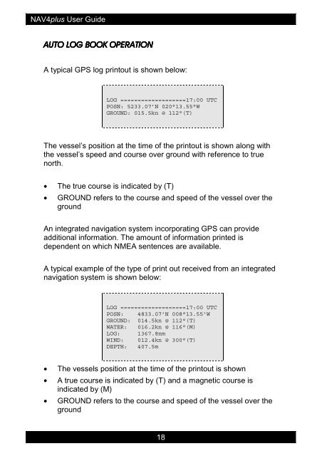
NAV4plus User Guide AUTO LOG BOOK OPERATION A typical GPS log printout is shown below: LOG ===================17:00 UTC POSN: 5233.07’N 020°13.55°W GROUND: 015.5kn @ 112°(T) The vessel’s position at the time of the printout is shown along with the vessel’s speed and course over ground with reference to true north. • The true course is indicated by (T) • GROUND refers to the course and speed of the vessel over the ground An integrated navigation system incorporating GPS can provide additional information. The amount of information printed is dependent on which NMEA sentences are available. A typical example of the type of print out received from an integrated navigation system is shown below: LOG ===================17:00 UTC POSN: 4833.07’N 008°13.55’W GROUND: 014.5kn @ 112°(T) WATER: 016.2kn @ 116°(M) LOG: 1367.8nm WIND: 012.4kn @ 300°(T) DEPTH: 407.5m • The vessels position at the time of the printout is shown • A true course is indicated by (T) and a magnetic course is indicated by (M) • GROUND refers to the course and speed of the vessel over the ground 18
NAV4plus User Guide • WATER refers to the course and speed of the vessel through the water • LOG is a running distance total as provided by the system speed log • WIND is displayed in the format provided by the wind instruments • DEPTH is displayed in the format provide by the depth sounder, including any keel offset set. Some depth sounders give out several different unit values (feet, meters, and fathoms) just the first value provided is selected for printing • When you first use the NAV4plus the position logging function is turned off Position logging can be turned on and set to give log printout at intervals of 15 and 30 minutes or 1, 3, 6 or 12 hours. Refer to the ‘NAV4plus Set-up’ section for details. The NAV4plus will automatically stop log printouts when you are alongside or at anchor, this is done by sensing that the GPS position is no longer changing. • Log printing will resume once the vessel’s movement over a 1nm line of position is detected • If you find that the log printout continues when you are moored up, it is possible that the ‘selective availability’ feature of the GPS satellite system is causing the vessels position to wander across a 1nm line of position. (Note that at the time of publishing, selective availability had been turned off by the US government). Do not turn the GPS off when in port if you intend to leave the NAV4plus running in AUTO NAVTEX. If you do, be prepared for a lot of printout as without a valid GPS position ALL NAVTEX STATIONS may be automatically selected. 19
- Page 1 and 2: Nav4plus User Guide January 2002 MA
- Page 3 and 4: NAV4plus User Guide Contents QUICK
- Page 5 and 6: NAV4plus User Guide QUICK START - G
- Page 7 and 8: NAV4plus User Guide What Can My Nav
- Page 9 and 10: NAV4plus User Guide HOW TO OPERATE
- Page 11 and 12: NAV4plus User Guide INITIAL OPERATI
- Page 13 and 14: NAV4plus User Guide For example, fo
- Page 15 and 16: NAV4plus User Guide CATEGORIES:A-CD
- Page 17: NAV4plus User Guide Stainless Steel
- Page 21 and 22: NAV4plus User Guide ALARMS The alar
- Page 23 and 24: NAV4plus User Guide Electrical Inst
- Page 25 and 26: NAV4plus User Guide NMEA CONNECTION
- Page 27 and 28: NAV4plus User Guide ANTENNA INSTALL
- Page 29 and 30: NAV4plus User Guide • Mount the a
- Page 31 and 32: NAV4plus User Guide MAINTENANCE AND
- Page 33 and 34: NAV4plus User Guide Printer Jam J M
- Page 35 and 36: NAV4plus User Guide PACKING LIST AN
- Page 37 and 38: NAV4plus User Guide APPENDIX I : NA
- Page 39 and 40: NAV4plus User Guide Remote Switch A
- Page 41 and 42: NAV4plus User Guide APPENDIX III :
- Page 43 and 44: NAV4plus User Guide Id Area Country
- Page 45 and 46: NAV4plus User Guide APPENDIX IV : M
<strong>NAV4</strong>plus <strong>User</strong> <strong>Guide</strong><br />
AUTO LOG BOOK OPERATION<br />
A typical GPS log printout is shown below:<br />
LOG ===================17:00 UTC<br />
POSN: 5233.07’N 020°13.55°W<br />
GROUND: 015.5kn @ 112°(T)<br />
The vessel’s position at the time of the printout is shown along with<br />
the vessel’s speed and course over ground with reference to true<br />
north.<br />
• The true course is indicated by (T)<br />
• GROUND refers to the course and speed of the vessel over the<br />
ground<br />
An integrated navigation system incorporating GPS can provide<br />
additional information. The amount of information printed is<br />
dependent on which NMEA sentences are available.<br />
A typical example of the type of print out received from an integrated<br />
navigation system is shown below:<br />
LOG ===================17:00 UTC<br />
POSN: 4833.07’N 008°13.55’W<br />
GROUND: 014.5kn @ 112°(T)<br />
WATER: 016.2kn @ 116°(M)<br />
LOG: 1367.8nm<br />
WIND: 012.4kn @ 300°(T)<br />
DEPTH: 407.5m<br />
• The vessels position at the time of the printout is shown<br />
• A true course is indicated by (T) and a magnetic course is<br />
indicated by (M)<br />
• GROUND refers to the course and speed of the vessel over the<br />
ground<br />
18


