
You also want an ePaper? Increase the reach of your titles
YUMPU automatically turns print PDFs into web optimized ePapers that Google loves.
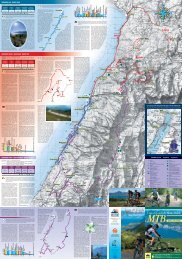
ADAMELLO – PRESANELLA (WEST SIDE)<br />
6. Sentiero delle Cascate<br />
Difficulty: easy / Time: 8-9 hours / Gradient: 800 mt<br />
Start from Ponte verde (900 mt), where you can find an info point of the Adamello –<br />
Brenta natural Park (gadgets shop, toilets), cross the bridge on the Sarca river and follow<br />
the path, going up the valley along the orografic right side of the rivere up to the Nardis<br />
Fall. It is pssible to start the walk 2 km before, at Carisolo “Antica Vetreria”.<br />
Going on, you reach the cnfluence of the Sarca river with the stream descending from Val<br />
Seniciaga; go slightly up t the first crossing and then turn to he right on the path which<br />
leads t an ample clearing (Malga genova) from where you can see the Lares Fall. The<br />
path ends to the head of the valley (15 km) shortly before Bedle Refuge. Many<br />
possibilities of leaving the path nearby the many refuges scattered along the valley<br />
( Cascate Nardis, Chalet da Gino, Fontanabona, Stella Alpina, bedole ).<br />
The way back is on the same path.<br />
Trail signs: “Sentier delle Cascate”<br />
7. Val di Genova – Malga Seniciaga Bassa<br />
Difficulty: medium / Time: 4-5 hours / Gradient: 653 mt<br />
Starting from Nardis Falls (927 mt) and climbing up along the road you find, on the left of<br />
the main road, a small way. Go on this road that after a while changes in path, cross the<br />
bridge on the Sarca river and follow the path which in this part is a little bit fatiguing.<br />
Then, overcome the first terrace, get out in the clearing of Malga of Malga Seniciaga<br />
bassa (1580 mt). Return by the same route.<br />
Trail signs: 215<br />
8. Val di Genova (Ponte Rsso) – Malga Lares<br />
Difficulty: medium-difficult / Time: 4-5 hours / Gradient: 770 mt<br />
From Ponte Rosso (1117 mt ) follow the path which climbs to along the Lares’ Fall and<br />
which reaches the summit. From here go on up to Malga Lares (1887 mt) crossing the<br />
bridge n the stream.<br />
Return by the same route.<br />
Trail signs: 215<br />
9. Val di Genova – Malga Nardis<br />
Difficulty: medium-difficult / Time: 4 hours / Gradient: 550 mt<br />
Start from the beginning of Val di Genova (Ponte Verde, 921 mt) for a path near the<br />
parking after the basin of Enel which climbs up quickly with bends and arrives at the<br />
clearing of Malga nardis (1471 mt).<br />
Return by the same route.<br />
Trail signs: 210<br />
10. Rifugio Bedole – Malga Matarot Bassa<br />
Difficulty: easy / Time: 2 hours / Gradient: 150 mt<br />
Frm Rifugio Bedole (1641 mt), follow the small road up to the clearing where the path<br />
climbs to Malga matarot Bassa (1790 mt). Here you enjoy a beautiful sight on the rock<br />
buttresses of the Lobbie.<br />
The way back is on the same route.<br />
Trail signs: 241