Selected Decisions and Documents - International Seabed Authority
Selected Decisions and Documents - International Seabed Authority
Selected Decisions and Documents - International Seabed Authority

You also want an ePaper? Increase the reach of your titles
YUMPU automatically turns print PDFs into web optimized ePapers that Google loves.
of the GIS Atlas an interactive web interface has been developed. The system is the most comprehensive<br />
global geographic information system on the deep seabed <strong>and</strong> its resources. The online tool aims to<br />
disseminate the available data on resource potential as well as other physical, political <strong>and</strong> environmental<br />
information. The different seabed features can be interactively displayed in various contexts <strong>and</strong> visually<br />
analysed at different scales. Relevant spatial information is constantly added with the objective to further<br />
compile a holistic, public geographical information system.<br />
90. Recognizing the fact that most of the data maintained by the secretariat are spatial data, the central<br />
data repository <strong>and</strong> the GIS has been integrated, allowing for a better underst<strong>and</strong>ing of spatial relationships.<br />
A common graphical interface for all of the secretariat’s public information systems has also been designed.<br />
As an integrated information <strong>and</strong> knowledge management system the redesigned central data repository<br />
interface will provide access to the searchable database of minerals sampling data, the digital atlas of the<br />
seabed, including its interactive web interface, the bibliographic database <strong>and</strong> the library catalogue <strong>and</strong> the<br />
patents database, as well as a section for scientific, economic <strong>and</strong> legal background information. Over the<br />
next year, the secretariat will continue its efforts to cooperate with national agencies <strong>and</strong> other research<br />
institutions so that it will be able to better provide geographic information in support of decision‐making by<br />
the bodies of the <strong>Authority</strong>.<br />
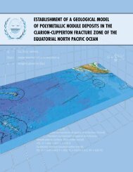
F. Ongoing assessment of available data relating to prospecting <strong>and</strong><br />
exploration for polymetallic nodules in the Clarion‐Clipperton zone<br />
91. During the period under review, the <strong>Authority</strong> continued work on the development of a geological<br />
model of polymetallic nodule deposits in the Clarion‐Clipperton zone. During 2008, Phase I of the project was<br />
completed <strong>and</strong> Phase II was taken up. The main tasks accomplished during 2008 were the following:<br />
(a)<br />
(b)<br />
(c)<br />
(d)<br />
(e)<br />
(f)<br />
(g)<br />
(h)<br />
Processing of all available resource data to produce 0.1 o ‐grid averages for posting on the<br />
<strong>Authority</strong>’s Virtual Private Network;<br />
Completion of a series of illustrative maps of available sediment data, using three‐dimensional<br />
modelling techniques;<br />
Examination of the tectonic <strong>and</strong> volcanic maps prepared under Phase I to produce a detailed<br />
report;<br />
Preparation of a report on the morphology of nodules <strong>and</strong> a study of the growth history of<br />
nodules in the Clarion‐Clipperton zone;<br />
Estimation of particulate organic carbonate carbon export fluxes with the study area, based on<br />
the available chlorophyll data;<br />
Preparation of an analysis using the Spatial Decision Support System programme suite to<br />
identify promising areas for exploration within the Clarion‐Clipperton zone <strong>and</strong> completion of<br />
maps of the potential nodule resources in the Clarion‐Clipperton zone from Spatial Decision<br />
Support System methods indicating areas with the highest potential;<br />
Construction of a database of estimated proxies of mineralization favourability in data poor<br />
areas;<br />
Improvement of the resource estimate of metal content <strong>and</strong> nodule abundances using<br />
appropriate methods including three‐dimensional modelling techniques, developing local scale<br />
maps from the three sites with detailed bathymetry data <strong>and</strong> examining the apparent<br />
relationship between bathymetry, metal content, <strong>and</strong> nodule abundances.<br />
92. The individual team member reports have subsequently been compiled into a single document of<br />
common format <strong>and</strong> the draft geological model <strong>and</strong> prospector’s guide have already been reviewed by the<br />
team members. The two documents are presently being peer‐reviewed by experts after which the documents<br />
20