

Magnitude 7.6 Earthquake Moro Gulf, Mindanao, Philippines ... - IRIS
Magnitude 7.6 Earthquake Moro Gulf, Mindanao, Philippines ... - IRIS
Magnitude 7.6 Earthquake Moro Gulf, Mindanao, Philippines ... - IRIS

You also want an ePaper? Increase the reach of your titles
YUMPU automatically turns print PDFs into web optimized ePapers that Google loves.
<strong>Magnitude</strong> <strong>7.6</strong> <strong>Earthquake</strong> <strong>Moro</strong> <strong>Gulf</strong>, <strong>Mindanao</strong>, <strong>Philippines</strong><br />
Friday, July 23, 2010 at 22:51:11 UTC<br />
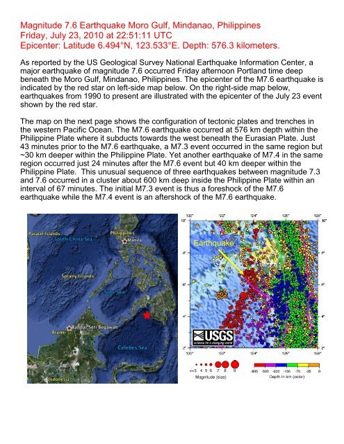
Epicenter: Latitude 6.494°N, 123.533°E. Depth: 576.3 kilometers.<br />
As reported by the US Geological Survey National <strong>Earthquake</strong> Information Center, a<br />
major earthquake of magnitude <strong>7.6</strong> occurred Friday afternoon Portland time deep<br />
beneath the <strong>Moro</strong> <strong>Gulf</strong>, <strong>Mindanao</strong>, <strong>Philippines</strong>. The epicenter of the M<strong>7.6</strong> earthquake is<br />
indicated by the red star on left-side map below. On the right-side map below,<br />
earthquakes from 1990 to present are illustrated with the epicenter of the July 23 event<br />
shown by the red star.<br />
The map on the next page shows the configuration of tectonic plates and trenches in<br />
the western Pacific Ocean. The M<strong>7.6</strong> earthquake occurred at 576 km depth within the<br />
Philippine Plate where it subducts towards the west beneath the Eurasian Plate. Just<br />
43 minutes prior to the M<strong>7.6</strong> earthquake, a M7.3 event occurred in the same region but<br />
~30 km deeper within the Philippine Plate. Yet another earthquake of M7.4 in the same<br />
region occurred just 24 minutes after the M<strong>7.6</strong> event but 40 km deeper within the<br />
Philippine Plate. This unusual sequence of three earthquakes between magnitude 7.3<br />
and <strong>7.6</strong> occurred in a cluster about 600 km deep inside the Philippine Plate within an<br />
interval of 67 minutes. The initial M7.3 event is thus a foreshock of the M<strong>7.6</strong><br />
earthquake while the M7.4 event is an aftershock of the M<strong>7.6</strong> earthquake.<br />
<strong>Earthquake</strong>
Eurasian<br />
Plate<br />
Taiwan<br />
Ryuku<br />
Trench<br />
Bonin<br />
Trench<br />
Pacific<br />
Plate<br />
Luzon<br />
Philippine Plate<br />
<strong>Mindanao</strong><br />
Philippine<br />
Trench<br />
Mariana<br />
Trench<br />
The earthquakes were too deep to cause a tsunami. Additionally, because of the<br />
depth, they were reported to be hardly felt, and no damage has been reported.<br />
Body waves travel through Earth's mantle from the earthquake to a distant station<br />
along paths that curve upwards because the velocity of seismic waves generally<br />
increases with depth in the mantle. However, direct P and S waves cannot travel to<br />
stations more than epicentral distance, Δ, of 103° because of the large decrease in<br />
seismic velocities across the boundary between the lower mantle and the liquid outer<br />
core. (Epicentral distance, Δ, is the angle formed by the intersection of the line from the<br />
earthquake to Earth's center with the line from the observing point to Earth's center.)<br />
There is a "shadow zone" for direct P waves in the range 103° < Δ < 143°. The S-wave<br />
shadow zone exists for Δ > 103° because the liquid outer core blocks S waves that<br />
cannot travel through liquids.
The record of the M<strong>7.6</strong> <strong>Moro</strong> <strong>Gulf</strong> earthquake on the University of Portland<br />
seismometer is illustrated below. Portland is about 11,279 km from the location of this<br />
earthquake and is at the edge of the shadow zone. The first arrival is small amplitude,<br />
and has a gradual onset, characteristics of a diffracted P wave arrival (Pdiff). This Pdiff<br />
is the first wave to arrive at Portland 771 seconds (12 minutes 51 seconds) after the<br />
earthquake. The second labeled arrival is pPdiff, a depth phase unique to deep<br />
earthquakes. This wave leaves the earthquake traveling towards the Earth’s surface<br />
where it is reflected back into the mantle to travel approximately the same path as the<br />
Pdiff to the seismic station. The pPdiff arrives to Portland 897 seconds (14 minutes<br />
57 seconds) after the earthquake, and the time difference between these two arrivals<br />
provides information about the depth of the earthquake. The next marked arrival on<br />
the record is a combination of a PP wave and a PKiKP wave which arrive<br />
simultaneously to Portland 1031 seconds (17 minutes 11 seconds) after the<br />
earthquake. PP is a compressive wave that traveled through Earth's mantle and<br />
bounced midway between the epicenter and Portland. PKiKP is a P wave that traveled<br />
a path from the earthquake through the mantle, outer core, inner core, outer core, and<br />
finally upwards through the mantle to the seismic station. The final labeled phase on<br />
this record is an SKS arrival. Since the distance to the earthquake puts Portland in the<br />
shadow zone for this earthquake, a direct S arrival is not expected. However the SKS<br />
is clear 1354 seconds (22 minutes 34 seconds) after the earthquake. SKS is a wave<br />
that leaves the earthquake as an S phase, converts to a P wave on the mantle – outer<br />
core boundary, travels through the outer core as a P wave, then converts back to an S<br />
wave as it travels upward through mantle – outer core boundary, arriving to the station<br />
as an S wave.


