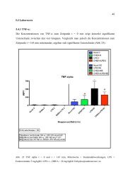
Urban Green Areas – their functions under a changing lifestyle of ...
Urban Green Areas – their functions under a changing lifestyle of ...
Urban Green Areas – their functions under a changing lifestyle of ...

Create successful ePaper yourself
Turn your PDF publications into a flip-book with our unique Google optimized e-Paper software.
The administrative organization and space planning was based on two elements: wards and<br />
streets. A ‘Ward’ was a basic administrative unit. Each ward provided a specific handicraft<br />
that give its name to the main street there. An imposing gate separated each ward. In<br />
general, each ward consisted <strong>of</strong> the people from one village who brought with them not<br />
only <strong>their</strong> particular <strong>lifestyle</strong> and customs but also <strong>their</strong> traditional construction technology.<br />
Each <strong>of</strong> the 36 craft streets was located and extended depending on the demands <strong>of</strong> trade<br />
and transportation. Other features such as small dykes and strips <strong>of</strong> high land were<br />
necessary and had <strong>their</strong> effects on wet-cultivation. Hence, the shape <strong>of</strong> each plot <strong>of</strong> land<br />
was not uniform and did not conform to any rules. Thus, the directions <strong>of</strong> those streets were<br />
determined by the natural terrain. The streets were short and narrow.<br />
1.2.1.2 Hanoi’s plans 1885-1945 (CHIEN 2006)<br />
Construction works initited by the French in Hanoi were designed to support <strong>their</strong> political<br />
goal <strong>of</strong> "exploited colonization" in both the periods 1885-1920 and 1920-1945.<br />
In the initial period, the construction <strong>of</strong> military works in the southeast was implemented<br />
from the "concessions" area, which the last feudal king had ceded to the French. Then<br />
important administrative works were also constructed to the east <strong>of</strong> the Hoan Kiem lake.<br />
Picture 1.1a: Trang Tien street<br />
Picture 1.1b: Hang Bai street<br />
Hanoi in the beginning <strong>of</strong> the XX century. Source: (DIEULEFILS, Pierre n.d.)<br />
The overall architecture created a well-matched spatial axis from the flower garden Bank<br />
overlooking Hoan Kiem lake to the Paul Bert street (recently Trang Tien street), (see<br />
Picture 1a,b), (see CHIEN 2006). This plan marks the first urban green areas, which were<br />
designed in Hanoi, following the French style.<br />
In the second period, colonial exploitation was increased. The French government<br />
implemented projects built for the administration, and formed the ‘western streets’ which<br />
were designed by French planners.<br />
In 1921, an urban architecture unit was established in Hanoi with the architect Ernest<br />
Hesbrard as the president <strong>of</strong> the unit. In 1924, he designed a Hanoi master plan that was<br />
used as the foundation to manage the city. All constructions had to comply with the plan to<br />
balance urban space with the tight lay-out intended to symbolise the specifically French<br />
features <strong>of</strong> the plan and architecture. In addition, the "36 streets" were reorganized; the city<br />
6