User manual - JG Technologies
User manual - JG Technologies
User manual - JG Technologies

Create successful ePaper yourself
Turn your PDF publications into a flip-book with our unique Google optimized e-Paper software.
Ground trip resets menu<br />
This menu enables you to resets the chosen ground trip distance counter to zero.<br />
Menu item<br />
Description<br />
Ground Trip 1 Reset<br />
Resets the ground trip 1 distance counter to zero.<br />
Ground Trip 2 Reset<br />
Resets the ground trip 2 distance counter to zero.<br />
Ground Trip 3 Reset<br />
Resets the ground trip 3 distance counter to zero.<br />
Ground Trip 4 Reset<br />
Resets the ground trip 4 distance counter to zero.<br />
System settings menu<br />
GPS setup<br />
The GPS setup options enable you to configure a connected GPS<br />
receiver.<br />
The Global Positioning System (GPS) is used to position your vessel<br />
on the chart. You can set up your GPS receiver and check its status<br />
from the GPS Status option in the System Settings menu. For<br />
each tracked satellite, the screen provides the following information:<br />
• Satellite number.<br />
• Signal strength bar.<br />
• Status.<br />
• Azimuth angle.<br />
• Elevation angle.<br />
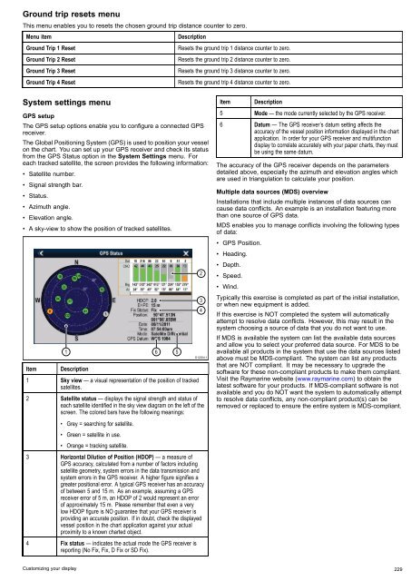
• A sky-view to show the position of tracked satellites.<br />
Item<br />
1<br />
Description<br />
1 Sky view — a visual representation of the position of tracked<br />
satellites.<br />
6<br />
5<br />
2<br />
3<br />
4<br />
D12204-1<br />
2 Satellite status — displays the signal strength and status of<br />
each satellite identified in the sky view diagram on the left of the<br />
screen. The colored bars have the following meanings:<br />
• Grey = searching for satellite.<br />
• Green = satellite in use.<br />
• Orange = tracking satellite.<br />
3 Horizontal Dilution of Position (HDOP) — a measure of<br />
GPS accuracy, calculated from a number of factors including<br />
satellite geometry, system errors in the data transmission and<br />
system errors in the GPS receiver. A higher figure signifies a<br />
greater positional error. A typical GPS receiver has an accuracy<br />
of between 5 and 15 m. As an example, assuming a GPS<br />
receiver error of 5 m, an HDOP of 2 would represent an error<br />
of approximately 15 m. Please remember that even a very<br />
low HDOP figure is NO guarantee that your GPS receiver is<br />
providing an accurate position. If in doubt, check the displayed<br />
vessel position in the chart application against your actual<br />
proximity to a known charted object.<br />
4 Fix status — indicates the actual mode the GPS receiver is<br />
reporting (No Fix, Fix, D Fix or SD Fix).<br />
Item<br />
Description<br />
5 Mode — the mode currently selected by the GPS receiver.<br />
6 Datum — The GPS receiver’s datum setting affects the<br />
accuracy of the vessel position information displayed in the chart<br />
application. In order for your GPS receiver and multifunction<br />
display to correlate accurately with your paper charts, they must<br />
be using the same datum.<br />
The accuracy of the GPS receiver depends on the parameters<br />
detailed above, especially the azimuth and elevation angles which<br />
are used in triangulation to calculate your position.<br />
Multiple data sources (MDS) overview<br />
Installations that include multiple instances of data sources can<br />
cause data conflicts. An example is an installation featuring more<br />
than one source of GPS data.<br />
MDS enables you to manage conflicts involving the following types<br />
of data:<br />
• GPS Position.<br />
• Heading.<br />
• Depth.<br />
• Speed.<br />
• Wind.<br />
Typically this exercise is completed as part of the initial installation,<br />
or when new equipment is added.<br />
If this exercise is NOT completed the system will automatically<br />
attempt to resolve data conflicts. However, this may result in the<br />
system choosing a source of data that you do not want to use.<br />
If MDS is available the system can list the available data sources<br />
and allow you to select your preferred data source. For MDS to be<br />
available all products in the system that use the data sources listed<br />
above must be MDS-compliant. The system can list any products<br />
that are NOT compliant. It may be necessary to upgrade the<br />
software for these non-compliant products to make them compliant.<br />
Visit the Raymarine website (www.raymarine.com) to obtain the<br />
latest software for your products. If MDS-compliant software is not<br />
available and you do NOT want the system to automatically attempt<br />
to resolve data conflicts, any non-compliant product(s) can be<br />
removed or replaced to ensure the entire system is MDS-compliant.<br />
Customizing your display 229