

lough key local area plan 2009 - 2015 - Roscommon County Council
lough key local area plan 2009 - 2015 - Roscommon County Council
lough key local area plan 2009 - 2015 - Roscommon County Council

Create successful ePaper yourself
Turn your PDF publications into a flip-book with our unique Google optimized e-Paper software.
LOUGH KEY<br />
LOCAL AREA PLAN<br />
<strong>2009</strong> - <strong>2015</strong><br />
MADE ON 21 st DECEMBER <strong>2009</strong><br />
<strong>Roscommon</strong> <strong>County</strong> <strong>Council</strong><br />
Comhairle Chontae Ros Comáin
<strong>Roscommon</strong> <strong>County</strong> <strong>Council</strong><br />
LOUGH KEY LAP<br />
TABLE OF CONTENTS<br />
1. INTRODUCTION 1<br />
1.1 Introduction and Context 1<br />
1.2 Legislative and Policy Context 1<br />
1.3 Physical Context 2<br />
1.4 Preparation of the Lough Key Local Area Plan 3<br />
1.5 Strategic Environmental Assessment 4<br />
1.6 Appropriate Assessment 4<br />
1.7 Further Reference 5<br />
2. CONTEXT AND PROFILE OF LOUGH KEY 7<br />
2.1 Introduction 7<br />
2.2 Location of Lough Key 7<br />
2.3 Description of the Lough Key Plan Area 7<br />
2.3.1 Brief History of the Lough Key Area 9<br />
2.3.2 Brief History of some of the Sites in the Lough Key Area 10<br />
3. SETTLEMENT POLICY AND DEVELOPMENT STRATEGY 13<br />
3.1 Context 13<br />
3.2 Overview and Strategic Vision 13<br />
3.3 Population Context 14<br />
3.3.1 Population Calculations 14<br />
3.3.2 2006 Census Information 14<br />
3.3.3 An Post Geo-Directory 15<br />
3.3.4 Population Projections 15<br />
3.4 Settlement Structure and Strategy 15<br />
4. INFRASTRUCTURE AND SERVICES 19<br />
4.1 Introduction 19<br />
4.2 Roads and Transportation 19<br />
4.2.1 Policy Context 19<br />
4.2.2 Public Transport 19<br />
4.2.3 Roads and Transportation Strategy 21<br />
4.3 General Infrastructure 23<br />
4.3.1 Marinas 23<br />
4.4 Water Services 25<br />
4.4.1 Policy Context 25<br />
4.4.2 Physical Context 26<br />
4.4.3 Water Quality 27<br />
4.4.4 Water Services Strategy 28<br />
4.5 Flood Risk and Protection 30<br />
4.5.1 Policy Context 30<br />
4.5.2 Physical Context 30<br />
4.5.3 Flood Risk and Protection Strategy 30<br />
4.6 Wastewater Services 32<br />
4.6.1 Policy Context 32<br />
4.6.2 Physical Context 33<br />
4.6.3 Serviced Land Initiatives 33<br />
4.6.4 Wastewater Services Strategy 33<br />
4.7 Waste Management 35<br />
4.8 Energy 37<br />
4.8.1 Policy Context 37<br />
4.8.2 Renewable Energy 37<br />
Lough Key Local Area Plan <strong>2009</strong>-<strong>2015</strong>
<strong>Roscommon</strong> <strong>County</strong> <strong>Council</strong><br />
LOUGH KEY LAP<br />
4.8.3 Electricity 38<br />
4.8.4 Gas 39<br />
4.8.5 Energy Strategy 40<br />
4.9 Telecommunications 41<br />
4.9.1 Broadband 41<br />
4.9.2 Mobile Phone Network Development 41<br />
4.9.3 Telecommunications Strategy 42<br />
5. ECONOMIC DEVELOPMENT AND EMPLOYMENT 45<br />
5.1 Introduction 45<br />
5.2 Policy Context 45<br />
5.3 Economic Profile 46<br />
5.4 Future Economic Strategy 48<br />
5.5 Rural Enterprises in Towns and Villages 51<br />
5.6 Tourism 52<br />
5.7 Retail and Commercial Development 53<br />
5.8 Industrial Development 55<br />
5.9 Office Development 56<br />
5.10 Economic Development and Employment Strategy 56<br />
6. BUILT AND NATURAL HERITAGE 57<br />
6.1 Introduction 57<br />
6.1.1 Architectural Heritage 57<br />
6.1.2 Archaeological Heritage 64<br />
6.1.3 Heritage Gardens, Parks and Demesnes 77<br />
6.1.4 Built Heritage Strategy 78<br />
6.2 Natural Heritage 80<br />
6.2.1 Designated Sites 80<br />
6.2.2 Nature Conservation, the Wider Countryside and Biodiversity 82<br />
6.2.3 Sites of Geological Importance and Eskers 84<br />
6.2.4 Hedgerows 85<br />
6.2.5 Trees and Woodlands 85<br />
6.2.6 Peatlands 86<br />
6.2.7 Wetlands 86<br />
6.2.8 Inland Waters 87<br />
6.2.9 Alien Species 87<br />
6.3 Landscape Character Assessment 89<br />
7. SOCIAL AND COMMUNITY FACILITIES 113<br />
7.1 Introduction 113<br />
7.2 Policy Context 113<br />
7.3 Physical Context 114<br />
7.3.1 Community Facilities 114<br />
7.3.2 Schools and Educational Facilities 117<br />
7.3.3 Social Inclusion and Disability 117<br />
7.3.4 Childcare Provision 117<br />
7.3.5 Health Care 118<br />
7.3.6 Burial Grounds 119<br />
7.3.7 Community Development Fora 119<br />
7.4 Social and Community Facilities Strategy 120<br />
8. RECREATION, LEISURE AND TOURISM 123<br />
8.1 Introduction 123<br />
8.2 Policy Context 123<br />
Lough Key Local Area Plan <strong>2009</strong>-<strong>2015</strong>
<strong>Roscommon</strong> <strong>County</strong> <strong>Council</strong><br />
LOUGH KEY LAP<br />
8.3 Physical Context 123<br />
8.3.1 Open Space and Sporting Provision 123<br />
8.3.2 Integrated Tourism and Recreation Development 124<br />
8.3.3 Tourism 125<br />
8.4 Recreation, Leisure and Tourism Strategy 134<br />
9. URBAN AND RURAL DEVELOPMENT WITHIN THE LAP AREA 137<br />
9.1 Introduction and Context 137<br />
9.2 Policy Context 137<br />
9.2.1 National and Regional Policy Context 137<br />
9.2.2 Local Context 146<br />
9.3 Physical Context 147<br />
9.3.1 Housing Strategy and Residential Development 147<br />
9.3.2 Land Use Zoning Objectives and Matrix 148<br />
9.4 Village Development 167<br />
9.5 Design Guidelines for Residential Development in the<br />
Environs of Lough Key 169<br />
9.6 Architecture and Design 174<br />
9.7 Sustainable Energy and Design 175<br />
9.8 Overall Strategy for Development within the Plan Area 176<br />
10. DEVELOPMENT MANAGEMENT GUIDELINES AND STANDARDS 179<br />
10.1 Introduction 179<br />
10.2 General Development 179<br />
10.2.1 Building Lines 179<br />
10.2.2 Access for Persons with Disabilities and the Mobility Impaired 179<br />
10.2.3 Light Pollution 180<br />
10.2.4 Noise 180<br />
10.2.5 Drainage 180<br />
10.2.6 Conservation of Water 180<br />
10.2.7 Wastewater Treatment 181<br />
10.2.8 Flood Risk and Protection 181<br />
10.3 RESIDENTIAL DEVELOPMENT (To be read in conjunction<br />
with Chapter 9) 182<br />
10.3.1 Residential Development (Qualitative) 182<br />
10.3.2 Residential Development (Quantitative) 183<br />
10.3.3 Residential Density 184<br />
10.3.4 Residential Site Development Standards 185<br />
10.3.5 Apartments 186<br />
10.3.6 House Extensions 187<br />
10.3.7 Backland Development 188<br />
10.3.8 Use of Upper Floors for Residential Purposes 189<br />
10.3.9 Change of Use of Existing Houses in Existing<br />
Residential Schemes 189<br />
10.3.10 Derelict Sites 189<br />
10.3.11 Residential Care Homes 189<br />
10.3.12 Parking in Front Gardens 189<br />
10.4 Retail Development (To be read in conjunction with Chapters 5) 190<br />
10.4.1 Shop Fronts 191<br />
10.4.2 Shopping Centres 191<br />
10.5 Office/Industrial Developments (To be read in conjunction<br />
with Chapters 5) 192<br />
10.5.1 Office Development 192<br />
10.5.2 Industry, Warehousing and Business Park Developments 192<br />
Lough Key Local Area Plan <strong>2009</strong>-<strong>2015</strong>
<strong>Roscommon</strong> <strong>County</strong> <strong>Council</strong><br />
LOUGH KEY LAP<br />
10.6 Convenience Food Shopping (To be read in conjunction with<br />
Chapter 5) 192<br />
10.7 Discount Food Stores (To be read in conjunction with Chapter 5) 193<br />
10.8 District, Neighbourhood and Local Centres<br />
(To be read in conjunction with Chapter 5) 193<br />
10.9 Retail Warehouse Parks (To be read in conjunction with Chapter 5) 193<br />
10.10 Factory Outlet Centres (To be read in conjunction with Chapter 5) 193<br />
10.11 Retail Warehouse Clubs (To be read in conjunction with Chapter 5) 193<br />
10.12 Local Shops and Petrol Filling Stations (To be read in conjunction<br />
with Chapter 5) 194<br />
10.13 Pubs/Nightclubs/Amusement Centres 195<br />
10.14 Fast Food Outlets/Take-Aways 195<br />
10.15 Automatic Teller Machines 195<br />
10.16 Advertising 196<br />
10.16.1 Advertising Hoardings 196<br />
10.16.2 Fingerpost Signage 197<br />
10.16.3 Rural Advertising 197<br />
10.17 Tourism (To be read in conjunction with Chapter 8) 197<br />
10.17.1 Rural Tourism 198<br />
10.17.2 Caravan and Camping Parks 198<br />
10.17.3 Holiday Homes 199<br />
10.17.4 Tourist Advertisements 199<br />
10.17.5 Diversification 199<br />
10.17.6 Recreation (To be read in conjunction with Chapter 8) 199<br />
10.17.7 Sustainable Tourism Planning Control Checklist 201<br />
10.18 Community Facilities 202<br />
10.19 Schools 202<br />
10.20 Nursing Homes 202<br />
10.21 Childcare Facilities 203<br />
10.22 Neighbourhood Facilities 203<br />
10.23 Car Parking 203<br />
10.23.1 Loading and Unloading 206<br />
10.23.2 Heavy Vehicles 206<br />
10.23.3 Cycle Facilities 206<br />
10.24 Transport (To be read in conjunction with Chapter 4 of this LAP and<br />
Chapter 6 of the RCDP 2008 - 2014) 206<br />
10.24.1 National and Regional Roads 207<br />
10.24.2 Sightlines 207<br />
10.24.3 Public Transport 207<br />
10.25 Renewable Energy/Efficiency<br />
(To be read in conjunction with Chapter 4) 207<br />
10.25.1 Micro Renewables 208<br />
10.25.2 Energy Conservation 209<br />
10.25.3 Planning Exemptions for Renewable Technology 209<br />
10.26 Heritage Protection (To be read in conjunction with<br />
Chapter 6) 211<br />
10.26.1 Architectural Conservation – Protected Structures 211<br />
10.26.2 Development in Architectural Conservation Areas 212<br />
10.26.3 Development in Areas of Archaeological Potential 212<br />
10.27 Telecommunications (To be read in conjunction with Chapter 4) 213<br />
10.28 Extractive Industry (To be read in conjunction with<br />
Chapter 3 of the RCDP 2008 – 2014) 213<br />
10.29 Forestry (To be read in conjunction with Chapter 6 of the<br />
RCDP 2008 - 2014) 215<br />
Lough Key Local Area Plan <strong>2009</strong>-<strong>2015</strong>
<strong>Roscommon</strong> <strong>County</strong> <strong>Council</strong><br />
LOUGH KEY LAP<br />
10.30 Inland Fisheries 216<br />
10.30.1 River Drainage 216<br />
10.30.2 Other Works 216<br />
10.31 Bonding to secure completion of a Development 217<br />
10.32 Future Publications, Guidelines and Standards 217<br />
LIST OF TABLES<br />
Table 1: Population Statistics for 2002 and 2006 in each DED <strong>area</strong> 14<br />
Table 2: Protected Structures and Potential Protected Structures<br />
In the Lough Key Plan Area 62<br />
Table 3: National Monuments within the Lough Key Plan Area 64<br />
Table 4: Recorded Monuments and Places within the<br />
Lough Key Plan Area 65<br />
Table 5: Special Area of Conservation (SAC) close to the<br />
Lough Key Plan Area 81<br />
Table 6: Special Protection Area (SPA) close to the Lough Key Plan Area 81<br />
Table 7: Proposed Natural Heritage Areas (pNHA) within the<br />
Lough Key Plan Area 81<br />
Table 8: Places of Interest/Visitor Attractions in and around Lough Key 127<br />
Table 9: Minimum Floor Area Requirements for Apartments 187<br />
Table 10: Car Parking Requirements 204<br />
LIST OF FIGURES<br />
Figure 1: Groundwater Vulnerability in Lough Key 27<br />
LIST OF MAPS<br />
1. Location Map<br />
2. Infrastructure & Services Map<br />
3. Built Heritage<br />
4. Natural Heritage<br />
5. Social and Community Facilities<br />
6. Recreation, Leisure and Tourism<br />
7. Opportunity Sites and Constraints Map<br />
8. Land-use Zoning Map<br />
Lough Key Local Area Plan <strong>2009</strong>-<strong>2015</strong>
<strong>Roscommon</strong> <strong>County</strong> <strong>Council</strong><br />
LOUGH KEY LAP<br />
LIST OF ABBREVIATIONS<br />
LAP<br />
RCDP<br />
RCC<br />
SEA<br />
AA<br />
DED<br />
NDP<br />
RPG<br />
SUDS<br />
SPA<br />
cSAC<br />
NHA<br />
EIA<br />
LCA<br />
ACA<br />
BER<br />
DoEHLG<br />
SME<br />
Local Area Plan<br />
<strong>Roscommon</strong> <strong>County</strong> Development Plan<br />
<strong>Roscommon</strong> <strong>County</strong> <strong>Council</strong><br />
Strategic Environmental Assessment<br />
Appropriate Assessment<br />
District Electoral Division<br />
National Development Plan<br />
Regional Planning Guidelines<br />
Sustainable Urban Drainage Systems<br />
Special Protection Area<br />
Candidate Special Area of Conservation<br />
National Heritage Area<br />
Environmental Impact Assessment<br />
Landscape Character Assessment<br />
Architectural Conservation Area<br />
Building Energy Rating<br />
Department of Environment Heritage and Local Government<br />
Small and Medium Enterprise<br />
Lough Key Local Area Plan <strong>2009</strong>-<strong>2015</strong>
Chapter 1: Introduction<br />
1.1 INTRODUCTION AND CONTEXT<br />
In accordance with the Planning and Development Act 2000, as amended, the <strong>Roscommon</strong> <strong>County</strong><br />
Development Plan (RCDP) 2008-2014, was adopted in June 2008. This Plan outlined a commitment to<br />
prepare and adopt Local Area Plans for various <strong>area</strong>s within Co. <strong>Roscommon</strong>, including Lough Key.<br />
The Lough Key Local Area Plan (LAP) is prepared in accordance with Section 19 (2) of the Planning<br />
and Development Act 2000, as amended.<br />
What is a Local Area Plan (LAP)?<br />
An LAP is made up of a written statement and maps, <strong>plan</strong>s and drawings setting out objectives for the<br />
proper <strong>plan</strong>ning and sustainable development of a specific <strong>area</strong>. The LAP takes a detailed look at a<br />
specific <strong>area</strong>, identifying and analysing the various issues of relevance, before establishing and setting<br />
out principles for the future development of the <strong>area</strong>. The objectives indicated in the <strong>plan</strong> must be<br />
relevant to the <strong>local</strong> <strong>area</strong> and consistent with the provisions of the <strong>Roscommon</strong> <strong>County</strong> Development<br />
Plan 2008 – 2014. The intended timescale for the implementation of the <strong>plan</strong> must be stated and<br />
information included on the likely significant effects on the environment of implementing the Plan.<br />
An LAP is a legal or statutory document prepared in accordance with Part II, Sections 18 to 20 of the<br />
Planning and Development Acts 2000 – 2006. When considering an application for <strong>plan</strong>ning<br />
permission within the boundary of a LAP <strong>area</strong>, the Planning Authority and An Bord Pleanala must<br />
take account of the provisions set out in the LAP. The provisions of any Draft LAP may also be<br />
considered.<br />
Public consultation is particularly important in its preparation and the making of the LAP is the<br />
responsibility of the elected members of the <strong>County</strong> <strong>Council</strong>.<br />
The Lough Key LAP has been prepared in accordance with the requirements of Section 19(2) of the<br />
Planning and Development Act 2000, as amended. It consists of a written framework, accompanied by<br />
relevant maps and appendices. The following sections contain the main policy material under a range<br />
of headings together with the strategies, policies and objectives which support them. The main<br />
sections are as follows: -<br />
• Context and Profile of the Lough Key <strong>area</strong>.<br />
• Settlement Policy and Development Strategy<br />
• Infrastructure and Services<br />
• Economic Development and Employment<br />
• Built and Natural Heritage<br />
• Social and Community Facilities<br />
• Recreation, Leisure and Tourism<br />
• Village Development<br />
• Development Management Guidelines and Standards<br />
In the interests of clarity, any reference to a goal, aim, policy and objective in the text of this Local<br />
Area Plan, shall be construed as an “objective” of this Plan for the purposes of the Planning and<br />
Development Act, 2000 as amended and the Planning and Development Regulations, 2001 as<br />
amended.<br />
1.2 LEGISLATIVE AND POLICY CONTEXT<br />
This LAP is set within a hierarchy of Plans at National, Regional and Local levels. These primarily<br />
include: -<br />
The need to promote “sustainable development” is paramount. This term refers to “development that<br />
meets the needs of the present without compromising the ability of future generations to meet their<br />
Lough Key Local Area Plan <strong>2009</strong>-<strong>2015</strong> Page 1
Chapter 1: Introduction<br />
own needs”. This principle lies at the heart of the LAP and its aims, as in the various European Union<br />
publications such as Agenda 2000, Local Agenda 21, the European Spatial Development Perspective<br />
(ESDP), and various relevant EU Directives.<br />
The <strong>Roscommon</strong> <strong>County</strong> Development Plan (RCDP) 2008 – 2014 consists of a single document<br />
comprising the <strong>County</strong> Development Plan as well as Area Plans for all the towns together with zoning<br />
maps. These <strong>plan</strong>s provide updated information concerning the towns and a guidance framework for<br />
the management of development in an environmentally sustainable manner within the development<br />
envelopes of the towns. These will continue to operate as statutory <strong>plan</strong>s for the <strong>area</strong>s until such time<br />
as Local Area Plans, as defined in Part II, Chapter II of the Planning and Development Act 2000, as<br />
amended, replace them. The Lough Key Local Area Plan is one of the first to be prepared and once<br />
adopted the RCDP will be varied to allow the Lough Key LAP to replace the Area Plan contained<br />
within it.<br />
National Level<br />
The National Development Plan (NDP) 2007-2013, Sustainable Development: A Strategy for Ireland,<br />
1997 National Spatial Strategy (NSS) 2002-2020 and other Planning Guidelines.<br />
Regional Level<br />
The Regional Planning Guidelines (RPG’s) for the West 2004-2016 and the Midland Regional<br />
Authority: Regional Planning Guidelines 2004.<br />
Local Level<br />
The <strong>Roscommon</strong> <strong>County</strong> Development Plan 2008-2014 and the “<strong>Roscommon</strong> Common Vision”,<br />
<strong>County</strong> Development Board Strategy, 2002-2012.<br />
Various other relevant guidelines regarding elements such as retailing, telecommunications, Built<br />
Heritage, Sustainable Rural Housing, Quarries etc. have also informed the objectives and policies set<br />
out in this LAP.<br />
1.3 PHYSICAL CONTEXT<br />
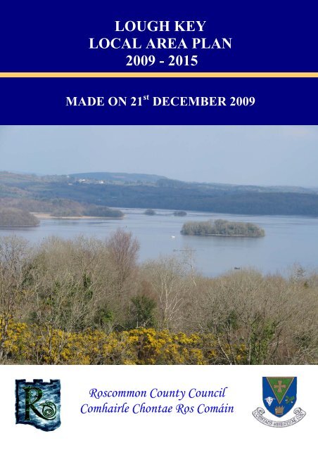
Lough Key is located just east of Boyle, in <strong>County</strong> <strong>Roscommon</strong>. It comprises approximately 350<br />
hectares of mixed woodlands, open parkland, a lake, and a number of mature wooded islands. Lough<br />
Key and its surrounding landscape form part of an <strong>area</strong> of outstanding natural beauty, which is also of<br />
considerable recreational importance.<br />
Lough Key is identified as a significant resource for the economic and social development of North<br />
<strong>Roscommon</strong>. This <strong>area</strong> is regarded as a <strong>key</strong> <strong>area</strong> of the <strong>County</strong> to foster and enhance a strong tourism<br />
industry. The Lough Key <strong>area</strong> also attracts a significant level of pressure for residential development.<br />
Given the sensitive nature of the <strong>area</strong>, significant developments in the Lough Key <strong>area</strong> require careful<br />
consideration.<br />
The purpose of this Local Area Plan (LAP) is to conserve and enhance the natural and built<br />
environment of the Lough Key <strong>area</strong> through appropriate development policies. It is important to have<br />
a legislative <strong>plan</strong>ning framework in place, which will guide and enhance the appropriate development<br />
of this <strong>area</strong> of <strong>County</strong> <strong>Roscommon</strong>.<br />
Lough Key Local Area Plan <strong>2009</strong>-<strong>2015</strong> Page 2
Chapter 1: Introduction<br />
1.4 PREPARATION OF THE LOUGH KEY LAP<br />
The following is a summary of the timescale and processes involved in the preparation and adoption of<br />
a Local Area Plan (LAP).<br />
1. Pre-draft consultation<br />
Prior to preparing the Draft LAP, the <strong>local</strong> authority consults with the public concerning the<br />
preparation of the Plan.<br />
2. Preparation of the Draft LAP<br />
The <strong>County</strong> <strong>Council</strong> then prepares the Draft LAP taking into account the issues raised during the predraft<br />
consultation phase.<br />
3. Public Notice and LAP display period<br />
An advertisement is placed in several <strong>local</strong> newspapers announcing the preparation of the LAP. Notice<br />
and a copy of the Draft LAP is also sent to the prescribed bodies including government agencies.<br />
The Draft LAP goes on display for a minimum period of 6 weeks during which submissions and<br />
observations are invited from the public and interested parties.<br />
4. Preparation of Manager’s Report on submissions/observations<br />
A report summarising the issues raised in the submissions and the manager’s recommendation is<br />
presented to the elected members of the <strong>County</strong> <strong>Council</strong> not later than 12 weeks after publication of<br />
the notice in the national newspaper. The elected members have 6 weeks to consider the report and<br />
adopt, amend, or reject the <strong>plan</strong><br />
5. Display of proposed amendments<br />
Any material amendment to the <strong>plan</strong> must go on display for a period of not less than 4 weeks.<br />
6. Preparation on Manager’s Report on submissions on Proposed Amendments<br />
A manager’s report summarising the issues raised in the submissions and the recommendation of the<br />
manager is presented to the elected members of the <strong>County</strong> <strong>Council</strong>. This takes places not later then 8<br />
weeks after publication of the notice in the national newspaper. The elected members have a<br />
maximum of 6 weeks to consider the report and adopt, amend, or reject the <strong>plan</strong>.<br />
Lough Key Local Area Plan <strong>2009</strong>-<strong>2015</strong> Page 3
Chapter 1: Introduction<br />
1.5 STRATEGIC ENVIRONMENTAL ASSESSMENT<br />
Strategic Environmental Assessment (SEA) is the formal systematic evaluation of the likely significant<br />
environmental effects of implementing the Local Area Plan before a decision is made to adopt the <strong>plan</strong>.<br />
The procedures for this evaluation are set out in the Planning and Development (SEA) Regulations,<br />
2004.<br />
The preparation of a full SEA is not mandatory for Local Area Plans with a population of less than<br />
10,000, persons such as the Lough Key LAP. However, in accordance with the SEA Regulations, the<br />
<strong>plan</strong>ning authority must establish whether or not the implementation of such a proposed <strong>plan</strong> would be<br />
likely to have a significant impact on the environment, and therefore require an SEA.<br />
The SEA process involves: -<br />
Screening, which is the process used to determine whether an SEA is required and whether<br />
‘appropriate assessments’ are required due to the <strong>plan</strong>’s activities under the EC Directive on the<br />
Conservation of Natural Habitats of Wild Fauna and Flora 92/43/EEC 1992 (the ‘Habitats Directive’).<br />
Scoping, is necessary to determine the "boundaries" and coverage of the SEA, regarding such things as<br />
level of detail needed, and helps to focus the SEA on <strong>key</strong> aspects of the environment, notably those<br />
which the proposals are likely to affect, and particularly those which are of importance, such as<br />
internationally important wildlife sites, etc<br />
Preparation of an Environmental Report, which identifies and evaluates the likely significant<br />
environmental impact of an adopted <strong>plan</strong>.<br />
Consultation with the public, environmental authorities and any EU Member State affected regarding<br />
the environmental report and <strong>plan</strong>.<br />
Assessing the findings of the report and feedback from consultations to establish if it is necessary to<br />
adopt or modify the <strong>plan</strong>.<br />
Declaration on the decision to adopt the <strong>plan</strong> and how the SEA influenced the <strong>plan</strong>.<br />
This LAP is subject to a Strategic Environmental Assessment (SEA), as required by the Planning and<br />
Development (Strategic Environmental Assessment) Regulations 2004. The screening report has<br />
determined that this <strong>plan</strong> will not have a significant effect on the environment. This ‘screening<br />
decision; and the reasons for it, have been made available for public inspection and notified to the<br />
prescribed authorities as required in accordance with Article 14A (6) of the abovementioned<br />
legislation.<br />
1.6. APPROPRIATE ASSESSMENT<br />
Article 6(3) and (4) of the Habitats Directive 92/43/EEC requires an appropriate assessment of land<br />
use <strong>plan</strong>s with respect to the ecological implications of any <strong>plan</strong> or project, whether within or outside a<br />
designated site, which does not directly relate to the management of the site but may impact upon its<br />
conservation objectives. The impact is assessed on Natura 2000 sites which are designed to form an<br />
ecologically coherent network of designated sites across the whole of Europe. These sites consist of<br />
Special Areas of Conservation (SACs) and Special Protection Areas (SPAs).<br />
The process followed for the appropriate assessment is similar to that carried out for the Strategic<br />
Environmental Assessment;<br />
• Screening: the process which identifies the likely impacts upon a Natura 2000 site of a<br />
project or <strong>plan</strong>, either alone or in combination with other projects or <strong>plan</strong>s, and considers<br />
whether these impacts are likely to be significant.<br />
Lough Key Local Area Plan <strong>2009</strong>-<strong>2015</strong> Page 4
Chapter 1: Introduction<br />
• Appropriate Assessment: the consideration of the impact on the integrity of the Natura<br />
2000 site of the project or <strong>plan</strong>, either alone or in combination with other projects or <strong>plan</strong>s,<br />
with respect to the site’s structure and function and its conservation objectives. Additionally,<br />
where there are adverse impacts, an assessment of the potential mitigation of those impacts.<br />
• Assessment of alternative solutions: the process which examines alternative ways of<br />
achieving the objectives of the project or <strong>plan</strong> that avoid adverse impacts on the integrity of<br />
the Natura 2000 site.<br />
• Assessment where no alternative solutions exist and where adverse impacts remain: an<br />
assessment of compensatory measures where, in the light of an assessment of imperative<br />
reasons of overriding public interest (IROPI), it is deemed that the project or <strong>plan</strong> should<br />
proceed (it is important to note that this guidance does not deal with the assessment of<br />
imperative reasons of overriding public interest).<br />
The purpose of the Screening Report prepared for the Appropriate Assessment is to consider whether,<br />
based on the best scientific knowledge, the Plan will have potential impacts on the conservation<br />
objectives of any Natura 2000 sites, and if so, the development, where necessary, of mitigation or<br />
avoidance measures to preclude negative effects. The report has been conducted in accordance with<br />
the Methodological Guidance on the Provisions of Article 6(3) and (4) of the Habitats Directive<br />
92/43/EEC.<br />
The LAP has been formulated to ensure that uses, development and effects arising from permissions<br />
based upon this Plan (either individually or in combination with other <strong>plan</strong>s or projects) shall not give<br />
rise to significant adverse impacts on the integrity of any Natura 2000 sites. 1<br />
The Screening Report has found that the LAP does not require further appropriate assessment.<br />
1.7 FURTHER REFERENCE<br />
When considering development in Lough Key it is important to note that there are a number of other<br />
<strong>plan</strong>ning documents which should be taken into account, for example, the <strong>Roscommon</strong> <strong>County</strong><br />
Development Plan 2008-2014, <strong>plan</strong>ning leaflets, Guidance Notes on the Planning and Development<br />
Act, 2000 (as amended), and the Development Management Guidelines, 2007. The policies and<br />
objectives contained in this Local Area Plan are in addition to the policies and objectives outlined in the<br />
<strong>Roscommon</strong> <strong>County</strong> Development Plan 2008-2014. Readers of this Local Area Plan are encouraged to<br />
visit the <strong>Roscommon</strong> <strong>County</strong> <strong>Council</strong> website at www.roscommoncoco.ie for further information.<br />
1 Except as provided for in Article 6(4) of the Habitats Directive, viz. there must be:<br />
(a) no alternative solution available;<br />
(b) imperative reasons for overriding public interest, including those of a social and economic nature; and,<br />
(c) adequate compensatory measures to ensure that the overall coherence of Natura 2000 is protected.<br />
Lough Key Local Area Plan <strong>2009</strong>-<strong>2015</strong> Page 5
Chapter 1: Introduction<br />
Lough Key Local Area Plan <strong>2009</strong>-<strong>2015</strong> Page 6
Chapter 2: Context and Profile of Lough Key<br />
2.1 INTRODUCTION<br />
The Lough Key LAP has three primary settlement <strong>area</strong>s namely; Lough Key, Cootehall and<br />
Knockvicar (see Map 1). Knockvicar is an established settlement, however the primary village<br />
settlement, and focus for growth and development in this LAP <strong>area</strong> is Cootehall. The remaining lands<br />
within the LAP <strong>area</strong> are comprised of forestry and agriculture.<br />
2.2 LOCATION OF LOUGH KEY<br />
Lough Key itself is situated to the east of Boyle, in north <strong>County</strong> <strong>Roscommon</strong> (see Map 1). The<br />
primary towns in the vicinity of Lough Key are Boyle (situated c. 2.5 miles to the south west) and<br />
Carrick-on-Shannon (situated c. 7 miles to the south east).<br />
Lough Key has outstanding natural beauty<br />
2.3 DESCRIPTION OF THE LOUGH KEY PLAN AREA<br />
The Lough Key LAP Area comprises approximately 350 hectares of mixed woodlands, open parkland,<br />
a lake and a number of mature wooded islands. This <strong>area</strong> was formerly part of the Rockingham Estate,<br />
home of the Stafford King Harmon family. Situated along the Boyle River, Lough Key forms part of<br />
the Shannon waterway system.<br />
The River Shannon system is a highly significant waterway that extends along the eastern boundary of<br />
<strong>County</strong> <strong>Roscommon</strong>. The waterway includes a major tributary, the Suck, and a number of<br />
interconnecting lakes including Lough Allen, Lough Ree, Lough Boderg, Drumharlow Lough, and<br />
Lough Key. The predominant land-use around Lough Key has traditionally been agriculture, however,<br />
with the continued decline in the agricultural sector, it is no longer a major source of employment and<br />
is conducted primarily on a part-time basis. Low intensity grazing is now considered to be the<br />
predominant agricultural activity in the <strong>area</strong>.<br />
Lough Key is recognised as an environmentally sensitive <strong>area</strong> which offers great potential for tourism<br />
in the <strong>area</strong>. The <strong>Council</strong> recognises that Lough Key Forest Park is under-utilised with regard to<br />
tourism and recreation, and supports the promotion and marketing of the <strong>area</strong> within <strong>County</strong><br />
<strong>Roscommon</strong>, nationally and internationally. However, the protection and enhancement of the natural<br />
environment of this <strong>area</strong> remains the primary objective of the <strong>Council</strong>. Thus, the zoning and specific<br />
development objectives of the lands surrounding Lough Key is very important. It is vital that the<br />
natural beauty and environmental quality of this <strong>area</strong> is not compromised to facilitate developments<br />
which would impact negatively on this sensitive <strong>area</strong>. The proposed zoning of the lands, which is dealt<br />
with in Chapter 9 of the LAP, surrounding the lake ensures that appropriate developments will be<br />
considered and the surrounding landscape is not unduly compromised.<br />
The established settlements within the Plan Area i.e. Cootehall and Knockvicar provide residential<br />
uses with a minor element of commercial/retail land use. The District Electoral Divisions (DED)<br />
within the Plan Area are Kilbryan, Boyle Rural, Rockingham, Oakport, Tumna South and Crossna.<br />
The townlands in the Lough Key LAP <strong>area</strong> are shown on Map No. 2A.<br />
Lough Key Local Area Plan <strong>2009</strong>-<strong>2015</strong> Page 7
Chapter 2: Context and Profile of Lough Key<br />
Cootehall<br />
Cootehall is situated in the south-eastern corner of the LAP <strong>area</strong> and the Boyle River runs through the<br />
village and up into Lough Key. The village lies equidistant (c. 7 miles) between Boyle to the west and<br />
Carrick-on-Shannon to the south-east. The village is accessed via the L-101 off the main Boyle to<br />
Carrick-on-Shannon N4 road (see Map No. 2A). Cootehall is rich in natural beauty and is generally<br />
renowned as an ideal <strong>area</strong> for recreational activities, including boating, angling, walking and hiking.<br />
Cootehall is considered to have been developed around an <strong>area</strong> within the village referred to as The<br />
Bawn. It was built after the middle of the 17 th Century and was the site of the castle and family<br />
residence of Colonel Chidley Coote. It is still occupied to this day, with evidence of the original<br />
structure still in place.<br />
The former residence Lord Chidley Coote<br />
People enjoying the amenities in Cootehall<br />
The other early developments which took place in the village as we see it today are; St. Michael’s<br />
Church which was built around 1845 and the Presbytery built around 1879.<br />
The Stone Bridge which one crosses when entering the village from the west was built in August 1846<br />
as a replacement of a bridge built around the late 1720’s. The old bridge contained about seven arches<br />
as opposed to the current three arched bridge.<br />
Early developments in Cootehall centred around the Bawn, however over time developments such as<br />
the Church, Presbytery, and initial houses took place around what is <strong>local</strong>ly known as ‘Henrys Field’<br />
i.e. a former triangular portion of land in the village centre, now a residential development. Other<br />
recent large scale residential developments have taken place both within and on the periphery of the<br />
village envelope.<br />
There is a minor element of commercial activity in Cootehall. At present there are two <strong>local</strong> shops<br />
with attached licensed premises in the village centre. One of these premises also provides motor fuels.<br />
Commercial applications have been granted on lands within the village centre and three units have<br />
been built, however these developments have yet to be occupied.<br />
‘Cootehall Marina’ is a newly established business situated towards the south of the village which<br />
offers professional boating services. This service offers moorings on Floating Pontoons, electrical<br />
connection facilities, fresh water, security and car parking. There are also mooring spots located<br />
adjacent to the Bridge Restaurant and at the jetty located south west of the village.<br />
Knockvicar<br />
The small village of Knockvicar lies in the eastern section of the Lough Key LAP <strong>area</strong>.<br />
It is located c.6.5 miles from Boyle and c.8 miles from Carrick-on-Shannon. The annals of history<br />
state that at Knockvicar Bridge, Donal Cam O'Sullivan Bere, the Irish Chieftain, after his defeat in<br />
Cork in 1603, travelled through the village of Knockvicar where his people rested for the last time<br />
before reaching O'Rourke's Castle at Leitrim village. The late Irish actress Maureen O’Sullivan, who<br />
Lough Key Local Area Plan <strong>2009</strong>-<strong>2015</strong> Page 8
Chapter 2: Context and Profile of Lough Key<br />
was born in Main Street, Boyle, spent much of her youth in Knockvicar, living with her grandparents<br />
in Riversdale House.<br />
The R-285 road runs into Knockvicar from Boyle<br />
The Boyle River, which flows under Knockvicar Bridge, connects with Lough Key via a weir and<br />
Claredon lock gates 300m upstream of the bridge. The village lies on the Arigna Scenic Drive off the<br />
N4 Dublin to Sligo route.<br />
Knockvicar is renowned for its association with boating and water based leisure activities. Lough Key<br />
Wood Holiday Village is located just south of it beside the shores of Lough Key.<br />
The Moorings Pub and Restaurant is located beside the complex offering fine food and wine. The<br />
Holiday Village is also situated beside Lough Key Marina and close to the forest adventure park where<br />
you can hire a boat and explore the shorelines.<br />
Ecotourism accommodation and activity holidays are provided at Riverhaven, a self-catering log<br />
house development located between Knockvicar Bridge and the Moorings Pub and Restaurant and<br />
Lough Key Marina.<br />
2.3.1 Brief History of the Lough Key Area<br />
The name Lough Key, originates from Ce, the Druid of Nuadha of the Silver Arm, King of the Tuatha<br />
De Danann who, according to folklore was drowned when the waters of the Lough Key burst from the<br />
ground.<br />
Lough Key, its surrounding villages and the nearby town of Boyle have been inhabited for thousands<br />
of years. In the Lough Key Forest Park and surrounding <strong>area</strong>s of Lough Key, the ring forts, provide<br />
evidence of this <strong>area</strong>s early inhabitation. There are five ring forts located within the park itself and<br />
many more can be seen in surrounding fields and woods.<br />
The ruins of medieval structures are scattered amongst the islands situated throughout Lough Key. The<br />
remains of a Franciscan Priory can be seen on Church Island and Castle Island still has evidence of the<br />
former residence of the McGreevy and MacDermot Clans.<br />
Comprising some 350 hectares of mixed woodland, a lake and islands, Lough Key constitutes one of<br />
the most extensive and picturesque landscapes in the country. Lough Key Forest Park hosts; a caravan<br />
and camping park, nature walks, a bog garden, observation tower, ice house, wishing chair and<br />
underground tunnels. Boating, walking trails and a restaurant are some of the amenities the park<br />
provides. The park was formerly part of the Rockingham estate and there is a wealth of historical and<br />
archaeological points of interest, in the Park and on the islands dotted throughout the Lough. Castle<br />
Island, Rockingham House and Trinity Island provide a valuable insight into the history of this <strong>area</strong>.<br />
Lough Key Local Area Plan <strong>2009</strong>-<strong>2015</strong> Page 9
2.3.2 Brief History of some of the sites in the Lough Key Area<br />
Chapter 2: Context and Profile of Lough Key<br />
1. Castle Island<br />
Castle Island has been owned in the past, by two of <strong>Roscommon</strong>’s famous families, the McGreevy’s<br />
and the MacDermot’s.<br />
The island is still often referred to as Mac Dermots Island. Brian of the Carrick is the last head of the<br />
MacDermot clan who lived on the island in the late 1500’s. The recorded highlights of Castle Island<br />
include;<br />
• 1187 – It is recorded in the Annals of Loch Ce that the Castle is struck by lightning and raised<br />
to the ground.<br />
• 1253 – Castle Island features in the final act of the Conquest of Connacht. Richard de Burgo<br />
and his army of 500 mounted knights attacked the Castle by a raft-mounted catapult and then<br />
by fire ships of wood taken from the nearby town of Ardcarne. This attack overcame the castle<br />
garrison and Cormac MacDermot, King of Moylurg surrendered.<br />
• A poem by Eochaidh O’ hEoghusa, written c.1600, laments the castle's former glory:-<br />
"...Thy bright fair form has changed, gone are thy gold-rich dwellings from thy fair comfortable longwalled<br />
enclosure, nor does the lime-white adorning of thy frontal remain..."<br />
• Lord Lorton built a folly castle in the early part of the 19th century, as one of the adornments<br />
to the estate whose centrepiece was Rockingham House.<br />
• Isaac Weld, writing in 1832, describes as part of "the castle proper" 2 rooms, one above the<br />
other, each 36 feet by 22 feet, with walls of 7.5 feet thickness. It is not clear whether this<br />
refers to part of the original castle, or the later construction. The folly castle, used as a<br />
summerhouse, was gutted by fire shortly before the Second World War.<br />
2. Rockingham House<br />
Lough Key Local Area Plan <strong>2009</strong>-<strong>2015</strong> Page 10
Chapter 2: Context and Profile of Lough Key<br />
Arguably one of the most notable buildings ever built in <strong>County</strong> <strong>Roscommon</strong>, Rockingham House was<br />
designed by Nash in the early eighteen century for an English landlord John King. This vast structure<br />
boasted a unique dome front and 365 windows.<br />
Unfortunately Rockingham House suffered serious fire damage in 1957. The building was regarded as<br />
an unsafe structure in the 1960’s by its then owners, the Irish Land Commission and the decision was<br />
made to demolish it.<br />
The remnants of this great structure are still in evidence today. There are two tunnels where staff could<br />
unload provisions from boats and bring them to the house unseen. These tunnels are still accessible to<br />
this day.<br />
The Molurg Tower, which offers a spectacular view of the Lough and islands, is built on the original<br />
foundations of Rockingham house.<br />
3. Trinity Island<br />
Trinity Island hosts one of two religious structures established on Lough Key, the other being located<br />
on Church Island. Trinity Island is also the burial place of Una Bhán MacDermot and Tomás Láidir<br />
Costello. Una Bhán who was the, daughter of Brian Óg MacDermot, died of grief having been denied<br />
the right to marry Tomás as the match was deemed unsuitable. This famous love story is still told to<br />
those who visit the island on the tours available.<br />
The recorded highlights of Castle Island include;<br />
• In c. 1228 the island was occupied by Canons and Monks who defected from the Cistercian<br />
Abbey of Boyle. The Monks brought with them their manuscripts which developed into the<br />
great manuscripts of the Annals of Lough Key and the Annals of Connacht.<br />
• The monastery was granted protection by the Justiciar of Connacht, when he and other Anglo-<br />
Norman Chiefs visited it to pray, before attacking Mac Dermot’s castle in 1235.<br />
• After the closures of monasteries by Henry VIII in 1536-7, this monastery was transferred to<br />
the Mac Dermots who allowed the clergy to remain in occupation, and it appears that they<br />
continued to occupy the island residence until it was confiscated by James I in 1608.<br />
• The Island is also noted as the burial place of Sir Conyers Clifford, the Commander of the<br />
English forces in the Battle of the Curlews, 1599.<br />
Lough Key Local Area Plan <strong>2009</strong>-<strong>2015</strong> Page 11
Chapter 2: Context and Profile of Lough Key<br />
Lough Key Local Area Plan <strong>2009</strong>-<strong>2015</strong> Page 12
Chapter 3: Settlement Policy and Development Strategy<br />
3.1 CONTEXT<br />
A settlement policy essentially outlines where new development should occur in the LAP <strong>area</strong> and is<br />
an essential element of spatial <strong>plan</strong>ning.<br />
The National Spatial Strategy (NSS) sets out the national framework for spatial <strong>plan</strong>ning. All other<br />
spatial <strong>plan</strong>s must fit into the NSS framework. Regional Planning Guidelines (RPG’s) were<br />
established to apply the NSS at a regional level. The Sustainable Rural Housing Guidelines settlement<br />
policy was set within the context of the NSS and addressed the issue of rural housing.<br />
The need to carry out Strategic Environmental Assessment and the implications of the Water<br />
Framework Directive provides for an environmental critique of the process as well as the settlement<br />
strategy. All of the above set the framework for producing <strong>County</strong> and Local Area Plans and the<br />
Lough Key LAP shall have regard to the policies and strategies mentioned above.<br />
3.2 OVERVIEW AND STRATEGIC VISION<br />
Lough Key is regarded as a <strong>key</strong> strategic resource within the <strong>County</strong>, and the lake, park, surrounding<br />
woodlands, and its proximity to <strong>key</strong> urban centres provides a genuine opportunity to facilitate amongst<br />
others, a vibrant tourism industry. It is intended to promote the recreational opportunities on the lake<br />
as an economic and recreational resource for the benefit of the <strong>local</strong> community, without<br />
compromising the integrity of its environment for future generations. The <strong>Council</strong> recognises that<br />
there has been a significant increase in pressure for residential development, particularly holiday<br />
related, and recreation and tourism facilities in the Lough Key <strong>area</strong>.<br />
The <strong>Council</strong> recognises the importance of providing recreation and tourism facilities in the Lough Key<br />
LAP Area. The enhancement of Lough Key Forest Park, through appropriate development, whilst<br />
discouraging sporadic and unsustainable development is vital for this <strong>area</strong>. Ensuring that the good<br />
quality agricultural and wooded lands in this <strong>area</strong> are not unduly compromised to facilitate extensive<br />
development is also of fundamental importance.<br />
The vision for the Lough Key LAP <strong>area</strong> is as follows: -<br />
Provide for the future well being of the residents of the Lough Key LAP <strong>area</strong> by: -<br />
• Promoting the growth of economic activity and increasing employment opportunities<br />
• Protecting and improving the quality of the built and natural environments<br />
• Ensuring the provision of necessary infrastructure and community services and facilities<br />
• Consolidate residential and economic development in the existing settlements of Cootehall<br />
and Knockvicar and ensure the development of a high quality built environment with a well<br />
developed public realm. The public realm should display appropriate building forms,<br />
materials, heights and associated landscaping which aims to create a sense of place and focus<br />
for the settlements.<br />
• Contribute to a sustainable environment by encouraging the development of buildings that are<br />
environmentally efficient to build and run, and which contribute to the “greening” of the<br />
<strong>County</strong> according to the principals of Local Agenda 21.<br />
The main strategic aims in association with this vision are to: -<br />
• Protect, maintain and enhance the quality of the natural environment, protect the unique<br />
character of the landscape and conserve the visual amenity of the LAP <strong>area</strong>.<br />
• Utilise the surrounding natural environment and natural resources, to the benefit of the<br />
<strong>County</strong>, in a managed way that does not compromise these resources.<br />
Lough Key Local Area Plan <strong>2009</strong>-<strong>2015</strong> Page 13
Chapter 3: Settlement Policy and Development Strategy<br />
• Acknowledge that the archaeological, natural and built heritage are important elements in the<br />
long-term economic development of the county and that it is important to promote their<br />
conservation and enhancement, public access and enjoyment.<br />
• To promote, encourage and facilitate the development of the tourism industry through<br />
sustainable means, including the conservation, protection and enhancement of the built and<br />
natural heritage, the protection of sensitive landscapes, cultural and community environments,<br />
in order to maximise the economic benefits arising from the industry<br />
• Foster the development of socially, economically balanced sustainable communities, through<br />
amongst others, promoting social inclusion and the implementation of the National Anti-<br />
Poverty Strategy.<br />
3.3 POPULATION CONTEXT<br />
3.3.1 Population Calculations<br />
The methodology applied to calculate the population figures for the RCDP 2008-2014 have been<br />
applied to this LAP.<br />
• The number of DED <strong>area</strong>s which cover the LAP <strong>area</strong> have been calculated. It should be noted<br />
that DED <strong>area</strong>s tend to be significantly larger than defined settlements and until such time as<br />
full 2006 CSO information is available, it is not possible to provide more accurate population<br />
figures. The CSO figures are generated by DED and we have attempted to compensate for this<br />
by employing this 3-step methodology.<br />
• In order to calculate the number of households, the An Post Geo-directory was used. This is a<br />
database which provides the number of residential units with postal addresses in an <strong>area</strong> and is<br />
updated on a 3 monthly basis which ensures that the information provided in current.<br />
• In order to establish the total population, the average number of persons per household was<br />
multiplied by the number of households in an <strong>area</strong>. The 2006 census information was used to<br />
establish the average number of persons per household, i.e. 2.8 persons.<br />
3.3.2 2006 Census Information<br />
The 2006 Census of Ireland records a population of 58,768 persons in <strong>Roscommon</strong>. This represents a<br />
growth of 4,994 or 9.3% over the 2002 figure of 53,774.<br />
The Lough Key Plan <strong>area</strong> includes six DED’s. These are: - Kilbryan, Boyle Rural, Rockingham,<br />
Oakport, Tumna South and Crossna. The table below shows the population the DED <strong>area</strong>s calculated<br />
in 2002 and 2006 and details population and percentage changes and the <strong>area</strong> of the DED.<br />
Table 1: Population Statistics for 2002 and 2006 in each DED <strong>area</strong><br />
Population<br />
DED Area 2002 2006<br />
Population<br />
Change<br />
%<br />
Change<br />
Area<br />
Hectares<br />
Boyle Rural 970 1,366 396 41 2,610<br />
Crossna 172 187 15 9 1,802<br />
Kilbryan 301 304 3 1 2,645<br />
Oakport 235 246 11 5 1,534<br />
Rockingham 379 339 -40 -11 3,104<br />
Tumna South 174 192 18 10 1,678<br />
Lough Key Local Area Plan <strong>2009</strong>-<strong>2015</strong> Page 14
Chapter 3: Settlement Policy and Development Strategy<br />
3.3.3 An Post Geo-directory<br />
The An Post Geo Directory is a database of addresses and geographic locations and can be used to<br />
estimate the population of a given <strong>area</strong>. Based on the An Post Geo-directory the estimated population<br />
for the Lough Key Plan <strong>area</strong> is 1054 persons.<br />
3.3.4 Population Projections<br />
Utilising the An Post Geo-directory database, approximately 390 households are resident within the<br />
<strong>area</strong> and if we were to apply the figure of 2.8 persons (CSO 2006) as the average number of people per<br />
household for <strong>County</strong> <strong>Roscommon</strong>, the current population for the Lough Key LAP <strong>area</strong> is 1092. This<br />
figure would need to be reviewed on an ongoing basis as the Lough Key <strong>area</strong> continues to grow and<br />
develop.<br />
3.4 SETTLEMENT STRUCTURE & STRATEGY<br />
Settlement policy broadly guides where new development will occur within the LAP <strong>area</strong> and is one of<br />
the primary elements of spatial <strong>plan</strong>ning.<br />
The development and settlement strategy which forms part of this Development Plan has as its<br />
primary aim to consolidate the <strong>County</strong> as an attractive place in which to live, work and recreate, and to<br />
facilitate the achievement of a high quality of life for residents and visitors through the sustainable<br />
development of further economic and social activities in a quality environment.<br />
The <strong>Roscommon</strong> <strong>County</strong> Development Plan (2008-2014) seeks to promote the development of<br />
settlements in accordance with their location in a hierarchy and as outlined in the NSS and RPGs.<br />
In the context of the Lough Key LAP the relevant settlements identified include:- the hinterland of<br />
Boyle and the villages of Cootehall and Knockvicar. With the exception of the Marina Village at<br />
Knockadaff the remaining settlement pattern consists primarily of dispersed rural houses.<br />
Boyle town centre<br />
Marina development at Knockadaff<br />
Cootehall is identified in the RCDP 2008-2014, as a Tier 4 settlement i.e. a <strong>key</strong> village with a<br />
population range of 300 – 500. Key villages and smaller settlements provide basic services to their<br />
community, such as convenience goods and petrol. Education services are provided in some of the<br />
settlements, but extend to primary education only. Some of these settlements require major<br />
improvements in infrastructure to ensure that they will become attractive settlement centres and assist<br />
in the long-term vitality and viability of the <strong>County</strong>.<br />
The future development strategy of these villages is to concentrate population, services and jobs in<br />
strategic village locations which have relatively good access from nearby towns. The clustering of the<br />
population in this way will have the effect of strengthening the viability of services such as retail,<br />
schooling and public transport as well as the expansion of small rural enterprise.<br />
Lough Key Local Area Plan <strong>2009</strong>-<strong>2015</strong> Page 15
Chapter 3: Settlement Policy and Development Strategy<br />
Knockvicar is identified as a Tier 5 within the RCDP. This is a smaller settlement with a population<br />
range of 100 – 300. These villages act as nodes for distinctive quality driven residential development<br />
and essential <strong>local</strong> commercial and community services. It is envisaged that the future growth of these<br />
villages should be safeguarded so that they do not act as catalysts to facilitate continuing expansion of<br />
larger urban centres. It is important that the existing character of the villages be maintained; that the<br />
<strong>local</strong> community’s needs in relation to future development are taken into consideration; and that new<br />
development should harmonise with the ‘old’ existing settlement form.<br />
The main aims of the development and settlement strategy are as follows: -<br />
• The appropriate development of tourism facilities in the Lough Key Area.<br />
• Strengthening economic activity in Lough Key and by extension Boyle through interrelated<br />
tourism development initiatives.<br />
• Conservation of the natural built heritage and enhancement of the Lough Key Area.<br />
• Consolidation of development within the confines of Cootehall, to avoid sprawl and loss of<br />
rural character in the Cootehall hinterland.<br />
• Maintain and enhance the character Knockvicar through streetscape improvements such as<br />
paving, landscaping and provision of street furniture.<br />
• Prohibit non-essential one off house developments in sensitive <strong>area</strong>s particularly around<br />
Lough Key itself.<br />
It is envisaged that the Lough Key LAP will facilitate economic and social development, to enhance<br />
both established settlements and the rural hinterlands. This will be facilitated through appropriate<br />
zonings of lands for tourism development and policies to encourage small-scale commercial<br />
enterprises on designated zoned lands.<br />
This LAP seeks to promote sustainable development in accordance with the aims and objectives of the<br />
NSS, RPG’s and RCDP. This relates to development in the wider context i.e. developing economic<br />
and social development in neighbouring <strong>area</strong>s for example Boyle through strengthening links between<br />
the town and Lough Key.<br />
This LAP primarily relates to specific land identification, for the purposes of zoning and land use<br />
policies. It is vital that due cognisance is afforded, not only to physical and economic development,<br />
but also social development and environmental protection. A strategic framework is put in place to<br />
ensure that all issues pertaining to the development of this <strong>area</strong> are encompassed.<br />
The following policies relate to the development of the Lough Key LAP <strong>area</strong>:<br />
Policy 1<br />
Policy 2<br />
Policy 3<br />
Policy 4<br />
Policy 5<br />
Policy 6<br />
Improve the quality of life of the residents of the <strong>plan</strong> <strong>area</strong> and make it an attractive<br />
location for residents and visitors alike.<br />
Promote sustainable development and take account of the availability of<br />
infrastructure, socio-economic profile, appropriate and sustainable levels of<br />
employment and commercial activities and environmental.<br />
Endeavour to ensure that the zoning of land and growth of the <strong>area</strong> is accompanied by<br />
adequate infrastructure, including <strong>local</strong> social and community infrastructure (such as<br />
schools, neighbourhood centres, crèches, community halls, recreation facilities etc. at<br />
an appropriate rate.<br />
In all instances encourage high quality design within settlements.<br />
Protect the rural hinterland and rural <strong>area</strong>s from inappropriate developments, which<br />
adversely impact upon the rural setting.<br />
Restrict development in sensitive landscape <strong>area</strong>s located in the Lough Key LAP.<br />
Lough Key Local Area Plan <strong>2009</strong>-<strong>2015</strong> Page 16
Chapter 3: Settlement Policy and Development Strategy<br />
Policy 7<br />
Discourage development in the immediate vicinity of the development envelope of<br />
settlements which would compromise the distinction between the open countryside<br />
and the built up settlements.<br />
The following objectives relate to the development of the Lough Key LAP <strong>area</strong>:<br />
Objective 1<br />
Objective 2<br />
Objective 3<br />
Objective 4<br />
Identify and prioritise necessary social and community facilities in conjunction with<br />
the relevant providers, stakeholders and community representatives, and facilitate<br />
their provision through both public and private investment.<br />
Encourage settlements to develop niche activities or roles which will help in their<br />
further economic and social development<br />
Identify and prioritise necessary infrastructural services and facilitate their provision<br />
through both public and private investment.<br />
Identify and facilitate the development of village infill sites on a phased basis<br />
including brownfield sites, backlands, obsolete <strong>area</strong>s, and derelict lands. Criteria for<br />
site selection will be established using best practices in <strong>plan</strong>ning. Each proposal will<br />
be adjudicated on its own merits and compliance with development <strong>plan</strong> policies and<br />
objectives.<br />
Lough Key Local Area Plan <strong>2009</strong>-<strong>2015</strong> Page 17
Chapter 3: Settlement Policy and Development Strategy<br />
Lough Key Local Area Plan <strong>2009</strong>-<strong>2015</strong> Page 18
Chapter 4: Infrastructure and Services<br />
4.1 INTRODUCTION<br />
The development of infrastructure is necessary to ensure the sustainable expansion of <strong>area</strong>s for<br />
development. The past decade has witnessed unprecedented growth throughout the country. This<br />
growth has necessitated significant investment in the infrastructural provision of roads, water, energy<br />
and waste management. The strategic aim with regards to infrastructure in the <strong>County</strong> is to provide the<br />
necessary infrastructure in order to deliver a better quality of life for all within a strong and vibrant<br />
economy and that maintains <strong>Roscommon</strong>’s competitiveness, promotes balanced development, social<br />
justice and environmental sustainability.<br />
4.2 ROADS AND TRANSPORTATION<br />
4.2.1 Policy Context<br />
Roads and Transportation policies and objectives within the Lough Key LAP will be informed by the<br />
RCDP 2008-2014, National and Regional strategies and guidelines as well as by policies and decisions<br />
of the elected members of the <strong>County</strong> <strong>Council</strong>.<br />
The N4 Curlews by-pass in the Lough Key <strong>area</strong>, along with the upgrading of the N4 Boyle to Carrickon-Shannon<br />
Road, are the most recent major infrastructure projects undertaken in the Lough Key <strong>plan</strong><br />
<strong>area</strong>. The Curlews bypass itself has had a direct impact on the <strong>area</strong>, by limiting traffic congestion in<br />
Boyle. Ongoing improvements at other locations along this route have also reduced journey times to<br />
Dublin and Sligo.<br />
<strong>Roscommon</strong> <strong>County</strong> <strong>Council</strong> <strong>plan</strong>s to upgrade the roads, kerbs and footpaths throughout Cootehall. It<br />
is also proposed to upgrade the surface water disposal network.<br />
4.2.2 Public Transport<br />
Infrastructural improvements are required throughout Cootehall<br />
Public transport improvements, fall under the control of other agencies such as the transport providers.<br />
However, as Roads Authority and as a <strong>key</strong> player in the development arena with a remit for the<br />
promotion of sustainable development, <strong>Roscommon</strong> <strong>County</strong> <strong>Council</strong> has the potential to influence the<br />
decisions of other relevant public transport infrastructure.<br />
At present Lough Key Forest Park or Cootehall do not have any public transport facilities in place,<br />
which is a severe constraint for many residents of Cootehall. A commuter and long distance bus<br />
service is required in Cootehall in particular and consideration should be given to providing a seasonal<br />
shuttle bus service from Boyle town to Lough Key Forest Park. .<br />
Bus Services<br />
There are 4 categories of bus transportation currently within <strong>County</strong> <strong>Roscommon</strong>:<br />
Lough Key Local Area Plan <strong>2009</strong>-<strong>2015</strong> Page 19
Chapter 4: Infrastructure and Services<br />
1. Bus Eireann expressway long distance services<br />
2. Bus Eireann School Bus services operated on behalf of the Department of Education and<br />
Science<br />
3. Private mini-bus services<br />
4. Community Bus Routes operated under the Rural Transport Initiative(s) (RTI)<br />
The Rural Transport Initiative (RTI)<br />
The RTI was launched in 2001 by the Department of Transport and is administered by Pobal. There<br />
are 34 projects in total across the country. In 2003, the use of the free travel pass was extended to these<br />
schemes thereby entitling holders to free travel.<br />
The Rural Transport Initiative (RTI), established under the NDP 2000-2006 has now been made<br />
permanent and mainstreamed from the beginning of 2007 and in line with the commitments in<br />
‘Towards 2016’and in parallel with the implementation of Transport 21.<br />
Under the auspices of the RTI there are 3 service operators providing rural transport across <strong>County</strong><br />
<strong>Roscommon</strong>.<br />
The providers are:<br />
1. Aughrim –Kilmore Rural Transport<br />
2. Ardcarne Rural Transport<br />
3. South Westmeath Rural Transport<br />
Rail<br />
<strong>Roscommon</strong> is served by 3 rail lines the pass through the county namely:<br />
• Dublin Heuston to Westport Line<br />
• Dublin Heuston to Galway Line<br />
• Dublin Connolly to Sligo Line (this line serves Boyle and Carrick-on-Shannon i.e. main urban<br />
centres in the vicinity of Lough Key).<br />
Pedestrian and Cycle Routes<br />
The public consultation phase has highlighted the need for a safe pedestrian and cycle network within<br />
the Plan <strong>area</strong>.<br />
Improvement in the road network and ease of access to the Lough Key <strong>area</strong> will be of significant<br />
benefit for tourism growth. It is the intention of the <strong>Council</strong> to facilitate pedestrian and cycle routes,<br />
which are lacking in the <strong>area</strong> at present. The <strong>Council</strong> will also seek to develop <strong>local</strong> bus route<br />
initiatives to increase links between the Lough Key <strong>area</strong> and Boyle. Pending the provision of public<br />
bus services to Lough Key Forest Park, Cootehall and Knockvicar, the introduction of formal bus<br />
stops/shelters at these locations in the Plan <strong>area</strong> shall be initiated.<br />
Despite the close proximity of Boyle town and the Lough Key <strong>area</strong> the two <strong>area</strong>s do not effectively<br />
interact to benefit one another. A positive initiative to strengthen links between these two <strong>area</strong>s came<br />
about with the construction of the Boyle Canal. Cruisers and other boats can now moor in the canal<br />
basin and walk into the town and the residents of Boyle are likewise within walking distance of the<br />
Lough. The use of this facility should be encouraged and it is therefore vital that the canal basin itself<br />
and the route from the canal to Boyle town centre are fully maintained.<br />
Airports<br />
International air access supports and facilitates growth in foreign direct investment, supports<br />
indigenous enterprise and tourism. As Ireland evolves into a more knowledge and service based<br />
Lough Key Local Area Plan <strong>2009</strong>-<strong>2015</strong> Page 20
Chapter 4: Infrastructure and Services<br />
economy, the efficient movement of people is increasingly critical as there is often individual<br />
customisation of products/services which necessitates direct customer interaction.<br />
Direct air access to national and regional airports is therefore an increasingly important factor in the<br />
economic development of regions. The distances to the main regional and national airports are also a<br />
<strong>key</strong> factor for industrial location and for speedy access to domestic and international markets.<br />
The West Regional Authority, Regional Planning Guidelines 2004-2016 state under Zone F<br />
<strong>Roscommon</strong>/East Galway that ‘There may be the potential to develop an airstrip in South<br />
<strong>Roscommon</strong>’. 1<br />
4.2.3 Roads and Transportation Strategy<br />
The Roads and Transportation Strategy aims to;<br />
• provide a safe, efficient and integrated movement network which will improve/upgrade and<br />
sustainably expand the road network to accommodate current and potential future growth<br />
within the LAP <strong>area</strong><br />
• provide safe and adequate access to and from the <strong>area</strong> without compromising the existing<br />
network<br />
• provide adequate traffic management and parking facilities<br />
• facilitate appropriate public transportation to and from the <strong>area</strong><br />
• provide safe pedestrian and cycle routes to serve the existing population as well as future<br />
growth in the <strong>area</strong><br />
Policies relating to Roads and Transportation<br />
Policy 8<br />
Policy 9<br />
Policy 10<br />
Policy 11<br />
Policy 12<br />
Policy 13<br />
Consult with Bus Eireann regarding the provision of adequate bus services and<br />
facilities to increase connectivity with Boyle and provide formal bus stops/shelters at<br />
appropriate locations in the Plan <strong>area</strong>.<br />
Provide adequate pedestrian paths and cycle tracks along all main routes in the <strong>area</strong> to<br />
ensure safety and convenient access.<br />
Ensure that all development proposals in the <strong>area</strong> fulfil traffic safety and car parking<br />
requirements.<br />
Facilitate any attempts to restore the original links/routes between Boyle town and<br />
Lough Key Forest Park.<br />
Provide quality pavement and lay-by provision along road access linking Boyle town<br />
to Lough Key Forest Park, and the Knockvicar Road to the Park.<br />
Continue to support and encourage the RTI to expand their services.<br />
Objectives relating to Roads and Transportation<br />
Objective 5<br />
Objective 6<br />
Investigate opportunities for the widening of access along the public road to the Doon<br />
Shore amenity <strong>area</strong>.<br />
Facilitate a cycle lane between Boyle town and Lough Key Forest Park, via<br />
Abbeytown.<br />
1 West Regional Authority, Regional Planning Guidelines 2004-2016 p95.<br />
Lough Key Local Area Plan <strong>2009</strong>-<strong>2015</strong> Page 21
Chapter 4: Infrastructure and Services<br />
Objective 7<br />
Objective 8<br />
Objective 9<br />
Objective 10<br />
Objective 11<br />
Support initiatives which would provide greater accessibility by bus between<br />
Knockvicar, Cootehall and Lough Key Forest Park, with Carrick-on-Shannon and<br />
Boyle.<br />
Support initiatives to provide formal bus stops/shelters where public transport routes<br />
are introduced to serve Lough Key Forest Park, Cootehall and Knockvicar.<br />
Continue to upgrade road signage and road markings on a phased basis.<br />
Investigate opportunities to upgrade the public amenity <strong>area</strong> along the Doon Shore.<br />
Upgrade the road and footpath network within Cootehall village.<br />
Lough Key Local Area Plan <strong>2009</strong>-<strong>2015</strong> Page 22
Chapter 4: Infrastructure and Services<br />
4.3 GENERAL INFRASTRUCTURE<br />
Economic Infrastructure encompasses road, public transport, water services, wastewater, solid waste<br />
management, telecommunications and energy networks. The NDP 2007-2014 also makes provision<br />
for an investment in Social and Knowledge infrastructure.<br />
There has been increasing emphasis on the need to put in place a range of appropriate infrastructure in<br />
the <strong>area</strong>s of sports, culture, heritage, waterways and community infrastructure. Such facilities can<br />
provide attractive recreational outlets and can also provide benefits for society at large.<br />
Of particular relevance to the Lough Key LAP <strong>area</strong> is the inland navigation system which has the<br />
potential to open up access to rural <strong>Roscommon</strong>, for boaters and walkers providing leisure<br />
opportunities for the domestic and foreign tourist. The Waterways Sub programme of the NDP 2007-<br />
2013 has identified the following <strong>area</strong>s for grant support:<br />
• The putting in place both on-shore and water-based facilities to serve <strong>local</strong> communities and<br />
the visitors to the waterways and to attract additional people to the existing network<br />
• Investigating the feasibility of providing additional destinations and extending the navigation<br />
to provide social and recreational opportunities. Opportunities can be provided for <strong>local</strong><br />
regeneration and rural tourism by attracting visitors to <strong>area</strong>s of relative disadvantage. 2<br />
<strong>Roscommon</strong> <strong>County</strong> <strong>Council</strong> shall, where possible and appropriate, facilitate this sub-development<br />
programme.<br />
4.3.1 Marinas<br />
<strong>Roscommon</strong> <strong>County</strong> <strong>Council</strong> will co-operate with Waterways Ireland, private cruiser operators, and<br />
other stakeholders, in establishing all ancillary facilities at chosen locations, namely Lough Key,<br />
Cootehall and Knockvicar.<br />
The potential of the waterways within the LAP <strong>area</strong> has yet to be fully realised, and it is hoped that the<br />
provision of <strong>key</strong> infrastructure including an expansion of the marina at Lough Key will help<br />
extend/enhance water based tourist activity. It is the aspiration of this LAP that further development of<br />
the waterway facilities may act as a catalyst for diversifying the rural economy.<br />
Marina Development in Cootehall<br />
Boat Tours available in Lough Key Park<br />
Policies relating to General Infrastructure<br />
Policy 14<br />
The <strong>Council</strong> will support the provision of economic, social and knowledge<br />
infrastructure for the Plan <strong>area</strong><br />
2 National Development Plan 2007-2013, p 227<br />
Lough Key Local Area Plan <strong>2009</strong>-<strong>2015</strong> Page 23
Chapter 4: Infrastructure and Services<br />
Policy 15<br />
Policy 16<br />
Policy 17<br />
Realise the potential of the waterways in the LAP <strong>area</strong> in collaboration with<br />
Waterways Ireland and adjoining Local Authorities<br />
RCC supports the precautionary principle whereby action is taken now to avoid<br />
possible environmental degradation in the future e.g. protecting floodplains from<br />
development and <strong>plan</strong>ning for flood attenuation<br />
Collaborate with Waterways Ireland as well as other relevant agencies and interested<br />
parties, to provide the necessary water based services and facilities<br />
Objectives relating to General Infrastructure<br />
Objective 12<br />
Objective 13<br />
Objective 14<br />
Ensure that development locating in <strong>area</strong>s that function as <strong>local</strong> floodplains is<br />
curtailed or that appropriate provision for flood attenuation is made. Floodplains and<br />
bog land should be protected to ensure that the flood regime of these <strong>area</strong>s is<br />
maintained.<br />
Promote the upgrading of the marina at Lough Key and work in collaboration with<br />
Waterways Ireland and other LA’s, agencies and interested parties, in the provision of<br />
all ancillary services/facilities.<br />
Implement Groundwater and water catchment protection policies to inform <strong>plan</strong>ning<br />
and sustainable development in <strong>area</strong>s at most risk.<br />
Lough Key Local Area Plan <strong>2009</strong>-<strong>2015</strong> Page 24
Chapter 4: Infrastructure and Services<br />
4.4 WATER SERVICES<br />
Water supply and wastewater treatment and disposal are critical infrastructure requirements for<br />
development. The provision and safeguarding of infrastructural investment is a critical component of<br />
the sustainable development strategy of the LAP <strong>area</strong>.<br />
4.4.1 Policy Context<br />
The draft European Communities Environmental Objectives (Surface Waters) Regulations, 2008, have<br />
been developed for the purposes of responding further to the requirements of:<br />
The Water Framework Directive (2000/60/EC) which requires that all surface waters achieve ‘good<br />
status’ by <strong>2015</strong>.<br />
The Dangerous Substances Directive (2006/11/EC – formerly 76/464/EC) on pollution caused by<br />
certain dangerous substances discharged into the aquatic environment.<br />
A judgment of the European Court of Justice in June 2005 in relation to the Dangerous Substances<br />
Directive.<br />
A proposal for a Directive of the European Parliament and of the <strong>Council</strong> on water quality standards<br />
(Common Position adopted in June 2008).<br />
The draft Regulations:<br />
Give legal status to the criteria and standards to be used for classifying surface waters in accordance<br />
with the ecological objectives approach of the Water Framework Directive.<br />
Establish environmental objectives for the protection of surface waters whose status is high or good<br />
(as classified by the EPA) and require the restoration of waters of less than good status to at least good<br />
status by 22 December <strong>2015</strong> (this date may be extended subject to certain specified conditions).<br />
Establish a wide range of environmental quality standards to provide a more coherent and<br />
comprehensive system of quality objectives for all Ireland’s surface waters. These include standards<br />
for 41 chemical substances (e.g. pesticides, heavy metals and other groups of substances such as flame<br />
retardants) established at EU level and also 16 chemical substances relevant in an Irish context.<br />
Prohibit point and diffuse source discharges liable to cause water pollution except where such<br />
discharges are subject to prior authorisation or general binding rules. Discharge authorisations must<br />
lay down emission limits that aim to achieve the environmental objectives/quality standards specified<br />
in the Regulations.<br />
Water Supply<br />
In terms of water supply, it is important to ensure an adequate, continual potable and clean supply of<br />
water to all people, in accordance with applicable quality standards. Policy relating to water services<br />
must have regard to the requirements of the following policies and directives:<br />
• EU Water Framework Directive (2000/60/EC)<br />
A European Community Directive (2000/60/EC) designed to integrate the way we manage water<br />
bodies across Europe. It requires all inland and coastal waters to reach “good status”, or “good<br />
ecological potential” in the case of heavily modified water bodies, by <strong>2015</strong> through a catchmentbased<br />
system of River Basin Management Plans (RBMP), incorporating a programme of measures<br />
to improve the status of all natural water bodies.<br />
Lough Key Local Area Plan <strong>2009</strong>-<strong>2015</strong> Page 25
Chapter 4: Infrastructure and Services<br />
• EU Groundwater Directive 2006 provisions<br />
• EU Drinking Water Regulations 2007<br />
Water Quality<br />
Groundwater and major surface water sources are important to the development of the county and<br />
their protection is of paramount importance. The GSI Ground Water Protection Study, 2003 is<br />
important when considering water quality in the <strong>County</strong><br />
Strategic Aims for Water Services<br />
• Provide and maintain an adequate supply of water of suitable quality for domestic, industrial,<br />
agricultural and other uses.<br />
4.4.2 Physical Context<br />
The presence of pollution causes changes in flora and fauna of rivers. Well documented changes occur<br />
in the macro-invertebrate community in the presence of organic pollution; sensitive species are<br />
progressively replaced by more tolerant forms as pollution increases. The Q Value system describes<br />
the relationship between water and the macro-invertebrate community in numerical terms. Q5 waters<br />
have a high diversity of macro-invertebrates and good water quality, while Q1 have little or no macroinvertebrate<br />
diversity and bad water quality. 3 In addition, in accordance with the Water Framework<br />
Directive, surface waters in Ireland are classified as high, good, moderate, poor and bad quality. The<br />
Boyle river is in water body SH_26_3782 and is classified as “Good” status (July 09). This<br />
classification was based on Macroinvertebrates and general Physical chemical elements. In future<br />
classifications other elements will also be used. This classification must be maintained in accordance<br />
with the WFD.<br />
Lough Key & Oakport Lough are of “Moderate” status and must reach “Good” by <strong>2015</strong>. For surface<br />
waters, the core objective is to prevent deterioration, and to achieve (restore) at least good status by<br />
<strong>2015</strong>.<br />
Water Supply<br />
Rockingham Springs provides the water supply for the Lough Key Plan <strong>area</strong>. This spring supplies the<br />
Boyle/Ardcarne Rural Water Supply Scheme. Under the current Capital Water Services Investment<br />
Programme (WSIP) the scheme will be upgraded. It is proposed that the north eastern region of the<br />
Boyle/Ardcarne Scheme i.e. north of the river Boyle including Drumboylan, Fostragh, Ballyfermoyle,<br />
Crossna and other <strong>area</strong>s will form part of the new Arigina/Ballyfarnon Rural Water Supply Scheme.<br />
The new source of the scheme will be production wells at Castletension Ballyfarnon (1500m3/day)<br />
In addition the Boyle Ardcarne RWSS will be upgraded with new production well boreholes located in<br />
Hughstown (on N4 adjacent to Carrick-on-Shannon Golf Club) to augment the existing supply in<br />
Rockingham. The proposed design capacity is 2500m3/day from Hughstown to augment the existing<br />
supply from Rockingham springs.<br />
An estimate of the quantity of water through Rockingham is in region of 5000m3/day<br />
Groundwater Vulnerability and Protection<br />
The <strong>Council</strong> is responsible for the protection of all waters including rivers, lakes, and groundwater.<br />
The responsibilities include; implementation of pollution control measures, licensing of effluent<br />
discharges, implementing and monitoring compliance with environmental regulations, the drawing up<br />
of pollution contingency measures.<br />
3 http://maps.epa.ie/InternetMapViewer/mapviewer.aspx<br />
Lough Key Local Area Plan <strong>2009</strong>-<strong>2015</strong> Page 26
Chapter 4: Infrastructure and Services<br />
Figure 1: Groundwater Vulnerability in Lough Key (Reference: Geological Survey of Ireland -<br />
www.gsi.ie)<br />
4.4.3 Water Quality<br />
The European Communities (Good Agricultural Practice for Protection of Waters) Regulations <strong>2009</strong><br />
are a revision, with amendments, of the European Communities (Good Agricultural Practice for<br />
Protection of Waters) Regulations 2006 and 2007. Their purpose is to provide for strengthened<br />
enforcement provisions and better farmyard management in order to comply with an EC judgment in<br />
relation to the Dangerous Substances Directive, and to provide the legal basis for the operation of<br />
derogation under the Nitrates Directive granted to Ireland by the European Commission. The<br />
opportunity was also taken to consolidate the European Communities (Good Agricultural Practice for<br />
Protection of Waters) Regulations and to make a number of other miscellaneous amendments. The<br />
main new features incorporated in the Regulations are:<br />
• Strengthened enforcement powers for <strong>local</strong> authorities.<br />
• Enhanced cross-reporting arrangements between <strong>local</strong> authorities and the Department of<br />
Agriculture, Fisheries and Food.<br />
• Requirements for improved farmyard management<br />
• Provisions relating to making application to the Minister for Agriculture, Fisheries and Food<br />
for a derogation<br />
• Temporary exemption to allow an extension of time for establishment of green cover<br />
following p<strong>lough</strong>ing competitions.<br />
Drinking Water Quality<br />
The Water Monitoring Programme was a precursor to the current Drinking Water Regulations and the<br />
monitoring currently being carried out by RCC is in accordance with the Drinking Water Regulations.<br />
The Water Services Section of RCC works in co-operation with the Environmental Laboratory of the<br />
Environment Section regarding the mandatory drinking water regulations for all private group, semiprivate<br />
and public water schemes for the county. Mandatory testing is performed on a regular basis<br />
depending on the size of the schemes.<br />
Surface Water Quality<br />
It is an aim to have water quality within all the <strong>County</strong>’s schemes defined as ‘good status’ by <strong>2015</strong>. An<br />
integrated approach to management and monitoring of lake and river catchments <strong>area</strong>s is underway<br />
with the support of the DoEHLG. The GSI is also working with the <strong>Council</strong> in the preparation of<br />
Groundwater Protection schemes. The measures recommended in these <strong>plan</strong>s will aid the protection of<br />
sources for both public and private water scheme supplies. The RCDP provided guidance concerning<br />
the control of development and associated septic tanks.<br />
Lough Key Local Area Plan <strong>2009</strong>-<strong>2015</strong> Page 27
Chapter 4: Infrastructure and Services<br />
Sustainable Urban Drainage Systems (SUDS)<br />
The <strong>Council</strong> will have regard to the guidance of the Sustainable Urban Drainage Systems (SUDS)<br />
designed to manage storm water run-off in urban <strong>area</strong>s. The aims are to control discharge as soon as<br />
possible after precipitation (source control); slow down the speed of discharge off-site (control of<br />
quantity); use passive techniques to filter and settle suspended matter (control of quality).<br />
SUDS are the approach favoured by <strong>Roscommon</strong> <strong>County</strong> <strong>Council</strong> as the best way to manage storm<br />
water runoff and avoid causing flooding. These techniques reduce the risk of flash floods arising from<br />
runoff from impermeable surfaces and should be incorporated in the Lough Key LAP.<br />
4.4.4 Water Services Strategy<br />
The Water Services Strategy aims to;<br />
• ensure that there are adequate services and infrastructure associated with the water supply<br />
network for the current and future development envelope<br />
• ensure that the network and its provision is efficient, cost effective, environmentally<br />
appropriate and that it protects public health<br />
• wherever practicable, services and infrastructure should be delivered in an integrated manner<br />
prior to the development of <strong>area</strong>s<br />
Policies relating to Water Services<br />
Policy 18<br />
Policy 19<br />
Policy 20<br />
Policy 21<br />
Policy 22<br />
Have regard to the draft (and final) European Communities Environmental Objectives<br />
(Surface Waters) Regulations, 2008, and any future reports in relation to surface water<br />
environmental quality standards for the <strong>County</strong><br />
Ensure that the provision of water and sanitary services is guided by the ‘Water<br />
Services Investment Programme – Assessment of Needs’ which has been adopted by<br />
the <strong>Council</strong>.<br />
Continue the development and upgrading of the water supply so as to ensure that an<br />
adequate, sustainable supply of piped water of suitable quality is available for<br />
domestic, commercial, industrial and other uses (e.g. fire safety) for the sustainable<br />
development of the Lough Key LAP <strong>area</strong>.<br />
Have regard to the Groundwater Protection Plan for the <strong>area</strong>.<br />
Implement the objectives of the Flood Review Study of <strong>Roscommon</strong>.<br />
Objectives relating to Water Services<br />
Objective 15<br />
Objective 16<br />
Objective 17<br />
Objective 18<br />
Objective 19<br />
Ensure the upgrades of the piped water supply serving Lough Key Forest Park.<br />
Identify, prioritise and progress the implementation of the water services Investment<br />
Programme<br />
Ensure that all drinking water within the LAP <strong>area</strong> complies with the highest EU<br />
standard applicable<br />
Facilitate the implementation of water conservation projects which reduce leakage in<br />
the existing water distribution systems.<br />
Improve the quality and reliability of rural water supply schemes and extend the water<br />
supply schemes as prioritized by the Water Services Assessment of Needs.<br />
Lough Key Local Area Plan <strong>2009</strong>-<strong>2015</strong> Page 28
Chapter 4: Infrastructure and Services<br />
Objective 20<br />
Implement the European Communities (Drinking Water) (No.2) Regulations 2007 and<br />
any future regulations in relation to drinking water supply and quality for the <strong>County</strong><br />
Objective 21 Have regard to and promote the objectives, as appropriate, of The Provision and<br />
Quality of Drinking Water in Ireland - A Report for the Years 2007-2008 and any<br />
future reports in relation to water supply and quality for the <strong>County</strong><br />
Objective 22<br />
Objective 23<br />
Objective 24<br />
Have regard to and promote the objectives of the Shannon River Basin District<br />
Management Plan, and associated Programme of Measures, when completed and any<br />
future reports in relation to water quality for the <strong>County</strong><br />
Ensure that where any water used for bathing fails the mandatory bathing standards<br />
that the public are made ware of this fact by means of information notices posted at<br />
the bathing <strong>area</strong><br />
Promote the protection of waters within and adjacent to the Plan <strong>area</strong> that are used for<br />
bathing in accordance with the new Bathing Water Quality Regulations 2008<br />
Lough Key Local Area Plan <strong>2009</strong>-<strong>2015</strong> Page 29
Chapter 4: Infrastructure and Services<br />
4.5 FLOOD RISK AND PROTECTION<br />
Flooding is a natural phenomenon of the hydrological cycle. While there are different types and causes<br />
of flooding, the most common in <strong>County</strong> <strong>Roscommon</strong> are the flooding of rivers especially the<br />
Shannon River catchment. The Planning and Development Act 2000 lists among suitable reasons for<br />
refusing a <strong>plan</strong>ning application ‘the proposed development is in an <strong>area</strong> which is at risk of flooding’.<br />
Therefore, flooding and flood risk are important issues in the zoning of land in Lough Key and in the<br />
consideration of any new developments proposed within the Lough Key Plan <strong>area</strong>.<br />
4.5.1 Policy Context<br />
OPW Guidelines for Planning Authorities on Flood Risk Management, <strong>2009</strong><br />
The Office of Public Works has issued guidance for <strong>plan</strong>ning authorities on flood risk and<br />
development i.e. ‘The Planning System and Flood Risk Management – Guidelines for Planning<br />
Authorities - Nov. <strong>2009</strong>’ which outline, in terms of location, that development which is sensitive to the<br />
effects of flooding would generally not be permitted in flood - prone or marginal <strong>area</strong>s. This guidance<br />
also outlines that appropriately designed development, which is not sensitive to the effects of flooding,<br />
must not reduce the flood plain or otherwise restrict flow across floodplains. Development consisting<br />
of construction of embankments, wide bridge piers, or similar structures would not normally be<br />
permitted in or across flood plains or river channels.<br />
The guidelines provide clear detail and flood assessment information in relation to development and<br />
flood risk management. The guidelines provide the necessary information regarding development set<br />
back from the edge of the watercourse to allow access for channel clearing / maintenance etc. In<br />
addition, the guidelines provide information for developments which must meet specific minimum<br />
flood design standards and flood impact assessment must accompany certain applications.<br />
<strong>Roscommon</strong> <strong>County</strong> <strong>Council</strong> will have regard to these and any future guidelines.<br />
4.5.2 Physical Context<br />
Oakport Lough and Cootehall Lough are two primary sources of flooding in the Lough Key LAP <strong>area</strong>.<br />
The CDP will take cognisance of the OPW’s Flooding Report (www.floodmaps.ie) and any future<br />
reports in relation to flood risk for the <strong>County</strong>. It is the intention for the duration of this Plan that flood<br />
studies will be conducted for all towns within the county as necessary. Developments granted<br />
permission in <strong>area</strong>s close to flood plains will contain measures to ensure that the risks of flooding are<br />
minimised or eliminated. The monitoring strategy and appropriate indicators provided for in the<br />
Environmental Report for the SEA process will be utilised by <strong>Roscommon</strong> <strong>County</strong> <strong>Council</strong> to provide<br />
early flooding warning information for these <strong>area</strong>s.<br />
4.5.3 Flood Risk and Protection Strategy<br />
The Flood Risk and Protection Strategy aims to;<br />
• Avoid development in <strong>area</strong>s at risk of flooding by not permitting development in flood risk<br />
<strong>area</strong>s, particularly floodplains, unless it is fully justified that there are wider sustainability<br />
grounds for appropriate development and unless the flood risk can be managed to an<br />
acceptable level without increasing flood risk elsewhere and where possible, reducing flood<br />
risk overall;<br />
• Adopt a sequential approach to flood risk management based on avoidance, reduction and then<br />
mitigation of flood risk as the overall framework for assessing the location of new<br />
development in the development <strong>plan</strong>ning processes; and<br />
• Incorporate flood risk assessment into the process of making decisions on <strong>plan</strong>ning<br />
applications and <strong>plan</strong>ning appeals<br />
Lough Key Local Area Plan <strong>2009</strong>-<strong>2015</strong> Page 30
Chapter 4: Infrastructure and Services<br />
Policies in relation to Flood Risk and Protection<br />
Policy 23<br />
Policy 24<br />
Policy 25<br />
Implement the objectives of the Flood Review Study of <strong>Roscommon</strong><br />
Have regard to the OPW Guidelines on Flood Risk Management, <strong>2009</strong> and any future<br />
reports in relation to flood risk for the <strong>County</strong><br />
Control development and ensure appropriate mitigating measures are in place for the<br />
natural flood plain of rivers and develop guidelines in co-operation with the adjoining<br />
LA’s for permitted development in different flood risk category <strong>area</strong>s<br />
Objectives in relation to Flood Risk and Protection<br />
Objective 25<br />
Objective 26<br />
Objective 27<br />
Objective 28<br />
Liaise with the OPW on all issues involving river drainage and flood relief, especially<br />
when dealing with any applications in the vicinity of important drainage channels<br />
Where technically feasible and economically viable improve and extend the surface<br />
water disposal infrastructure to serve all zoned <strong>area</strong>s, in order to facilitate<br />
development<br />
Require all significant development impacting on flood risk <strong>area</strong>s to provide a Flood<br />
Impact Assessment, to identify potential loss of flood plain storage and how it would<br />
be offset in order to minimise impact on the river flood regime<br />
Require all new large scale developments in all designated settlements to provide<br />
‘Sustainable Urban Drainage Systems (SUDS) as part of their development proposals.<br />
Lough Key Local Area Plan <strong>2009</strong>-<strong>2015</strong> Page 31
Chapter 4: Infrastructure and Services<br />
4.6 WASTEWATER SERVICES<br />
In addition to drinking water treatment and distribution, LA’s are also responsible for waste-water<br />
collection/disposal and storm-water management, including collection and disposal. The drainage<br />
system collects foul sewerage, industrial effluent and rainwater, all of which must be discharged or<br />
treated while minimising flood risk or environmental impacts.<br />
4.6.1 Policy Context<br />
The EU Directive (2007/60/EC) on the assessment and management of flood risks 2007 aims is to<br />
reduce and manage the risks that floods pose to human health, the environment, cultural heritage and<br />
economic activity. The Directive requires Member States to first carry out a preliminary assessment by<br />
2011 to identify the river basins and associated coastal <strong>area</strong>s at risk of flooding. For such zones they<br />
would then need to draw up flood risk maps by 2013 and establish flood risk management <strong>plan</strong>s<br />
focused on prevention, protection and preparedness by <strong>2015</strong>. The Directive applies to inland waters as<br />
well as all coastal waters across the whole territory of the EU.<br />
The purpose of The Waste Water Discharge (Authorisation) Regulations, 2007, is to prevent and<br />
reduce the pollution of waters by waste water discharges by giving effect to Article 6 of the Dangerous<br />
Substances Directive and includes the purpose of implementing the following measures required under<br />
the Water Framework Directive. Under these Regulations, there is a requirement for all for all<br />
wastewater discharges, including storm water discharges, which come within the scope of these<br />
Regulations to be licensed. The EPA is currently in the process of licensing discharges from<br />
wastewater treatment facilities.<br />
The development and expansion of the <strong>County</strong>’s wastewater and surface water drainage system is<br />
essential to the future sustainable development of <strong>Roscommon</strong> and to the improvement of water<br />
quality within and adjoining <strong>Roscommon</strong>.<br />
The EU Water Framework Directive (WFD)<br />
In response to the increasing threat of pollution and the increasing demand from the public for<br />
cleaner rivers, lakes and beaches, the EU has developed the Water Framework Directive (WFD).<br />
This Directive is unique in that, for the first time, it establishes a framework for the protection of all<br />
waters including rivers, lakes, estuaries, coastal waters and groundwater, and their dependent<br />
wildlife/habitats under one piece of environmental legislation. Specifically the WFD aims to:<br />
• protect/enhance all waters (surface, ground and coastal waters)<br />
• achieve "good status" for all waters by December <strong>2015</strong><br />
• manage water bodies based on river basins (or catchments)<br />
• involve the public<br />
• streamline legislation<br />
Urban Waste Water Directive Overview<br />
The <strong>Council</strong> Directive 91/271/EEC concerning urban waste-water treatment was adopted on 21 May<br />
1991. Its objective is to protect the environment from the adverse effects of urban waste water<br />
discharges and discharges from certain industrial sectors (see Annex III of the Directive) and concerns<br />
the collection, treatment and discharge of:<br />
• Domestic waste water<br />
• Mixture of waste water<br />
• Waste water from certain industrial sectors (see Annex III of the Directive)<br />
Lough Key Local Area Plan <strong>2009</strong>-<strong>2015</strong> Page 32
Chapter 4: Infrastructure and Services<br />
Four main principles are laid down in the Directive:<br />
• Planning<br />
• Regulation<br />
• Monitoring<br />
• Information and reporting<br />
Specifically the Directive requires:<br />
• The Collection and treatment of waste water in all agglomerations of >2000 population<br />
equivalents (p.e.);<br />
• Secondary treatment of all discharges from agglomerations of > 2000 p.e., and more advanced<br />
treatment for agglomerations >10 000 population equivalents in designated sensitive <strong>area</strong>s and<br />
their catchments;<br />
• A requirement for pre-authorisation of all discharges of urban wastewater, of discharges from<br />
the food-processing industry and of industrial discharges into urban wastewater collection<br />
systems;<br />
• Monitoring of the performance of treatment <strong>plan</strong>ts and receiving waters; and<br />
• Controls of sewage sludge disposal and re-use, and treated waste water re-use whenever it is<br />
appropriate.<br />
4.6.2 Physical Context<br />
Sewerage Schemes are in place in Boyle and Cootehall. The recent upgrade of the Boyle sewage<br />
treatment <strong>plan</strong>t will improve the quality of the receiving waters and ensure the provision of services to<br />
Lough Key. <strong>Roscommon</strong> <strong>County</strong> <strong>Council</strong> has recently commissioned a sewerage treatment <strong>plan</strong>t and<br />
collection system for Cootehall. The sewerage treatment <strong>plan</strong>t has a PE (population equivalent)<br />
capacity of 940. This <strong>plan</strong>t was necessary to facilitate the upsurge of residential development,<br />
Cootehall village witnessed in recent years. According to the An Post Geo-Directory (statistics based<br />
upon the number of registered dwelling addresses) there are c. 137 residences in the village. Based<br />
upon an assumption of an average of occupancy of 2.8 persons per dwelling, this accounts for a<br />
potential estimated population 384 people in Cootehall. Taking into consideration the actual existing<br />
occupancy of residences in the village, potential occupancy (if all dwellings were occupied) and lands<br />
proposed for residential development over the life time of this <strong>plan</strong>, it is estimated that the sewerage<br />
treatment <strong>plan</strong>t has sufficient capacity for at least the life time of this <strong>plan</strong>.<br />
4.6.3 Serviced Land Initiatives<br />
The Serviced Land Initiative (SLI) was introduced under the Water Services Investment Programme to<br />
provide water services specifically for new residential development. The schemes receive 40%<br />
funding from the DoEHLG with the remaining 60% funded by the <strong>local</strong> authority on foot of<br />
development contributions from the developer. New scheme proposals must demonstrate the<br />
following: a focused response to housing supply requirements in cities, towns and villages and their<br />
transport catchments; include only such works as are necessary to improve water services where the<br />
lack of available serviced land is the main constraint to housing development; be capable of being<br />
completed quickly; and, have an estimated cost not exceeding €5m, including all contract and noncontract<br />
costs.<br />
In considering applications for funding, the Department will have regard, in particular, to the policy<br />
for housing development outlined in Section 5.3 of the National Spatial Strategy 2002-2020. In<br />
addition in order to ensure that the infrastructural development keeps pace with and facilitates growth,<br />
<strong>Roscommon</strong> <strong>County</strong> <strong>Council</strong> envisages an upsurge in SLI’s across the county and had included them<br />
as a water service need over the 2007-<strong>2009</strong> period. These SLI’s will primarily be schemes which will<br />
fast track parts of water or wastewater infrastructure in order to cater for imminent development.<br />
Lough Key Local Area Plan <strong>2009</strong>-<strong>2015</strong> Page 33
Chapter 4: Infrastructure and Services<br />
SLI funding will be applied to put additional infrastructure (surface water or water-main) into villages<br />
in conjunction with the provision of foul sewers. Schemes for inclusion into this project can be added<br />
on a continuous basis throughout this period. 4<br />
4.6.4 Wastewater Services Strategy<br />
The Wastewater Services Strategy aims to;<br />
• ensure that there are adequate services and infrastructure associated with the wastewater<br />
collection, treatment and disposal for the current and future development envelope<br />
• ensure that the network and its provision is efficient, cost effective, environmentally<br />
appropriate and that it protects public health<br />
• wherever practicable, services and infrastructure should be delivered in an integrated manner<br />
prior to the development of <strong>area</strong>s<br />
Policies relating to Wastewater Collection and Treatment<br />
Policy 26<br />
Policy 27<br />
Policy 28<br />
Facilitate the provision of an adequate wastewater collection and treatment systems to<br />
all towns and villages in the <strong>County</strong> to serve existing and future populations in<br />
accordance with the Water Framework Directive 2000, and EU Urban Wastewater<br />
Directive<br />
Ensure that all new developments have and are provided with satisfactory drainage<br />
systems in the interests of public health and to avoid the pollution of the ground and<br />
surface waters<br />
Ensure that septic tanks and other individual wastewater treatment systems are<br />
installed and maintained to the highest possible standards.<br />
Objectives relating to Wastewater Collection and Treatment<br />
Objective 29<br />
Objective 30<br />
Objective 31<br />
Ensure that the existing Coillte package treatment <strong>plan</strong>t in Lough Key Forest Park is<br />
decommissioned when the new pumped system to Boyle town is operational.<br />
Where technically feasible and economically viable, improve and extend the<br />
wastewater collection, treatment disposal infrastructure to serve the zoned settlements<br />
in order to facilitate development.<br />
Implement the Urban Waste Water Treatment Regulations 2001 and 2004, and<br />
promote, as appropriate, the provisions for the implementation of the relevant<br />
recommendations set out in Urban Waste Water Discharges in Ireland for Population<br />
Equivalents Greater than 500 Persons – A Report for the Years 2006 and 2007.<br />
4 RCC Assessment of Needs, October 2006, p. 6<br />
Lough Key Local Area Plan <strong>2009</strong>-<strong>2015</strong> Page 34
Chapter 4: Infrastructure and Services<br />
4.7 WASTE MANAGEMENT<br />
RCC promotes an integrated approach to waste management for any proposed development(s) within<br />
the <strong>local</strong> authority <strong>area</strong>. In addition, RCC promotes the development of an integrated <strong>plan</strong> for<br />
managing waste should include wastes generated during the construction phase of development as<br />
well as the operation and maintenance phases. In this regard, developers are directed to the DoEHLG<br />
Best Practice Guidelines on the preparation of Waste Management Plans for Construction &<br />
Demolition Projects, July 2006. Developers are referred, in particular, to the thresholds set out in<br />
Section 3 of these Best Practice Guidelines with respect to the recommendation that developers of<br />
projects with significant potential for the generation of Construction and Demolition (C&D) should<br />
prepare a Waste Management Plan.<br />
This Connacht Waste Management Plan has been developed by the Local Authorities of Galway<br />
<strong>County</strong> and City, and the Counties Leitrim, Mayo, <strong>Roscommon</strong> and Sligo, and covers the period from<br />
2006-2011. The Plan is based on the waste hierarchy established in the EU Framework Directive on<br />
Waste and provides a strategic framework to ensure adequate provision is made within the county for<br />
waste disposal.<br />
The Plan has been adopted through an alternative legislative process and shall be the guiding<br />
document for the implementation of an integrated waste management approach within the Region as a<br />
whole.<br />
The Lough Key LAP shall have regard to all legislative, national and regional documents and<br />
objectives in the implementation of waste management.<br />
<strong>Roscommon</strong> <strong>County</strong> <strong>Council</strong> recognises that litter is a major environmental problem and supports<br />
anti-litter awareness programmes.<br />
Within the Plan boundary, there is a bottle bank, located in Knockvicar. There are presently no public<br />
recycling facilities in place in Cootehall or in the Lough Key Forest Park.<br />
Policies relating to Waste Management<br />
Policy 29 Implement the objectives of the Connacht Waste Management Plan 2006-2011<br />
Policy 30<br />
Policy 31<br />
Policy 32<br />
Policy 33<br />
Encourage waste reduction and recycling in accordance with the National<br />
Environmental Awareness Campaign<br />
Support initiatives aimed at improved waste management<br />
Take account of any national and regional waste management <strong>plan</strong>ning processes so<br />
that priority waste issues are addressed i.e. the implementation of segregated brown<br />
bin collection for bio waste, for example the DoEHLG Circular WPPR 17/08 National<br />
Strategy on Biodegradable waste<br />
Take account, where appropriate, of the information and any recommendations in the<br />
EPA reports:<br />
‣ The Nature and Extent of Unauthorised Waste Activity in Ireland (Sep 2005)<br />
‣ National Waste Report 2006<br />
‣ National Hazardous Waste Management Plan 2008-2012<br />
‣ Ireland’s Environment 2008- State of the Environment report<br />
Lough Key Local Area Plan <strong>2009</strong>-<strong>2015</strong> Page 35
Chapter 4: Infrastructure and Services<br />
Policy 34<br />
Policy 35<br />
Take account of any policies and programmes that may be in place for waste<br />
management issues, such as the relevant Environmental Inspection Plan (developed in<br />
line with the <strong>Council</strong> Recommendation on Minimum Criteria for Environmental<br />
Inspections – RMCEI) and Enforcement Policy for Unauthorised Waste Activity<br />
established following the Ministerial Policy Direction of July 2008 (Circular WPR<br />
04/08)<br />
Promote, where appropriate, the DoEHLG Best Practice Guidelines on the preparation<br />
of Waste Management Plans for Construction & Demolition Projects, July 2006<br />
Objectives relating to Waste Management<br />
Objective 32<br />
Objective 33<br />
Increase public awareness of litter pollution and its associated environmental damage,<br />
particularly among students and young people<br />
Liaise with and assist <strong>local</strong> community groups and schools in litter prevention and<br />
control, and support initiatives such as the Tidy Towns, Tidy Estates, Tidy Gardens,<br />
Tidy Graveyard, Golden Mile, Green Schools Programme and schools anti-litter<br />
awareness competitions<br />
Lough Key Local Area Plan <strong>2009</strong>-<strong>2015</strong> Page 36
Chapter 4: Infrastructure and Services<br />
4.8 ENERGY<br />
4.8.1 Policy Context<br />
The Planning & Development Act 2000, as amended indicates that a Development Plan shall include<br />
objectives for the provision and facilitation of energy infrastructure.<br />
The National Spatial Strategy 2002-2020 indicates that the <strong>key</strong> points to consider between <strong>local</strong><br />
<strong>plan</strong>ning and electricity network <strong>plan</strong>ning are:<br />
• The need to address electricity infrastructure in CDP’s and LAP’s to facilitate national, regional and<br />
<strong>local</strong> economic progress<br />
• The need to liaise with the operators of the transmission and distribution grids, particularly in the<br />
environs of towns, to ensure the continued availability of corridors for overhead cables and continuity<br />
of supply for existing and new users of electricity.<br />
The <strong>County</strong> <strong>Council</strong> recognises that the development of a secure, reliable and sustainable energy<br />
supply and associated infrastructure is a <strong>key</strong> factor for supporting economic development and<br />
attracting investment to the <strong>area</strong>.<br />
For the purposes of this section, Energy is divided into three <strong>area</strong>s, namely:<br />
• Renewable Energy<br />
• Electricity<br />
• Gas Network<br />
4.8.2 Renewable Energy<br />
Probably one of the most discussed topics of recent years is the development of alternative energy<br />
sources with the depletion of fossil fuels. The development of renewable energy offers sustainable<br />
alternatives to our dependency on fossil fuels, a means of reducing harmful greenhouse emissions and<br />
opportunities to reduce our reliance on imported fuels. Renewable energy comes from natural<br />
resources that are continuously replenished by nature. The main sources of renewable energy are the<br />
wind, the sun (solar), water (hydropower, wave and tidal energy) heat below the surface of the earth<br />
(geothermal energy) and biomass (wood, biodegradable waste and energy crops or bio-fuels such as<br />
rapeseed and lupines).<br />
• Wind Energy<br />
Whilst the RCDP strongly supports the development of wind energy, it also states that this should be<br />
in appropriate locations in the <strong>County</strong>. Given the scale of wind turbines, proposals for such<br />
developments in and around NHAs SPAs, SACs, scenic routes, protected views and highly sensitive<br />
rural landscape <strong>area</strong>s are discouraged. Lough Key has seven proposed NHAs (see Map No. 4) and is a<br />
highly sensitive and scenic <strong>area</strong>. As such, large scale wind turbine development within the study <strong>area</strong><br />
shall be prohibited. Domestic wind turbines in sensitive <strong>area</strong>s i.e. along scenic routes or close to the<br />
shores of Lough Key should also be discouraged, unless it can be comprehensively demonstrated that<br />
they will not have an injurious visual impact upon the natural environment. The Landscape Character<br />
Assessment (LCA), which forms part of the RCDP 2008-2014, provides recommendations which<br />
should be taken into consideration in the assessment of applications for wind farm development as<br />
well as <strong>plan</strong>ning and siting for such development throughout the <strong>County</strong>.<br />
• Solar Energy<br />
Solar panels are becoming an increasing visible feature on buildings both in urban and rural settings.<br />
The relaxation of <strong>plan</strong>ning regulations for solar panels on roofs of dwellings has helped to increase<br />
Lough Key Local Area Plan <strong>2009</strong>-<strong>2015</strong> Page 37
Chapter 4: Infrastructure and Services<br />
their popularity. The use of solar panels incorporated into the roof plain of a structure is encouraged by<br />
<strong>Roscommon</strong> <strong>County</strong> <strong>Council</strong>.<br />
• Energy Efficient Buildings<br />
An objective of the <strong>County</strong> <strong>Council</strong> is to encourage the development of sustainable buildings which<br />
have less of an adverse impact on our environment.<br />
As from the 1 st January 2007 all new homes must now comply with European Union directives in<br />
relation to insulation and energy rating. As from 1 st January <strong>2009</strong> all existing homes being rented or<br />
sold must have a Building Energy Rating (BER). In July 2008 this legislation was applied to nondomestic<br />
buildings for which <strong>plan</strong>ning permission is sought.<br />
The Energy Performance of Buildings Directive (EPBD) was the primary initiator of BER. This was<br />
transposed into Irish law in 2006. The main aim is to reduce demands on diminishing fossil fuel<br />
sources. Buildings account for the largest uptake of energy in the European Union, representing 40%<br />
of its total energy consumption. Thus it is incumbent upon every organisation including <strong>County</strong><br />
<strong>Council</strong>s, to ensure every effort is made to preserve our environment. Energy efficient buildings play<br />
a huge part in this initiative. Good building design is the <strong>key</strong> to achieving maximum energy<br />
performance, without incurring extra costs. Passive solar design tries to optimise the amount of<br />
energy that can be derived directly from the sun, by careful <strong>plan</strong>ning of buildings to collect the sun’s<br />
heat, thus reducing the need for heating. The use of passive solar design in the construction of a<br />
dwelling is encouraged by <strong>Roscommon</strong> <strong>County</strong> <strong>Council</strong>.<br />
Policies in relation to Energy and Renewable Energy<br />
Policy 36<br />
Policy 37<br />
Policy 38<br />
Policy 39<br />
Support the National Climate Change Strategy 2000 by facilitating measures to reduce<br />
emissions of greenhouse gases over the committed period 2007-2012<br />
Encourage the increase of development of renewable energy sources<br />
Facilitate energy infrastructure provision, including the development of renewable<br />
energy sources at suitable locations, so as to provide for the further physical and<br />
economic development of the LAP <strong>area</strong>.<br />
Encourage more sustainable development through energy end use efficiency,<br />
increasing the use of renewable energy and improved energy performance of all new<br />
building developments throughout the county<br />
Objectives in relation to Renewable Energy<br />
Objective 34<br />
Objective 35<br />
Implement the Energy Performance of Buildings Directive (Directive 2002/91/EC) as<br />
transposed into Irish Law in 2006<br />
Assess applications for wind farms with regard to guidance contained within the<br />
Landscape Character Assessment. Subject to normal <strong>plan</strong>ning considerations wind<br />
farms will only be permitted in locations that do not negatively impact upon the scenic<br />
value of rural <strong>area</strong>s.<br />
4.8.3 Electricity<br />
Throughout Ireland domestic, commercial and industrial demand for electricity is steadily increasing.<br />
Ireland has successfully attracted micro-electronics and light industry during the past decade; however<br />
the quality of electricity supply to these industries is becoming increasingly important, as their<br />
processes are heavily dependent on microprocessor control.<br />
Lough Key Local Area Plan <strong>2009</strong>-<strong>2015</strong> Page 38
Chapter 4: Infrastructure and Services<br />
The Lough Key Area is served by the 110kV Station Bulk Supply Point at Carrick-on-Shannon. The<br />
continued development of secure and reliable electricity transmission infrastructure is a <strong>key</strong> factor for<br />
supporting economic development and attracting investment into <strong>County</strong> <strong>Roscommon</strong>.<br />
Policies in relation to Electricity<br />
Policy 40<br />
Policy 41<br />
Promote the delivery of the NSS in so far as it aims to deliver reliable and effective<br />
energy systems such as electricity and gas in order to power industry and services.<br />
Co-operate and liaise with statutory and non-statutory providers in relation to electric<br />
power generation in order to ensure adequate power capacity for the future needs of<br />
the Plan <strong>area</strong>.<br />
Objectives in relation to Electricity<br />
Objective 36<br />
Objective 37<br />
Work in collaboration with ESB, ESBI, Eirgrid and other service providers and<br />
statutory bodies in order to create a modern electricity networks within the LAP <strong>area</strong>.<br />
Support the maintenance and upgrade of electricity infrastructure throughout the Plan<br />
<strong>area</strong>.<br />
4.8.4 Gas<br />
Natural gas is the cleanest of all fossil fuels and its chemical composition makes it an environmentally<br />
friendly fuel. There has been a large increase in the consumption of gas for electricity generation and<br />
also for residential and industrial heating and other uses. The use of Gas in Ireland as an energy source<br />
is a relatively recent phenomenon due to lack of large gas fields being discovered within close<br />
proximity of this country. However, this has changed with the discovery of the gas field at Kinsale in<br />
1971, more recently the Corrib Gas Field off the west coast; and, the potentially viable Lough Allen<br />
Gas Field. Also within this period, sub sea Interconnector pipelines were constructed between Ireland<br />
and Scotland and these now satisfy most of the country’s gas requirements.<br />
The demand for gas in the west in very high and their need for electricity and gas in particular for both<br />
domestic and commercial/industrial use is continually growing also for the large number of medium<br />
and small sized towns in the <strong>area</strong>.<br />
Currently the closest connection point for <strong>Roscommon</strong> would be near Athlone on the Dublin- Galway<br />
transmission line. Recently parts of Monksland in south <strong>Roscommon</strong> have been connected to this<br />
transmission line. Under Phase 2 of the New Towns Connection Report it is <strong>plan</strong>ned to include the<br />
towns of Boyle, Strokestown and <strong>Roscommon</strong> (<strong>Roscommon</strong> Cluster) within this second phase.<br />
The ‘<strong>Roscommon</strong> Cluster’ has the potential, with a gas burning power station in north <strong>Roscommon</strong>; to<br />
connect to the national gas grid and in so doing aid balanced regional development of the mid-west<br />
and act as a tool for the successful economic development of <strong>Roscommon</strong>, the Midlands and Sligo.<br />
Policies in relation to Gas Supply<br />
Policy 42<br />
Policy 43<br />
Work in collaboration with An Bord Gáis, the Commission for Energy Regulation<br />
(CER) and other statutory bodies in the provision of a comprehensive gas distribution<br />
grid throughout <strong>County</strong> <strong>Roscommon</strong><br />
Support the extension of the gas network to all major towns within <strong>County</strong><br />
<strong>Roscommon</strong><br />
Lough Key Local Area Plan <strong>2009</strong>-<strong>2015</strong> Page 39
Chapter 4: Infrastructure and Services<br />
Objectives in relation to Gas Supply<br />
Objective 38<br />
Liaise and collaborate with An Bord Gais, CER and other statutory bodies in the<br />
provision of an extended gas network within <strong>County</strong> <strong>Roscommon</strong> as a whole and in<br />
the provision of a gas powered generating station in north <strong>Roscommon</strong><br />
4.8.5 Energy Strategy<br />
The Energy Strategy aims to;<br />
• encourage the development and upgrading of energy infrastructure and services within the<br />
LAP <strong>area</strong> to support the proposed growth in economic activity and population within the<br />
development envelope<br />
• ensure that the network and its provision is efficient, cost effective, environmentally<br />
appropriate and that it protects public health<br />
• wherever practicable, services and infrastructure should be delivered in an integrated manner<br />
prior to the development of <strong>area</strong>s<br />
• encourage the development and use of renewable energy sources within the LAP <strong>area</strong><br />
• support the aims of sustainable energy use and conservation in building design and<br />
construction<br />
Lough Key Local Area Plan <strong>2009</strong>-<strong>2015</strong> Page 40
Chapter 4: Infrastructure and Services<br />
4.9 TELECOMMUNICATIONS<br />
To strengthen economic and social development it is essential to invest in telecommunications. A fast<br />
and effective telecommunications network is necessary to attract new industry/business and FDI into<br />
the <strong>area</strong>. Ireland is well behind its EU counterparts in broadband provision.<br />
The Planning process can directly facilitate broadband through the imposition of conditions requiring<br />
it within large residential, commercial and industrial developments. The provision of broadband in the<br />
Lough Key LAP <strong>area</strong> will facilitate investment opportunities in this part of the <strong>County</strong>.<br />
4.9.1 Broadband<br />
The innovation of broadband has provided significant internet access advantages for residential and<br />
business sectors alike. Broadband implementation falls under the auspices of the Department of<br />
Communications, Marine and Natural Resources. Broadband in Ireland is delivered through three<br />
programmes: -<br />
1. Metropolitan Area Networks (MAN) which serves residences and businesses in urban <strong>area</strong>s.<br />
2. Group Broadband Schemes.<br />
3. Broadband for Schools.<br />
<strong>Roscommon</strong> <strong>County</strong> Development Board (RCDB) has identified the provision of broadband as vital<br />
for the development in <strong>County</strong> <strong>Roscommon</strong> and has developed a Broadband Strategy ‘The Rollout of<br />
Broadband in <strong>County</strong> <strong>Roscommon</strong>’.<br />
<strong>Roscommon</strong> currently has broadband in the primary urban settlements throughout the <strong>County</strong>. The<br />
main modes of delivery of Broadband throughout the country are DSL via phone lines, Wireless<br />
Broadband and Satellite Communication. Wireless service providers include Last Mile Broadband,<br />
and Azotel-Brisknet. Fixed Wireless Access is available in Boyle. There are no current <strong>plan</strong>s to<br />
provide broadband in Plan <strong>area</strong>. Given the level of development in Cootehall there is justification for<br />
providing it.<br />
4.9.2 Mobile Phone Network Development<br />
The provision of this service necessitates the location of large scale masts, which can lead to a<br />
detrimental visual impact. It is vital therefore to ensure there is a balance achieved between providing<br />
telecommunications whilst not impacting significantly upon the visual and residential amenity of<br />
<strong>area</strong>s.<br />
Given the sensitive nature of the Lough Key LAP landscape, the location of base stations and mobile<br />
phone masts requires a great deal of consideration. Providing the masts and associated antennae are<br />
not visually injurious and can be accommodated in rural settings. Often masts are located in the<br />
middle of woodland where they have little or no visual impact. As such, should the need arise for<br />
further telecommunications masts in the Lough Key study <strong>area</strong>, their location in established<br />
woodlands away from residential developments may be considered. However, in order to avoid<br />
proliferation of masts, co-sharing and clustering of masts is recommended. This strategy is in<br />
accordance with the Guidelines for Planning Authorities with regard to Telecommunications Antennae<br />
and Support Structures (1996).<br />
Mobile phone network<br />
With regard to mobile phone network development, the physical infrastructure and structures needed<br />
must be developed in a strategic way that minimizes the impact, where possible, on the environment.<br />
RCC aims to achieve a balance between facilitating the provision of telecommunications services in<br />
Lough Key Local Area Plan <strong>2009</strong>-<strong>2015</strong> Page 41
Chapter 4: Infrastructure and Services<br />
the interests of social and economic progress and sustaining residential amenities including public<br />
health as well as maintaining a quality environment.<br />
In terms of the location of telecommunications masts, as a means of achieving reduced exposure, base<br />
stations and mobile phone telecommunications masts should comply with the following standards;<br />
1. In general not be constructed in proximity to Protected Structures, archaeological sites and<br />
monuments, and in the vicinity of larger towns, developers may endeavour to locate in<br />
industrial estates<br />
2. In <strong>area</strong>s outside towns/villages freestanding masts should be placed in <strong>area</strong>s free of<br />
obstruction, and where they do not have a negative effect on the environment and have good<br />
access roads.<br />
3. It shall be the preferred approach that all new support structures meet fully with the colocation<br />
or clustering policy of government guidelines and that shared use of existing<br />
structures will be insisted upon where the number of masts located in any single <strong>area</strong> is<br />
considered by the PA as too many.<br />
4. Where the antennae and their support structures are no longer being used by the original<br />
operator and no new user has been identified they should then be demolished, removed and<br />
the site reinstated at the operators expense. In future all such permissions granted will contain<br />
a bonding arrangement to this effect. It shall also be an obligation of the original operator to<br />
inform the PA if he intends to dispose of the site to another suitably operator.<br />
4.9.3 Telecommunications Strategy<br />
The Telecommunications Strategy aims to;<br />
• Achieve a balance between facilitating the provision of telecommunications services in the<br />
interests of social and economic progress and sustaining residential amenities including public<br />
health as well as maintaining a quality environment.<br />
Policies relating to Telecommunications Infrastructure<br />
Policy 44<br />
Policy 45<br />
Policy 46<br />
Policy 47<br />
Policy 48<br />
Policy 49<br />
Policy 50<br />
Promote an integrated approach between the <strong>Council</strong>, service providers and<br />
appropriate bodies to ensure quality telecommunications infrastructure is provided<br />
within <strong>County</strong> <strong>Roscommon</strong>.<br />
Implement the strategic aims set out within <strong>Roscommon</strong>’s Broadband Strategy ‘The<br />
Rollout of Broadband within <strong>County</strong> <strong>Roscommon</strong>’<br />
Have regard to Government guidelines on telecommunications infrastructure,<br />
including Telecommunications Antennae and Support Structures–Guidelines for<br />
Planning Authorities 1996 (DoEHLG) and any subsequent revisions.<br />
Comply with the recommendations set out in the Landscape Character Assessment<br />
Encourage and promote e-inclusion in the Lough Key LAP <strong>area</strong> through the <strong>plan</strong>ning<br />
process.<br />
Encourage the location of telecommunications based services at appropriate locations<br />
within the LAP <strong>area</strong> subject to technical requirements, <strong>plan</strong>ning and environmental<br />
considerations.<br />
Support further development and extension of telecommunications infrastructure<br />
including broadband connectivity within the LAP <strong>area</strong> and particularly in Cootehall as<br />
a means of improving economic competitiveness and enabling more flexible work<br />
practices e.g. tele-working, video-conferencing, e-business and e-commerce.<br />
Lough Key Local Area Plan <strong>2009</strong>-<strong>2015</strong> Page 42
Chapter 4: Infrastructure and Services<br />
Objectives relating to Telecommunications<br />
Objective 39<br />
Objective 40<br />
Objective 41<br />
Objective 42<br />
Objective 43<br />
Support the RCDB in providing digital outreach initiatives to <strong>area</strong>s such as Cootehall,<br />
in partnership with the private sector<br />
Promote the delivery of broadband availability throughout the <strong>plan</strong> <strong>area</strong>.<br />
Support the provision of a minimum of one terrestrial (non-satellite) service provider<br />
for the entire LAP <strong>area</strong>.<br />
Support the RCDB in facilitating the take-up of Group Broadband Scheme and the<br />
School Broadband Access Programme<br />
Initiate through the <strong>plan</strong>ning process, appropriate development of underground<br />
telecommunications broadband infrastructure for road, commercial and residential<br />
schemes, as set out in the government’s recommendations<br />
Objective 44 Apply appropriate <strong>plan</strong>ning conditions to ensure that telecommunications<br />
infrastructure is adequately screened, integrated and/or landscaped, so as to minimize<br />
injurious visual impacts on the environment.<br />
Objective 45<br />
Objective 46<br />
Encourage the provision of broadband, including the provision of electronic<br />
courtyards, within developments.<br />
Facilitate and encourage co-location for service providers for line of sight broadband<br />
access.<br />
Lough Key Local Area Plan <strong>2009</strong>-<strong>2015</strong> Page 43
Chapter 4: Infrastructure and Services<br />
Lough Key Local Area Plan <strong>2009</strong>-<strong>2015</strong> Page 44
Chapter 5: Economic Development and Employment<br />
5.1 INTRODUCTION<br />
Planning and development of the built environment is inextricably linked to other policy <strong>area</strong>s such as<br />
economic development, transport, education and health provision. All Development Plans are required<br />
to address the wider policy context and set out strategic spatial frameworks for the <strong>plan</strong> <strong>area</strong>s. In order<br />
for a <strong>plan</strong> to be successfully implemented, social, economic and environmental issues should be<br />
cohesively developed. This will provide for a structured development process in the <strong>plan</strong> <strong>area</strong> and<br />
ultimately better serve the residents of the <strong>area</strong>.<br />
5.2 POLICY CONTEXT<br />
National Policy<br />
The National Development Plan (NDP) 2007 – 2013 details a commitment to support the economic<br />
and social development of all regions. The NDP aims to provide a coordinated and strategic approach<br />
to development of all regions in Ireland. The relevant aims and objectives of the NDP are set out in the<br />
<strong>Roscommon</strong> CDP 2008-2014.<br />
The NSS 2002-2020<br />
The NSS provides an integrated spatial policy framework involving both the urban and rural sectors<br />
throughout Ireland. The NSS aim is to ensure each <strong>area</strong> is developed to its full potential and in turn<br />
benefits the county as a whole.<br />
With regard to <strong>County</strong> <strong>Roscommon</strong>, the NSS recommends, inter alia, the following: -<br />
•Development and expansion of towns such as Ballaghaderreen, Boyle and Castlerea through<br />
effective promotion and marketing in association with larger towns, hubs and gateways.<br />
• Smaller towns and villages can play a <strong>key</strong> role in service delivery, and employment support<br />
particularly for those <strong>area</strong>s which are physically remote and peripheral.<br />
The NSS highlights the importance of the availability of social infrastructure in improving the quality<br />
of life of the existing population and in attracting internationally mobile labour with in-demand skills.<br />
The NSS notes that it is important to build on the central locations of the <strong>key</strong> towns at the intersection<br />
of national road and rail routes, the attractiveness of the village structure and the natural resources of<br />
the rural <strong>area</strong>s. High quality education, skills and research, together with physical infrastructure and<br />
services for the population is critical to underpin future economic growth.<br />
In terms of rural <strong>area</strong>s; efficient agricultural, marine and natural resource sectors together with<br />
significant and developing sectors such as tourism, enterprise, <strong>local</strong> services and other sources of offfarm<br />
employment, will be the mainstays of a strong rural economy.<br />
In terms of marketing our tourism potential, the NSS states “Ireland must continue to trade on its<br />
‘green’ image, a mark of quality, which is attractive for tourism and all investment. Protecting this<br />
environmental quality will be crucial”. Specific spatial responses are required to maximise the<br />
potential contribution of the tourism sector, while protecting the assets that make these <strong>area</strong>s attractive<br />
for visitors.<br />
Regional Policy<br />
The Border Midland and Western (BMW) Operational Programme 2007-2013 was put in place<br />
to facilitate innovation, improve accessibility, and development of the urban fabrics of this region.<br />
This and other strategic documents have been highlighted in the RCDP.<br />
Lough Key Local Area Plan <strong>2009</strong>-<strong>2015</strong> Page 45
Failte Ireland – Tourism Development Strategy 2008-2010<br />
Chapter 5: Economic Development and Employment<br />
Fáilte Ireland in its Development Strategy has identified the need to adopt a policy creating a tourism<br />
industry on a national and regional scale. The focus relates to spreading tourism to other parts of the<br />
country to access the untapped potential of some of our least developed tourism <strong>area</strong>s. The strategic<br />
aims of the Tourism Development Strategy 2008-2010 include inter alia:<br />
• Seek to improve the competitive position of individual tourism enterprises with a particular<br />
emphasis on the more vulnerable but invaluable population of smaller enterprises<br />
• Stimulate private and public sector investment in market-led development to expand and<br />
enhance the range of tourism products and services available to consumers<br />
• Support the spatial development of tourism through implementation of regional tourism<br />
development strategies<br />
• Support the sensitive development of the natural and built environment as a cornerstone of<br />
Ireland’s appeal as a tourist destination<br />
• Influence the shaping of public policies impacting on tourism nationally and regionally for its<br />
benefit<br />
Local Policies<br />
The <strong>County</strong> Development Board Strategy 2002 – 2012, “<strong>Roscommon</strong> Common Vision”: sets an<br />
overall framework within which public bodies in the county will deliver their range of services over<br />
the next decade.<br />
The <strong>Roscommon</strong> <strong>County</strong> Development Plan 2008-2014.<br />
This RCDP provides the strategic aims and development policies for the <strong>County</strong>. These aims and<br />
objectives are to integrate <strong>plan</strong>ning, land use, infrastructure and socio-economic issues to facilitate a<br />
sustainable development framework for economic, social and cultural development within the <strong>County</strong>.<br />
5.3 ECONOMIC PROFILE<br />
North <strong>Roscommon</strong> is feeling the brunt of a sharp decline in overall economic activity and the once<br />
booming construction industry has declined. Unemployment continues to rise nationally and it is<br />
expected that the live register i.e. those signing on for unemployment benefit will reach unprecedented<br />
levels.<br />
The Demographic, Economic and Employment Profile of <strong>County</strong> <strong>Roscommon</strong> was produced in<br />
2006/7 as background source material for the RCDP 2008 – 2014. As part of the document the<br />
following opportunities were identified for the economy and employment;<br />
• Significant growth of labour force<br />
• Growth and consolidation of Higher Education Centre<br />
• Lough Key and Hodson Bay developments and further potential for environment-based<br />
tourism activities<br />
• Continued development of Enterprise Centres<br />
• Significantly increased allocations for Social Inclusion and Rural Development measures in<br />
new NDP present opportunity for real action of spatial development and agricultural<br />
diversification<br />
• Availability of Gateway standard infrastructure and marketing opportunities at Monksland<br />
• Broadband offers opportunities for business development in more remote <strong>area</strong>s based on<br />
work/life balance<br />
• Mid Shannon Tax Incentive Scheme<br />
Lough Key Local Area Plan <strong>2009</strong>-<strong>2015</strong> Page 46
• Upgrading of N61 and Dublin-Galway route<br />
• Construction-related opportunities from Transport 21<br />
• Demand for new types of rural tourism and outdoors activities<br />
Chapter 5: Economic Development and Employment<br />
A SWOT (Strengths, Weaknesses, Opportunities, Threats) analysis of <strong>County</strong> <strong>Roscommon</strong>, performed<br />
in 2007, identifies opportunities where Lough Key can stimulate economic activity. The analysis<br />
identifies opportunities in Lough Key for environment-based tourism activities. Lough Key would also<br />
serve to address a demand for new types of rural tourism and outdoors activities.<br />
Amongst the findings the following aspects have relevance in the context of the Lough <strong>key</strong> LAP.<br />
‣ Net Migration levels show that the county is attractive to newcomers as a place to live and<br />
work. This will have a positive impact in lessening the county age dependency ratio. The<br />
growth in the labour force allied to high participation levels at third level will ensure a good<br />
supply of labour at different skill levels over the life of the Plan.<br />
‣ The <strong>County</strong>’s Education Profile is improving. A high rate of third level participation and<br />
improved take –up of science, IT and business subjects in recent years will give the county the<br />
skills relevant to enterprises involved in a knowledge economy which compete in the global<br />
market place. The development of community education and third level courses at the Higher<br />
Education Centre is seen as a necessary opportunity to develop greater linkages between<br />
education and the workplace, allowing the enterprise sector to benefit from up-skilling of the<br />
workplace in a flexible manner.<br />
‣ The <strong>County</strong>’s Employment Base faces a considerable challenge to develop and attract<br />
industries in modern sectors of the economy i.e. those with a significant knowledge content<br />
that add value through intellectual input such as research, innovation or design.<br />
‣ Economic Growth Sectors <strong>local</strong>ly include the pharmaceutical industry and extractive<br />
industries, both of which have significantly increased their share of salaries provided in the<br />
county. In recent years, investment in indigenous HPSUs (High Potential Start-ups), R & D<br />
(Research and Development) and Enterprise Centres in the county has increased. However,<br />
the overall level of such activity is low. As Ireland’s policy at national level is to support<br />
mechanisms for transition to a Knowledge Economy, it is essential that <strong>Roscommon</strong> nurture<br />
innovation in knowledge intensive businesses. The provision of infrastructure for HPSUs<br />
including flexible accommodation and broadband access are supported by this Plan and is<br />
seen as a <strong>key</strong> driver of the future economic wellbeing of the county. It is recognised that in the<br />
Knowledge Economy, many smaller enterprises can be located away from large urban centres<br />
if these supports are available.<br />
The availability of commercial property has significantly improved in recent years and it is an aim<br />
of this Plan to facilitate the development of modern, flexible commercial space to meet the needs of<br />
<strong>local</strong> entrepreneurs and service providers as well as to attract mobile investment.<br />
To win further jobs and business activity from the mobile and FDI (Foreign Direct Investment)<br />
sectors, the county will need to focus on those activities suited to its skills base and accommodation<br />
base. In terms of the trends into non-city locations in Ireland, the potential exists to win mobile<br />
investment in shared services; financial services and European headquarter locations – typically<br />
businesses of 20 to 50 persons in office environments. Access, environment and tourism provide<br />
opportunities and challenges for the county. Tourism revenues and numbers are very low, less than 4%<br />
of that of the Ireland West region. In previous years, private and public investment in flagship<br />
enterprise and marketing activity has been low. There has been improvement in this <strong>area</strong> in recent<br />
years with the development of facilities at Hodson Bay and Lough Key.<br />
The Micro-Enterprise sector continues to be a major strength with almost 1500 firms employing<br />
between 1 and 9 people. About 10% of these receive agency assistance. The existence of such firms<br />
Lough Key Local Area Plan <strong>2009</strong>-<strong>2015</strong> Page 47
Chapter 5: Economic Development and Employment<br />
testifies to <strong>local</strong> entrepreneurial spirit but there is both a challenge and an opportunity to assist some of<br />
these to expand through innovation and diversification.<br />
Overall, a number of <strong>key</strong> conclusions of the 2005 Job Creation Strategy still hold:<br />
• Sustainability of remote communities in some parts of the county need to be supported<br />
• Need to move away from reliance on more vulnerable employment sectors<br />
• Need to support innovation and growth in indigenous enterprise<br />
• Lack of flagship enterprises in modern sectors<br />
• Need for greater investment and marketing in tourism sector<br />
Therefore, the future economic strategy for the Lough Key LAP <strong>area</strong> could focus on the following;<br />
‣ The Micro-Enterprise sector continues to be a major strength but there is both a challenge<br />
and an opportunity to assist some of these to expand through innovation and diversification.<br />
‣ Potential exists in terms of tourism: development and marketing of water based activities,<br />
outdoor sports through trails and other facilities<br />
‣ The provision of further Flagship Enterprises; the facilitation of ecologically-sensitive<br />
access to the <strong>area</strong>’s lakes and rivers; as well as improved access into the county; the<br />
development of cycle and walking routes; along with other outdoor activity-based tourism;<br />
and, the encouragement of public and private investment in such facilities.<br />
‣ Addressing the shortcomings in Telecommunications (most importantly broadband) and<br />
access infrastructure will be critically important in attracting ICT business.<br />
‣ The supply of social infrastructure including community facilities, arts and recreation<br />
facilities play a significant role in attracting investment.<br />
In addition, other measures which would support the economic development on the <strong>area</strong> could<br />
include;<br />
• Enhance the skills base of SME’S within the traditional sectors which are facing particular<br />
challenges in adapting to changing conditions<br />
• Adopt a proactive and creative approach to continually up-skilling the Labour Force in the<br />
region which should not be confined to re-skilling redundant workers but should be based on a<br />
strategy for lifelong learning and skills development. It should be led by the enterprise<br />
agencies and delivered in partnership with the private sector. <strong>Roscommon</strong> <strong>County</strong> Enterprise<br />
Board and LEADER Companies have a particular role to play in this regard in order to assist<br />
innovation and knowledge intensity through backing the acquisition of capital equipment,<br />
software and other technological applications by Traditional Manufacturing enterprises<br />
• Seek the financial support for enterprises through the Western Investment Fund (WIF) 1<br />
• Promote a Regional Knowledge Initiative to include the strengthening of research capacity<br />
within the regions HEI’s, IoT’s and through business processes and non–technological<br />
innovation 2<br />
5.4 FUTURE ECONOMIC STRATEGY<br />
The future economic strategy as identified in the RCDP 2008-2014 will involve maximising<br />
employment generation and entrepreneurship within <strong>Roscommon</strong> through enterprise creation and<br />
support, attracting foreign investment, harnessing the potential of the social economy and reflecting<br />
1 Western Development Commission, Enterprise and Employment in the Western Region , Issues, Challenges<br />
and Recommendations, 2004, p. 21-24<br />
2 Western Development Commission, Western Development for Ireland’s Future submission to NDP 2007-<br />
2013, p. 18<br />
Lough Key Local Area Plan <strong>2009</strong>-<strong>2015</strong> Page 48
Chapter 5: Economic Development and Employment<br />
the need for balanced development, to address any strategic gaps within physical and social<br />
infrastructure, in a fair manner. The strategy will incorporate a specific set of supports designed to:<br />
• Enhance the skills base of SME’S within the traditional sectors which are facing particular<br />
challenges in adapting to changing conditions<br />
• Adopt a proactive and creative approach to continually up-skilling the Labour Force in the<br />
region which should not be confined to re-skilling redundant workers but should be based on a<br />
strategy for lifelong learning and skills development. It should be led by the enterprise<br />
agencies and delivered in partnership with the private sector. For example, the role played in<br />
the meat processing industry will require specific policies aimed at the provision of alternative<br />
employment opportunities in those <strong>area</strong>s particularly affected (Glanbia and Green Isle).<br />
<strong>Roscommon</strong> <strong>County</strong> Enterprise Board and LEADER Companies have a particular role to play<br />
in this regard in order to assist innovation and knowledge intensity through backing the<br />
acquisition of capital equipment, software and other technological applications by Traditional<br />
Manufacturing enterprises<br />
• The rollout of high quality broadband telecommunications infrastructure and services<br />
including <strong>area</strong>s of lower population density is vital and RCC will continue to prioritise its<br />
delivery to all parts of the <strong>County</strong> over the lifetime to this Plan<br />
• Address the transport deficits in air, road and rail. Air access is particularly vital to the hightech<br />
and ITS sectors. Knock and Sligo airports are well located to serve the needs of the<br />
northern part of <strong>Roscommon</strong>.<br />
• Continue to target Medical Technologies and devices (MTD’s) companies particularly in their<br />
efforts to become more knowledge intensive. State agencies should be proactive in facilitating<br />
the creation of networks between firms in the sector and in strengthening the links between<br />
them and Third Level Institutions.<br />
• Develop support structures for spin-offs of hi-tech and IT businesses to help promoters to<br />
develop their business ideas, carry out viability studies and generate business <strong>plan</strong>s<br />
• Provision of social infrastructure should be a priority within any strategy in order to attract hitechs,<br />
IT and Financial Services businesses in <strong>Roscommon</strong><br />
• Seek the financial support for enterprises through the Western Investment Fund (WIF) 3<br />
• Promote a Regional Knowledge Initiative to include the strengthening of research capacity<br />
within the regions HEI’s, IoT’s and through business processes and non–technological<br />
innovation 4<br />
The three different strategies to promote economic activity in towns and villages as set out in the<br />
RCDP are: -<br />
1. Attracting new companies<br />
2. Retaining and expanding existing companies<br />
3. Starting new companies<br />
3 Western Development Commission, Enterprise and Employment in the Western Region , Issues, Challenges<br />
and Recommendations, 2004, p. 21-24<br />
4 Western Development Commission, Western Development for Ireland’s Future submission to NDP 2007-<br />
2013, p. 18<br />
Lough Key Local Area Plan <strong>2009</strong>-<strong>2015</strong> Page 49
Chapter 5: Economic Development and Employment<br />
New companies and overseas investments are usually encouraged by offering tax incentives, and<br />
making development sites available. In the context of the Lough Key LAP whilst business investment<br />
may seem appealing, it is important that the scale and nature of the business is appropriate to the LAP<br />
<strong>area</strong>. It is more appropriate to steer large scale commercial activities towards the larger, serviced urban<br />
<strong>area</strong>s.<br />
For smaller enterprises, this LAP aims to promote Lough Key as a location where business enterprise<br />
will be encouraged. It identifies and provides appropriate land zonings in <strong>area</strong>s where the necessary<br />
infrastructure is available or <strong>plan</strong>ned.<br />
The LAP encourages the development of infrastructure as it is a <strong>key</strong> factor in attracting people and<br />
especially small enterprise projects. These include:<br />
1. Exemption from commercial rates for those operating SOHO (small office home office)<br />
businesses involving family members and say up to 2/3 employees<br />
2. Planning guidelines/exemption to facilitate computer-based home business where no goods<br />
are produced and car parking is confined to, say 2/3 cars of clients and employees/associates<br />
3. Development of ‘electronic courtyards’ – see below.<br />
4. Encouragement of lifelong learning and skills development through CRHEC and linkage to<br />
other education providers including capacity building and business animation supports<br />
through LEADER to identify and nurture latent entrepreneurial and innovative talents.<br />
5. Support for the provision of courses/modules on Rural Entrepreneurship through CRHEC and<br />
CEB<br />
6. Oversee the coordination of <strong>local</strong> funding for rural development under NDP 2007-2013. Most<br />
funding devolved to <strong>local</strong> bodies will be subject to endorsement through CDB structures. It is<br />
vital that an emphasis on enterprise supports, upskilling and community infrastructure is<br />
upheld in programme <strong>plan</strong>ning and delivery.<br />
It is the a policy of the Planning Authority that commercial developments proposed within towns and<br />
villages within Tier 3 to 6 of the Settlement Hierarchy shall be exempt from development contribution<br />
scheme for developments up to 1,000m 2 It is hoped that this will encourage commercial development<br />
in Cootehall.<br />
The creation of opportunities that can take advantage of this infrastructure and marketing in remoter<br />
<strong>area</strong>s is then dependent on market take-up by businesses and individuals. Except for the provision of<br />
marketing supports and infrastructure development, incentives are problematic, as they would need to<br />
satisfy aid/competition regulations. In addition, there is a strong argument to be made to accept the<br />
inevitably of commuting in satellite and hinterland <strong>area</strong>s. The challenge is to provide for its orderly<br />
development based on functional definitions of different spaces.<br />
Electronic Courtyards in Village Locations<br />
An approach currently in development which looks at technology based enterprises within the<br />
Shannon Region is called ‘E-Towns’. The objective is to generate incremental business activity by<br />
offering the modern entrepreneur a turn-<strong>key</strong> residential and business solution with all the convenience<br />
of advanced facilities in a quality-lifestyle location. The vision of the project is to “apply 21st century<br />
telecommunications technology and best practice in Town Renewal, to help create an alternative<br />
enterprise culture within small regional communities that will meet their specific needs in terms of an<br />
attractive living environment, as well as sustainable economic activity, including the creation of new<br />
jobs.” It is feasible that an electronic courtyard could be introduced to Cootehall.<br />
<strong>Roscommon</strong> <strong>County</strong> <strong>Council</strong>, in considering technology based enterprises including Electronic<br />
Courtyard development, will consider the following requirements:<br />
Lough Key Local Area Plan <strong>2009</strong>-<strong>2015</strong> Page 50
Chapter 5: Economic Development and Employment<br />
1. Ensure that there are sufficient lands zoned in appropriate locations for the promotion of ICT,<br />
Financial Functions and Legal Services<br />
2. Facilitate the provision of ‘Courtyard’ developments in small towns/villages that provide<br />
workspace and broadband connectivity through tailored solutions negotiated with<br />
telecommunications. The primary aim is to disperse economic activity and job creation to<br />
smaller population centres and bring broadband services including training and expertise to<br />
the towns, village and rural <strong>area</strong>s throughout Co. <strong>Roscommon</strong>.<br />
3. Encourage and facilitate the provision of a diverse range of Third Level and R&D<br />
opportunities within all the <strong>key</strong> towns, including Boyle, which will address the promotion of<br />
linkages to industry<br />
4. Support the RCDB in adopting a proactive approach to re-skilling redundant workers based on<br />
a lifelong learning and skills development strategy. Promote this strategy through the<br />
enterprise agencies including Teagasc and delivered in partnership with the private sector<br />
Policies relating to Future Economic Strategy<br />
Policy 51<br />
Policy 52<br />
Policy 53<br />
Policy 54<br />
Policy 55<br />
Ensure development proposals are compatible with the specific land use zoning<br />
matrices within the LAP <strong>area</strong>.<br />
Where technically feasible and economically viable, provide the necessary<br />
infrastructure in advance of <strong>plan</strong>ned growth or ensure it is phased along with<br />
development.<br />
Encourage and support home based economic activities, providing the residential<br />
amenity of neighbouring properties are not compromised.<br />
Promote ‘Electronic Courtyard’ type developments within Cootehall in order to<br />
disperse economic activity to smaller population centres<br />
Support and liaise with LEADER programmes and co-operate with Local Area<br />
Partnerships in rural development projects.<br />
Objectives relating to Future Economic Strategy<br />
Objective 47<br />
Objective 48<br />
Objective 49<br />
Facilitate the development of a high standard of design, layout and amenity at<br />
locations zoned for commercial development.<br />
Encourage the provision of ancillary facilities which will encourage business start-ups<br />
“from home” or in a village. Availability of childcare facilities, training/education<br />
centres, health centres, restaurants etc. will entice new business to an <strong>area</strong>.<br />
Support the RCDB in adopting a proactive approach to re-skilling redundant workers<br />
based on a lifelong learning and skills development strategy. Promote this strategy<br />
through the enterprise agencies including Teagasc and delivered in partnership with<br />
the private sector<br />
5.5 RURAL ENTERPRISES IN TOWNS AND VILLAGES<br />
The objectives of the National Development Plan (NDP) are to sustain current growth with indigenous<br />
enterprise sectors in rural <strong>area</strong>s and to build on this growth by supporting, on a commercial basis,<br />
enterprise in rural <strong>area</strong>s and rural based entrepreneurs.<br />
Lough Key Local Area Plan <strong>2009</strong>-<strong>2015</strong> Page 51
Chapter 5: Economic Development and Employment<br />
Given the nature of the rural economy and the lack of a national approach to rural enterprise, support<br />
from devolved funding, initiatives, such as LEADER, the <strong>County</strong> Enterprise Board and the Western<br />
Development Commission, is essential to boost small scale rural businesses within the <strong>County</strong>.<br />
Policies relating to Rural Enterprise and Employment<br />
Policy 56<br />
Policy 57<br />
Policy 58<br />
Policy 59<br />
Policy 60<br />
Policy 61<br />
Promote and facilitate the implementation of targeted economic development in zoned<br />
and serviced <strong>area</strong>s (within speed limit <strong>area</strong>s) as part of the Future Economic<br />
Development Strategy for the <strong>County</strong>.<br />
Facilitate home based economic activities that do not impact negatively on residential<br />
amenity and the living enjoyment of residents.<br />
Support the RCDB in encouraging indigenous innovation and enterprise by making<br />
suitable start up locations available to entrepreneurs.<br />
Facilitate and encourage the establishment of small scale light industries which are<br />
considered compatible with surrounding uses on suitable sites.<br />
Encourage the RCDB in its support of SME’s, and the enhancement of their skills<br />
base especially those within the traditional sectors which are facing particular<br />
challenges in adapting to changing conditions<br />
Support rural initiatives and programmes e.g. LEADER to assist the rural economy.<br />
Objectives relating to Rural Enterprise and Employment<br />
Objective 50<br />
Objective 51<br />
Liaise with the RCDB and their partnership agencies in the delivery of an integrated<br />
rural enterprise strategy for the Lough Key <strong>area</strong>.<br />
Facilitate employment by encouraging industrial and commercial development on<br />
appropriate sites.<br />
Objectives 52 Provide a flexible approach to start-up businesses and small scale industrial/enterprise<br />
activities. Where a proposed development needs to locate near an existing natural<br />
resource, it will be necessary to demonstrate that it can be accommodated without<br />
damage to the natural environment and shall not have any adverse effect on the<br />
character of the <strong>area</strong><br />
5.6 TOURISM<br />
It is the aim of the <strong>Council</strong> to ensure that the full potential of tourism as an economic and social force<br />
is achieved in a sustainable manner with due regard to the impact on <strong>local</strong> communities and the natural<br />
environment.<br />
Lough Key is one of <strong>Roscommon</strong>’s developing tourism <strong>area</strong>s and it needs to be enhanced and built<br />
upon. The NSS advocates the enhancement of already successful <strong>area</strong>s by building up their tourism<br />
capacity. It also promotes the development of tourist potential in undeveloped <strong>area</strong>s by encouraging<br />
strategic opportunities in tourism niches, for example new tourist centres, heritage and natural<br />
landscapes, inland waterway circuits, tourism clusters and urban generated rural recreation.<br />
Lough Key Local Area Plan <strong>2009</strong>-<strong>2015</strong> Page 52
Chapter 5: Economic Development and Employment<br />
Lough Key Forest and Activity Park offers great tourism potential<br />
Lough Key offers huge potential for the rural tourism industry. Rural Tourism is based on <strong>local</strong><br />
amenities, natural heritage and farm diversification projects to enhance the <strong>local</strong> rural economy and<br />
involves rural activities and services including accommodation facilities.<br />
It is proposed that a sustainable rural tourism industry is developed in the Plan <strong>area</strong> to facilitate<br />
economic and social development. As identified in the RCDP sustainable tourism provides a high<br />
quality product based on, and in harmony with, a high quality natural environment. Adverse impacts<br />
upon <strong>local</strong> communities, built heritage, landscapes, habitats and species are minimized while the<br />
economic benefits accruing to <strong>local</strong> communities are maximized. Tourism is continually evolving and<br />
the product offered must reflect this evolving market.<br />
Sustainable Tourism is defined as:<br />
• Socially and environmentally considerate;<br />
• Drawing on the natural beauty and character of the <strong>area</strong>;<br />
• Small in scale and developing slowly;<br />
• Supporting the <strong>local</strong> economy and employing <strong>local</strong> people;<br />
• Caring about quality;<br />
• Bringing conservation and recreation benefits; and,<br />
• Developing at a pace and scale which ensures that the assets of the <strong>area</strong>, both natural and<br />
cultural, are not diminished in the long term.<br />
Chapter 8 of this Plan sets out details on tourism and how it is proposed to develop the tourism industry<br />
in Lough Key.<br />
5.7 RETAIL AND COMMERCIAL DEVELOPMENT<br />
Retail<br />
<strong>Roscommon</strong>’s main retailing centre closest to the <strong>plan</strong> <strong>area</strong> is Boyle. Boyle is well served in terms of<br />
convenience and comparison retail provision, and in general residents in the <strong>plan</strong> <strong>area</strong> visit here or<br />
Carrick-on-Shannon for shopping.<br />
Lough Key Local Area Plan <strong>2009</strong>-<strong>2015</strong> Page 53
Chapter 5: Economic Development and Employment<br />
Retail Development opportunities have not been taken up in Cootehall<br />
The existing retail facilities in the LAP <strong>area</strong> compromise of two <strong>local</strong> convenience shops in Cootehall<br />
and one in Knockvicar.<br />
Boyle and Carrick-on-Shannon serve as the primary retail centres for residents of the <strong>plan</strong> <strong>area</strong>,<br />
however the existing <strong>local</strong> convenience shops within the LAP <strong>area</strong> serve both an economic and social<br />
function. This is recognised in the Retail Planning Guidelines which forms part of the RCDP 2008-<br />
2014.<br />
There are three recently developed retail units within Cootehall village centre. It is hoped that these<br />
units will be occupied to provide additional facilities/services within Cootehall.<br />
Policies relating to retail development<br />
Policy 62<br />
Policy 63<br />
Encourage the provision of <strong>local</strong> convenience shops in <strong>area</strong>s where there is a clear<br />
deficiency of retail facilities in comparison to residential units.<br />
Encourage diversification of retail activity to include for example tourist related<br />
retailing and hire facilities.<br />
Objectives relating to retail activity<br />
Objective 53<br />
Objective 54<br />
Encourage traditional shop frontage designs to complement the village streetscape.<br />
Ensure that all new retail and commercial development proposals respect the scale and<br />
character of the existing streetscape within which they are proposed.<br />
Commercial enterprise in rural <strong>area</strong>s tend to be characterised by small scale businesses operating in<br />
rural based activities e.g. farm machinery. The rural commercial sector generally has to overcome<br />
issues such as transport costs, market access, access facilities, and poor physical/technological<br />
infrastructure. Nonetheless the <strong>Council</strong>’s aim is to improve the facilities as outlined above to boost the<br />
level of commercial activity within the Lough Key LAP <strong>area</strong>.<br />
Local or rural enterprise is defined as ‘enterprise located in rural <strong>area</strong>s’. 5 Small firms (SME’s) are the<br />
main engine of wealth and employment creation and are particularly important in rural <strong>area</strong>s where<br />
opportunities for large inward investment projects are not generally forthcoming (OECD, 1996 p. 40).<br />
The NSS on Rural Enterprise found that the level of economic activity is negatively correlated with<br />
the levels of “rurality” with the exception of a few places. Despite economic success over the last 10<br />
years, rural <strong>area</strong>s are still struggling economically. The more residents that leave their <strong>area</strong> for work<br />
purposes, the greater is the likelihood that they will participate less in their <strong>local</strong> community and that<br />
they will use the services provided in the town and city rather than those provided <strong>local</strong>ly.<br />
5 Fitzpatrick Associates 2000, p. 19 NSS: Rural Enterprise<br />
Lough Key Local Area Plan <strong>2009</strong>-<strong>2015</strong> Page 54
Chapter 5: Economic Development and Employment<br />
The NDP 2007-2013 states that rural <strong>area</strong>s have significantly higher dependence on the more<br />
vulnerable manufacturing, natural resources and construction sectors. The Plan also states that the<br />
long-term sustainability of growth in employment in rural <strong>area</strong>s requires to be underpinned by job<br />
creation initiatives in a wider range of sectors.<br />
It is essential to increase commercial activity within the LAP <strong>area</strong> and in particular Cootehall. In the<br />
context of the LAP the main commercial sectors to be focused upon are small scale businesses,<br />
service, tourism and, agricultural enterprise. Commercial activity will be primarily encouraged in<br />
Cootehall, however tourism related commercial ventures will be encouraged in Lough Key Forest<br />
Park. Other small scale commercial developments which are rural related and do not cause an adverse<br />
impact upon sites, the environment or adjacent properties will be favourably considered. All other<br />
commercial developments deemed inappropriate within a rural context will be steered towards urban<br />
settlements such as Boyle.<br />
Policies relating to Retail and Commercial Development<br />
Policy 64<br />
Policy 65<br />
Support the RCDB in encouraging and facilitating small indigenous industries, in<br />
recognition of their increasing importance in providing <strong>local</strong> employment and helping<br />
to stimulate economic activity amongst <strong>local</strong> communities.<br />
Support the RCDB in the promotion of the LEADER/Rural Economy Sub-Programme<br />
in the diversification of the rural economy within the LAP <strong>area</strong>.<br />
Objectives relating to Retail and Commercial Development<br />
Objective 55<br />
Objective 56<br />
Objective 57<br />
Promote commercial activities suited to the rural economy within the LAP <strong>area</strong> i.e.<br />
tourism, agri-tourism including farmhouse holidays, B&B’s, health farms, equestrian<br />
activities, bird watching and walking holidays, angling and boating holidays,<br />
painting/photography tuition, craft making.<br />
Support the CEB and RCDP in developing the potential for innovation and<br />
diversification in the rural economy.<br />
Facilitate the development of e-commerce, IT and broadband telecommunications in<br />
support of rural enterprises<br />
5.8 INDUSTRIAL DEVELOPMENT<br />
There is a small level of light industry in places within the <strong>plan</strong> <strong>area</strong>. In general industrial activities are<br />
more suited to larger, serviced <strong>area</strong>s within or on the fringe of an urban settlement. In the context of<br />
this LAP, consideration may be given to appropriate light industry in Cootehall.<br />
Favourable consideration may be given to light industry associated with the characteristics of the<br />
Lough Key Plan <strong>area</strong> e.g. boat making and agricultural machinery manufacturing. Indigenous light<br />
industrial enterprises which do not have an adverse impact upon the visual, environmental or<br />
residential environment of an <strong>area</strong> will be given favourable consideration.<br />
Policy relating to Industrial Development<br />
Policy 66<br />
Support the economic development initiatives of relevant agencies such as the IDA,<br />
Enterprise Ireland and the <strong>County</strong> Development Board as a means of supporting and<br />
encouraging industrial development in Lough Key.<br />
Lough Key Local Area Plan <strong>2009</strong>-<strong>2015</strong> Page 55
Chapter 5: Economic Development and Employment<br />
Objective relating to Industrial Development<br />
Objective 58<br />
Provide a flexible approach to start-up businesses and small scale industrial activities.<br />
Where a proposed development needs to locate near an existing natural resource, it<br />
will be necessary to demonstrate that it can be accommodated without damage to the<br />
natural environment and shall not have any adverse effect on the character of the <strong>area</strong>.<br />
5.9 OFFICE DEVELOPMENT<br />
The development of appropriately scaled office and service uses in Cootehall village will be encouraged<br />
in industrial and commercial zoned <strong>area</strong>s.<br />
Policies relating to Office Development<br />
Policy 67<br />
Policy 68<br />
Promote the reuse of vacant buildings and vacant upper floors of existing retail<br />
premises for office development where suitable<br />
Encourage appropriately scaled office type development in suitably zoned locations.<br />
5.10 ECONOMIC DEVELOPMENT AND EMPLOYMENT STRATEGY<br />
The Economic Development and Employment Strategy aims to provide support for existing <strong>local</strong><br />
businesses and industries located within the <strong>area</strong> and encourage the expansion of the retail role of the<br />
LAP <strong>area</strong>, to ensure that all residents of the LAP <strong>area</strong> have easy access to basic convenience goods.<br />
The future economic strategy for Lough Key could focus on the following: -<br />
• Strengthening the economic activity in the <strong>area</strong>, through developing tourist related facilities<br />
and services.<br />
• Integrate recreation and tourism development in the LAP <strong>area</strong>.<br />
• Support the development of appropriately scaled business and industrial developments in<br />
suitably identified locations within the Plan <strong>area</strong>.<br />
• Support and encourage farm diversification, rural based enterprises including agri-business<br />
and tourism enterprises such as on-farm visitor accommodation and supplementary activities<br />
including health farms, heritage and nature trails, pony trekking and boating.<br />
Lough Key Local Area Plan <strong>2009</strong>-<strong>2015</strong> Page 56
Chapter 6: Built and Natural Heritage<br />
6.1 INTRODUCTION<br />
Our built heritage is a unique resource, an irreplaceable expression of the richness and diversity of our<br />
past and of the generations who have gone before us. Structures and places have over time acquired<br />
character and ‘special interest’ through their continued existence and familiarity. The built heritage of<br />
<strong>County</strong> <strong>Roscommon</strong> includes not only works of great artistic and structural achievement but also everyday<br />
items; it includes all types of manmade structures and features of the landscape - houses, bridges, towns,<br />
demesnes, kerbing and stone walls. It is a non-renewable resource, once lost it cannot be replaced, so it is<br />
important that we appreciate what we have and provide adequate protection for it. Awareness of the social<br />
and economic benefits of conserving this part of our common inheritance, and of the place of conservation<br />
in policies of sustainable development, has gathered increased recognition in recent years. The Lough Key<br />
LAP will seek to protect the archaeological, natural and built heritage of the <strong>area</strong> and the conservation of<br />
existing buildings and features of heritage value or the replacement of buildings where appropriate.<br />
6.1.1 Architectural Heritage<br />
1. Policy Context<br />
Ireland has ratified a range of International Agreements in relation to our archaeological and built<br />
heritage. Such Agreements place legal obligations on the State in relation to the conservation and<br />
management of our archaeological and built heritage, which are given effect through the National<br />
Monuments Acts 1930-2004 and the Planning and Development Acts 2000-2006.<br />
The Planning and Development Acts 2000-2006 consolidate all previous Planning Acts and are strategic<br />
in the approach towards the protection of our built heritage. Part IV of the 2000 Act deals specifically with<br />
architectural heritage; it introduced the concept of the ‘protected structure’ which is a structure that is<br />
considered to be of ‘special interest’ from an architectural, historical, archaeological, artistic, cultural,<br />
scientific, social or technical point of view. Every <strong>plan</strong>ning authority is obliged to have a Record of<br />
Protected Structures (RPS) that includes structures of special interest in its functional <strong>area</strong>. The Acts place<br />
obligations on both Planning Authorities and on the owners/ occupiers of Protected Structures.<br />
The Architectural Heritage Protection Guidelines for Planning Authorities (2004) produced by the<br />
DoEHLG aims to support the effort of protecting architectural heritage. They offer guidance to Planning<br />
Authorities on the criteria to be applied when selecting structures for inclusion in the RPS, on issuing a<br />
declaration on a protected structure and on determining <strong>plan</strong>ning applications in relation to protected<br />
structures, proposed protected structures or the exterior of a building within an Architectural Conservation<br />
Area (ACA). While the guidelines are primarily aimed at Planning Authorities, they are also of assistance<br />
to owners and occupiers of protected structures, buildings within ACAs, and to those proposing to carry<br />
out works on structures of architectural heritage interest generally.<br />
The National Inventory of Architectural Heritage (NIAH) is a state initiative managed by the<br />
DoEHLG. It aims to promote the appreciation of, and contributes to the protection of, the Built Heritage<br />
by systematically recording a representative sample of that built heritage on a nationwide basis. The<br />
NIAH forms the basis for recommendations by the Minister of EHLG for inclusion in the Record of<br />
Protected Structures under the Planning and Development Act 2000. The NIAH provides a source of<br />
guidance to <strong>local</strong> authorities for the selection of structures for protection and also supplies data, which<br />
helps them to make informed judgments on the significance of building stock in their functional <strong>area</strong>.<br />
The Co. <strong>Roscommon</strong> Heritage Plan 2002-2008 (extended to <strong>2009</strong>) has as its aim ‘to create and promote<br />
an increased knowledge, awareness and appreciation of the natural, built and cultural heritage of <strong>County</strong><br />
<strong>Roscommon</strong>, and to conserve it for future generations’. This <strong>plan</strong>, which is currently under review,<br />
represents the commitment of <strong>Roscommon</strong> <strong>County</strong> <strong>Council</strong> to the conservation and promotion of the<br />
cultural heritage of Co. <strong>Roscommon</strong>. Its <strong>key</strong> objectives are: to raise awareness of our heritage, to collect<br />
Lough Key Local Area Plan <strong>2009</strong>-<strong>2015</strong> Page 57
Chapter 6: Built and Natural Heritage<br />
and disseminate heritage information, and to promote best practice in heritage conservation and<br />
management.<br />
2. Physical Context<br />
Knockvicar<br />
Knockvicar today is small dispersed settlement on the banks of the River Boyle. It grew up around a<br />
Franciscan monastery which was located south of a bend in the river near where it joins Lough Key.<br />
Excavations in 2006 revealed a mass grave of 14 th -century victims of the Black Death. It has a sleepy<br />
charming ambience from its relative unspoilt environment and the older buildings that mark its focus<br />
around the river contribute to this sense of place and continuity. The most dominant structure is the road<br />
bridge which was renewed in 1845 as part of the grand-scale improvements carried out by the<br />
Commissioners for the Improvement of the Navigation of the River Shannon in the mid-19 th century – it is<br />
a very attractive limestone three-arched bridge with cutwaters on both sides, pedestrian arches on the<br />
banks and a plaque carrying details of its construction with an older plaque from the previous bridge; the<br />
original quay adjacent has been sensitively upgraded. The stone weir upstream also dates from 1845 and<br />
the lock, called Clarendon Lock, was constructed at the same time out of stone excavated from the river<br />
bed.<br />
Knockvicar Bridge, a protected structure.<br />
7 Clarendon Lock 7 Weir at Clarendon Lock<br />
On the western bank of the river there are several buildings of heritage value. The first is the attractive<br />
three-bay two-storey house with original sash windows which has a real presence and serves to signal the<br />
start of the village. Nearby is the derelict structure facing the river which could be renovated or rebuilt<br />
keeping its existing character. The iron gates beside lead to Knockvicar House which has several<br />
structures in its grounds, one of which is historic. A mill race runs through here but the mill seems to be<br />
long gone.<br />
Lough Key Local Area Plan <strong>2009</strong>-<strong>2015</strong> Page 58
Chapter 6: Built and Natural Heritage<br />
1, 2, 3 Buildings of interest on the west bank of River Boyle in Knockvicar.<br />
Knockvicar opens out after the bridge at the junction with the road to Cootehall. Two buildings form the<br />
nucleus of the settlement here, one is the shop/post office, the over a substantial nineteenth-century house.<br />
Another building of minor interest is a stone outbuilding on this same junction. North of the village is a<br />
junction with the road around the lake and it features the iron railings and piers of the main entrance to<br />
Riversdale House, which, while not original to Riversdale House, is probably the best example of<br />
architectural ironwork in <strong>County</strong> <strong>Roscommon</strong>.<br />
In this view from the north the two<br />
<strong>key</strong> buildings which form the<br />
nucleus of the village can be seen<br />
framing the crossing over the river.<br />
4, 5 These two buildings are significant components of the historic built<br />
fabric in Knockvicar. The appearance of the shop could be enhanced through<br />
the rendering of the exposed stone so that it blends in more with the rest of<br />
the architecture.<br />
Stone piers, wall and outbuilding,<br />
which continue the stone idiom of<br />
Knockvicar bridge and add<br />
continuity to the heart of the village.<br />
Very fine railings to the north end of<br />
Knockvicar village.<br />
This modest cottage retains its<br />
original sash windows and is wellmaintained<br />
which enhances the<br />
appearance of the <strong>area</strong>.<br />
North West of Knockvicar the road winds around the lake and there are many low-<strong>key</strong> vernacular<br />
buildings here which enhance the <strong>local</strong> environment. As well as roadside cottages there are two-storey<br />
Lough Key Local Area Plan <strong>2009</strong>-<strong>2015</strong> Page 59
Chapter 6: Built and Natural Heritage<br />
farmsteads which are hidden down lanes and whose setting is exemplary as they have very little impact on<br />
the rural landscape. Amongst these are the following buildings of interest:<br />
9, 10, 11 These are some of the buildings which fit sensitively into the landscape north of Lough Key. The first is a<br />
self-catering holiday cottage, a new use which both conserves the historic building and contributes to the <strong>local</strong><br />
economy.<br />
Cootehall<br />
Cootehall today is a small dispersed village settlement clustered around a triangle to the east of the River<br />
Boyle which has had a lot of new residential estate developments added to it. In such instances there is<br />
usually a period of transition as the new wave of development waits to be knitted into the life of the<br />
village. It is of great assistance in maintaining the continuity and therefore the sense of identity and<br />
wellbeing of the village if the surviving historic fabric can be retained. The most important structures in<br />
the village have been identified and awarded protected structure status. These include the very attractive<br />
entrance arch c. 1780 and the Bawn house with its towers and Bawn wall from an earlier castle on the site;<br />
this became the property of the Hon. Chidley Coote after the war in 1641 improved the site and gave his<br />
name to the village. The Cruciform Catholic Church in the north of the triangle which dates to 1846,<br />
refurbished c. 1960, is a landmark building and is also protected. The road bridge across the river is a<br />
consummate marriage of architecture and engineering – it was renewed in 1846 as part of the grand-scale<br />
improvements carried out by the Commissioners for the Improvement of the Navigation of the River<br />
Shannon in the mid-19 th century – it is a limestone three-arched bridge with cutwaters on both sides, a<br />
variety of finishes and curving flank walls.<br />
Protected structures in Cootehall<br />
However there are several other more modest structures in the village which are of <strong>local</strong> heritage interest<br />
and which should be retained, and repaired if necessary. These include the house set back south of the<br />
junction with the river and the building with shop/pub called the Water Splash with its timber sash<br />
windows; the building opposite the latter is important in so far as it is an older structure which albeit<br />
altered gives an idea of the former narrowness of the carriageway and the sense of enclosure of the village<br />
at <strong>key</strong> points. The barracks north of the junction with the river is best known today as the one-time home<br />
Lough Key Local Area Plan <strong>2009</strong>-<strong>2015</strong> Page 60
Chapter 6: Built and Natural Heritage<br />
of the writer McGahern whose father served as sergeant in the village for 21 years – it dates to the later<br />
nineteenth century and is a <strong>local</strong> landmark. Opposite the Catholic Church is Henry’s Shop and Pub with<br />
attached warehouse – these have an early nineteenth-century core and are significant <strong>local</strong> buildings. The<br />
presbytery too has acquired interest over time.<br />
13, 15 These buildings have the same two-storey form with hipped slated roof and central chimney stacks.<br />
Rockingham Estate<br />
The Rockingham estate which forms the basis of Lough Key Forest & Activity Park today has a welldocumented<br />
history. The main architectural heritage that survives dates to the era of Rockingham House<br />
designed by Nash in 1809-1815 for Robert King and includes such well-known and well-loved structures<br />
as the Fairy Bridge, the gazebo, the ice house and the Gothic (main) gate lodge and the more utilitarian but<br />
nevertheless fine structures such as the church and stables. The basement corridors of the main house<br />
which was destroyed by fire in 1957 are used by the visitors centre to explain the history of the demesne<br />
There are also many mooring quays and canals throughout the demesne which were used by the King<br />
family for leisure purposes, some of which are still in use today. Generally overlooked is the earlier<br />
Kinston Hall which dates to 1771, is in ruins and is almost completely hidden from view. Associated with<br />
the demesne are minor houses such as Deerpark House - the game-master’s house - and the Head<br />
Gardener’s house (outside the LAP <strong>area</strong>); there are four original gate lodges within the LAP <strong>area</strong> as well<br />
as numerous other formal entrances with ashlar stone walls and iron gates and railings. Privately-owned<br />
parts of the demesne include MacDermot’s Castle and the Demesne gardens; so too are the very pleasant<br />
worker’s houses which were added in the townland of Errironagh c. 1890, in late-Victorian style, with<br />
decorative gables and diagonal-paned metal windows. Recent additions to the estate have been Moylurg<br />
Tower, the Brutalist observation tower, from 1972, and the Visitor Centre and tree canopy walk from<br />
2007.<br />
The church and Gothic gate lodge are amongst the more significant structures in the Rockingham demesne.<br />
Lough Key Local Area Plan <strong>2009</strong>-<strong>2015</strong> Page 61
Chapter 6: Built and Natural Heritage<br />
More modest structures include the farm yard and simple yet artistically-constructed demesne walls.<br />
Later structures such as these late-Victorian worker’s houses were added to the estate to give the impression that the<br />
workers lived happy if humbler lives than those in the big house.<br />
Table 2: Protected Structures and Potential Protected Structures in Lough Key Plan Area<br />
Location RPS Ref: Protected Address<br />
Description<br />
Structure<br />
Ardcarne (Boyle) 00600109 St. Beadh’s Church Ardcarne, Boyle Church of Ireland Church<br />
Ardcarne (Boyle) 00600541 Ardcarne Rectory Glebe, Rockingham Former Rectory<br />
Rockingham 00600310 Demesne Entrance Rockingham Demesne Entrance<br />
(Boyle)<br />
Demesne, Boyle<br />
Rockingham 00600281 Gazebo Rockingham Gazebo<br />
(Boyle)<br />
Demesne, Boyle<br />
Rockingham 00600311 Farm Yard Rockingham Farm Yard<br />
(Boyle)<br />
Demesne, Boyle<br />
Rockingham 00600282 Bridge Rockingham Bridge<br />
(Boyle)<br />
Demesne, Boyle<br />
Rockingham 00600274 Tunnels Rockingham Tunnels<br />
(Boyle)<br />
Demesne, Boyle<br />
Rockingham 00600275 Ice House Rockingham, Tunnels<br />
(Boyle)<br />
Demesne, Boyle<br />
Rockingham 00600276 Quays Rockingham Quays<br />
(Boyle)<br />
Demesne, Boyle<br />
Rockingham 00600277 The Temple Rockingham Gazebo<br />
(Boyle)<br />
Demesne, Boyle<br />
Rockingham 00600278 Former Chapel Rockingham Former Chapel<br />
(Boyle)<br />
Demesne, Boyle<br />
Rockingham 00600279 Stables Rockingham Stable Complex<br />
(Boyle)<br />
Demesne, Boyle<br />
Rockingham 00600280 MacDermot’s Castle Rockingham Castle<br />
(Boyle)<br />
Demesne, Boyle<br />
Rockingham<br />
(Boyle)<br />
00600283 Cloontykilla Castle Rockingham<br />
Demesne, Boyle<br />
Castle<br />
Lough Key Local Area Plan <strong>2009</strong>-<strong>2015</strong> Page 62
Chapter 6: Built and Natural Heritage<br />
Rockingham 00600284 Deerpark House Rockingham Former Game Master’s<br />
(Boyle)<br />
Demesne, Boyle Residence<br />
Rockingham 00600267 Deerpark, Gate Rockingham Gate Lodge<br />
(Boyle)<br />
Lodge<br />
Demesne, Boyle<br />
Rockingham 00600269 Gate Lodge Rockingham Gate Lodge<br />
(Boyle)<br />
Demesne, Boyle<br />
Rockingham 00600270 Trinity Abbey Rockingham Abbey<br />
(Boyle)<br />
Demesne, Boyle<br />
Rockingham 00600345 T-Plan Quay Rockingham Mooring Quay<br />
(Boyle)<br />
Demesne, Boyle<br />
Rockingham 00600532 Mooring Quay Rockingham Mooring Quay<br />
(Boyle)<br />
Demesne, Boyle<br />
Rockingham 00600533 Mooring Quay Rockingham Mooring Quay<br />
(Boyle)<br />
Demesne, Boyle<br />
Rockingham 00600534 Mooring Quay Rockingham Mooring Quay<br />
(Boyle)<br />
Demesne, Boyle<br />
Rockingham 00600536 Entrance Piers Rockingham Gates and Piers<br />
(Boyle)<br />
Demesne, Boyle<br />
Rockingham 00600273 Gate Lodge & Rockingham Gate Lodge & Entrance<br />
(Boyle)<br />
Entrance<br />
Demesne, Boyle<br />
Rockingham 00600272 Fairy Bridge Rockingham Bridge<br />
(Boyle)<br />
Demesne, Boyle,<br />
Rockingham 00600271 Drumman Bridge Rockingham Bridge<br />
(Boyle)<br />
Demesne, Boyle<br />
Rockingham 00600309 Demesne Entrance Rockingham Demesne Entrance<br />
(Boyle)<br />
Demesne, Boyle<br />
Rockingham 00600093 Gardens Rockingham Gardens<br />
(Boyle)<br />
Demesne, Boyle<br />
Knockvicar 00600167 Errinonagh Lodge Errironagh, Gate Lodge<br />
Knockvicar<br />
Knockvicar 00600537 Estate Workers Errironagh, Pair of Workers’ Houses<br />
Houses<br />
Knockvicar<br />
Knockvicar 00600538 Knockvicar Bridge Knockvicar Road Bridge<br />
Knockvicar Potential PS Clarendon Lock & Knockvicar Lock & Weir<br />
Weir<br />
Knockvicar Potential PS Ballyardan Cottage Ballynarden, Residence<br />
Knockvicar<br />
Cootehall 00700180 St. Michael’s Cootehall, Boyle Catholic Church<br />
Church<br />
Cootehall 00700181 Entrance Arch Clegna, Cootehall Entrance Arch<br />
Cootehall 00700182 Cylindrical Tower Clegna, Cootehall House<br />
and House<br />
Cootehall 00700543 Cootehall Bridge Cootehall Road Bridge<br />
Lough Key Local Area Plan <strong>2009</strong>-<strong>2015</strong> Page 63
Chapter 6: Built and Natural Heritage<br />
6.1.2 Archaeological Heritage<br />
Archaeology is the study of past societies through the material remains left by those societies and the<br />
evidence of their environment, which includes anything made or modified by people from earliest times<br />
up to 1700AD. The archaeological heritage of Co. <strong>Roscommon</strong> includes structures, constructions, groups<br />
of buildings, developed sites, all recorded monuments as well as their contexts, and moveable objects;<br />
situated both on land and under water. 1<br />
Archaeological studies and exploration allow us to continue to discover new sites and monuments, which<br />
offers a greater perspective into how our ancestors lived. Therefore its cultural significance is immense.<br />
To date there has been over 4,400 known Recorded Monuments identified in <strong>Roscommon</strong> and many of<br />
these are within the Plan <strong>area</strong>. New sites and monuments are still being discovered, often during<br />
development or building work.<br />
A detailed insight into the archaeological heritage of Co. <strong>Roscommon</strong> is set out in the CDP and on the<br />
website www.archeology.ie. The archaeological heritage of the Lough Key LAP covers a wide range of<br />
structures and recorded monuments as well moveable objects; situated both on land and underwater. The<br />
Archaeological Heritage comprises of:<br />
• Recorded sites and features of historical and archaeological importance included in the Record of<br />
Monuments and Places as established under section 12 of the National Monuments (Amendment)<br />
Act, 1994 (Map 23)<br />
• Major sites of archaeological importance in <strong>Roscommon</strong> in State Ownership or Guardianship, are<br />
listed in the table below.<br />
• National Monuments in <strong>Roscommon</strong> which are the subject of preservation orders are listed on the<br />
table below.<br />
• All previously unknown archaeology that becomes known, such as through ground disturbance or<br />
the discovery of sites underwater.<br />
1. Policy Context<br />
The National Monuments Act 1930-2004 sets out the legislative procedure for protection of all<br />
known archaeological monuments.<br />
The Framework and Principles for the Protection of the Archaeological Heritage Guidelines (1999)<br />
set out the basic principles of national policy on the protection of the archaeological heritage<br />
2. Physical Context<br />
The medieval archaeological complex centred on Rockingham is situated on the southern shore of Lough<br />
Key. The list of the national monuments within the Lough Key LAP <strong>area</strong> is outlined in the table below.<br />
Table 3: National Monuments within the Lough Key Plan Area<br />
RMP No. Townland Description Status Nat. Mon. No.<br />
RO006-006--- Church Island Inchmacnerin Guardianship 557<br />
(Lough Key) Abbey<br />
RO006-036--- Trinity Island Abbey of Blessed Guardianship 556<br />
(Lough Key) Trinity<br />
RO006-046--- Castle Island MacDermots<br />
Castle<br />
Guardianship 586<br />
1 The European Convention for the Protection of Archaeological Heritage, Valetta 1992.<br />
Lough Key Local Area Plan <strong>2009</strong>-<strong>2015</strong> Page 64
Chapter 6: Built and Natural Heritage<br />
Insights into the past remain very much evident throughout Lough Key Forest Park<br />
Table 4: Recorded Monuments and Places within the Lough Key Plan Area<br />
RMP Ref:<br />
Protected<br />
Monument<br />
Place<br />
or<br />
Address<br />
Description<br />
RO006-089 Ringfort - Rath KILBRYAN<br />
A roughly circular or oval <strong>area</strong> surrounded by<br />
an earthen bank with an external fosse.<br />
RO006-090<br />
Ringfort - Rath<br />
ROCKINGHAM<br />
DEMESNE<br />
A roughly circular or oval <strong>area</strong> surrounded by<br />
an earthen bank with an external fosse.<br />
RO006-<br />
091001<br />
Ringfort - Cashel<br />
ROCKINGHAM<br />
DEMESNE<br />
A roughly circular or oval <strong>area</strong> surrounded by a<br />
stone wall or walls. They functioned as<br />
residences and/or farmsteads and broadly date<br />
from 500 to 1000 AD.<br />
RO006-093<br />
Ringfort - Cashel<br />
ROCKINGHAM<br />
DEMESNE<br />
A roughly circular or oval <strong>area</strong> surrounded by a<br />
stone wall or walls. They functioned as<br />
residences and/or farmsteads and broadly date<br />
from 500 to 1000 AD.<br />
RO006-094<br />
Ringfort - Rath<br />
ROCKINGHAM<br />
DEMESNE<br />
A roughly circular or oval <strong>area</strong> surrounded by<br />
an earthen bank with an external fosse.<br />
RO006-098<br />
Ringfort - Rath<br />
ROCKINGHAM<br />
DEMESNE<br />
A roughly circular or oval <strong>area</strong> surrounded by<br />
an earthen bank with an external fosse.<br />
RO006-099<br />
Ringfort - Rath<br />
ROCKINGHAM<br />
DEMESNE<br />
A roughly circular or oval <strong>area</strong> surrounded by<br />
an earthen bank with an external fosse.<br />
RO006-100<br />
Ringfort - Rath<br />
ROCKINGHAM<br />
DEMESNE<br />
A roughly circular or oval <strong>area</strong> surrounded by<br />
an earthen bank with an external fosse.<br />
RO006-101<br />
Ringfort - Cashel<br />
ROCKINGHAM<br />
DEMESNE<br />
A roughly circular or oval <strong>area</strong> surrounded by a<br />
stone wall or walls. They functioned as<br />
residences and/or farmsteads and broadly date<br />
from 500 to 1000 AD.<br />
RO006-<br />
102001<br />
Ringfort - Rath<br />
ROCKINGHAM<br />
DEMESNE<br />
A roughly circular or oval <strong>area</strong> surrounded by<br />
an earthen bank with an external fosse.<br />
Lough Key Local Area Plan <strong>2009</strong>-<strong>2015</strong> Page 65
Chapter 6: Built and Natural Heritage<br />
RMP Ref:<br />
Protected<br />
Monument<br />
Place<br />
or<br />
Address<br />
Description<br />
RO006-<br />
103001<br />
Church<br />
ARDCARN<br />
BY.)<br />
(BOYLE<br />
A building used for public Christian worship.<br />
These can be of any date from c. 500 AD<br />
onwards.<br />
RO006-<br />
103003<br />
Religious House -<br />
Augustinian Nuns<br />
ARDCARN<br />
BY.)<br />
(BOYLE<br />
Religious house as listed by A. Gwynn and<br />
R.N. Hadcock in 'Medieval Religious Houses<br />
Ireland’ (1970) (Reprinted 1988). Irish<br />
Academic Press, Dublin. These date to the later<br />
medieval period (12th-16th centuries AD).<br />
RO006-<br />
012002<br />
Field System<br />
KILTEASHEEN<br />
A group or complex of fields which appear to<br />
form a coherent whole. These date to any<br />
period from the Neolithic (c. 4000-2400 BC)<br />
onwards.<br />
RO006-<br />
102002<br />
House -<br />
Indeterminate Date<br />
ROCKINGHAM<br />
DEMESNE<br />
A building for human habitation of<br />
indeterminable date.<br />
RO006-050<br />
Ringfort - Cashel<br />
ROCKINGHAM<br />
DEMESNE<br />
A roughly circular or oval <strong>area</strong> surrounded by a<br />
stone wall or walls. They functioned as<br />
residences and/or farmsteads and broadly date<br />
from 500 to 1000 AD.<br />
RO006-<br />
059002<br />
Burial Ground<br />
OAKPORT DEMESNE<br />
An <strong>area</strong> of ground, set apart for the burial of the<br />
dead, not associated with a church and<br />
sometimes defined by a low earthen or stone<br />
bank. These date from the medieval period (5th<br />
- 16th centuries AD) up to the 20th century.<br />
RO006-061 Ringfort - Rath OAKPORT DEMESNE<br />
RO006-080 Ringfort - Rath ERRIS<br />
RO006-092<br />
House -<br />
Indeterminate Date<br />
ROCKINGHAM<br />
DEMESNE<br />
A roughly circular or oval <strong>area</strong> surrounded by<br />
an earthen bank with an external fosse.<br />
A roughly circular or oval <strong>area</strong> surrounded by<br />
an earthen bank with an external fosse.<br />
A building for human habitation of<br />
indeterminable date.<br />
RO006-096<br />
Barrow - Bowl-<br />
Barrow<br />
ROCKINGHAM<br />
DEMESNE<br />
A circular or oval raised <strong>area</strong> (generally over<br />
1m above the external ground level) with an<br />
external fosse and sometimes an outer bank.<br />
The name 'bowl-barrow' refers to the mound<br />
element which is like an inverted bowl.<br />
RO006-<br />
103004<br />
Graveyard<br />
ARDCARN<br />
The burial <strong>area</strong> around a church. These date<br />
from the medieval period (5th-16th centuries)<br />
onwards.<br />
RO006-<br />
103013<br />
House -<br />
Indeterminate Date<br />
ARDCARN, RUSHEEN<br />
A building for human habitation of<br />
indeterminable date.<br />
Lough Key Local Area Plan <strong>2009</strong>-<strong>2015</strong> Page 66
Chapter 6: Built and Natural Heritage<br />
RMP Ref:<br />
Protected<br />
Monument<br />
Place<br />
or<br />
Address<br />
Description<br />
RO007-<br />
018003<br />
Fulacht Fia<br />
COOTEHALL<br />
A horseshoe-shaped or kidney-shaped mound<br />
consisting of fire-cracked stone and charcoalenriched<br />
soil built up around a sunken trough<br />
located near or adjacent to a water supply, such<br />
as a stream or spring, or in wet marshy <strong>area</strong>s.<br />
RO007-064 Earthwork KNOCKNACARROW<br />
An anomalous earthen structure, usually raised<br />
and occurring in a variety of shapes and sizes,<br />
that on field inspection was found to possess no<br />
diagnostic features which would allow<br />
classification within another monument<br />
category.<br />
RO007-024<br />
Megalithic<br />
Structure<br />
COOTEHALL<br />
A construction of large stones of a 'megalithic'<br />
nature which cannot be classified as a known<br />
archaeological monument type on present<br />
evidence. These may date from the Neolithic to<br />
the Bronze Age (c. 4000 BC - c. 500 BC).<br />
RO007-<br />
025001<br />
Ringfort - Rath<br />
LISFARRELLBOY<br />
A roughly circular or oval <strong>area</strong> surrounded by<br />
an earthen bank with an external fosse.<br />
RO007-026 Enclosure LISFARRELLBOY<br />
An <strong>area</strong> defined by an enclosing element and<br />
occurring in a variety of shapes and sizes,<br />
possessing no diagnostic features which would<br />
allow classification within another monument<br />
category. These may date to any period from<br />
prehistory onwards.<br />
RO006-179<br />
Religious House -<br />
Franciscan Third<br />
Order Regular<br />
KNOCKVICAR<br />
Religious house as listed by A. Gwynn and<br />
R.N. Hadcock in 'Medieval Religious Houses<br />
Ireland' (1970) (Reprinted 1988). Irish<br />
Academic Press, Dublin. These date to the later<br />
medieval period (12th-16th centuries AD).<br />
RO006-195 Field System ERRIS<br />
RO006-200 Crannog LOUGH KEY<br />
RO006-201 Crannog LOUGH KEY<br />
RO006-<br />
202001<br />
Moated Site<br />
ROCKINGHAM<br />
DEMESNE<br />
A group or complex of fields which appear to<br />
form a coherent whole. These date to any<br />
period from the Neolithic (c. 4000-2400 BC)<br />
onwards.<br />
An island, partly or wholly artificial, built up by<br />
dumping timber, earth and stones onto a lake or<br />
river bed, often revetted with timber piles or a<br />
palisade.<br />
An island, partly or wholly artificial, built up by<br />
dumping timber, earth and stones onto a lake or<br />
river bed, often revetted with timber piles or a<br />
palisade.<br />
A square, rectangular or occasionally circular<br />
<strong>area</strong>, sometimes raised above the ground,<br />
enclosed by a wide, often water-filled, fosse,<br />
with or without an outer bank and with a wide<br />
causewayed entrance.<br />
Lough Key Local Area Plan <strong>2009</strong>-<strong>2015</strong> Page 67
Chapter 6: Built and Natural Heritage<br />
RMP Ref:<br />
Protected<br />
Monument<br />
Place<br />
or<br />
Address<br />
Description<br />
RO007-<br />
015001<br />
House - Fortified<br />
House<br />
CLEGNA<br />
A stone house laid out on an elongated <strong>plan</strong> as<br />
opposed to the vertical arrangement of a tower<br />
house. Internal fixtures, such as stairs, floors<br />
and partitions are usually wooden.<br />
RO007-017<br />
Bridge<br />
COOTEHALL,<br />
CUILMORE<br />
A structure of wood, stone, iron, brick or<br />
concrete, etc., built to span a river or ravine in<br />
order to facilitate the crossing of pedestrians or<br />
vehicles. These date from the medieval period<br />
(5th - 12th centuries AD) onwards.<br />
RO007-<br />
018001<br />
Ringfort - Rath<br />
COOTEHALL<br />
A roughly circular or oval <strong>area</strong> surrounded by<br />
an earthen bank with an external fosse.<br />
RO006-<br />
103006<br />
Cross-Slab<br />
ARDCARN<br />
A slab of stone, either standing or recumbent,<br />
inscribed with a cross and generally used as a<br />
grave-marker or memorial. This term is applied<br />
only to slabs dating to pre-1200 AD.<br />
RO006-<br />
103007<br />
Settlement Deserted<br />
- Medieval<br />
ARDCARN<br />
An abandoned medieval settlement dating from<br />
the 13th century to 1550 AD consisting of a<br />
group of houses in close proximity with<br />
associated land plots, associated with a parish<br />
church and/or castle or tower house, often<br />
evident as earthworks.<br />
RO006-<br />
103009<br />
Ringfort - Rath<br />
ARDCARN<br />
A roughly circular or oval <strong>area</strong> surrounded by<br />
an earthen bank with an external fosse.<br />
RO006-<br />
103011<br />
Cairn<br />
ARDCARN<br />
A mound constructed primarily of stone;<br />
derived from the Irish word 'carn' meaning a<br />
heap or pile of stones. These may date to any<br />
period from prehistory onwards.<br />
RO006-<br />
103014<br />
House -<br />
Indeterminate Date<br />
ARDCARN<br />
A building for human habitation of<br />
indeterminable date.<br />
RO006-<br />
103015<br />
House -<br />
Indeterminate Date<br />
ARDCARN<br />
BY.)<br />
(BOYLE<br />
A building for human habitation of<br />
indeterminable date.<br />
RO006-<br />
103016<br />
Ringfort - Cashel<br />
ARDCARN<br />
BY.)<br />
(BOYLE<br />
A roughly circular or oval <strong>area</strong> surrounded by a<br />
stone wall or walls. They functioned as<br />
residences and/or farmsteads and broadly date<br />
from 500 to 1000 AD.<br />
RO006-<br />
103017<br />
Ringfort - Cashel<br />
FARRANAGALLIAGH<br />
WEST<br />
A roughly circular or oval <strong>area</strong> surrounded by a<br />
stone wall or walls. They functioned as<br />
residences and/or farmsteads and broadly date<br />
from 500 to 1000 AD.<br />
Lough Key Local Area Plan <strong>2009</strong>-<strong>2015</strong> Page 68
Chapter 6: Built and Natural Heritage<br />
RMP Ref:<br />
Protected<br />
Monument<br />
Place<br />
or<br />
Address<br />
RO006-081 Ring-Ditch ERRIS<br />
RO006-082 Headstone ERRIS<br />
RO006-<br />
083006<br />
Field System<br />
ERRIS<br />
Description<br />
A circular or near circular fosse, usually less<br />
than 10m in diameter and visible as<br />
cropmarks/soilmarks on aerial photographs.<br />
These may date to any period from prehistory<br />
onwards.<br />
An upright stone placed over the head of a<br />
grave. These date from 17th century AD<br />
onwards.<br />
A group or complex of fields which appear to<br />
form a coherent whole. These date to any<br />
period from the Neolithic (c. 4000-2400 BC)<br />
onwards.<br />
RO006-<br />
083007<br />
Ringfort - Cashel<br />
ERRIS<br />
A roughly circular or oval <strong>area</strong> surrounded by a<br />
stone wall or walls. They functioned as<br />
residences and/or farmsteads and broadly date<br />
from 500 to 1000 AD.<br />
RO006-046<br />
Castle - Anglo-<br />
Norman Masonry<br />
Castle<br />
CASTLE ISLAND<br />
A masonry castle constructed in Ireland by the<br />
Anglo-Normans between the late 12th and the<br />
early 14th century AD.<br />
RO006-049<br />
Ringfort - Cashel<br />
ROCKINGHAM<br />
DEMESNE<br />
A roughly circular or oval <strong>area</strong> surrounded by a<br />
stone wall or walls. They functioned as<br />
residences and/or farmsteads and broadly date<br />
from 500 to 1000 AD.<br />
RO006-<br />
050002<br />
RO006-051<br />
RO006-052<br />
Structure<br />
Crannog possible<br />
Crannog<br />
ROCKINGHAM<br />
DEMESNE<br />
ROCKINGHAM<br />
DEMESNE<br />
ROCKINGHAM<br />
DEMESNE<br />
RO006-054 Ringfort - Rath ERRIRONAGH<br />
RO006-055 Ringfort - Rath ERRIRONAGH<br />
RO006-056<br />
Ritual Site - Holy<br />
Well<br />
ERRIRONAGH<br />
A construction of unknown function, either<br />
extant or implied by archaeological evidence.<br />
These may date to any period from prehistory<br />
onwards.<br />
An island, partly or wholly artificial, built up by<br />
dumping timber, earth and stones onto a lake or<br />
river bed, often revetted with timber piles or a<br />
palisade.<br />
An island, partly or wholly artificial, built up by<br />
dumping timber, earth and stones onto a lake or<br />
river bed, often revetted with timber piles or a<br />
palisade.<br />
A roughly circular or oval <strong>area</strong> surrounded by<br />
an earthen bank with an external fosse.<br />
A roughly circular or oval <strong>area</strong> surrounded by<br />
an earthen bank with an external fosse.<br />
A well or spring, which usually bears a saint's<br />
name and is often reputed to possess<br />
miraculous healing properties. These may have<br />
their origins in prehistory but are associated<br />
with devotions from the medieval period (5th-<br />
16th centuries AD) onwards.<br />
Lough Key Local Area Plan <strong>2009</strong>-<strong>2015</strong> Page 69
Chapter 6: Built and Natural Heritage<br />
RMP Ref:<br />
Protected<br />
Monument<br />
Place<br />
or<br />
Address<br />
Description<br />
RO006-057 Ringfort - Rath ERRIRONAGH<br />
RO006-058 Ringfort - Rath OAKPORT DEMESNE<br />
RO006-<br />
059001<br />
RO006-<br />
059003<br />
Church<br />
Religious House -<br />
Unclassified<br />
OAKPORT DEMESNE<br />
OAKPORT DEMESNE<br />
RO006-062 Crannog OAKPORT LOUGH<br />
RO006-063 Crannog OAKPORT LOUGH<br />
RO006-065 Ringfort - Rath KNOCKNACARROW<br />
RO006-029 Crannog LOUGH KEY<br />
RO006-030 Crannog LOUGH KEY<br />
RO006-032 Ringfort - Rath ERRIS<br />
A roughly circular or oval <strong>area</strong> surrounded by<br />
an earthen bank with an external fosse.<br />
A roughly circular or oval <strong>area</strong> surrounded by<br />
an earthen bank with an external fosse.<br />
A building used for public Christian worship.<br />
These can be of any date from c. 500 AD<br />
onwards.<br />
This term is used for religious houses that<br />
cannot be classified precisely. These date to the<br />
later medieval period (12th-16th centuries AD).<br />
An island, partly or wholly artificial, built up by<br />
dumping timber, earth and stones onto a lake or<br />
river bed, often revetted with timber piles or a<br />
palisade.<br />
An island, partly or wholly artificial, built up by<br />
dumping timber, earth and stones onto a lake or<br />
river bed, often revetted with timber piles or a<br />
palisade.<br />
A roughly circular or oval <strong>area</strong> surrounded by<br />
an earthen bank with an external fosse.<br />
An island, partly or wholly artificial, built up by<br />
dumping timber, earth and stones onto a lake or<br />
river bed, often revetted with timber piles or a<br />
palisade.<br />
An island, partly or wholly artificial, built up by<br />
dumping timber, earth and stones onto a lake or<br />
river bed, often revetted with timber piles or a<br />
palisade.<br />
A roughly circular or oval <strong>area</strong> surrounded by<br />
an earthen bank with an external fosse.<br />
RO006-<br />
033002<br />
Fulacht Fia<br />
ERRIS<br />
A horseshoe-shaped or kidney-shaped mound<br />
consisting of fire-cracked stone and charcoalenriched<br />
soil built up around a sunken trough<br />
located near or adjacent to a water supply, such<br />
as a stream or spring, or in wet marshy <strong>area</strong>s.<br />
RO006-<br />
034001<br />
Earthwork<br />
ERRIS<br />
RO006-035 Crannog LOUGH KEY<br />
An anomalous earthen structure, usually raised<br />
and occurring in a variety of shapes and sizes,<br />
that on field inspection was found to possess no<br />
diagnostic features which would allow<br />
classification within another monument<br />
category.<br />
An island, partly or wholly artificial, built up by<br />
dumping timber, earth and stones onto a lake or<br />
river bed, often revetted with timber piles or a<br />
palisade.<br />
Lough Key Local Area Plan <strong>2009</strong>-<strong>2015</strong> Page 70
Chapter 6: Built and Natural Heritage<br />
RMP Ref:<br />
RO006-<br />
036002<br />
Protected<br />
Monument<br />
Place<br />
Stone<br />
(Iconic)<br />
location)<br />
or<br />
Sculpture<br />
(original<br />
Address<br />
TRINITY ISLAND<br />
RO006-037 Crannog LOUGH KEY<br />
RO006-<br />
038001<br />
Church<br />
ROCKINGHAM<br />
DEMESNE<br />
Description<br />
Partial or whole representation in carved stone<br />
of a person or animal. To be used only for stone<br />
sculpture of Iron Age date (c. 500 BC - AD<br />
400).<br />
An island, partly or wholly artificial, built up by<br />
dumping timber, earth and stones onto a lake or<br />
river bed, often revetted with timber piles or a<br />
palisade.<br />
A building used for public Christian worship.<br />
These can be of any date from c. 500 AD<br />
onwards.<br />
RO006-040<br />
Ringfort - Cashel<br />
ROCKINGHAM<br />
DEMESNE<br />
A roughly circular or oval <strong>area</strong> surrounded by a<br />
stone wall or walls. They functioned as<br />
residences and/or farmsteads and broadly date<br />
from 500 to 1000 AD.<br />
RO006-<br />
041001<br />
Ringfort - Rath<br />
ROCKINGHAM<br />
DEMESNE<br />
A roughly circular or oval <strong>area</strong> surrounded by<br />
an earthen bank with an external fosse.<br />
RO006-042<br />
Ringfort - Rath<br />
ROCKINGHAM<br />
DEMESNE<br />
A roughly circular or oval <strong>area</strong> surrounded by<br />
an earthen bank with an external fosse.<br />
RO006-<br />
043002<br />
Souterrain<br />
ROCKINGHAM<br />
DEMESNE<br />
An underground structure consisting of one or<br />
more chambers connected by narrow passages<br />
or creepways, usually constructed of drystonewalling<br />
with a lintelled roof over the passages<br />
and a corbelled roof over the chambers.<br />
RO006-044<br />
Ringfort - Rath<br />
ROCKINGHAM<br />
DEMESNE<br />
A roughly circular or oval <strong>area</strong> surrounded by<br />
an earthen bank with an external fosse.<br />
RO006-045<br />
Ringfort - Rath<br />
ROCKINGHAM<br />
DEMESNE<br />
A roughly circular or oval <strong>area</strong> surrounded by<br />
an earthen bank with an external fosse.<br />
RO006-004 Sweathouse DOON (BOYLE BY.)<br />
A small, simple, drystone structure, usually<br />
with a corbelled roof, used as a sauna. The<br />
entrance is usually low so that it can be easily<br />
blocked up when in use.<br />
RO006-<br />
005001<br />
Ringfort - Cashel<br />
DOON (BOYLE BY.)<br />
A roughly circular or oval <strong>area</strong> surrounded by a<br />
stone wall or walls. They functioned as<br />
residences and/or farmsteads and broadly date<br />
from 500 to 1000 AD.<br />
RO006-<br />
006001<br />
RO006-<br />
006002<br />
Church<br />
Tomb<br />
CHURCH ISLAND<br />
CHURCH ISLAND<br />
RO006-007 Church HERMIT ISLAND<br />
A building used for public Christian worship.<br />
These can be of any date from c. 500 AD<br />
onwards.<br />
A monumental grave or sepulchre. These date<br />
from the medieval period (5th-16th centuries<br />
AD) onwards.<br />
A building used for public Christian worship.<br />
These can be of any date from c. 500 AD<br />
onwards.<br />
Lough Key Local Area Plan <strong>2009</strong>-<strong>2015</strong> Page 71
Chapter 6: Built and Natural Heritage<br />
RMP Ref:<br />
Protected<br />
Monument<br />
Place<br />
or<br />
Address<br />
Description<br />
RO006-010 Earthwork KNOCKVICAR<br />
An anomalous earthen structure, usually raised<br />
and occurring in a variety of shapes and sizes,<br />
that on field inspection was found to possess no<br />
diagnostic features which would allow<br />
classification within another monument<br />
category.<br />
RO006-<br />
012001<br />
Enclosure<br />
KILTEASHEEN<br />
An <strong>area</strong> defined by an enclosing element and<br />
occurring in a variety of shapes and sizes,<br />
possessing no diagnostic features which would<br />
allow classification within another monument<br />
category.<br />
RO006-<br />
013001<br />
Cairn<br />
KILTEASHEEN<br />
A mound constructed primarily of stone;<br />
derived from the Irish word 'carn' meaning a<br />
heap or pile of stones. These may date to any<br />
period from prehistory onwards.<br />
RO006-014<br />
Weir - Regulating<br />
KILTEASHEEN,<br />
KNOCKVICAR<br />
A dam constructed on the reaches of a canal or<br />
navigable river designed to retain the water and<br />
to regulate its flow.<br />
RO006-015 Ringfort - Rath ERRIRONAGH<br />
A roughly circular or oval <strong>area</strong> surrounded by<br />
an earthen bank with an external fosse.<br />
RO006-<br />
019001<br />
Ringfort - Cashel<br />
KNOCKADAFF<br />
A roughly circular or oval <strong>area</strong> surrounded by a<br />
stone wall or walls. They functioned as<br />
residences and/or farmsteads and broadly date<br />
from 500 to 1000 AD.<br />
RO003-064<br />
Ringfort - Rath<br />
DERRYVUNNY<br />
(DETACHED PORTION)<br />
RO003-034 Crannog LOUGH KEY<br />
RO003-035<br />
House -<br />
Indeterminate Date<br />
DOON (BOYLE BY.)<br />
A roughly circular or oval <strong>area</strong> surrounded by<br />
an earthen bank with an external fosse.<br />
An island, partly or wholly artificial, built up by<br />
dumping timber, earth and stones onto a lake or<br />
river bed, often revetted with timber piles or a<br />
palisade.<br />
A building for human habitation of<br />
indeterminable date.<br />
RO003-036<br />
Ringfort - Cashel<br />
ANNAGH<br />
DRUMANILRA<br />
OR<br />
A roughly circular or oval <strong>area</strong> surrounded by a<br />
stone wall or walls. They functioned as<br />
residences and/or farmsteads and broadly date<br />
from 500 to 1000 AD.<br />
RO003-038 Enclosure SMUTTERNAGH<br />
An <strong>area</strong> defined by an enclosing element and<br />
occurring in a variety of shapes and sizes,<br />
possessing no diagnostic features which would<br />
allow classification within another monument<br />
category.<br />
Lough Key Local Area Plan <strong>2009</strong>-<strong>2015</strong> Page 72
Chapter 6: Built and Natural Heritage<br />
RMP Ref:<br />
Protected<br />
Monument<br />
Place<br />
or<br />
Address<br />
Description<br />
RO003-<br />
039002<br />
Concentric<br />
Enclosure<br />
SMUTTERNAGH<br />
A circular <strong>area</strong> enclosed by two or more<br />
concentric earth and/or stone banks with a wide<br />
space or berm between the enclosing banks.<br />
The space/berm consists of a wide flat <strong>area</strong><br />
which may have acted as some sort of bailey.<br />
RO003-<br />
040001<br />
Ringfort - Cashel<br />
SMUTTERNAGH<br />
A roughly circular or oval <strong>area</strong> surrounded by a<br />
stone wall or walls. They functioned as<br />
residences and/or farmsteads and broadly date<br />
from 500 to 1000 AD.<br />
RO003-043 Ringfort - Rath AGHRAFINIGAN<br />
RO003-044 Ringfort - Rath AGHRAFINIGAN<br />
RO003-047<br />
Standing Stone -<br />
Pair<br />
KILFAUGHNA<br />
RO003-048 Ringfort - Cashel DRUMCORMICK<br />
RO006-<br />
041002<br />
Enclosure<br />
ROCKINGHAM<br />
DEMESNE<br />
A roughly circular or oval <strong>area</strong> surrounded by<br />
an earthen bank with an external fosse.<br />
A roughly circular or oval <strong>area</strong> surrounded by<br />
an earthen bank with an external fosse.<br />
A small subgroup of stone rows comprising two<br />
stones, typically about 2m in height, generally<br />
set with their long axes in line. They are<br />
considered to have been aligned on various<br />
solar and lunar events and date from the Bronze<br />
and Iron Ages.<br />
A roughly circular or oval <strong>area</strong> surrounded by a<br />
stone wall or walls. They functioned as<br />
residences and / or farmsteads and broadly date<br />
from 500 to 1000 AD. See Ringfort - Rath for<br />
earthen equivalent.<br />
An <strong>area</strong> defined by an enclosing element and<br />
occurring in a variety of shapes and sizes,<br />
possessing no diagnostic features which would<br />
allow classification within another monument<br />
category.<br />
RO007-<br />
018002-<br />
Fulacht Fia<br />
COOTEHALL<br />
A horseshoe-shaped or kidney-shaped mound<br />
consisting of fire-cracked stone and charcoalenriched<br />
soil built up around a sunken trough<br />
located near or adjacent to a water supply, such<br />
as a stream or spring, or in wet marshy <strong>area</strong>s.<br />
RO007-<br />
015002<br />
Bawn<br />
CLEGNA<br />
Walled courtyard of a medieval house, tower<br />
house or fortified house (12th-17th centuries<br />
AD).<br />
RO006-<br />
208001<br />
House -<br />
Indeterminate Date<br />
ROCKINGHAM<br />
DEMESNE<br />
A building for human habitation of<br />
indeterminable date.<br />
RO006-209<br />
Slipway<br />
ROCKINGHAM<br />
DEMESNE<br />
A structure inclined towards the water on which<br />
a boat or ship may be built or lowered into the<br />
water.<br />
Lough Key Local Area Plan <strong>2009</strong>-<strong>2015</strong> Page 73
Chapter 6: Built and Natural Heritage<br />
RMP Ref:<br />
Protected<br />
Monument<br />
Place<br />
or<br />
Address<br />
Description<br />
RO006-<br />
207001<br />
Fulacht Fia<br />
ERRIS<br />
A horseshoe-shaped or kidney-shaped mound<br />
consisting of fire-cracked stone and charcoalenriched<br />
soil built up around a sunken trough<br />
located near or adjacent to a water supply, such<br />
as a stream or spring, or in wet marshy <strong>area</strong>s.<br />
RO007-<br />
025002<br />
Ringfort - Rath<br />
LISFARRELLBOY<br />
A roughly circular or oval <strong>area</strong> surrounded by<br />
an earthen bank with an external fosse.<br />
RO006-<br />
036001<br />
Religious House -<br />
Premonstratensian<br />
Canons<br />
TRINITY ISLAND<br />
Religious house as listed by A. Gwynn and<br />
R.N. Hadcock in 'Medieval Religious Houses<br />
Ireland' (1970) (Reprinted 1988).<br />
RO003-092 Fulacht Fia TINTAGH<br />
A horseshoe-shaped or kidney-shaped mound<br />
consisting of fire-cracked stone and charcoalenriched<br />
soil built up around a sunken trough<br />
located near or adjacent to a water supply, such<br />
as a stream or spring, or in wet marshy <strong>area</strong>s.<br />
RO006-204<br />
Mass-Rock (present<br />
location)<br />
DEERPARK<br />
A rock or earthfast boulder used as an altar or a<br />
stone-built altar used when Mass was being<br />
celebrated during Penal times (1690s to 1750s<br />
AD), though there are some examples which<br />
appear to have been used during the<br />
Cromwellian Period (1650s AD).<br />
RO006-<br />
091002<br />
Field System<br />
ROCKINGHAM<br />
DEMESNE<br />
A group or complex of fields which appear to<br />
form a coherent whole.<br />
RO006-<br />
006003<br />
Children’s<br />
Ground<br />
Burial<br />
CHURCH ISLAND<br />
An <strong>area</strong> of unconsecrated ground for the<br />
interment of unbaptised or stillborn children,<br />
often known under various Irish names: Cillin,<br />
Caldragh, Ceallunach or Calluragh.<br />
RO006-<br />
208002<br />
Field System<br />
ROCKINGHAM<br />
DEMESNE (BOYLE BY.,<br />
BOYLE RURAL ED)<br />
A group or complex of fields which appear to<br />
form a coherent whole.<br />
RO006-<br />
006004<br />
Cairn<br />
CHURCH ISLAND<br />
A mound constructed primarily of stone;<br />
derived from the Irish word 'carn' meaning a<br />
heap or pile of stones.<br />
RO006-<br />
207002<br />
Road - Togher<br />
(Unclassified)<br />
ERRIS<br />
A peatland trackway/causeway that cannot be<br />
classified as a primary, secondary or tertiary<br />
togher.<br />
RO006-<br />
048002<br />
Ringfort - Rath<br />
ROCKINGHAM<br />
DEMESNE<br />
A roughly circular or oval <strong>area</strong> surrounded by<br />
an earthen bank with an external fosse.<br />
RO006-178<br />
Bridge<br />
KILTEASHEEN,<br />
KNOCKVICAR<br />
A structure of wood, stone, iron, brick or<br />
concrete, etc., built to span a river or ravine in<br />
order to facilitate the crossing of pedestrians or<br />
vehicles.<br />
Lough Key Local Area Plan <strong>2009</strong>-<strong>2015</strong> Page 74
Chapter 6: Built and Natural Heritage<br />
RMP Ref:<br />
Protected<br />
Monument<br />
Place<br />
or<br />
Address<br />
Description<br />
RO007-016 Ringfort - Rath CUILMORE<br />
RO007-027 Ringfort - Rath LISFARRELLBOY<br />
A roughly circular or oval <strong>area</strong> surrounded by<br />
an earthen bank with an external fosse.<br />
A roughly circular or oval <strong>area</strong> surrounded by<br />
an earthen bank with an external fosse.<br />
RO006-<br />
043001<br />
Ringfort - Rath<br />
ROCKINGHAM<br />
DEMESNE<br />
A roughly circular or oval <strong>area</strong> surrounded by<br />
an earthen bank with an external fosse.<br />
RO006-047<br />
Designed<br />
Landscape - Tree-<br />
Ring<br />
ROCKINGHAM<br />
DEMESNE<br />
A wall, bank, fosse or an earthwork platform,<br />
or any combination of these, usually circular or<br />
oval in <strong>plan</strong>, used to define or enclose a cluster<br />
of ornamental trees.<br />
RO006-003 Cairn SHEEGOREY<br />
RO006-009 Ringfort - Cashel DRUMCORMICK<br />
RO006-016 Earthwork KNOCKVICAR<br />
RO006-031 Ringfort - Rath ERRIS<br />
RO006-<br />
038002<br />
Ecclesiastical<br />
Enclosure<br />
ROCKINGHAM<br />
DEMESNE<br />
RO003-033 Sweathouse DOON (BOYLE BY.)<br />
RO003-<br />
040002<br />
Mound<br />
SMUTTERNAGH<br />
RO003-045 Ringfort - Rath AGHRAFINIGAN<br />
A mound constructed primarily of stone;<br />
derived from the Irish word 'carn' meaning a<br />
heap or pile of stones. These may date to any<br />
period from prehistory onwards.<br />
A roughly circular or oval <strong>area</strong> surrounded by a<br />
stone wall or walls.<br />
An anomalous earthen structure, usually raised<br />
and occurring in a variety of shapes and sizes,<br />
that on field inspection was found to possess no<br />
diagnostic features which would allow<br />
classification within another monument<br />
category.<br />
A roughly circular or oval <strong>area</strong> surrounded by<br />
an earthen bank with an external fosse.<br />
A large oval or roughly circular <strong>area</strong>, usually<br />
over 50m in diameter, defined by a bank/banks<br />
and external fosse/fosses or drystone<br />
wall/walls, enclosing an early medieval church<br />
or monastery and its associated <strong>area</strong>s of<br />
domestic and industrial activity.<br />
A small, simple, drystone structure, usually<br />
with a corbelled roof, used as a sauna.<br />
An artificial elevation of earth or earth and<br />
stone of unknown date and function which<br />
cannot be classified as a specific monument<br />
type.<br />
A roughly circular or oval <strong>area</strong> surrounded by<br />
an earthen bank with an external fosse.<br />
RO006-097<br />
RO006-<br />
103002<br />
Ringfort - Rath<br />
ROCKINGHAM<br />
DEMESNE<br />
A roughly circular or oval <strong>area</strong> surrounded by<br />
an earthen bank with an external fosse.<br />
Church ARDCARN A building used for public Christian worship.<br />
Lough Key Local Area Plan <strong>2009</strong>-<strong>2015</strong> Page 75
Chapter 6: Built and Natural Heritage<br />
RMP Ref:<br />
Protected<br />
Monument<br />
Place<br />
or<br />
Address<br />
Description<br />
RO006-<br />
103005<br />
Armorial Plaque<br />
ARDCARN<br />
A stone tablet or slab bearing a coat of arms,<br />
sometimes accompanied by a date and / or<br />
inscription.<br />
RO006-<br />
048001<br />
Ringfort - Rath<br />
ROCKINGHAM<br />
DEMESNE<br />
A roughly circular or oval <strong>area</strong> surrounded by<br />
an earthen bank with an external fosse.<br />
RO006-027<br />
Road -<br />
Road/Trackway<br />
TAWNYTASKIN<br />
A way, deliberately constructed, between<br />
places, used by travellers and wide enough to<br />
accommodate vehicles.<br />
RO006-<br />
033001<br />
RO006-<br />
013002<br />
Ringfort - Rath<br />
Ecclesiastical<br />
Residence<br />
ERRIS<br />
KILTEASHEEN<br />
A roughly circular or oval <strong>area</strong> surrounded by<br />
an earthen bank with an external fosse.<br />
A building specifically built to house an<br />
ecclesiastic, whether a bishop, dean, rector,<br />
vicar or priest.<br />
RO006-<br />
202002<br />
Enclosure<br />
ROCKINGHAM<br />
DEMESNE<br />
An <strong>area</strong> defined by an enclosing element and<br />
occurring in a variety of shapes and sizes.<br />
RO006-<br />
091003<br />
Ringfort - Cashel<br />
ROCKINGHAM<br />
DEMESNE<br />
A roughly circular or oval <strong>area</strong> surrounded by a<br />
stone wall or walls.<br />
RO006-<br />
036003<br />
RO006-<br />
103018<br />
Slipway<br />
Mound<br />
TRINITY ISLAND<br />
ARDCARN<br />
A structure inclined towards the water on which<br />
a boat or ship may be built or lowered into the<br />
water.<br />
An artificial elevation of earth or earth and<br />
stone of unknown date and function which<br />
cannot be classified as a specific monument<br />
type.<br />
RO006-<br />
005002<br />
Children’s<br />
Ground<br />
Burial<br />
DOON (BOYLE BY.)<br />
An <strong>area</strong> of unconsecrated ground for the<br />
interment of unbaptised or stillborn children<br />
RO006-<br />
034002<br />
Field Boundary(s)<br />
ERRIS<br />
A continuous linear or curving bank, wall or<br />
drain which defines the limits of a field.<br />
RO003-065 Crannog LOUGH KEY An partly or wholly artificial island.<br />
Lough Key Local Area Plan <strong>2009</strong>-<strong>2015</strong> Page 76
Chapter 6: Built and Natural Heritage<br />
6.1.3 Heritage Gardens, Parks and Demesnes<br />
Heritage Gardens and Parks are <strong>area</strong>s of natural heritage, and gardens and parks whose <strong>plan</strong>t collections,<br />
design, design features, buildings, setting, style or association are of significant botanical, aesthetic or<br />
historical interest or which illustrate some aspect of the development of gardening or of gardens or parks. 2<br />
The Lough Key LAP <strong>area</strong> has a rich heritage of demesnes, gardens and designed landscapes, associated<br />
with the large estates which once existed around the county, the most well known is that of the parkland<br />
and many features such as the ice house, tunnels, quay, gazebo’s, bog gardens and deer park of the<br />
Rockingham Estate at Lough Key Forest and Amenity Park.<br />
Demesnes reflect the fashion and social aspirations of their owners and users of their day with geometric<br />
layouts being replaced by more “natural” layouts in the 19th century. Aligned to the heritage value of<br />
these heritage parks and gardens, they have an economic value. Lough Key Forest and Amenity Park is a<br />
longstanding example of the tourism and amenity potential of historic gardens and parks. The tourists<br />
which visit Lough Key Forest and Amenity Park are a testimony to the value which Rockingham Estate<br />
provides for this <strong>key</strong> portion of the <strong>plan</strong> <strong>area</strong>.<br />
Policies in relation to Heritage Gardens, Parks and Demesnes<br />
Policy 69<br />
Policy 70<br />
Policy 71<br />
Conserve and enhance Rockingham Estate and ensure any tourism development proposals<br />
do not injuriously impact upon the amenity value of this demesne.<br />
Seek the conservation and enhancement of historic gardens and parks, where appropriate.<br />
Use the designation of Architectural Conservation Area where considered appropriate to<br />
preserve the character of a designed landscape.<br />
Objectives for Heritage Gardens, Parks and Demesnes<br />
Objective 59<br />
Require that development applications in designed landscapes take into consideration the<br />
impacts of the development on that designed landscape and demonstrate that the<br />
development proposal has been designed to take account of the heritage resource of the<br />
landscape.<br />
2 A Methodology for the Preparation of <strong>County</strong> Heritage Plans, The Heritage <strong>Council</strong> 2001<br />
Lough Key Local Area Plan <strong>2009</strong>-<strong>2015</strong> Page 77
Chapter 6: Built and Natural Heritage<br />
6.1.4 Built Heritage Strategy<br />
This Strategy aims to preserve and safeguard our architectural and archaeological heritage, and to promote<br />
best practice in its conservation and management. It also aims to raise awareness and appreciation of this<br />
heritage in order to protect it for future generations.<br />
Policies in relation to the Built Heritage<br />
Policy 72<br />
Policy 73<br />
Policy 74<br />
Identify, protect and conserve structures (i.e. includes conservation, preservation, and<br />
improvement compatible with maintaining the character and interest of the structure), or<br />
parts of structures, which are of special architectural, historical, archaeological, artistic,<br />
cultural, scientific, social or technical interest or which are designated within this <strong>plan</strong> as<br />
Buildings of Interest or which contribute at a <strong>local</strong> level to the character of the <strong>area</strong>.<br />
Promote pride and awareness of the importance and value, of Lough Key Plan Area’s<br />
architectural heritage and manage any change to that heritage in such a way as to retain its<br />
character and special interest.<br />
Provide advice and information for owners and occupiers of structures on the Record of<br />
Protected Structures, Buildings of Interest and other historic buildings.<br />
Objectives in relation to the Built Heritage<br />
Objective 60<br />
Objective 61<br />
Objective 62<br />
Objective 63<br />
Objective 64<br />
Objective 65<br />
Objective 66<br />
Objective 67<br />
Apply conservation principles to all development applications relating to historic<br />
buildings and structures, whether protected or not. These principles are: Research prior to<br />
<strong>plan</strong>ning work, Minimum intervention – repair rather than replace, Respect the setting of<br />
the building.<br />
Promote best conservation practice and the importance of informed decision making with<br />
regard to historic buildings through advice to owners / occupiers and by encouraging<br />
engagement of a suitably qualified conservation specialist with regard to material<br />
specification and application for protected structures.<br />
Promote appropriate use / re-use and repair of protected structures, including the<br />
implementation of Conservation Grants Schemes.<br />
Issue declarations on types of works that would or would not materially affect the<br />
character of a protected structure.<br />
Promote new development, which is designed for flexible and sustainable use, while<br />
being sympathetic to the existing built fabric.<br />
View as unfavourable, development which is likely to adversely affect the character of a<br />
protected structure or the setting of a protected structure, where the setting is considered<br />
to be of importance.<br />
Prioritise reuse over demolition of Buildings of Interest and other historic buildings.<br />
Retain traditional features such as original windows, doors, fanlights, renders, roof<br />
coverings and rainwater goods.<br />
Lough Key Local Area Plan <strong>2009</strong>-<strong>2015</strong> Page 78
Chapter 6: Built and Natural Heritage<br />
Objective 68<br />
Objective 69<br />
Objective 70<br />
Objective 71<br />
Objective 72<br />
Objective 73<br />
Conserve and protect historic street furniture, such as stone kerbing, steps, milestones,<br />
benchmarks, streetlights, manhole covers, ventilation pipes, etc.<br />
Conserve and protect features of the built environment such as stonewalls, pillars, piers,<br />
stiles, gates, railings, holy wells, mass rocks, historic telephone boxes, post-boxes and<br />
memorials.<br />
Carry out a historic landscape assessment of the Rockingham demesne in order to identify<br />
those landscape features which are significant, with recommendations on how best to<br />
manage them in conjunction with their owners.<br />
Ensure that the character of an archaeological site or setting is not compromised in order<br />
to accommodate a development which may have an injurious impact upon the<br />
archaeological heritage value of an <strong>area</strong>.<br />
Secure the preservation (in situ, or as a minimum, preservation by record) of all sites and<br />
features of historical and archaeological interest, such as castles.<br />
Where proposed developments are considered likely to have implications for a site or<br />
setting of archaeological heritage, ensure archaeological assessments are submitted for<br />
consideration.<br />
Lough Key Local Area Plan <strong>2009</strong>-<strong>2015</strong> Page 79
Chapter 6: Built and Natural Heritage<br />
6.2 NATURAL HERITAGE<br />
Our natural heritage includes the variety of all life around us. The Heritage Act, 1995 defines natural<br />
heritage as including flora, fauna, wildlife habitats, landscapes, seascapes, wrecks, geology, inland<br />
waterways and heritage gardens and parks.<br />
6.2.1 Designated Sites<br />
A wide range of different sites have been (or will be) designated under National and EU legislation and<br />
under the Ramsar Convention on Wetlands. There are 25 species and 60 habitats in Ireland, which are<br />
recognised by the EU as being in need of special protection, which has lead to a comprehensive network<br />
of protected <strong>area</strong>s being established in Ireland in recent years. This network is made up of sites of<br />
European importance (Special Areas of Conservation and Special Protection Areas) known collectively as<br />
European Sites, and sites of national importance (Natural Heritage Areas (NHAs)). Many of these habitats<br />
and species are found in <strong>Roscommon</strong> and some, such as Tur<strong>lough</strong>s and Active Raised Bogs, are priority<br />
habitats because of their importance and rarity. The three main types of site designations are detailed<br />
below. Some sites have multiple designations, for example, Ballinagare Bog is designated both as an SAC<br />
and an SPA.<br />
1. Policy Context<br />
Government policy and legislation on the protection of natural heritage has come about as a result of<br />
signing up to several international conventions and increased public awareness about the value of our<br />
natural heritage. To comply with these conventions, two related EU Directives have been implemented,<br />
the Wild Birds Directive, 1979 and the Habitats Directive, 1992.<br />
The Wild Birds Directive requires protection for sites, which are of importance to birds, such as listed<br />
rare and vulnerable species for example, the Whooper Swan, Greenland White-fronted Goose and the<br />
Corncrake. It also requires protection for regularly occurring migratory species, such as ducks, geese and<br />
waders. Finally, it requires protection for Wetlands, especially those of international importance, which<br />
attract large numbers of migratory birds each year. The Habitats Directive lists certain habitats and<br />
species that must be given protection. This includes habitats such as raised bogs and tur<strong>lough</strong>s. It also<br />
includes species such as Otter and Freshwater Pearl Mussel.<br />
The application of these Directives is through the designation of sites as Special Areas of Conservation<br />
(SACs) and Special Protection Areas (SPAs). These designated sites together form the ‘Natura 2000’<br />
network of protected sites throughout the European Union. The directives also have legal requirements for<br />
wider countryside conservation and trade in endangered species. The EU Water Framework Directive<br />
2000 aims to conserve the quality of all surface, coastal and ground waters.<br />
2. Physical Context<br />
Special Areas of Conservation (SACs)<br />
These are the prime wildlife conservation <strong>area</strong>s in the country, considered to be important on a European<br />
as well as Irish level. The EU Habitats Directive (92/43/EEC) lists certain habitats and species that must<br />
be protected. Ireland introduced the European Communities (Natural Habitats) Regulations 1997 (S.I. No.<br />
94/1997) to give effect to SACs under Irish Law. Any development in, near or adversely affecting an SAC<br />
should avoid any significant adverse impact on the features for which the site has been designated or<br />
proposed for designation.<br />
The closest candidate SAC site to the LAP <strong>area</strong> is listed in the table below:<br />
Lough Key Local Area Plan <strong>2009</strong>-<strong>2015</strong> Page 80
Chapter 6: Built and Natural Heritage<br />
Table 5: Special Area of Conservation (SAC) close to the Lough Key Plan Area<br />
Site Status Site Code Principal Habitat<br />
Lough Arrow cSAC 001673 Hard Water Lake<br />
Special Protection Areas (SPA’S).<br />
These sites are <strong>area</strong>s of importance for birds (and often are also important for other types of wildlife). The<br />
EU Birds Directive (79/409/EEC) requires designation of SPAs for listed rare and vulnerable species,<br />
regularly occurring migratory species and wetlands, especially those of international importance, which<br />
attract large numbers of migratory birds each year.<br />
Any development in, near or adversely affecting an SPA should avoid any significant adverse impact on<br />
the features for which the site has been designated. SPAs were given effect in Irish Law mainly under the<br />
Conservation of Wild Birds Regulations 1985 (SI. 291 of 1985).<br />
There are 6 SPAs in Co. <strong>Roscommon</strong>. The closest SPA to the Lough Key LAP <strong>area</strong> is listed in the table<br />
below.<br />
Table 6: Special Protection Area (SPA) close to Lough Key Plan Area<br />
Site Status Site Code Principal Species<br />
Lough Arrow SPA 004050 Tufted Duck, Pochard, Goldeneye Little Grebe,<br />
Coot Whooper Swan & Mallard<br />
3. Natural Heritage Areas (NHAs).<br />
NHAs are sites that support elements of our natural heritage which are unique, or of outstanding<br />
importance at the national level. Any development in, near or adversely affecting a Natural Heritage Area<br />
should avoid any significant adverse impact on the features for which the site has been designated.<br />
There are six proposed Natural Heritage Areas (pNHA) in the Lough Key LAP <strong>area</strong>. These are indicated<br />
in Map No. 4 and listed in the table below.<br />
Table 7: Proposed Natural Heritage Areas (pNHA) within the Lough Key Plan Area<br />
Site Status Site Code<br />
Corrigeenroe Marsh pNHA 000596<br />
Drum Bridge pNHA 001631<br />
Drummans Island pNHA 001633<br />
Fin Lough pNHA 001636<br />
Hogs Island pNHA 001638<br />
Lough Drumharlow pNHA 001643<br />
Tawnytaskin Wood pNHA 001651<br />
Other Natural Heritage Designations<br />
In addition to the above Protected Areas, there are many other designations both statutory and nonstatutory,<br />
which are concerned with conservation and protection of the natural heritage such as a National<br />
Park, Statutory Nature Reserve and Wildfowl Sanctuary; there were none of the two aforementioned sites<br />
in Co. <strong>Roscommon</strong> at the time of preparation of the RCDP 2008 – 2014. There are, however, Wildfowl<br />
Sanctuaries which are managed by the NPWS.<br />
Lough Key Local Area Plan <strong>2009</strong>-<strong>2015</strong> Page 81
Chapter 6: Built and Natural Heritage<br />
Another natural heritage designation that applies in the county is a ‘Refuge for Flora or Fauna’. Under the<br />
Wildlife Acts the Minister for the Environment, Heritage and Local Government may designate Refuges<br />
for wild birds or wild animals or flora and impose protective measures to conserve both the species and<br />
their habitats.<br />
Some rare <strong>plan</strong>t species are afforded legal protection by the Wildlife Acts, under the Flora (Protection)<br />
Order 1999 (or other such orders).<br />
It is illegal to cut, uproot or damage the listed species in any way, or to offer them for sale. This<br />
prohibition extends to the taking or sale of seed. In addition, it is illegal to alter, damage or interfere in any<br />
way with their habitats. This protection applies wherever the <strong>plan</strong>ts are found and is not confined to sites<br />
designated for nature conservation. Any major change in existing land-use (e.g. a change from pasture to<br />
arable, or a change in fertiliser regime would be covered by this provision 3 .)<br />
As set out in the RCDP the strategic aim of <strong>Roscommon</strong> <strong>County</strong> <strong>Council</strong> for designated sites is as follows:<br />
• Protect, conserve and enhance the biodiversity and natural heritage of <strong>County</strong> <strong>Roscommon</strong>.<br />
• Identify, protect and conserve sites of natural heritage importance, in co-operation with the<br />
relevant statutory authorities.<br />
Planning authorities should be satisfied that any development proposal which is likely to have a significant<br />
effect on a Special Area of Conservation, Natural Heritage Area or Special Protection Area will not<br />
adversely affect the integrity of the <strong>area</strong>. Proposals must be subject to an appropriate assessment to ensure<br />
sensitive <strong>area</strong>s are not compromised to facilitate developments.<br />
Policies relating to Designated Sites<br />
Policy 75<br />
Policy 76<br />
Policy 77<br />
Protect proposed and designated Natural Heritage Areas, Special Protection Areas, and<br />
Special Areas of Conservation if identified in the Lough Key LAP.<br />
Promote development in these <strong>area</strong>s, for recreational and educational purposes, where it<br />
would not conflict with the conservation and protection of these sites.<br />
Protect proposed and designated Protected Areas under the Water Framework Directive<br />
Register of Protected Areas in and around Lough Key, including any additional <strong>area</strong>s that<br />
may be designated during the lifetime of this Plan.<br />
Objectives relating to Designated Sites<br />
Objective 74<br />
Ensure that development in or near or likely to affect a designated site should avoid any<br />
significant adverse impact on the features for which the site has been designated.<br />
6.2.2 Nature Conservation, the Wider Countryside and Biodiversity<br />
While protected <strong>area</strong>s, cover a significant part of the country, approximately 90% of the country lies<br />
outside of this network. There are many other sites, which are of <strong>local</strong> importance for geology, flora and<br />
fauna. RCC has prepared a Biodiversity Plan which will form a component of the <strong>Roscommon</strong> <strong>County</strong><br />
Heritage Plan 2010 to 2014.<br />
3 Ref: www.npws.ie<br />
Lough Key Local Area Plan <strong>2009</strong>-<strong>2015</strong> Page 82
Chapter 6: Built and Natural Heritage<br />
Policies for Nature Conservation and Biodiversity<br />
Policy 78<br />
Policy 79<br />
Policy 80<br />
Policy 81<br />
Policy 82<br />
Policy 83<br />
Policy 84<br />
Protect threatened habitats and species, as identified in The Status of EU Protected<br />
Habitats and Species in Ireland, NPWS & DoEHLG, 2008, from further threat through the<br />
supply of services and infrastructure, and authorisation of development within the Plan<br />
<strong>area</strong><br />
In accordance with Article 4 of the Habitats Directive, promote the maintenance or<br />
restoration at a favourable conservation status of habitats and species that may be<br />
proposed or designated as a SAC within or adjacent to Lough Key during the lifetime of<br />
the Plan.<br />
In accordance with Article 4 of the Habitats Directive, promote the maintenance or<br />
restoration at a favourable conservation status of habitats and species that may be<br />
proposed or designated as a SAC within or adjacent to Lough Key during the lifetime of<br />
the Plan.<br />
Promote the protection of linkages between <strong>local</strong> biodiversity features and ecological<br />
networks e.g. hedgerows, watercourses etc., as appropriate, in and around Lough Key<br />
including adjoining <strong>local</strong> authority <strong>area</strong>s<br />
Promote opportunities for enhancement of <strong>local</strong> biodiversity features where appropriate in<br />
and around Lough Key<br />
Promote the implementation of <strong>key</strong> actions and objectives set out in the <strong>County</strong><br />
<strong>Roscommon</strong> Heritage Plan 2002-2008 (extended to <strong>2009</strong>), the <strong>County</strong> <strong>Roscommon</strong><br />
Biodiversity Plan and all subsequent and associated Plans as appropriate<br />
Carry out Habitat Mapping (including Wetlands) within the Plan <strong>area</strong>, in a phased and coordinated<br />
manner and in consultation with the relevant statutory and non-statutory bodies,<br />
when funding becomes available<br />
Objectives for Nature Conservation and Biodiversity<br />
Objective 75<br />
Objective 76<br />
Objective 77<br />
Objective 78<br />
Promote the conservation of biodiversity outside of designated <strong>area</strong>s, while allowing for<br />
appropriate development, access and recreational activity.<br />
Identify, protect and conserve, in co-operation with the relevant statutory authorities and<br />
other groups, vulnerable, rare and threatened species or wild flora and fauna and their<br />
habitats. These include <strong>plan</strong>t and animal species afforded protection under the Wildlife<br />
Acts and the EU Habitats & Birds Directives.<br />
Conserve, protect and enhance important landscape features, such as lakes, rivers,<br />
wetlands, stonewalls, hedgerows etc, which form wildlife corridors and link habitats,<br />
providing the stepping stones necessary for wildlife to flourish, while also protecting and<br />
enhancing surface water and groundwater resources.<br />
Ensure that any development on or near such a site or landscape feature should avoid any<br />
significant adverse impact on the features for which the site is considered to be of <strong>local</strong><br />
importance.<br />
Lough Key Local Area Plan <strong>2009</strong>-<strong>2015</strong> Page 83
Chapter 6: Built and Natural Heritage<br />
Objective 79<br />
Objective 80<br />
Objective 81<br />
Objective 82<br />
Ensure that the conservation and management of biodiversity is a <strong>key</strong> priority in water<br />
resource management and other infrastructural projects in the LAP <strong>area</strong>, particularly those<br />
undertaken by RCC<br />
Have regard to impacts of floodlighting and public lighting in open spaces and to<br />
minimize light intrusion in <strong>area</strong>s of habitat value.<br />
Have regard to the recommendations of the Department of Environment, Heritage and<br />
Local Government and any national guidance documents, which may come about during<br />
the lifetime of this <strong>plan</strong>, with respect to potential impacts on nature conservation, when<br />
considering development applications relating to activities such as use of jet-ski’s and<br />
power boats on sites of nature conservation importance.<br />
Implement, where appropriate, the ‘main objectives over the coming five years and<br />
beyond’ as set out in the conclusions of The Status of EU Protected Habitats and Species<br />
in Ireland, NPWS & DoEHLG, 2008<br />
6.2.3 Sites of Geological Importance and Eskers<br />
Geology is the study of the <strong>plan</strong>et Earth as a whole, or in part and the materials of which it is made. It<br />
includes study of the processes that act and have acted upon these materials; the products and structures<br />
formed by such action and the physical and biological history of the <strong>plan</strong>et since its origin including the<br />
history of life preserved as fossils in rocks and deposits at the surface or in layers beneath the surface of<br />
the earth. It also includes stratigraphic succession, caves, fossil content of any other items of scientific<br />
interest, and includes geomorphology, lithology and mineralogy 4 .<br />
There is a statutory requirement placed on Local Authorities to have due regard for conservation of<br />
geological heritage features under the Planning and Development Act 2000, Planning and Development<br />
Regulations 2001, The Heritage Act 1995 and the Wildlife (Amendment) Act 2000.<br />
Policy for Sites of Geological Importance<br />
Policy 85<br />
Protect from inappropriate development sites of county geological importance<br />
Objectives for Sites of Geological Importance<br />
Objective 83<br />
Objective 84<br />
Objective 85<br />
Raise awareness of the importance of geological heritage and disseminate information on<br />
sites of geological importance within the LAP <strong>area</strong>, when this information becomes<br />
available<br />
Impose a <strong>plan</strong>ning condition on all major developments that the Geological Survey of<br />
Ireland should be notified in advance of any significant ground excavations. This would<br />
include quarries, road cuttings, tunnels, major drainage works, foundations for industrial<br />
or large buildings and complexes.<br />
Assess applications for quarrying activity in proximity to eskers, with respect to the<br />
importance of the esker to the landscape, scientific value or amenity value of the esker.<br />
4 Ref: A Methodology for Local Authority Heritage Officers on the Preparation of <strong>County</strong>/City Heritage Plans, The<br />
Heritage <strong>Council</strong>.<br />
Lough Key Local Area Plan <strong>2009</strong>-<strong>2015</strong> Page 84
Chapter 6: Built and Natural Heritage<br />
6.2.4 Hedgerows<br />
The <strong>County</strong> <strong>Roscommon</strong> Hedgerow Survey Report (2005) found that townland boundary hedgerows and<br />
roadside hedgerows contain a greater diversity of native shrub species than other hedges. It is important<br />
that hedgerows be retained where possible, especially townland boundary, roadside hedges and hedgerows<br />
linking other habitats, forming a wildlife corridor. However, proper care and maintenance of hedgerows is<br />
also important.<br />
Objectives for Hedgerows<br />
Objective 86<br />
Objective 87<br />
Objective 88<br />
Ensure that any development, which impacts on a townland boundary, roadside<br />
hedgerows or hedgerows which form links with other habitats and form wildlife corridors;<br />
should first seek to retain, translocate or replace with native species of <strong>local</strong> provenance,<br />
these hedges. The overall goal should be to have no net loss of the hedgerow resource 5 .<br />
The retention, re-location, or re-establishment of hedgerows in <strong>plan</strong>ning consents shall be<br />
the subject of a bond sought by the Local Authority from those seeking the <strong>plan</strong>ning<br />
permission. The bond to be returned on the successful retention, re-location or reestablishment<br />
of the hedgerows concerned within a given period.<br />
All mechanical hedge cutting carried out by or for <strong>Roscommon</strong> <strong>County</strong> <strong>Council</strong> should be<br />
carried out only by operators who have achieved the Teagasc proficiency standard MT<br />
1302 – Mechanical Hedge Trimming and should be carried out only in the season<br />
permitted under the Wildlife Acts 1976 - 2000.<br />
6.2.5 Trees and Woodlands<br />
Trees and woodlands contribute to the landscape and visual amenity of <strong>County</strong> <strong>Roscommon</strong>. Native trees<br />
are particularly valuable as a habitat for invertebrates and bird life and trees provide a carbon sink and<br />
contribute to clean air and quality of life in the county as well as providing a valuable source of shelter<br />
and acting as a buffer from noise. Many other types of woodland survive around the county, especially in<br />
demesnes and estates. The importance of demesnes as locations for trees and woodland is evident in the<br />
number of significant trees recorded in these demesnes by the Tree <strong>Council</strong> in the Tree Register of<br />
Ireland, as Champion Trees in <strong>County</strong> <strong>Roscommon</strong> 6 .<br />
Objective for Trees and Woodlands<br />
Objective 89<br />
Objective 90<br />
Objective 91<br />
Objective 92<br />
Discourage the felling of mature trees to facilitate development, and encourage tree<br />
surgery rather than felling, where possible. All these works should be carried out in<br />
accordance with the provisions in the Forestry Act 1946.<br />
Consider the use of Tree Preservation Orders to protect important trees, groups of trees or<br />
woodlands within the LAP <strong>area</strong> as appropriate, during the lifetime of this <strong>plan</strong>.<br />
Undertake an assessment of the condition and potential hazard of roadside hedgerow<br />
trees, with mitigation measures specified.<br />
Commit to using native species wherever possible in its landscaping work and on<br />
<strong>Roscommon</strong> <strong>County</strong> <strong>Council</strong> property<br />
5 <strong>Roscommon</strong> <strong>County</strong> <strong>Council</strong> has successfully piloted hedgerow translocation on a site in Croghan. See<br />
www.roscommoncoco.ie for details.<br />
6 Ref: http://www.treecouncil.ie/tree_register_of_ireland.htm<br />
Lough Key Local Area Plan <strong>2009</strong>-<strong>2015</strong> Page 85
Chapter 6: Built and Natural Heritage<br />
6.2.6 Peatlands<br />
Peatlands or bogs, as they are more commonly known, are a distinctive feature of the Co. <strong>Roscommon</strong><br />
landscape. Bogs are a unique habitat, rich in wildlife possessing a combination of <strong>plan</strong>ts and animals that<br />
have evolved especially to thrive in a bog. Bogs can also be considered a living history book, containing<br />
within them semi fossilized <strong>plan</strong>t remains and human artefacts, such as stumps of bog pine from trees that<br />
grew about 4000 years ago and ‘tog hers’ or ancient wooden roadways which were built from the Bronze<br />
Age up to the medieval, from c. 2000 BC up to c. 1500 AD before the bog grew over and concealed them.<br />
‘Bogs are important controllers of water levels in river catchments, providing a source of water in dry<br />
conditions and soaking up excess water during wetter periods 7 ’<br />
Blanket bogs are found on the high ground, such as Kilronan Mountain in the north of the county. Raised<br />
bogs are found throughout the rest of the county. Active blanket bogs and active raised bogs are<br />
considered to be priority habitats, listed in Annex I of the EU Habitats Directive. Peatland sites of<br />
European and national conservation importance are also designated <strong>area</strong>s.<br />
Objective for Peatlands<br />
Objective 93<br />
Objective 94<br />
Identify peatlands of <strong>local</strong> ecological or archaeological importance within the LAP <strong>area</strong>,<br />
and conserve them from inappropriate development, within the lifetime of this <strong>plan</strong>.<br />
Seek hydrological reports for significant developments within and close to peatlands so as<br />
to assess impacts on the integrity of peatland ecosystems.<br />
6.2.7 Wetlands<br />
‘Wetlands are simply lands covered with water – lakes, rivers, marshes, fens, bogs and other water bodies<br />
whether natural or artificial, permanent or temporary, still or flowing water’ 8 . ‘A fen is a wetland habitat<br />
with a permanently high water level at or just below the surface. Its principal source of nutrients is from<br />
surface or ground water and the substrate is an alkaline to slightly acid soil. The vegetation of fens is<br />
diverse and usually dominated by sedges and brown mosses’ 9 . Wetlands are a significant feature of the<br />
landscape in Co. <strong>Roscommon</strong>, such as the Shannon and Suck Rivers and their associated callows or<br />
floodplains are major habitats. Wetlands are of importance for their habitat value and the rich wildlife that<br />
they provide a home to. However, wetlands have another importance – drainage; much of the surface<br />
water, which remains on land in Ireland is stored in wetlands. However wetlands, including fens, are<br />
under increasing threat from drainage, reclamation and development. The EU Water Framework Directive<br />
and the Ramsar Convention provide guidance for the protection of wetlands.<br />
Objectives for Wetlands, Watercourses and Fens<br />
Objective 95<br />
Objective 96<br />
Objective 97<br />
Promote awareness and educational opportunities relating to the wetlands within the LAP<br />
<strong>area</strong> and ensure that they are retained for their biodiversity and flood protection values.<br />
Require a suitable environmental assessment of all proposed flood prevention works.<br />
Ensure that where flood alleviation works take place the natural heritage and landscape<br />
character of rivers, streams and watercourses are protected and enhanced to the greatest<br />
extent possible.<br />
7 Ref: ENFO WL12 Irish Raised Bogs<br />
8 Ref: ENFO FS7 Wetlands in Ireland<br />
9 Ref: ENFO BS35 Irish Fens<br />
Lough Key Local Area Plan <strong>2009</strong>-<strong>2015</strong> Page 86
Chapter 6: Built and Natural Heritage<br />
6.2.8 Inland Waters<br />
Inland waterways are canals, canalised sections of rivers and lakes, navigation channels in rivers and<br />
lakes, and their associated navigational features 10 . There are 8 inland waterways in Co. <strong>Roscommon</strong>, all of<br />
which are connected to the Shannon Navigation.<br />
These waterways have a rich built, natural and cultural heritage associated with them. Nowadays, inland<br />
waterways have an economic value, in terms of tourism attractions with potential to generate revenue.<br />
They also have a quality of life value, valuable to <strong>local</strong>s and visitor alike. They provide access to places<br />
where people can walk along towpaths and enjoy the surroundings of the waterside.<br />
Policy for Inland Waterways<br />
Policy 86<br />
Have regard to the recommendations set out in the ‘Waterways Corridor Study 2004 - A<br />
Study of the <strong>area</strong> surrounding Lanesborough to Shannonbridge’, Waterways Corridor<br />
Study 2004 - The Shannon River between Roosky and Lanesborough’ and the<br />
‘Waterways Corridor Study 2005 – A Study of the <strong>area</strong> surrounding the Upper Shannon<br />
navigation down to Roosky, including the Boyle River, Lough Allen, Lough Key and the<br />
Carnadoe waters’ (www.roscommoncoco.ie)<br />
Objectives for Inland Waterways<br />
Objective 98<br />
Objective 99<br />
Maintain and preserve the aesthetic value of inland waterways and the waterway corridors<br />
in the county from the impacts of dispersed and highly visible development, whilst<br />
discouraging speculative development and protecting water quality.<br />
Seek to enhance public access to inland waterways as a condition of any development<br />
granted along inland waterways.<br />
6.2.9 Alien Species<br />
There are many alien species of <strong>plan</strong>t and animal, now common in Ireland, which are not actually native,<br />
but were introduced in the past. Invasive alien species are those whose introduction threatens native<br />
biological diversity.<br />
Specific habitat types currently under threat in Ireland from invasive species include freshwater river<br />
systems, ponds, mesotrophic lakes, native woodland, lowland heath, coastal floodplain, coastal saltmarsh<br />
and coastal sand dunes. A variety of native species are also threatened by invasives, including red<br />
squirrels, whiteclawed crayfish, red deer and earthworms 11 . The threat to biodiversity in <strong>County</strong><br />
<strong>Roscommon</strong> by invasive species is real. One invasive species, Japanese Knotweed, for example, is found<br />
in several locations around the county. Earth from <strong>area</strong>s infested with Japanese Knotweed should never be<br />
moved, as this is the main cause of its spread. <strong>Roscommon</strong> <strong>County</strong> <strong>Council</strong> recognized the threats posed<br />
by invasive species and supports the work of the Western Region Zebra Mussel Control Initiative, based<br />
in Galway <strong>County</strong> <strong>Council</strong>. <strong>Roscommon</strong> <strong>County</strong> <strong>Council</strong> will support other initiatives to raise awareness<br />
of the dangers of the spread of invasive species. Further information on this issue is available on<br />
www.alienspecies.ie.<br />
10 A Methodology for the Preparation of <strong>County</strong> Heritage Plans, The Heritage <strong>Council</strong> 2001<br />
11 Ref: Stokes, K., O'Neill, K. & McDonald, R.A. (2004) Invasive species in Ireland. Unpublished report<br />
to Environment & Heritage Service and National Parks & Wildlife Service. Quercus, Queens University<br />
Belfast, Belfast.<br />
Lough Key Local Area Plan <strong>2009</strong>-<strong>2015</strong> Page 87
Chapter 6: Built and Natural Heritage<br />
Objectives for Alien Invasive Species<br />
Objective 100 Support initiatives, which reduce the risks of invasions, help control and manage new and<br />
established invasive species, monitor impacts, raise public awareness, improve legislation<br />
and address international obligations.<br />
Objective 101 Implement conditions as appropriate, as part of a grant of a <strong>plan</strong>ning permission or a<br />
waste permit, to prevent the spread of invasive species.<br />
Objective 102 Encourage the use of native species in amenity <strong>plan</strong>ting, stocking and related community<br />
actions to reduce the introduction and spread of non-native species.<br />
Lough Key Local Area Plan <strong>2009</strong>-<strong>2015</strong> Page 88
Chapter 6: Built and Natural Heritage<br />
6.3 LANDSCAPE CHARACTER ASSESSMENT<br />
A landscape character assessment (LCA) is defined by the DoEHLG as “all that is visible when looking<br />
across <strong>area</strong>s of land”.<br />
A Landscape Character Assessment (LCA) is a study of a given landscape to ascertain its ‘character’.<br />
Landscape character is the combination of physical, as well as, perceived aspects of the landscape.<br />
Landscape character maps and an accompanying document with descriptions and recommendations is the<br />
end product of the assessment process. The aim of the <strong>County</strong> <strong>Roscommon</strong> LCA, which forms part of the<br />
<strong>Roscommon</strong> CDP 2008-<strong>2015</strong>, is to provide a tool for decision making regarding development control and<br />
to influence landscape policy at Local Authority level.<br />
Section 10 of Planning and Development Act 2000 12 requires that all Local Authorities consider ‘the<br />
character of the landscape’ when drawing up objectives for their new county development <strong>plan</strong>s, in the<br />
interests of proper <strong>plan</strong>ning and sustainable development.<br />
The European Landscape Convention (ELC), which Ireland ratified in 2002, requires signatories to assess<br />
and map their landscapes in the interest of wider European landscape <strong>plan</strong>ning and sustainable<br />
development. An important aspect of the ELC was to engage in widespread public consultation when<br />
assessing landscape value, which is a <strong>key</strong> component of the <strong>Roscommon</strong> LCA.<br />
One of the primary functions of this LAP is to protect the landscape of the <strong>area</strong>, but also identify <strong>area</strong>s<br />
where development shall be encouraged. There are two important elements to this: -<br />
1. There are large <strong>area</strong>s within this <strong>plan</strong> where development should be generally resisted (except<br />
where specific criteria are fully satisfied).<br />
2. Within the natural and man made landscape of this <strong>plan</strong>, <strong>area</strong>s for development are identified and<br />
proposals in these locations shall be actively encouraged.<br />
The Lough Key LAP has a more broad landscape designation as defined in the LCA forming part of the<br />
RCDP 2008-2014 as well as a more detailed landscape analysis which was carried as part of the Lough<br />
Key Study Area Plan 2002. Both of these are still relevant and applicable. Within the LCA which forms<br />
part of the RCDP 2008-2014, Lough Key is classified an ‘Exceptional Value’ landscape. The information<br />
below is taken directly from the Landscape Character Assessment of Co. <strong>Roscommon</strong> as set out in the<br />
RCDP 2008-2014.<br />
Key Characteristics of Lough Key and Boyle River Network<br />
Undulating in an easterly direction this drumlin Lakeland landscape is dominated by Lough Key and a<br />
series of other Loughs, including Oakport Lough and Lough Eidin, all of which are linked by the Boyle<br />
River flowing in an easterly direction to connect to the River Shannon. The ridgeline of the hills located<br />
just north of Lough Key mark the northern boundary, while the southern boundary is delineated by the N4.<br />
The land cover in the northwest of the LCA is predominantly wet grassland with large <strong>area</strong>s of under<br />
storey forest, scrub and patches of heath. In contrast the south eastern half of the LCA is made up of dry<br />
grassland with large <strong>area</strong>s of mature forest and patches of cut over raised bog and reclaimed raised bog.<br />
There are a number of designated Scenic Routes and Scenic Views which overlook Lough Key Forest<br />
Park from elevated vantage points, taking in its wooded shoreline and islands. Built development is<br />
generally sparse in the LCA, however there is evidence of ribbon development along the R285 around<br />
Knockvicar and the third class roads leading into Cootehall village and the townland of Carrigeenree<br />
(north of Lough Key). A mineral extraction site next to Lough Fin, just south of Knockvicar has been<br />
12 Part II, s10(e) of the Local Government Planning and Development Act 2000<br />
Lough Key Local Area Plan <strong>2009</strong>-<strong>2015</strong> Page 89
Chapter 6: Built and Natural Heritage<br />
mapped. The shoreline of Lough Arrow, just inside the county boundary to the west has been designated<br />
an NHA, SAC and SPA. Large tracts of Lough Key and the whole of Lough Eidin, as well as its adjoining<br />
wetlands to the east are designated as an NHA.<br />
The overall image of this landscape is one of an extensive organically shaped Lakeland fringed by<br />
broadleaf forest.<br />
Landscape Value<br />
The Lough Key and Boyle River Network character <strong>area</strong> is of Exceptional Value. Lough Key Forest Park<br />
is the jewel in the crown for tourism in <strong>County</strong> <strong>Roscommon</strong>, attracting large numbers of visitors for it<br />
water amenities, habitats and surrounding scenic landscape. The Historical Walking Trail passes through<br />
the LCA taking in the shore of Lough Key and connecting with Boyle in the south and the Miners Ways<br />
further north in the Arigna Mountains. Without doubt it is one of the most scenic <strong>area</strong>s in <strong>County</strong><br />
<strong>Roscommon</strong> and is of national repute.<br />
Forces of Change<br />
Any inappropriate or insensitively positioned development in and around the Lough Key Forest Park <strong>area</strong><br />
could have a negative impact on the water amenity and scenic quality of the <strong>area</strong>. During the public<br />
consultation there was concern that the increase in leisure activities, specifically high speed pleasure<br />
crafts, which are spoiling the tranquil quality of the Lakeland <strong>area</strong>. Increased afforestation is a possibility.<br />
This presents an opportunity to enhance deciduous tree <strong>plan</strong>ting. Poor management of forests, however,<br />
could erode the valuable woodland character of the LCA.<br />
Objective in relation to Landscape Character Assessment<br />
Objective 103 Progress the adoption of a regional approach to landscape character assessment,<br />
protection and management, as appropriate, in consultation with the NPWS, DoEHLG<br />
and other <strong>local</strong> authorities, during the lifetime of this Plan.<br />
Key Recommendations:<br />
1. Single rural dwellings should be prohibited where they would block views from designated<br />
locations.<br />
2. Where new applications arise there should be regard to the existing woodland character of this<br />
<strong>local</strong> character <strong>area</strong> in accordance with the forestry and landscape guidelines prepared by the<br />
Department of Agriculture and Food, Forest Service.<br />
3. Policies adopted by the <strong>Council</strong> to protect Scenic Routes and Scenic Views should take into<br />
account the exceptional scenic character of this LCA.<br />
In addition, the Landscape Character Assessment which was carried out as part of the 2002 Lough Key<br />
Area Plan and the analysis and recommendations are still relevant here. The Landscape Character<br />
Assessment for the Lough Key LAP <strong>area</strong> is detailed overleaf. It should be noted that this Character<br />
Assessment has implications for development within the LAP <strong>area</strong>, which is discussed further in Chapter<br />
9: Development within the LAP <strong>area</strong>.<br />
Lough Key Local Area Plan <strong>2009</strong>-<strong>2015</strong> Page 90
Chapter 6: Built and Natural Heritage<br />
Character Area<br />
Landform Landcover Value Sensitivity<br />
Geology Geomorphology Slope Drainage Vegetation Land Use Settlement Enclosure<br />
Geological Series<br />
CH01 Keadew Formation<br />
- Sheegorey<br />
Member<br />
U<strong>plan</strong>d Steep Poor Heath Low intensive<br />
agriculture -<br />
telecom masts<br />
None Open moorland Scenery,<br />
Economic<br />
High sensitivity<br />
CH02 Keadew Formation U<strong>plan</strong>d Steep with<br />
north<br />
aspect<br />
Poor<br />
Heath-rough<br />
grass<br />
Low intensive<br />
agriculture<br />
Dispersed farm<br />
houses and farm<br />
buildings<br />
Regular 'Ladder'<br />
Enclosure of small<br />
fields.<br />
Banks/ditches with<br />
little or no<br />
vegetation<br />
Scenery,<br />
Socioeconomic,<br />
Rural image<br />
High sensitivity<br />
CH03 Keadew Formation U<strong>plan</strong>d Steep with<br />
east aspect<br />
Poor<br />
Heath-rough<br />
grass<br />
Low intensive<br />
agriculture<br />
Dispersed farm<br />
houses and farm<br />
buildings<br />
Regular 'Ladder'<br />
Enclosure of small<br />
fields.<br />
Banks/ditches with<br />
little or no<br />
vegetation<br />
Scenery,<br />
Socioeconomic,<br />
Rural image<br />
High sensitivity<br />
CH04 Keadew Formation U<strong>plan</strong>d Steep with<br />
south<br />
aspect<br />
CH05 Keadew Formation<br />
- Sheegorey<br />
Member<br />
Foothills<br />
Steep with<br />
south<br />
aspect<br />
Poor<br />
Heath-rough<br />
grass. Some<br />
commercial<br />
evergreen forestry<br />
Good Grass pasture<br />
with irregular<br />
hedgerows<br />
Low intensive<br />
agriculture<br />
Mixed<br />
agriculture (low<br />
intensive and<br />
pastoral)<br />
Dispersed farm<br />
houses and farm<br />
buildings<br />
Dispersed farm<br />
houses and farm<br />
buildings with<br />
some ribbon<br />
development<br />
along roads<br />
Regular 'Ladder'<br />
Enclosure of small<br />
fields.<br />
Banks/ditches with<br />
unmanaged, gappy<br />
hedgerow<br />
Mix of regular<br />
square fields and<br />
irregular polygonal<br />
fields with<br />
unmanaged, gappy<br />
hedgerow<br />
Scenery,<br />
Socioeconomic,<br />
Rural image<br />
Scenery,<br />
Socioeconomic,<br />
Rural image<br />
High sensitivity<br />
High sensitivity<br />
CH06 Keadew Formation Foothills Steep with<br />
east aspect<br />
Good Grass pasture<br />
with irregular<br />
hedgerows<br />
Mixed<br />
agriculture (low<br />
intensive and<br />
pastoral)<br />
Dispersed farm<br />
houses and farm<br />
buildings with<br />
large amount of<br />
ribbon<br />
development<br />
along roads<br />
Mix of small,<br />
regular square<br />
fields and small<br />
irregular polygonal<br />
fields with<br />
unmanaged, gappy<br />
hedgerow<br />
Scenery,<br />
Socioeconomic,<br />
Rural image<br />
High sensitivity<br />
Lough Key Local Area Plan <strong>2009</strong>-<strong>2015</strong> Page 91
Chapter 6: Built and Natural Heritage<br />
Character Area<br />
Landform Landcover Value Sensitivity<br />
Geology Geomorphology Slope Drainage Vegetation Land Use Settlement Enclosure<br />
Geological Series<br />
CH07 Keadew Formation<br />
- Sheegorey<br />
Member<br />
CH08 Boyle Sandstone<br />
Formation<br />
CH09 Boyle Sandstone<br />
Formation<br />
CH10 Kilbryan Limestone<br />
Formation<br />
CH11 Kilbryan Limestone<br />
Formation<br />
Low-lying<br />
Low-lying<br />
Low-lying<br />
Low-lying<br />
Low-lying<br />
Gentle<br />
slope south<br />
Gently<br />
undulating<br />
Gently<br />
undulating<br />
Gently<br />
undulating<br />
with north<br />
aspect<br />
Gently<br />
undulating<br />
with north<br />
aspect<br />
Moderate Grass pasture<br />
with irregular<br />
hedgerows, some<br />
former woodland<br />
<strong>plan</strong>tation<br />
Moderate Ornamental grass<br />
and wooded<br />
<strong>area</strong>s<br />
Pastoral<br />
agriculture<br />
Historical and<br />
ecclesiastical<br />
site of Boyle<br />
Abbey<br />
Moderate Occasional trees Urban <strong>area</strong> of<br />
Boyle Town<br />
Good<br />
Occasional trees<br />
& remnant<br />
hedgerows<br />
Good Grass pasture<br />
with irregular<br />
hedgerows<br />
Urban fringe of<br />
Boyle Town -<br />
primarily<br />
residential<br />
Urban fringe of<br />
Boyle Town -<br />
primarily<br />
agriculture<br />
Primarily ribbon<br />
development on<br />
roads leading<br />
out of Boyle<br />
Cluster<br />
historic<br />
buildings<br />
of<br />
church<br />
Dense<br />
commercial and<br />
residential<br />
development<br />
Mix of modern<br />
residential<br />
development<br />
and older ribbon<br />
development<br />
Dispersed farm<br />
houses and farm<br />
buildings<br />
Primarily large<br />
irregular fields with<br />
unmanaged<br />
hedgerows<br />
Open <strong>area</strong> with<br />
clumps of<br />
woodland and<br />
isolated trees<br />
Primarily enclosed<br />
by<br />
urban<br />
framework<br />
Primarily enclosed<br />
by residential<br />
properties<br />
Small regular fields<br />
with unmanaged<br />
hedgerows<br />
Socioeconomic<br />
Scenery,<br />
Socioeconomic,<br />
Identity,<br />
Cultural<br />
Heritage<br />
Socioeconomic,<br />
Economic,<br />
Identity (<strong>local</strong><br />
town),<br />
Historical<br />
Social<br />
habitation<br />
Socioeconomic,<br />
Social<br />
habitation<br />
Moderate<br />
sensitivity<br />
Unique<br />
Low sensitivity<br />
Low sensitivity<br />
Moderate<br />
sensitivity<br />
CH12 Kilbryan Limestone<br />
Formation<br />
Low-lying Flat Good Grass pasture<br />
with irregular<br />
hedgerows<br />
Pastoral<br />
agriculture<br />
adjoining Dublin-<br />
Sligo rail line<br />
Dispersed farm<br />
houses and farm<br />
buildings<br />
Large, regular<br />
fields with<br />
unmanaged, gappy<br />
hedgerows<br />
Socioeconomic,<br />
Rural image<br />
Moderate<br />
sensitivity<br />
Lough Key Local Area Plan <strong>2009</strong>-<strong>2015</strong> Page 92
Chapter 6: Built and Natural Heritage<br />
Character Area<br />
Landform Landcover Value Sensitivity<br />
Geology Geomorphology Slope Drainage Vegetation Land Use Settlement Enclosure<br />
Geological Series<br />
CH13 Kilbryan<br />
Limestone<br />
Formation<br />
CH14 Boyle Sandstone<br />
Formation<br />
CH15 Boyle Sandstone<br />
Formation<br />
Low-lying<br />
Low-lying<br />
Low-lying<br />
Gently<br />
undulating<br />
Gently<br />
undulating<br />
Gently<br />
undulating<br />
Good Open grass<br />
pasture with<br />
patchy, irregular<br />
hedgerows<br />
Good<br />
Occasional trees<br />
& remnant<br />
hedgerows<br />
Good Open grass<br />
pasture with<br />
patchy, irregular<br />
hedgerows<br />
Pastoral<br />
agriculture<br />
Urban fringe of<br />
Boyle Town -<br />
primarily<br />
residential<br />
Pastoral<br />
agriculture<br />
Dispersed farm<br />
houses and<br />
farm buildings<br />
with some<br />
ribbon<br />
development<br />
along roads<br />
Mix of modern<br />
residential<br />
development<br />
and older<br />
ribbon<br />
development<br />
Ribbon<br />
development<br />
along roads<br />
Large, regular<br />
fields with open<br />
aspect due to<br />
removal of<br />
hedgerows<br />
Primarily enclosed<br />
by residential<br />
properties<br />
Regular 'Ladder<br />
enclosure of small<br />
fields adjoins<br />
residential<br />
properties in<br />
ribbon<br />
development<br />
along road.<br />
Banks/ditches<br />
with unmanaged<br />
gappy hedgerows<br />
Socioeconomic,<br />
Rural image<br />
Socioeconomic<br />
Socioeconomic<br />
Moderate<br />
sensitivity<br />
Moderate<br />
sensitivity<br />
Moderate<br />
sensitivity<br />
CH16 Boyle Sandstone<br />
Formation<br />
Low-lying flat part<br />
floodplain of<br />
Boyle River<br />
Flat Moderate Open grass<br />
pasture with<br />
patchy, irregular<br />
hedgerows<br />
Pastoral<br />
agriculture<br />
Some ribbon<br />
development on<br />
northern side of<br />
Boyle River<br />
Generally large<br />
open fields with<br />
some remnant<br />
hedgerows<br />
Socioeconomic<br />
Moderate<br />
sensitivity<br />
Lough Key Local Area Plan <strong>2009</strong>-<strong>2015</strong> Page 93
Chapter 6: Built and Natural Heritage<br />
Character Area<br />
Landform Landcover Value Sensitivity<br />
Geology Geomorphology Slope Drainage Vegetation Land Use Settlement Enclosure<br />
Geological Series<br />
CH17 Boyle Sandstone<br />
Formation<br />
CH18 Keadew<br />
Formation<br />
Low-lying<br />
floodplain<br />
Boyle River<br />
part<br />
of<br />
Flat Poor Marshy<br />
grassland-rush<br />
vegetation cover<br />
Low-lying Flat Good Grass<br />
embankments<br />
and margins<br />
Marginal<br />
agriculture with<br />
recent addition<br />
of canal basin<br />
linked to Lough<br />
Key<br />
N4 Dublin-Sligo<br />
Route with spur<br />
to Boyle<br />
Dispersed farm<br />
houses and<br />
farm buildings<br />
Generally open<br />
<strong>area</strong> defined by<br />
occasional clump<br />
of wetland trees.<br />
Area dissected by<br />
open drainage<br />
channels<br />
None Defined by cut<br />
and fill design of<br />
road. Boundary<br />
defined by<br />
concrete post and<br />
rail fence.<br />
Socioeconomic<br />
Socioeconomic<br />
interconnection<br />
Moderate<br />
sensitivity<br />
Low sensitivity<br />
CH19 Boyle Sandstone<br />
Formation<br />
Foothills<br />
u<strong>plan</strong>d<br />
and<br />
Climbing in<br />
a north<br />
direction<br />
Good<br />
Grass<br />
embankments<br />
and margins<br />
N4 Dublin-Sligo<br />
Route<br />
None Defined by cut<br />
and fill design of<br />
road. Boundary<br />
defined by<br />
concrete post and<br />
rail fence.<br />
Socioeconomic<br />
interconnection<br />
Low sensitivity<br />
CH20 Keadew<br />
Formation<br />
Foothills<br />
Steeply<br />
sloped and<br />
undulating<br />
with east<br />
and north<br />
aspect<br />
Good Grass pasture<br />
with irregular<br />
hedgerows<br />
Marginal<br />
agriculture in<br />
close proximity<br />
to N4 route<br />
Dispersed farm<br />
houses and<br />
farm buildings<br />
with some<br />
ribbon<br />
development<br />
along roads<br />
Small irregular<br />
fields with<br />
unmanaged<br />
gappy hedgerows<br />
Scenery,<br />
Socioeconomic<br />
Moderate<br />
sensitivity<br />
Lough Key Local Area Plan <strong>2009</strong>-<strong>2015</strong> Page 94
Chapter 6: Built and Natural Heritage<br />
Character Area<br />
Landform Landcover Value Sensitivity<br />
Geology Geomorphology Slope Drainage Vegetation Land Use Settlement Enclosure<br />
Geological Series<br />
CH21 Keadew<br />
Formation<br />
Foothills<br />
Steeply<br />
sloped and<br />
undulating<br />
with east<br />
and north<br />
aspect<br />
Good<br />
Large tracts of<br />
commercial<br />
forestry with<br />
some grass<br />
pasture with<br />
irregular<br />
hedgerows<br />
Largely<br />
commercial<br />
evergreen<br />
forestry with<br />
some pastoral<br />
agriculture with<br />
<strong>area</strong>s of<br />
regenerating<br />
scrub/woodland<br />
Sparse<br />
disperse farm<br />
houses and<br />
farm buildings<br />
Originally small<br />
irregular field<br />
pattern - now<br />
largely obscured<br />
by forestry<br />
Socioeconomic,<br />
Economic,<br />
Rural image<br />
Moderate<br />
sensitivity<br />
CH22 Boyle Sandstone<br />
Formation<br />
Rolling lowland<br />
Gently<br />
sloped and<br />
undulating<br />
with south<br />
aspect<br />
Good Grass pasture<br />
with irregular<br />
hedgerows<br />
Pastoral<br />
agriculture<br />
Dispersed farm<br />
houses and<br />
farm buildings<br />
with some<br />
ribbon<br />
development<br />
leading to<br />
crossroads<br />
Small irregular<br />
fields with<br />
unmanaged<br />
gappy hedgerows<br />
Scenery,<br />
Socioeconomic,<br />
Rural image<br />
Moderate<br />
sensitivity<br />
CH23 Boyle Sandstone<br />
Formation<br />
Low-lying<br />
Gently<br />
sloped and<br />
undulating<br />
with south<br />
aspect<br />
Moderate<br />
and poor<br />
in<br />
proximity<br />
to north<br />
shore of<br />
Lough Key<br />
Grass pasture<br />
with irregular<br />
hedgerows with<br />
tract of<br />
commercial<br />
forestry<br />
Pastoral<br />
agriculture<br />
Dispersed farm<br />
houses and<br />
farm buildings<br />
with some<br />
ribbon<br />
development<br />
leading to<br />
crossroads<br />
Small irregular<br />
fields with<br />
unmanaged<br />
gappy hedgerows<br />
Scenery,<br />
Socioeconomic<br />
High sensitivity<br />
CH24 Keadew<br />
Formation<br />
Foothills<br />
Steeply<br />
sloped and<br />
undulating<br />
with east<br />
aspect<br />
Good<br />
Commercial<br />
forestry<br />
Commercial<br />
forestry<br />
Dispersed farm<br />
houses and<br />
farm buildings<br />
Small irregular<br />
fields with<br />
unmanaged<br />
hedgerows<br />
Scenery,<br />
Economic<br />
High sensitivity<br />
Lough Key Local Area Plan <strong>2009</strong>-<strong>2015</strong> Page 95
Chapter 6: Built and Natural Heritage<br />
Character Area<br />
Landform Landcover Value Sensitivity<br />
Geology Geomorphology Slope Drainage Vegetation Land Use Settlement Enclosure<br />
Geological Series<br />
CH25 Keadew<br />
Formation<br />
Foothills<br />
Steeply<br />
sloped and<br />
undulating<br />
with east<br />
aspect<br />
Good Grass pasture<br />
with irregular<br />
hedgerows<br />
Pastoral<br />
agriculture<br />
Dispersed farm<br />
houses and<br />
farm buildings<br />
with some<br />
ribbon<br />
development on<br />
upper road<br />
Small irregular<br />
fields with<br />
unmanaged<br />
hedgerows<br />
Scenery,<br />
Socioeconomic<br />
Moderate<br />
sensitivity<br />
CH26 Keadew<br />
Formation<br />
CH27 Keadew<br />
Formation<br />
Rolling foothills<br />
Rolling foothills<br />
and headland in<br />
Lough Key<br />
Steeply<br />
sloped and<br />
undulating<br />
with east<br />
aspect<br />
down to<br />
Lough Key<br />
Steeply<br />
sloped and<br />
undulating<br />
down to<br />
Lough Key<br />
Good Grass pasture<br />
with irregular<br />
hedgerows<br />
Good Mixture of old<br />
deciduous<br />
woodland blocks<br />
and regenerating<br />
scrub and<br />
woodland<br />
Pastoral<br />
agriculture<br />
Dispersed farm<br />
houses and<br />
farm buildings<br />
Small irregular<br />
fields with<br />
unmanaged<br />
hedgerows with<br />
views of Lough<br />
Key defined by<br />
blocks of older<br />
woodland and<br />
regenerating<br />
scrub/woodland<br />
Scenery,<br />
Socioeconomic<br />
Woodland <strong>area</strong> None Woodland <strong>area</strong> Scenery,<br />
Wildlife<br />
Special<br />
Special<br />
CH28 Keadew<br />
Formation<br />
Rolling foothills<br />
and headland in<br />
Lough Key<br />
Steeply<br />
sloped and<br />
undulating<br />
down to<br />
Lough Key<br />
Good<br />
Mixture of grass<br />
pasture with<br />
irregular<br />
hedgerows and<br />
regenerating<br />
scrub and<br />
woodland<br />
Pastoral<br />
agriculture and<br />
marginal <strong>area</strong>s<br />
of agriculture<br />
Dispersed farm<br />
houses and<br />
farm buildings<br />
Small irregular<br />
fields with<br />
unmanaged<br />
hedgerows with<br />
views of Lough<br />
Key defined by<br />
regenerating<br />
scrub/woodland<br />
Scenery,<br />
Socioeconomic<br />
Special<br />
Lough Key Local Area Plan <strong>2009</strong>-<strong>2015</strong> Page 96
Chapter 6: Built and Natural Heritage<br />
Character Area<br />
Landform Landcover Value Sensitivity<br />
Geology Geomorphology Slope Drainage Vegetation Land Use Settlement Enclosure<br />
Geological Series<br />
CH29 Keadew<br />
Formation<br />
Elevated <strong>area</strong><br />
overlooking<br />
Lough Key<br />
Steeply<br />
sloped and<br />
undulating<br />
down to<br />
Lough Key<br />
Good<br />
Mixture of grass<br />
pasture with<br />
irregular<br />
hedgerows and<br />
regenerating<br />
scrub and<br />
woodland<br />
Pastoral<br />
agriculture and<br />
marginal <strong>area</strong>s<br />
of agriculture<br />
Dispersed farm<br />
houses and<br />
farm buildings<br />
Small irregular<br />
fields with<br />
unmanaged<br />
hedgerows with<br />
views of Lough<br />
Key defined by<br />
regenerating<br />
scrub/woodland<br />
Scenery,<br />
Socioeconomic<br />
High sensitivity<br />
CH30 Keadew<br />
Formation<br />
Elevated <strong>area</strong><br />
Steeply<br />
sloped<br />
down to<br />
Lough Key<br />
Good Mixture of old<br />
deciduous<br />
woodland blocks<br />
and regenerating<br />
scrub and<br />
woodland<br />
Woodland <strong>area</strong><br />
Sparse<br />
disperse old<br />
farm houses<br />
and farm<br />
buildings<br />
Originally small<br />
irregular field<br />
pattern - now<br />
largely obscured<br />
by woodland<br />
Scenery,<br />
Socioeconomic,<br />
Wildlife,<br />
Recreation<br />
Special<br />
CH31 Keadew<br />
Formation<br />
Elevated<br />
overlooking<br />
Lough Key<br />
<strong>area</strong><br />
Steeply<br />
sloped<br />
down to<br />
Lough Key<br />
Good Areas of<br />
regenerating<br />
scrub/woodland<br />
removed in<br />
recent past<br />
Holiday homes Clusters of<br />
newly<br />
constructed<br />
holiday homes<br />
Originally small<br />
irregular field<br />
pattern - currently<br />
not apparent due<br />
to recent<br />
development and<br />
scrub cover<br />
Economic High sensitivity<br />
CH32 Keadew<br />
Formation<br />
Foothills<br />
Steeply<br />
sloped and<br />
undulating<br />
with south<br />
and east<br />
aspect<br />
Good Grass pasture<br />
with irregular<br />
hedgerows<br />
Marginal<br />
agriculture in<br />
close proximity<br />
to N4 route<br />
Dispersed farm<br />
houses and<br />
farm buildings<br />
with some<br />
ribbon<br />
development<br />
along roads<br />
Small irregular<br />
fields with<br />
unmanaged<br />
gappy hedgerows<br />
Scenery,<br />
Socioeconomic,<br />
Rural image<br />
High sensitivity<br />
Lough Key Local Area Plan <strong>2009</strong>-<strong>2015</strong> Page 97
Chapter 6: Built and Natural Heritage<br />
Character Area<br />
Landform Landcover Value Sensitivity<br />
Geology Geomorphology Slope Drainage Vegetation Land Use Settlement Enclosure<br />
Geological Series<br />
CH33 Boyle Sandstone<br />
Formation<br />
Low-lying<br />
Gently<br />
sloped and<br />
undulating<br />
with south<br />
aspect<br />
Moderate<br />
Marshy<br />
grassland-rush<br />
vegetation cover<br />
with regenerating<br />
woodland. Reeds<br />
along lakeshore<br />
Marginal<br />
agriculture<br />
None Small regular<br />
'ladder' fields with<br />
unmanaged gappy<br />
hedgerows. Scrub<br />
and woodland<br />
regeneration<br />
Scenery,<br />
Socioeconomic,<br />
Rural image<br />
High sensitivity<br />
CH34 Boyle Sandstone<br />
Formation<br />
Low-lying<br />
floodplain<br />
Flat Poor Marshy<br />
grassland-rush<br />
vegetation cover<br />
with regenerating<br />
woodland. Reeds<br />
along lakeshore<br />
Marginal<br />
agriculture.<br />
Private berths<br />
for boats on<br />
Boyle River up<br />
top Drum<br />
Bridge.<br />
None Open <strong>area</strong> with<br />
clumps of<br />
regenerating fen<br />
woodland and<br />
isolated trees<br />
Scenery,<br />
Socioeconomic,<br />
Wildlife,<br />
Recreation<br />
High sensitivity<br />
CH35 Boyle Sandstone<br />
Formation<br />
Low-lying<br />
Gently<br />
sloped with<br />
north<br />
aspect<br />
Good Grass pasture<br />
with a small<br />
number of well<br />
established<br />
Ash/Hawthorn<br />
hedgerows<br />
Good quality<br />
pastoral<br />
agriculture<br />
Dispersed farm<br />
houses and farm<br />
buildings<br />
Generally open<br />
<strong>area</strong> with a small<br />
number of well<br />
established dense<br />
hedgerows - many<br />
of the original<br />
hedgerows have<br />
been removed for<br />
agricultural<br />
purposes leaving<br />
an open aspect to<br />
Lough Key<br />
Scenery,<br />
Socioeconomic,<br />
Rural image<br />
Special<br />
CH36 Boyle Sandstone<br />
Formation/Kilbryan<br />
Limestone<br />
Formation<br />
Low-lying Flat Good Avenue of mature<br />
Beech Trees<br />
Route from<br />
Boyle Town to<br />
Rockingham<br />
Demesne<br />
Entrance gates<br />
leading to<br />
Rockingham<br />
Estate<br />
Route enclosed by<br />
avenue of Beech<br />
trees - views under<br />
canopy over<br />
adjoining pastoral<br />
landscape<br />
Scenery,<br />
Historical and<br />
Cultural value<br />
Unique<br />
Lough Key Local Area Plan <strong>2009</strong>-<strong>2015</strong> Page 98
Chapter 6: Built and Natural Heritage<br />
Character Area<br />
Landform Landcover Value Sensitivity<br />
Geology Geomorphology Slope Drainage Vegetation Land Use Settlement Enclosure<br />
Geological Series<br />
CH37 Boyle Sandstone<br />
Formation/Kilbryan<br />
Limestone<br />
Formation<br />
CH38 Oakport Limestone<br />
Formation<br />
CH39 Oakport Limestone<br />
Formation<br />
Low-lying Flat Good Grass pasture<br />
with a number of<br />
well established<br />
Ash/Hawthorn<br />
hedgerows<br />
Low-lying Undulating Good Primarily<br />
dominated by<br />
shelter belt<br />
<strong>plan</strong>ting of<br />
adjoining<br />
demesne lands to<br />
the north of the<br />
road.<br />
Gently rising,<br />
undulating land<br />
CH40 Keadew Formation Low-lying,<br />
undulating land<br />
Gently<br />
sloped with<br />
north<br />
aspect<br />
Gently<br />
sloped with<br />
north<br />
aspect<br />
towards<br />
Lough Key<br />
Good Grass pasture<br />
with a number of<br />
well established<br />
Ash/Hawthorn<br />
hedgerows<br />
Good<br />
Grass pasture in<br />
parkland setting -<br />
edges of <strong>area</strong><br />
defined by<br />
demesne tree<br />
shelter belts.<br />
Occasional<br />
mature isolated<br />
specimen trees in<br />
<strong>area</strong>. Clumps of<br />
trees/wooded<br />
<strong>area</strong> around<br />
Church in centre<br />
of <strong>area</strong>. Avenue<br />
of mature Beech<br />
along route into<br />
Rockingham<br />
Demesne<br />
Good quality<br />
pastoral<br />
agriculture<br />
Location of the<br />
N4 Dublin-Sligo<br />
route - recently<br />
widened and<br />
cuttings added -<br />
pastoral<br />
agriculture to<br />
south of road<br />
Good quality<br />
pastoral<br />
agriculture<br />
Good quality<br />
pastoral<br />
agriculture.<br />
Ruined church<br />
and graveyard in<br />
centre of <strong>area</strong>.<br />
Dispersed farm<br />
houses and farm<br />
buildings<br />
Occasional<br />
residential<br />
property in along<br />
road frontage<br />
Dispersed farm<br />
houses and farm<br />
buildings -<br />
residential<br />
development<br />
primarily adjoins<br />
N4 road to north<br />
Single farm<br />
house and farm<br />
buildings<br />
Large squared<br />
fields defined by<br />
dense, mature<br />
Ash/Hawthorn<br />
hedgerows<br />
Large squared<br />
fields generally<br />
open and defined<br />
by occasional,<br />
unmanaged, gappy<br />
Ash/Hawthorn<br />
hedgerows<br />
Large squared<br />
fields generally<br />
open and defined<br />
by occasional,<br />
unmanaged, gappy<br />
Ash/Hawthorn<br />
hedgerows<br />
Open parkland<br />
<strong>area</strong><br />
with<br />
boundaries defined<br />
by Demesne tree<br />
shelter belts which<br />
surround <strong>area</strong> to<br />
the west, south and<br />
east.<br />
Scenery,<br />
Historical and<br />
Cultural value,<br />
Rural image<br />
Socio-economic<br />
interconnection<br />
Special<br />
Moderate<br />
sensitivity<br />
Socio-economic Moderate<br />
sensitivity<br />
Scenery, Socioeconomic,<br />
Historical and<br />
Cultural value,<br />
Rural image<br />
Unique<br />
Lough Key Local Area Plan <strong>2009</strong>-<strong>2015</strong> Page 99
Chapter 6: Built and Natural Heritage<br />
Character Area<br />
Landform Landcover Value Sensitivity<br />
Geology Geomorphology Slope Drainage Vegetation Land Use Settlement Enclosure<br />
Geological Series<br />
CH41 Boyle Sandstone<br />
Formation<br />
CH42 Boyle Sandstone<br />
Formation/Kilbryan<br />
Limestone<br />
Formation<br />
Low-lying Flat Variable<br />
from Good<br />
to Poor<br />
Drummans Island<br />
is a large hill. Area<br />
south of this lowlying.<br />
Most<br />
southerly <strong>area</strong><br />
undulating.<br />
Drummans<br />
Island<br />
moderately<br />
sloped.<br />
Lands to<br />
south<br />
gently rise<br />
with north<br />
aspect<br />
Good in<br />
sloping<br />
<strong>area</strong>s -<br />
poorly<br />
drained in<br />
low-lying<br />
<strong>area</strong>s<br />
Erris Point is a<br />
large <strong>area</strong> of<br />
grass pasture<br />
bounded by<br />
woodland to the<br />
west. Along the<br />
shoreline to<br />
Lough Key there<br />
are large swathes<br />
of Reed beds.<br />
Large <strong>area</strong> of<br />
woodland in<br />
poorly drained<br />
<strong>area</strong> defines edge<br />
of Rockingham<br />
Estate. Wooded<br />
along lakeshore<br />
to Erris Bay.<br />
Wooded <strong>area</strong> in<br />
round 'Folly' along<br />
lakeshore.<br />
Area almost<br />
completely<br />
covered in dense<br />
deciduous and<br />
coniferous<br />
woodland<br />
Good quality<br />
pastoral<br />
agriculture in<br />
open grass<br />
<strong>area</strong>s.<br />
Woodland <strong>area</strong>s<br />
left largely<br />
untouched.<br />
Mixed woodland<br />
<strong>area</strong>. Amenity<br />
walks through<br />
woods. Berthing<br />
facilities on<br />
Drummans<br />
Island<br />
Farm building on<br />
Erris Point<br />
No residential<br />
development in<br />
<strong>area</strong>. Entrance<br />
buildings<br />
associated with<br />
Rockingham<br />
Demesne.<br />
Garden centre<br />
located along<br />
main avenue<br />
leading to<br />
Rockingham<br />
Demesne<br />
Divided between<br />
open <strong>area</strong>s of<br />
agriculture running<br />
down to Lough Key<br />
and large <strong>area</strong>s of<br />
established<br />
woodland.<br />
Area largely<br />
covered with<br />
mature deciduous<br />
and coniferous<br />
woodland with a<br />
number of small<br />
clearings<br />
Scenery,<br />
Socioeconomic,<br />
Historical and<br />
Cultural value,<br />
Rural image,<br />
Wildlife,<br />
Biodiversity<br />
Scenery,<br />
Recreation,<br />
Historical and<br />
Cultural value,<br />
Wildlife,<br />
Biodiversity<br />
Unique<br />
Unique<br />
Lough Key Local Area Plan <strong>2009</strong>-<strong>2015</strong> Page 100
Chapter 6: Built and Natural Heritage<br />
Landform Landcover Value Sensitivity<br />
Geology Geomorphology Slope Drainage Vegetation Land Use Settlement Enclosure<br />
Character Area<br />
Geological Series<br />
CH43 Kilbryan Limestone<br />
Formation/Oakport<br />
Limestone<br />
Formation<br />
CH44 Oakport Limestone<br />
Formation<br />
CH45 Kilbryan Limestone<br />
Formation/Oakport<br />
Limestone<br />
Formation<br />
CH46 Kilbryan Limestone<br />
Formation<br />
Low-lying Flat with<br />
gentle<br />
slope with<br />
north<br />
aspect<br />
Low-lying Flat with<br />
gentle<br />
slope with<br />
north<br />
aspect<br />
Low-lying Flat with<br />
gentle<br />
slope with<br />
north<br />
aspect<br />
Low-lying Flat with<br />
gentle<br />
slope with<br />
north<br />
aspect<br />
Good<br />
Good<br />
Good<br />
Grass pasture in<br />
parkland setting -<br />
edges of <strong>area</strong><br />
defined by<br />
woodland. Area<br />
punctuated by<br />
occasional mature<br />
isolated specimen<br />
trees and clumps<br />
of trees/wooded<br />
<strong>area</strong>s in centre of<br />
<strong>area</strong>.<br />
Grass pasture in<br />
parkland setting -<br />
edges of <strong>area</strong><br />
defined by<br />
woodland.<br />
Grass pasture in<br />
parkland setting -<br />
edges of <strong>area</strong><br />
defined by<br />
woodland.<br />
Good Area almost<br />
completely<br />
covered in dense<br />
deciduous and<br />
coniferous<br />
woodland<br />
Good quality<br />
pastoral<br />
agriculture.<br />
Good quality<br />
pastoral &<br />
arable<br />
agriculture.<br />
Good quality<br />
pastoral<br />
agriculture.<br />
Mixed woodland<br />
<strong>area</strong><br />
Dispersed farm<br />
houses and farm<br />
buildings<br />
Dispersed farm<br />
houses and farm<br />
buildings<br />
Dispersed farm<br />
houses and farm<br />
buildings<br />
A small number<br />
of residential<br />
properties set in<br />
woodland<br />
Large open<br />
parkland <strong>area</strong> with<br />
few hedgerows -<br />
post & wire fences<br />
used to break <strong>area</strong><br />
up into manageable<br />
agricultural units<br />
Large open<br />
parkland <strong>area</strong> with<br />
a number of small<br />
hedgerows<br />
Large open<br />
parkland <strong>area</strong> with<br />
a number of small<br />
hedgerows<br />
Area largely<br />
covered with<br />
mature deciduous<br />
and coniferous<br />
woodland with a<br />
number of small<br />
clearings<br />
Scenery,<br />
Socioeconomic,<br />
Historical and<br />
Cultural value,<br />
Rural image<br />
Scenery,<br />
Socioeconomic,<br />
Historical and<br />
Cultural value,<br />
Rural image<br />
Scenery,<br />
Socioeconomic,<br />
Historical and<br />
Cultural value,<br />
Rural image<br />
Scenery,<br />
Socioeconomic,<br />
Historical and<br />
Cultural value,<br />
Rural image<br />
High sensitivity<br />
High sensitivity<br />
High sensitivity<br />
Moderate<br />
sensitivity<br />
Lough Key Local Area Plan <strong>2009</strong>-<strong>2015</strong> Page 101
Chapter 6: Built and Natural Heritage<br />
Landform Landcover Value Sensitivity<br />
Geology Geomorphology Slope Drainage Vegetation Land Use Settlement Enclosure<br />
Character Area<br />
Geological Series<br />
CH47 Kilbryan Limestone<br />
Formation<br />
Low-lying Flat Good Area almost<br />
completely covered<br />
in dense deciduous<br />
woodland and<br />
dense<br />
laurel/rhododendron<br />
undergrowth<br />
Mixed woodland<br />
<strong>area</strong>. Full<br />
<strong>plan</strong>ning<br />
permission has<br />
been recently<br />
granted to<br />
develop holiday<br />
accommodation<br />
units in the <strong>area</strong><br />
None Area largely<br />
covered with<br />
mature deciduous<br />
and coniferous<br />
woodland with a<br />
number of small<br />
clearings<br />
Socioeconomic,<br />
Historical and<br />
Cultural value,<br />
Rural image,<br />
Recreation<br />
Moderate<br />
sensitivity<br />
CH48 Kilbryan Limestone<br />
Formation<br />
CH49 Boyle Sandstone<br />
Formation<br />
Low-lying Flat Good Grass <strong>area</strong><br />
surrounded by<br />
woodland<br />
Generally lowlying<br />
with rising<br />
ground at location<br />
of Rockingham<br />
House<br />
Gently<br />
undulating<br />
Good<br />
Parkland trees set<br />
in grassland setting.<br />
Clumps of<br />
ornamental trees<br />
along the shoreline<br />
of Lough Key<br />
Amenity -<br />
camping facility<br />
managed by<br />
Coillte.<br />
Amenity <strong>area</strong><br />
managed by<br />
Coillte. Car<br />
parking facilities,<br />
shop,<br />
playground,<br />
picnic <strong>area</strong>s.<br />
Berthing<br />
facilities<br />
available. Full<br />
<strong>plan</strong>ning<br />
permission<br />
granted to<br />
redevelop visitor<br />
centre and<br />
associated<br />
development.<br />
Caravancamping<br />
<strong>area</strong><br />
Remnants of<br />
original<br />
Rockingham<br />
House and<br />
associated<br />
structures (ice<br />
house, stables,<br />
underground<br />
passages).<br />
More recent<br />
addition of<br />
Moylurg Tower -<br />
a viewing tower<br />
over Lough Key.<br />
Enclosed<br />
woodland<br />
by<br />
Generally an open<br />
<strong>area</strong> defined by<br />
surrounding<br />
woodland edge<br />
and shore of<br />
Lough Key.<br />
Socioeconomic,<br />
recreation<br />
Socioeconomic,<br />
Historical and<br />
Cultural value,<br />
Rural image<br />
Moderate<br />
sensitivity<br />
Unique<br />
Lough Key Local Area Plan <strong>2009</strong>-<strong>2015</strong> Page 102
Chapter 6: Built and Natural Heritage<br />
Character Area<br />
Landform Landcover Value Sensitivity<br />
Geology Geomorphology Slope Drainage Vegetation Land Use Settlement Enclosure<br />
Geological Series<br />
CH50 Kilbryan Limestone<br />
Formation/Oakport<br />
Limestone<br />
Formation<br />
CH51 Kilbryan Limestone<br />
Formation/Oakport<br />
Limestone<br />
Formation<br />
CH52 Boyle Sandstone<br />
Formation/Kilbryan<br />
Limestone<br />
Formation<br />
CH53 Kilbryan Limestone<br />
Formation<br />
CH54 Kilbryan Limestone<br />
Formation/Oakport<br />
Limestone<br />
Formation<br />
Rolling Lowland<br />
General flat<br />
but <strong>local</strong>ly<br />
steep<br />
slopes to a<br />
number of<br />
hills in the<br />
<strong>area</strong><br />
Good in<br />
sloping<br />
ground -<br />
poorly<br />
drained in<br />
low-lying<br />
<strong>area</strong>s<br />
adjoining<br />
stream<br />
Parkland trees set<br />
in grassland<br />
setting. Clumps<br />
of trees and<br />
isolated specimen<br />
trees scattered<br />
throughout the<br />
<strong>area</strong>.<br />
Low-lying Flat Generally Mixture of<br />
poor deciduous and<br />
commercial<br />
evergreen forestry<br />
<strong>plan</strong>tation<br />
Low-lying Flat Moderate Deciduous<br />
woodland <strong>area</strong><br />
adjoining Lough<br />
Key<br />
Good quality<br />
pastoral<br />
agriculture<br />
Low-lying Flat Poor Bog Commercial and<br />
private peat<br />
extraction<br />
Low-lying Flat Good Grass pasture<br />
with irregular<br />
hedgerows.<br />
Some evergreen<br />
forestry<br />
Dispersed farm<br />
houses and farm<br />
buildings<br />
Generally an open<br />
<strong>area</strong> defined by<br />
surrounding<br />
woodland edge and<br />
shore of Lough<br />
Key. Old estate<br />
type steel post and<br />
rail fence line the<br />
road running<br />
through the <strong>area</strong>.<br />
Recent addition of<br />
chain link fence to<br />
'patch-up' fence.<br />
Mixed forestry None Enclosed by<br />
woodland - estate<br />
wall delineates<br />
boundary along<br />
road to Knockvicar.<br />
Woodland <strong>area</strong> Ruined<br />
Wooded <strong>area</strong><br />
Cloontykilla adjoin Lough Key<br />
Castle close to<br />
Lough Key<br />
Pastoral<br />
agriculture.<br />
Some<br />
commercial<br />
forestry<br />
None<br />
Dispersed farm<br />
houses and farm<br />
buildings<br />
Open <strong>area</strong> of bog<br />
bounded by<br />
woodland or dense<br />
hedgerows/thickets<br />
Mixture of small<br />
and large irregular<br />
fields. Open<br />
aspect in some<br />
<strong>area</strong>s due to<br />
removal of<br />
hedgerows for<br />
agriculture.<br />
Socioeconomic,<br />
Historical and<br />
Cultural value,<br />
Wildlife<br />
Scenery,<br />
Recreation,<br />
Historical and<br />
Cultural value,<br />
Recreation<br />
Scenery,<br />
Recreation,<br />
Historical and<br />
Cultural value,<br />
Recreation<br />
Economic,<br />
Wildlife<br />
Scenery,<br />
Socioeconomic,<br />
Rural image<br />
Special<br />
Special<br />
Unique<br />
High sensitivity<br />
High sensitivity<br />
Lough Key Local Area Plan <strong>2009</strong>-<strong>2015</strong> Page 103
Chapter 6: Built and Natural Heritage<br />
Character Area<br />
Landform Landcover Value Sensitivity<br />
Geology Geomorphology Slope Drainage Vegetation Land Use Settlement Enclosure<br />
Geological Series<br />
CH55 Oakport Limestone<br />
Formation<br />
CH56 Oakport Limestone<br />
Formation/Ballymore<br />
Beds<br />
Low-lying Flat Moderatepoor.<br />
Area<br />
around Fin<br />
Lough<br />
liable to<br />
Low-lying Flat with<br />
gentle<br />
slope with<br />
northeast<br />
aspect<br />
flood<br />
Good<br />
Combination of<br />
woodland,<br />
grassland, rush<br />
and lakeshore<br />
vegetation.<br />
Grass pasture in<br />
parkland setting -<br />
edges of <strong>area</strong><br />
defined by<br />
woodland. Dense<br />
hedgerows with<br />
larger sporadic<br />
Ash trees<br />
common in the<br />
<strong>area</strong>.<br />
CH57 Ballymore Beds Low-lying Flat Good Deciduous<br />
wooded <strong>area</strong><br />
CH58 Ballymore Beds Elevated <strong>area</strong> Rounded<br />
hill<br />
Good<br />
Grass land and<br />
clumps of<br />
woodland<br />
Pastoral<br />
agriculture and<br />
marginal <strong>area</strong>s<br />
of agriculture.<br />
Some forestry.<br />
Good quality<br />
pastoral<br />
agriculture.<br />
Garden centre<br />
and nursery<br />
located on<br />
Knockvicar<br />
Road.<br />
Wooded <strong>area</strong> -<br />
original shelter<br />
belt to boundary<br />
of Rockingham<br />
Demesne<br />
Church grounds<br />
surrounded by<br />
pastoral<br />
agriculture<br />
None Area defined by<br />
woodland. Few<br />
boundaries or<br />
hedgerows<br />
particularly evident<br />
Dispersed farm<br />
houses and farm<br />
buildings<br />
A small number<br />
of residential<br />
properties<br />
located at the<br />
entrance to<br />
Rockingham<br />
Demesne and at<br />
Ardcarne.<br />
Location of<br />
Ardcarne Church<br />
and graveyard.<br />
Also<br />
archaeological<br />
site of medieval<br />
settlement.<br />
Combination of<br />
small-medium<br />
sized square fields<br />
and more open<br />
large grassland<br />
<strong>area</strong>s<br />
Area defined by<br />
woodland.<br />
Generally open<br />
<strong>area</strong>, with a small<br />
number of<br />
rectilinear<br />
hedgerows running<br />
through the <strong>area</strong>.<br />
Scenery,<br />
wildlife<br />
Scenery,<br />
Socioeconomic,<br />
Historical and<br />
Cultural value<br />
Scenery,<br />
Historical and<br />
Cultural value,<br />
Wildlife<br />
Scenery,<br />
Socioeconomic,<br />
Historical and<br />
Cultural value,<br />
Rural image<br />
Special<br />
High sensitivity<br />
Special<br />
Unique<br />
Lough Key Local Area Plan <strong>2009</strong>-<strong>2015</strong> Page 104
Chapter 6: Built and Natural Heritage<br />
Character Area<br />
Landform Landcover Value Sensitivity<br />
Geology Geomorphology Slope Drainage Vegetation Land Use Settlement Enclosure<br />
Geological Series<br />
CH59 Oakport Limestone<br />
Formation/Ballymore<br />
Beds<br />
CH60 Oakport Limestone<br />
Formation<br />
Low-lying Flat Good Grass pasture<br />
with a small<br />
number of well<br />
established<br />
Ash/Hawthorn<br />
hedgerows<br />
Low-lying Undulating Good Grass pasture<br />
with a small<br />
number of well<br />
established<br />
Ash/Hawthorn<br />
hedgerows.<br />
Areas of<br />
woodland along<br />
lakeshore to<br />
Oakport Lough<br />
Good quality<br />
mixed<br />
agriculture<br />
(pastoral and<br />
arable)<br />
Good quality<br />
pastoral<br />
agriculture<br />
Dispersed farm<br />
houses and<br />
farm buildings<br />
Oakport House<br />
- estate house<br />
on Oakport<br />
Lough.<br />
Dispersed<br />
houses and<br />
farm buildings<br />
at Cuilmore<br />
Mixture of small<br />
and large regular,<br />
squared fields.<br />
Large, dense,<br />
unmanaged<br />
hawthorn<br />
hedgerows with<br />
larger ash trees.<br />
Oakport Demesne<br />
large open<br />
parkland <strong>area</strong> with<br />
clumps of<br />
woodland and<br />
specimen trees.<br />
Small irregular<br />
fields at Cuilmore<br />
Scenery,<br />
Socioeconomic,<br />
Historical and<br />
Cultural<br />
value, Rural<br />
image<br />
Scenery,<br />
Socioeconomic,<br />
Historical and<br />
Cultural<br />
value, Rural<br />
image<br />
Moderate<br />
sensitivity<br />
Special<br />
CH61 Oakport Limestone<br />
Formation<br />
CH62 Oakport Limestone<br />
Formation<br />
Low-lying Flat Good - Mixture of grass<br />
poor <strong>area</strong>s pasture and<br />
around rough poorly<br />
edge of drained<br />
Boyle<br />
River<br />
grass/rushy<br />
<strong>area</strong>s<br />
Low-lying Flat Good Grass pasture<br />
with a small<br />
number of well<br />
established<br />
Ash/Hawthorn<br />
hedgerows<br />
Mixture<br />
pastoral<br />
agriculture,<br />
marginal<br />
agriculture.<br />
of<br />
Good quality<br />
pastoral<br />
agriculture.<br />
Linear<br />
development<br />
along main<br />
road leading to<br />
Cootehall<br />
Dispersed farm<br />
houses and<br />
farm buildings<br />
An open <strong>area</strong> with<br />
some small fields<br />
defined by small,<br />
unmanaged,<br />
gappy hedgerows<br />
An open <strong>area</strong> with<br />
some small fields<br />
defined by small,<br />
unmanaged,<br />
gappy hedgerows<br />
Scenery,<br />
Socioeconomic,<br />
Rural image<br />
Scenery,<br />
Socioeconomic,<br />
Social<br />
Habitation,<br />
Rural image<br />
High sensitivity<br />
Moderate<br />
sensitivity<br />
Lough Key Local Area Plan <strong>2009</strong>-<strong>2015</strong> Page 105
Chapter 6: Built and Natural Heritage<br />
Character Area<br />
Landform Landcover Value Sensitivity<br />
Geology Geomorphology Slope Drainage Vegetation Land Use Settlement Enclosure<br />
Geological Series<br />
CH63 Oakport Limestone<br />
Formation<br />
Low-lying Flat Moderate Riverside<br />
(riparian) tree<br />
cover along banks<br />
of Boyle River<br />
Road and bridge<br />
crossing into<br />
Cootehall.<br />
Fishing points<br />
along banks of<br />
river. Berthing<br />
facilities and<br />
restaurant below<br />
Cootehall<br />
bridge.<br />
Some ribbon<br />
development on<br />
approach road<br />
into Cootehall.<br />
Restaurant and<br />
berthing facilities<br />
along river edge<br />
leading into<br />
Cootehall Lough<br />
An enclosed <strong>area</strong><br />
defined by the<br />
riparian vegetation,<br />
bridge and<br />
buildings on river<br />
edge.<br />
Scenery,<br />
Socioeconomic,<br />
Rural image<br />
High sensitivity<br />
CH64 Oakport Limestone<br />
Formation<br />
Low-lying Flat Good Riverside<br />
(riparian) tree<br />
cover along banks<br />
of Oakport Lough<br />
Good quality<br />
pastoral<br />
agriculture.<br />
None Area defined by<br />
tree vegetation<br />
along banks of<br />
Oakport Lough<br />
Scenery,<br />
Socioeconomic,<br />
Rural image<br />
High sensitivity<br />
CH65 Oakport Limestone<br />
Formation<br />
CH66 Oakport Limestone<br />
Formation<br />
Low-lying Flat Good Grass pasture<br />
with <strong>area</strong>s with<br />
dense<br />
hawthorn/Ash<br />
hedgerows<br />
Low-lying<br />
Gentle<br />
slope south<br />
towards<br />
Boyle<br />
River.<br />
Good on<br />
high ground<br />
- poor<br />
immediately<br />
adjacent to<br />
River.<br />
Grass pasture<br />
with <strong>area</strong>s with<br />
dense<br />
hawthorn/Ash<br />
hedgerows.<br />
Riparian tree<br />
cover along river.<br />
Cootehall<br />
Village.<br />
Housing<br />
Development.<br />
Good quality<br />
pastoral<br />
agriculture in<br />
surrounding<br />
<strong>area</strong>s<br />
Primarily<br />
pastoral<br />
agriculture.<br />
Ribbon<br />
development<br />
along roads<br />
around<br />
Cootehall.<br />
Dispersed farm<br />
houses and farm<br />
buildings. Some<br />
ribbon<br />
development<br />
along road from<br />
Cootehall to<br />
Knockvicar.<br />
Small, rectilinear<br />
fields defined by<br />
limestone walls and<br />
hawthorn<br />
hedgerows.<br />
An open <strong>area</strong> with<br />
medium to large<br />
regular fields<br />
defined by<br />
limestone walls<br />
and/or<br />
hawthorn/ash<br />
hedgerows.<br />
Scenery,<br />
Socioeconomic,<br />
Rural image<br />
Scenery,<br />
Socioeconomic,<br />
Rural image<br />
Moderate<br />
sensitivity<br />
High sensitivity<br />
Lough Key Local Area Plan <strong>2009</strong>-<strong>2015</strong> Page 106
Chapter 6: Built and Natural Heritage<br />
Character Area<br />
Landform Landcover Value Sensitivity<br />
Geology Geomorphology Slope Drainage Vegetation Land Use Settlement Enclosure<br />
Geological Series<br />
CH67 Oakport<br />
Limestone<br />
Formation<br />
CH68 Oakport<br />
Limestone<br />
Formation<br />
CH69 Oakport<br />
Limestone<br />
Formation<br />
CH70 Kilbryan<br />
Limestone<br />
Formation<br />
Low-lying Flat Poor Riparian tree<br />
cover, swathes<br />
of reedbeds or<br />
open grassrushy<br />
land<br />
coming to river<br />
edge<br />
Low-lying Flat Moderate<br />
to poor<br />
Area of actively<br />
managed<br />
forestry with<br />
stands of mature<br />
trees and young<br />
<strong>plan</strong>tation.<br />
Area of recently<br />
<strong>plan</strong>ted<br />
commercial<br />
forestry<br />
Low-lying Flat Good Grass pasture<br />
with <strong>area</strong>s with<br />
dense<br />
hawthorn/ash<br />
hedgerows<br />
Wooded or<br />
pastoral<br />
agricultural<br />
<strong>area</strong>s.<br />
Berthing<br />
facilities-marina<br />
and restaurant<br />
near<br />
Knockvicar.<br />
Commercial<br />
forestry<br />
Commercial<br />
forestry<br />
Road and<br />
bridge crossing<br />
into Knockvicar<br />
village.<br />
Berthing<br />
facilities at<br />
Knockvicar<br />
Bridge.<br />
None An open <strong>area</strong><br />
defined by<br />
vegetation in<br />
adjoining<br />
character <strong>area</strong>s.<br />
None<br />
None<br />
Dispersed<br />
village layout<br />
with linear<br />
development<br />
along roads<br />
Area defined by<br />
mature forestry<br />
<strong>plan</strong>tations and 3<br />
Loughs in the<br />
<strong>area</strong><br />
Original enclosure<br />
not visible under<br />
coniferous<br />
<strong>plan</strong>tation<br />
Small, rectilinear<br />
fields defined by<br />
hawthorn and ash<br />
hedgerows.<br />
Scenery,<br />
Socioeconomic,<br />
Rural image<br />
Economic,<br />
Rural image<br />
Economic,<br />
Rural image<br />
Low-lying Flat Moderatepoor.<br />
Socioeconomic,<br />
Rural image<br />
Special<br />
Moderate<br />
sensitivity<br />
High sensitivity<br />
Moderate<br />
sensitivity<br />
CH71 Kilbryan<br />
Limestone<br />
Formation<br />
Low-lying<br />
Gently<br />
sloped with<br />
south<br />
aspect<br />
Good Grass pasture<br />
with <strong>area</strong>s with<br />
dense<br />
hawthorn/Ash<br />
hedgerows<br />
Housing to<br />
Knockvicar<br />
village and<br />
pastoral<br />
agriculture<br />
Ribbon<br />
development<br />
along roads<br />
Medium to large<br />
regular fields with<br />
unmanaged<br />
hedgerows<br />
Socioeconomic,<br />
Rural image<br />
Moderate<br />
sensitivity<br />
Lough Key Local Area Plan <strong>2009</strong>-<strong>2015</strong> Page 107
Chapter 6: Built and Natural Heritage<br />
Character Area<br />
Landform Landcover Value Sensitivity<br />
Geology Geomorphology Slope Drainage Vegetation Land Use Settlement Enclosure<br />
Geological Series<br />
CH72 Boyle Sandstone<br />
Formation/Kilbryan<br />
Limestone<br />
Formation/Keadew<br />
Formation<br />
Elevated,<br />
land<br />
hilly<br />
Undulating<br />
with<br />
general<br />
south<br />
facing<br />
aspect<br />
Good Grass pasture<br />
with <strong>area</strong>s with<br />
hawthorn/Ash<br />
hedgerows<br />
Primarily<br />
pastoral<br />
agriculture.<br />
Dispersed farm<br />
houses and<br />
farm buildings.<br />
Some ribbon<br />
development<br />
along road from<br />
Cootehall to<br />
Knockvicar.<br />
Medium to large<br />
regular fields.<br />
Open aspect in<br />
some <strong>area</strong>s due<br />
to removal of<br />
hedgerows for<br />
agriculture.<br />
Socioeconomic,<br />
Rural image<br />
Moderate<br />
sensitivity<br />
CH73 Keadew Formation Elevated, hilly<br />
land<br />
Undulating<br />
with<br />
general<br />
south<br />
facing<br />
aspect<br />
Good Grass pasture<br />
with <strong>area</strong>s with<br />
dense<br />
hawthorn/Ash<br />
hedgerows<br />
Primarily<br />
pastoral<br />
agriculture.<br />
Dispersed farm<br />
houses and<br />
farm buildings.<br />
Some ribbon<br />
development<br />
along road from<br />
Cootehall to<br />
Knockvicar.<br />
Medium to large<br />
regular fields with<br />
unmanaged<br />
hedgerows<br />
Socioeconomic,<br />
Rural image<br />
Moderate<br />
sensitivity<br />
CH74 Keadew Formation Elevated, hilly<br />
land<br />
Undulating Good Grass pasture<br />
with <strong>area</strong>s with<br />
dense<br />
hawthorn/Ash<br />
hedgerows<br />
Primarily<br />
pastoral<br />
agriculture.<br />
Dispersed farm<br />
houses and<br />
farm buildings.<br />
Small, irregular<br />
fields with<br />
unmanaged<br />
hedgerows<br />
Socioeconomic,<br />
Rural image<br />
Moderate<br />
sensitivity<br />
CH75 Boyle Sandstone<br />
Formation<br />
Elevated,<br />
land<br />
hilly<br />
Undulating Good Grass pasture<br />
with irregular<br />
hedgerows<br />
Mixed<br />
agriculture (low<br />
intensive and<br />
pastoral)<br />
Dispersed farm<br />
houses and<br />
farm buildings<br />
with some<br />
ribbon<br />
development<br />
along roads<br />
Mix of regular<br />
square fields and<br />
irregular polygonal<br />
fields with<br />
unmanaged,<br />
gappy hedgerow<br />
Scenery,<br />
Socioeconomic,<br />
Rural image<br />
High sensitivity<br />
Lough Key Local Area Plan <strong>2009</strong>-<strong>2015</strong> Page 108
Chapter 6: Built and Natural Heritage<br />
Character Area<br />
Landform Landcover Value Sensitivity<br />
Geology Geomorphology Slope Drainage Vegetation Land Use Settlement Enclosure<br />
Geological Series<br />
CH76 Boyle Sandstone<br />
Formation<br />
Low-lying<br />
Undulating<br />
with<br />
general<br />
south<br />
facing<br />
aspect<br />
Good Grass pasture<br />
with established<br />
hawthorn-Ash<br />
hedgerows and<br />
clumps of<br />
woodland. Grass<br />
<strong>area</strong>s extent<br />
down to<br />
lakeshore.<br />
Extensive reed<br />
beds along<br />
lakeshore.<br />
Mixed<br />
agriculture (low<br />
intensive and<br />
pastoral).<br />
Location of<br />
marina/berthing<br />
facilities,<br />
boatyard, and<br />
restaurant.<br />
Dispersed farm<br />
houses and farm<br />
buildings with<br />
some ribbon<br />
development<br />
along roads<br />
Small, irregular<br />
fields with<br />
unmanaged<br />
hedgerows<br />
Scenery,<br />
Socioeconomic,<br />
Rural image<br />
Special<br />
CH77 Boyle Sandstone<br />
Formation<br />
CH78 Boyle Sandstone<br />
Formation<br />
Elevated, hilly land Undulating Good Deciduous<br />
wooded <strong>area</strong><br />
Deciduous<br />
wooded <strong>area</strong><br />
Elevated, hilly land Hilly Moderate Rough grass <strong>area</strong> Low intensive,<br />
marginal<br />
agriculture<br />
None None Scenery,<br />
Socioeconomic,<br />
Rural image,<br />
Wildlife<br />
None Small, irregular<br />
fields with<br />
unmanaged<br />
hedgerows<br />
Scenery,<br />
Socioeconomic,<br />
Rural image<br />
Special<br />
High sensitivity<br />
CH79 Keadew Formation Low-lying Steep slope<br />
with south<br />
aspect<br />
CH80 Keadew Formation Elevated, hilly land Undulating<br />
with<br />
general<br />
south<br />
facing<br />
aspect<br />
Good<br />
Deciduous<br />
wooded <strong>area</strong><br />
Good Grass pasture<br />
with established<br />
hawthorn-Ash<br />
hedgerows and<br />
clumps of<br />
woodland. Areas<br />
of regenerating<br />
scrub/woodland<br />
Deciduous<br />
wooded <strong>area</strong><br />
Mixed<br />
agriculture (low<br />
intensive and<br />
pastoral).<br />
Location of<br />
marina/berthing<br />
facilities,<br />
boatyard, and<br />
restaurant.<br />
None None Scenery,<br />
Socioeconomic,<br />
Rural image<br />
Dispersed farm<br />
houses and farm<br />
buildings .<br />
Remnants of<br />
derelict ribbon<br />
development<br />
along running<br />
parallel between<br />
road and Lough<br />
Key<br />
Regular 'Ladder'<br />
Enclosure of small<br />
fields.<br />
Banks/ditches with<br />
unmanaged,<br />
established<br />
hawthorn/Ash<br />
hedgerow<br />
Scenery,<br />
Socioeconomic,<br />
Rural image<br />
Special<br />
High sensitivity<br />
Lough Key Local Area Plan <strong>2009</strong>-<strong>2015</strong> Page 109
Chapter 6: Built and Natural Heritage<br />
Character Area<br />
Landform Landcover Value Sensitivity<br />
Geology Geomorphology Slope Drainage Vegetation Land Use Settlement Enclosure<br />
Geological Series<br />
CH81 Keadew<br />
Formation<br />
Low-lying<br />
South<br />
facing<br />
slope<br />
Goodmoderate<br />
Thin band of<br />
deciduous<br />
woodland along<br />
lakeshore<br />
Deciduous<br />
wooded <strong>area</strong><br />
None None Scenery,<br />
Wildlife<br />
Special<br />
CH82 Keadew<br />
Formation<br />
Elevated,<br />
land<br />
hilly<br />
North<br />
facing<br />
slope<br />
Moderate Grass pasture<br />
with established<br />
hawthorn-Ash<br />
hedgerows and<br />
clumps of<br />
woodland.<br />
Areas of<br />
regenerating<br />
scrub/woodland<br />
Mixed<br />
agriculture<br />
(low intensive<br />
and pastoral).<br />
Dispersed<br />
farm houses<br />
and farm<br />
buildings.<br />
Combination of regular<br />
'Ladder' enclosure of small<br />
fields and small irregular<br />
fields. Banks/ditches with<br />
unmanaged, established<br />
hawthorn/Ash/Willow/Alder<br />
hedgerow<br />
Scenery,<br />
Socioeconomic,<br />
Rural image<br />
Moderate<br />
sensitivity<br />
CH83 Keadew<br />
Formation/Boyle<br />
Sandstone<br />
Formation<br />
Elevated,<br />
land<br />
hilly<br />
Undulating Good Grass pasture<br />
with established<br />
hawthorn-Ash<br />
hedgerows and<br />
clumps of<br />
woodland.<br />
Areas of<br />
regenerating<br />
scrub/woodland<br />
Mixed<br />
agriculture<br />
(low intensive<br />
and pastoral).<br />
Dispersed<br />
farm houses<br />
and farm<br />
buildings.<br />
Combination of regular<br />
'Ladder' enclosure of small<br />
fields and small irregular<br />
fields. Banks/ditches with<br />
unmanaged, established<br />
hawthorn/Ash/Willow/Alder<br />
hedgerow<br />
Scenery,<br />
Socioeconomic,<br />
Rural image<br />
Moderate<br />
sensitivity<br />
Lough Key Local Area Plan <strong>2009</strong>-<strong>2015</strong> Page 110
Chapter 6: Built and Natural Heritage<br />
Landform Landcover Value Sensitivity<br />
Character Area<br />
Geology Geomorphology Slope Drainage Vegetation Land Use Settlement Enclosure<br />
Geological Series<br />
CH84 Keadew<br />
Formation<br />
Low-lying<br />
Gentle<br />
slope with<br />
south<br />
aspect<br />
Poor<br />
Regenerating<br />
scrub/woodland<br />
Mixed<br />
agriculture (low<br />
intensive and<br />
pastoral).<br />
Dispersed farm<br />
houses and<br />
farm buildings.<br />
Small, irregular<br />
fields with<br />
unmanaged<br />
hedgerows<br />
Scenery,<br />
Socioeconomic,<br />
Rural image<br />
Moderate<br />
sensitivity<br />
CH85 Keadew<br />
Formation<br />
Elevated,<br />
land<br />
hilly<br />
Undulating Goodmoderate<br />
Deciduous<br />
woodland along<br />
lakeshore<br />
Deciduous<br />
wooded <strong>area</strong><br />
None None Scenery,<br />
Socioeconomic,<br />
Rural image<br />
Special<br />
CH86 Keadew<br />
Formation/Boyle<br />
Sandstone<br />
Formation<br />
Low-lying Flat Moderatepoor<br />
Deciduous<br />
woodland <strong>area</strong><br />
adjoining Lough<br />
Key<br />
Deciduous<br />
wooded <strong>area</strong><br />
None None Scenery,<br />
Rural image<br />
Special<br />
The limestone gabions of the adjacent new development on the west bank of the river pick up the visual reference and this helps to anchor it within its setting.<br />
Lough Key Local Area Plan <strong>2009</strong>-<strong>2015</strong> Page 111
Chapter 6: Built and Natural Heritage<br />
Lough Key Local Area Plan <strong>2009</strong>-<strong>2015</strong> Page 112
Chapter 7: Social and Community Facilities<br />
7.1 INTRODUCTION<br />
The social development of a community plays a huge part in facilitating its economic success and<br />
sustainable development. Provision of cultural, social and community facilities allow for the<br />
development of a settlement. Access to education, health, childcare services, recreation and leisure<br />
amenities and community support services are essential to achieving balanced social and economic<br />
development.<br />
Traditional <strong>local</strong> services such as small shops, post offices, and public houses help to preserve and<br />
enhance a sense of community. These facilities create a sense of place within communities as they<br />
provide the medium for meeting and interaction between people.<br />
Within the Lough Key LAP <strong>area</strong>, there is a need for a greater level of social and community facilities.<br />
The amount of housing compared to public services and social and community facilities is<br />
disproportionate and this issue needs to be addressed.<br />
7.2 POLICY CONTEXT<br />
A number of statutory and policy documents address the issue of social and community facilities:<br />
• Planning and Development Act 2000, as amended<br />
Contained within Section 10(2) of the Planning and Development Act 2000, as amended, is a list of<br />
mandatory objectives to be incorporated into Development Plans. A number of these objectives relate<br />
to social infrastructure, either directly or indirectly.<br />
• National Spatial Strategy (NSS), 2002-2020<br />
The National Spatial Strategy (NSS) and the Regional Planning Guidelines for the West (RPG’s)<br />
emphasise the importance of developing strong, vibrant and sustainable communities. The National<br />
Spatial Strategy sets out considerations for enhancing quality of life and places emphasis on the<br />
quality of open spaces, public parks and amenity <strong>area</strong>s as features that can positively contribute to a<br />
good quality of life.<br />
• Regional Planning Guidelines for the West, 2004-2016<br />
The Regional Planning Guidelines call upon Planning Authorities to adopt objectives that provide for<br />
community, cultural and social needs of all persons and communities through the provision of<br />
satisfactorily dispersed and easily accessible social and community infrastructure. Such objectives are<br />
seen as vital contributory factors in ensuring the delivery of a high quality of life.<br />
• “<strong>Roscommon</strong> Common Vision, <strong>County</strong> Development Board Strategy, 2002 – 2012<br />
Facilitated and serviced by the Community and Enterprise section of <strong>Roscommon</strong> <strong>County</strong> <strong>Council</strong>, the<br />
RCDB aims to develop an integrated, sustainable and people-centred framework for the development<br />
of the county. Developing and implementing the Ten Year Strategy which includes economic, social<br />
and cultural development began in 2002 and will continue until 2012.<br />
• Other Relevant Documents/Policies:<br />
‣ <strong>Roscommon</strong> <strong>County</strong> Development Plan, 2008 -2014<br />
‣ National Development Plan, 2007<br />
‣ National Disability Strategy, 2004<br />
‣ National Health Strategy: Quality and Fairness – A<br />
Health System for You, 2000 – 2005<br />
Lough Key Local Area Plan <strong>2009</strong>-<strong>2015</strong> Page 113
Chapter 7: Social and Community Facilities<br />
‣ Department of Health and Children – Statement of<br />
Strategy, 2003-2005<br />
‣ National Children’s Strategy, 2000<br />
‣ Department of Education & Science - Statement of<br />
Strategy, 2003-2005<br />
‣ Childcare Guidelines for Planning Authorities, 2004<br />
‣ <strong>Roscommon</strong> Common Vision – a ten year strategy for<br />
economic, social and cultural development, 2002-2012<br />
7.3 PHYSICAL CONTEXT<br />
The provision of cultural, social and community facilities is central to creating a sense of place, sense of<br />
community and ensuring social inclusion. Access to educational facilities, health centres, childcare<br />
services, recreation and leisure amenities, community support services, help to create a sustainable<br />
community. The Lough Key LAP aims to address these issues and where possible facilitate such<br />
developments as outlined above.<br />
Local communities require traditional <strong>local</strong> services such as convenience goods shops, post offices, and<br />
licensed premises as these create the sense of place and community. These services offer an opportunity<br />
for social networking, therefore it is vital that these and other facilities such as community halls are<br />
retained and developed, where considered viable community assets.<br />
Access to social, community and cultural facilities plays an invaluable role in promoting social<br />
cohesion and a sense of community. These facilities are often deciding factors for people when<br />
deciding to set up a home or a business. Community facilities play an integral role in promoting a<br />
sense of community and enhancement of the quality of life for residents.<br />
7.3.1 Community Facilities<br />
The development of a Respite Centre for the visually<br />
impaired in Cootehall is an appropriate facility<br />
facility with a design and scale suited to its location.<br />
The former Village Hall could be repaired or replaced to<br />
provide a much needed community facility<br />
There is a deficiency in community resources and facilities within the Lough Key LAP <strong>area</strong>, especially<br />
in Cootehall. Good community facilities are located in the nearby settlements of Boyle and Carrickon-Shannon.<br />
There is scope for part-time and “clinic type” initiatives to be considered within<br />
Cootehall. It should be noted that community facilities were granted within Cootehall i.e. crèche,<br />
doctor’s surgery, hair salon, gym, coffee shop and three offices granted as part of the large<br />
development in the centre of the village, however, as of yet these facilities have not been developed<br />
(PD/04/1335). A <strong>key</strong> aim of this LAP is to promote the development of community services, subject to<br />
available resources. At present the main community groups in the Plan <strong>area</strong> are: -<br />
• Cootehall Community Development Group<br />
• St Michaels GAA,<br />
• Ardcarne Basketball Club,<br />
• Knockvicar Development Association<br />
Lough Key Local Area Plan <strong>2009</strong>-<strong>2015</strong> Page 114
Chapter 7: Social and Community Facilities<br />
• Crossna Drama Group.<br />
• Ardcarne Gun Club.<br />
• Ardcarne Angling Club<br />
• Cootehall Boat Club<br />
• Cootehall Fishing Club<br />
It is important to establish facilities and services within the Lough Key Plan <strong>area</strong> and ensure that these<br />
are in the appropriate location. Cootehall, as the primary village and <strong>area</strong> of critical mass in the Lough<br />
Key LAP <strong>area</strong> is the most suitable location to establish <strong>local</strong> community services and facilities.<br />
Resident groups in Cootehall have expressed a need for the following services and facilities in the <strong>area</strong><br />
outlined below. It is envisaged that these services will cater, not only for the residents of Cootehall,<br />
but also for the wider community within the Lough Key LAP <strong>area</strong>. The community services and<br />
facilities considered necessary in Cootehall are as follows:<br />
‣ Community Hall for youth groups/active age groups/clubs and societies<br />
‣ Playground and Park facilities<br />
‣ Sports grounds to facilitate recreational sport<br />
‣ Provision of health care service e.g. clinic facility.<br />
Young People<br />
The vision contained in the <strong>Roscommon</strong> Play Policy, 2005 – 2008 is “To make <strong>Roscommon</strong> a childfriendly<br />
county in which opportunities for safe, challenging and varied play are accessible to every<br />
child” i.e. “pursuing integration in the design and provision of facilities in order that those with<br />
different physical abilities, cultures and genders can benefit from playing together”.<br />
It is important that the needs of children and youth are addressed. The provision of sports and<br />
recreation facilities, youth clubs and supervised places to meet will help them to develop skills and<br />
abilities, will reduce incidence of anti-social behaviour, increase security and quality of life for all<br />
members of the community. <strong>Roscommon</strong> <strong>County</strong> <strong>Council</strong> will therefore seek to address the need for<br />
additional facilities for young people within the Plan <strong>area</strong>.<br />
Senior Citizens<br />
In relation to Community Facilities, Senior Citizens must be catered for and the inclusion of the needs<br />
of Senior Citizens should be central to any good community policy. <strong>Roscommon</strong> <strong>County</strong> <strong>Council</strong><br />
endorses the need for each <strong>local</strong> community to <strong>plan</strong> and provide a range of services and supports to<br />
enable Senior Citizens to maintain the optimal level of health, independence and dignity. Despite the<br />
fact that the <strong>local</strong> Planning Authority does not have direct responsibility for providing such services, it<br />
has responsibility for regulating the development and use of land in the public interest to meet the<br />
requirements for development. Good design is also fundamental in creating a safe and barrier-free<br />
environment which is easily accessible and manageable by Senior Citizens. The rural transport<br />
initiative is an important service which could be upgraded for senior citizens and the services<br />
increased.<br />
CLAR and RAPID Programmes<br />
CLÁR (Ceantair Laga Árd-Riachtanais) is an investment programme for disadvantaged rural <strong>area</strong>s<br />
and is overseen by the Department of Community, Rural and Gaeltacht Affairs. CLÁR provides<br />
funding and co-funding to Government Departments, State Agencies and Local Authorities in<br />
accelerating investment in selected priority developments. These measures support physical, economic<br />
and social infrastructure across a number of sectors, e.g. roads, water & sewerage, enhancement of<br />
<strong>area</strong>s, community and sport initiatives, electricity, health and telecommunications. The measures<br />
reflect the priorities identified by the communities in the selected <strong>area</strong>s following consultation with<br />
the Department. The Lough Key LAP <strong>area</strong> is eligible under this scheme.<br />
Lough Key Local Area Plan <strong>2009</strong>-<strong>2015</strong> Page 115
Chapter 7: Social and Community Facilities<br />
The RAPID Programme (Revitalising Areas by Planning, Investment and Development) Investment<br />
for this programme comes under the remit of the National Development Plan. The RAPID programme<br />
aims to promote community participation, service integration and investment to the RAPID <strong>area</strong>s of<br />
<strong>Roscommon</strong>. RAPID programmes are operated <strong>local</strong>ly by Area Implementation Teams, facilitated by<br />
a <strong>local</strong> coordinator and consists of a diverse range of participants (representatives from state agencies,<br />
<strong>local</strong> partners, community, <strong>County</strong> <strong>Council</strong> and Town <strong>Council</strong>) working together to improve <strong>local</strong><br />
people’s lives, as well as co-coordinating the provision of resources in an <strong>area</strong>.<br />
Fire Service<br />
The protection of life, property and the environment by the efficient and effective prevention and<br />
control of fires and other emergencies, form the main objectives of the fire service. The <strong>Roscommon</strong><br />
Fire Authority has six brigades in the county, all manned by retained fire fighters, in Boyle,<br />
Ballaghaderreen, Castlerea, Elphin, <strong>Roscommon</strong> and Strokestown. Each fire brigade has one station<br />
officer, one sub officer, drivers and fire-fighters. There is no fire station in the Lough Key LAP <strong>area</strong>,<br />
however Boyle Fire Brigade is situated just west of the Plan boundary.<br />
The primary legislation and statutory basis for the fire service is the Fire Services Act 1981. It directs<br />
both fire fighting and fire prevention and comes under the control of the Minister of the Environment,<br />
Heritage and Local Government.<br />
Library Facilities<br />
<strong>Roscommon</strong> <strong>County</strong> Library Services provides for the cultural, education, recreation, information and<br />
learning needs of people of all ages throughout the county and strives to provide and develop a<br />
comprehensive, quality, modern and accessible service. It acts as centre for knowledge and learning, as<br />
a resource for culture, tourism and the imagination, as a resource for children and young people, as an<br />
access to information communication technologies and as a vital community facility and public space.<br />
There is currently no library in the Lough Key LAP <strong>area</strong>. The nearest libraries are situated in Boyle<br />
and Carrick-on-Shannon.<br />
There are 96 national schools in <strong>County</strong> <strong>Roscommon</strong>. Each school, including St. Michael’s and St.<br />
Patrick’s National School, is visited c.2/3 times per year by the Schools Library Service to exchange<br />
and update the school library stock.<br />
Dual Use of Educational Facilities<br />
The <strong>Council</strong> recognise that the provision of buildings to serve community facilities is costly and, in<br />
this regard, it is considered that dual-use of community and public buildings should be encouraged,<br />
where possible. Schools and other educational premises represent a valuable resource in terms of land<br />
and buildings, which are generally only utilised on a part-time basis. The dual use of schools and other<br />
educational facilities can contribute towards the provision of community and cultural facilities for the<br />
wider community. It should be noted that this is dependent on the education service not being<br />
compromised i.e. dual use should occur during school holidays and after school hours. The DoEHLG<br />
Guidelines on Childcare Facilities, 2001 recommend the use of school premises to cater for after<br />
school care. School authorities are encouraged to consider how they can assist in addressing the<br />
demand for community facilities. <strong>Roscommon</strong> <strong>County</strong> <strong>Council</strong> will promote the use of existing<br />
buildings and lands to the benefit of the wider community, subject to available resources.<br />
Opportunities will also be sought to ensure that proposed new educational and other community<br />
facilities are specifically designed to facilitate dual use. St. Michael’s and St. Patrick’s National<br />
School provides a potential dual use facility in Cootehall.<br />
The re-use of existing buildings for community facilities should also be explored. Upgrading of<br />
existing derelict buildings for community use, should be considered. The former Village Hall in<br />
Cootehall is an example of an existing building which could be renovated and used as a community<br />
Lough Key Local Area Plan <strong>2009</strong>-<strong>2015</strong> Page 116
Chapter 7: Social and Community Facilities<br />
centre. The building is well situated within the village environs and in close proximity to St. Michael’s<br />
and St. Patrick’s National School. This LAP aims to address this issue and actively encourage the dual<br />
use and re-use of existing buildings.<br />
7.3.2 Schools and Education Facilities<br />
Education, and the provision of adequate education facilities, has an integral role to play in developing<br />
sustainable and balanced communities. The existence of such facilities can increase the attractiveness of<br />
an <strong>area</strong> for business and families. <strong>Roscommon</strong> <strong>County</strong> <strong>Council</strong> has no direct responsibility for the<br />
provision of education. Decisions regarding the future requirements for education facilities are primarily<br />
the responsibility of the education authorities. There is however, an onus on <strong>Council</strong> to reserve<br />
sufficient lands to meet the likely future demands for community facilities including education.<br />
There is currently one school in the Lough Key Plan <strong>area</strong>; St Michael’s and St. Patrick’s National<br />
School. This school is located towards the north-west of the hinterland of Cootehall. The school was<br />
officially opened in 1980. There are currently 84 pupils attending the school and six full-time teachers.<br />
Policies relating to Education<br />
Policy 87<br />
Policy 88<br />
Policy 89<br />
Facilitate the development, improvement and building on existing education and<br />
training services and facilities in Cootehall and to eliminate educational disadvantage<br />
Consult with the Department of Education regarding the location and provision of<br />
additional educational facilities in Cootehall<br />
Limit new development in the village where necessary social infrastructure, including<br />
but not limited to schools, and community facilities are not available<br />
7.3.3 Social Inclusion and Disability<br />
The National Anti-Poverty Strategy (NAPS) 1997-2007 defines poverty using the following<br />
definition;<br />
“People are living in poverty if their income and resources (material, cultural and social) are so<br />
inadequate as to preclude them from having a standard of living, which is regarded as acceptable<br />
by Irish Society generally”.<br />
Social inclusion refers to a series of positive actions to achieve equality of access to services and<br />
goods, to assist all individuals to participate in their community and society, to encourage the<br />
contribution of all persons to social and cultural life and to be aware of and to challenge all forms of<br />
discrimination.<br />
RCC has established a Social Inclusion Unit which aims to broaden the role of the <strong>Council</strong> in tacking<br />
social exclusion and poverty in the <strong>County</strong> and to more fully integrate it into the entire work of the<br />
organisation. Its role is therefore to support and facilitate Social Inclusion activities and policies across<br />
the entire range of <strong>local</strong> authority activities.<br />
7.3.4 Childcare Provision<br />
The necessity for dual incomes in households and changing lifestyles has increased the demand for<br />
childcare facilities in our communities. The provision of childcare facilities is subject to the Child<br />
Care Act and the Child Care (Pre School Services) Regulations of 1996.<br />
There are approximately 1,317 childcare services throughout the <strong>County</strong>, which are categorised into<br />
seasonal, full day-care, child-minding and private and community services. There are also<br />
approximately 14 after-school services and 12 parent and toddler groups in the county. Within the<br />
Lough Key Local Area Plan <strong>2009</strong>-<strong>2015</strong> Page 117
Chapter 7: Social and Community Facilities<br />
LAP <strong>area</strong>, Ardcarne Childcare Services based in St Michael’s and St. Patrick’s National School has a<br />
playschool up to 2.10pm and then an After-School Club until 5.30pm. This is regarded as an<br />
invaluable service in the <strong>area</strong>, which is run by a voluntary committee and four staff.<br />
The need to develop and expand social infrastructure such as childcare provision which supports the<br />
lifecycle needs of people working and living in the county, is a priority of <strong>Roscommon</strong> <strong>County</strong> <strong>Council</strong>.<br />
The <strong>Council</strong> therefore recognises that the provision of properly run and conveniently located childcare<br />
facilities in town and villages, such as Cootehall, is a fundamental element of social infrastructure<br />
required to enable people to engage in accessing education, employment and social networks.<br />
Planning applications for childcare facilities in residential <strong>area</strong>s will be assessed on the basis of their<br />
impact in terms of noise, loss of residential amenity, traffic generation and general disturbance. In<br />
general, the factors to be considered in determining a <strong>plan</strong>ning application for a childcare facility will<br />
include proximity to public transport, the nature of the facility, numbers and ages of children, adequate<br />
parking for staff, and set down <strong>area</strong>s for customers, to name but a few.<br />
Policies relating to Childcare Provision<br />
Policy 90<br />
Policy 91<br />
Policy 92<br />
Policy 93<br />
Promote the location of childcare facilities in settlement centres, on sites which are<br />
convenient to public transport and pedestrian access<br />
Encourage the provision of childcare facilities as an essential part of residential<br />
schemes, places of employment such as industrial / business parks, and in close<br />
proximity to schools<br />
Ensure the provision of affordable childcare in the Lough Key LAP <strong>area</strong> in<br />
consultation with the <strong>Roscommon</strong> <strong>County</strong> Childcare Committee, the <strong>County</strong><br />
Development Board and the Health Service Executive<br />
Support the development of stand-alone, outdoor play <strong>area</strong>s, in consultation with the<br />
<strong>County</strong> Childcare Committee, subject to funding<br />
Objectives relating to Childcare Provision<br />
Objective 104 Implement the childcare facilities Guidelines for Planning Authorities (DoEHLG,<br />
June 2000)<br />
7.3.5 Health Care<br />
Responsibility for the provision of health-care facilities within <strong>County</strong> <strong>Roscommon</strong> lies with a<br />
number of public, voluntary and private agencies. The Health Service Executive is the primary agency<br />
responsible for delivering health and personal social services.<br />
<strong>Roscommon</strong> <strong>County</strong> <strong>Council</strong> will support proposals for new health centres provided they are located<br />
in town, village or neighbourhood centres, are located on sites which permit access for people with<br />
disabilities, are accessible to public and private transport, and are located close to or within walking<br />
distance of residential development. The <strong>Council</strong> will continue to work alongside <strong>key</strong> health providers<br />
to assist in ensuring a greater quality of life for all.<br />
Policies relating to Healthcare<br />
Policy 94<br />
Support the development and expansion of health/medical facilities in conjunction<br />
with a network of community based primary care facilities, in suitable locations.<br />
Lough Key Local Area Plan <strong>2009</strong>-<strong>2015</strong> Page 118
Chapter 7: Social and Community Facilities<br />
Policy 95<br />
Policy 96<br />
Liaise with the Health Service Executive and other statutory and voluntary agencies in<br />
the provision of health, community, social facilities and services for the aged<br />
population within the LAP.<br />
Facilitate the accommodation of healthcare functions at a suitable location in<br />
Cootehall in liaison with the appropriate health authorities<br />
7.3.6 Burial Grounds<br />
Historic graveyards are located in a number of locations within the Plan <strong>area</strong>, namely, Oakport,<br />
Cootehall and Trinity Island. Historic graveyards provide an insight into the skills, crafts and lives of<br />
those who built them and are buried within them. Ancient building techniques, such as vaulted or<br />
carved stonework, dry stonewalls and ironwork such as gates and railings represent the skills available<br />
in each <strong>local</strong>ity at that time. Headstone inscriptions can provide an insight into the lives lead at<br />
different times in the past in each part of the county as they are frequently found to include<br />
information on a person’s livelihood or cause of death. Images carved on headstones are also richly<br />
symbolic.<br />
Ardcarne Graveyard is open and is located within the Lough Key LAP boundary, situated towards the<br />
southern base of the boundary envelope. There is one open graveyard in the vicinity of the Lough Key<br />
LAP boundary i.e. Killeenan Graveyard situated towards the east of Knockvicar. Not only do these<br />
historic graveyards contain a rich natural heritage providing a valuable habitat for insects, birds and<br />
mammals, but also contain a rich flora of native wild grasses, flowers, shrubs and trees.<br />
Ardcarne Graveyard and Church are rich in natural and built heritage<br />
Objectives relating to Burial Grounds<br />
Objective 105 Protect the cultural and natural heritage of historical and active burial grounds and<br />
ensure their management and maintenance is in accordance with the principles of best<br />
conservation practice<br />
Objective 106 Require that all works proposed to be carried out in graveyards, which are Recorded<br />
Monuments, are notified two months in advance to the National Monuments Service<br />
of the Department of Environment, Heritage & Local Government, as required under<br />
the National Monuments Acts, and that recommendations regarding the carrying out<br />
of proposed works are complied with, as a condition of any grant aid from<br />
<strong>Roscommon</strong> <strong>County</strong> <strong>Council</strong><br />
7.3.7 Community Development Fora<br />
The North <strong>Roscommon</strong> Community Forum was established in 1997 to give a voice to the community<br />
and voluntary sector of North <strong>Roscommon</strong> in a number of ways. It brings affiliated voluntary and<br />
community groups together so that the forum can present a strong, independent, united voice of the<br />
Lough Key Local Area Plan <strong>2009</strong>-<strong>2015</strong> Page 119
Chapter 7: Social and Community Facilities<br />
community, share knowledge and experiences and promote development, growth and change. The<br />
Forum is open to a broad range of community groups and voluntary organisations. Groups already<br />
participating include those involved with community development, community resource centres, social<br />
care, young people, heritage, enterprise development, employment creation, rural tourism groups.<br />
One very important role of the Forum is to facilitate the representation of, and participation by,<br />
community and voluntary groups in the North <strong>Roscommon</strong> <strong>area</strong> in matters relating to the work of<br />
<strong>Roscommon</strong> <strong>County</strong> Development Board (RCDB). This involves Forum representatives sitting on the<br />
<strong>County</strong> Development Board which enables networking and collaboration between RCDB and the<br />
Forum, and the groups and organisations it represents.<br />
Forum representatives also sit on the Strategic Policy Committees and The Social Inclusion Measures<br />
Working Group of <strong>Roscommon</strong> <strong>County</strong> <strong>Council</strong>. Their presence on these bodies facilitates two-way<br />
communication between the community and <strong>local</strong> government by bringing the views of the community<br />
organisations to <strong>local</strong> government and by feeding back relevant information to the member groups of<br />
the Forum. The Forum also has representatives on a number of other <strong>local</strong> agencies and regional bodies<br />
including:<br />
‣ <strong>Roscommon</strong> <strong>County</strong> Childcare Committee<br />
‣ <strong>Roscommon</strong> Partnership Board<br />
‣ <strong>Roscommon</strong> <strong>County</strong> Enterprise Board<br />
‣ Arigna Leader Company<br />
‣ Co <strong>Roscommon</strong> Heritage Forum<br />
The Forum plays an important role in providing practical assistance and support to its member groups<br />
and organisations. This assistance includes helping groups to identify funding sources and make grant<br />
applications, facilitating members looking for particular types of training, as well as helping to deliver<br />
great insurance deals for members. Funding for voluntary and community groups is available from a<br />
wide range of organisations including:<br />
‣ Government Departments & Agencies<br />
‣ Dormant Accounts Fund<br />
‣ National Lottery<br />
‣ Trusts & Non Governmental Organisations<br />
There are a number of community groups within Cootehall, which are actively promoting the village,<br />
including the <strong>local</strong> tidy towns committee. It is a policy of <strong>Roscommon</strong> <strong>County</strong> <strong>Council</strong> to support the<br />
North <strong>Roscommon</strong> Community Forum as well as <strong>local</strong> community groups in rural towns and villages<br />
including Cootehall.<br />
7.4 SOCIAL AND COMMUNITY FACILITES STRATEGY<br />
The social and economic development of the Lough Key <strong>area</strong> relies on the provision of cultural, social<br />
and community services and facilities. The social and community facilities strategy aims to increase<br />
the level of access to education, health, childcare services, recreation and leisure amenities to all.<br />
These services and facilities play a vital role in creating balanced social and economic development.<br />
It is essential that <strong>local</strong> community services such as small shops, post offices, and public houses are<br />
retained and enhanced within the LAP <strong>area</strong>. Such facilities contribute to a ‘sense of place’ within a<br />
community.<br />
Policies relating to Community Facilities<br />
Policy 97<br />
Facilitate the provision of necessary community services and facilities within<br />
Cootehall and Knockvicar.<br />
Lough Key Local Area Plan <strong>2009</strong>-<strong>2015</strong> Page 120
Chapter 7: Social and Community Facilities<br />
Policy 98<br />
Policy 99<br />
Policy 100<br />
Policy 101<br />
Policy 102<br />
Where developments are proposed, ensure there is balanced provision of facilities for<br />
both young and elderly people.<br />
Promote the retention of existing services and seek the provision of neighbourhood<br />
facilities concurrent with new development.<br />
Develop serviced open spaces within Cootehall to provide greater opportunities for<br />
recreation and amenity.<br />
Encourage the development of childcare facilities in with larger scale developments as<br />
well as “stand-alone” childcare facilities.<br />
Support <strong>local</strong> sports and community groups in the development of facilities through<br />
the reservation of suitable land and the provision of funding where available and<br />
appropriate.<br />
Objectives relating to Community Facilities<br />
Objective 107 Encourage community project initiatives, for example, restoring an old building, such<br />
as the former Village Hall to be re-used as a community facility or <strong>plan</strong>ting schemes<br />
in public amenity <strong>area</strong>s of Cootehall and Knockvicar.<br />
Objective 108 Encourage the use of dual facilities e.g. St. Michael’s and St. Patrick’s National<br />
School, for use as an adult learning centre, at appropriate times.<br />
Objective 109 Provide the following range of social, recreational and community facilities to meet<br />
the needs of all the <strong>area</strong>s residents; public amenity parks, play <strong>area</strong>s, sports grounds<br />
and a community hall.<br />
Lough Key Local Area Plan <strong>2009</strong>-<strong>2015</strong> Page 121
Chapter 7: Social and Community Facilities<br />
Lough Key Local Area Plan <strong>2009</strong>-<strong>2015</strong> Page 122
Chapter 8: Recreation, Leisure and Tourism<br />
8.1 INTRODUCTION<br />
Recreation, leisure and tourism are becoming increasingly important within Local Authority <strong>area</strong>s and<br />
are able to act as <strong>key</strong> economic drivers within the <strong>County</strong>. It is essential to fully develop the potential<br />
the Lough Key LAP <strong>area</strong> offers to the recreation, leisure and tourism sector.<br />
8.2 POLICY CONTEXT<br />
The NSS highlights the importance of developing sectors such as tourism, enterprise, <strong>local</strong> services<br />
and other sources of off-farm employment, which will be the mainstays of a strong rural economy.<br />
The rural landscape is central to Ireland’s Tourism Industry and in response to the decline in<br />
agriculture in rural <strong>area</strong>s it is proposed to support these affected communities through promoting<br />
diversification in enterprise, <strong>local</strong> services and tourism.<br />
The Regional Planning Guidelines 2004-2016 (RPG’s) recognise the importance of ensuring that the<br />
natural and built heritage is conserved and enhanced, and states that preservation of the quality of<br />
heritage is also a major element is sustaining an identity for the region and maintaining biodiversity,<br />
educational, amenity, tourism and leisure values. They advocate the importance of encouraging a<br />
stronger tourism market; diversified farm production and encouraging large-scale developments such<br />
as Lough Key Forest Park development.<br />
The <strong>Roscommon</strong> <strong>County</strong> Development Plan 2008-2014 sets out aims regarding recreation, leisure<br />
and tourism. Amongst other these include:<br />
• Protecting and improving the quality of the built and natural environments<br />
• Ensuring the provision of necessary infrastructural and community services.<br />
• Sustaining traditional rural communities and rural activities.<br />
• Utilising the surrounding natural environment and natural resources, to the benefit of the<br />
<strong>County</strong>, in a managed way that does not compromise these resources.<br />
8.3 PHYSICAL CONTEXT<br />
8.3.1 Open Space and Sporting Provision<br />
Open space is an important consideration in the <strong>plan</strong> making process, whether it is a regional facility;<br />
open space to serve a town; or open space which is provided as part of a residential development.<br />
Open space is important for the health and well being of the entire community and particularly youth.<br />
Public open spaces, sports centres and parks are lacking within the Lough Key <strong>plan</strong> <strong>area</strong>. It is<br />
considered that there are good opportunities to develop recreation, leisure and tourism in particular<br />
places of the LAP <strong>area</strong>, namely Lough Key Forest Park and Cootehall.<br />
Outdoor recreational activities such as boating and fishing are ideally suited for Lough Key. Public<br />
open spaces with designated picnic <strong>area</strong>s and services such as public toilets could be provided at a<br />
number of locations within Cootehall, namely adjacent to the Barracks and also at the pier. Sporting<br />
facilities such as football pitches and tennis courts, particularly within the confines of Cootehall could<br />
also be provided. The Zoning Map has identified specific locations within Cootehall where such<br />
developments should take place. (See Map No. 8B)<br />
Developing the recreational, amenity and tourist value on offer within the LAP <strong>area</strong> could prove to be<br />
a <strong>key</strong> source of economic and social development, if properly developed, managed and maintained.<br />
Lough Key Local Area Plan <strong>2009</strong>-<strong>2015</strong> Page 123
Chapter 8: Recreation, Leisure and Tourism<br />
Policies relating to Open Space and Sporting Provision<br />
Policy 103<br />
Policy 104<br />
Ensure that public open space provided as part of a new development is designed and<br />
maintained and accessible to those associated with the development.<br />
Provide for the needs of young people at suitable locations through supporting youth<br />
groups, youth sports and arts activities and providing facilities to encourage the<br />
involvement of young people in activities and gatherings.<br />
Objectives for Open Space and Sporting Provision<br />
Objective 110 Apply the standards for the provision for public open space within new residential<br />
developments when assessing development applications.<br />
Objective 111 Implement the <strong>Council</strong>’s Development Contribution Scheme as it relates to the<br />
improvement of existing recreation and leisure facilities and the funding of new<br />
recreation and leisure facilities in tandem with new developments.<br />
Objective 112 Ensure that fully equipped playgrounds are developed to appropriate standards within<br />
all new housing developments in excess of 20 units.<br />
Objective 113 Encourage the development of community and recreational facilities within the LAP<br />
<strong>area</strong>.<br />
8.3.2 Integrated Tourism and Recreation Development<br />
Integrated Tourism is tourism that is linked to the economic, social, cultural, natural and human<br />
structures of the region where it occurs. Integrated tourism seeks to make the most of these structures.<br />
Integrated Tourism aims to retain <strong>local</strong> ownership and control of resources and activities with<br />
maximum benefits to the <strong>area</strong>. It encourages tourism that is based on <strong>local</strong> physical, economic, social<br />
and cultural resources and <strong>local</strong> relationships so that tourist experiences are place specific. It is also<br />
sensitive to scale, which is appropriate to <strong>local</strong> circumstances and supports sustainability of resources<br />
and activities in ecological, economic and cultural terms.<br />
It encourages complementary components within tourism, between tourism and other economic and<br />
social activities and encourages <strong>local</strong> empowerment through <strong>local</strong> participation, decision-making,<br />
control and self-confidence. 1 RCC supports these aspects of integrated tourism and sustainable tourism<br />
development by facilitating greater inter-agency cohesion and better targeting of resources enabling<br />
the protection of the resources which currently attract visitors and upon which future tourism can be<br />
based.<br />
Lough Key Forest Park offers great potential for strengthening integrated tourism and recreation<br />
development, through facilities such as pony trekking, orienteering, mountain biking, canoeing,<br />
boating, fishing, walking etc. These and other activities can be established without negatively<br />
impacting upon the setting of the Forest Park. (See Map No. 6)<br />
Polices relating to Integrated Tourism and Recreational Development<br />
Policy 105<br />
Provide for the sports and recreational needs of the Plan <strong>area</strong>, by upgrading and<br />
maintaining existing facilities and providing for new facilities as required. Facilities<br />
provided should be designed with flexibility in mind so that they are multifunctional<br />
and ensure maximum usability by a variety of groups and members of <strong>local</strong><br />
communities. Facilities should be widely accessible to ensure that sports and<br />
recreation may provide a forum for social inclusion and integration and the <strong>Council</strong><br />
1 Teagasc-Integrated rural tourism development in the west of Ireland: Learning from tourists and tour organisers<br />
Lough Key Local Area Plan <strong>2009</strong>-<strong>2015</strong> Page 124
Chapter 8: Recreation, Leisure and Tourism<br />
will work with sporting organisations and clubs to achieve widespread availability of<br />
facilities.<br />
Policy 106<br />
Ensure that recreational activities are safe places for all users and that one group of<br />
users do not enjoy public facilities at the expense of the safety of others or the quality<br />
of the environment.<br />
Objectives for Integrated Tourism and Recreational Development<br />
Objective 114 Identify strategic locations in the LAP <strong>area</strong> where public open space and parks should<br />
be provided, so that they may be useable by a large proportion of the <strong>local</strong> community<br />
and so that they may facilitate the enjoyment of other amenities such as rivers, lakes,<br />
picturesque landscapes, views or features of our natural heritage, or to retain <strong>area</strong>s of<br />
ecological interest and biodiversity value throughout the LAP <strong>area</strong>.<br />
Objective 115 Support the development of a Cultural Plan for the county to include arts, heritage,<br />
language and sports in order to raise awareness of the quality of life available to <strong>local</strong>s<br />
and visitors and the development of a method of profiling artists, performers, sports<br />
personalities and friends of <strong>Roscommon</strong> to promote the county at home and abroad. 2<br />
8.3.3 Tourism<br />
1. General<br />
It is imperative that <strong>Roscommon</strong> diversifies to incorporate tourism as a <strong>key</strong> source for its economic<br />
activity. It is the aim of the <strong>Council</strong> to ensure that the full potential of tourism as an economic and<br />
social force is achieved in a sustainable manner with due regard to the impact on <strong>local</strong> communities<br />
and the natural environment.<br />
Tourism is recognised in Ireland as a <strong>key</strong> factor for its input to the GDP. As already outlined the full<br />
potential of <strong>Roscommon</strong> and particularly the Lough Key <strong>area</strong>, has not been fully realised. Lough Key<br />
is one of <strong>Roscommon</strong>’s developing tourism <strong>area</strong>s and it needs to be enhanced and built up.<br />
The <strong>Council</strong> recognises the significance of Lough Key Forest Park as one of the premier tourist<br />
attractions of the county and will continue to co-operate with Coillte, the private sector and other<br />
interested parties in the sustainable development of the park for leisure, tourism and amenity purposes.<br />
The <strong>Council</strong> will encourage the provision of facilities and services in the <strong>area</strong> that complement the<br />
recreational and tourism opportunities available at Lough Key.<br />
The Lough Key LAP aims to facilitate the development of a sustainable tourism industry which is:<br />
• socially and environmentally considerate;<br />
• drawing on the natural beauty and character of the <strong>area</strong>;<br />
• small in scale and developing slowly;<br />
• supporting the <strong>local</strong> economy and employing <strong>local</strong> people;<br />
• caring about quality;<br />
• bringing conservation and recreation benefits; and,<br />
• developing at a pace and scale which ensures that the assets of the <strong>area</strong>, both natural and cultural, are<br />
not diminished in the long term.<br />
Policies relating to Tourism<br />
2 <strong>County</strong> <strong>Roscommon</strong> <strong>County</strong> Development Board’s review “<strong>Roscommon</strong> Common Vision”<br />
Lough Key Local Area Plan <strong>2009</strong>-<strong>2015</strong> Page 125
Chapter 8: Recreation, Leisure and Tourism<br />
Policy 107<br />
Policy 108<br />
Encourage and assist development and tourist bodies in the provision of adequate<br />
recreational and tourism infrastructure as well as tourist oriented facilities in the<br />
Lough Key LAP <strong>area</strong>.<br />
Support the development of Lough Key, Cootehall and Knockvicar and their environs<br />
as <strong>key</strong> tourist attractions in the <strong>County</strong>.<br />
Objectives relating to Tourism<br />
Objective 116 Support the development of an Integrated Sustainable Regional Tourism Strategy for<br />
the region in consultation with relevant statutory / non-statutory bodies and <strong>local</strong><br />
authorities.<br />
Objective 117 Support the sustainable increase the volume of visitors, revenue per visitor, their<br />
average length of stay and seasonal spread; whilst protecting and conserving those<br />
natural, built and cultural features that form the resources upon which the Lough Key<br />
tourist industry is based.<br />
Objective 118 Together with Failte Ireland, explore opportunities for the establishment and<br />
extension of the following within the LAP <strong>area</strong>:<br />
Advance the development of tourism by the provision and extension of, amongst others;<br />
• Existing amenities particularly water based activities throughout the Plan <strong>area</strong>.<br />
• The provision of accommodation including self catering and <strong>local</strong> services, the enhancement<br />
of towns and villages including the increase in bed numbers, the provision of <strong>key</strong><br />
infrastructure including parking, public facilities and access to scenic <strong>area</strong>s.<br />
Facilitate the provision of the following:<br />
• further flagship enterprises, namely a Hotel development with ancillary facilities at Lough<br />
Key,<br />
• ecologically-sensitive access to the county’s lakes and rivers,<br />
• the development of cycle and walking routes in the Plan <strong>area</strong><br />
• outdoor activity-based tourism, and,<br />
• the encouragement of public and private investment in such facilities<br />
2. Tourist Facilities and Infrastructure (See Map No. 6)<br />
Lough Key is considered by many to be one of the most beautiful lakes in Ireland. There is an<br />
observation tower, ice-house, wishing chair, underground tunnels and beautiful wooded islands. The<br />
immense range of habitats encourages a huge diversity of wildlife and birds such as summer visitors;<br />
the cuckoo, tern, willow warbler, whitethroat and blackcap. Lough Key is also home to a number of<br />
historical and archaeological treasures such as the 19th century ruins on Castle Island, ruined churches<br />
on various islands, Trinity Bridge and the Bog Garden.<br />
The development of Lough Key Forest Park, which was a joint venture between <strong>Roscommon</strong> <strong>County</strong><br />
<strong>Council</strong> and Coillte funded by the European Development Fund, greatly enhanced this location.<br />
Recent developments in the Park include three major attractions; a tree-top walk, a technology house,<br />
and children’s adventure play <strong>area</strong>. Walking, biking, orienteering, numerous water-based activities,<br />
and camping activities, amongst others also contribute to the Parks high amenity value. The Pay to<br />
Play Facility and the Interpretative Centre offer up to date tourism facilities for visitors to the <strong>area</strong>.<br />
The Boda Borg is a Swedish Technology Puzzle House and its incorporation into this project ensures<br />
that even in poor weather conditions visitors have activities to avail of. This flagship project ensures<br />
that Lough Key Forest Park continues to develop as a major tourist attraction and will help boost the<br />
<strong>local</strong> economy.<br />
In addition to this here is also a kiddies paddling <strong>area</strong> supervised by a qualified lifeguard from July to<br />
September. In total there are approximately ten kilometres of forest walks, which meander through<br />
scenic <strong>area</strong>s such as the lake shore, canal banks, and extensive wooded <strong>area</strong>s.<br />
Lough Key Local Area Plan <strong>2009</strong>-<strong>2015</strong> Page 126
Chapter 8: Recreation, Leisure and Tourism<br />
Cootehall is a picturesque village situated where the River Boyle merges with Oakport Lough.<br />
Landmark features of Cootehall include; The Bridge Restaurant, the Marina, the Church on the old<br />
green, and Henry’s Bar and the Water Splash. The village offers mooring facilities for boats<br />
navigating from Lough Eidin, along the River Boyle and onto Lough Key.<br />
Knockvicar is located beside the eastern shores of Lough Key. Amenities and tourist facilities are<br />
primarily located just outside what is regarded as the village centre. Those who wish to avail of the<br />
hospitality the surroundings of the village have to offer can visit Donnellan’s Pub and Restaurant north<br />
of the village or The Moorings Pub and Restaurant located beside the Marina Village, just south of<br />
Knockvicar. Bruno Boe’s contemporary restaurant located at the Marina Village is equally popular<br />
with <strong>local</strong> diners and boating visitors to the Marina Village. Holiday home rental is also available in<br />
Knockvicar, including the new Ecotourism Holiday Cottages at Riverhaven at Knockvicar village.<br />
The following are some of the places of interest/visitor attractions within <strong>County</strong> <strong>Roscommon</strong>.<br />
Table 8: Places of Interest/Visitor Attractions in and around Lough Key<br />
Places of Interest/Visitor Attractions in the Lough Key LAP <strong>area</strong><br />
Abbey/Castle<br />
Lough Key Forest and Activity Park<br />
Lough Key Caravan and Camping Park<br />
Lough Key Islands<br />
Lough Key Viewing Tower<br />
Rockingham Demesne<br />
Miner’s Way and Historical Trail<br />
Doon Shore Picnic Area<br />
Knockvicar Marina<br />
Cootehall Marina<br />
Canal from Boyle to Lough Key<br />
Boyle Abbey<br />
Ardcarn Monastic Sites<br />
Rock of Doon<br />
Policies in relation to Tourist Facilities and Infrastructure<br />
Policy 109<br />
Policy 110<br />
Policy 111<br />
Facilitate the development and expansion of existing and new tourist routes<br />
throughout the LAP <strong>area</strong>, to include historical and cultural elements, environmental<br />
and recreation, general interest and amenities, which will satisfy the needs of the<br />
domestic and international visitors.<br />
Investigate funding opportunities for the further development of tourism products in<br />
Lough Key, Cootehall and Knockvicar; a suggested product for further expansion<br />
would be water based recreation activities in each of these locations of the LAP <strong>area</strong>.<br />
Facilitate and be involved in the upgrading of all infrastructure, including the<br />
provision of facilities within tourist <strong>area</strong>s such as Lough Key.<br />
Objective in relation to Tourist Facilities and Infrastructure<br />
Objective 119 Promote the development of the Lough Key LAP <strong>area</strong> as a significant tourist location<br />
in the <strong>County</strong>, and liaise with the <strong>County</strong> Development Board, Fáilte Ireland and <strong>local</strong><br />
communities, to facilitate the LAP <strong>area</strong>’s development.<br />
Ways should be examined to improve access to the countryside (as promoted in the European Charter<br />
of Pedestrian Rights) for informal recreation purposes such as walking, cycling and horse riding, as<br />
well as <strong>area</strong>s of open space, recreation and sports facilities, especially in urban <strong>area</strong>s within easy<br />
access by walking and cycling.<br />
Lough Key Local Area Plan <strong>2009</strong>-<strong>2015</strong> Page 127
Chapter 8: Recreation, Leisure and Tourism<br />
Objective 120 Establish walkways and cycle routes on a legal and permanent basis to include<br />
heritage and other attractions including accompanying signage.<br />
Objective 121 Seek the co-operation of Coillte and other agencies and landowners where<br />
appropriate, in the establishment of access ways, bridle paths, nature trails and other<br />
recreational facilities within forest and woodland <strong>area</strong>s.<br />
3. Large Scale Tourism and Flagship Projects<br />
The Regional Planning Guidelines (2004) encourage large-scale developments such as the Lough Key<br />
Forest Park Development. It should be noted however that the <strong>Council</strong> emphasises that the<br />
development of Flagship Projects should not be promoted as the single most important necessity for<br />
tourism growth. Emphasis should be placed on tourism development throughout the entire Lough Key<br />
<strong>area</strong> and sustainability is paramount in this regard.<br />
RCC supports the upgrading of facilities, where appropriate; the promotion and marketing of the <strong>area</strong><br />
within the county, nationally and internationally; the development of new tourism facilities and<br />
services that enhance the natural and unique qualities of the <strong>area</strong>, promotes health and well-being; and<br />
the regeneration and conversion of buildings along the river for tourism related uses should be<br />
encouraged.<br />
The <strong>Council</strong> also supports the development of sustainable tourism within the region through initiatives<br />
such as the Greening Irish Hotels Programme, which aims to develop and implement environmental<br />
best practice structures across the hospitality industry by encouraging hotels etc. to become greener by<br />
saving energy and making better use of their resources such as waste energy and water conservation.<br />
Policies in relation to large scale Tourist Developments<br />
Policy 112<br />
Policy 113<br />
Policy 114<br />
Support the development of Lough Key and its environs as a natural amenity and<br />
major tourist attraction.<br />
Support the development of a hotel in accordance with the Greening Irish Hotels<br />
Programme, with ancillary facilities such as inter alia; water based recreational<br />
facilities and a pitch and putt course.<br />
Facilitate the provision of facilities for tourism in Lough Key, Cootehall and<br />
Knockvicar i.e. swimming, fishing and small boating as well as washrooms and<br />
toilets, seating and benches along the shoreline of the lakes.<br />
4. Tourism Signage<br />
Tourist signage is important with regard to the development of tourism in the LAP <strong>area</strong>. The wealth of<br />
natural and built heritage in the Plan <strong>area</strong> should encourage passing visitors to stop a while and sample<br />
the delights of the <strong>area</strong>. Increased tourist information will encourage visitors to the <strong>area</strong>. There is a<br />
need to interact more with the seasonal Tourist Offices, located in Boyle, and update existing maps<br />
and provide a comprehensive map of the Lough Key LAP <strong>area</strong>, which would be available at various<br />
tourist establishments to guide visitors to the <strong>area</strong>. Tourism potential throughout the Lough Key LAP<br />
<strong>area</strong> could be aided significantly by the production of a comprehensive tourist map and the<br />
introduction of information boards at all heritage sites indicating important <strong>local</strong> as well as countywide<br />
sites.<br />
Uniform signage with one clear design format and a unique county logo, like the familiar Fáilte<br />
Ireland shamrock logo, should be produced and marketed at home and abroad.<br />
Lough Key Local Area Plan <strong>2009</strong>-<strong>2015</strong> Page 128
Chapter 8: Recreation, Leisure and Tourism<br />
Tour organizers and <strong>local</strong>ly approved guides should be considered the ‘gatekeepers’ 3 of <strong>local</strong><br />
amenities. RCC encourages the recruitment of <strong>local</strong> tour guides and establishing trails including river<br />
tours as well as the development of facilities such as restaurants on boats and barges along the river to<br />
cater for river tours and visitors to the <strong>area</strong>.<br />
It is an objective in “<strong>Roscommon</strong> Common Vision” to increase and promote knowledge of<br />
<strong>Roscommon</strong>’s <strong>local</strong> history and heritage among the public agencies and visitors to the county by<br />
developing a policy on traditionally accepted, original and historical place names. RCC support the<br />
initiatives of this strategy. Structures of architectural/archaeological significance should be named,<br />
developed, clearly sign posted and protected.<br />
Policies in relation to Tourism Signage<br />
Tourism signage in place in Cootehall and Lough Key Forest Park<br />
Policy 115<br />
Policy 116<br />
Policy 117<br />
Policy 118<br />
Remove illegal signage, repair and replace existing signage on tourist routes.<br />
Encourage and support the improvement of access, signage and tourist information<br />
services including integrated welcome, directional and interpretative signage<br />
Work with Fáilte Ireland, the NRA, Waterways Ireland and other bodies to develop<br />
standardised and branded signage for tourism facilities and tourist attractions in the<br />
LAP <strong>area</strong>.<br />
RCC will endeavour to provide adequate access and signage facilities to all publicly<br />
owned heritage sites, where appropriate and funds permit.<br />
Objective in relation to Tourism Signage<br />
Objective 122 Promote the Lough Key LAP <strong>area</strong> as a tourist destination and work with the tourism<br />
sector to ensure that facilities and attractions are adequately signposted.<br />
5. Integrated Rural Tourism<br />
Integrated Rural Tourism (IRT) is directly and positively linked to the economic, social, cultural and<br />
natural resource in rural <strong>area</strong>s. It is an approach to tourism development, which is sensitive to the<br />
nature of <strong>local</strong> resources, traditions and opportunities and endeavours to optimise the use of resources<br />
and shares the benefits throughout the <strong>area</strong>. 4<br />
3 Teagasc-Integrated rural tourism development in the west of Ireland: Learning from tourists and tour organisers<br />
4 Teagasc-Integrated rural tourism development in the west of Ireland: Learning from tourists and tour<br />
organisers<br />
Lough Key Local Area Plan <strong>2009</strong>-<strong>2015</strong> Page 129
Chapter 8: Recreation, Leisure and Tourism<br />
The RPG’s recognise the need for increased employment opportunities in the west in order to sustain<br />
viable rural communities and have proposed strategies such as diversifying farm production and<br />
encouraging stronger tourism marketing. RCC recognises the need to develop an attractive<br />
environment for enterprise and enhance the entrepreneurial spirit of the county in e.g. tourism<br />
ventures, which at the same time ensures the proper <strong>plan</strong>ning and sustainable development of the <strong>area</strong>.<br />
In order to promote balanced regional development, in accordance with the NSS and RPG’s, and boost<br />
rural tourism, an <strong>area</strong> needs to be self sufficient with a full range of services to include, for example,<br />
accommodation, farmer’s markets, organic produce, activity holidays, walking/cycling facilities, golf,<br />
fishing, boating and swimming facilities. Organic <strong>local</strong> produce should be marketed for its health<br />
benefits as well as the development of <strong>local</strong> cookery schools and organic restaurants.<br />
Opportunities for alternative and supplementary employment for farm families, such as off-farm<br />
employment, multiple activities and agri-tourism, will be crucial to the survival of many rural<br />
communities in <strong>County</strong> <strong>Roscommon</strong>. The LAP <strong>area</strong> has a lot to offer the visitor with regard to natural<br />
amenities, quality of life and <strong>local</strong> tradition. RCC supports the establishment of, for example, turf<br />
cutting courses for tourists, open farms, short stays on traditional working farms and similar rural<br />
tourism products.<br />
Policies relating to Integrated Rural Tourism<br />
Policy 119<br />
Policy 120<br />
Policy 121<br />
Facilitate tourism development within the Lough Key LAP <strong>area</strong>. This also benefits<br />
rural development through the creation of value added enterprises and sustainable<br />
employment which attracts and directs tourists to surrounding rural <strong>area</strong>s. This will<br />
include encouraging clustering of products to increase linkages within and reduce<br />
leakage from, the <strong>local</strong> economy e.g. linkages between providers of accommodation<br />
and <strong>local</strong> farmers/niche food producers<br />
Promote rural tourism in an environmentally sustainable manner which contributes to<br />
increased employment opportunities and benefits the environment<br />
Support on-farm tourism accommodation and supplementary activities such as, health<br />
farms, heritage and nature trails, pony trekking and boating.<br />
Objectives relating to Integrated Rural Tourism<br />
Objective 123 Work with the <strong>County</strong> Enterprise Board and others, to promote rural development and<br />
enterprise in the Plan <strong>area</strong>.<br />
Objective 124 Promote the development of niche activities, such as those relating to food<br />
(particularly value-added products), forestry (e.g. wood products), crafts, eco-tourism<br />
and agri-tourism, for example farmhouse accommodation, open farms, farm holidays,<br />
health farms, equestrian activities, bird-watching holidays; painting/photography<br />
tuition, angling tourism, field studies and hill-walking (with the co-operation of the<br />
landowners).<br />
Objective 125 The <strong>Council</strong> shall restrict development which might be detrimental to scenic and<br />
heritage assets in pNHA’s and within <strong>area</strong>s designated Sensitive Rural Landscapes as<br />
proposed in the Landscape Character Assessment that accompanies this LAP.<br />
Objective 126 Integrated rural tourism shall be undertaken in close collaboration with <strong>local</strong> farm<br />
owners/<strong>local</strong> communities and their needs<br />
Objective 127 Tourism-related development will be required to have a high standard of design, with<br />
consideration given to the potential impact on the surroundings in terms of scale and<br />
intensity. All ancillary landscaping should seek to blend in, and any signage should<br />
also be appropriately designed.<br />
Lough Key Local Area Plan <strong>2009</strong>-<strong>2015</strong> Page 130
Chapter 8: Recreation, Leisure and Tourism<br />
Objective 128 Due regard shall be had to the policies and objectives as outlined within the<br />
Landscape Character Assessment contained within this LAP.<br />
6. Tourist Accommodation<br />
The Lough Key <strong>area</strong> needs to provide the necessary tourism accommodation in order to ensure visitors<br />
to the <strong>area</strong> actually come and stay, rather than visit and seek accommodation elsewhere. The RPG’s<br />
emphasise the need for more tourist accommodation and facilities throughout the <strong>County</strong>. RCC<br />
promotes improvement in the overall appearance of towns and villages through its Urban and Village<br />
Renewal Programme.<br />
Holiday Home overlooking Lough Key<br />
Policies in relation to Tourist Accommodation<br />
Policy 122<br />
Policy 123<br />
Policy 124<br />
Direct tourism based development, where appropriate, into existing settlements where<br />
there is adequate infrastructure to service the development and where they can<br />
contribute to maintenance of essential rural services.<br />
Ensure, in all tourism related development, high standards of design and landscaping,<br />
with consideration given to the impact of the proposal on it’s surrounding in terms of<br />
scale and intensity.<br />
All tourist development should be designed for, and take particular consideration of,<br />
the needs of the disabled and the elderly.<br />
Hotels<br />
The Fáilte Ireland “West Fact Card 2005” indicates that 25% of visitors to the West of Ireland stay in<br />
hotels with 34% staying in guesthouses or B&BS and another 10% staying at tourist hostels.<br />
Lough Key is regarded as a suitable location to develop a high quality hotel with ancillary facilities. In<br />
terms of tourism development, Lough Key Forest Park is regarded as primary location within the LAP<br />
<strong>area</strong> to facilitate a large scale tourist related development. There is also scope to develop a small scale<br />
hotel or hotel lodge type development within in Cootehall. The need to encourage and support <strong>local</strong><br />
enterprises such as B&Bs is recognised and this will also boost the economy of the <strong>area</strong> as a whole.<br />
The EU Flower Eco-label is an eco-label for tourism facilities that aims to contribute to sustainable<br />
tourism by awarding and promoting good initiatives. The EU Flower Eco-label aims to change the<br />
practices and behaviours of tourism actors including enterprises, authorities, guests, <strong>local</strong><br />
communities, and to involve them in increasing their responsibilities towards their own environment.<br />
This scheme is encouraged throughout the LAP <strong>area</strong>.<br />
Policies in relation to Hotels<br />
Policy 125<br />
Prioritise hotel development and promote the development of high quality hotels in<br />
tourist <strong>area</strong>s and in <strong>key</strong> locations and villages i.e. Lough Key and Cootehall.<br />
Lough Key Local Area Plan <strong>2009</strong>-<strong>2015</strong> Page 131
Chapter 8: Recreation, Leisure and Tourism<br />
Policy 126<br />
Policy 127<br />
Ensure high standards of architectural design in all new tourist accommodation and<br />
facilities.<br />
Encourage hotels and guesthouses to save costs and minimise environmental impacts<br />
through membership of an eco-labelling scheme such as EU Flower Eco-label<br />
Holiday Homes<br />
There can be demand for tourist accommodation and holiday homes in <strong>area</strong>s of natural beauty or close<br />
to a tourist attraction. Clustered holiday home developments are in place within the LAP <strong>area</strong>, namely<br />
in Tawnytaskin, Doon, Knockvicar, Knockadaff and Cootehall. The Lough Key LAP aims to address<br />
holiday home development in a positive and sustainable way to revitalise rural <strong>area</strong>s whilst ensuring<br />
that such development does not prejudice the vitality, environmental quality and character of the Plan<br />
<strong>area</strong>.<br />
Individual residential development will be restricted to <strong>local</strong> housing need only in <strong>area</strong>s of high natural<br />
amenity in order to help protect the natural beauty of the <strong>area</strong>. Where holiday homes and their sites<br />
have fallen into disrepair, as evidenced at Doon, refurbishment or replacement of existing sites is<br />
encouraged. In established settlements namely Cootehall, where recently constructed dwellings have<br />
not been occupied, consideration should be given towards utilising these for holiday home rental<br />
purposes.<br />
Policies in relation to Holiday Homes<br />
This holiday home development at Doon should be refurbished<br />
Policy 128<br />
Policy 129<br />
Policy 130<br />
Policy 131<br />
Support the development of holiday homes in appropriate locations such as existing<br />
villages, where services are readily available or appropriate locations with high<br />
assimilative capacity.<br />
Ensure that the scale of development is of modest proportions and relates to the size<br />
of the settlement.<br />
Ensure that the design of the holiday home development is of a high standard<br />
including; the preservation of boundary characteristics and site features, adequate car<br />
parking provision, waste storage <strong>area</strong> and public lighting.<br />
Accommodate small scale enterprises, such as renovation of barns, outhouses or other<br />
existing structures and the construction of one or two holiday homes for short term<br />
rental (less than 3 months at any one time) associated with an existing permanent<br />
residence or active farm/agri-tourism enterprise. It shall be a condition of permission<br />
that such holiday homes be retained within the ownership of the complex/permanent<br />
dwelling and shall not be annexed to form a separate permanent residence.<br />
Lough Key Local Area Plan <strong>2009</strong>-<strong>2015</strong> Page 132
Chapter 8: Recreation, Leisure and Tourism<br />
Policy 132<br />
Proposals to reinstate conserve and/or renovate existing, vacant, derelict or disused<br />
buildings for holiday accommodation will be given favourable consideration subject<br />
to normal <strong>plan</strong>ning, environmental and engineering criteria.<br />
Caravan and Camping Sites<br />
The provision of sites for caravans and camping is an important element in the accommodation of<br />
holiday makers. The Fáilte Ireland “West Fact Card 2005” indicates that 2% of visitors to the West of<br />
Ireland stay in Caravan and Camping Sites. Lough Key Caravan and Camping Park is a landscaped<br />
<strong>area</strong> set within the park woodland and provides pitches for 52 touring caravans with a separate <strong>area</strong> for<br />
tents. A residents service and reception building provides a recreation room, toilets, showers and<br />
laundrette with an adjacent outdoor play <strong>area</strong> for children. The caravan and camping park is open from<br />
early April to mid September. Due to its natural surroundings in the woods of Lough Key Forest Park,<br />
this facility does not create an adverse visual impact upon its setting.<br />
7. Retail Tourism<br />
To encourage international visitor expenditure appropriate shops and services should be facilitated in<br />
places such as Lough Key and Cootehall, to enable the <strong>area</strong> to better exploit its tourism potential.<br />
These may include, arts and crafts galleries, craft outlets/villages, tourist shops at important tourist<br />
destinations, <strong>local</strong> markets and shops specialising in outdoor pursuits, such as angling and water<br />
sports.<br />
8. Marine Tourism<br />
Marine tourism accounts for a great proportion of the numbers of visitors to the Lough Key <strong>area</strong>. The<br />
Lough Key LAP <strong>area</strong> offers extensive walks, fishing, boating and swimming. Not only do visitors<br />
come to experience these traditional activities but also the number of marine leisure users has<br />
increased dramatically in the past few years creating a new focus for increased marine tourism within<br />
the LAP <strong>area</strong>.<br />
The recreational and tourism potential of water based activities can support the reinforcement of<br />
Lough Key as a <strong>key</strong> tourism destination within the Western Region. The development potential of<br />
marine resources in the context of marine tourism, marine sports and recreational activities will<br />
promote economic development at <strong>local</strong>, county and regional level.<br />
The <strong>Council</strong> supports the upgrading and extension of the marina facilities at Lough Key to attract<br />
greater numbers of visitors to this location. There needs to be a focus on developing new facilities and<br />
upgrading existing facilities to maximise the range of marine leisure activities that can take place at<br />
Lough Key Forest Park.<br />
The recently developed ‘Cootehall Marina’ offers moorings on Floating Pontoons, electrical<br />
connection facilities, fresh water, security and car parking, and is ideally located on the fringe of the<br />
village centre.<br />
The Marina Village just south of Knockvicar has provided major investment in marina facilities, with<br />
berthage available for 80 cruisers, at this location. Virtually every facility is available here, including;<br />
water points, electricity, parking, boat lift out, hard storage, lifebelts, indoor paint shop and workshop<br />
pumpout facility, slipway, picnic <strong>area</strong>s, toilet shower and laundry facilities.<br />
Policies relating to Marinas<br />
Policy 133<br />
Support the development of a marina where the associated activity already exists or<br />
where there is appropriate demand for such a facility.<br />
Lough Key Local Area Plan <strong>2009</strong>-<strong>2015</strong> Page 133
Chapter 8: Recreation, Leisure and Tourism<br />
Policy 134<br />
Policy 135<br />
Policy 136<br />
Ensure marinas provide adequate water depth, berthing arrangements for pleasure<br />
craft, navigation aids, pontoon lighting, fire safety equipment, toilet facilities, a<br />
sufficient level of road access, car parking, direct access and walkways to boats.<br />
Facilitate the development and upgrading of the marina at Lough Key Forest Park.<br />
Support the upgrading of facilities at Doon Shore.<br />
9. Environmental Considerations<br />
In pursuit of sustainable tourism it is imperative that the high quality landscape and environment<br />
which attracts visitors to the Lough Key LAP <strong>area</strong> is undiminished by future development. A high<br />
quality product must be developed in harmony with a high quality natural environment, minimizing<br />
adverse impacts upon <strong>local</strong> communities, built heritage, landscapes, habitats and species. Tourism<br />
related enterprises in the LAP <strong>area</strong> should be encouraged to reduce their impact upon the environment<br />
by reducing their energy demand, increasing recycling and utilizing best practice procurement policy.<br />
Fáilte Ireland’s Tourism Development Strategy, 2000 – 2006, focuses on eco-tourism as a growing<br />
specialist market but notes that to benefit fully from it, an enlightened conservation policy in relation<br />
to our flora and fauna and their natural habitats, including protected sites, must be in place. Whilst it is<br />
proposed to enhance the tourism industry throughout the Plan <strong>area</strong> it is vital that tourism development<br />
does not impact negatively upon the environmental quality of <strong>area</strong>.<br />
The unique natural and built heritage of the Lough Key LAP <strong>area</strong> must be preserved mindful of the<br />
need to facilitate the enjoyment of places of interest, natural beauty and tourist potential. Access to<br />
amenities, development of signage and the provision of facilities, such as toilet facilities and<br />
accommodation should be developed, where appropriate, and without impacting negatively on the<br />
natural amenities of the <strong>area</strong>. The <strong>Council</strong> aims to balance protecting and enhancing such natural<br />
assets while also developing appropriate access and facilities.<br />
Policies in relation to Environmental Considerations<br />
Policy 137<br />
Policy 138<br />
Policy 139<br />
Protect the natural resources on which tourism is based through the enforcement of<br />
policies in relation to landscape, inland waterways, water quality, natural heritage,<br />
rural housing and holiday home development.<br />
Support best practice environmental management including energy efficiency, waste<br />
management, procurement and recycling in accommodation providers and tourism<br />
enterprises in the <strong>County</strong>, through the use of accreditation and eco-labelling<br />
Ensure that the facilitation of tourism and development related tourism does not<br />
impact negatively on the environmental quality or result in the deterioration of the<br />
quality of the tourism product.<br />
Objective in relation to Environmental Considerations<br />
Objective 129 Promote the development of tourism in a sustainable manner and encourage the<br />
provision of a comprehensive range of tourism facilities, subject to location, siting and<br />
design criteria, the protection of environmentally sensitive <strong>area</strong>s and other <strong>plan</strong>ning<br />
considerations.<br />
8.4 RECREATION, LEISURE AND TOURISM STRATEGY<br />
The overall aims of developing recreation, leisure and tourism are to: -<br />
• Promote economic activity and increasing employment opportunities in the tourism industry.<br />
• Positively exploit the surrounding natural environment and natural resources to the benefit of<br />
the LAP <strong>area</strong>.<br />
Lough Key Local Area Plan <strong>2009</strong>-<strong>2015</strong> Page 134
Chapter 8: Recreation, Leisure and Tourism<br />
• Ensure the natural environment is protected and managed in such a way that proposals do not<br />
compromise natural heritage resources.<br />
• Encourage farm diversification and agri–tourism projects to ensure the continued development<br />
of sustainable rural communities.<br />
Policies relating to Tourism Development within the Lough <strong>key</strong> LAP<br />
Policy 140<br />
Policy 141<br />
Policy 142<br />
Policy 143<br />
Facilitate the provision of facilities for tourism i.e. swimming, fishing and small<br />
boating as well as washrooms and toilets, seating and benches at suitable locations<br />
along the shoreline of the Lough Key.<br />
Encourage and assist development and tourist bodies in the provision of adequate<br />
recreational and tourism infrastructure as well as tourist oriented facilities in the<br />
<strong>County</strong>.<br />
Encourage and support the improvement of access, signage and tourist information<br />
services.<br />
Facilitate rural and niche tourism within the <strong>plan</strong> <strong>area</strong>. Developments such as arts and<br />
craft, organic produce, health farms and open farms will be encouraged.<br />
Objectives relating to Tourism Development within the Lough Key LAP<br />
Objective 130 Work with relevant agencies in working towards increasing the volume of visitors and<br />
tourism generated revenue within the Lough Key LAP Area.<br />
Objective 131 Protect and conserve the natural, built and cultural features of the <strong>area</strong>, by ensuring all<br />
tourism related development proposals afford protection for the natural environment.<br />
Objective 132 Facilitate the expansion of tourism facilities in the <strong>plan</strong> <strong>area</strong> such as: -<br />
• Water based activities<br />
• Walking, cycling and horse riding routes in collaboration with land owners<br />
• Provision of accommodation, including self catering, and <strong>local</strong> services<br />
• Enhance Cootehall through the provision of <strong>key</strong> infrastructure including<br />
parking, public facilities and amenity facilities<br />
• Encourage joint initiatives between Lough Key and Boyle, to encourage<br />
tourists to avail of facilities in both locations<br />
Objective 133 Support the provision of tourism related developments that promote the<br />
redevelopment of derelict sites, subject to appropriate and wide-ranging <strong>plan</strong>ning<br />
analysis consistent with the proper and sustainable development of the <strong>area</strong>. Such<br />
development, as with all tourism proposals, must be screened and assimilated into the<br />
landscape. They shall not be located in <strong>area</strong>s, or close to <strong>area</strong>s, where an<br />
unsatisfactory level of visually unsympathetic development has already taken place.<br />
Lough Key Local Area Plan <strong>2009</strong>-<strong>2015</strong> Page 135
Chapter 8: Recreation, Leisure and Tourism<br />
Lough Key Local Area Plan <strong>2009</strong>-<strong>2015</strong> Page 136
Chapter 9: Urban and Rural Development within the LAP <strong>area</strong><br />
9.1 INTRODUCTION AND CONTEXT<br />
The villages in the Lough Key LAP act as vital economic and cultural hubs. The continuing challenge is<br />
to sustain and enhance the viability and diversity of these settlements through appropriate development<br />
and growth.<br />
9.2 POLICY CONTEXT<br />
9.2.1 National and Regional Policy Context<br />
The NSS broadly sets out the range of services and facilities that contribute to the attractiveness of the<br />
various settlements within the country. It is acknowledged that there is a strong relationship between<br />
settlement size and the levels of service that can be supported.<br />
The sustainable rural settlement policy framework in the NSS has four broad objectives:<br />
1. To sustain and renew established rural communities and the existing stock of investment in a way<br />
that responds to the various spatial, structural and economic changes taking place, while<br />
protecting the important assets rural <strong>area</strong>s possess.<br />
2. To strengthen the established structure of villages and smaller settlements both to support <strong>local</strong><br />
economies and to accommodate additional population in a way that supports the viability of public<br />
transport and <strong>local</strong> infrastructure and services such as schools and water services.<br />
3. To ensure that <strong>key</strong> assets in rural <strong>area</strong>s such as water quality and the natural and cultural heritage<br />
are protected to support quality of life and economic vitality.<br />
4. To ensure that rural settlement policies take account of and are appropriate to <strong>local</strong> circumstances.<br />
‣ The Regional Planning Guidelines for the West Region, 2004 – 2016<br />
The Regional Planning Guidelines for the West Region, 2004 – 2016 have been prepared for the Counties<br />
of Galway, Mayo and <strong>Roscommon</strong>. Of relevance to rural development the preferred Strategic<br />
Development Option for the Region recommends that;<br />
“To support development in the towns and villages in the region that is in sympathy with the existing built<br />
environment and ensures that any approved developments are in keeping with the town/village ethos<br />
which may be unique to each town/village<br />
To recognise the need for increased employment opportunities in order to sustain viable rural<br />
communities”.<br />
‣ Retail Planning Guidelines for Local Authorities, 2005<br />
The Retail Planning Guidelines (RPGs) seek to provide the policy framework to enable future retail<br />
development demand to be provided in a way that is “efficient, equitable, and sustainable”. The guidelines<br />
emphasise the need to protect and enhance the vitality and viability of town and district centres. The RPGs<br />
recognise that the detail and complexity required to address retail <strong>plan</strong>ning issues varies depending on the<br />
extent of urbanisation, population density, and number of centres. The guidelines acknowledge that the<br />
town centre is the focus of a range of commercial and community activities, resulting in a mix of, often<br />
Lough Key Local Area Plan <strong>2009</strong>-<strong>2015</strong> Page 137
Chapter 9: Urban and Rural Development within the LAP <strong>area</strong><br />
interdependent, land uses which contribute to a sense of place and identity. It also has a high level of<br />
accessibility to employment, services, and facilities for all the community.<br />
‣ Energy Performance in Buildings Directive, 2005<br />
Arising from the Kyoto Protocol, the EU has set the reduction of greenhouse gas emissions as an<br />
important objective. The most significant greenhouse gas is CO2, primarily from energy use, and over<br />
40% of such emissions derive from energy use in buildings, including 27% from housing. (The energy<br />
used in buildings could be reduced by having more energy efficient design and construction.) The EU<br />
adopted the Energy Performance in Buildings Directive in 2002 and it has since been transposed into Irish<br />
legislation. Legislation requires:<br />
• the energy rating of newly constructed buildings, existing buildings (when existing buildings are<br />
let or sold) and of public service buildings;<br />
• improvement of the energy efficiency of certain classes of boilers and heating installations; and<br />
• inspection of air-conditioning systems.<br />
Energy rating requires that in the design of a building a performance target must be set out and when the<br />
building is completed it must perform as well as or better than the target.<br />
‣ “Action on Architecture, 2002 – 2005”, Department of Arts, Heritage, Gaeltacht and the<br />
Islands.<br />
The Department of Arts, Heritage, Gaeltacht and the Islands published “Action on Architecture, 2002 –<br />
2005”. The aim of the policy was to place architecture higher on the political and cultural agenda,<br />
focusing on three central themes:<br />
• Promoting awareness and understanding of architecture;<br />
• Leading by example; and,<br />
• Strengthening the architectural input in the <strong>plan</strong>ning process.<br />
‣ Development Plans: Guidelines for Planning Authorities, DoEHLG, June 2007<br />
The 2000 Act provides that a <strong>plan</strong>ning authority may prepare a <strong>local</strong> <strong>area</strong> <strong>plan</strong> for any <strong>area</strong> within its<br />
jurisdiction for which it considers such a <strong>plan</strong> to be suitable, and in particular for those <strong>area</strong>s that require<br />
economic, physical and social renewal, and for <strong>area</strong>s likely to be subject to large scale development within<br />
the lifetime of the development <strong>plan</strong>.<br />
In providing development frameworks for particular <strong>area</strong>s, or parts of an <strong>area</strong>, <strong>local</strong> <strong>plan</strong>s should address<br />
relevant issues in greater detail than in the development <strong>plan</strong>, but on a basis consistent with the approach<br />
of the development <strong>plan</strong> for the overall <strong>area</strong>.<br />
The development <strong>plan</strong> is thus the ‘parent’ document, which sets out the strategic framework within which<br />
the zoning and other objectives of the <strong>local</strong> <strong>area</strong> <strong>plan</strong> must be formulated. For example, the zoning of<br />
lands for use solely or primarily as residential development should have regard to the <strong>Council</strong>’s housing<br />
strategy.<br />
Section 10(2) (a) of the 2000 Act requires that a development <strong>plan</strong> shall include objectives for:<br />
“the zoning of land for the use solely or primarily of particular <strong>area</strong>s for particular purposes (whether<br />
residential, commercial, industrial, agricultural, recreational, as open space or otherwise, or a mixture of<br />
these uses) and to such extent as the proper <strong>plan</strong>ning and sustainable development of the <strong>area</strong>, in the<br />
opinion of the <strong>plan</strong>ning authority, requires the uses to be indicated.”<br />
Lough Key Local Area Plan <strong>2009</strong>-<strong>2015</strong> Page 138
Chapter 9: Urban and Rural Development within the LAP <strong>area</strong><br />
Following the approach set out, a county development <strong>plan</strong> should ensure that enough land will be<br />
available to meet anticipated development requirements and will be developed in a sequential and coordinated<br />
manner. This will avoid, for example, a situation where housing estates are built beyond the<br />
outer edges of existing built-up <strong>area</strong>s while intervening lands lie undeveloped resulting in deficiencies in<br />
terms of footpaths, lighting, drainage or adequate roads infrastructure.<br />
The overall approach to the zoning of land in development <strong>plan</strong>s may vary between authorities depending<br />
on whether their functional <strong>area</strong> is, for example, largely urban or largely rural and the size of that<br />
functional <strong>area</strong>.<br />
Planning authorities may need to consider the need to zone more extensive <strong>area</strong>s for development around<br />
certain towns and cities designated as growth centres in the National Spatial Strategy or in Regional<br />
Planning Guidelines. On the other hand, and in the interests of sustainable development, excessive <strong>area</strong>s<br />
of land around small towns and villages should not be zoned for development.<br />
Factors in determining Zoning<br />
To support public confidence in the <strong>plan</strong>ning system and the development <strong>plan</strong>, decisions to zone land<br />
must be made in an open and transparent manner, must be clearly justified on the basis of established need<br />
and must support the aims and strategy of the <strong>plan</strong>.<br />
Under Section 95 (1) of the Act, <strong>plan</strong>ning authorities are obliged to ensure that sufficient and suitable land<br />
is zoned for residential, or for a mixture of residential and other uses, to meet the requirements of the<br />
housing strategy and to ensure that a scarcity of residential land does not occur at any time during the<br />
period of the <strong>plan</strong>.<br />
The Part V Housing Supply Guidelines set out how <strong>plan</strong>ning authorities can meet their obligations in this<br />
regard.<br />
In addition to the above, when considering the suitability of specific lands for development within the<br />
process of preparing zoning objectives in making a development <strong>plan</strong>, the members are restricted to<br />
considering the proper <strong>plan</strong>ning and sustainable development of the <strong>area</strong> to which the development <strong>plan</strong><br />
relates statutory obligations and Government policy. Matters typically relevant to the proper <strong>plan</strong>ning and<br />
sustainable development of <strong>area</strong>s, inter alia, include:<br />
• Need<br />
• Policy Context<br />
• Capacity of Water, Drainage and Roads Infrastructure<br />
• Supporting Infrastructure and Facilities<br />
• Physical Suitability<br />
• Sequential Approach<br />
• Environmental and Heritage policy, including conservation of habitats and other sensitive <strong>area</strong>s.<br />
(a) Need<br />
The amount of land to be zoned for any particular land-use must be clearly based on, and justified by, a<br />
realistic assessment of need. The survey and analysis stage of <strong>plan</strong> preparation should provide the baseline<br />
data to determine future land requirements. A number of factors need to be taken into consideration when<br />
determining the location and quantity of land to be zoned. The Regional Planning Guidelines provide<br />
regional population growth and target projections. The assessment of need for additional residential land<br />
will be set out in the <strong>local</strong> authority’s housing strategy and calculated in accordance with the<br />
recommendations of the Housing Supply Guidelines.<br />
Lough Key Local Area Plan <strong>2009</strong>-<strong>2015</strong> Page 139
Chapter 9: Urban and Rural Development within the LAP <strong>area</strong><br />
With regard to other land-uses it will be necessary to estimate likely future requirements based on past<br />
trends, outstanding <strong>plan</strong>ning permissions, expected take-up rates, availability of suitable services and<br />
infrastructure, projected population levels and economic context. This process should assess the capacity<br />
of existing built-up <strong>area</strong>s to accommodate additional development, either by facilitating increased density<br />
or by securing redevelopment of <strong>area</strong>s in need of renewal. As has been noted, land is a finite resource. It is<br />
important therefore to ensure its efficient use by maximising the re-use of previously developed land and<br />
the conversion and reuse of existing buildings.<br />
Planning authorities should take all reasonable steps to ensure that sufficient zoned residential land is<br />
available throughout the lifetime of the development <strong>plan</strong> and beyond to meet anticipated needs and allow<br />
for an element of choice. In particular, to ensure continuity of supply of zoned residential land, <strong>plan</strong>ning<br />
authorities should ensure that at the time they make a development <strong>plan</strong>, enough land will be available to<br />
meet residential needs for the next nine years. In this way, development <strong>plan</strong>s will provide for sufficient<br />
zoned land to meet not just the expected demand arising within the development <strong>plan</strong> period of six<br />
years, but will also provide for the equivalent of 3 years demand beyond the date on which the<br />
current <strong>plan</strong> ceases to have effect.<br />
In relation to uses other than residential, <strong>plan</strong>ning authorities should endeavour to make reasonable and<br />
logical estimates of anticipated needs and zone sufficient land to meet such needs. In the case of all zoning<br />
of land, the location of such lands, particularly in the case of residential, should also take account of the<br />
location policies in section 5.3 of the NSS. The demands of individual landowners should not distort the<br />
preferred amount and location of lands to be zoned. Regard must also be had to section 10 (8) of the Act,<br />
which states that there can be no presumption that any land zoned in a particular development <strong>plan</strong> will<br />
remain so zoned in any future development <strong>plan</strong>.<br />
(b) Policy Context<br />
Both the amount of land to be zoned for development and the proposed location of that land will also need<br />
to be influenced by other <strong>plan</strong>s and strategies, from national and regional to <strong>local</strong> levels so that <strong>local</strong><br />
authorities play their full part in supporting the implementation of those national and regional strategies.<br />
Particular regard must be had to the National Spatial Strategy (particularly section 5.3 of the NSS which<br />
details the housing development issues), Regional Planning Guidelines and the infrastructure <strong>plan</strong>s and<br />
programmes of State and semi-state bodies.<br />
(c) Water, Drainage and Roads Infrastructure<br />
When making decisions to zone land, regard must be had to the existing and future availability of, or the<br />
capacity to provide, infrastructure. Where services are not available there should be a reasonable<br />
expectation of their being provided in the <strong>plan</strong> period. Land should not be zoned if there is no reliable<br />
prospect of providing <strong>key</strong> physical infrastructure, within the <strong>plan</strong> period or a reasonable time period<br />
thereafter, such as improved roads, footpaths, drainage and lighting to serve likely future development.<br />
(d) Supporting Infrastructure and facilities<br />
Consideration must be given to the future availability of, or the capacity to provide, supporting<br />
infrastructure, such as community facilities, health-care, schools, public open space, retail and other<br />
service provision and public transport when allocating land for development. There should be a reasonable<br />
expectation that these can be delivered in the lifespan of the <strong>plan</strong>. The nature of the proposed land-use and<br />
the extent of zoning designation will determine what facilities are necessary, when and to what scale.<br />
Also, regard should be had to the outcome of the current review and updating of the 1999 Residential<br />
Density Guidelines, wherein there will be a central focus on delivering integrated, quality new<br />
developments which facilitate sustainable communities.<br />
Lough Key Local Area Plan <strong>2009</strong>-<strong>2015</strong> Page 140
Chapter 9: Urban and Rural Development within the LAP <strong>area</strong><br />
(e) Physical Suitability<br />
The development <strong>plan</strong> should strive to ensure that the form and location of new development offers the<br />
best “value for money” in terms of efficient use of existing infrastructure, while minimising the need for<br />
costly new infrastructure. Where land in green-field locations is to be zoned, account should be taken, in<br />
considering the different options available, of the land’s capacity for development by way of the most cost<br />
effective means of providing the necessary infrastructure. An example in this regard would include lands<br />
for housing development giving rise to costs arising from pumping of wastewater where other lands could<br />
be developed in the vicinity on a gravity-based drainage system. It is also vitally important to take account<br />
of the physical suitability of lands for development, notably lands subject to, or with potential impacts on,<br />
flood risks.<br />
(f) Sequential Approach<br />
In order to maximise the utility of existing and future infrastructure provision and promote the<br />
achievement of sustainability, a logical sequential approach should be taken to the zoning of land for<br />
development:<br />
(i) Zoning should extend outwards from the centre of an urban <strong>area</strong>, with undeveloped lands closest to the<br />
core and public transport routes being given preference (i.e. ‘leapfrogging’ to more remote <strong>area</strong>s should be<br />
avoided);<br />
(ii) A strong emphasis should be placed on encouraging infill opportunities and better use of under-utilised<br />
lands; and<br />
(iii) Areas to be zoned should be contiguous to existing zoned development lands.<br />
Only in exceptional circumstances should the above principles be contravened, for example, where a<br />
barrier to development is involved such as a lake close to a town. Any exceptions must be clearly justified<br />
by <strong>local</strong> circumstances and such justification must be set out in the written statement of the development<br />
<strong>plan</strong>.<br />
(g) Heritage Policy<br />
Zoning should take account of built and natural heritage designations. See mandatory objectives 3 and 6<br />
below.<br />
‣ Sustainable Residential Development in Urban Areas, DoEHLG, December 2008<br />
These statutory guidelines aim to assist <strong>plan</strong>ning authorities, developers, architects and designers in<br />
delivering quality residential development. They update and revise the 1999 Guidelines for Planning<br />
Authorities on Residential Density and build upon the extensive experience gained over recent years -<br />
reflecting the changing economic, social and environmental patterns around the country. Importantly,<br />
specific guidance is provided for the first time on residential development for smaller towns and villages,<br />
acknowledging that different solutions are required to meet different scales and patterns of urban<br />
development.<br />
The objective is to produce high quality – and crucially – sustainable developments:<br />
• quality homes and neighbourhoods,<br />
• places where people actually want to live, to work and to raise families, and<br />
• places that work – and will continue to work - and not just for us, but for our children and for our<br />
children’s children.<br />
Lough Key Local Area Plan <strong>2009</strong>-<strong>2015</strong> Page 141
Chapter 9: Urban and Rural Development within the LAP <strong>area</strong><br />
A series of high-level aims for successful and sustainable residential development in urban <strong>area</strong>s are<br />
provided. Housing developers, their design teams, the <strong>plan</strong>ning system, and the community they serve,<br />
share a common goal to create high quality places which:<br />
• Prioritise walking, cycling and public transport, and minimise the need to use cars;<br />
• Deliver a quality of life which residents and visitors are entitled to expect, in terms of amenity,<br />
safety and convenience;<br />
• Provide a good range of community and support facilities, where and when they are needed and<br />
that are easily accessible;<br />
• Present an attractive, well-maintained appearance, with a distinct sense of place and a quality<br />
public realm that is easily maintained;<br />
• Are easy to access for all and to find one’s way around;<br />
• Promote the efficient use of land and of energy, and minimize greenhouse gas emissions;<br />
• Provide a mix of land uses to minimise transport demand;<br />
• Promote social integration and provide accommodation for a diverse range of household types and<br />
age groups; and<br />
• Enhance and protect the built and natural heritage.<br />
Developing sustainable neighbourhoods should be guided by the principle of universal design. Universal<br />
design is the design of an environment so that it can be accessed, understood and used to the greatest<br />
extent possible by all people regardless of their age, size, ability or disability. By considering people's<br />
diverse needs and abilities throughout the design process, which reflects the life cycle approach,<br />
environments that meet the needs of all can be achieved. In this way, sustainable design and universal<br />
design are inextricably linked and sustainable design when incorporated from the early stage of <strong>plan</strong>ning<br />
integrated neighbourhoods, will reduce the need for costly and wasteful retrofits over the medium to long<br />
term.<br />
The Planning and Development Act 2000 introduced a more tiered and <strong>plan</strong> led system, cascading from<br />
national strategies to <strong>local</strong> <strong>area</strong> <strong>plan</strong>s. The development <strong>plan</strong> is at the heart of the system, transposing<br />
national and regional policies and setting the strategic context for <strong>local</strong> <strong>area</strong> <strong>plan</strong>s. The scale, location and<br />
nature of major new residential development will be determined by the development <strong>plan</strong>, including both<br />
the settlement strategy and the housing strategy.<br />
Fundamental questions to be addressed at the outset of the <strong>plan</strong>ning process include:<br />
• The amount and type of new housing required to meet the needs of the wider <strong>area</strong>, including the<br />
provision of social and affordable housing, and the range of different dwelling types and sizes;<br />
• The need to adopt a sequential approach to the zoning of residential lands, extending outwards<br />
from the centre of an urban <strong>area</strong>, as recommended in the development <strong>plan</strong> guidelines (DEHLG,<br />
2007);<br />
• Adequate existing public transport capacity available or likely to be available within a reasonable<br />
development timescale;<br />
• The relationship and linkages between the <strong>area</strong> to be (re)developed and established<br />
neighbourhoods, including the availability of existing community facilities, and the provision of<br />
pedestrian and cycle networks;<br />
• The need to create an overall urban design framework for the (re)development <strong>area</strong>, and the<br />
potential for non-statutory guidance – such as design briefs – to supplement the <strong>local</strong> <strong>area</strong> <strong>plan</strong><br />
(see Chapter 3);<br />
• The scale, location and type of public open space (see Chapter 4);<br />
• The setting of appropriate density levels within the <strong>area</strong> (see Chapter 5);<br />
• Adaptation to impacts of climate change; and<br />
• The avoidance of natural hazards such as flood risk, and avoidance of<br />
• increased flood risk for downstream <strong>area</strong>s1.<br />
Lough Key Local Area Plan <strong>2009</strong>-<strong>2015</strong> Page 142
Chapter 9: Urban and Rural Development within the LAP <strong>area</strong><br />
When land is zoned in a development <strong>plan</strong> without the benefit of a more detailed <strong>local</strong> <strong>area</strong> <strong>plan</strong><br />
designation, the development <strong>plan</strong> should identify where practicable the sequential and co-ordinated<br />
manner in which zoned lands will be developed, so as to avoid a haphazard and costly approach to the<br />
provision of social and physical infrastructure. The sequential approach as set out in the Department’s<br />
Development Plan Guidelines (DEHLG, 2007) specifies that zoning shall extend outwards from the centre<br />
of an urban <strong>area</strong>, with undeveloped lands closest to the core and public transport routes being given<br />
preference, encouraging infill opportunities, and that <strong>area</strong>s to be zoned shall be contiguous to existing<br />
zoned development lands and that any exception must be clearly justified in the written statement of the<br />
development <strong>plan</strong>.<br />
The provision of water and sewerage investment programmes by <strong>plan</strong>ning authorities must also be related<br />
to the sequencing of residential lands and must also be integrated with the provision of public transport,<br />
schools, community and leisure facilities etc. This will involve keeping up the close contact with other<br />
agencies, which would have occurred during the <strong>plan</strong> making period.<br />
Some of the larger LAP <strong>area</strong>s will be developed over a longer period of time, and where this happens it is<br />
important that a phasing programme is put in place. The purpose of phasing is to ensure that the physical<br />
and social infrastructure required is provided in tandem with the residential development. The phasing<br />
programme will indicate the number of phases proposed and the enabling works that are required in each<br />
phase before being able to move onto the next phase. The programme will also specify the amount of<br />
residential development that should take place in each phase, integrated with the provision of the<br />
appropriate social facilities (such as schools, childcare and health facilities), transport access etc.<br />
Where there is a substantial amount of zoning proposed relative to the size of the existing town or village,<br />
or where it is felt that the existing physical and social infrastructural services will be inadequate, <strong>plan</strong>ning<br />
authorities should develop the lands through an LAP and consider indicating, along with the<br />
sequencing and phasing parameters, the minimum services that are required for the development of<br />
the zoned land, and when these are likely to be provided. This highlights for service providers,<br />
developers, future residents, what services are readily available and what is required and when they are<br />
likely to be provided. On approval of the <strong>plan</strong>, the <strong>plan</strong>ning authority should take a proactive approach by<br />
informing the service providers of the situation, giving clarity to all involved of the role they play in the<br />
quality development of the lands. The service providers have now the <strong>plan</strong>ning information required to<br />
enable them to include the necessary proposals in their work programmes.<br />
‣ Urban Design Manual: A best practice guide (Parts 1 and 2) DoEHLG, December 2008<br />
The Urban Design Manual: A best practice guide (December 2008) clearly illustrates the twelve criteria<br />
for sustainable residential development in both new locations and within existing urban <strong>area</strong>s. The many<br />
illustrations, photographs and diagrams presented in this manual cover the broad range and scales of<br />
developments and clearly demonstrate that, through early pre-<strong>plan</strong>ning consultations between the <strong>key</strong><br />
parties, good <strong>plan</strong>ning and architectural design and efficient use of space, more compact and higher<br />
density at appropriate locations can enhance and enrich an existing urban <strong>area</strong> and can provide a userfriendly<br />
and sustainable environment for its residents.<br />
The Design Guide accompanies the Department’s guidelines ‘Sustainable Residential Development in<br />
Urban Areas’. The two documents are intended to be read together and one complements the other. The<br />
Guide focuses on the issues presented in housing schemes in the 30-50 units per hectare density range but<br />
will also address some of the specific issues generated by higher and lower density schemes in urban<br />
<strong>area</strong>s.<br />
The Guide is based around 12 Criteria that have been drawn up to encapsulate the range of design<br />
considerations for residential development. They are, in essence, a distillation of current policy and<br />
guidance and tried and tested principles of good urban design.<br />
Lough Key Local Area Plan <strong>2009</strong>-<strong>2015</strong> Page 143
Chapter 9: Urban and Rural Development within the LAP <strong>area</strong><br />
The 12 Criteria are sub-divided into three groups: Neighbourhood / Site / Home, reflecting the sequence<br />
of spatial scales and order of priorities that is followed in a good design process.<br />
1. Context (Neighbourhood)<br />
How does the development respond to its surroundings?<br />
2. Connections (Neighbourhood)<br />
How well connected is the new neighbourhood?<br />
3. Inclusivity (Neighbourhood)<br />
How easily can people use and access the development?<br />
4. Variety (Neighbourhood)<br />
How does the development promote a good mix of activities?<br />
5. Efficiency (Site)<br />
How does the development make appropriate use of resources, including land?<br />
6. Distinctiveness (Site)<br />
How do the proposals create a sense of place?<br />
7. Layout (Site)<br />
How does the proposal create people friendly streets and spaces?<br />
8. Public Realm (Site)<br />
How safe, secure and enjoyable are the public <strong>area</strong>s?<br />
9. Adaptability (Home)<br />
How will the buildings cope with change?<br />
10. Privacy & amenity (Home)<br />
How does the scheme provide a decent standard of amenity?<br />
11. Parking (Home)<br />
How will the parking be secure and attractive?<br />
12. Detailed design (Home)<br />
How well thought through is the building and landscape design?<br />
‣ Traffic Management Guidelines, 2003<br />
This joint publication, the Department of Transport and the Department of the Environment, Heritage and<br />
Local Government, the DTO and the NDP notes:<br />
Higher densities cannot be achieved using conventional road layouts. Streets as living space; streets in<br />
urban <strong>area</strong>s serve many different needs: access to property; <strong>area</strong>s to socialise; leisure and play for<br />
children; shopping; through -traffic and servicing.<br />
It is only in the last few decades that the car has come to dominate every street. Streets are (or ought to be)<br />
living spaces, an integral part of the community and the focus of many activities that link together<br />
people’s lives. The way in which streets are managed and used promotes or discourages a sense of<br />
community and makes them an attractive or unattractive place to live.<br />
Lough Key Local Area Plan <strong>2009</strong>-<strong>2015</strong> Page 144
Chapter 9: Urban and Rural Development within the LAP <strong>area</strong><br />
Layout and design in residential <strong>area</strong>s: design consideration for motor vehicles has come to dominate the<br />
shape and layout of developments. This has often been to the detriment of other road users and there are<br />
many examples where the road design and speed of traffic has discouraged pedestrian and cycle<br />
movement because of concerns over safety. It has also led to the creation of <strong>area</strong>s that are too similar and<br />
lack their own sense of <strong>local</strong> identity.<br />
Developments should encourage walking, cycling and easy access to good existing or improved public<br />
transport links. Minor access roads - these generally serve small groups of houses, up to 50 dwellings.<br />
The document paves the way for the more innovative layouts sought, by describing roads which should be<br />
designed for speeds of 30km/h – below the legal limit.<br />
‣ Road Traffic Act, 2004<br />
This act states that;<br />
9.—(1) A county council or a city council may make bye-laws (‘‘special speed limit bye-laws’’)<br />
specifying in respect of any specified public road or specified part of a public road or specified<br />
carriageway or lane of a public road within its administrative <strong>area</strong> the speed limit (‘‘special speed limit’’)<br />
which shall be the speed limit on that road or those roads for mechanically propelled vehicles.<br />
(2) The special speed limits that may be specified in bye-laws under this section are—<br />
(a) 30 kilometres per hour, which shall only be applied in respect of a road or roads (other than a<br />
motorway) in accordance with guidelines issued by the Minister under this section.<br />
‣ Guidelines for the Application of Special Speed Limits under S 9 (9) of the Road Traffic Act<br />
2004 – issued DoEHLG, April 2005:<br />
In applying special speed limits, these guidelines state that;<br />
1. The 30km/h speed limit would normally be applied to a zone or <strong>area</strong> but may sometimes be<br />
applied in respect of a single road;<br />
2. The permanent 30km/h speed limit must not be applied to a national road;<br />
3. The <strong>area</strong> should not include any road that has a distributor function – i.e. all of the roads in the<br />
<strong>area</strong> should have a traffic function that is limited to the <strong>area</strong> itself.<br />
‣ The Planning System and Flood Risk Management – Guidelines for Planning Authorities –<br />
issued DoEHLG, November <strong>2009</strong>.<br />
Refer to information contained within Chapter 4: Infrastructure and Services.<br />
‣ “<strong>Roscommon</strong> Common Vision”, <strong>County</strong> Development Board Strategy, 2002 - 2012<br />
The <strong>County</strong> Development Board Strategy sets an overall framework within which public bodies in the<br />
county will deliver their range of services over the next decade. One of the three Strategic Goals is;<br />
• To develop and enhance the economic well-being in <strong>County</strong> <strong>Roscommon</strong> so as to facilitate<br />
existing and future economic growth, in line with balanced regional development.<br />
The Strategy highlights a number of <strong>key</strong> issues, together with objectives and strategic actions to address<br />
them with co-ordinating agencies listed, in relation to;<br />
Lough Key Local Area Plan <strong>2009</strong>-<strong>2015</strong> Page 145
Chapter 9: Urban and Rural Development within the LAP <strong>area</strong><br />
1. Planning<br />
Objective: To ensure progressive and transparent <strong>plan</strong>ning systems in the county. To ensure future<br />
development <strong>plan</strong>s, housing strategies and other Local Authority strategies take account of the<br />
environment and sustainable impacts of development.<br />
Strategic Actions include; Prepare <strong>local</strong> <strong>area</strong> <strong>plan</strong>s to encourage the development and revitalization of<br />
towns, villages and small settlements; seek to ensure disabled access to all buildings, where practicable;<br />
develop <strong>County</strong> <strong>Council</strong> <strong>plan</strong>ning guidelines in consultation with the CDB with regard to rural<br />
development; preserve the character and identity of towns and villages in housing and other developments<br />
while allowing for appropriate levels of growth; and, identify suitable locations for industrial development<br />
and business parks / enterprise space for FDI and indigenous industry<br />
2. Accommodation<br />
Objective: To ensure the provision of quality accommodation for every person in the county suitable to his<br />
or her needs, in a pleasant environment and at a price or rent they can afford<br />
Strategic Actions include; Ensure the development of appropriate housing in the county with diverse<br />
housing type and design, to meet the needs of the different family types and individuals; develop and<br />
implement a Local Authority estate management <strong>plan</strong>.<br />
‣ <strong>Roscommon</strong> <strong>County</strong> Development Plan, 2008 – 2014<br />
The <strong>Roscommon</strong> <strong>County</strong> Development Plan 2008 – 2014 provides the overarching policy and<br />
development framework under which this LAP falls.<br />
The following factors were taken into account in the development of land use zoning principles and<br />
objectives detailed within the RCDP 2008 - 2014.<br />
• Current development and trends in the <strong>County</strong><br />
• Current Land use zoning objectives contained in the <strong>Roscommon</strong> <strong>County</strong> Development Plan 2002<br />
– 2008, town development <strong>plan</strong>s and other <strong>local</strong> <strong>area</strong> <strong>plan</strong>s<br />
• The amount of developed and undeveloped zoned and serviced land within the <strong>County</strong><br />
• Accessibility, availability and location of land for development<br />
• Existing and proposed services such as schools, community facilities, etc.<br />
• Existing and proposed infrastructure such as public transport, water, wastewater etc.<br />
• The scale and pattern of existing development within each town<br />
• The natural and built environment and amenities of each town<br />
• The principles of proper <strong>plan</strong>ning and sustainable development<br />
9.2.2 Local Context<br />
“<strong>Roscommon</strong> Common Vision”, <strong>County</strong> Development Board Strategy, 2002 - 2012<br />
The <strong>County</strong> Development Board Strategy sets an overall framework within which public bodies in the<br />
county will deliver their range of services over the next decade. One of the three Strategic Goals is;<br />
• To develop and enhance the economic well-being in <strong>County</strong> <strong>Roscommon</strong> so as to facilitate existing and<br />
future economic growth, in line with balanced regional development.<br />
The Strategy highlights a number of <strong>key</strong> issues, together with objectives and strategic actions to address<br />
them with co-ordinating agencies listed, in relation to;<br />
Lough Key Local Area Plan <strong>2009</strong>-<strong>2015</strong> Page 146
Chapter 9: Urban and Rural Development within the LAP <strong>area</strong><br />
1. Planning<br />
Objective: To ensure progressive and transparent <strong>plan</strong>ning systems in the county. To ensure future<br />
development <strong>plan</strong>s, housing strategies and other Local Authority strategies take account of the<br />
environment and sustainable impacts of development.<br />
Strategic Actions include; Prepare <strong>local</strong> <strong>area</strong> <strong>plan</strong>s to encourage the development and revitalization of<br />
towns, villages and small settlements; seek to ensure disabled access to all buildings, where practicable;<br />
develop <strong>County</strong> <strong>Council</strong> <strong>plan</strong>ning guidelines in consultation with the RCDB with regard to rural<br />
development; preserve the character and identity of towns and villages in housing and other developments<br />
while allowing for appropriate levels of growth; and, identify suitable locations for industrial development<br />
and business parks / enterprise space for FDI and indigenous industry<br />
2. Accommodation<br />
Objective: To ensure the provision of quality accommodation for every person in the county suitable to his<br />
or her needs, in a pleasant environment and at a price or rent they can afford<br />
Strategic Actions include; Ensure the development of appropriate housing in the county with diverse<br />
housing type and design, to meet the needs of the different family types and individuals; develop and<br />
implement a Local Authority estate management <strong>plan</strong>.<br />
9.3 PHYSICAL CONTEXT<br />
9.3.1 Housing Strategy and Residential Development<br />
The Housing objectives of successive Irish Governments has been; “to enable every family to have<br />
available an affordable dwelling of good quality suited to its needs in a good environment as far as<br />
possible at the tenure of its choice. 1 ” Good quality housing is fundamental to the social and economic<br />
development of the country and to the economic wellbeing of its people. According to the NDP 2007-<br />
2013 housing is central to social development, competitiveness and to economic growth. 2<br />
The Planning and Development Act, 2000 specifies that a Housing Strategy will:<br />
‣ Estimate the existing and likely future need for housing in the <strong>area</strong>, and ensure that sufficient<br />
zoned and serviced land is made available to meet such needs<br />
‣ Provide that as a general policy, a specific percentage (not exceeding 20%) of the land zoned in<br />
the Development Plan for residential use, and or for a mixture of residential and other use, shall be<br />
reserved for those in need of social and affordable housing in the <strong>area</strong>.<br />
‣ Ensure that a mixture of house types and sizes are provided to meet the needs of different<br />
categories of households, including the special requirements of elderly persons and persons with<br />
disabilities<br />
‣ Counteract undue segregation between persons of different social background<br />
1 DoEHLG: Social Housing- The Way Ahead 1995<br />
2 National Development Plan 2007-2013, p. 210<br />
Lough Key Local Area Plan <strong>2009</strong>-<strong>2015</strong> Page 147
Chapter 9: Urban and Rural Development within the LAP <strong>area</strong><br />
The conclusions of the Housing Strategy for <strong>County</strong> <strong>Roscommon</strong> within the RCDP 2008-2014 outlines<br />
that the availability of all zoned and serviced land for residential development in the <strong>County</strong> is deemed to<br />
be more than sufficient to meet the identified requirements of the duration of the development <strong>plan</strong> and<br />
strategy, 2008-2014. Cootehall is exceptional in that, the village witnessed a major level of residential<br />
development. Given this fact and given the existing housing stock within Cootehall it is not considered<br />
appropriate or sustainable to zone large <strong>area</strong>s of lands within the village for residential purposes.<br />
The DoEHLG publication, Development Plans: Guidelines for Planning Authorities (June, 2007),<br />
indicates that;<br />
“Planning Authorities should take all reasonable steps to ensure that sufficient zoned residential land is<br />
available throughout the lifetime of the development <strong>plan</strong> and beyond to meet anticipated needs and allow<br />
for an element of choice. In particular, to ensure continuity of supply of zoned residential land, <strong>plan</strong>ning<br />
authorities should ensure that at the time they make a development <strong>plan</strong>, enough land will be available to<br />
meet needs for the next nine years.” (p 34)<br />
Taking cognisance of the above, whilst acknowledging the facts on the ground in Cootehall, a small<br />
portion of lands have been identified for residential purposes c. 7 hectares (a portion of this allocation are<br />
on lands which have <strong>plan</strong>ning permission for further residential development). The lands that are zoned<br />
new residential are linked to existing permitted development, are part of a proposed mixed use<br />
development, and represent infill opportunities. Given the level of residential development and the lack of<br />
uptake of these dwellings it is considered that there is a sufficient existing and proposed residential<br />
element in Cootehall, to facilitate the <strong>area</strong> for the life time of the Plan and all likelihood for at least the<br />
nine year time frame as outlined in the DoEHLG publication above.<br />
Should applications be submitted on residentially zoned lands the lowest figure recommended within the<br />
Residential Density Guidelines (1999) of 8 dwellings per acre should be applied.<br />
It is not the intention of the Planning Authority to support further housing developments in Cootehall,<br />
whilst social and community services remain undeveloped. The provision for non-integrated residential<br />
communities is not sustainable and does not accord with the settlement strategy proposed for the <strong>County</strong>.<br />
The <strong>Council</strong> will instead, encourage the enhancement of Cootehall through the refurbishment and the<br />
replacement of buildings for residential purposes where considered appropriate. Opportunities for infill<br />
development and individual replacement housing units within the village centre will be encouraged.<br />
In addition, through zoning the lands within Cootehall, it is not envisaged that this village would be<br />
regarded as an urban centre. The Village Design Statement outlined that the residents of this village are<br />
fervent about maintaining the sense of rural character in Cootehall. Concern has been expressed regarding<br />
the impact the recent large scale residential developments have had on the character of the Cootehall.<br />
Zoning for large scale residential development in Cootehall will exacerbate the loss of rural character in<br />
this village further still. It is considered that there is a sufficient housing stock in Cootehall, to provide<br />
for anyone wishing to settle in the village, and further residential development should focus on in-fill<br />
opportunities and small scale clustered holiday home developments.<br />
9.3.2 Land Use Zoning Objectives and Matrix<br />
The Land Use Zoning Objectives and Matrix within this section outlines the zoning objectives for each<br />
zone identified in the zoning maps (See Maps No’s. 8A and 8B). It indicates the uses and type of<br />
development, which the <strong>Council</strong> considers to be appropriate for each zone. It is intended to provide<br />
guidance to anyone seeking permission for development as well as the general public. The indication that<br />
a proposal is ‘permitted in principle’ in the Matrix does not imply a grant of permission or that a <strong>plan</strong>ning<br />
application will be successful as each <strong>plan</strong>ning application will be determined on an individual basis by<br />
Lough Key Local Area Plan <strong>2009</strong>-<strong>2015</strong> Page 148
Chapter 9: Urban and Rural Development within the LAP <strong>area</strong><br />
the Planning Authority. Equally the indication that a particular type of development is not permitted in any<br />
particular category does not rule same out and there may be situations where said could be permitted.<br />
Land uses not listed in the Matrix will be considered on the merits of the individual <strong>plan</strong>ning application,<br />
the general policies and zoning objectives for the <strong>area</strong> including the proper <strong>plan</strong>ning and sustainable<br />
development of the <strong>area</strong>. Development proposals should be compatible with the Matrix, however,<br />
consideration may be given to proposals, which would benefit the <strong>local</strong> community and are in the interest<br />
of the proper <strong>plan</strong>ning and sustainable development of the <strong>area</strong>. These proposals will also need to be<br />
consistent with the CDP development standards and the CDP requirements on public health, traffic safety,<br />
residential amenity, heritage, design and visual amenity.<br />
The following factors have been taken into account in the development of land use zoning principles and<br />
objectives.<br />
• Current development and trends in the Plan <strong>area</strong>.<br />
• Current Land use zoning objectives contained in the Lough Key Plan 2002.<br />
• Current guidelines contained in the Cootehall Village Design Statement.<br />
• The amount of developed and undeveloped zoned and serviced land within the LAP <strong>area</strong>.<br />
• Accessibility, availability and location of land for development<br />
• Existing and proposed services such as schools, community facilities, etc.<br />
• Existing and proposed infrastructure such as public transport, water, wastewater etc.<br />
• The scale and pattern of existing development within the settlements<br />
• The natural and built environment and amenities of each settlement<br />
• The principles of proper <strong>plan</strong>ning and sustainable development<br />
All lands within the Lough Key LAP <strong>area</strong> have been characterised, visually assessed, and zoned<br />
accordingly. Specific <strong>area</strong>s within the <strong>plan</strong>, namely, Lough Key Forest Park and Cootehall are identified<br />
as locations where particular developments will be encouraged. The remaining lands within the LAP <strong>area</strong><br />
may accommodate development provided all criteria set out within the development control matrix are<br />
satisfied and all other site specific <strong>plan</strong>ning issues are satisfied.<br />
1. Conservation Zones<br />
An essential part of the attractiveness of the LAP Area is its unspoilt rural, agricultural character. Unlike<br />
many other of the country’s beauty spots it has not been compromised by the development of<br />
inappropriate and poorly conceived development.<br />
The following policies have been designed to protect this character, so that the region can retain its<br />
inherent natural beauty and continue to function as working farmland while at the same time developing a<br />
sustainable, environmentally friendly tourism industry.<br />
The visual analysis of the environs of Lough Key identified lands where development would have<br />
significant negative impacts on views on, and from, the lake. Generally, lands closer to the lake is more<br />
sensitive than those further away, open pasture is less capable of absorbing development than densely<br />
wooded lands and steeply sloping sites are more exposed than flat land.<br />
The visual analysis carried out as part of the preparation of this report identified five separate zones as<br />
having different capacities to absorb development. The recommended development policies for these<br />
zones are outlined below. The General Conservation Policy applies to all lands within the study <strong>area</strong>.<br />
2. General Conservation Policy<br />
Agricultural operations such as pig and poultry farming can generate noxious odours and contamination of<br />
ground waters and are, therefore, not generally compatible with the promotion of tourism. They should not<br />
Lough Key Local Area Plan <strong>2009</strong>-<strong>2015</strong> Page 149
Chapter 9: Urban and Rural Development within the LAP <strong>area</strong><br />
be permitted anywhere in the study <strong>area</strong>. All farmers within the study <strong>area</strong> are encouraged to join the<br />
Rural Environmental Protection Scheme in order to protect the visual and environmental quality of the<br />
lake. Where development is permitted within the study <strong>area</strong> it should comply with the recommendations<br />
outlined in the design guide which forms part of this chapter. Planning applications should identify all<br />
lands within the study <strong>area</strong> in the ownership of the applicant.<br />
The applicant may be required to enter a ‘Section 47’ agreement (Planning and Development Act 2000)<br />
with the Planning Authority regulating the future use of adjacent lands in his/her ownership, as a condition<br />
of granting permission. Developments will not be allowed in a higher order conservation zone where it is<br />
possible in a lower order zone, or outside the study <strong>area</strong>.<br />
3. Land Use Zoning Objectives<br />
This <strong>plan</strong> identifies specific <strong>area</strong>s for specific types of land use in accordance with the principles of proper<br />
<strong>plan</strong>ning and sustainable development. Objectives for each of these land uses are outlined below. It should<br />
be noted that there are several which are common and repeated but which are relevant to the land uses<br />
proposed. It should also be noted that the objectives as listed are not exhaustive.<br />
Zone 1<br />
Lands within this zone are the most sensitive to development. Generally no development, other than the<br />
refurbishment of existing structures, the development of jetties or moorings associated with an existing<br />
tourism establishment or development associated with agriculture, should be acceptable in this zone.<br />
Owner occupier residential development for bona fide farmers and their immediate families may also be<br />
permitted where no alternative site in zones 2, 3 or 5 or outside the study <strong>area</strong> is available to the applicant.<br />
It is recommended that all lands within this zone be considered for designation as Landscape<br />
Conservation Areas, as defined in Section 13 of the 2000 Planning and Development Act.<br />
Only the felling of over-mature trees and the <strong>plan</strong>ting of indigenous deciduous trees is acceptable in this<br />
zone, in accordance with sustainable forestry management. Any proposal for development within this zone<br />
must be accompanied by a Visual Impact Assessment. This Visual Impact Assessment should pay<br />
particular regard to the visual impact of the proposed development from the lake, surrounding lakeshore<br />
and Rockingham Demesne. A detailed survey of the site indicating existing and proposed contours at 1m<br />
intervals, existing <strong>plan</strong>ting and the proposed landscaping scheme, indicating proposed <strong>plan</strong>ting and<br />
management regime will also be required.<br />
Landscaping should be designed to screen the proposed development and provide continuity with<br />
established woodlands and other <strong>plan</strong>ting. In all cases <strong>plan</strong>ning applicants for development in this zone are<br />
required to submit evidence of freehold ownership of a landholding of not less than 10 hectares (24.7<br />
acres) within 500m of the proposed site (not necessarily all within the zone). Zone 1 is sub-divided into<br />
two sub-zones, Zone 1A and 1B, the recommended policies for which are outlined below.<br />
Zone 1A<br />
These <strong>area</strong>s largely consist of woodlands fringing the lake and are particularly vulnerable to change. Not<br />
only are they a vital component of the visual character of the lake itself, they also serve to screen other,<br />
less sensitive lands. Permissible development should be limited to the categories of development listed<br />
opposite and subject to strict design controls.<br />
Zone 1B<br />
These <strong>area</strong>s are less sensitive than Zone 1A but are nevertheless highly vulnerable lands. They are also the<br />
lands most under pressure for holiday homes and other leisure developments. The lands within this zone<br />
are generally transitional between established woodlands in Zone 1A and open farmland, classified as<br />
Lough Key Local Area Plan <strong>2009</strong>-<strong>2015</strong> Page 150
Chapter 9: Urban and Rural Development within the LAP <strong>area</strong><br />
Zone 2 or Zone 3. The proposed development should take cognizance of neighbouring zonings, with<br />
development sited as far as possible from more sensitive lands (zones 1 & 4).<br />
As with Zone 1A only the categories of development listed opposite may be acceptable. However in<br />
certain locations <strong>plan</strong>ning permissions already exist for development within this zone. Where live<br />
<strong>plan</strong>ning permissions exist and the principle of development is established, applications for alternative<br />
development on the same site may be acceptable, subject to the requirements for Visual Impact<br />
Assessments outlined above. In such cases high standards of design and careful siting of development are<br />
essential if impacts on the lake are to be minimised.<br />
Zone 2<br />
These lands are primarily open farmland with the capacity to absorb a degree of development. However<br />
because of the open nature of these pasturelands and their visibility from the lake, large amounts of<br />
development would be highly visible.<br />
In order to provide for and protect the continued use of these lands as agricultural holdings and sustain<br />
<strong>local</strong> communities, owner-occupier residential development for bona fide farmers and their immediate<br />
families should be permitted. Speculative development should be restricted. New development should be<br />
carefully designed to minimise negative impacts. New development should conform to the design<br />
guidelines in this chapter. Where possible, access on to the public road should be shared with an existing<br />
‘parent’ residence and the proposed new development should be contiguous with the existing building<br />
complex.<br />
Zone 2 has been classified into sub-zones A & B.<br />
Zone 2A<br />
In order to limit the overall number of houses and reduce pressure for speculative development <strong>plan</strong>ning<br />
applicants should submit evidence of ownership of a farm of not less than 10 hectares (24.7 acres) within<br />
500m of the proposed site (not necessarily all within the zone).<br />
Zone 2B<br />
These lands are similar to Zone 2A lands although more elevated and more exposed. They have less<br />
capacity to absorb development. A minimum landholding of 20 hectares (49.4 acres) should be required<br />
within 500m of the proposed site (not necessarily all within the zone).<br />
Zone 3<br />
These lands fall within the bounds of the study <strong>area</strong> but have no direct impact on the lake. While these<br />
lands do not have a particular landscape or ecological value they nevertheless form an attractive rural<br />
environment and are an important part of a visitor’s experience of the <strong>area</strong>. <strong>Roscommon</strong> <strong>County</strong> <strong>Council</strong>’s<br />
policies on development in rural <strong>area</strong>s should apply.<br />
New development should conform to the guidelines in contained within this chapter.<br />
Zone 4 / 4a<br />
This zone mostly consists of lands within the Forest Park. It is recommended that these lands be<br />
designated a Landscape Conservation Area, as Zone 1, except those <strong>area</strong>s identified in SO1.<br />
The further development of these lands for recreational and leisure purposes, including appropriately<br />
scaled hotel, restaurant(s), coffee shop(s), retail units preferably involving the restoration of existing<br />
structures in accordance with DoE conservation guidelines, but where necessary including the<br />
construction of new buildings, is encouraged. Great care must be taken to preserve the park like character<br />
Lough Key Local Area Plan <strong>2009</strong>-<strong>2015</strong> Page 151
Chapter 9: Urban and Rural Development within the LAP <strong>area</strong><br />
of the zone and views from the lake. Consider developments for leisure based activities including water<br />
based activities.<br />
4. Specific Objective 1 (SO1): Leisure and Tourism Site at Lough Key Forest Park<br />
Introduction<br />
The SO1 site comprises of lands identified within the Lough Key LAP boundary for the purposes of<br />
facilitating the development of a more comprehensive Leisure and Tourism package. SO1 is regarded as<br />
the most suitable location within the LAP boundary for tourism development. The <strong>Council</strong> recognises that<br />
Lough Key Forest Park is under-utilised with regard to tourism and recreation, and supports the promotion<br />
and marketing of the <strong>area</strong> within <strong>County</strong> <strong>Roscommon</strong>, nationally and internationally. The<br />
recommendations below attempt to provide an idea of the mix of uses which could be developed in this<br />
<strong>area</strong>. It is envisaged that strategic tourism related developments in SO1 will strengthen the economic and<br />
social development of Lough Key and the wider region.<br />
Why Development in SO1<br />
1. Location – S01 is ideally situated and easily accessed from the primary entry point to Lough<br />
Key Forest Park i.e. off the N4, Sligo to Carrick-on-Shannon route. Lough Key Forest Park can<br />
be accessed by car, bus, pedestrians, cyclists and by boat, making it a highly accessible location.<br />
The closest urban centre Boyle is already linked to Lough Key Forest Park via Abbeytown. A<br />
breakdown of access opportunities to visit Lough Key Forest Park is set out below: -<br />
a. Road - Lough Key is conveniently located on the N4 Dublin to Sligo Road. The town of<br />
Boyle is only 5 km from Lough Key, which links to the N61 <strong>Roscommon</strong>/Athlone Road.<br />
b. Rail - Boyle Train Station is on the Sligo - Dublin Route.<br />
c. Bus - The town of Boyle is serviced by a number of bus routes.<br />
d. Boat - Lough Key is part of the Shannon-Erne Waterway.<br />
e. Plane - Ireland West Airport Knock is only 40 miles from Boyle.<br />
2. Infrastructure – SO1 has the infrastructure in place to allow for development. The N4 serves the<br />
main entrance to the site. Sewerage disposal, via a pumping station to the existing public<br />
sewerage treatment <strong>plan</strong>t in Boyle exists. Water and electricity provision is in place.<br />
3. Minimal visual impact. Due to the existing vegetation SO1 is screened from the N4 and is only<br />
visible from the shores of Lough Key. A large scale well designed facility at this site would not<br />
create a significant visual impact upon this <strong>area</strong>.<br />
4. Negligible impact upon the existing vegetation in SO1. Lands to the western portion of SO1<br />
could facilitate a large scale development with a minor loss in the existing vegetation along the<br />
lake shores.<br />
5. Opportunity to provide additional tourism related facilities to complement and supplement the<br />
existing Centre within the park. There is scope to provide a wider range of leisure/tourism<br />
related activities to those already established in Lough Key Forest Park.<br />
6. Opportunity to regenerate the protected structures in SO1. These buildings, of notable<br />
architectural merit, offer huge potential to be sympathetically converted for such facilities as<br />
visitors centre, arts and crafts centre, museum, on bring back into use as stables etc.<br />
Lough Key Local Area Plan <strong>2009</strong>-<strong>2015</strong> Page 152
Chapter 9: Urban and Rural Development within the LAP <strong>area</strong><br />
Core aims and objectives for SO1<br />
1. To identify and facilitate suitable development which utilises Lough Key as one of the main<br />
tourism/ recreational attractions in <strong>Roscommon</strong> and regionally.<br />
2. To promote consolidation and enhancement of the existing recreational, tourism, sporting and<br />
leisure uses within SO1 and facilitate the provision for future expansion of such uses while<br />
ensuring that access to these facilities is provided for the general public so that Lough Key<br />
continues to function as a valuable amenity resource for <strong>Roscommon</strong><br />
3. To identify opportunities for economic and social development of this <strong>area</strong> through the<br />
provision of lands for employment and enterprise opportunities<br />
4. To provide quality driven developments of architectural merit which enhance their surroundings<br />
and have regard to this visually and environmentally sensitive <strong>area</strong><br />
5. Accommodate built development, the conservation of Zones 1 and 2 in the overall LAP, and the<br />
provision of passive and active amenity spaces<br />
6. Provide for a mix of uses within the SO1 <strong>area</strong> which will increase the viability, sustainability<br />
and attractiveness of the <strong>area</strong> as a location to visit<br />
7. Provide guidance for new development in the SO1 <strong>area</strong> and in particular to provide guidance on<br />
appropriate site <strong>plan</strong>ning, overall building form, building typologies and scale of proposed<br />
development<br />
8. Upgrade the links to Boyle and to the waterway<br />
Achieving these aims and objectives<br />
The <strong>Council</strong> will endeavour to support and facilitate appropriate development within SO1, however it is<br />
essential that networks between the relevant agencies and organisations are established to market Lough<br />
Key as a tourism destination to potential investors/developers.<br />
The <strong>Council</strong> encourages a collaborative approach between the relevant bodies such as Lough Key Forest<br />
Park Management, Failte Ireland, Boyle Chamber of Commerce, Boyle Town <strong>Council</strong>, Carrick-on-<br />
Shannon Chamber of Commerce etc. to ensure that the relevant bodies liaise and develop ideas for tourism<br />
development which benefits Lough Key Forest Park and the surrounding settlements including Boyle and<br />
Carrick-on-Shannon.<br />
The <strong>Council</strong> also will endeavour to facilitate initiatives which strengthen existing links between Lough<br />
Key Forest Park and Boyle town whereby both <strong>area</strong>s can mutually benefit from integrated tourism<br />
initiatives e.g. journeys along the canal between the Forest Park and Boyle and the provision of a cycle<br />
lane from Boyle to the Forest Park.<br />
SO1 Site Description<br />
SO1 forms part of Lough Key Forest Park which itself is situated to the east of Boyle, in north <strong>County</strong><br />
<strong>Roscommon</strong>. The SO1 site encompasses the existing Lough Key Forest and Activity Park, surrounding<br />
walkways, car-parking <strong>area</strong>s, caravan and campsites, amenity <strong>area</strong>s in the Forest Park.<br />
Lough Key Local Area Plan <strong>2009</strong>-<strong>2015</strong> Page 153
Chapter 9: Urban and Rural Development within the LAP <strong>area</strong><br />
The SO1 lands include lands to the south of the existing Visitor Centre (See Map 8a). These lands contain,<br />
amongst others, the former chapel, stable complex, a picnic <strong>area</strong> and childrens play <strong>area</strong>. The lands<br />
towards the east and south-east are afforested. This <strong>area</strong> contains car parking facilities as well as walking<br />
<strong>area</strong>s.<br />
The lands to the west of SO1 are essentially Greenfield open lands with a number of trees randomly<br />
located in this portion of the site. This <strong>area</strong> represents an ideal amenity <strong>area</strong>, which could be associated<br />
and developed further along with the existing and future development here.<br />
Proposed Developments within SO1<br />
Lands which form part of the SO1 site within Lough Key Forest Park provide for the potential<br />
development of inter alia the following: -<br />
1. Hotel accommodation up to 110 bedrooms.<br />
2. Conference Centre accommodating up to 300 delegates<br />
3. Restaurant/Dining facilities.<br />
4. Leisure/Spa/Wellbeing Facilities<br />
5. Fitness Centre<br />
The optimum location for such facilities would take into consideration the criteria outlined in Section<br />
10.17 of the LAP, as well as the core aims and objectives, and “Why development of SO1?” outlined<br />
above. Proposals must satisfy the highest design standards and shall demonstrate due consideration of the<br />
Sustainable Tourism Planning Control Checklist, as set out in Chapter 10 of this LAP.<br />
The open lands towards the west and south-west of the existing Lough Key Visitors Centre are<br />
ideally suited to the development of public amenity facilities at this location such as an upgraded childrens<br />
play <strong>area</strong>, picnic benches with BBQ facilities, cycle and walking paths.<br />
It is envisaged that the open lands should be used primarily for open space/recreational activity and built<br />
development focused on the lands to the south of the roundabout.<br />
The stable complex which forms part of the SO1 site within Lough Key Forest Park provides for<br />
the potential development of inter alia the following: -<br />
‣ Equestrian facilities could be provided at the stables with the provision of pony trekking for<br />
visitors along designated forest paths in the Park.<br />
‣ Alternatively small scale retails units shall be considered, with the anchor tenants specializing in<br />
for example traditional Irish made goods.<br />
The afforested lands which form part of the wider Lough Key Forest Park provide for the potential<br />
development of inter alia the following: -<br />
‣ Designated pony trekking paths<br />
‣ Orienteering<br />
‣ Designated mountain bike trails<br />
‣ Walking trails and childrens play <strong>area</strong><br />
‣ Nature Trails<br />
Lough Key Local Area Plan <strong>2009</strong>-<strong>2015</strong> Page 154
Chapter 9: Urban and Rural Development within the LAP <strong>area</strong><br />
It is vital that the natural beauty and environmental quality of this <strong>area</strong> is not compromised to facilitate<br />
developments which would impact negatively on this sensitive <strong>area</strong>. It is accordingly considered that only<br />
appropriate developments that are of high architectural merit and well laid out, taking due cognizance of<br />
the necessity to preserve as much as reasonably possible, the existing vegetation.<br />
Given the archaeological significance of this part of the Rockingham Estate it is essential that prior to the<br />
commencement of any development on lands within SO1, a qualified archaeologist (agreed with the<br />
National Monuments Service) is employed, to archaeologically test the <strong>area</strong> that will be disturbed by the<br />
development and to assess the impact of the development on archaeological material in the ground.<br />
For all applications within SO1 an archaeological impact statement shall be prepared and submitted to the<br />
Planning Authority and National Monuments Service as part of the proposed development. The<br />
assessment shall consist of relevant documentary research and trial trench excavations and the report to be<br />
submitted shall address the degree to which the extent, location and levels of all foundations, service<br />
trenches and other sub-surface works effect existing archaeological remains, and the proposals for any<br />
remedial works required.<br />
In the event of archaeological material being identified, this information shall immediately be provided to<br />
the National Monuments Service and the Planning Authority, and the recording and/or preserving of such<br />
items as so directed by the National Monuments Service shall be facilitated.<br />
Non Conforming Uses<br />
Throughout the Plan <strong>area</strong> there are uses that do not conform to the zoning objectives. These may include<br />
uses that were in existence on 1 October 1964 that subsequently received <strong>plan</strong>ning permission or have no<br />
permission and may not be the subject of enforcement proceedings.<br />
The improvement of premises accommodating non-conforming uses, including residential properties, will<br />
generally be permitted, where the development does not seriously injure the amenities of the <strong>area</strong> or result<br />
in a concentration of development.<br />
The extension of premises accommodating non-conforming uses, including residential properties, will be<br />
considered on their merits and may be permitted where the development does not seriously injure the<br />
amenities of the <strong>area</strong> and is otherwise in accordance with the proper <strong>plan</strong>ning and development of the<br />
<strong>area</strong>.<br />
TC1<br />
Core Town Centre<br />
(Mixed<br />
Development)<br />
• Protect and enhance the special physical and social character of the<br />
existing village centre and provide for new and improved village centre<br />
facilities and uses such as shopping and retail stores, office development,<br />
tourism-related activities and appropriate public services, and any over the<br />
shop type uses.<br />
• Protect and enhance the vitality, function and form of the village centre<br />
having regard to any Architectural Conservation Area and the overall<br />
status of the heritage in the <strong>area</strong>.<br />
• Provide for a range of residential and commercial facilities within an<br />
attractive accessible environment with adequate provision for associated<br />
vehicular requirements – including parking and loading.<br />
• Improve civic amenity by requiring high design standards.<br />
• Encourage the regeneration of backlands and derelict buildings,<br />
particularly the use of upper floors, preferably for residential use, and<br />
backlands.<br />
• Prohibit disorderly development of backlands.<br />
• Require the inclusion of appropriate open spaces in development in this<br />
zone<br />
Lough Key Local Area Plan <strong>2009</strong>-<strong>2015</strong> Page 155
TC2<br />
Peripheral<br />
Centre<br />
TC3<br />
Outer<br />
Centre<br />
ER<br />
Existing<br />
Residential<br />
Town<br />
Town<br />
Chapter 9: Urban and Rural Development within the LAP <strong>area</strong><br />
• Retain the character and use of existing predominantly residential streets.<br />
• Provide for the development of mixed-use neighbourhood <strong>area</strong>s containing<br />
a mixture of residential, retail and commercial facilities in an integrated,<br />
sustainable setting.<br />
• Provide for and facilitate mixed residential and business uses in existing<br />
mixed use <strong>area</strong>s.<br />
• Provide for a range of residential and commercial facilities within an<br />
attractive accessible environment with adequate provision for associated<br />
vehicular requirements – including parking and loading.<br />
• Improve civic amenity by requiring high design standards.<br />
• Provide for appropriate development on infill sites including residential<br />
development and upper floor apartments.<br />
• Regulate where appropriate any subdivision of existing residential units.<br />
• Encourage the regeneration of derelict buildings, particularly the use of<br />
upper floors, preferably for residential use, and backlands.<br />
• Prohibit disorderly development of backlands.<br />
• Have regard to ACA’s and the overall heritage of the <strong>area</strong><br />
• New development in this zone should not prejudice the viability of<br />
established land uses.<br />
• Require the inclusion of appropriate open spaces in development in this<br />
zone<br />
• Preserve the existing and provide for new residential and appropriate<br />
commercial uses.<br />
• Provide for a range of residential and commercial facilities within an<br />
attractive accessible environment with adequate provision for associated<br />
vehicular requirements – including parking and loading.<br />
• New development in this zone should not prejudice the viability of<br />
established land uses.<br />
• Provide for appropriate development on infill sites including residential<br />
development.<br />
• Encourage the regeneration of derelict buildings<br />
• Prohibit disorderly development of backlands.<br />
• Have regard to ACA’s and the overall heritage of the <strong>area</strong><br />
• Ensure new development respects the character and context of the <strong>area</strong><br />
• Require the inclusion of appropriate open spaces in development in this<br />
zone<br />
• Protect and enhance the residential amenities of existing and new<br />
residential communities and provide a high level of services within<br />
walking distances of residential developments.<br />
• Provide for infill residential development at a density and design<br />
appropriate to the <strong>area</strong> and needs of the community.<br />
• Provide for new and improved ancillary social and community services.<br />
• Improve accessibility from these <strong>area</strong>s to town centres.<br />
• Provide for the appropriate retail facilities in addition to <strong>local</strong> community<br />
and social facilities for the immediate community<br />
• Require the inclusion of appropriate open spaces in development in this<br />
zone<br />
Lough Key Local Area Plan <strong>2009</strong>-<strong>2015</strong> Page 156
Chapter 9: Urban and Rural Development within the LAP <strong>area</strong><br />
NR<br />
New Residential<br />
RC<br />
Mixed Residential<br />
and Commercial<br />
NC<br />
Neighbourhood<br />
Centre<br />
LC<br />
Local Centre<br />
• Provide for new residential development, including a mix of residential<br />
options, as well as appropriate <strong>local</strong> services and community facilities such<br />
as recreation, education, crèche/playschool, community buildings,<br />
sheltered housing, and corner shops.<br />
• Provide for <strong>local</strong> shopping, amenity, recreation, education, childcare,<br />
community and recycling facilities, public services, public transport, tourist<br />
accommodation, and renewable energy options.<br />
• Preserve the residential amenity of the neighbourhood.<br />
• Provide for appropriate retail facilities in addition to <strong>local</strong> community and<br />
social facilities for the immediate <strong>local</strong> community<br />
• Have regard to the overall heritage of the <strong>area</strong><br />
• Require the inclusion of appropriate open spaces in development in this<br />
zone<br />
• Preserve the existing, provide for, and facilitate new residential and<br />
commercial uses<br />
• Improve civic amenity by requiring high standards of urban design.<br />
• Provide for infill development at a density appropriate to the <strong>area</strong> and<br />
needs of the community.<br />
• Encourage the regeneration of derelict buildings.<br />
• Regulate where appropriate the subdivision of existing residential units.<br />
• Provide for the development of a mix of residential, commercial/retail uses<br />
including comparison shops and community facilities around a public/focal<br />
space, where appropriate, with associated facilities, within walking<br />
distance from the existing village centre, where practicable, which will<br />
serve the needs of the <strong>area</strong>.<br />
• Provide for <strong>local</strong> services such as medical centre, offices, workshops,<br />
crèche, petrol station, waste segregation facility (bring bank), chemist,<br />
launderette, convenience shop and café, where appropriate, to meet the<br />
needs of the community<br />
• Provide sustainable transport linkages such as public transport, adequate<br />
cycle and walkways from neighbourhood centres to the town centre and<br />
peripheral <strong>area</strong>s.<br />
• Require the inclusion of appropriate open spaces in development in this<br />
zone<br />
• Provide for and / or improve <strong>local</strong> centre facilities<br />
BE<br />
Business,<br />
Enterprise<br />
Park/Light<br />
Industry<br />
Warehousing<br />
&<br />
• Provide for small scale light industry, warehousing and enterprise units and<br />
ancillary uses such as training, education, childcare, financial, cafés, hotel,<br />
petrol station, fitness centre, parking and recycling facilities.<br />
• Prohibit heavy industry and incinerators/thermal treatment <strong>plan</strong>ts.<br />
• Encourage appropriate scale, density, type and location of development to<br />
reduce traffic generated and the demand for travel and sustainable modes<br />
of transport such as connections to public transport, walking and cycling<br />
networks.<br />
• Provide transitional <strong>area</strong>s with appropriate landscaping where this zone<br />
adjoins other land uses.<br />
• Provide for appropriate advertising and advertising structures.<br />
• Provide for construction and demolition waste to be used as fill, with the<br />
Lough Key Local Area Plan <strong>2009</strong>-<strong>2015</strong> Page 157
Chapter 9: Urban and Rural Development within the LAP <strong>area</strong><br />
associated licensing, prior to development of these sites<br />
I<br />
Industrial Uses<br />
CD<br />
Construction and<br />
Demolition waste<br />
CP<br />
Car parking /<br />
Transport node<br />
• Provide for small scale manufacturing and service industry, and storage<br />
facilities as well as ancillary facilities such as training, education, childcare,<br />
financial, parking and recycling facilities and waste disposal options.<br />
• Provide for appropriate advertising and advertising structures.<br />
• Provide for construction and demolition waste to be used as fill, with the<br />
associated licensing, prior to development of these sites<br />
• Provide facilities for the recycling of construction and demolition waste<br />
• Provide for car parking as well as other transport facilities such as public<br />
transport, tour bus parking etc. at appropriate locations and taking account<br />
of through traffic<br />
• Ensure that traffic safety and the car parking requirements are fulfilled<br />
PU<br />
Public<br />
Services<br />
Facilities<br />
Utilities,<br />
&<br />
• Provide for and improve public utilities such as electricity,<br />
telecommunications, water, wastewater, gas etc to ensure the long-term<br />
sustainability of these services and to meet wider regional and national<br />
objectives.<br />
CE<br />
Community<br />
Educational<br />
Facilities<br />
&<br />
• Provide for health, welfare, community, education and institutional uses<br />
including schools, childcare, community meeting <strong>area</strong>s, churches, etc. in<br />
close proximity to existing residential communities as well as other<br />
ancillary services such as public services and recycling facilities.<br />
• Provide for dual use of community facilities where possible and<br />
appropriate<br />
RA<br />
Recreation,<br />
Amenity & Open<br />
Space<br />
GB<br />
Green Belt<br />
• Preserve and improve active and passive recreational public and private<br />
open space and provide for new leisure & amenity facilities in the town.<br />
• Provide for <strong>local</strong> amenities and recreational facilities including playing<br />
fields and dedicated amenity <strong>area</strong>s.<br />
• Protect the natural amenity, including waterways.<br />
• Prevent the loss of existing open space, recreation and sporting grounds.<br />
• Protect the setting, character and environmental quality of <strong>area</strong>s of high<br />
natural beauty and safeguard their environmental, archaeological and<br />
ecological amenities.<br />
• Provide a visual and environmental buffer, where appropriate, to preserve<br />
the natural amenity of the <strong>area</strong> such as alongside waterways, rivers and<br />
floodplains.<br />
• Ensure this <strong>area</strong> is not used to satisfy the open space provision of adjoining<br />
housing developments.<br />
• Prohibit development, which would detract from the visual amenity of the<br />
<strong>area</strong> or result in a loss of recreational open space.<br />
LA<br />
Leisure<br />
Amenity<br />
&<br />
• Provide for new leisure and amenity facilities and hotel/gym/leisure<br />
facilities. Rivers and lakes may be included in this use.<br />
Lough Key Local Area Plan <strong>2009</strong>-<strong>2015</strong> Page 158
Chapter 9: Urban and Rural Development within the LAP <strong>area</strong><br />
LT<br />
Leisure Tourism<br />
TA<br />
Transitional<br />
Agricultural Uses<br />
• Consider developments (structures) for leisure and recreational based<br />
activities including water based activities as well as appropriately scaled<br />
coffee shops, hotel, restaurant(s) and public house(s), etc.<br />
• Preserve the character of rural or edge <strong>area</strong>s and provide for agricultural<br />
development as well as other uses not directly associated with agriculture,<br />
such as housing for family members, or those with a housing need, tourist<br />
related projects such as caravan parks or campsites, and amenity such as<br />
playing fields and parks, in order to avoid a sharp transition between the<br />
urban edge and primarily agricultural <strong>area</strong>s.<br />
• Prohibit development that would create premature demand for<br />
infrastructural services.<br />
• Prohibit new residential development to essential housing need.<br />
ZONING MATRIX<br />
The land use zoning matrix details those land uses permitted in principle, open for consideration and not<br />
normally permitted, under each use class.<br />
Permitted in Principle = √<br />
A use, which is ‘Permitted in Principle’, is generally acceptable subject to the normal <strong>plan</strong>ning process<br />
and compliance with the relevant policies and objectives, standards and requirements set out in the Plan.<br />
Open for Consideration = O<br />
A use, which is ‘Open for Consideration’, may be permitted where the Planning Authority is satisfied it is<br />
compatible with the policies and objectives for the zone, will not conflict with the permitted, existing or<br />
adjoining land uses and conforms with the proper <strong>plan</strong>ning and sustainable development of the <strong>area</strong>.<br />
Not Normally Permitted = X<br />
A use, which is ‘Not Normally Permitted’, is one, which will not be considered by the Planning Authority<br />
except in exceptional circumstances. This may be due to its perceived effect on existing and permitted<br />
uses, its incompatibility with the policies and objectives contained in this Plan or the fact that it may be<br />
inconsistent with the proper <strong>plan</strong>ning and sustainable development of the <strong>area</strong>.<br />
Other Uses<br />
Proposed land uses not listed in the Land Use Zoning Matrix will be considered on an individual basis<br />
with regard to the general policies and zoning objectives for the <strong>area</strong> including the proper <strong>plan</strong>ning and<br />
sustainable development of the <strong>area</strong>. All zones should be considered as mixed development zones with a<br />
primary use/uses but not necessarily excluding other development that in the opinion of the <strong>Council</strong> are<br />
necessary for the vitality and proper development of the town.<br />
Established Use<br />
Many established uses exist in locations where they do not correspond to the designated land use zoning<br />
objective of the <strong>area</strong> as set out in the Plan. Improvement works to established premises may be permitted<br />
where the proposed development would not be injurious to the amenities of the <strong>area</strong> and is consistent with<br />
proper <strong>plan</strong>ning and sustainable development.<br />
Lough Key Local Area Plan <strong>2009</strong>-<strong>2015</strong> Page 159
Chapter 9: Urban and Rural Development within the LAP <strong>area</strong><br />
Transitional Areas<br />
While the zoning objectives indicate the different uses permitted in each zone it is important to avoid<br />
abrupt transitions in scale and use at the boundary of adjoining land use zones. In these <strong>area</strong>s it is<br />
necessary to avoid developments that would be detrimental to amenity, for example in zones abutting<br />
residential <strong>area</strong>s, particular attention will be paid to the uses, scale and density and appearance of<br />
development proposals as well as to landscaping and screening proposals in order to protect the amenities<br />
of residents. It is particularly important to include buffer zones between land zoned as Existing and New<br />
Residential and Industrial or Business, Enterprise Park/Light Industry & Warehousing.<br />
Land Use Zoning Matrix<br />
TC1<br />
TC2<br />
TC3<br />
ER<br />
NR<br />
NC<br />
BE<br />
I<br />
CP<br />
PU<br />
CE<br />
RA<br />
GB<br />
LT<br />
LA<br />
TA<br />
RC<br />
LC<br />
CD<br />
Core Town Centre (Mixed Development)<br />
Peripheral Town Centre<br />
Outer Town Centre<br />
Existing Residential<br />
New Residential<br />
Neighbourhood Centre<br />
Business, Enterprise Park/Light Industry & Warehousing<br />
Industrial Uses<br />
Car parking/Transport Node<br />
Public Utilities, Services & Facilities<br />
Community & Educational Facilities<br />
Recreation, Amenity & Open Space<br />
Greenbelt<br />
Leisure Tourism<br />
Leisure & Amenity<br />
Transitional Agricultural Use<br />
Mixed Residential and Commercial<br />
Local Centre<br />
Construction & Demolition Waste<br />
Lough Key Local Area Plan <strong>2009</strong>-<strong>2015</strong> Page 160
Chapter 9: Urban and Rural Development within the LAP <strong>area</strong><br />
Acceptable development<br />
Zone 1A Refurbishment of existing<br />
structures only<br />
Zone 1B Refurbishment of existing<br />
structures and general<br />
development on site with live<br />
<strong>plan</strong>ning permission<br />
Zone 2A * Refurbishment of existing<br />
structures and new residential<br />
development for farmers<br />
Zone 2B * Refurbishment of existing<br />
structures and ‘dower house’ on<br />
existing farm<br />
Zone 3 Development in accordance with<br />
policies for un-zoned lands in<br />
<strong>Roscommon</strong><br />
<strong>County</strong><br />
Development Plan<br />
Zone 4 Leisure and amenity related<br />
development in accordance with<br />
the Land Use Zoning Objectives<br />
for “Recreation, Amenity and<br />
Open Space”<br />
Zone 4 a Leisure Tourism as defined in<br />
Land Use Zoning Objectives<br />
Proposed Minimum Minimum size<br />
landscape land holding of site<br />
conservation within 500m<br />
<strong>area</strong><br />
of site<br />
Yes N/A 0.2 hectares (1/2<br />
Acre)<br />
Yes 10 hectares 0.2 hectares (1/2<br />
Acre)<br />
No 10 hectares 0.4 hectares (1<br />
Acre)<br />
No 20 hectares 0.4 hectares (1<br />
Acre)<br />
No. N/A 0.2 hectares (1/2<br />
acre)<br />
Visual Impact<br />
Assessment<br />
required<br />
Yes<br />
Yes<br />
Conformity with<br />
design guidelines<br />
required<br />
DoE conservation<br />
guidelines<br />
DoE conservation<br />
guidelines<br />
No Section 9.5 of<br />
Lough Key LAP<br />
No. Section 9.5 of<br />
Lough Key LAP<br />
No Section 9.5 of<br />
Lough Key LAP<br />
Yes N/A n/a Yes In accordance with<br />
land use zoning<br />
objectives and<br />
matrix<br />
Yes N/A n/a Yes In accordance with<br />
land use zoning<br />
objectives and<br />
matrix<br />
Sewage treatment<br />
requirements<br />
Treatment systems for<br />
single houses (EPA)<br />
Treatment systems for<br />
single houses (EPA)<br />
Treatment systems for<br />
single houses (EPA)<br />
Treatment systems for<br />
single houses (EPA)<br />
Treatment systems for<br />
single houses<br />
(EPA)/Package system<br />
to NSAI standards<br />
To existing public<br />
sewer in Boyle<br />
To existing public<br />
sewer in Boyle<br />
* The Planning Authority will also give positive consideration to residential development proposals in zones 2A and 2B, where despite not meeting the minimum landholding requirements in the table<br />
above, the applicant can demonstrate historical and generational links to a landholding and is living and working in the <strong>area</strong>.<br />
In addition to the above, development proposals will be directed to the most optimal location in relation to visual, environmental, social, and road safety impacts.<br />
Historical, Generational links are defined as ownership of landholding prior to 1981 (The Adoption of the 1 st Lough Key Report).<br />
Lough Key Local Area Plan <strong>2009</strong>-<strong>2015</strong> Page 161
Chapter 9: Urban and Rural Development within the LAP <strong>area</strong><br />
USE TC1 TC2 TC3 ER NR NC BE I CP PU CE RA GB LA LT TA RC LC CD<br />
Abattoir 3 X X X X X X X O X X X X X X X O X X X<br />
Advertisements and<br />
Advertising Structures<br />
√<br />
(e.g. permanent large<br />
√ O X X √ √ √ O O O O 4 X O O X O √ O<br />
billboards)<br />
Agricultural Buildings X X X X X X X X X X X X X X X O X X X<br />
Allotments 5 X X O O O X X X X X O O X O O O O X X<br />
Amusement arcade √ √ O X X √ √ X X X X X X X O X O X X<br />
Apartments √ √ √ √ √ O X X X X X X X X O X O O X<br />
Bank / Building Society /<br />
√<br />
ATM<br />
√ √ X X O O X X X O X X X O X X O X<br />
Betting Office √ √ O O O √ X X X X X X X X X X X √ X<br />
Boarding Kennels X X X X X X X X X X X X X X X O X X X<br />
Bring Banks O O O O O √ √ √ O X O O X X X O X √ X<br />
Cafe √ √ O X O √ O * X X X O √ X O* √ * O √ O X<br />
Caravan Park-Holiday X X X X X X X X X X X X X O √ O X X X<br />
Caravan Park-Residential X X O X O X X X X X X O X X O O X X X<br />
Car Dismantler/Scrapyard X X X X X X O √ X X X X X X X X X X X<br />
Car Park 6 √ √ √ O O √ √ √ √ O O O O* O O O √ √ X<br />
Car Park Multi Storey √ O O X X X O O √ O O X X X O X X X X<br />
Cash and Carry/<br />
X<br />
Wholesale Outlet<br />
O O X X X √ X X X X X X X X X X X X<br />
Cemetery<br />
X X X X X X X X X O √ O X X X O X X X<br />
3 Must all small in town centres where serving a butchers shop<br />
4 For Sporting Clubs<br />
5 Open for consideration on a temporary basis on undeveloped lands<br />
6 Excluding car parking ancillary to other uses such as employees’ car parking at office.<br />
Lough Key Local Area Plan <strong>2009</strong>-<strong>2015</strong> Page 162
Chapter 9: Urban and Rural Development within the LAP <strong>area</strong><br />
USE TC1 TC2 TC3 ER NR NC BE I CP PU CE RA GB LA LT TA RC LC CD<br />
Childcare Facilities<br />
√<br />
(Crèche/ Nursery)<br />
√ √ √ √ √ O* X X X √ X X √* O* O O √ X<br />
Cultural/Community Use 7<br />
e.g. Garda Station, Fire<br />
√<br />
Station, Ambulance<br />
√ O X O O O X X X √ O X O O O O O X<br />
Service<br />
Civic Amenity Site X X X X X X √ √ X √ X X X X X O X X O<br />
Conference Centre √ √ O X X O O X X X O X X X O X O X X<br />
Construction and<br />
Demolition (C&D) WasteX X X X X X √ √ X X X X X X X O X X √<br />
Recycling<br />
Disco/Nightclub O O O X X X O X X X X X X X O X O X X<br />
Doctor/Dentist/Medical<br />
and<br />
Related<br />
√<br />
Consultants/Veterinary<br />
√ O O O √ √ X X X O X X O O X √ O X<br />
Surgery<br />
Drive-through Restaurant X O O X X O O X X X X X X X O X X O X<br />
Educational Facilities √ √ O O O O O X X X √ X X O O* O O O X<br />
Electricity<br />
generation/power <strong>plan</strong>t<br />
X X X X X X O √ X O X X X X X O X X X<br />
Funeral Home O √ O X O O O X X X O X X X X X O X X<br />
Garden Centre / Shop X X O X X √ √ X X X X O X X X √ X O X<br />
Guesthouse /Hostel √ √ √ O O O X X X X X X X O √ O √ X X<br />
Halting Sites/Group<br />
X<br />
Housing<br />
X X O O X X X X X X X X X X X O X X<br />
Hazardous Waste Depot X X X X X X X √ X X X X X X X X X X X<br />
Heavy Vehicle Park X X X X X X O √ O O X X X X X X X X O*<br />
7 Includes Class 10 & 11 uses, page 199, Planning and Development Regulations 2001<br />
Lough Key Local Area Plan <strong>2009</strong>-<strong>2015</strong> Page 163
Chapter 9: Urban and Rural Development within the LAP <strong>area</strong><br />
USE TC1 TC2 TC3 ER NR NC BE I CP PU CE RA GB LA LT TA RC LC CD<br />
Holiday Home – Short<br />
X<br />
term lettings<br />
X O X O X X X X X X X X X O X X X X<br />
Hospital X O O X X X X X X X √ X X X X X X X X<br />
Hotel/Motel √ √ O O O O X X X X X X X O √ X O X X<br />
Fuel Depot X X X X O X O O X X X X X X X X X O X<br />
ICT Masts X X X X X X O √ X O X X X X X X X X X<br />
Industry-Extractive X X X X X X X O X X X X X X X X X X X<br />
Industry-General 8 X X X X X X X √ X X X X X X X X X X O<br />
Industry-Light X X X X X X √ √ X X O X X X X X X X X<br />
Leisure Centre / Health<br />
O<br />
Spa<br />
√ √ O O O O X X X O O X O √ X O X X<br />
Mart /Co-op X X X X X X O O X X X X X X X O X X X<br />
Motor<br />
Sales<br />
X<br />
Outlet/Showroom<br />
√ √ X X O √ √ X X X X X X X X X O X<br />
Municipal Waste<br />
X<br />
Incinerator<br />
X X X X X X √ X X X X X X X X X X O<br />
Offices less than 100m2 √ √ √ O O O O O* X X O X X X O* X √ √ X<br />
Offices 100m2 to 1000m2 √ √ √ X X X O O X X O X X X X X O X X<br />
Offices over 1000m2 √ √ √ X X X O X X X O X X X X X O X X<br />
Open Air Market √ √ √ X X O O X X X O O X O O X O √ X<br />
Park and Ride Facility X X X X O X √ √ √ X O X X X X O X X X<br />
Petrol Station X X O X X √ √ √ O X X X X X X O X √ X<br />
Place of Public Worship √ √ √ √ √ O X X X X √ X X X X O O √ X<br />
Plant/ tool hire X O O X O O X √ X X X X X X X O X O X<br />
Public House √ √ √ O O O O X X X X X X X O X O √ X<br />
8 General Industry uses include all industrial manufacturing, processing and storage outside the definition of light industry.<br />
Lough Key Local Area Plan <strong>2009</strong>-<strong>2015</strong> Page 164
Chapter 9: Urban and Rural Development within the LAP <strong>area</strong><br />
USE TC1 TC2 TC3 ER NR NC BE I CP PU CE RA GB LA LT TA RC LC CD<br />
Sports Fields X X O O √ O O X X X √ √ X O O O O O X<br />
Recycling Facility e.g.<br />
Composting, waste X X X X X X O √ X X X X X X X X X X O<br />
recovery etc.<br />
Residential √** √ √ √ √ O X X X X X X X X O O*** √ O X<br />
Residential (Institutional) O O O O √ X X X X X O X X X X X √ X X<br />
Restaurant √ √ √ O O √ O* X X X O* X X O* √ X √ √ X<br />
Retail Warehouse e.g.<br />
X<br />
furniture<br />
X X X X X √ X X X X X X X X X O X X<br />
Rural Industry-Food<br />
X<br />
processing<br />
X X X X X O O X X X X X X X O O X X<br />
Science and Technology<br />
Based Enterprise (LargeX X X X X X √ √ X X X X X X X X X X X<br />
Scale)<br />
Service Garage
Chapter 9: Urban and Rural Development within the LAP <strong>area</strong><br />
USE TC1 TC2 TC3 ER NR NC BE I CP PU CE RA GB LA LT TA RC LC CD<br />
Transport Depot X X X X X X O √ √ X X X X X X X X X X<br />
Water<br />
based<br />
recreational/cultural O O O X O O X X X X √ √ X O √ O O O X<br />
activities<br />
Wholesale Warehousing X X X X X X √ O X X X X X X X X X X X<br />
Note:<br />
*If ancillary to main use, will be permitted in principle.<br />
** Exclusively residential proposals in Core Town Centre zones will not normally be permitted.<br />
*** Open to consideration in accordance with the Sustainable Rural Housing Guidelines (2005).<br />
Lough Key Local Area Plan <strong>2009</strong>-<strong>2015</strong> Page 166
Chapter 9: Urban and Rural Development within the LAP <strong>area</strong><br />
9.4 VILLAGE DEVELOPMENT<br />
The primary settlement within the Lough Key Plan <strong>area</strong> is Cootehall village. Cootehall developed<br />
rapidly during the economic boom, mainly as a result of the level of residential development which<br />
took place in and around the village. Cootehall is regarded logistically, as a good location to develop<br />
residential property, due to its proximity to Boyle and Carrick-on-Shannon (c. 7 miles from both of<br />
these towns). It is envisaged Cootehall strengthen its links to Boyle in this regard, to facilitate<br />
development for the village itself.<br />
Furthermore its natural beauty and waterways provide for a very attractive location to reside. The level<br />
of residential development was not however, supplemented by community and commercial<br />
developments. Facilities and services are lacking in the village. The level of housing present in<br />
Cootehall, justifies the necessity for ancillary developments which would serve the community. The<br />
challenge now facing Cootehall is attracting viable commercial enterprises to the village and creating a<br />
measure of self-sustainability. Thus the emphasis for Cootehall within the context of this LAP relates<br />
primarily to community development, through the provision of community facilities and services.<br />
The strategic aims for Cootehall are as follows: -<br />
• Enhance the economic and social development of the <strong>area</strong>, by encouraging people to reside, visit<br />
and set up <strong>local</strong> businesses in Cootehall.<br />
• Ensure the provision of necessary community services and facilities.<br />
• Facilitate commercial and business based development initiatives.<br />
• Strengthen the ‘sense of place’ and community ties in the <strong>area</strong> through the introduction of<br />
Community Initiatives and providing lands for community facilities.<br />
• Maintain and strengthen the village character by ensuring developments meet design guidelines and<br />
materials and finishes add to the aesthetics of the streetscapes within Cootehall.<br />
• Consolidate and develop within the core of the village and steer development away from the<br />
periphery and hinterland of Cootehall.<br />
Policies in relation to Cootehall Village Centre Development<br />
Policy 144<br />
Policy 145<br />
Policy 146<br />
Policy 147<br />
Encourage the development and expansion of the retail/commercial sector in Cootehall<br />
to facilitate the provision of <strong>local</strong> retail needs.<br />
Facilitate the safe movement of pedestrians and traffic within the village, through<br />
infrastructure improvements.<br />
Encourage mixed use infill developments which will enhance streetscapes throughout<br />
the village.<br />
Promote more compact development forms including back-land development, where<br />
appropriate, in Cootehall, while restricting the degree of ribbon development on the<br />
edges of the village<br />
Objectives in relation to Cootehall Village Centre Development<br />
Objective 134 Promote the village centre as the primary retail/commercial core, and the expansion of<br />
the commercial / retail <strong>area</strong> of the village<br />
Objective 135 Permit appropriate new commercial developments within the existing village core and<br />
encourage uptake of the existing retail units within the village.<br />
Objective 136 Encourage an appropriate mix of both convenience and comparison shops<br />
Objective 137 Encourage redevelopment of vacant derelict sites<br />
Lough Key Local Area Plan <strong>2009</strong>-<strong>2015</strong> Page 167
Chapter 9: Urban and Rural Development within the LAP <strong>area</strong><br />
Objective 138 Promote the use of traditional shop frontage to enhance the streetscapes within the<br />
village.<br />
Lough Key Local Area Plan <strong>2009</strong>-<strong>2015</strong> Page 168
Chapter 9: Urban and Rural Development within the LAP <strong>area</strong><br />
9.5 DESIGN GUIDELINES FOR RESIDENTIAL DEVELOPMENT IN THE ENVIRONS OF<br />
LOUGH KEY<br />
Lough Key Local Area Plan <strong>2009</strong>-<strong>2015</strong> Page 169
Chapter 9: Urban and Rural Development within the LAP <strong>area</strong><br />
Lough Key Local Area Plan <strong>2009</strong>-<strong>2015</strong> Page 170
Chapter 9: Urban and Rural Development within the LAP <strong>area</strong><br />
Lough Key Local Area Plan <strong>2009</strong>-<strong>2015</strong> Page 171
Chapter 9: Urban and Rural Development within the LAP <strong>area</strong><br />
Lough Key Local Area Plan <strong>2009</strong>-<strong>2015</strong> Page 172
Chapter 9: Urban and Rural Development within the LAP <strong>area</strong><br />
Lough Key Local Area Plan <strong>2009</strong>-<strong>2015</strong> Page 173
9.6 ARCHITECTURE AND DESIGN<br />
Chapter 9: Urban and Rural Development within the LAP <strong>area</strong><br />
In conjunction with the RCDP 2008-2014, this LAP aims to address the importance of good quality<br />
architecture and design. The design of buildings is a vital component, in ensuring buildings blend<br />
sympathetically within their surrounding environments, whether urban or rural.<br />
Quality in the design solution of building proposals within the established settlements and rural<br />
environs of the <strong>plan</strong> <strong>area</strong> will be required. Good design, whether it is traditional in form or<br />
contemporary, must demonstrate assimilative capacity, in the context of its surroundings. With regards<br />
to buildings proposed within Cootehall village centre, the building design must ensure it blends with<br />
and complements the streetscape rather than detract and look out of place within the village.<br />
Modern and traditional residential properties in Cootehall<br />
Policies in relation to Architecture and Design in Cootehall<br />
Policy 148<br />
Policy 149<br />
Policy 150<br />
Promote character in Cootehall by development that responds to and reinforces <strong>local</strong><br />
distinctive patterns of development, landscape and culture.<br />
Promote the continuity of street frontages and the enclosure of space by development,<br />
which clearly defines private and public spaces and has a hierarchy of open spaces;<br />
private, semi-private and public.<br />
Promote development whose public spaces and routes are attractive, safe, uncluttered<br />
and work effectively for all in society, including the elderly and people with a<br />
disability<br />
Objectives in relation to Architecture and Design in Cootehall<br />
Objective 139 Require designers to identify and recognise the essential elements of quality which<br />
determine the character of an <strong>area</strong> and then reinforce, or develop them in the proposed<br />
development.<br />
Objective 140 Require designers to demonstrate that the proposed development has continuity and<br />
enclosure of spaces, and that public and private spaces are defined.<br />
Objective 141 Require designers to demonstrate that main streetscapes have been distinguished by<br />
exploiting vistas, <strong>key</strong> buildings and landmarks and the activities and functions of the<br />
places made visible, thus bringing a sense of liveliness to spaces<br />
Lough Key Local Area Plan <strong>2009</strong>-<strong>2015</strong> Page 174
Chapter 9: Urban and Rural Development within the LAP <strong>area</strong><br />
9.7 SUSTAINABLE ENERGY AND DESIGN<br />
The promotion of renewable energy throughout <strong>County</strong> <strong>Roscommon</strong> is important both for economic<br />
and environmental reasons. Environmentally, the harnessing of renewables for energy production<br />
releases no harmful greenhouse gases, reduces <strong>local</strong> air pollution and produces little or no waste. In<br />
addition, renewable energy can contribute to employment generation either directly in the renewables<br />
industry or indirectly in the supply industry. Renewable energy comes from natural, inexhaustible<br />
sources such as the sun (solar), wind, falling water (hydro), oceans (wave), <strong>plan</strong>ts (biomass and<br />
biofuels) and the earth (geothermal heat pumps).<br />
Renewable energy can also be derived from a range of waste products (sewage, municipal solid waste<br />
and agricultural waste). The <strong>Council</strong> recognises the significant environmental and economic benefits<br />
associated with energy production from renewable resources as well as; the importance of reducing<br />
our CO2 emissions and our dependence on oil in an uncertain global market. The technology of<br />
renewable energy is well advanced and widely available. Grants are now available to householders to<br />
provide systems in existing or new housing.<br />
The <strong>Council</strong> will encourage more sustainable development through energy end use efficiency,<br />
increasing the use of renewable energy, and improved energy performance of all new building<br />
developments throughout the <strong>County</strong>.<br />
With regard to building construction and energy use the Building Control Bill 2005 is intended in part<br />
to implement certain provisions of European Parliament directive 2002/91/EC on the energy<br />
performance of buildings. Following the enactment of this Bill, in January 2007 any new dwelling that<br />
applied for <strong>plan</strong>ning permission on or after the 1st of January 2007 will require a BER before they are<br />
offered for sale or rent. This requirement will be extended to all new non-residential buildings in July<br />
2008 and to existing buildings offered for sale or rent in January <strong>2009</strong>. In addition, all public buildings<br />
with a floor <strong>area</strong> of 1,000 square metres must display a building energy rating BER certificate; and<br />
proposals for buildings exceeding 1,000 square metres, must consider the technical, environmental and<br />
economic feasibility of using alternative energy systems in the proposed building, and use of such<br />
systems has to be taken into account, as far as practicable, in the design of the proposed building. The<br />
alternative energy systems to be considered will include: -<br />
• Decentralised energy supply systems, based on renewable energy,<br />
• Combined heat and power systems,<br />
• District or block heating or cooling, if available, or;<br />
• Heat pumps<br />
Houses being offered for sale or letting must produce details of the BER energy rating. The<br />
requirement that building designs will have to be energy rated for building regulation compliance<br />
reasons, facilitates the <strong>Council</strong> in setting energy requirements for new buildings by giving the means<br />
for creating or specifying benchmarks for all buildings based on these national methodologies.<br />
Further information regarding sustainable energy and design, and building construction and energy use<br />
is contained in Chapter 5 of the <strong>Roscommon</strong> <strong>County</strong> Development Plan 2008-2014.<br />
Policy in relation to Sustainable Energy and Design<br />
Policy 151<br />
Improve qualitative standards of sustainable design in proposed developments in line<br />
with the detailed recommendations contained within Section 5.7 and Section 12.3, 12.4<br />
and 12.5 of Volume 1 of the CDP 2008-201<br />
Lough Key Local Area Plan <strong>2009</strong>-<strong>2015</strong> Page 175
Chapter 9: Urban and Rural Development within the LAP <strong>area</strong><br />
9.8 OVERALL STRATEGY FOR DEVELOPMENT WITHIN THE LAP AREA.<br />
The primary aim for Lough Key with regard to this Local Area Plan is to provide for economic and<br />
social development, whilst ensuring the natural environment in the <strong>area</strong> is not unduly compromised.<br />
Residential development in the <strong>area</strong> is recognised as a <strong>key</strong> issue where strict control is required in the<br />
LAP <strong>area</strong>, given the sensitive nature of its environment. The strategic aims in this regard are to<br />
facilitate those, defined within Chapter 6 of the RCDP as displaying a <strong>local</strong> housing need in the rural<br />
environs of the LAP <strong>area</strong>. Other parties considered not to satisfy the criteria for a single dwelling will<br />
be steered towards the existing established settlements.<br />
Infrastructure is essential to ensure the continuation of growth in the LAP <strong>area</strong>. Planned infrastructural<br />
improvements throughout Cootehall will provide for a more aesthetically pleasing village and may<br />
also serve to facilitate expansion of commercial and community services in the village.<br />
It is also proposed to facilitate <strong>local</strong> bus route initiatives to increase connectivity between Lough Key<br />
and Boyle and introduce formal bus stops/shelters at appropriate locations in the LAP <strong>area</strong>.<br />
Tourism and recreation in the Lough Key LAP <strong>area</strong> are recognised as a <strong>key</strong> component in facilitating<br />
development in the <strong>area</strong>. The strategic goal relating to tourism is to: -<br />
‣ Ensure the integration of appropriate tourism and recreation development in the Lough Key<br />
Area, having regard to the assimilative capacity of its environment.<br />
With regards to Lough Key and the settlements within the <strong>plan</strong> <strong>area</strong>, the strategy is, to strengthen its<br />
economic activity, whilst protecting the natural environment.<br />
Accordingly the main strategic aims for the Lough Key LAP <strong>area</strong> are to: -<br />
‣ Conserve and enhance the quality of the environment of Lough Key.<br />
‣ Conserve the natural and built heritage of the <strong>area</strong>.<br />
‣ Encourage appropriate forms of retail and commercial development in Cootehall to<br />
strengthen the vitality of the village.<br />
‣ Where considered economically feasible and economically viable, upgrade the infrastructure<br />
throughout the Plan <strong>area</strong>, in particular within Cootehall village.<br />
A balance between residential development and public open spaces must be achieved in Cootehall<br />
Policies relating to Residential Development within the rural environs of the LAP Area<br />
Policy 152<br />
Policy 153<br />
Ensure high quality in the design of building and promote the development of<br />
buildings that are accessible, energy efficient and sustainable and that integrate well<br />
with and complement surrounding buildings and landscape.<br />
Protect scenic views of Lough Key from inappropriate residential development.<br />
Objectives relating to Residential Development within the rural environs of the LAP Area<br />
Lough Key Local Area Plan <strong>2009</strong>-<strong>2015</strong> Page 176
Chapter 9: Urban and Rural Development within the LAP <strong>area</strong><br />
Objective 142 Liaise and work with applicants and architects, to ensure that a proposal for a<br />
dwelling within a sensitive <strong>area</strong> identifies and recognises the surroundings of the site<br />
in its design solution, to ensure its successful integration into the landscape.<br />
Objective 143 Encourage diversity in design, whilst ensuring the character of the structure proposed<br />
does not dominate the surrounding landscape.<br />
Policies relating to Infrastructure<br />
Policy 154<br />
Policy 155<br />
Policy 156<br />
Encourage <strong>local</strong> bus route initiatives to increase connectivity with Boyle and provide<br />
formal bus stops/shelters at appropriate locations in the Plan <strong>area</strong>.<br />
Ensure that all development proposals in the <strong>area</strong> fulfil traffic safety and car parking<br />
requirements.<br />
Provide quality infrastructural improvements throughout Cootehall.<br />
Objectives relating to Infrastructure<br />
Objective 144 Investigate opportunities for the widening of access along the public road to the Doon<br />
Shore amenity <strong>area</strong>.<br />
Objective 145 Seek to upgrade and provide signage throughout the LAP <strong>area</strong> for directional and<br />
tourism purposes.<br />
Polices relating to the Natural & Built Environment<br />
Policy 157<br />
Policy 158<br />
Policy 159<br />
Support initiatives, which reduce the risk of the introduction of invasive species, assist<br />
in the control and management of new and established invasive species, monitor<br />
impacts, raise public awareness, improve legislation and address international<br />
obligations.<br />
Encourage the use of native species in amenity <strong>plan</strong>ting and stocking and related<br />
community actions to reduce the introduction and spread of non-native species.<br />
Ensure the appropriate management of forestry development in Lough Key,<br />
particularly in relation to the protection of scenic views, run-off pollution potential,<br />
and the importance of broadleaf woodland in landscape visual amenity.<br />
Objective relating to the Natural and Built Environment<br />
Objective 146 Encourage development which will serve to enhance rather than detract from the<br />
existing natural and built heritage.<br />
Polices relating to Tourism & Recreation<br />
Policy 160<br />
Policy 161<br />
Policy 162<br />
Enhance the provision of appropriate lake shore facilities and picnic viewing <strong>area</strong>s at<br />
appropriate locations in the LAP <strong>area</strong>.<br />
Support the promotion and marketing of the LAP <strong>area</strong> within <strong>County</strong> <strong>Roscommon</strong>,<br />
nationally and internationally.<br />
Encourage and facilitate further appropriate new tourism and recreational facilities<br />
and services that will enhance the natural and unique qualities of the <strong>area</strong> and promote<br />
health and well being.<br />
Lough Key Local Area Plan <strong>2009</strong>-<strong>2015</strong> Page 177
Chapter 9: Urban and Rural Development within the LAP <strong>area</strong><br />
Objectives relating to Tourism & Recreation<br />
Objective 147 Support the provision of tourism related developments consistent with the proper<br />
<strong>plan</strong>ning and sustainable development of the <strong>area</strong>. Such development, as with all<br />
tourism proposals, must be screened and assimilated into the landscape. They shall not<br />
be located in <strong>area</strong>s, or close to <strong>area</strong>s, where an unsatisfactory level of visually<br />
unsympathetic development has already taken place.<br />
Objective 148 Support the expansion and provision of tourism related services at appropriate<br />
locations throughout the <strong>plan</strong> <strong>area</strong>, namely Lough Key Forest Park, Cootehall and<br />
Knockvicar.<br />
Excellent Tourism facilities in place in Lough Key Forest Park<br />
Lough Key Local Area Plan <strong>2009</strong>-<strong>2015</strong> Page 178
Chapter 10: Development Management Guidelines and Standards<br />
10.1 INTRODUCTION<br />
It is an obligation of the <strong>Council</strong> to ensure that <strong>plan</strong>ning permissions granted under the Planning Acts<br />
are consistent with the policies and objectives set out in the <strong>Roscommon</strong> <strong>County</strong> Development Plan<br />
2008 – 2014 (RCDP) and any Local Area Plan (LAP) for the <strong>area</strong>, and the proper <strong>plan</strong>ning and<br />
sustainable development of the <strong>area</strong>. These standards are intended to give information and a general<br />
guideline as to the Planning Authority's requirements regarding particular aspects of proposed<br />
developments but they are not intended to be inflexible. The standards are intended to give an<br />
indication of the criteria the <strong>Council</strong> will take into account when assessing applications for new<br />
developments. These standards and guidelines are complimentary to the overall development strategy<br />
and the individual objectives and policies of the RCDP 2008 – 2014 and the Lough Key LAP.<br />
Potential applicants are advised to contact the Planning Authority prior to lodging a <strong>plan</strong>ning<br />
application particularly in the case of large developments and those requiring an Environmental<br />
Impact Statement. Prior consultation with the Planning Authority can reduce delays in the <strong>plan</strong>ning<br />
process.<br />
10.2 GENERAL DEVELOPMENT<br />
<strong>Roscommon</strong> <strong>County</strong> <strong>Council</strong> (RCC) shall look to maintain a clear distinction between towns, villages<br />
and their surrounding countryside, and discourage ribbon development and the non-sustainable use of<br />
land and resources, which means consolidating existing towns and villages. Good urban design is<br />
essential if communities are to be fostered where people want to live and work. It can be achieved by<br />
arranging spaces, streets, densities and scale, that combined, can create a sense of place and<br />
community.<br />
10.2.1 Building Lines<br />
The building line required will relate to the nature and design of the buildings being proposed, and the<br />
nature of the layout of the <strong>area</strong>. The function of building lines in the urban environment is to:<br />
• Provide protection from the noise and fumes associated with traffic;<br />
• Allow for the provision of off-street car-parking;<br />
• Allow for future road development; and,<br />
• Ensure that new development is consistent with neighbouring development and appropriate in<br />
the context of the surrounding streetscape.<br />
However, in certain circumstances it may not be in the interests of the proper <strong>plan</strong>ning and<br />
development of an <strong>area</strong> to enforce a rigid figure for building lines, for example, where the introduction<br />
of a pre-set building line would disrupt the continuity and flow of the streetscape. Therefore, in respect<br />
of appropriate building lines for specific <strong>area</strong>s and in the interests of maintaining good townscape, the<br />
Planning Authority will examine each application on its own merits.<br />
In rural <strong>area</strong>s, development should be set well back from the road. Whilst no specific setback is<br />
required, it is unlikely that a development closer than 20 metres to the centre line of the road will be<br />
allowed. Where development is proposed which involves the infill or extension of an existing cluster<br />
of buildings, the existing building line will normally be required to be retained. For high-density<br />
urban developments, buildings will be permitted at the inside edge of footpaths in suitable<br />
circumstances. Where buildings are proposed in proximity to scheduled maintainable water channels/<br />
stream a minimum set back of 10 metres is required on either side of the channel.<br />
10.2.2 Access for Persons with Disabilities and the Mobility Impaired<br />
All new developments shall have access for persons with disabilities and those who are mobility<br />
impaired. Such access will be incorporated into the design of the building as an integral part of the<br />
Lough Key Local Area Plan <strong>2009</strong> – <strong>2015</strong> Page 179
Chapter 10: Development Management Guidelines and Standards<br />
proposal. Part M of the Building Regulations (1997) as revised and any other updates, sets out the<br />
design requirements of persons with disabilities. These design requirements relate, in particular to<br />
access, internal circulation, parking and sanitary facilities. These have to be taken into consideration in<br />
the design of new and existing structures that allow public access to, for example, schools, libraries,<br />
shops etc.<br />
The Planning Authority is committed to facilitating the provision of a range of house designs to meet<br />
with the requirements of the housing needs of people with disabilities. There is a need to ensure a<br />
variety of housing types to provide accommodation for people who have disabilities. In order to<br />
improve the supply of suitable housing choice for the future, accommodation for people with<br />
disabilities should be included in all housing estates of 10 dwellings or more. Further detailed<br />
information regarding building design and publicly accessible outside <strong>area</strong>s can be found in “Building<br />
for Everyone” published by the National Disability Authority, 2002.<br />
10.2.3 Light Pollution<br />
There has been an increased tendency to illuminate buildings to an excessive degree incorporating<br />
lighting that gives rise to glare on public roads. It shall, therefore, be a policy of the <strong>Council</strong> to<br />
minimise light pollution. Details of any external lighting scheme intended as part of any new<br />
development shall be submitted as part of the <strong>plan</strong>ning application. Applicants will be required to<br />
demonstrate that the lighting scheme proposed is the minimum needed for security and working<br />
purposes.<br />
10.2.4 Noise<br />
The <strong>Council</strong> will seek to ensure that new development does not cause an unacceptable increase in the<br />
noise and pollution levels affecting surrounding properties. In considering <strong>plan</strong>ning applications for<br />
residential development in <strong>area</strong>s adjoining major roads, the <strong>Council</strong> will have regard to any Noise<br />
Maps and Noise Action Plans relating to the site location in accordance with the EU Directive on<br />
Assessment and Management of Environmental Noise as implemented by the Environmental Noise<br />
Regulations (Department of Environment, Heritage and Local Government, 2006).<br />
10.2.5 Drainage<br />
Developers will be required to provide efficient systems of drainage with separate surface water<br />
drains, taking account of flood levels and of possible increased precipitation arising from climate<br />
change. Where development is proposed in proximity to a scheduled maintainable channel, provision<br />
must be made to ensure that the effectiveness of the existing embankment system is not impaired. In<br />
particular, provision should be made to ensure that the existing embankment system will not be<br />
adversely affected by the discharge of run-off either directly or indirectly to the back drains of the<br />
embankments unless appropriate provision is made to accommodate such run-off.<br />
10.2.6 Conservation of Water<br />
The <strong>Council</strong> recognises the need to protect or conserve high quality drinking water within the <strong>County</strong>.<br />
In accordance with the <strong>Council</strong>’s Conservation/Leak Detection Programme, where new residential<br />
development is proposed a boundary box will be required with a facility of installing a flow meter. In<br />
the case of non-residential development, all new development will be required to install a flow meter<br />
prior to connection.<br />
The Planning Authority will require the installation of economy/double flush type water closets in all<br />
dwellings. Premises with public toilets and urinals will be required to have a flow control device to<br />
prevent continuous flushing and operation during periods when the premises are not in operation. The<br />
use of low flush toilets, grey water systems, low flow tap and showerhead fittings and rainwater<br />
recycling measures are also encouraged.<br />
Lough Key Local Area Plan <strong>2009</strong> – <strong>2015</strong> Page 180
Chapter 10: Development Management Guidelines and Standards<br />
10.2.7 Wastewater Treatment<br />
The <strong>Council</strong> recognises that large <strong>area</strong>s outside the mains sewerage system are dependent on<br />
individual wastewater treatment facilities. Where such systems are used it is important that they are<br />
installed and maintained to the highest possible standards and that they conform to the requirements<br />
set out in the EPA Waste Water Treatment Manual and more up-to-date standards if issued. Individual<br />
treatment systems will only be permitted in serviced <strong>area</strong>s under the most exceptional circumstances.<br />
10.2.8 Flood Risk and Protection<br />
This section should be read in conjunction with the guidelines produced by the DoEHLG and the<br />
OPW, The Planning System and Flood Risk Management. New development will be required to meet<br />
the following criteria;<br />
• Development, which is sensitive to the effects of flooding, will not be permitted in flood prone<br />
or marginal <strong>area</strong>s<br />
• Appropriately designed development, which is not sensitive to the effects of flooding, may be<br />
permissible in flood plains provided it does not reduce the flood plain <strong>area</strong> or otherwise<br />
restrict flow across floodplains<br />
• Development must so far as is reasonably practicable incorporate the maximum provision to<br />
reduce the rate and quantity of runoff.<br />
• For developments adjacent to water courses of a significant conveyance capacity any<br />
structures must be set back from the edge of the watercourse to allow access for channel<br />
clearing/maintenance. This would usually be a minimum of 10 metres.<br />
• Any new development must be designed and constructed to meet the following minimum<br />
flood design standards<br />
o For urban <strong>area</strong>s and where development (existing , proposed or anticipated) are<br />
involved - the 100 year flood<br />
o For Rural <strong>area</strong>s or where further developments (existing , proposed or anticipated) are<br />
not involved – the 25 year flood<br />
o Where streams open drains or other water courses are being culverted – the minimum<br />
permissible culvert diameter is 900mm<br />
Lough Key Local Area Plan <strong>2009</strong> – <strong>2015</strong> Page 181
Chapter 10: Development Management Guidelines and Standards<br />
10.3 RESIDENTIAL DEVELOPMENT (To be read in conjunction with Chapter 9)<br />
This section should be read in conjunction with the guidelines produced by the DoEHLG, Sustainable<br />
Residential Development in Urban Areas: Guidelines for Planning Authorities (December 2008) and<br />
Urban Design Manual: A best practice guide (Parts 1 and 2) (December 2008).<br />
10.3.1 Residential Development (Qualitative)<br />
It is the policy of <strong>Roscommon</strong> <strong>County</strong> <strong>Council</strong> to encourage the establishment and maintenance of<br />
high quality sustainable residential communities. The creation of residential <strong>area</strong>s with a “Sense of<br />
Place” should be the priority. In the making of places, road layout and the movement of vehicles<br />
should not dictate the internal layout of a housing scheme. The design of new residential development<br />
should provide for a network of functional and aesthetically pleasing public, semi-private and private<br />
spaces rather than merely a hierarchy of roads. The <strong>Council</strong> will seek to ensure that new housing<br />
development incorporates the principles of urban design and that future developments are well<br />
integrated with the form and framework of the existing town or village. New housing development<br />
will be required to meet the following criteria:<br />
• It will be a satisfactory residential environment which meets the needs and as far as possible,<br />
the preferences of residents and fosters the development of community.<br />
• It will integrate new housing into the natural and built environment in a manner that makes a<br />
positive contribution to the overall environment in the <strong>local</strong>ity.<br />
• It will encourage energy efficiency both during the construction phase and during the lifetime<br />
of the development by sensitive design and layout as well as taking into account the<br />
topography, orientation, and, surrounding features of each site.<br />
• It should be of a scale and layout appropriate to the size and form of the town and village.<br />
• It will not have an adverse impact on <strong>area</strong>s or buildings of historic or architectural interest, or<br />
on sites of nature conservation or archaeological importance.<br />
• It will provide attractive conditions for walking and cycling with linkages to adjoining<br />
residential <strong>area</strong>s, town or village centres, amenities and open space <strong>area</strong>s. Pedestrian and<br />
vehicular movements within housing <strong>area</strong>s should be convenient, safe and pleasant. Within<br />
larger estates a clear hierarchy of spaces and roads should be apparent. Priority should be<br />
assigned to the needs of pedestrians and cyclists.<br />
• It will provide for adequate functional open space <strong>area</strong>s linked to adjoining open space <strong>area</strong>s,<br />
where practical. Open space should be located at accessible points within the development. In<br />
particular, the layout of roads and footpaths and open space should facilitate children to move<br />
freely and safely around their neighbourhood, and to be able to play in front, or within sight of<br />
their homes i.e. where practicable public open spaces should be overlooked by residential<br />
development. Movement through estates should be guided by principles of security, with<br />
opportunities for crime and anti-social behaviour minimized e.g. pedestrian alleyways should<br />
be well lit, overlooked and provide sufficient space for pedestrians and cyclists between<br />
estates or between parts of estates.<br />
• Residential <strong>area</strong>s should be designed to reduce traffic speeds where appropriate as under the<br />
Traffic Management Guidelines and the Road Traffic Act 2004 to provide a safe environment<br />
for children to play, with traffic calming measures being considered. Roads in residential<br />
estates shall be laid out so as to discourage the incidence of through-traffic. Long straight<br />
roads which tend to encourage speeding shall also be discouraged on safety and environmental<br />
grounds.<br />
• Promote natural surveillance. Properties should face the street and address corner sites- no rear<br />
gardens should back onto roads or open space. This should help promote a sense of<br />
ownership, territorial responsibility and community.<br />
• A detailed landscaping <strong>plan</strong> must be prepared as an integral part of the overall development of<br />
the estate and submitted as part of the <strong>plan</strong>ning application for the development. Planting will<br />
need to be carefully considered in communal <strong>area</strong>s and overshadowing of public lighting and<br />
footpaths should be avoided.<br />
Lough Key Local Area Plan <strong>2009</strong> – <strong>2015</strong> Page 182
Chapter 10: Development Management Guidelines and Standards<br />
• Consideration should be given to the growth rate of the species and also to the level of<br />
maintenance required for the landscaping. The lowest level of maintenance should be required<br />
particularly in housing estates. The developer will be responsible for the laying out and<br />
<strong>plan</strong>ting of all landscaped <strong>area</strong>s.<br />
• Car parking should generally be provided within the curtilage of the proposed dwellings.<br />
Where this is not possible, rear parking courts or on-street parking can be provided if this can<br />
be viewed from the dwelling. Large parking courts will not be permitted. Underground<br />
parking will also be an option subject to acceptable access, circulation and parking space<br />
dimension standards, provision of good ventilation and standards of personal safety.<br />
• In all estate and apartment development proposals, provision shall be made for a secure, and<br />
well-screened, refuse storage and collection point <strong>area</strong>. A minimum space sufficient for 3<br />
wheelie bins will be required for each residential unit. Roads and access to these <strong>area</strong>s should<br />
be suitable for easy servicing and turning by emergency vehicles. Provision should also be<br />
made for a ‘Bottle-Bank’ facility. Proposals for terraced housing developments must provide<br />
adequate storage space for bins if external access to the rear gardens is not proposed.<br />
• Bicycle Parking: Well-designed and secure bicycle parking <strong>area</strong>s should be provided for<br />
terraced housing.<br />
The <strong>Council</strong> may require prospective developers of housing estate developments (especially in some<br />
of the smaller settlement <strong>area</strong>s) to submit a report that provides an assessment of the likely impact of<br />
their development in relation to (amongst others);<br />
• Architectural Integrity and historic identity;<br />
• The need for community / health facilities;<br />
• Accessibility to community facilities and services;<br />
• Public transport facilities and services;<br />
• Crèche/ childminding facilities;<br />
• Educational facilities and provision;<br />
• Recreation and sport facilities and provision;<br />
• Environmental, sociological and privacy needs of residents<br />
The successful design of residential development will depend on a coherent and unambiguous design<br />
brief. In dealing with applications for residential development over 0.2 hectares (0.5 acre) or for more<br />
than 15 residential units, the Planning Authority will require the submission of a design brief as part of<br />
the application documents. The principal functions of a design brief will be:<br />
• To ensure that the <strong>key</strong> characteristics of the <strong>local</strong> context are taken into account from the<br />
outset.<br />
• To establish the overall form of the development based on the density and layout of buildings<br />
and spaces.<br />
• To indicate how the layout of roads, streets and open spaces contribute to the spatial<br />
hierarchy, as well as linking the development to the rest of the vicinity.<br />
• To indicate how the quantitative and qualitative criteria, which inform the design have been<br />
adhered to.<br />
• In housing developments containing 15 or more units a mix of house types and sizes should be<br />
provided. Variety in design, within a unified concept, is desirable.<br />
• This may be achieved through scale and massing, roof profiles, materials and decorative<br />
details. In smaller schemes, i.e. less than 15 houses, uniformity in design and finishes may be<br />
desirable and necessary.<br />
10.3.2 Residential Development (Quantitative)<br />
All houses should have an <strong>area</strong> of private open space, exclusive of car parking. Details of this shall<br />
take into consideration the following DoEHLG guidelines, Sustainable Residential Development in<br />
Urban Areas: Guidelines for Planning Authorities (December 2008) and Urban Design Manual: A<br />
Lough Key Local Area Plan <strong>2009</strong> – <strong>2015</strong> Page 183
Chapter 10: Development Management Guidelines and Standards<br />
best practice guide (Parts 1 and 2) (December 2008). Good design in housing layouts, the<br />
configuration of houses and their relationship to each other, to open spaces and roads should aim to<br />
provide layouts with adequate private open space and screening so as to achieve freedom from<br />
observation and have adequate amounts of daylight.<br />
The Residential Density Guidelines (1999) indicate that whilst 22.0 metres distance between opposing<br />
first floor windows is an accepted minimum in new residential design, the council at its discretion<br />
allow situations where this is not rigidly enforced. In cases of innovative design where overlooking<br />
into living <strong>area</strong>s does not occur and required levels of open space are met, this figure may be reduced.<br />
A separation distance of 35 metres should be considered in the case of overlooking living room<br />
windows and balconies at upper floors. The following should also be taken into account in the design<br />
of housing schemes:<br />
1. The use of adequate screening devices and landscaping elements is permitted where<br />
appropriate to ensure that private space is free from undue observation.<br />
2. Where proposed development of significant height is located close to existing development,<br />
the Planning Authority may require daylight and shadow projection diagrams to be submitted.<br />
The recommendations of ‘Site Layout Planning for Daylight and Sunlight: A Guide to Good<br />
Practice “(BRE 1991) or B.S. 8206’’ Lighting for Buildings Part 2 1992: Code of Practice for<br />
Day lighting’’ should be followed in this regard.<br />
3. The <strong>Council</strong> will take a more flexible approach to quantitative open space standards and put<br />
greater emphasis on the qualitative standards. Open space should be located in a central<br />
position and act as a focal point for the estate and retain where possible, existing site features.<br />
The <strong>Council</strong> will not accept adequate amounts of open space being poorly located or<br />
unsuitably shaped. This results in underused spaces and in some cases spaces which encourage<br />
anti-social activity. The design and layout of the network of public open spaces shall take into<br />
account, and make provision for, the need for level <strong>area</strong>s of sufficient size to accommodate<br />
informal sports activities for children. However, to ensure that there are adequate safeguards<br />
in place to avoid over-development and to assist the <strong>plan</strong>ning authority in their assessment of<br />
<strong>plan</strong>ning applications, in general the following standards are recommended. In greenfield sites<br />
or those sites for which a Local or Action Plan is appropriate, public open space should be<br />
provided at a minimum rate of 15% of the total site <strong>area</strong>. This allocation should be in the form<br />
of useful open spaces within residential developments and, where appropriate, larger<br />
neighbourhood parks to serve the wider community. In all other cases, public open space<br />
should be provided at a minimum rate of 10% of the total site <strong>area</strong>.<br />
4. The council requires that the space between dwelling houses and lateral boundaries is 3 metres<br />
or greater or at minimum 3 metres between each house, pair of semi-detached houses or<br />
terrace of houses for maintenance purposes. Where development has been established the<br />
existing building lines shall be maintained. The council also requires that housing<br />
developments over 20 units shall have a formal fully equipped children’s play <strong>area</strong>, the design<br />
of which will be agreed with RCC and comply with relevant national and European standards.<br />
Lighting will also be a consideration.<br />
5. The <strong>Council</strong> may require the submission of a Traffic Impact Assessment (TIA) as part of an<br />
application where new developments might have a significant impact on the safety and<br />
capacity of the road network. The TIA shall be prepared in accordance with the Traffic<br />
Management Guidelines Manual published by Department of Transport with the DTO in<br />
2003.<br />
10.3.3 Residential Density<br />
Strict adherence to maximum density standards is not recommended. Regard should be had to the<br />
following DoEHLG guidelines, Sustainable Residential Development in Urban Areas: Guidelines for<br />
Lough Key Local Area Plan <strong>2009</strong> – <strong>2015</strong> Page 184
Chapter 10: Development Management Guidelines and Standards<br />
Planning Authorities (December 2008) and Urban Design Manual: A best practice guide (Parts 1 and<br />
2) (December 2008). or any updated versions, as well as, the Guidelines for Planning Authorities on<br />
Sustainable Urban Housing: Design Standards for Apartments (DoEHLG, 2007). The Planning<br />
Authority in assessing <strong>plan</strong>ning applications for residential development will have regard to the<br />
policies and objectives outlined in these Guidelines. The emphasis should be on providing quality<br />
housing environments based on innovation and a design led approach with proposals appropriate to<br />
each site and location. The aim is to make the most efficient use of land and infrastructure and to<br />
protect urban green spaces and the quality of life.<br />
The <strong>Council</strong> recognises that there are locations within the county where increasing the density of<br />
residential development may be appropriate within town <strong>area</strong>s. Such an approach would encourage a<br />
more sustainable form of urban development through the avoidance of excessive suburbanisation and<br />
consumption of Greenfield lands, and, ensures a more economic use of existing infrastructure and<br />
serviced lands. A further benefit would be the reduction in the dependence on the use of the private<br />
motor car. It is also recognized that the fall in average household size coupled with the growth in<br />
overall population levels means that there will be greater promotion of the need for a more varied<br />
range of dwelling types and sizes than has been provided.<br />
The use of zoned and serviced land to its maximum will assist in achieving the objective of satisfying<br />
housing demand as will the provision of a greater proportion of dwellings more suitable to alteration<br />
and smaller household sizes. It is acknowledged that inappropriate high density housing has adverse<br />
effects and it is essential in the provision of for high density development that a high quality of design,<br />
layout and a good quality living environment, including the availability of shopping, transport,<br />
community, recreational and leisure infrastructure is available.<br />
Higher density will not be encouraged in rural villages where the car is the dominant form of transport<br />
and where employment, community and education facilities within the villages are restricted.<br />
In providing for a range of residential densities, consistent with the need to ensure high quality<br />
residential environments, it will be the policy of <strong>Roscommon</strong> <strong>County</strong> <strong>Council</strong> to actively encourage<br />
the use of acknowledged “best practice” design guides from Ireland and the UK and to consider the<br />
approaches in such guides as a reference point for qualitative assessment of such schemes.<br />
10.3.4 Residential Site Development Standards<br />
1. Services and Infrastructure<br />
In general, applications for in-depth housing development on unserviced and unzoned lands will be<br />
regarded as premature. Where water and/or sewerage infrastructure is privately provided, the type and<br />
design shall be in compliance with the standards set by the Planning Authority. All sewerage systems<br />
shall conform to the proper <strong>plan</strong>ning and sustainable development of the <strong>area</strong> and public health<br />
standards as well as have regard to the EPA Wastewater Treatment Manuals-Treatment Systems for<br />
Small Communities, Business, Leisure Centres and Hotels (1999). Individual and/or group schemes<br />
will be required to connect up to the public sewerage scheme once it is provided.<br />
All services, including electrical, television, telephone and broadband cables, shall be laid<br />
underground. Provision shall be made for the siting of transformer stations pumping stations and other<br />
service buildings in unobtrusive locations. The developer shall also ensure that footpaths and lighting<br />
are in place by the time of occupancy. For guidance on services associated with residential<br />
developments, refer to Recommendations for Site Development Works for Housing Areas, DoEHLG<br />
(1998).<br />
2. Art Work<br />
Proposals for housing developments of over 20 units shall provide a monument/art feature or similar<br />
in a prominent and/or central location in the development to act as a focal point.<br />
Lough Key Local Area Plan <strong>2009</strong> – <strong>2015</strong> Page 185
Chapter 10: Development Management Guidelines and Standards<br />
3. Naming of Developments<br />
The names of residential, commercial and community developments including roads shall reflect <strong>local</strong><br />
place names, particularly townlands, or <strong>local</strong> names which reflect the landscape, its features, culture or<br />
history of the <strong>area</strong> in which the development is located. Also considered will be the names of historical<br />
persons associated with the <strong>area</strong>. The use of Irish names will be encouraged. The applicant shall<br />
provide an ex<strong>plan</strong>ation of the origin/inspiration for the name with the compliance proposal. The<br />
Planning Authority shall approve the name chosen prior to the launching of any advertising campaign<br />
for a development by the developer. Name plates should be fixed to walls and buildings where they<br />
can be seen. All houses within housing estates or comprehensive street developments shall be<br />
provided with numbers and/or names, which shall be visible from the adjoining roadway. Each<br />
separate road within an estate shall be provided with a distinctive name or nameplate with a range of<br />
house numbers at the head of the road.<br />
4. Maintenance and Management<br />
Section 34(4)(I) of the Planning and Development Act 2000 – 2006, provides for the inclusion of<br />
conditions attached to a <strong>plan</strong>ning permission regarding the maintenance and management of a<br />
proposed development. This includes the establishment of a management company or the appointment<br />
of a person to carry out such management (including waste management) or maintenance. Once the<br />
development is complete, provisions for estate management should be created in order to maintain the<br />
amenity, quality and visual quality of a development. Details of the management company, inclusive<br />
of the framework of the management company, must be agreed with Local Authority prior to the<br />
commencement of development:<br />
- Establish a management company, with a board, including representatives of the residents, to<br />
oversee estate management.<br />
- Develop policies in relation to the overall appearance of the development as well as to<br />
maintenance of common <strong>area</strong>s.<br />
10.3.5 Apartments<br />
Apartment developments have a role to play in meeting the accommodation needs of the young,<br />
mobile sectors of the community, small households and as tourist accommodation. Apartments are<br />
also important in mixed use developments providing security when located above shops and<br />
community facilities and have a valuable role in creating new streetscapes in urban <strong>area</strong>s. The<br />
<strong>Council</strong> will consider such developments particularly in the towns and larger village centres provided<br />
they are compatible with surrounding <strong>area</strong>s; would not give rise to adverse impacts on the amenities of<br />
adjoining properties, or on <strong>area</strong>s or structures of historic or architectural interest; and, can be provided<br />
with adequate car parking facilities. The development of apartments can adversely affect the amenities<br />
of the <strong>area</strong> - increased traffic generated coupled with car-parking requirements; lack of commitment to<br />
(public and private) open space maintenance (particularly when residents may not be the home<br />
owners); increased noise; nuisance and general disturbance. Applications shall have regard to<br />
DoEHLG guidelines, Sustainable Residential Development in Urban Areas: Guidelines for Planning<br />
Authorities (December 2008) and Urban Design Manual: A best practice guide (Parts 1 and 2)<br />
(December 2008). or any updated versions, as well as, the Guidelines for Planning Authorities on<br />
Sustainable Urban Housing: Design Standards for Apartments (DoEHLG, 2007). and to the<br />
requirments below:<br />
• They may be acceptable within housing developments when <strong>plan</strong>ned and constructed as part<br />
of such development but will only be permitted where a satisfactory degree of separation from<br />
standard suburban housing, in terms of design height and layout is achieved to the satisfaction<br />
of the Planning Authority.<br />
Lough Key Local Area Plan <strong>2009</strong> – <strong>2015</strong> Page 186
Chapter 10: Development Management Guidelines and Standards<br />
• The <strong>Council</strong> will ensure that the standard of accommodation is suitable and will not permit<br />
apartment developments where the floor <strong>area</strong> of the apartment is less than the following<br />
minimum requirements:<br />
Table 9: Minimum floor <strong>area</strong> requirements for apartments<br />
One bedroom<br />
45 sq m<br />
Two bedroom / 3 persons<br />
63 sq m<br />
Two bedroom / 4 persons<br />
73 sq m<br />
Three bedrooms / 5 persons<br />
86 sq m<br />
Further minimum requirements can be found in the draft Design Standards for Apartments<br />
(DoEHLG 2007)<br />
• The subdivision of existing dwelling houses into apartments/ flats will not generally be<br />
permitted within residential estates designed and developed for single-family occupancy.<br />
• The maximum heights of apartment developments in residential zones or in <strong>area</strong>s with a<br />
suburban residential character will be determined on a site-by-site basis by the Planning<br />
Authority and the scale and character of existing developments in the <strong>area</strong> will be taken into<br />
consideration. To this end, it will be necessary to have adequate open spaces in addition to<br />
parking space and tree screening so that a satisfactory transition from the scale of any<br />
neighbouring buildings of lower height may be achieved.<br />
• In the case of apartment blocks, particular attention must be paid to the location of the<br />
communal open space for the residents. This open space should not be unduly overshadowed<br />
by the blocks and shall be laid out in such a fashion to provide for ease of maintenance. The<br />
issue of public open space is addressed in the DoEHLG guidelines, Sustainable Residential<br />
Development in Urban Areas: Guidelines for Planning Authorities (December 2008) and<br />
Urban Design Manual: A best practice guide (Parts 1 and 2) (December 2008).<br />
• It should be required that, in the case of apartment and duplex style schemes, private open<br />
space will be provided in the form of landscaped <strong>area</strong>s, courtyards, terraces/patios and<br />
balconies. Roof gardens should also be considered, provided that they are easily accessible,<br />
secure and attractively landscaped. Fuel, recycling and bin storage <strong>area</strong>s shall be provided at<br />
ground floor level.<br />
• Car parking <strong>area</strong>s should be broken up by <strong>plan</strong>ting in an inconspicuous manner and yet<br />
provide for reasonable convenience of users. Only minor <strong>area</strong>s of car parking, primarily for<br />
visitors, will be permitted between the block and the road boundary. The form of construction<br />
of garages must be considered from the visual viewpoint not only at ground level but also<br />
from the upper floors of the flat blocks.<br />
• Car parking spaces will be calculated on the basis of 2.0 spaces per residential unit. Where<br />
development is likely to involve significant letting, an innovative car-parking layout should be<br />
proposed to accommodate increased car parking within the curtilage of the site, above the<br />
standards outlined above. Visitor car parking will be calculated on the basis of 1 space per 2<br />
apartments.<br />
10.3.6 House Extensions<br />
Extending existing dwelling houses to meet changing family needs is an acceptable form of<br />
development which is viewed positively by the <strong>Council</strong>. The design should ensure that the extension<br />
forms an integral part of the main dwelling unit capable of reintegration for single family use.<br />
Development proposals should have regard to the following:<br />
Lough Key Local Area Plan <strong>2009</strong> – <strong>2015</strong> Page 187
Chapter 10: Development Management Guidelines and Standards<br />
1. The DoEHLG guidelines, Sustainable Residential Development in Urban Areas: Guidelines<br />
for Planning Authorities (December 2008) and Urban Design Manual: A best practice guide<br />
(Parts 1 and 2) (December 2008) or any updated versions, in considering the existing site<br />
density and remaining private open space.<br />
2. The size of the extension should be suitably designed, having regard to the size of the existing<br />
house and houses in the vicinity;<br />
3. High quality designs for extensions will be required that respect and integrate with the existing<br />
dwelling in terms of height, scale, materials used, finishes, window proportions etc.<br />
4. Pitched roofs will be required, where appropriate, except on some single storey rear<br />
extensions. Flat roof extensions visible from public <strong>area</strong>s should be avoided.<br />
5. Dormer extensions should not obscure the main features of the existing roof, i.e. should not<br />
break the ridge or eaves lines of the roof.<br />
6. Front dormers should normally be set back at least three-tile courses from the eaves line and<br />
should be clad in a material matching the existing roof.<br />
7. The development should not have an adverse impact on the amenities of adjoining properties;<br />
8. Site coverage should be carefully considered to avoid unacceptable loss of private open space<br />
or encroachment on wastewater treatment infrastructure.<br />
9. In urban <strong>area</strong>s the development should not result in the loss of any off street parking<br />
10. In some circumstances a gap of 1.5m to be retained between the extension and the<br />
neighbouring site boundary so as to prevent dwellings which were intended to be detached<br />
from becoming a terrace.<br />
11. Proposed side extensions must retain side access to the rear of the property.<br />
The <strong>Council</strong> will consider on their merits, exemptions to the above policy in the case of adaptations<br />
required to provide accommodation for people with disabilities.<br />
In dealing with detached units to provide ancillary accommodation for family members (granny flats)<br />
the <strong>Council</strong> shall have regard to the following:<br />
• Vehicular Access to the flat should be shared.<br />
• Required separation distances from wastewater treatment systems<br />
• Garden <strong>area</strong>s should be shared<br />
• The unit should not consist of more than a combined living/kitchen/dining <strong>area</strong>, WC bathroom<br />
and no more than two bedrooms.<br />
• The unit will be conditioned to restrict the use to the enjoyment of the main dwelling.<br />
• The flat shall not be let or sold, other than as part of the overall property<br />
10.3.7 Backland Development<br />
Development of backlands, including the construction of extra dwellings in back gardens may result in<br />
inappropriate and disorderly development and can have an adverse effect on the residential amenity of<br />
adjoining properties. This may also result in the overloading of infrastructure and in missed<br />
opportunities for integrated renewal. Backland development will be considered if:<br />
• There is no loss of privacy to adjoining dwellings.<br />
• The access arrangements would not significantly increase noise and disturbance to<br />
existing dwellings.<br />
• There is adequate off-street parking.<br />
• There is adequate provision of private amenity space.<br />
• The scale and design of the dwelling is compatible with the character of the buildings in<br />
the surrounding <strong>area</strong>.<br />
• There are no issues of overshadowing.<br />
• Existing trees or natural features are retained, where possible.<br />
In the event that a large plot of land, located in a backland location, is the subject of a development<br />
proposal, an indicative layout of the overall development intentions for the land will be required.<br />
Lough Key Local Area Plan <strong>2009</strong> – <strong>2015</strong> Page 188
Chapter 10: Development Management Guidelines and Standards<br />
10.3.8 Use of Upper Floors for Residential Purposes<br />
The <strong>Council</strong> shall encourage the owners of commercial properties to use upper floors for residential<br />
use where a commercial use is not required or feasible. The use for living purposes would contribute<br />
to the revitalisation of urban <strong>area</strong>s. The <strong>Council</strong> shall also promote new mixed use developments such<br />
as “upper floor residential” over “ground floor retail”.<br />
10.3.9 Change of Use of Existing Houses in Existing Residential Schemes<br />
Conversions of houses and apartments to other uses will not normally be permitted, except where<br />
specified in zoning matrix. The conversion of houses to apartments in predominantly single family<br />
dwellings will not normally be permitted as such conversions would lead to deterioration in the<br />
residential amenities of these <strong>area</strong>s. However, the subdivision of large houses and houses on primary<br />
traffic routes in the town centre may be permitted under certain circumstances; where such factors as<br />
the extent of open space within the site boundaries, tree <strong>plan</strong>ting, car parking spaces, etc. would permit<br />
satisfactory conversions. Individual units should be self contained with their own bathroom facilities,<br />
refuse bin storage <strong>area</strong>s and washing/drying facilities which are accessible to the occupants of that<br />
unit.<br />
10.3.10 Derelict Sites<br />
The council will continue to take appropriate action in accordance with the provisions of the Derelict<br />
Sites Act 1990, and amendments, to ensure the elimination of dereliction as it occurs. The council will<br />
encourage re-development of these sites in both rural and urban <strong>area</strong>s and facilitate well designed new<br />
development which utilises backlands, close to the town centre.<br />
10.3.11 Residential Care Homes<br />
The <strong>Council</strong> recognises the need to provide for a range of accommodation for those who require<br />
supervised care. In considering applications for care homes the <strong>Council</strong> will have regard to the<br />
following;-<br />
• The existing social facilities and demand within the <strong>area</strong>. In locations where there is a<br />
grouping of a particular user, group applications should include an assessment of the impact<br />
on <strong>local</strong> services.<br />
• The impact on the physical character of the <strong>area</strong> such as car parking levels, private amenity<br />
space.<br />
• The impact on noise and disturbance from additional traffic.<br />
• The standard of accommodation and facilities offered. In large developments or developments<br />
which are not located adjacent to <strong>local</strong> facilities the provision of prayer rooms /chapels, shops<br />
etc. will be required.<br />
10.3.12 Parking in Front Gardens<br />
The cumulative effect of removal of front garden walls and railings damages the appearance of<br />
suburban streets and roads. Consequently, proposals for off-street parking need to be balanced against<br />
loss of amenity. Where permitted, driveways should:<br />
• Not have outward opening gates.<br />
• Have a vehicular entrance not wider than 3 metres.<br />
• Have an <strong>area</strong> of hard standing (per parking space = 2.5 m x 5 m).<br />
• Retain the balance as garden.<br />
• In most cases have gates, walls and railings made good.<br />
Lough Key Local Area Plan <strong>2009</strong> – <strong>2015</strong> Page 189
Chapter 10: Development Management Guidelines and Standards<br />
Where adjoining householders intend to construct driveways, a more efficient use of garden space can<br />
be achieved by the use of a shared vehicular entrance to serve both houses. Alterations necessary to<br />
the footpath will be carried out by the <strong>County</strong> <strong>Council</strong> at the applicant’s expense, or by the applicant at<br />
the applicant’s own expense, under the supervision of the <strong>County</strong> <strong>Council</strong>.<br />
10.4 RETAIL DEVELOPMENT (To be read in conjunction with Chapters 5)<br />
Having regard to the recommendations of documents such as the Retail Planning Guidelines for<br />
Planning Authorities published by the Department of Environment and Local Government (2000) and<br />
the Retail Strategy for <strong>County</strong> <strong>Roscommon</strong> which forms part of the RCDP 2008 - 2014, it is generally<br />
the objective of the Planning Authority to encourage central locations for new retailing activity and<br />
consider the needs of residential neighbourhoods in catering for <strong>local</strong> shopping needs.<br />
The criteria to be determined in the assessment of significant <strong>plan</strong>ning applications for retail<br />
development are as follows:<br />
• All applications for retail developments should be subject to the sequential test and alternative<br />
locations must be considered. Where an application for a retail development outside of the<br />
town centre is lodged to the <strong>plan</strong>ning authority, the applicant should demonstrate that all town<br />
centre options have been assessed and evaluated and that flexibility has been adopted by the<br />
retailer in regard to the retail format;<br />
• Impact on the town centre, including cumulative impact;<br />
• The baseline information and capacity/impact assessment is accurate and transparent;<br />
• There is a demonstrable need for the development;<br />
• Its contribution to town centre improvement;<br />
• Its contribution to site / <strong>area</strong> improvement;<br />
• The quality of access by all modes of transport;<br />
• Its role in improving the competitiveness of the <strong>County</strong>;<br />
• Its role in sustaining urban and rural communities;<br />
• Any other CDP or LAP considerations.<br />
In considering retail developments the <strong>Council</strong> will require:<br />
• Adequate provision of parking for people with disabilities in addition to parking for parents<br />
with young children<br />
• Provision of recycling bring centres to be located in accessible locations<br />
• Provision of covered bicycle parking<br />
It is also recommended that the applicant should address the following criteria:<br />
• Support the long term strategy for town centres as established in the development <strong>plan</strong> and not<br />
materially diminish the prospect of attracting private sector investment into one or more town<br />
centres.<br />
• Cause an adverse impact on one of more town centres, either singly or cumulatively with<br />
recent development or other outstanding <strong>plan</strong>ning permissions, sufficient to undermine the<br />
quality of the centre or its role in the economic and social life of the community.<br />
• Diminish the range of activities and services that a town centre can support.<br />
• Cause an increase in the number of vacant properties in the primary retail <strong>area</strong> that is likely to<br />
persist in the long term.<br />
• Ensure a high standard of access both by public transport, foot, and private car so that the<br />
proposal is easily accessible by all sections of society.<br />
• Link effectively with an existing town centre so that there is likely to be commercial synergy.<br />
The overall design strategy will normally reflect variety (by the use of differing shop fronts, set back,<br />
signs, etc.) within a unified design. The design and layout of buildings, including materials, should<br />
Lough Key Local Area Plan <strong>2009</strong> – <strong>2015</strong> Page 190
Chapter 10: Development Management Guidelines and Standards<br />
discourage graffiti and other forms of vandalism. Service <strong>area</strong>s etc. should be out of sight of<br />
surrounding residential and pedestrian <strong>area</strong>s. Tree <strong>plan</strong>ting and landscaping must form part of the<br />
overall design of the shopping centre/s, <strong>plan</strong>s of which must be prepared by fully qualified landscaping<br />
architects.<br />
10.4.1 Shop Fronts<br />
Shopfronts are one of the most important elements in determining the character, quality and image of<br />
retail streets in <strong>County</strong> <strong>Roscommon</strong>. Traditional shop front designs and nameplates over shop<br />
windows should, where possible, be preserved and in these situations regard should be had to the<br />
Architectural Heritage Protection - Guidelines for Planning Authorities (DoEHLG, 2005).<br />
Contemporary shopfronts shall be designed to traditional principles of scale, proportion and detailing<br />
of the existing streetscape.<br />
The following guidance points are intended to assist in the achievement of a higher standard in<br />
shopfront design within town and village centres (these may not be as applicable to the Lough Key<br />
LAP <strong>area</strong>):<br />
• Traditional shopfront designs and nameplates over shop windows should, if at all possible, be<br />
retained and preserved.<br />
• Where new or replacement shopfronts are proposed, the use of traditional materials will be<br />
favoured. The excessive use of illuminated plastic or neon signs is not considered appropriate.<br />
• The design of new shopfronts should relate primarily to the architectural characteristics of the<br />
buildings of which they form part. Shopfronts should also reflect the scale and proportion of<br />
the streetscape.<br />
• In developing new shopfronts, the actual building design, materials, colour and detailing of the<br />
building should all be taken into account.<br />
• The quality, texture and the colour of materials used are of paramount importance. The<br />
painting of natural brick or stone is generally unacceptable. Where elements of the original<br />
shopfront framework remain, efforts should be made to retain them in order to assist in<br />
integrating the new shopfront with the building as a whole.<br />
• The level of workmanship is a significant contributing factor in shopfront design. High quality<br />
detailing is necessary in order to maintain a good appearance in shopfronts.<br />
• Canopies and awnings should be made of durable and, where possible, traditional materials<br />
and should not cause a cluttered appearance.<br />
• Security shutters should have, where possible, internal lattice shutters or toughened /<br />
laminated glass.<br />
10.4.2 Shopping Centres<br />
Shopping centres must conform to the highest urban design standards. The design must ensure that the<br />
proposed centre will be integrated with, and be complementary to, the streetscape where it will be<br />
located, or in accordance with detailed urban design framework. It is a requirement of the Planning<br />
Authority that proposals for major retail centres such as shopping centres and food outlets are<br />
accompanied by specific measures to address the following issues:<br />
• The scale of the proposal in relation to its <strong>plan</strong>ned catchment and existing floorspace provision<br />
including a Retail Impact Study on established centres.<br />
• The ability of the proposal to be adequately serviced in relation to car parking, public transport<br />
and pedestrian and cyclist access and facilities.<br />
• The creation and enclosure of, good pedestrian space at an appropriate scale.<br />
• Activities and uses that keep the centre alive, both during the day and evening, e.g. stalls,<br />
cafes and public houses. The inclusion of residential uses, particularly flats and maisonettes,<br />
as an integral part of the centre, in order to increase the evening activity and security of the<br />
centre.<br />
Lough Key Local Area Plan <strong>2009</strong> – <strong>2015</strong> Page 191
Chapter 10: Development Management Guidelines and Standards<br />
• The provision, within the overall design of the centre, of public facilities such as childcare<br />
facilities, toilets, advice centres, public telephones, etc.<br />
• Service <strong>area</strong>s should be out of sight of surrounding residential and pedestrian <strong>area</strong>s. Tree<br />
<strong>plan</strong>ting and landscaping must form part of the overall design of the centre, <strong>plan</strong>s of which<br />
must be prepared by a fully qualified landscape architect.<br />
10.5 OFFICE / INDUSTRIAL DEVELOPMENTS (To be read in conjunction with Chapters 5)<br />
10.5.1 Office Development<br />
The <strong>County</strong> <strong>Council</strong> will encourage office development to be located in established centres as well as<br />
the use of vacant or under-utilised upper floors for office development. Outside of the town/village<br />
centres, applications for office development will be considered within an industrial and business park,<br />
on industrially zoned lands or where infrastructure has been provided, in line with the principle of<br />
sustainable development.<br />
10.5.2 Industry, Warehousing and Business Park Developments<br />
Industrial and commercial development is favoured in or adjacent to settlements where infrastructure<br />
has been provided and in line with the principle of sustainable development. These developments on<br />
greenfield sites will be required to satisfy minimum requirements for design regarding location,<br />
layout, finishes, access, tree <strong>plan</strong>ting and landscaping, boundary treatment, water supply, drainage,<br />
and effluent disposal. In addition, sufficient space shall be reserved within the curtilage of the site for<br />
parking of all employees’ and visitors’ cars, for the loading and unloading of vehicles, and, adequate<br />
rear access to the business premises is made. Adequately screened on-site storage shall be provided for<br />
raw materials, waste products and finished goods.<br />
Other requirements include a high standard of design, finish, layout, and landscaping. All new<br />
developments shall be designed to provide access for all and shall include parking <strong>area</strong>s for people<br />
with disabilities at the main entrance, equal access toilets, and, access to floors above ground level.<br />
Proposals for developments that would generate a large volume of HGV traffic should not be located<br />
where they would encourage movement of such traffic through residential <strong>area</strong>s. Areas between the<br />
building and the road boundary may include car parking spaces, provided an acceptable landscaping<br />
scheme is incorporated. Industrial/warehousing/business park developments should present a pleasant<br />
aspect helped by tree <strong>plan</strong>ting, the careful design of signage, screening of storage space and<br />
unobtrusive loading and parking spaces. Various unit sizes shall be provided to cater for the differing<br />
needs of potential occupants.<br />
The Planning Authority will require details of the nature of the proposed activities and of the means of<br />
controlling effluents, noise, light, solid waste and gaseous emissions from these activities, together<br />
with ameliorative measures as part of a <strong>plan</strong>ning application. In assessing an application for<br />
development, the Planning Authority will weigh the development against its impact on the<br />
environment.<br />
10.6 CONVENIENCE FOOD SHOPPING (To be read in conjunction with Chapter 5)<br />
Where practicable, new convenience retail development should be located within a town centre or<br />
within a designated neighbourhood or district centre serving a large residential community.<br />
Accessibility is the <strong>key</strong> to the success of such developments and such proposals should be accessible<br />
by all modes of transport particularly pedestrians and public transport. As large convenience shops<br />
attract customers carrying out large weekly shopping, it is important that such development should<br />
also be served by adequate car parking. Out of centre sites for this type of retail development require<br />
careful assessment, subject to the sequential test assessment and their potential impact on nearby<br />
centres. The maximum size of supermarkets is 3,000 square metres net sales, as defined in the Retail<br />
Planning Guidelines.<br />
Lough Key Local Area Plan <strong>2009</strong> – <strong>2015</strong> Page 192
Chapter 10: Development Management Guidelines and Standards<br />
10.7 DISCOUNT FOOD STORES (To be read in conjunction with Chapter 5)<br />
Discount food stores typically have a floor <strong>area</strong> of approximately 1,500-1,800 sq. metres gross and are<br />
served by a surface car park with approximately 80 – 100 spaces. The preferable location for such<br />
development is again in the town centre or designated district centre or neighbourhood centre. The<br />
potential role that discount food stores have in anchoring small centres or neighbourhood centres is<br />
recognised in the Retail Planning Guidelines and thus it is appropriate to permit such development<br />
within neighbourhood centres. Such developments are also often suited to brownfield industrial sites<br />
located in proximity to residential <strong>area</strong>s.<br />
10.8 DISTRICT, NEIGHBOURHOOD AND LOCAL CENTRES (To be read in conjunction with<br />
Chapter 5)<br />
It is likely that as <strong>Roscommon</strong> continues to grow in population terms, that there may be demand for<br />
the development of district, neighbourhood and <strong>local</strong> centres to cater for newly developing residential<br />
estates. District, neighbourhood and <strong>local</strong> shopping centres can play an important role in the <strong>County</strong><br />
retail offer, especially in the convenience provision within the county. The development of district and<br />
neighbourhood centres should only be developed in <strong>area</strong>s where large scale residential expansion is<br />
envisaged/proposed.<br />
10.9 RETAIL WAREHOUSE PARKS (To be read in conjunction with Chapter 5)<br />
It is recognised in the Retail Planning Guidelines that, in general, retail warehouses do not fit easily<br />
into town centres given their size requirements and the need for good car parking facilities. It is<br />
therefore, appropriate to group these facilities into <strong>plan</strong>ned retail parks on the edge of the town centre<br />
if such sites are available or in an out-of-centre site, if the applicant can demonstrate that there are no<br />
suitable edge of centre sites available. Criteria for assessing retail warehouse applications include<br />
scale and design of the development, appropriate vehicular access and the quantitative need for such<br />
development.<br />
As stated in the Retail Planning Guidelines, individual retail units should not be less than 700 sq<br />
metres and not more than 6,000 sq metres in size. These figures are gross floor <strong>area</strong>, including storage<br />
and garden centres. In respect of retail warehouse developments outside town centres, it is essential<br />
that the range of goods sold is restricted by <strong>plan</strong>ning condition to bulky household items such as DIY<br />
products, carpets, furniture, and electrical goods. Failure to do so may have a negative impact on the<br />
vitality and viability of the town centre <strong>area</strong>.<br />
10.10 FACTORY OUTLET CENTRES (To be read in conjunction with Chapter 5)<br />
It is stated in the Retail Planning Guidelines that the success of these centres depends on drawing<br />
customers and visitors from a wide catchment <strong>area</strong>, including tourists, and there may be implications<br />
for existing tourist centres and established town centres, even those some distance from the proposals.<br />
Criteria for assessing such development should therefore focus on whether such a development is<br />
located in a strategic enough location to capture expenditure from a very wide catchment <strong>area</strong>. Such a<br />
development must be within easy reach of Dublin and in the interests of sustainability, preferably be<br />
located adjacent to or even within an existing town centre. Again, as such facilities are primarily<br />
geared towards the car borne customer, vehicular accessibility and adequate car parking are <strong>key</strong><br />
factors.<br />
10.11 RETAIL WAREHOUSE CLUBS (To be read in conjunction with Chapter 5)<br />
Retail Warehouse Clubs as stated in the Retail Planning Guidelines share many of the characteristics<br />
of large retail outlets and therefore should be treated as any other large retail development. Such<br />
development should therefore be located within or on the edge of existing town centres and there<br />
should be a demonstrable need for its development both qualitatively and quantitatively. Particular<br />
consideration should be given to the design of such developments as often they have a retail<br />
Lough Key Local Area Plan <strong>2009</strong> – <strong>2015</strong> Page 193
Chapter 10: Development Management Guidelines and Standards<br />
warehouse type format and thus may be inappropriate within the traditional town centre. As such<br />
facilities are geared towards bulky shopping such facilities must also be served by adequate car<br />
parking.<br />
10.12 LOCAL SHOPS & PETROL FILLING STATIONS (To be read in conjunction with<br />
Chapter 5)<br />
Local shops play an important role in providing for daily top up shopping. They are also often easily<br />
accessible to the elderly and disabled. The development of such <strong>local</strong> shops should be encouraged in<br />
the smaller towns and villages in the counties and also in residential <strong>area</strong>s in the suburbs of the larger<br />
estates in the principal county towns. Such developments should be easily accessible to all sections of<br />
society.<br />
Local shops attached to petrol filling stations are a growing sector of the retail market. Such<br />
facilities do play an important role, particularly in serving some of the more isolated rural<br />
communities. However, care should be given to the development of such facilities on the edge of<br />
town centres as they may have a negative impact on established convenience outlets within the town<br />
centre. As stated in the Retail Planning Guidelines, the size (net sales <strong>area</strong>) of such retail units should<br />
not exceed 100 sq metres.<br />
New petrol stations and refurbished existing stations will be required to have a high standard of<br />
overall design and architectural layout to ensure an attractive development that integrates with and<br />
enhances its surroundings. The forecourt canopy should be integrated into the overall design and sited<br />
so that it does not dominate the surrounding buildings. Applications must be accompanied by detailed<br />
landscaping and screening proposals, providing details of the type, location and timescale of <strong>plan</strong>ting.<br />
Another necessity in applications is the provision of details of signage and their proposed location.<br />
Advertising should not interfere with visibility lines; be visually intrusive; or, interrupt the continuity<br />
of streetscapes.<br />
Petrol filling stations must be located on the outskirts of the town but inside the 50km or 60km speed<br />
limits and the creation of a traffic hazard must be avoided. The preferred location is on the near side of<br />
the roadway on the way out of town. However, the <strong>Council</strong> will seek to avoid the proliferation of such<br />
uses along a stretch of road, or within a particular <strong>area</strong> in a town or village where such development<br />
may result in loss of visual and residential amenity. Applications for motor fuel filling stations will not<br />
be supported by the <strong>Council</strong> where a proposal is likely to lead to an impairment of the visual or<br />
residential amenity of the <strong>area</strong> through intrusive commercial frontage and signage, nuisance,<br />
disturbance or excessive traffic movements.<br />
Where petrol filling stations are proposed in rural <strong>area</strong>s, traffic safety will be of paramount<br />
importance. They would be best placed in villages or in close proximity to other compatible uses such<br />
as shops and post offices etc. The expansion or addition to existing such businesses would be<br />
preferable.<br />
A road frontage of at least 21.5 m is required for a new petrol station. The frontage must be kept clear<br />
of any structures (with the exception of the boundary wall) for a depth of not less than 4.5 m from the<br />
street or roadside boundary of the site. No pump, hose pipe or other service may be situated less than<br />
4.5 m from the street or roadside boundary of the site, nor may it be adapted to serve a vehicle<br />
standing on the public street. Where petrol pumps and other services are sited not less than 9m from<br />
the street or roadside boundary of the site, the street frontage of the station may be reduced to 12m.<br />
The station should not have more than two vehicular openings onto a street. The width of each<br />
opening should not exceed 7.5m. The street or roadside boundary of the station shall be defined,<br />
except at openings, by a wall or railing to a height of not less than 0.5m over the level of the adjoining<br />
street. Kerbs and footpaths shall be dished in accordance with the detailed requirements of the Roads<br />
Authority.<br />
The following standards must be observed in relation to the siting of filling stations near a junction:<br />
Lough Key Local Area Plan <strong>2009</strong> – <strong>2015</strong> Page 194
Chapter 10: Development Management Guidelines and Standards<br />
• where the street width is greater than 15m a vehicle entrance or exit shall not be sited nearer to<br />
a road junction than 33.5m, in the case of a junction with a street 15m in width or over, or<br />
23m in the case of a junction with a street of between 7.5m and 15m in width;<br />
• where the street width is less than 15m a vehicle entrance or exit shall not be sited nearer to a<br />
road junction than 23m in the case of a junction with another street 7.5m in width or over;<br />
• where the junction occurs on the opposite side of the street from the petrol station site, no<br />
vehicle entrance or exit may be sited nearer than 23m to the junction where the width of the<br />
intersecting street exceeds 7.5 m;<br />
• where the street is of a dual-carriageway type, no break in the central strip shall be permitted<br />
under any circumstances to serve the petrol station.<br />
Persons intending to seek permission for the development of a new motor fuel station are advised to<br />
consult with the Fire Officer in relation to the installations for the storage and distribution of<br />
dangerous substances.<br />
10.13 PUBS / NIGHTCLUBS / AMUSEMENTS CENTRES<br />
Applications for the above uses shall be considered with regard to the following issues:<br />
• The amenities of nearby residents, i.e. noise, general disturbance, hours of operation, litter and<br />
fumes.<br />
• Prevent an excessive concentration of any of the above uses in a particular <strong>area</strong>.<br />
• Noise at the boundaries will be carefully monitored and noise insulation measures will be<br />
required at the time of the submission of the <strong>plan</strong>ning application. An important consideration<br />
for the <strong>local</strong> authority is the number and frequency of events in such facilities.<br />
• The <strong>plan</strong>ning authority shall insist that proper litter control measures are in place prior to the<br />
opening of any premises.<br />
• The larger leisure complexes which contain a mix of uses, e.g. cinema, bowling, and<br />
restaurant, will be treated on their merits<br />
10.14 FAST FOOD OUTLETS/ TAKE-AWAYS<br />
Proposals for the development of these facilities will generally only be acceptable in <strong>area</strong>s of mixed<br />
use activity such as town or village centres. The cumulative impact of a number of take-away<br />
restaurants in any particular <strong>area</strong> will be considered in the assessment of any application. Impacts such<br />
as noise, litter, disturbance and traffic, will also be taken into consideration.<br />
Stringent controls will be applied with regard to litter collection and façade design. The latter may<br />
necessitate the alteration of corporate images in order to assimilate into the character of the <strong>area</strong>. The<br />
Planning Authority will impose restrictions on opening hours as a condition of <strong>plan</strong>ning permission.<br />
10.15 AUTOMATIC TELLER MACHINES<br />
The provision of automatic teller machines (ATMs) will be strictly regulated, having regard to the<br />
following:<br />
• The need to protect the character of the building or shopfront they are to be incorporated into,<br />
in particular, Protected Structures/Architectural Conservation Areas.<br />
• The design and location must be such that they are accessible to all.<br />
• In general, there should not be more than one ATM in any one shopfront so as to avoid the<br />
creation of a dead shopfront.<br />
• The need to control the amount of litter generated by these machines. In principal, shopping<br />
streets, where Protected Structures and Architectural Conservation Areas are widespread,<br />
electronic receipts only should be available<br />
• Signs and logos shall be discreetly incorporated into the overall design.<br />
• The avoidance of a traffic hazard.<br />
Lough Key Local Area Plan <strong>2009</strong> – <strong>2015</strong> Page 195
Chapter 10: Development Management Guidelines and Standards<br />
• The operators must control litter control to the satisfaction to the <strong>County</strong> <strong>Council</strong>.<br />
10.16 ADVERTISING<br />
Outdoor advertisements can play a vital role for both industrial and commercial enterprise as long as it<br />
is well located and sympathetically designed advertising, whether attached to a building or free<br />
standing. Indeed, they can contribute to the character and vitality of commercial <strong>area</strong>s, particularly at<br />
night. In towns and villages, uncontrolled advertising detracts from the character and identity of<br />
settlements and if located at junctions or in competition with traffic signs, can give rise to traffic<br />
hazard. Advertisements which are used sensitively and sympathetically and which enhance the<br />
appearance and vitality of an <strong>area</strong> shall be permitted.<br />
The number of signs attached to a building in such <strong>area</strong>s should be limited and no sign should be<br />
excessively obtrusive or out of scale with the building façade. As with shopfront design, the Planning<br />
Authority will require commercial interests, especially chain outlets, to restrain the use of their<br />
corporate image advertising where these are considered to be too dominant. All advertisements and<br />
advertisement structures, other than those exempted under Part II, Second Schedule of the 2001<br />
Planning and Development Regulations shall be the subject of a formal <strong>plan</strong>ning application.<br />
Commercial signage and advertising will be limited to commercial built-up <strong>area</strong>s where it is already a<br />
feature. Within towns and villages, the following general policy will apply:<br />
• The location of signage should be such as to prevent it leading to obstructions to the visually<br />
impaired and should not interfere with access on footpaths.<br />
• The size and scale of signs should not conflict with those existing structures in the vicinity;<br />
• The number and position of signs should not unduly clutter the building façade or streetscape.<br />
• High level advertising will not be permitted; signs should be positioned at or below ground<br />
floor fascia level; signs will not be permitted above eaves or parapet levels.<br />
• The following types of advertising will not be permitted by the <strong>Council</strong>, and will be actively<br />
discouraged:<br />
o the use of plastic, PVC, perspex and neon signs or lettering or detailing on any<br />
exterior;<br />
o internally illuminated box fascia signs;<br />
o<br />
o<br />
internally illuminated projecting signs, whether fixed or hanging;<br />
flashing, reflectorised, neon or glitter-type signs or detailing at any location on the<br />
exterior of the building, or so located within the interior as to be intended to be viewed<br />
from the exterior;<br />
• Signs shall not exceed 10% of the surface <strong>area</strong> of the building<br />
• Signs attached to buildings are preferable to those on freestanding hoardings;<br />
• Signs should not interfere with windows or other features of the façade or project above the<br />
skyline.<br />
• Signs should not impair the setting of any archaeological or historical site or any protected<br />
building or structures or ACAs;<br />
• Signs will not be permitted if they compete with road signs or otherwise endanger traffic<br />
safety.<br />
• Free standing signs will generally be resisted.<br />
10.16.1 Advertising Hoardings<br />
Advertising hoardings rely for their impact on size, scale and location and are thus usually detrimental<br />
to the character of the <strong>area</strong> in which they are situated and in some cases contribute to a traffic hazard.<br />
However, they can help to screen derelict or obsolete sites awaiting re-development, in certain<br />
circumstances.<br />
• Outdoor advertising shall not be permitted on proposed or existing protected structures or<br />
within the vicinity of such, in such a way as to detract from the visual quality of their setting.<br />
Lough Key Local Area Plan <strong>2009</strong> – <strong>2015</strong> Page 196
Chapter 10: Development Management Guidelines and Standards<br />
• In all other cases, regard to the visual impact of a proposed advertising hoarding and potential<br />
of traffic hazard arising from same will be imperative.<br />
• The scale of display panels must be related to the scale of the buildings and streets in which<br />
they are located.<br />
• Where illuminated hoardings are proposed, their effect on the streetscape during the hours of<br />
darkness and on the amenities of the <strong>area</strong> will be considered.<br />
• Display panels may form part of the visual screening around building sites or sites awaiting<br />
re-development. In such cases, temporary permissions will be considered where appropriately<br />
sized panels form an integral part of an overall boundary treatment and do not comprise more<br />
than half of the total surface <strong>area</strong> of such treatment.<br />
• As a general rule, <strong>plan</strong>ning permissions for outdoor advertising will be limited to a maximum<br />
of three years in the first instance, to enable the position to be reviewed by the Planning<br />
Authority in light of changing circumstances at the end of that period.<br />
• The number and scale of hoardings in the vicinity of the site will be a material consideration.<br />
10.16.2 Fingerpost Signage<br />
The erection of fingerpost signs on public roads require a licence or <strong>plan</strong>ning permission from the<br />
Planning Authority and should comply with the following:<br />
• Directional signs for major tourist attractions and community purposes will be considered but<br />
product advertising will not be permitted.<br />
• Signs must have a standard size and colour and be maintained by the owner of the premises<br />
advertised.<br />
• Signs which interfere with the Local Authority’s directional signs or which contribute to<br />
visual clutter will not be permitted.<br />
• Signs will not be permitted where they detract from <strong>area</strong>s of amenity or interfere with views<br />
and prospects<br />
10.16.3 Rural Advertising<br />
No advertising hoardings (billboards) will be permitted in the open countryside. Consideration may be<br />
given to the provision of advertising panels at lay-bys outside built up <strong>area</strong>s, where facilities in these<br />
<strong>area</strong>s can be listed, and the traders can advertise in a fashion that would provide information to<br />
passers-by without interference to the amenities of the <strong>area</strong>. If external illumination is proposed,<br />
documentation shall be provided that clearly shows that the blight or glare from such illumination will<br />
not adversely affect pedestrian and vehicular traffic or adjacent properties. The use of trailers as<br />
advertising signs is considered to be a material change of use of the land and requires <strong>plan</strong>ning<br />
permission.<br />
10.17 TOURISM (To be read in conjunction with Chapter 8)<br />
The <strong>Council</strong> recognises that tourism development can make an important contribution to the economy<br />
of the county. In particular, it is acknowledged that tourism provides jobs and investment in parts of<br />
the county that might not otherwise benefit from economic development. The <strong>Council</strong> will encourage<br />
and facilitate in co-operation with relevant agencies involved in tourism, the improvement of the<br />
existing amenity and viewing <strong>area</strong>s as well as the provision of additional <strong>area</strong>s where required. The<br />
<strong>Council</strong> will protect the amenities of the county from insensitive or inappropriate development,<br />
particularly any development that threatens the tourism resources of the county.<br />
The <strong>Council</strong> will seek to ensure that features that make <strong>Roscommon</strong> attractive to tourists will be<br />
protected not just from other forms of development, but from the adverse effects of the tourist industry<br />
itself. The relationship between tourism and the environment must be managed in a way that tourism<br />
continues to support <strong>local</strong> communities and remains viable in the long term.<br />
Tourism developments will need to take the following into consideration:<br />
Lough Key Local Area Plan <strong>2009</strong> – <strong>2015</strong> Page 197
Chapter 10: Development Management Guidelines and Standards<br />
• The provision of well researched, justified and imaginative integrated projects which include a<br />
realistic combination of the following:<br />
o Hotel facilities including conference and leisure facilities.<br />
o Indoor and outdoor recreation facilities, e.g. golf, swimming, equestrian activities.<br />
o European park style caravan / self contained / chalet accommodation.<br />
o Entertainment facilities.<br />
o Tourist related leisure facilities including walking and cycling.<br />
• they do not contravene the Landscape Protection Development Policies,<br />
• they relate sympathetically to the scale and level of activity in the <strong>local</strong>ity,<br />
• they will not adversely affect the character or appearance of the countryside,<br />
• they will not result in detrimental impact on road safety or the free flow of traffic and will not<br />
require improvements which would detract from the character of rural <strong>area</strong>s,<br />
• they will not have an adverse impact on the character or siting of settlements or the amenity of<br />
existing residents.<br />
• they will not have adverse impact on sites of nature conservation value or archaeological<br />
importance or structures of architectural or historic interest,<br />
• any new dwellings associated with tourism development are of a good standard of design and<br />
are sympathetic to the landscape in terms of their siting and materials.<br />
10.17.1 Rural Tourism<br />
While seeking to ensure that most tourism development locates in or close to towns and villages, the<br />
<strong>Council</strong> recognises that by its nature, some tourism development may require other locations. Such<br />
development may be acceptable if it accords with Landscape Protection Policies and provides a range<br />
of facilities which would also be made available to the <strong>local</strong> community.<br />
10.17.2 Caravan and Camping Parks<br />
Design and layout must be of a high standard with an emphasis on innovation to provide an integrated<br />
design concept linking residential units to well located communal <strong>area</strong>s, on-site facilities and<br />
amenities. Reference should be made to Bord Failte’s ‘Guidelines for Development of Caravan and<br />
Camping Sites’ (1982) and any updates.<br />
Where additions, to or infilling on existing caravan parks or sites are considered, the <strong>County</strong> <strong>Council</strong><br />
will apply the following standards:<br />
• a comprehensive landscaping scheme must form an integral part of site development. Sites<br />
should be located to take advantage of existing natural screening. New <strong>plan</strong>ting should be<br />
designed to reinforce existing landscape features including hedgerows, woodlands, trees and<br />
shrubs. Landscaping proposals should provide for generous <strong>plan</strong>ting in groups and zones<br />
using indigenous species. The scheme should be prepared by a qualified and competent<br />
person;<br />
• parks and sites must connect to existing water and wastewater treatment infrastructure where<br />
this is available without placing unsustainable demands on these services;<br />
• private wastewater treatment infrastructure must meet the <strong>County</strong> <strong>Council</strong>’s <strong>plan</strong>ning and<br />
environmental protection standards and criteria. An adequate daily supply of potable water<br />
and water storage must be provided to service each unit. Sanitary facilities and/or permanent<br />
dwellings should not be located within 9 metres of any pitch. Sites should be accessible to<br />
<strong>local</strong> utilities and have adequate on site scavenging services;<br />
• parks and sites should be provided with adequate roads and parking <strong>area</strong>s with at least one<br />
parking space per pitch and an appropriate number of additional spaces for visitors. Clear<br />
spacing in all directions must be provided around each pitch. Entrance/reception <strong>area</strong>s should<br />
be provided with adequate parking and turning facilities. Public lighting should be provided at<br />
low level and intensity;<br />
Lough Key Local Area Plan <strong>2009</strong> – <strong>2015</strong> Page 198
Chapter 10: Development Management Guidelines and Standards<br />
• developments should not detract from the privacy and amenity enjoyed by <strong>local</strong> residents.<br />
Sites should be designed and laid out so that residential property is not overlooked.<br />
10.17.3 Holiday Homes<br />
In general, proposals should address holiday home and second home development in a positive and<br />
sustainable way. Second home and holiday home type development can raise concerns regarding<br />
long-term sustainability, effects on the affordability of housing in rural <strong>area</strong>s for permanent rural<br />
dwellers. Therefore, individual holiday homes or cluster of holiday homes will generally not be<br />
permitted in the open countryside unless they are attached to rural leisure resource based at that<br />
location. Holiday units should be designed and sited so as not to have an adverse impact on the<br />
character or setting of settlements or the amenity of existing residents. Proposals for holiday homes<br />
should be located in existing settlements, where they can avail of existing services, or designed as<br />
clusters in other appropriate locations, where they can be integrated into the environment. Where<br />
permission for holiday homes has been granted and buildings constructed and it is proven to the<br />
Planning Authority that this use is not viable within 4 years for the date of completion, the houses may<br />
be used for domestic use, subject to satisfactory waste disposal as well as proper <strong>plan</strong>ning and<br />
sustainable development. Planning permission will be required for such a change of use.<br />
Overall, there should be an emphasis on innovation in design and layout providing for an integrated<br />
development linking units to open space and facilities. Suburban style housing estate layouts will not<br />
be acceptable. Existing site features including trees and hedgerows should be retained to form part of a<br />
comprehensive landscaping scheme, and a management company should be established to manage the<br />
overall development, as well as, the repair and maintenance of any private wastewater treatment<br />
system.<br />
10.17.4 Tourist Advertisements<br />
Such signs require a licence and shall be sized and colour coded in accordance with the DoEHLG<br />
Memorandum, ‘Criteria for the Provision of Tourist Attraction and Accommodation Signs’ (1998). In<br />
addition, such signs shall:<br />
• comply with road safety standards in relation to sight distances, official road signs,<br />
• junction layout and other requirements;<br />
• be constructed of materials approved by the Planning Authority;<br />
• be maintained by the owner of the premises advertised;<br />
• be located on a route to the premises from the nearest town or village; and,<br />
• be limited in number to the minimum required for their purpose.<br />
10.17.5 Diversification<br />
The <strong>Council</strong> encourages the diversification of the rural economy and for the further development of<br />
tourism. There is an existing range of attractions which can be further developed for tourists while also<br />
preserving the rural character and amenity of the open countryside, these include farm tourist<br />
accommodation, fishing, equestrian pursuits and other secondary activities such as health spas,<br />
cooking schools, adventure centres etc. These all encourage people to stay longer in the <strong>County</strong>.<br />
Proposals for such development must be properly located and must not interfere with or detract from<br />
<strong>area</strong>s of special amenity value or nature conservation. The <strong>Council</strong> will also seek to facilitate and<br />
encourage the re-use of redundant farm buildings of vernacular importance for appropriate owner-run<br />
agri-tourism enterprises subject to the proper <strong>plan</strong>ning and sustainable development of the <strong>area</strong>.<br />
10.17.6 Recreation (To be read in conjunction with Chapter 8)<br />
The <strong>Council</strong> attaches great importance to the retention and creation of <strong>area</strong>s of recreational and<br />
amenity open space. It is important for physical and mental health that everyone, particularly children,<br />
the elderly and those with disabilities should have easy access to public open space. Recreation forms<br />
Lough Key Local Area Plan <strong>2009</strong> – <strong>2015</strong> Page 199
Chapter 10: Development Management Guidelines and Standards<br />
an important component of life and encompasses many activities with major land use implications.<br />
The <strong>Council</strong> recognizes the increasing concern felt by many communities that open space with<br />
recreational and amenity value should be protected from development and adequate provision made<br />
for future use.<br />
It will be important to ensure that adequate recreational facilities are available in conjunction with, or<br />
even ahead of, new housing development. In particular, provision should be made for both <strong>local</strong> and<br />
regional scale parks, where these do not already exist. In addition to outdoor recreational facilities,<br />
there is a demand for high quality indoor recreational facilities both to meet current demand and to<br />
facilitate future population growth. The natural environment should be promoted as an accessible<br />
amenity for sport and recreational activity having due regard for safety and issues of environmental<br />
sustainability.<br />
1. Sports<br />
The <strong>Council</strong> recognises that sport is an essential component of everyday life, playing a valuable social,<br />
cultural and economic role, providing enjoyment for people, a livelihood for some, and promoting a<br />
healthy lifestyle. The <strong>Council</strong> is committed to enhancing the range and quality of sports facilities and<br />
to ensuring that there is reasonable public access to sports facilities.<br />
2. Play/ Recreation Opportunities for Children<br />
The promotion and provision of children’s recreation facilities is vital in adding to the provision of<br />
accessible, <strong>local</strong> amenity space. The provision of a child friendly environment will be promoted in<br />
accordance with the <strong>Roscommon</strong> <strong>County</strong> Play Policy 2005-2008 and ‘Ready, Steady, Play-A National<br />
Play Policy’ (2004) by the National Children’s Office (see also Section 9.4 Community Facilities<br />
which addresses objectives contained within the <strong>Roscommon</strong> Play Policy 2005 – 2008).<br />
3. Outdoor events<br />
The <strong>Council</strong> shall promote and facilitate the hosting of outdoor events throughout the county. The<br />
<strong>Council</strong> will ensure that they comply with the provisions of Part XVI of the Planning and<br />
Development Act 2000-2004.<br />
4. Cycling and walking<br />
The <strong>County</strong> <strong>Council</strong> will address the need to encourage walking and cycling by ensuring that safe<br />
cycle ways and footpaths are provided as part of all new and existing development <strong>area</strong>s, as resources<br />
allow. The <strong>Council</strong> will also facilitate the improvements which need to be made to the Sli na Slainte<br />
walking routes throughout the county. In addition, through better design incorporating current thinking<br />
and best practice from experience in other locations, more people friendly places can be created. In<br />
<strong>area</strong>s already developed which are experiencing traffic problems, it will be necessary to work with<br />
existing infrastructure in order to create an improved environment.<br />
5. Swimming Pools/ Leisure Centers<br />
The public swimming pools in <strong>Roscommon</strong> and Castlerea are important sources of recreational<br />
activity. In addition to public swimming pools, many of the larger hotels now have leisure centres<br />
which include gym facilities and swimming pools and this offers additional choice to the paying<br />
public. These facilities should be of high quality and designed and finished to ensure their usability,<br />
security and cost efficient maintenance as well as being highly accessible to all persons.<br />
6 Marinas<br />
New commercial marinas will normally be required to locate in or close to existing centres, such as<br />
Boyle, Knockvicar, Cootehall, Cortober, Roosky, Tarmonbarry, Ballyleague, Portrunny, Lecarrow,<br />
Lough Key Local Area Plan <strong>2009</strong> – <strong>2015</strong> Page 200
Chapter 10: Development Management Guidelines and Standards<br />
Athlone and Shannonbridge. This will facilitate the economic provision of onshore facilities and<br />
contribute to the expansion of the nearby villages and towns as tourism centres. Smaller marinas for<br />
the mooring of boats may be more widely distributed, but will be required to have good road access.<br />
The development of single jetties and moorings will be acceptable at some locations, such as picnic or<br />
landing <strong>area</strong>s and other tourist developments, where their siting and design is appropriate. However,<br />
the <strong>Council</strong> will monitor the number of such jetties and moorings to ensure that there is not an undue<br />
proliferation of these facilities.<br />
7. Private Harbours & Jetties<br />
At existing private dwelling house sites where the site forms part of the lake or river shore the property<br />
owner or a group of individual immediately abutting property owners may be permitted to form a<br />
small harbour/jetty on his/her/their own lands or on the lake bed subject to consent or licence being<br />
provided by Waterways Ireland and the DoEHLG where these are situated within or adjacent to<br />
NHA’s, SAC’s and SPA’s. The size of such developments will be limited to the site owners needs for<br />
their own private boating activities. Such small harbours/jetties will be required to be designed and<br />
operated to best engineering standards and designed to prevent the threat of pollution.<br />
Floating jetty type facilities will be encouraged in the first instance, where appropriate and subject to<br />
the proper <strong>plan</strong>ning and sustainable development.<br />
It will be a requirement of the Planning Authority that the quayside and land around any such harbour<br />
or jetty will be kept in a tidy condition and in particular the storage of un-seaworthy boats or unsightly<br />
equipment will be prohibited.<br />
10.17.7 Sustainable Tourism Planning Control Checklist<br />
The following checklist is for applications for <strong>plan</strong>ning permissions for new development. The list<br />
can be applied to all new development including new tourism related development. For most<br />
applications a simple but honest assessment – yes or no- is all that is necessary.<br />
Not all questions will be relevant to any particular applications, but some or most will be. If the<br />
answers to these questions are mainly “Yes”, then the development proposal is likely to contribute to<br />
sustainability. Mainly “No” answers suggest the proposal will conflict with sustainability principles.<br />
1. Land, Buildings, Resources and Waste<br />
(a) Is the proposal on a “Brownfield” (previously-used) site or in existing vacant building(s)?<br />
(b) Does the proposal use land, energy, water, soils, minerals and materials prudently? (E.g.<br />
Does it minimise land-take; does it incorporate energy/water saving devices; is it<br />
orientated to take advantage of sunlight: does it re-use other materials?).<br />
(c) Does the development avoid a floodplain?<br />
(d) Have opportunities been taken to incorporate the use of renewable energy sources? (e.g.<br />
wind, hydro, solar, CHP).<br />
2. Natural Environment – Landscape and Wildlife<br />
(a) Are valuable wildlife habitats protected or enhanced? (e.g. designated sites, woods,<br />
hedges, wetlands).<br />
(b) Will the proposal increase broad-leaf tree and hedge cover?<br />
(c) Does the proposal safeguard landscape quality and retain open countryside.<br />
3. Pollution and Climate Change<br />
(a) Is the quality and volume of water safeguarded? (Ground-water, surface water and<br />
drinking water).<br />
(b) Are air, noise and light pollution prevented in the proposals?<br />
(c) Has allowance been made for projected climate change impacts? (e.g. more storms,<br />
flooding, subsidence)<br />
Lough Key Local Area Plan <strong>2009</strong> – <strong>2015</strong> Page 201
Chapter 10: Development Management Guidelines and Standards<br />
4. Transport and Access<br />
(a) Are measures proposed to reduce the number of car or lorry journeys to the development?<br />
(b) Is the development accessible to all modes of transport? (Incl. Walking, cycling, public<br />
transport)<br />
(c) Is access available for all people? (Incl. Elderly and those with disabilities).<br />
5. The Local Economy<br />
(a) Does the proposal increase employment opportunities for <strong>local</strong> people?<br />
(b) Will <strong>local</strong> goods and suppliers be used wherever possible so that income is re-circulated<br />
<strong>local</strong>ly?<br />
6. Local Needs and Local Views<br />
(a) Will the development also help to meet other <strong>local</strong>/community needs (e.g. by supporting<br />
services).<br />
(b) Have <strong>local</strong> people had a chance to contribute ideas or opinions?<br />
7. Quality, Local distinctiveness and Culture<br />
(a) Is a high quality of building design and materials incorporated?<br />
(b) Does the proposed design protect and enhance <strong>local</strong> heritage, diversity and<br />
distinctiveness?<br />
(c) Will the development assist participation in – or – access to – arts, culture and heritage?<br />
10.18 COMMUNITY FACILITIES<br />
The council shall seek to ensure that community facilities are provided in tandem with housing<br />
developments as well ensuring there is an adequate proximity to all essential services, such as<br />
convenience shops. Development contributions that have been applied to housing developments could<br />
be used to provide extra community facilities.<br />
10.19 SCHOOLS<br />
Sites required for a primary school shall comply with the requirements of the Department of Education<br />
and Science publication Planning Guidelines for Primary Schools (2000). Provision must be made<br />
within the site for adequate car parking (at a rate of 3 per classroom), bus parking, pick-up/drop off<br />
<strong>area</strong>s, informal hard surface play <strong>area</strong>, and <strong>area</strong>s for organised sport activities. The <strong>County</strong> <strong>Council</strong> in<br />
association with the school authorities will endeavour to provide pedestrian crossings, road markings<br />
and footpath provision, where required. Provision should be made in secondary schools for all forms<br />
of organized sporting facilities. School buildings should be multi-functional and available for<br />
community use outside school hours.<br />
10.20 NURSING HOMES<br />
There is a continuing and growing need for nursing homes and in urban <strong>area</strong>s such facilities should be<br />
integrated, wherever possible, into the established residential <strong>area</strong>s, where their residents can expect<br />
reasonable access to <strong>local</strong> services. In determining <strong>plan</strong>ning applications for change of use of a<br />
residential dwelling or other building to nursing/elder care home, the following factors should be<br />
considered:<br />
• compliance with the standards as laid down in the Statutory Instrument No. 226 of 1993, i.e.<br />
Nursing Homes (Care and Welfare) Regulations, 1993<br />
• the effect on the amenities of adjoining properties<br />
• suitable private open space<br />
• proximity to <strong>local</strong> services and facilities<br />
• the size and scale of the facility proposed – the scale must be appropriate to the <strong>area</strong><br />
Lough Key Local Area Plan <strong>2009</strong> – <strong>2015</strong> Page 202
Chapter 10: Development Management Guidelines and Standards<br />
10.21 CHILDCARE FACILITIES<br />
The provision of childcare facilities is subject to the Child Care Act (1991) and the Child Care (Pre<br />
School Services) Regulations of 1996, and, any relevant updates. The Planning Authority recognises<br />
the need for properly run and conveniently located childcare facilities throughout the <strong>County</strong>. It is the<br />
policy of <strong>Roscommon</strong> <strong>County</strong> <strong>Council</strong> to implement the Childcare Facilities: Guidelines for Planning<br />
Authorities (DoEHLG, 2001). Applications for childcare facilities in a residential <strong>area</strong> will be assessed<br />
on the basis of their impact in terms of noise, loss of residential amenity, traffic generation and general<br />
disturbance. In general, the factors to be considered in determining a <strong>plan</strong>ning application for a<br />
childcare facility are as follows:<br />
(1) Nature of the facility:<br />
(2) Numbers and ages of children<br />
(3) Adequate parking for staff and set down <strong>area</strong>s for customers<br />
(4) Hours of operation<br />
(5) Open Space provision and measures for management of same<br />
(6) Description of cumulative impact when taken together with other childcare facilities in the vicinity.<br />
(7) Impact on residential amenity and mitigation measures, if appropriate<br />
(8) Local traffic conditions<br />
(9) Proximity to public transport<br />
The <strong>Council</strong> recommends that applicants seek the advice of the <strong>Roscommon</strong> <strong>County</strong> Childcare<br />
Committee, Health Service Executive, and other relevant bodies in the design of childcare facilities<br />
prior to the submission of applications for <strong>plan</strong>ning permission.<br />
• In general to discourage the complete conversion of existing semi-detached and terraced dwellings<br />
within housing estates to childcare facilities. The childcare use should remain secondary and the<br />
bulk of the house should be retained for residential purposes.<br />
• In new housing estates, purpose built facilities are normally required.<br />
• Appropriate provision of at least one childcare facility to cater for 20 places in developments of 75<br />
houses, including <strong>local</strong> authority and social housing schemes in accordance with DoEHLG<br />
Guidelines. This standard may be varied depending on <strong>local</strong> circumstances.<br />
10.22 NEIGHBOURHOOD FACILITIES<br />
The provision of <strong>local</strong> neighbourhood facilities is considered essential in all <strong>area</strong>s of large scale<br />
housing development. Their provision helps foster a sense of community, limits pressure on existing<br />
services and facilities, and restricts the potential number of traffic movements. The need for the<br />
facilities will be assessed by the Planning Authority and will be dependant on the scale of the<br />
development proposed and the existing level of provision of facilities in the <strong>area</strong>. They should be<br />
integrated into the overall design of the scheme, easily accessed and well designed, and should not<br />
impact on the amenity of adjoining residents. Where a number of developments are proposed adjacent<br />
to each other, developers are encouraged to provide a design solution that integrates the facilities into<br />
the overall development of the <strong>area</strong>. These facilities shall be provided at the expense of the developer.<br />
10.23 CAR PARKING<br />
All developments shall be required to provide adequate provision within the site for servicing of the<br />
proposal and for the parking and maneuvering of vehicles associated with it. Parking accommodation<br />
will be expected to locate within, or in close proximity to, the site of the proposed development, and<br />
will normally be established behind the building lines in each development. The minimum parking<br />
requirement shall be calculated in accordance with the standards as laid out in Table 11 below.<br />
The layout and design of roads in housing developments shall have regard to the "Traffic Management<br />
Guidelines" issued jointly by the Department of Environment, Heritage and Local Government, the<br />
Department of Transport and the Dublin Transportation Office (2003):<br />
Lough Key Local Area Plan <strong>2009</strong> – <strong>2015</strong> Page 203
Chapter 10: Development Management Guidelines and Standards<br />
• Requirements for numbers of car parking spaces are set out in Table 11 below.<br />
• In dealing with <strong>plan</strong>ning applications for change of use or for replacement buildings,<br />
allowance will be made for the former site use in calculating the car parking requirements<br />
generated by the new development;<br />
• Where the provision of on-site parking is not possible, the <strong>Council</strong> may, in exceptional<br />
circumstances, accept a financial contribution in respect of the shortfall in the number of<br />
spaces. This will however be at the discretion of the <strong>Council</strong>, and is likely only to apply to<br />
small scale town centre locations where the <strong>Council</strong> has provided, or intends to provide<br />
additional public car parking spaces.<br />
• Parking and service spaces must be located on site so as to prevent road/street obstruction,<br />
and should be located where possible to the rear and side of buildings and in such a<br />
manner to ensure minimal injury to the amenity of adjoining premises;<br />
• Planting and landscaping of all car parks shall be required.<br />
• Parking facilities for mobility impaired drivers and their vehicles shall be provided at the<br />
general rate of 2 to 5 per 100 spaces, such spaces shall be proximate to the entry points of<br />
the proposed buildings.<br />
• The parking spaces shall be proximate to the entry points of the proposed buildings.<br />
• The parking standards for residential development will be reviewed in town centre<br />
locations and where innovative design principles are adopted. In such cases grouped<br />
parking will be encouraged<br />
• Where reference is made to Floor Area, it refers to gross floor <strong>area</strong>, unless otherwise<br />
indicated<br />
• Standard/Minimum parking dimensions shall be 2.5 X 5.0 metres<br />
• For Primary and Secondary schools a bus circulation <strong>area</strong> may be required<br />
Table 10: Car Parking Requirements<br />
Residential<br />
Car Parking Requirements<br />
Dwelling houses<br />
2 per House<br />
Apartment/Flat<br />
2 per apartment / flat<br />
Guest House/ B&B<br />
1 space per bedroom*<br />
Hotel<br />
1 spaces per bedroom*<br />
Hostel<br />
1 space per bedroom or 1 space per 10 bed dormitory*<br />
Motel<br />
1 space per bedroom or 1 space per 10 bed dormitory*<br />
Caravan/Camping Site<br />
1 space per pitch*<br />
*Facilities are required for the set down and pick up for cars and coaches<br />
Note: Large complex development may be assessed separately with regard to the circumstances<br />
Commercial<br />
Shops ( 1000 m 2 gross)<br />
Banks<br />
Service Garages<br />
Offices (Town Centre)<br />
Gross Floorspace<br />
Offices (Office Park)<br />
Gross Floorspace<br />
Public Houses / Restaurants/Lounge<br />
Bars<br />
Hot Food Take Aways<br />
Dance Halls/ Ballroom/ Disco<br />
Car Parking Requirements<br />
Retail Floorspace 1 space per 20sq.m<br />
Retail Floorspace 1 space per 14sq.m<br />
Retail Floorspace 1 space per 10sq.m<br />
1 per 14 sq.<br />
To be determined by PA<br />
1 space per 25 sq.m<br />
1 space per 20 sq.m<br />
1 space per 7 sq.m net floor <strong>area</strong><br />
Minimum of 10 spaces per unit or 1 space per 10 sq.m of<br />
retail space<br />
1 space per 3 sq.m*<br />
Lough Key Local Area Plan <strong>2009</strong> – <strong>2015</strong> Page 204
Chapter 10: Development Management Guidelines and Standards<br />
Cinemas, Theatres, Stadia<br />
1 space per 5 seats<br />
Conference Centres: Public Areas 1 space per 25 sq.m<br />
Churches / Church Hall<br />
1 space per 5 seats<br />
Hospitals / Nursing homes<br />
1.5 per bed<br />
Surgeries<br />
2 spaces per consultants room<br />
Petrol Filling Station<br />
2 spaces per pump plus requirement for other uses<br />
5 waiting spaces without interference to other spaces or the<br />
Carwash<br />
public road<br />
* For buildings which have mixed sue the calculation will be based upon the highest demand<br />
Industrial<br />
Car Parking Requirements<br />
Man. Ind./ Light Ind. Gross Floorspace 1 space per 50sq.m*<br />
Showrooms: Gross Floorspace 1 space per 50 sq.m*<br />
Warehouses: Gross Floorspace 1 space per 100 sq.m*<br />
Garages<br />
1 space per 50 sq.m*<br />
*Facilities are required for the parking and turning of vehicles serving the development<br />
Community<br />
Athletics Playing Field<br />
Library<br />
Funeral Home<br />
Primary school<br />
Secondary school<br />
Childcare facilities<br />
Golf driving range<br />
Golf/pitch and putt courses<br />
Sports Clubs incl. swimming pools,<br />
tennis courts. Etc 2 per court, 5 per 100m 2<br />
Stadia<br />
1 per 3 seats<br />
Bowling Alley<br />
Pool / gym<br />
Community Centre<br />
Car Parking Requirements<br />
20 per track/field<br />
1 space per 25sq.m<br />
1 per 5 sq.m<br />
3 spaces per classroom<br />
3 car spaces per classroom<br />
1 car parking spaces per staff member + 1 car parking space<br />
per 4 children<br />
1 per 2m of base line/ per trap<br />
6 per hole<br />
3 per Lane<br />
1 per 10 sq.m<br />
1 per 5 sq.m<br />
Bicycle Parking Standards<br />
Dwelling houses and flats<br />
Shops<br />
Supermarkets and large stores<br />
Offices<br />
Industry<br />
Warehousing<br />
Theatre, cinema, church, stadium<br />
Hotels, guest houses<br />
Lounge bars<br />
Restaurants<br />
Function room, dance halls, clubs<br />
Playing fields<br />
Schools<br />
Nursing home<br />
Note: one stand = 5 units<br />
Relevant Cycle Parking Standard<br />
1 unit per dwelling<br />
1 unit for every 200 sq.m of gross floor space<br />
1 unit for every 200 sq.m of gross floor space<br />
1 stand for every 500 sq. m of gross floor space<br />
1 stand for every 500 sq. m of gross floor space<br />
1 stand for every 1000 sq.m of gross floor space<br />
1 stand for every 100 seats<br />
1 stand per 50 bedrooms<br />
1 stand for every 200 sq.m of public floor space<br />
1 stand for every 200 sq.m of public floor space<br />
1 stand for every 200 sq.m<br />
4 stands per pitch<br />
1 stand per 50 pupils<br />
1 stand per 20 members of staff<br />
Where the parking standards shown in the above table do not cover the type of development proposed,<br />
the requirement shall be calculated relative to the most appropriate standards.<br />
Lough Key Local Area Plan <strong>2009</strong> – <strong>2015</strong> Page 205
Chapter 10: Development Management Guidelines and Standards<br />
10.23.1 Loading and Unloading<br />
In addition to the general car parking requirements, service parking space may be required for cars or<br />
other vehicles involved in the operation of the business or a particular building, e.g. delivery and<br />
collection of goods. In all major developments of an industrial/commercial nature, developers will be<br />
required to provide loading and unloading facilities sufficient to meet the likely demand of such<br />
development. Off-street loading facilities shall be designed to conform to the following requirements:<br />
• Loading spaces may be enclosed within a structure, and must be if located within 15m of the<br />
curtilage of the residence where the use involves regular night operation.<br />
• There shall be appropriate means of access to a street or road as well as adequate maneuvering<br />
space.<br />
• The maximum width of driveway openings at the street boundary shall be 7.6 metres and the<br />
minimum width shall be 3.6 metres.<br />
Loading facilities shall be provided and maintained as long as the use exists. All reasonable<br />
precautions shall be taken by the owner or occupier to assure availability of required facilities to the<br />
delivery and pick-up vehicles. The Planning Authority may modify the requirements of loading and<br />
unloading facilities in any specific case where it appears that it would be in the interests of the proper<br />
<strong>plan</strong>ning and sustainable development of the <strong>area</strong>s to do so.<br />
It is important to identify <strong>area</strong>s for loading bay adequate to meet <strong>local</strong> business requirements and in<br />
order to assist with traffic flow in towns such as Castlerea.<br />
10.23.2 Heavy Vehicles<br />
The indiscriminate parking of heavy commercial vehicles or machinery in residential <strong>area</strong>s detracts<br />
greatly from the amenities of these <strong>area</strong>s and traffic safety concerns. The Planning Authorities will cooperate<br />
with all other bodies that exercise control over this type of parking, to eliminate the nuisance<br />
created.<br />
10.23.3 Cycle Facilities<br />
Cycle routes and bicycle parking shall be well provided for in new office, residential, retail and<br />
employment generating developments. The National Manual for the Design of Cycle Facilities in<br />
Urban Areas (2006) will be the basis for informing the design of cycle facilities. All long-term (more<br />
than three hours) cycle racks should be protected from the weather. From a security viewpoint cycle<br />
racks should not be located in out-of-the-way locations and shall be conveniently located, secure, easy<br />
to use, adequately lit and well posted.<br />
10.24 TRANSPORT (To be read in conjunction with Chapter 4of this LAP and Chapter 6 of the<br />
RCDP 2008 - 2014)<br />
In order for the road network to fulfil its primary function in an era of rapid growth in car ownership<br />
and freight movement, it will be necessary to limit the number of accesses and junctions to the<br />
network. Failure to do so would result in:<br />
• Traffic hazard and congestion;<br />
• Reduction in carrying capacity;<br />
• High maintenance costs;<br />
• Inadequate return on public investment.<br />
The <strong>Council</strong> will not approve a proposal that will create a serious traffic hazard. The positioning of the<br />
access, the ability to obtain adequate sight lines and the number of existing accesses and junctions on<br />
the stretch of road will all be taken into account. The standard of sight lines required will vary<br />
according to the type of road. In siting and designing the access, existing hedgerows and trees should<br />
Lough Key Local Area Plan <strong>2009</strong> – <strong>2015</strong> Page 206
Chapter 10: Development Management Guidelines and Standards<br />
be retained where possible. The replacement of hedgerows removed with indigenous species will be<br />
viewed favorably by the <strong>Council</strong>. Car parking standards will also be required to ensure that proposals<br />
do not result in cars or delivery vehicles parking on the public road.<br />
10.24.1 National and Regional Roads<br />
The National Road network should provide safe and efficient links between the principle towns and<br />
villages and thus contribute significantly to the economic prosperity of the county and state as a<br />
whole. Chapter 6 of the RCDP 2008 – 2014 provides specific policies and objectives with regard to<br />
development on National and Regional Routes.<br />
The policy relates primarily to proposed developments located on national roads outside the 50 kph<br />
speed limit zones for towns and villages, but also addresses development proposals <strong>plan</strong>ned for other<br />
locations which, because of their potential to generate high volumes of traffic, could have significant<br />
implications for national roads in the <strong>area</strong> concerned. Development control shall seek to channel<br />
traffic from new development onto existing <strong>local</strong> roads and in this way use established access points to<br />
gain entry onto national roads and shall have regard to the Policy Statement on Development<br />
Management and Access to National Roads published by the NRA (National Roads Authority) in<br />
2006.<br />
10.24.2 Sightlines<br />
As per the current, NRA Road Design Manual for Roads and Bridges, the prescribed sight distance<br />
where the maximum speed limit applies, is measured 3 metres back from the carriageway edge and are<br />
as follows:<br />
<strong>County</strong> Roads<br />
Regional Roads<br />
National Roads<br />
90 metres<br />
150metres<br />
230 metres<br />
Further guidance concerning development on non-national routes is available in the publication<br />
“Aspects of Road Safety a <strong>County</strong> Engineers View” (IEI)<br />
New houses in rural <strong>area</strong>s should seek to utilise existing access points onto roads in the interests of<br />
road safety to assist in maintaining the rural character of the <strong>area</strong>.<br />
10.24.3 Public Transport<br />
The council shall fully support the RTI scheme in <strong>Roscommon</strong> and acknowledges the contribution that<br />
the Artbus RTI (Ardcarne Rural Transport) and Aughrim-Kilmore RTI have made to rural<br />
communities in the north-west and north-east of <strong>Roscommon</strong> respectively and will encourage any<br />
attempts to expand this scheme to other parts of the county. Proactive efforts will be made by the<br />
council to consolidate development in <strong>area</strong>s which have a close proximity to public transport services<br />
The <strong>Council</strong> shall encourage developments that attempt to harness the benefits that would be derived<br />
from establishing new commuter rail links that may be proposed. The <strong>Council</strong> supports the creation of<br />
a Provincial Bus Service as proposed in the Regional Planning Guidelines for the West 2004 – 2016.<br />
10.25 RENEWABLE ENERGY/EFFICIENCY (To be read in conjunction with Chapter 4)<br />
The <strong>Council</strong> is committed to encouraging the use and development of renewable energy sources in the<br />
<strong>County</strong>. Regard will be had to guidelines in dealing with wind energy proposals in so far as they<br />
impact on the proper <strong>plan</strong>ning and sustainable development of the <strong>area</strong>, as detailed in Wind Energy<br />
Development Guidelines (2006). Regard will also be had to the ‘European Best Practice Guidelines for<br />
Wind Energy Development’, (European Wind Energy Association). The development of renewable<br />
energy sources, together with measures aimed at a reduction and more efficient use of energy, are<br />
Lough Key Local Area Plan <strong>2009</strong> – <strong>2015</strong> Page 207
Chapter 10: Development Management Guidelines and Standards<br />
priorities, nationally and at European level. The EU Directive on renewable energy requires that<br />
Ireland produce 13.5% of its electricity from renewable sources by 2010.<br />
In particular, the following matters will be considered by the <strong>Council</strong> in the assessment of applications<br />
for wind farms.<br />
1. The likely visual impact of the proposal.<br />
2. The likely noise that will be generated by the proposed wind farm (both the mechanical noise<br />
from the turbines and aerodynamic noise from the blades).<br />
3. The likelihood of electromagnetic interference with radio transmissions or with<br />
telecommunications.<br />
4. The ecology, archaeology, geology and heritage of the <strong>area</strong> in which the wind farm is<br />
proposed.<br />
5. The safety issues associated with the proposal including matters such as clearance from<br />
overhead power lines, the location of the site in proximity to roads and so forth.<br />
6. The potential impact of the proposal on surrounding land uses.<br />
7. The impact of the construction of the wind farm on access roads and <strong>local</strong> amenity.<br />
Any proposals for the development of wind power will need to be supported by both a technical and<br />
an environmental statement prepared to an acceptable standard. In this regard applicant’s applying for<br />
wind energy developments are advised to consult with the Planning Authority before detailed<br />
proposals are drawn up. Consultations should also be held with the appropriate bodies, such as<br />
Department of Transport, Energy and Communications, the Irish Energy Centre and the ESB.<br />
The following are some of the conditions which will apply where Wind Farms are permitted:<br />
• Blades must rotate in the same direction<br />
• Layout should be compact<br />
• Solid towers should be used<br />
• All grid connection within the site to be underground.<br />
• Limited fencing to be permitted on any part of the site<br />
• Access roads to be unsurfaced, where possible<br />
• Structures must be decommissioned at the life expiry of the farm and the site reinstated<br />
Conditions requiring bonds to ensure satisfactory completion will be attached to permissions.<br />
10.25.1 Micro Renewables<br />
Micro-renewables is the term used to describe a non-commercial renewable energy development,<br />
which provides heat and/or electricity to a single end user (e.g. a single dwelling house, office or<br />
community facility). While micro-renewables generally refer to the actual renewable energy<br />
technology/ development, micro-generation refers to the production of heat (less than 45 kilowatt<br />
capacity) and/or electricity (less than 50kW capacity) from zero or low carbon source technologies.<br />
Micro- renewables come in the following different forms.<br />
• Micro Wind Energy<br />
• Heat Pumps<br />
• Solar<br />
• Small scale biomass<br />
• Small scale hydroelectricity<br />
The council shall endevour to support the utilisation of these technologies particularly considering the<br />
current backdrop of increasing energy prices. The power generated and associated carbon emission<br />
reductions per turbine are relatively small, but cumulative benefits could be significant. Proposed<br />
micro- renewable energies shall have regard to the guidelines set out in the Micro-Renewables<br />
Consultation Paper 2006 by the DoEHLG.<br />
Lough Key Local Area Plan <strong>2009</strong> – <strong>2015</strong> Page 208
Chapter 10: Development Management Guidelines and Standards<br />
10.25.2 Energy Conservation<br />
<strong>Roscommon</strong> <strong>County</strong> <strong>Council</strong> is committed to encouraging more sustainable development through<br />
energy end-use efficiency in all new building projects. Energy conservation measures should be<br />
incorporated into new development at a pre-design stage so maximum energy savings are yielded. The<br />
list below also contains options for existing buildings to improve the efficiency of their energy<br />
consumption. With the European Energy Performance of Buildings Directive coming into force, these<br />
measures should be implemented where appropriate and feasible. The council shall also be looking to<br />
the options as a means of meeting the national and international targets with regard to reducing<br />
greenhouse gas emissions. The following objectives are to be pursued:<br />
• Encouraging responsible environmental management in construction;<br />
• Promoting sustainable approaches to housing developments by spatial <strong>plan</strong>ning, layout, design<br />
and detailed specification;<br />
• Ensuring high standards of energy efficiency in all housing developments under its remit, and<br />
encouraging developers, owners, and tenants to improve the environmental performance of the<br />
building stock, including the deployment of renewable energy;<br />
• Anticipating the operational implementation of the EU Directive on the Energy Performance<br />
of Buildings (EPBD) by encouraging the energy rating and labelling of building energy<br />
performance, so as to give visible recognition to such improvements.<br />
Developers will be required to set a target in association with the following design and technology<br />
options, which will include renewable energy technologies as an initial step towards achieving greater<br />
environmental sustainability,<br />
• Site layout and associated bio-climatic/ passive solar design measures;<br />
• Enhanced levels of insulation in walls, roofs, floors, glazing and doors;<br />
• Reduced uncontrolled air infiltration losses;<br />
• Use of healthy and controllable ventilation systems;<br />
• Heat recovery systems;<br />
• Use of daylight;<br />
• Water conservation measures;<br />
• More sustainable building materials;<br />
• Improved heat generation appliance efficiency, e.g. condensing boilers;<br />
• Intelligent heating system<br />
• Efficient provision of domestic hot water;<br />
• Fuel switching to low or zero CO 2 emitting fuels;<br />
• Energy efficient lighting systems;<br />
• Provision of appropriate group or district heating systems.<br />
In the case of non-domestic buildings, additional options include:<br />
• Heating, ventilation and air conditioning systems and controls;<br />
• Electrical energy use including motive power;<br />
• Efficient lighting systems and controls;<br />
• Building Energy Management Systems;<br />
• Occupancy controls;<br />
• Monitoring and Targeting systems;<br />
• Combined Heat and Power (CHP).<br />
10.25.3 Planning Exemptions for Renewable Technology<br />
New Planning Exemptions for Solar Panels and other Micro Renewable Technology were published in<br />
2007 by the DoEHLG. These new proposed Regulations will provide exemptions from <strong>plan</strong>ning<br />
Lough Key Local Area Plan <strong>2009</strong> – <strong>2015</strong> Page 209
Chapter 10: Development Management Guidelines and Standards<br />
permission for solar panels, heat pumps, wind turbines and wood pellet burners - subject to certain<br />
conditions below as follows:<br />
1. The installation of solar panels up to 12 sq. metres aperture <strong>area</strong>, or 50% of total roof <strong>area</strong>,<br />
whichever is less, will be exempted development subject to the following conditions:<br />
• A 15cm maximum distance between the <strong>plan</strong>e of a pitched roof and the solar panel<br />
• A 50cm maximum distance between the <strong>plan</strong>e of a flat roof and the solar panels, and,<br />
• That panels should be at least 50cm from the edge of the roof.<br />
2. The exemptions provide for the same 12 sq metre aperture <strong>area</strong> in respect of free-standing arrays as<br />
applies to building mounted panels. Therefore, and as is the case with building mounted panels, arrays<br />
of this size and under are exempt from <strong>plan</strong>ning permission requirements, subject to some conditions.<br />
These require that:<br />
• Stand-alone panels must be no more than 2m in height,<br />
• Such panels must be located behind the front wall of the house, and<br />
• A minimum space of 25 sq m of useable space must remain for householders own private<br />
use.<br />
3. Wind Turbines with a mast height of 10 metres and a rotor diameter of 6 meters will be exempt<br />
from <strong>plan</strong>ning permission requirements subject to the following conditions:<br />
• The rotor diameter should be 6 metres or less<br />
• There should be a 3 metre minimum clearance between the lower tip of the rotor and the<br />
ground<br />
• The minimum distance of a wind turbine from its nearest neighbouring boundary would equal<br />
the total height of the turbine plus 1 metre<br />
• Noise levels at the nearest neighbouring inhabited dwelling should be
Chapter 10: Development Management Guidelines and Standards<br />
7. Biomass<br />
Wood pellet boilers and stoves are becoming a very attractive option for householders and it is<br />
proposed that they be classed as exempted development. Where a flue is required, it should be<br />
constructed in line with existing building regulations. The addition of an extension or ancillary<br />
building onto premises to accommodate the biomass heating system is now covered by an amendment<br />
to existing exempted development classes.<br />
8. Due to the nature of this micro-renewable technology and its potential impact on water sources,<br />
small-scale hydroelectricity will not be considered exempted development and such developments<br />
will continue to require <strong>plan</strong>ning permission. It should also be noted that where an individual wishes<br />
to install any class of micro-renewable technology that does not fall within the draft exemptions they<br />
may apply, as normal, for <strong>plan</strong>ning permission from their <strong>plan</strong>ning authority.<br />
10.26 HERITAGE PROTECTION (To be read in conjunction with Chapter 6)<br />
10.26.1 Architectural Conservation – Protected Structures<br />
The inclusion of a structure in the Record of Protected Structures does not preclude appropriate use or<br />
development. However, no works which would affect the character of the structure, or any element of<br />
it, which contributes to its special architectural heritage interest may be carried out to a Protected<br />
Structure without <strong>plan</strong>ning permission. In assessing proposals for development affecting Protected<br />
Structures, it is the intention of the <strong>Council</strong> to require <strong>plan</strong>ning permission for:<br />
• Works, both to the exterior and interior, which materially affect the character of a protected<br />
structure or any element of the structure which contributes to its special interest. What might<br />
be regarded normally as minor alterations to buildings may not necessarily be regarded as<br />
such in the case of protected structures.<br />
• Such works can include:<br />
o Window replacement and fenestration changes.<br />
o Wholesale plastering/pointing/painting or painting of previously unpainted elements.<br />
o Modifications of brickwork and stonework.<br />
o The removal/alteration of architectural detailing including joinery and decorative<br />
plasterwork.<br />
o Inappropriate interior works including the removal of walls, the creation of openings<br />
and partitioning of rooms.<br />
o Works to roofs and railings involving the removal of original materials and<br />
replacement with inappropriate materials.<br />
In considering applications for alterations and/or additions to a protected structure, the <strong>Council</strong> shall<br />
have regard to:<br />
• The various elements of the structure which gives the protected structure its special character<br />
and how these would be impacted on by the proposed development.<br />
• In the case of a proposal to materially change the use of a protected structure, the suitability of<br />
such use, having regard to its potential impact on the structure including works necessary to<br />
comply with Fire & Building Regulations that the proposed use change would give rise to:<br />
- the reversibility of the proposed alterations; and<br />
- in the case of buildings within the curtilage of a protected structure whether such<br />
buildings are of heritage value or not.<br />
Windows made from aluminium, uPVC or similar material will not be acceptable in protected<br />
structures. In twentieth century buildings, the original twentieth century metal windows shall be<br />
retained.<br />
Lough Key Local Area Plan <strong>2009</strong> – <strong>2015</strong> Page 211
Chapter 10: Development Management Guidelines and Standards<br />
A detailed conservation report shall accompany <strong>plan</strong>ning applications for works to protected<br />
structures. This report shall:<br />
• Outline the significance of the building;<br />
• Include a detailed survey of the building, including a photographic survey;<br />
• Detail the proposed works it is intended to carry out; and,<br />
• Contain a full assessment on the materials and method proposed to carry out these works, their<br />
impact on the character of the structure; and, the reversibility of the proposed works.<br />
10.26.2 Development in Architectural Conservation Areas<br />
In Architectural Conservation Areas the <strong>Council</strong> will have regard to the following:<br />
• The effect of the proposed development on buildings and the surrounding environment, both<br />
natural and man-made.<br />
• The impact of development on the immediate streetscape in terms of compatibility of design,<br />
scale, height, plot, width, roof treatment, materials, landscaping, mix and intensity of use<br />
proposed.<br />
• New alterations and extensions should complement existing buildings/structures in terms of<br />
design, external finishes, colour, texture, windows/doors/roof/chimney/design and other<br />
details.<br />
• In dealing with advertisements in Architectural Conservation Areas, the overriding<br />
consideration will be the enhancement and protection of the essential visual qualities of the<br />
<strong>area</strong>.<br />
10.26.3 Development in Areas of Archaeological Potential<br />
Items of archaeological value which are finite, non-renewable resources must be protected and<br />
maintained and the <strong>plan</strong>ning process is an essential mechanism for ensuring this protection. When<br />
considering development proposals within Areas of Archaeological Potential and on, or in close<br />
proximity to, sites of known archaeological significance, the <strong>Council</strong> will have regard to the<br />
provisions of Section 12 of the National Monuments (Amendment) Act, 1994, or as may be amended<br />
from time to time.<br />
It is the policy of the Planning Authority to ensure that all <strong>plan</strong>ning applications for new development,<br />
refurbishment and restoration works within identified Zones of Archaeological Potential and within<br />
close proximity to individual Recorded Monuments or Sites, are submitted to the Department of<br />
Environment, Heritage and Local Government (DoEHLG). On receipt, the DoEHLG shall provide<br />
advice and recommendations regarding treatment of archaeology as an integral part of the<br />
development process. The <strong>plan</strong>ning decision made by the Planning Authority will have due regard to<br />
the recommendations made by the DoEHLG.<br />
The <strong>Council</strong> will also have regard to the nature of sub-surface works that could impact on<br />
archaeological remains (e.g. foundation type and design, layout and location of services, road works,<br />
landscaping schemes etc.) The <strong>Council</strong> shall require the developer to submit a report prepared by a<br />
suitably qualified archaeologist on the archaeological implications of a proposed development<br />
involving works which could impact on archaeological remains. In appropriate circumstances, the<br />
<strong>Council</strong> when granting permission for development may impose conditions requiring:<br />
• professional archaeological supervision of excavations.<br />
• funding by the applicant of archaeological assessment, monitoring, testing or excavation of the<br />
site and submissions of a report thereon, prior to the commencement of development.<br />
• preservation of all or part of any archaeological remains on site.<br />
Lough Key Local Area Plan <strong>2009</strong> – <strong>2015</strong> Page 212
Chapter 10: Development Management Guidelines and Standards<br />
10.27 TELECOMMUNICATIONS (To be read in conjunction with Chapter 4)<br />
In order to facilitate the evaluation of development proposals for the erection of antennae and support<br />
structures with regard to the Department of the Environment and Local Government’s Planning<br />
Guidelines for Telecommunications Antennae and Support Structures (1996), an applicant will be<br />
required to abide by the following:<br />
• Submit a reasoned justification as to the need for the particular development at the proposed<br />
location in the context of the operator’s overall <strong>plan</strong>s to develop a network in <strong>County</strong><br />
<strong>Roscommon</strong>.<br />
• A minimum distance of approximately 100 meters shall be provided between mobile<br />
communication masts/antennae and residential <strong>area</strong>s/schools/hospitals. This requirement shall<br />
not apply in the case of <strong>plan</strong>ning applications relating to sites where <strong>plan</strong>ning permission for<br />
such development has previously been granted.<br />
• Co-location agreements are desirable for the granting of <strong>plan</strong>ning permission. Where new<br />
facilities are proposed, applicants will be required to satisfy the <strong>Council</strong> that they have made<br />
reasonable effort to share facilities or to locate facilities in clusters.<br />
• Indicate what other sites or locations in the county were considered.<br />
• Telecommunication installations will not be favoured in residential <strong>area</strong>s, on land where<br />
development may be restricted or prevented for amenity reasons or in parts of the town centre<br />
which are architecturally important.<br />
• Telecommunications antennae should be located so as to minimise any negative visual<br />
intrusion on the surrounding <strong>area</strong>, especially on landscapes or streetscapes of a sensitive<br />
nature. The preferred location for telecommunication antennae is in industrial estates or <strong>area</strong>s<br />
zoned for industrial use or in <strong>area</strong>s already developed for utilities.<br />
• Submit evidence of consultation with other operators with regard to the sharing of sites and<br />
support structures. Where it is not possible to share a support structure, the applicant should,<br />
where possible, share a site or site adjacent, so that the antennae may be clustered.<br />
• Submit proposals to mitigate the visual impact of the proposed development including the<br />
construction of access roads, additional poles and structures.<br />
• Furnish a statement of compliance with the International Radiation Protection Association<br />
(IRPA) Guidelines or the equivalent European Pre-Standard 50166-2.<br />
• Planning permission for telecommunications antennae and support structures shall be for a<br />
temporary period of not more than five years.<br />
If the proposal is contrary to the above, the Planning Authority will need to be satisfied that the<br />
installation is of strategic importance, if permission is to be granted. The use of tall buildings or other<br />
existing structures is always preferable to the construction of an independent antennae support<br />
structure. Support structures should be kept to the minimum height consistent with effective operation<br />
and should be monopole (or poles) rather than latticed or square structure, unless such structures have<br />
a clear and / or simple design or alternatively where it is judged by the Planning Authority to<br />
incorporate high sculptural design quality.<br />
10.28 EXTRACTIVE INDUSTRY (To be read in conjunction with Chapter 3 of the RCDP 2008 –<br />
2014)<br />
In the interests of seeking to maximise economic gain for the operations, the Planning Authority will<br />
seek to ensure that at locations where quarries are located, full use is made of the economic potential<br />
of these sites through development of value added products such as the manufacture of concrete<br />
products and cement, subject to environmental considerations.<br />
The <strong>Council</strong> recognises that the location of such industries is dictated by the availability of the<br />
resource and will consider each proposal on its merits. Where appropriate, the <strong>Council</strong> will require the<br />
preparation of an Environmental Impact Statement or report and permitted developments will be<br />
required to comply with strict environmental, rehabilitation and other conditions, including<br />
appropriate bonds to ensure compliance.<br />
Lough Key Local Area Plan <strong>2009</strong> – <strong>2015</strong> Page 213
Chapter 10: Development Management Guidelines and Standards<br />
The <strong>Council</strong> recognises the importance of the extractive industry in the economic life of the <strong>County</strong>,<br />
and its importance as a valuable source of employment in parts of the <strong>County</strong>. It will also ensure that<br />
development for aggregate extraction, processing, delivery and concrete production is carried out in a<br />
manner which minimises any adverse impacts. In particular, the <strong>Council</strong> will seek to protect <strong>area</strong>s of<br />
geological or geomorphological interest, groundwater and important aquifers, important<br />
archaeological features and Natural Heritage Areas from inappropriate development and that on<br />
completion of operations, sites are left in a satisfactory state and can be of beneficial after-use. All<br />
extractive sites shall be subject to rehabilitation and landscaping programmes in phase with the<br />
extraction.<br />
The following guidelines govern the activities of this sector; the Quarries and Ancillary Activities<br />
Guidelines for Planning Authorities by the DoEHLG (2004), Environmental Management in the<br />
Extractive Industry by the EPA with the DoEHLG (2006). The <strong>County</strong> <strong>Council</strong> will ensure the proper<br />
<strong>plan</strong>ning and sustainable development of the extractive industry through the following;<br />
• The Planning Authority will encourage best practice in the quarrying/extractive industries and<br />
encourage the production of value added products derived from the raw materials and<br />
aggregates within the <strong>County</strong>.<br />
• Ensure, as a priority, the protection of the environment, the landscape, residential and tourist<br />
amenity;<br />
• Ensure, where extractive development is proposed in vulnerable and sensitive landscape <strong>area</strong>s,<br />
that protection of landscape character will be a priority, with the onus being placed on the<br />
developer to prove that the proposed development can be accommodated in the landscape<br />
without detracting from its character;<br />
• Ensure, where extractive development is proposed in <strong>area</strong>s or near sites of nature conservation<br />
value, archaeological or historic importance, that protection of these environmental assets and<br />
resources takes precedence over the need to develop the mineral resource;<br />
• Ensure that satisfactory provision is made for the acceptable and beneficial after-use of<br />
extraction sites and that the landscaping and restoration of sites is carried out in a phased<br />
progressive manner to the highest standards in accordance with a scheme approved under the<br />
terms of the <strong>plan</strong>ning permission;<br />
• Require the lodgement of security for the satisfactory restoration and after-care of sites and for<br />
the maintenance, upgrading, strengthening and repair of an affected road network;<br />
• Ensure that the full costs of remedial works and road improvements are borne by the<br />
developer;<br />
• Ensure that the extractive industry minimises adverse impacts on the road network in the <strong>area</strong><br />
and that the appropriate costs of road improvements which are necessary to facilitate<br />
extractive industries are borne by the industry itself<br />
• Ensure that development sites have safe and efficient access to the public road network;<br />
• Ensure the protection of all watercourses from pollutants associated with developments sites;<br />
• Control and minimise the cumulative impact of development caused by the merging of<br />
contiguous development sites;<br />
• Require the submission, in conjunction with the <strong>plan</strong>ning application, full details in respect of:<br />
- the exact boundaries of the proposed site and the scale and nature of extraction methods<br />
and activities<br />
- dwelling houses within 1 km of the site<br />
- contours, depths of excavations<br />
- access and public road network which it is proposed to use<br />
- directions and phasing of workings<br />
- watercourses and water table depth<br />
- locations of stockpiles<br />
- restoration, landscaping, proposed after use care and details of phasing of these works<br />
- blasting<br />
- fixed and movable <strong>plan</strong>t<br />
• Facilitate applicants/developers in scoping the Environmental Impact Statement.<br />
Lough Key Local Area Plan <strong>2009</strong> – <strong>2015</strong> Page 214
Chapter 10: Development Management Guidelines and Standards<br />
• The PA shall consider the attachment of a <strong>plan</strong>ning condition requiring the developer to lodge<br />
a financial bond to ensure satisfactory reinstatement of the site following the completion of<br />
extraction, or to pay a contribution towards the cost of upgrading or repairing the <strong>local</strong> road<br />
network<br />
• Ensure that the extractive industry does not adversely affect the environment or adjoining<br />
existing land uses<br />
• Ensure that all existing workings shall be rehabilitated to suitable land uses and that all future<br />
extraction activities will allow for the rehabilitation of pits and proper land use management.<br />
Depending on the terrain, the existing character of the <strong>area</strong>, and the nature and scale of the<br />
aggregate extraction, a variety of after-uses may be possible. Secondary or recycled<br />
aggregates shall be the preferred method for land filling where appropriate. Each <strong>plan</strong>ning<br />
application will be considered on a case by case basis and where relevant will be dealt with<br />
under the Waste Management Strategy.<br />
• Restrict extraction in close proximity to existing developments where potential sources of<br />
nuisance are considered to be incompatible<br />
• Ensure that the extraction of minerals or aggregates does not detract from the visual amenity<br />
of the landscape. Where possible, existing landscape features such as hills and trees should be<br />
used to screen new extractive industry development. Native species of trees and shrubs can be<br />
<strong>plan</strong>ted to create food reserves for wildlife.<br />
• All proposed extractive development proposals must be accompanied by detailed restoration<br />
and after-care <strong>plan</strong>s (although in the case of sites with a long working life, it may be<br />
appropriate to establish the need for such <strong>plan</strong>s at the outset, while leaving the details to be<br />
agreed either on a phased basis or towards the end of the extractive process). Progressive<br />
restoration should be employed where relevant and practicable e.g. for sand and gravel pits<br />
• All buildings, <strong>plan</strong>t, internal roads and paved <strong>area</strong>s should be removed when extraction is<br />
completed, unless otherwise agreed as part of the restoration <strong>plan</strong>. The PA shall promote a<br />
variety of after-uses including farming, forestry, recreation/amenity uses, nature conservation<br />
or industry. The acceptability of the proposed after-use shall be discussed with the PA at the<br />
pre-application stage. The aspirations of the Local Community shall be taken into account<br />
during this process.<br />
• Ensure that adverse impacts of the extractive industry on the road network are minimised and<br />
that costs of road improvements necessary to facilitate extractive industries are borne by the<br />
industry itself.<br />
• Require the preparation and implementation of Site Restoration Plans, for each extractive<br />
operation in the county. These <strong>plan</strong>s to address issues such as: background to the site, ecology<br />
of the site, restoration objectives, detailed method statement for management actions,<br />
monitoring and long term management of the site. For successful restoration, steps must be<br />
taken at every stage, from design through operation to decommissioning of the facility, to<br />
ensure that restoration is integrated into the process<br />
All proposed developments must comply with Environmental Management Guidelines in the<br />
Extractive Industry, EPA 2006. Under Section 261 of the Planning and Development Act 2000-2004,<br />
registration of all quarries operating in the Country is required. This section commenced with effect<br />
from 28th April 2004 and it is intended to bring all quarries - including those that have claimed<br />
exemption because they were operating before the 1963 Planning Act - within the <strong>plan</strong>ning system and<br />
thus deal with concerns regarding unauthorised sand and gravel quarries in the country.<br />
10.29 FORESTRY (To be read in conjunction with Chapter 6 of the RCDP 2008 - 2014)<br />
The <strong>Council</strong> recognises the economic and recreational potential of forestry. Forestry as a land use and<br />
its ancillary development will be encouraged in suitable <strong>area</strong>s subject to such development not<br />
interfering with significant views or prospects or being unduly obtrusive in the landscape. The <strong>Council</strong><br />
will co-operate with the Forest Service in promoting greater recreational use of state forests in the<br />
<strong>County</strong>. In cases where forestry development is likely to adversely affect public roads, charges will be<br />
levied on developers to defray the improvement/maintenance of such roads.<br />
Lough Key Local Area Plan <strong>2009</strong> – <strong>2015</strong> Page 215
Chapter 10: Development Management Guidelines and Standards<br />
The introduction of large-scale forestry <strong>area</strong>s can have significant negative impacts on an <strong>area</strong> if they<br />
are not in context with the surrounding environment. Forestry activities must be appropriate in terms<br />
of nature and scale with the surrounding <strong>area</strong>, so they are not visually intrusive on the landscape or<br />
cause damage to important habitats or the ecology of the <strong>area</strong>. In order to avoid acidification of our<br />
soils and watercourses from coniferous <strong>plan</strong>tations and to promote bio-diversity in so far as it is<br />
possible, the <strong>Council</strong> shall encourage a diversity of species in afforestation proposals. This shall<br />
require a proportion of all new forestry development to consist of native hardwood species in order to<br />
extend the range of potential end uses and to reduce the potential for adverse impact on the landscape<br />
and biodiversity resulting from monoculture.<br />
10.30 INLAND FISHERIES<br />
There shall be an emphasis on precaution for the protection of inland fisheries. Responsibility for the<br />
fisheries lies with the regional fishing boards and they shall be consulted for advice and direction<br />
during the <strong>plan</strong>ning of works in or near inland waters or anything that may affect the aquatic<br />
environment which consists of all streams, rivers and lakes. There is a requirement for the applicant to<br />
treat all streams, rivers, water courses and lakes shown on a 6 inch ordnance survey map as important<br />
features of the aquatic environment. Once constructed, works that are detrimental to fisheries are often<br />
difficult or prohibitively expensive to remedy and the advice of the fisheries shall be taken into<br />
account. This applies both to small scale and <strong>local</strong>ized works or projects. It is acknowledged that<br />
Local Authorities have statutory powers to carry out work in or near inland water and all reasonable<br />
steps will be taken to ensure that fisheries are not damaged.<br />
A good fishery environment requires well oxygenated water with varied flows and depths and clean<br />
gravel beds for spawning. Rivers should have well developed riffle (shallow section in the river where<br />
the water flows swiftly) and pool patterns and varied bank and stream vegetation which are necessary<br />
for successful reproduction, growth and shelter. Canalised rivers with uniform flows and banks devoid<br />
of vegetation are the least attractive habitat for fish.<br />
10.30.1 River Drainage<br />
Traditional drainage practices have resulted in the widening, deepening and straightening of rivers or<br />
streams and the creation of channels of uniform gradient and sections. This is highly destructive to<br />
fisheries and the following shall be taken into account:<br />
- Flood relief can be handled in an environmentally sensitive way by constructing flood berms<br />
away from the existing channel or flood bypass channels. These techniques leave the existing<br />
channel and bank vegetation intact.<br />
- If it is necessary to drain the existing channel consider a two-stage channel retaining as much<br />
bank vegetation as possible and avoiding disturbance of the existing river bed.<br />
- If lowering the existing channel bed cannot be avoided. Maintain the original low flow<br />
channel width. Retain existing bankside vegetation on one side if possible. Restore riffles,<br />
pools, bed material and bank cover at the new drainage level. Store gravel bed material for<br />
reuse if not naturally available in the lower excavated bed.<br />
- Spoil should not be deposited in mounds on the river banks except as a flood berm.<br />
10.30.2 Other Works<br />
Any development of the following works (including ancillary) wherein the aquatic environment may<br />
be affected shall have regard to Fishery Guidelines published in 1998 by the Department of Marine<br />
and Natural Resources including the following: river diversion / road-works; bridges; culverts; fords;<br />
storage of fuels and chemicals; concrete and cement; and, amenity works.<br />
The council shall also have regard to the prevention or mitigation of any impacts that a development<br />
may have on the aquatic environment where amenity is impinged on, especially in urban <strong>area</strong>s.<br />
Lough Key Local Area Plan <strong>2009</strong> – <strong>2015</strong> Page 216
Chapter 10: Development Management Guidelines and Standards<br />
10.31 BONDING TO SECURE COMPLETION OF DEVELOPMENT<br />
To ensure that permitted development is satisfactorily completed the <strong>County</strong> <strong>Council</strong> will require, as a<br />
condition of <strong>plan</strong>ning permission, that developers give cash deposits or submit a bond from an<br />
insurance company or other financial institution acceptable to the <strong>Council</strong> for the satisfactory<br />
completion of developments and their ancillary services. The bond or surety is to be submitted and in<br />
place before development is commenced and will be proportionate to the scale of the ancillary works<br />
and service works required as part of the development.<br />
10.32 FUTURE PUBLICATIONS, GUIDELINES AND STANDARDS<br />
The <strong>Council</strong> will continue, during the course of the Plan period, to prepare and make available to the<br />
public technical and design guidelines on matters affecting the proper <strong>plan</strong>ning and sustainable<br />
development of the county.<br />
Lough Key Local Area Plan <strong>2009</strong> – <strong>2015</strong> Page 217


