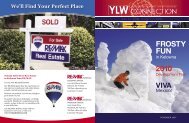

Create successful ePaper yourself
Turn your PDF publications into a flip-book with our unique Google optimized e-Paper software.
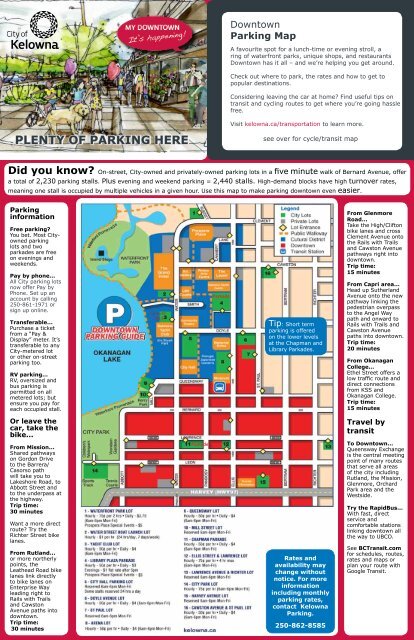
<strong>Downtown</strong><br />
<strong>Parking</strong> <strong>Map</strong><br />
A favourite spot for a lunch-time or evening stroll, a<br />
ring <strong>of</strong> waterfront parks, unique shops, and restaurants<br />
<strong>Downtown</strong> has it all – and we’re helping you get around.<br />
Check out where to park, the rates and how to get to<br />
popular destinations.<br />
Considering leaving the car at home? Find useful tips on<br />
transit and cycling routes to get where you’re going hassle<br />
free.<br />
Visit kelowna.ca/transportation to learn more.<br />
PLENTY OF PARKING HERE<br />
see over for cycle/transit map<br />
Did you know? On-street, <strong>City</strong>-owned and privately-owned parking lots in a five minute walk <strong>of</strong> Bernard Avenue, <strong>of</strong>fer<br />
a total <strong>of</strong> 2,230 parking stalls. Plus evening and weekend parking = 2,440 stalls. High-demand blocks have high turnover rates,<br />
meaning one stall is occupied by multiple vehicles in a given hour. Use this map to make parking downtown even easier.<br />
<strong>Parking</strong><br />
information<br />
Free parking?<br />
You bet. Most <strong>City</strong>owned<br />
parking<br />
lots and two<br />
parkades are free<br />
on evenings and<br />
weekends.<br />
Pay by phone...<br />
All <strong>City</strong> parking lots<br />
now <strong>of</strong>fer Pay by<br />
Phone. Set up an<br />
account by calling<br />
250-861-1971 or<br />
sign up online.<br />
Transferable...<br />
Purchase a ticket<br />
from a “Pay &<br />
Display” meter. It’s<br />
transferable to any<br />
<strong>City</strong>-metered lot<br />
or other on-street<br />
parking too.<br />
RV parking...<br />
RV, oversized and<br />
bus parking is<br />
permitted on all<br />
metered lots; but<br />
ensure you pay for<br />
each occupied stall.<br />
Or leave the<br />
car, take the<br />
bike...<br />
From Mission...<br />
Shared pathways<br />
on Gordon Drive<br />
to the Barrera/<br />
Casorso path<br />
will take you to<br />
Lakeshore Road, to<br />
Abbott Street and<br />
to the underpass at<br />
the highway.<br />
Trip time:<br />
30 minutes<br />
Want a more direct<br />
route? Try the<br />
Richter Street bike<br />
lanes.<br />
From Rutland...<br />
or more northerly<br />
points, the<br />
Leathead Road bike<br />
lanes link directly<br />
to bike lanes on<br />
Enterprise Way<br />
leading right to<br />
Rails with Trails<br />
and Cawston<br />
Avenue paths into<br />
downtown.<br />
Trip time:<br />
30 minutes<br />
Tip: Short term<br />
parking is <strong>of</strong>fered<br />
on the lower levels<br />
at the Chapman and<br />
Library Parkades.<br />
Rates and<br />
availability may<br />
change without<br />
notice. For more<br />
information<br />
including monthly<br />
parking rates,<br />
contact <strong>Kelowna</strong><br />
<strong>Parking</strong>.<br />
250-862-8585<br />
From Glenmore<br />
Road...<br />
Take the High/Clifton<br />
bike lanes and cross<br />
Clement Avenue onto<br />
the Rails with Trails<br />
and Cawston Avenue<br />
pathways right into<br />
downtown.<br />
Trip time:<br />
15 minutes<br />
From Capri area...<br />
Head up Sutherland<br />
Avenue onto the new<br />
pathway linking the<br />
pedestrian overpass<br />
to the Angel Way<br />
path and onward to<br />
Rails with Trails and<br />
Cawston Avenue<br />
paths into downtown.<br />
Trip time:<br />
20 minutes<br />
From Okanagan<br />
College...<br />
Ethel Street <strong>of</strong>fers a<br />
low traffic route and<br />
direct connections<br />
from KSS and<br />
Okanagan College.<br />
Trip time:<br />
15 minutes<br />
Travel by<br />
transit<br />
To <strong>Downtown</strong>...<br />
Queensway Exchange<br />
is the central meeting<br />
point <strong>of</strong> many routes<br />
that serve all areas<br />
<strong>of</strong> the city including<br />
Rutland, the Mission,<br />
Glenmore, Orchard<br />
Park area and the<br />
Westside.<br />
Try the RapidBus...<br />
With fast, direct<br />
service and<br />
comfortable stations<br />
linking downtown all<br />
the way to UBCO.<br />
See BCTransit.com<br />
for schedules, routes,<br />
rates and maps or<br />
plan your route with<br />
Google Transit.
<strong>Downtown</strong><br />
Cycle & Transit <strong>Map</strong><br />
<strong>Downtown</strong><br />
Cycle & Transit<br />
<strong>Map</strong><br />
see over for parking map<br />
smartTRIPS<br />
smartTRIPS is the Central Okanagan’s active transportation<br />
education program. The goal <strong>of</strong> smartTRIPS is to encourage<br />
all Central Okanagan residents to be healthy and active by<br />
reducing drive-alone trips. By biking, walking, riding transit,<br />
carpooling and other smart transportation options we benefit<br />
the community through better health, cleaner air and a<br />
healthier environment.<br />
Together we can improve the quality <strong>of</strong> life for everyone in<br />
the Central Okanagan.<br />
Visit smartTRIPS.ca to learn more.<br />
Cycling is not only great for your health but is one <strong>of</strong> the best ways to experience your community and stimulate your<br />
senses! Give it a try and see your downtown on two wheels. There are plenty <strong>of</strong> bike racks throughout downtown as well as<br />
bicycle lockers available for rent through <strong>Kelowna</strong> <strong>Parking</strong>. Call 250-862-8585.<br />
SUNSET DR<br />
Cycling routes<br />
BROADWAY AVE<br />
TRENCH PL<br />
Mount<br />
Royal<br />
Open<br />
Space<br />
Knox<br />
Mountain<br />
Park<br />
GLENMORE RD<br />
Transit routes<br />
CLEMENT AVE<br />
Okanagan Lake<br />
<strong>City</strong><br />
Park<br />
GUY ST<br />
Rotary<br />
Marsh<br />
Park<br />
Waterfront<br />
Park<br />
Mill<br />
Creek<br />
Linear<br />
Park<br />
ABBOTT ST<br />
SUNSET DR<br />
WATER ST<br />
<strong>City</strong><br />
Hall<br />
PANDOSY ST<br />
ELLIS ST<br />
<strong>Kelowna</strong><br />
General<br />
Hospital<br />
Recreation<br />
Avenue<br />
Park<br />
RICHTER ST<br />
RICHTER ST<br />
CADDER AVE<br />
CROWLEY AVE<br />
CLEMENT AVE<br />
Cawston<br />
Avenue<br />
Recreation<br />
Corridor<br />
HARVEY AVE<br />
WEDDELL PL<br />
ETHEL ST<br />
TRENCH PL<br />
GORDON DR<br />
BERNARD AVE<br />
GUISACHAN RD<br />
Lombardy<br />
Park<br />
SPRINGFIELD RD<br />
CLIFTON RD<br />
HIGH RD<br />
MOUNTAIN AVE<br />
Old<br />
Dr.<br />
Knox<br />
Middle<br />
School<br />
Parkinson<br />
Recreation<br />
Park<br />
Glenmore<br />
Elementary<br />
School<br />
SPALL RD<br />
GLENMORE DR<br />
<strong>Kelowna</strong><br />
Memorial<br />
Cemetery<br />
WATER ST<br />
SMITH AVE<br />
DOYLE AVE<br />
QUEENSWAY<br />
CANNERY LANE<br />
CAWSTON AVE<br />
ELLIS ST<br />
Queensway<br />
Exchange<br />
BERNARD AVE<br />
ST PAUL ST<br />
CORONATION AVE<br />
Tip: During peak<br />
travel times, Highway<br />
97 Express travels<br />
every 15 min. to and<br />
from <strong>Downtown</strong>’s<br />
Queensway Exchange.<br />
Trip time from<br />
Orchard Park: 10<br />
minutes<br />
BERTRAM ST<br />
FULLER AVE<br />
RICHTER ST<br />
ABBOTT ST<br />
0 200 400<br />
Meters<br />
ABBOTT ST<br />
PANDOSY ST<br />
CEDAR AVE<br />
RICHTER ST<br />
Shopping<br />
Centre<br />
RAYMER AVE<br />
<strong>Kelowna</strong><br />
Secondary<br />
School<br />
Okanagan<br />
College<br />
KLO<br />
Middle<br />
School<br />
BURTCH RD<br />
KLO RD<br />
BURTCH RD<br />
BYRNS RD<br />
Tip: A continuous<br />
<strong>of</strong>f road pathway<br />
from Dayton Street<br />
overpass to Rails with<br />
Trails will take you<br />
downtown.<br />
Trip time: 10<br />
minutes<br />
BENVOULIN RD<br />
ABBOTT ST<br />
PANDOSY ST<br />
LAWRENCE AVE<br />
LEON AVE<br />
HARVEY AVE<br />
<strong>Downtown</strong><br />
Cycling <strong>Map</strong> Legend<br />
200m = 3 minutes<br />
on street bike lanes<br />
paved lane on both sides, alongside vehicle<br />
traffic<br />
bike path<br />
<strong>of</strong>f road, paved pathway shared with<br />
pedestrians<br />
suggested bike route<br />
shared roadway with vehicles, no dedicated<br />
bike lane<br />
Ride aware.<br />
<strong>Downtown</strong><br />
Transit <strong>Map</strong> Legend<br />
Hwy 97 Express routes<br />
high frequency limited stop service (RapidBus line)<br />
#1 Lakeshore transit route<br />
high frequency route linking Mission Rec Exchange to<br />
<strong>Downtown</strong><br />
#11 South Rutland transit route<br />
high frequency route from Rutland to <strong>Downtown</strong><br />
#10 North Rutland transit route<br />
high frequency route from Rutland to <strong>Downtown</strong><br />
#7 Glenmore transit route<br />
high frequency route from Glenmore to <strong>Downtown</strong><br />
#9 Shopper shuttle transit route<br />
limited service route from <strong>Downtown</strong> to Orchard Park<br />
#2 North End shuttle loop<br />
community bus route travelling from Knox Mountain to<br />
<strong>Downtown</strong>