Appendix a Maps 1 5 - North West Leicestershire District Council
Appendix a Maps 1 5 - North West Leicestershire District Council
Appendix a Maps 1 5 - North West Leicestershire District Council

Create successful ePaper yourself
Turn your PDF publications into a flip-book with our unique Google optimized e-Paper software.
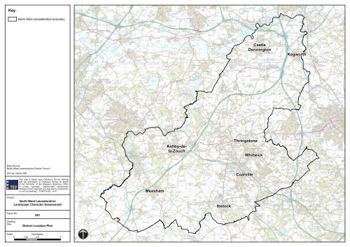
Key:<br />
<strong>North</strong> <strong>West</strong> <strong>Leicestershire</strong> boundary<br />
Castle<br />
Donnington<br />
Kegworth<br />
Ashby-dela-Zouch<br />
Thringstone<br />
Whitwick<br />
Data Source:<br />
<strong>North</strong> <strong>West</strong> <strong>Leicestershire</strong> <strong>District</strong> <strong>Council</strong><br />
TEP ref: G2233.005<br />
This map is based upon Ordnance Survey material<br />
with the permission of Ordnance Survey on behalf<br />
of the Controller of Her Majesty’s Stationery Office<br />
© Crown copyright. Unauthorised reproduction<br />
infringes Crown copyright and may lead to prosecution<br />
or civil proceedings. 0100019329 2010.<br />
Measham<br />
Coalville<br />
Project:<br />
<strong>North</strong> <strong>West</strong> <strong>Leicestershire</strong><br />
Landscape Character Assessment<br />
Ibstock<br />
Figure No:<br />
Drawing<br />
Title:<br />
001<br />
<strong>District</strong> Location Plan<br />
Scale:<br />
Kilometres<br />
0 1.25 2.5 5
Key:<br />
<strong>North</strong> <strong>West</strong> <strong>Leicestershire</strong> boundary<br />
Countryside Priority Areas<br />
Areas of Particularly<br />
Attractive Countryside<br />
Green Wedges<br />
Areas of Separation<br />
Sensitive Areas<br />
Note:<br />
Map only shows sensitive area relevant<br />
to the six settlement study areas.<br />
Data Source:<br />
Indicative boundaries digitised from local plan<br />
TEP ref: G2233.021<br />
This map is based upon Ordnance Survey material<br />
with the permission of Ordnance Survey on behalf<br />
of the Controller of Her Majesty’s Stationery Office<br />
© Crown copyright. Unauthorised reproduction<br />
infringes Crown copyright and may lead to prosecution<br />
or civil proceedings. 0100019329 2010.<br />
Project:<br />
<strong>North</strong> <strong>West</strong> <strong>Leicestershire</strong><br />
Landscape Character Assessment<br />
Figure No:<br />
Drawing<br />
Title:<br />
002<br />
Landscape Designations<br />
Scale:<br />
Kilometres<br />
0 1.25 2.5 5
Key:<br />
<strong>North</strong> <strong>West</strong> <strong>Leicestershire</strong> boundary<br />
National Landscape Character<br />
Charnwood<br />
<strong>Leicestershire</strong> Vales<br />
<strong>Leicestershire</strong> and<br />
Nottinghamshire Wolds<br />
<strong>Leicestershire</strong> and<br />
South Derbyshire Coalfield<br />
Mease/Sence Lowlands<br />
Melbourne Parklands<br />
Needwood and South<br />
Derbyshire Claylands<br />
Trent Valley Washlands<br />
Trent and Belvoir Vales<br />
Data Source:<br />
© Natural England [2010], reproduced with the<br />
permission of Natural England,<br />
http://www.naturalengland.org.uk/copyright/.<br />
TEP ref: G2233.006<br />
This map is based upon Ordnance Survey material<br />
with the permission of Ordnance Survey on behalf<br />
of the Controller of Her Majesty’s Stationery Office<br />
© Crown copyright. Unauthorised reproduction<br />
infringes Crown copyright and may lead to prosecution<br />
or civil proceedings. 0100019329 2010.<br />
Project:<br />
<strong>North</strong> <strong>West</strong> <strong>Leicestershire</strong><br />
Landscape Character Assessment<br />
Figure No:<br />
Drawing<br />
Title:<br />
003<br />
National Landscape<br />
Character Areas<br />
Scale:<br />
Kilometres<br />
0 1.25 2.5 5
Key:<br />
<strong>North</strong> <strong>West</strong> <strong>Leicestershire</strong> boundary<br />
Regional Character Assessment<br />
Clay Wolds<br />
Floodplain Valleys<br />
Forested Ancient Hills<br />
Settled Coalfield Farmlands<br />
Unwooded Vales<br />
Urban Areas<br />
Village Farmlands<br />
Wooded Village Farmlands<br />
Data Source:<br />
© Natural England [2010], reproduced with the<br />
permission of Natural England,<br />
http://www.naturalengland.org.uk/copyright/.<br />
TEP ref: G2233.009<br />
This map is based upon Ordnance Survey material<br />
with the permission of Ordnance Survey on behalf<br />
of the Controller of Her Majesty’s Stationery Office<br />
© Crown copyright. Unauthorised reproduction<br />
infringes Crown copyright and may lead to prosecution<br />
or civil proceedings. 0100019329 2010.<br />
Project:<br />
<strong>North</strong> <strong>West</strong> <strong>Leicestershire</strong><br />
Landscape Character Assessment<br />
Figure No:<br />
Drawing<br />
Title:<br />
004<br />
East Midlands Regional<br />
Character Areas<br />
Scale:<br />
Kilometres<br />
0 1.25 2.5 5
Key:<br />
<strong>North</strong> <strong>West</strong> <strong>Leicestershire</strong> boundary<br />
County Character Assessment<br />
Charnwood Forest<br />
Langley Lowlands<br />
Mease/Sence Lowlands<br />
The Coalfield<br />
Trent Valley<br />
Data Source:<br />
Indicative character areas as shown in the Leicester,<br />
<strong>Leicestershire</strong> and Rutland Landscape and Woodland<br />
Strategy, <strong>Leicestershire</strong> County <strong>Council</strong> 2001.<br />
TEP ref: G2233.010<br />
This map is based upon Ordnance Survey material<br />
with the permission of Ordnance Survey on behalf<br />
of the Controller of Her Majesty’s Stationery Office<br />
© Crown copyright. Unauthorised reproduction<br />
infringes Crown copyright and may lead to prosecution<br />
or civil proceedings. 0100019329 2010.<br />
Project:<br />
<strong>North</strong> <strong>West</strong> <strong>Leicestershire</strong><br />
Landscape Character Assessment<br />
Figure No:<br />
Drawing<br />
Title:<br />
005<br />
County Character Areas<br />
Scale:<br />
Kilometres<br />
0 1.25 2.5 5