Evacuation Route Reference Map - Ward 3 - Homeland Security and ...
Evacuation Route Reference Map - Ward 3 - Homeland Security and ...
Evacuation Route Reference Map - Ward 3 - Homeland Security and ...

Create successful ePaper yourself
Turn your PDF publications into a flip-book with our unique Google optimized e-Paper software.
lue<br />
Medical Center<br />
MONTGOMERY<br />
COUNTY<br />
Silver Spring<br />
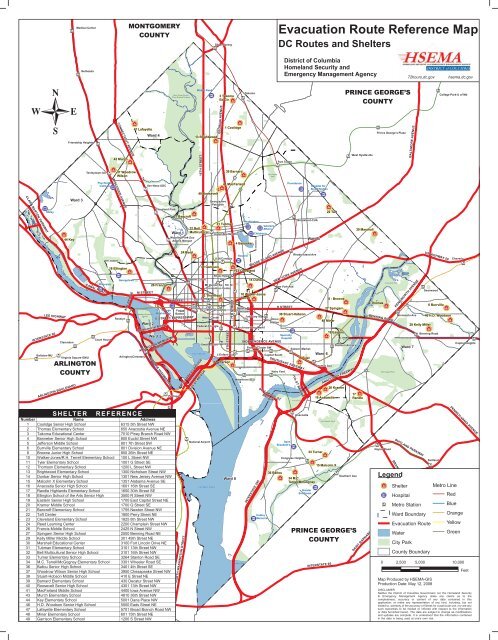
<strong>Evacuation</strong> <strong>Route</strong> <strong>Reference</strong> <strong>Map</strong><br />
DC <strong>Route</strong>s <strong>and</strong> Shelters<br />
Bethesda<br />
District of Columbia<br />
<strong>Homel<strong>and</strong></strong> <strong>Security</strong> <strong>and</strong><br />
Emergency Management Agency<br />
72hours.dc.gov<br />
hsema.dc.gov<br />
Rock Creek Park &<br />
Piney Branch Parkway<br />
Walter Reed<br />
3 Takoma<br />
Ed Ctr<br />
Takoma<br />
PRINCE GEORGE’S<br />
COUNTY<br />
College Park-U of Md<br />
Friendship Heights<br />
Tenleytown-AU<br />
CONNECTICUT AVENUE<br />
43 Murch<br />
37 Woodrow<br />
Wilson<br />
47 Lafayette<br />
<strong>Ward</strong> 4<br />
13 Brightwood<br />
16TH STREET<br />
GEORGIA AVENUE<br />
1 Coolidge<br />
39 Barnard<br />
Fort Totten<br />
Park<br />
Fort Totten<br />
West Hyattsville<br />
Prince George’s Plaza<br />
BALTIMORE AVENUE<br />
Psychiatric<br />
Institute<br />
WISCONSIN AVENUE<br />
Van Ness-UDC<br />
40 Roosevelt<br />
41 MacFarl<strong>and</strong><br />
Providence<br />
Hospital for<br />
Sick Children<br />
CLARA BARTON PARKWAY<br />
<strong>Ward</strong> 3<br />
Georgia Ave<br />
Petworth<br />
Sibley<br />
44 Key<br />
Clevel<strong>and</strong> Park<br />
21 Bancroft<br />
<strong>Ward</strong> 1<br />
Woodley Park-Zoo<br />
Adams Morgan<br />
32 Bell<br />
Multicultural<br />
31 Tubman<br />
Columbia Heights<br />
Washington<br />
Veterans<br />
Affairs<br />
Children’s<br />
4 Banneker<br />
Brookl<strong>and</strong>-CUA<br />
<strong>Ward</strong> 5<br />
22 Taft<br />
30 Marshall<br />
LEE HIGHWAY<br />
INTERSTATE 66<br />
Ballston-MU<br />
Clarendon<br />
Virginia Square-GMU<br />
ARLINGTON<br />
COUNTY<br />
ARLINGTON BOULEVARD<br />
CANAL ROAD<br />
Riverside<br />
Court House<br />
18 Ellington<br />
Georgetown<br />
Rosslyn<br />
KEY BRIDGE<br />
Arlington|Cemetery<br />
M STREET<br />
Theodore Roosevelt<br />
Isl<strong>and</strong><br />
<strong>Ward</strong> 2<br />
26 Francis<br />
George<br />
Washington<br />
T.R. Memorial Bridge<br />
<strong>Ward</strong> 2<br />
ARLINGTON MEMORIAL<br />
BRIDGE<br />
K STREET<br />
Foggy<br />
Bottom<br />
24 Reed<br />
E STREET EXPRESSWAY<br />
VIRGINIA HIGHWAY 110<br />
Pentagon<br />
Dupont Circle<br />
Farragut<br />
West<br />
14TH ST BRIDGE<br />
49 Garrison<br />
The Mall<br />
U St/Cardozo<br />
Shaw-Howard<br />
Univ<br />
Mt Vernon Sq - 7th St<br />
Convention Center<br />
East Potomac Park<br />
Howard<br />
23 Clevel<strong>and</strong><br />
14 Dunbar<br />
12 Thomson 10 Walker-Jones<br />
Farragut<br />
Terrell<br />
North<br />
McPherson Sq<br />
Metro Center<br />
Federal Triangle<br />
TIDAL BASIN<br />
ROCHAMBEAU BRIDGE<br />
Smithsonian<br />
9TH STREET<br />
5 Jefferson<br />
7TH STREET<br />
L’Enfant Plaza<br />
Gallery Pl<br />
Chinatown<br />
Judiciary Sq<br />
Archives-Navy Mem’l<br />
Waterfront SEU<br />
RHODE ISLAND AVENUE<br />
INDEPENDENCE AVENUE<br />
Federal Center SW<br />
SO CAPITOL ST<br />
BRIDGE<br />
38 Stuart-Hobson<br />
Union<br />
Station<br />
Capitol South<br />
NEW YORK AVENUE<br />
New York Ave<br />
H STREET<br />
Specialty<br />
Hospital<br />
Eastern Market<br />
SOUTHEAST FREEWAY<br />
Navy Yard<br />
ANACOSTIA RIVER<br />
Rhode Isl<strong>and</strong> Ave<br />
11th ST BRIDGE<br />
Anacostia Park<br />
11 Tyler<br />
<strong>Ward</strong> 6<br />
8 - Browne<br />
27 Spingarn<br />
48 Miner<br />
Potomac Ave<br />
16 Anacostia<br />
19 Eastern<br />
20 Kramer<br />
Anacostia Park<br />
Stadium Armory<br />
ANACOSTIA FREEWAY<br />
17<br />
R<strong>and</strong>le<br />
Anacostia Park<br />
2 Thomas<br />
Minnesota Ave<br />
BENNING ROAD<br />
Fort Dupont Park<br />
KENILWORTH AVENUE<br />
US HIGHWAY 50<br />
29 Kelly Miller<br />
Benning Road<br />
<strong>Ward</strong> 7<br />
Cheverly<br />
Deanwood<br />
6 Burrville<br />
46 H.D. Woodson<br />
Capitol Heights<br />
SHELTER<br />
COLUMBIA PIKE<br />
ALEXANDRIA (CITY)<br />
FAIRFAX<br />
REFERENCE<br />
Number Name Address<br />
1 Coolidge Senior High School 6315 5th Street NW<br />
2 Thomas Elementary School 650 Anacostia Avenue NE<br />
3 Takoma Educational Center 7010 Piney Branch Road NW<br />
4 Banneker Senior High School 800 Euclid Street NW<br />
5 Jefferson Middle School 801 7th Street SW<br />
6 Burrville Elementary School 801 Division Avenue NE<br />
8 Browne Junior High School 850 26th Street NE<br />
10 Walker-Jones/R.H. Terrell Elementary School 100 L Street NW<br />
11 Tyler Elementary School 1001 G Street SE<br />
12 Thomson Elementary School 1200 L Street NW<br />
13 Brightwood Elementary School 1300 Nicholson Street NW<br />
14 Dunbar Senior High School 1301 New Jersey Avenue NW<br />
15 Malcolm X Elementary School 1351 Alabama Avenue SE<br />
16 Anacostia Senior High School 1601 16th Street SE<br />
17 R<strong>and</strong>le Highl<strong>and</strong>s Elementary School 1650 30th Street SE<br />
18 Ellington School of the Arts Senior High 3500 R Street NW<br />
19 Eastern Senior High School 1700 East Capitol Street NE<br />
20 Kramer Middle School 1700 Q Street SE<br />
21 Bancroft Elementary School 1755 Newton Street NW<br />
22 Taft Center 1800 Perry Street NE<br />
23 Clevel<strong>and</strong> Elementary School 1825 8th Street NW<br />
24 Reed Learning Center 2200 Champlain Street NW<br />
26 Francis Middle School 2425 N Street NW<br />
27 Spingarn Senior High School 2500 Benning Road NE<br />
INTERSTATE 395<br />
29 Kelly Miller Middle School 301 49th Street NE<br />
30 Marshall Educational Center 3100 Fort Lincoln Drive NE<br />
31 Tubman Elementary School 3101 13th Street NW<br />
32 Bell Multicultural Senior High School 3101 16th Street NW<br />
33 Turner Elementary School 3264 Stanton Road SE<br />
34 M.C. Terrell/McGogney Elementary School 3301 Wheeler Road SE<br />
36 Ballou Senior High School 3401 4th Street SE<br />
37 Woodrow Wilson Senior High School 3950 Chesapeake Street NW<br />
38 Stuart-Hobson Middle School 410 E Street NE<br />
39 Barnard Elementary School 430 Decatur Street NW<br />
40 Roosevelt Senior High School 4301 13th Street NW<br />
41 MacFarl<strong>and</strong> Middle School 4400 Iowa Avenue NW<br />
43 Murch Elementary School 4810 36th Street NW<br />
44 Key Elementary School 5001 Dana Place NW<br />
46 H.D. Woodson Senior High School 5500 Eads Street NE<br />
47 Lafayette Elementary School 5701 Broad Branch Road NW<br />
48 Miner Elementary School 601 15th Street NE<br />
49 Garrison Elementary School 1200 S Street NW<br />
RICHMOND HIGHWAY<br />
JEFFERSON DAVIS HIGHWAY<br />
NORTH WASHINGTON STREET<br />
National Airport<br />
POTOMAC RIVER<br />
<strong>Ward</strong> 8<br />
OXON RUN<br />
INTERSTATE 295<br />
Hadley<br />
Memorial<br />
36 Ballou<br />
Saint<br />
Elizabeth’s<br />
Anacostia<br />
Congress Heights<br />
Greater<br />
Southeast<br />
33 Turner<br />
34 M.C.<br />
Terrell/McGogney<br />
Fort Stanton Park<br />
15 Malcolm X<br />
Southern Ave<br />
PRINCE GEORGE’S<br />
COUNTY<br />
INTERSTATE 95<br />
SAINT BARNABUS ROAD<br />
Naylor Road<br />
SUITLAND PARKWAY<br />
BRANCH AVENUE<br />
Legend<br />
Shelter<br />
Hospital<br />
Metro Station<br />
<strong>Ward</strong> Boundary<br />
<strong>Evacuation</strong> <strong>Route</strong><br />
Water<br />
City Park<br />
County Boundary<br />
<strong>Map</strong> Produced by HSEMA-GIS<br />
Production Date: May 12, 2008<br />
Suitl<strong>and</strong><br />
Metro Line<br />
PENNSYLVANIA AVENUE<br />
Red<br />
Blue<br />
Orange<br />
Yellow<br />
Green<br />
0 2,500 5,000 10,000<br />
Feet<br />
DISCLAIMER<br />
Neither the District of Columbia Government nor the <strong>Homel<strong>and</strong></strong> <strong>Security</strong><br />
& Emergency Management Agency make any claims as to the<br />
completeness, accuracy or content of any data contained in this<br />
application; or make any representation of any kind, including, but not<br />
limited to, warranty of the accuracy or fitness for a particular use, nor are any<br />
such warranties to be implied or inferred with respect to the information<br />
or data furnished herein. The data are subject to change as modifications<br />
<strong>and</strong> updates are complete. It is understood that the information contained<br />
in the data is being used at one’s own risk.
I ST<br />
I ST<br />
M ST<br />
P ST<br />
Q ST<br />
Hospital<br />
FAIRFAX<br />
PRINCE<br />
GEORGE’S<br />
County Boundary<br />
Green Line<br />
Collector; Local<br />
ALEXANDRIA<br />
Police Station<br />
Metro Station<br />
<strong>Ward</strong> Boundary<br />
Yellow Line<br />
Minor Arterial<br />
Fire Station<br />
Recreation Center<br />
Water<br />
Orange Line<br />
Principal Arterial<br />
ARLINGTON<br />
Transfer Point<br />
City Park<br />
Blue Line<br />
Expressway<br />
Shelter<br />
VIRGINIA HIGHWAY 110<br />
Public School<br />
<strong>Evacuation</strong> <strong>Route</strong><br />
Red Line<br />
Streets<br />
DISTRICT<br />
OF<br />
COLUMBIA<br />
Legend<br />
MONTGOMERY<br />
PRINCE<br />
GEORGE’S<br />
Number Name Address<br />
37 Woodrow Wilson Senior High School 3950 Chesapeake Street NW<br />
43 Murch Elementary School 4810 36th Street NW<br />
44 Key Elementary School 5001 Dana Place NW<br />
ARL<br />
Feet<br />
ARLINGTON MEMORIAL BRG<br />
INTERSTATE 66<br />
INGTON BOULEVARD<br />
0 750 1,500 3,000<br />
SHELTER REFERENCE<br />
District of Columbia<br />
<strong>Homel<strong>and</strong></strong> <strong>Security</strong> <strong>and</strong><br />
Emergency Management Agency<br />
72hours.dc.gov hsema.dc.gov<br />
CONSTITUTION AVE<br />
23RD ST<br />
E ST<br />
L EE HIGHWAY<br />
<strong>Ward</strong> 3<br />
<strong>Evacuation</strong> <strong>Route</strong> <strong>Reference</strong> <strong>Map</strong><br />
<strong>Ward</strong> 2<br />
20TH ST<br />
POTOMAC RIVER<br />
K ST<br />
CANAL R D<br />
FRANCIS SCOTT KEY BRG<br />
VIRGINIA AVE<br />
23RD ST<br />
H ST<br />
I ST<br />
I ST<br />
GEORGE WASHINGTON MEMORIAL PARKWAY<br />
23RD ST<br />
Riverside<br />
Hardy<br />
ROCK CREEK & POTOMAC PKWY<br />
K ST<br />
L ST<br />
M ST<br />
CANAL ROAD<br />
FOXHALL RD<br />
19TH ST<br />
WISCONSIN AVENUE<br />
26<br />
22ND ST<br />
18TH ST<br />
ARLINGTON<br />
COUNTY<br />
MASSACHUSETTS AVE<br />
Q ST<br />
Q ST<br />
RESERVOIR RD<br />
R ST<br />
18<br />
CANAL RD<br />
MACARTHUR BOULE VARD<br />
FLORIDA AVE<br />
CONNECTICUT AVE<br />
24<br />
Guy Mason<br />
TUNLAW RD<br />
Oyster-Adams<br />
CALVERT ST<br />
Stoddert ES<br />
COLUMBIA RD<br />
Palisades<br />
MASSACHUSETTS AVE<br />
MACARTHUR BLVD<br />
Woodley Park-Zoo/<br />
Adams Morgan<br />
CLEVELAND AVE<br />
Key ES<br />
44<br />
<strong>Ward</strong> 1<br />
NEW MEXICO AVE<br />
MASSACHUSETTS AVE<br />
IRVING ST<br />
CHAIN BRG<br />
ARIZONA AVE<br />
34TH ST<br />
ADAMS MILL RD<br />
LOUGHBORO RD<br />
Eaton ES<br />
KLINGLE RD<br />
PARK RD<br />
<strong>Ward</strong> 3<br />
Mann ES<br />
Macomb<br />
Clevel<strong>and</strong> Park<br />
PORTER ST<br />
CLAR A BARTON PARKWAY<br />
LOUGHBORO RD<br />
PINEY BRANCH PKWY<br />
21<br />
Sibley<br />
Memorial<br />
WISCONSIN AVE<br />
PORTER ST<br />
AU<br />
DALECARLIA PKWY<br />
MASSACHUSETTS AVE<br />
NEBRASKA AVE<br />
Hearst ES<br />
TILDEN ST<br />
Van Ness-UDC<br />
Friendship<br />
Psychiatric Institute<br />
of Washington<br />
CONNECTICUT AVENUE<br />
Janney ES<br />
Tenleytown-AU<br />
Woodrow Wilson SH<br />
37<br />
RIVER RD<br />
Murch ES<br />
WESTERN AVE<br />
WISCONSIN AVE<br />
Deal JH<br />
NEBRASKA AVE<br />
43<br />
CONNECTICUT AVE<br />
RENO RD<br />
Friendship<br />
Heights<br />
NEBRASKA AVE<br />
MONTGOMERY<br />
COUNTY<br />
MILITARY RD<br />
MILITARY RD<br />
Chevy Chase R.C.<br />
BEACH DR<br />
Lafayette ES<br />
Chevy Chase C.C.<br />
47<br />
<strong>Ward</strong> 4<br />
SHELTER AND EVACUATION GUIDE<br />
SHELTER<br />
Emergency Kit<br />
Store the following items in an easy-to-carry container<br />
such as a backpack or duffle bag<br />
1. Water - At least a three-day supply per person.<br />
2. Food - Three-to-five-day supply of non-perishable<br />
ready-to-eat meals <strong>and</strong> a manual can opener.<br />
3. Medication / First Aid Kit - Prescription medications<br />
for at least a week. Note expiration date.<br />
4. Sanitation - Toilet paper, paper towels, antibacterial<br />
soap <strong>and</strong> wipes, sanitary <strong>and</strong> personal hygiene<br />
products.<br />
5. Clothing - One change of clothes per person, comfortable<br />
shoes, <strong>and</strong> rain wear.<br />
6. Communication - Portable radio, flashlight, <strong>and</strong><br />
extra batteries.<br />
7. Bedding - Sleeping bag <strong>and</strong> essential bedding.<br />
Pet <strong>Evacuation</strong><br />
If you must evacuate, take your pets with you if possible.<br />
However, if you are going to a public shelter, it is important to<br />
underst<strong>and</strong> that animals may not be allowed inside. Plan in<br />
advance for shelter alternatives that will work for both you <strong>and</strong><br />
your pets.<br />
Prepare a Pet Emergency Kit<br />
Bowl, food, medication, plastic bags, paper towels.<br />
ID collar, rabies tags, leash, carrier, or cage.<br />
Veterinary records.<br />
A three-day supply of food <strong>and</strong> water.<br />
Be familiar with your children’s emergency pick- up<br />
locations.<br />
Ask how the facilities will communicate with families<br />
during an evacuation.<br />
Returning Home<br />
Emergency officials will determine when it is safe for residents<br />
to move back into their homes. Be assured this notification will<br />
happen as soon as possible.<br />
Return notices will be announced through the media<br />
as well as at road blocks, safety zones <strong>and</strong> shelters.<br />
http://hsema.dc.gov<br />
http://72hours.dc.gov<br />
Important District Telephone Numbers<br />
Police <strong>and</strong> Fire Emergency<br />
Calls that require police, fire or emergenc<br />
medical services to respond<br />
The Mayor’s Citywide Call Center<br />
Calls for city services <strong>and</strong> information<br />
DC <strong>Homel<strong>and</strong></strong> <strong>Security</strong> <strong>and</strong> Emergency<br />
Management Agency (24-hour)<br />
For the hearing impaired<br />
911<br />
311<br />
(202) 727-6161<br />
(202) 730-0488<br />
AND<br />
EVACUATION<br />
GUIDE<br />
DISTRICT OF COLUMBIA<br />
WARD [3]<br />
Special Needs<br />
If you have a family member with special needs, or a neighbor<br />
who lives alone, find out how to help them get necessary care<br />
during an emergency.<br />
Wear medical alert tags <strong>and</strong> bracelets to identify<br />
your disability.<br />
Keep writing materials on h<strong>and</strong> if you have speech,<br />
language, or hearing disabilities.<br />
Department of Mental Health Access HelpLine<br />
American Red Cross, National Capital Chapter<br />
Verizon (phone)<br />
PEPCO (electric)<br />
Customer service<br />
Power outages<br />
Life-threatening emergencies<br />
Poison Control Center<br />
(888) 793-4357<br />
(202) 728-6401<br />
(800) 275-2355<br />
(202) 833-7500<br />
(877) PEPCO-62<br />
(202) 872-3432<br />
(800) 222-1222<br />
<strong>Evacuation</strong> routes are identified by the stars<br />
<strong>and</strong> bars symbol on street signs.<br />
Buddy System<br />
Working with neighbors in an emergency can save lives <strong>and</strong><br />
property. Meet with your community members to plan how you<br />
can help your neighbors <strong>and</strong> those with special needs, such<br />
as people with disabilities <strong>and</strong> elderly persons.<br />
Washington Gas<br />
Customer service<br />
Natural Gas Emergency Number<br />
DC Water <strong>and</strong> Sewer Authority<br />
Water <strong>and</strong> Sewer Emergency Number<br />
DC Department of Health<br />
(202) 624-6049<br />
(703) 750-1400<br />
(202) 787-2000<br />
(202) 612-3400<br />
(202) 671-5000<br />
http://hsema.dc.gov http://72hours.dc.gov<br />
School, Daycare, <strong>and</strong> Recreation Centers<br />
Parents should learn their children’s school <strong>and</strong>/or daycare<br />
providers’ emergency plans.<br />
West Nile Virus Call Center<br />
(Department of Health)<br />
DC Animal Control (24-hour)<br />
(202) 535-2323<br />
(202) 576-6664<br />
Government of the District of Columbia<br />
Vincent C. Gray, Mayor<br />
Planning for what to do before an emergency is an<br />
important part of being prepared.<br />
This brochure will help you:<br />
1. Get Informed<br />
2. Make a Plan<br />
3. Make an Emergency Kit<br />
4. Be Aware<br />
<strong>Evacuation</strong> Notification<br />
In an emergency, officials will notify residents <strong>and</strong> visi<br />
tors of potential hazards, incidents, events, <strong>and</strong> whether<br />
it is safest to evacuate or shelter in place. Official infor<br />
mation sources include the following:<br />
The Emergency Information Center (EIC) Website<br />
http://72hours.dc.gov<br />
Sign up for emergency text messages on your cell<br />
phone, e-mail, pager, or fax at www.Alert.dc.gov.<br />
DC online 24/7 emergency information source.<br />
DC Emergency Voice Alert, or “Reverse 911”<br />
Voice messaging system that allows emergency<br />
managers to notify citizens during an emergency.<br />
Citizens are automatically enrolled.<br />
Protection Options:<br />
Shelter in Place or Evacuate?<br />
Whenever possible, you should follow instructions from emergency<br />
personnel in deciding whether to shelter in place or<br />
evacuate. In many cases, it is safest to remain indoors.<br />
Shelter in Place<br />
Stay inside a safe building—your house, workplace,<br />
school, or other building—or enter a nearby building<br />
<strong>and</strong> seek cover.<br />
Shelter in a room with the fewest doors <strong>and</strong>/or windows.<br />
Seal doors, windows, <strong>and</strong> fireplaces <strong>and</strong> turn o f<br />
ventilation <strong>and</strong> hot air heating systems.<br />
Public Assembly Points (Safe Havens)<br />
Temporary holding area for small groups providing a<br />
safe haven until shelter location can be established.<br />
Fire stations <strong>and</strong> libraries are community safe havens.<br />
Potential <strong>Ward</strong> 3 Shelter Locations<br />
These shelters have been pre-identified, but may not be used<br />
in every event. Check with local officials <strong>and</strong> news sources to<br />
find the best place to go if you are seeking shelte .<br />
Woodrow Wilson Senior<br />
High School<br />
3950 Chesapeake Street NW<br />
(202) 282-0120<br />
Also, during an emergency situation, the critical intersections<br />
on the evacuation routes within DC will be staffed by uniformed<br />
law enforcement officers. The direction of the evacuation<br />
will be dictated by the incident in relation to your ward,<br />
home, or business. When evacuation is ordered, occupants<br />
of the city have a number of options such as walking out <strong>and</strong><br />
using private or public transportation.<br />
Walk Out<br />
Walking is a effective means of evacuating.<br />
Keep a good pair of walking shoes at your school or<br />
place of business.<br />
Stay on the sidewalk. Do not block evacuation<br />
routes or secondary arteries.<br />
Private Transportation<br />
Identify the closest evacuation route to you.<br />
Take your Emergency Kit with you.<br />
Public Transportation<br />
Transit providers such as the Washington Metropolitan<br />
Area Transit Authority (WMATA) <strong>and</strong> others will<br />
have service running on normal schedules wherever<br />
possible. Check the official information sources to<br />
find out how the public transportation system may<br />
be affected.<br />
<strong>Ward</strong> 3 <strong>Evacuation</strong> <strong>Route</strong>s<br />
Residents should be familiar with all evacuation routes<br />
that lead in <strong>and</strong> out of their specific wards. DC event<br />
emergency routes can be identified by green signs that<br />
read “To Downtown” <strong>and</strong> “To Interstate.”<br />
DC Emergency Alert System<br />
Partnership with local radio stations as part of the<br />
emergency alert system.<br />
Listen to these channels for emergency information.<br />
Murch Elementary<br />
School<br />
4810 36th Street NW<br />
(202) 282-0130<br />
Major <strong>Evacuation</strong> <strong>Route</strong>s in <strong>Ward</strong> 3<br />
CLARA BARTON PARKWAY<br />
CONNECTICUT AVENUE<br />
WTOP 103.5 FM WKYS 93.9 FM<br />
WMAL 630 AM WJZW 105.9 FM<br />
WPRS 104.1 FM WPGC 95.5 FM<br />
Key Elementary School 5001 Dana Place NW<br />
(202) 282-3800<br />
CHAIN BRIDGE<br />
FOXHALL ROAD<br />
CHEVY CHASE CIRCLE<br />
Note: If you are unable to receive Alert DC notifica<br />
tions, please contact 311, the Mayor’s Citywide Call<br />
Center.<br />
Or please visit: http://hsema.dc.gov<br />
http://72hours.dc.gov<br />
<strong>Evacuation</strong><br />
There are 19 primary evacuation routes out of the city that<br />
are marked with DC flags in the right-h<strong>and</strong> corner of the street<br />
sign. Pennsylvania Avenue will be the north/south dividing line<br />
during an evacuation. No vehicles will be permitted to cross<br />
Pennsylvania Avenue during an evacuation.<br />
WISCONSIN AVENUE<br />
CANAL ROAD<br />
MACARTHUR BOULEVARD<br />
SHELTER AND EVACUATION GUIDE