Improvements in iMAPS Update - Wake County Government
Improvements in iMAPS Update - Wake County Government
Improvements in iMAPS Update - Wake County Government

Create successful ePaper yourself
Turn your PDF publications into a flip-book with our unique Google optimized e-Paper software.
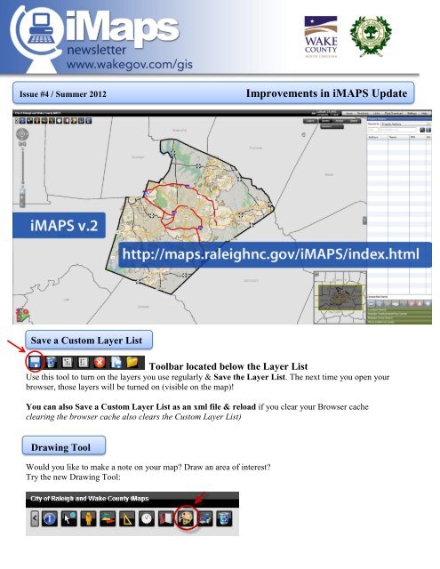
Issue #4 / Summer 2012<br />
<strong>Improvements</strong> <strong>in</strong> <strong>iMAPS</strong> <strong>Update</strong><br />
Save a Custom Layer List<br />
Toolbar located below the Layer List<br />
Use this tool to turn on the layers you use regularly & Save the Layer List. The next time you open your<br />
browser, those layers will be turned on (visible on the map)!<br />
You can also Save a Custom Layer List as an xml file & reload if you clear your Browser cache<br />
clear<strong>in</strong>g the browser cache also clears the Custom Layer List)<br />
Draw<strong>in</strong>g Tool<br />
Would you like to make a note on your map? Draw an area of <strong>in</strong>terest?<br />
Try the new Draw<strong>in</strong>g Tool:
Legend:<br />
The Legend shows the different colors and symbols on the map with a brief description of their mean<strong>in</strong>g<br />
Pictometry (Bird’s Eye) Image<br />
Pictometry images are available for <strong>Wake</strong> <strong>County</strong> <strong>in</strong> this<br />
updated version of <strong>iMAPS</strong>. These are oblique images<br />
(most are captured at a 40 degree angle). These images<br />
allow the user to see different views of a build<strong>in</strong>g or area.<br />
For full screen mode click on the<br />
monitor icon at the bottom<br />
FAQ<br />
How challeng<strong>in</strong>g will it be to learn the new<br />
version?<br />
We left the look & feel of the new version similar<br />
to the previous version to make the transition<br />
easier. The new version <strong>in</strong>cludes improvements<br />
based on customer feedback and a few new<br />
tools.<br />
Do you have any plans to release a version of<br />
<strong>iMAPS</strong> for iPhone, iPad and Android?<br />
Yes. Mobile versions of <strong>iMAPS</strong> are <strong>in</strong><br />
development for iPhone/iPad and Android.<br />
If you need help or have feedback:<br />
<strong>iMAPS</strong>Helpdesk@wakegov.com<br />
Pan & Zoom Tools consolidated<br />
To zoom <strong>in</strong> and out:<br />
* Move the vertical slider up and down or<br />
* Use the tools below the slider & draw a box<br />
on the map or<br />
* Use the mouse wheel (forward &back)<br />
To Pan:<br />
* When you first open <strong>iMAPS</strong> – Pan is the<br />
default tool; you can pan the map without<br />
select<strong>in</strong>g a tool<br />
* Once you have used another tool (such as zoom<br />
<strong>in</strong>), if you want to pan, click on the Pan Tool<br />
(below the vertical slider bar) and then drag the<br />
map<br />
Why did we change these tools?<br />
Mov<strong>in</strong>g these tools will help customers who have<br />
their monitors set on a low resolution (large<br />
icons). The change creates more space for the<br />
Map Tools.