Appendix 13.2 - LMDB Correspondence - Partnerships for ...
Appendix 13.2 - LMDB Correspondence - Partnerships for ...
Appendix 13.2 - LMDB Correspondence - Partnerships for ...

Create successful ePaper yourself
Turn your PDF publications into a flip-book with our unique Google optimized e-Paper software.
Louth Canal Wind Energy Development<br />
<strong>Appendix</strong> <strong>13.2</strong> – Lindsey Marsh Drainage Board<br />
<strong>Correspondence</strong><br />
March 2012<br />
<strong>Appendix</strong> <strong>13.2</strong> – Lindsey Marsh Drainage Board <strong>Correspondence</strong><br />
Copyright <strong>Partnerships</strong> <strong>for</strong> Renewables Development Co. Ltd 2012 ©
Sarah Rab<br />
From:<br />
Martin Mitchell [Martin.Mitchell@lmdb.co.uk]<br />
Sent: 06 July 2011 09:34<br />
To:<br />
Sarah Rab<br />
Cc:<br />
David Sisson; Andrew Dale<br />
Subject:<br />
RE: In<strong>for</strong>mation request: flood risk in<strong>for</strong>mation <strong>for</strong> Louth Canal and Old Fleet Drain<br />
Attachments:<br />
2007 flooding viewed from thoresby Bridge.pdf; 110706 100yr model water levels<br />
Thoresby catchment.pdf; 110706 Thoresby PS Details.pdf<br />
Sarah<br />
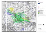
In June and July 2007 there was extensive flooding of land in our Thoresby Bridge Pumping Station Catchment. The<br />
water level reached approximately +2.05m ODN at the Pumping Station. There was also flooding in North Cotes in<br />
2007 and 1979. There is a syphon under the Louth Canal connecting the east and west parts of the catchment to the<br />
PS.<br />
Prior to the installation of the Pumping Station at Thorsby Bridge in 1969 all water from the catchment flowed east<br />
down the old fleet to outfall approximately 100m u/s of the Louth canal outfall sluice. The old fleet was blocked off<br />
in North Cotes when the PS was built.<br />
The system has been modelled by Aecom using ISIS and the 100 year level at the PS is +1.87. However the model did<br />
not include any overtopping from the EA main rivers and I believe underestimated the flow from blow holes which<br />
are prevalent in the catchment. We have recently carried out a flood defence scheme <strong>for</strong> North Cotes – a flood<br />
defence bank to a 100 year design water level of +2.1m ODN. We have also raised all equipment at our Thoresby<br />
Bridge PS by 500mm to approximately +2.6m ODN .<br />
Regards<br />
Martin Mitchell<br />
Director of Technical Services<br />
Lindsey Marsh Drainage Board<br />
Tel 01507 328095<br />
email: martin.mitchell@lmdb.co.uk<br />
From: David Sisson<br />
Sent: 05 July 2011 11:08<br />
To: Martin Mitchell<br />
Cc: Jessica Collinson<br />
Subject: RE: In<strong>for</strong>mation request: flood risk in<strong>for</strong>mation <strong>for</strong> Louth Canal and Old Fleet Drain<br />
Martin<br />
One <strong>for</strong> you please<br />
David<br />
From: Jessica Collinson<br />
Sent: 05 July 2011 10:33<br />
To: David Sisson<br />
Subject: FW: In<strong>for</strong>mation request: flood risk in<strong>for</strong>mation <strong>for</strong> Louth Canal and Old Fleet Drain<br />
Kind Regards<br />
Jessica<br />
1
Jessica Collinson<br />
Admin Assistant<br />
Lindsey Marsh Drainage Board<br />
Wellington House, Manby Park<br />
LOUTH, Lincs, LN11 8UU<br />
Tel: 01507 328095<br />
Fax: 01507 328097<br />
From: Sarah Rab [mailto:Sarah.Rab@arup.com]<br />
Sent: 05 July 2011 10:32<br />
To: Jessica Collinson<br />
Subject: In<strong>for</strong>mation request: flood risk in<strong>for</strong>mation <strong>for</strong> Louth Canal and Old Fleet Drain<br />
Dear Sir/Madam,<br />
Arup are currently involved in a Flood Risk Assessment on behalf of <strong>Partnerships</strong> <strong>for</strong> Renewables at a site adjacent to<br />
Louth Canal, Thoresby Dike and Old Fleet Drain at approximate grid reference E532974, N400135 (please see<br />
attached plans).<br />
It is believed that this area falls under the jurisdiction of the Lindsey Marsh Internal Drainage Board with regards to<br />
the management of local water levels and land drainage. The Flood Risk Assessment of the site is based upon readily<br />
available in<strong>for</strong>mation, and so we are hoping to collate any in<strong>for</strong>mation and/or local knowledge that may be shared<br />
relating to the local drainage system and known flooding issues at and around the site.<br />
Accordingly, any of the following in<strong>for</strong>mation that you may be able to provide to assist the FRA of this would be<br />
much appreciated:<br />
? any known local flooding issues and /or any flood mechanisms associated with the local drainage system<br />
? any photographs, accounts or anecdotal in<strong>for</strong>mation concerning historical flooding at or near the site<br />
? any extreme event water level data that may be available <strong>for</strong> the local drainage system<br />
? any in<strong>for</strong>mation concerning existing high flow maintenance regimes / responsibilities / flood management<br />
measures <strong>for</strong> the local drain networks<br />
? any specific requirements <strong>for</strong> this site relating to management of flood levels and surface water drainage<br />
I would be grateful <strong>for</strong> any in<strong>for</strong>mation that you may be able to provide us, or if you may be able to provide a relevant<br />
contact with whom it may be possible to discuss these issues with further.<br />
Please do not hesitate to contact me concerning the above request. Many thanks in advance <strong>for</strong> your time and I look<br />
<strong>for</strong>ward to hearing back from you,<br />
Kind Regards,<br />
Sarah<br />
Job No:<br />
File Ref:<br />
Sarah Rab (née Clegg)<br />
Engineer<br />
Arup<br />
Admiral House Rose Wharf 78 East Street<br />
t +44 113 242 8498<br />
f +44 113 242 8573<br />
2
www.arup.com<br />
This e-mail, together with any attachments, is confidential and intended solely <strong>for</strong> the individual to whom it is<br />
addressed. The views expressed are that of the author and do not constitute or imply the endorsement or<br />
recommendation of the Lindsey Marsh Drainage Board. If you are not the intended recipient please in<strong>for</strong>m the<br />
sender immediately.<br />
Whilst the Board does run anti virus software, you are solely responsible <strong>for</strong> ensuring that any e-mail or attachment<br />
you receive is virus free and the Board disclaims any liability <strong>for</strong> any damage you suffer as a consequence of receiving<br />
any virus.<br />
~~~~~<br />
Lindsey Marsh Drainage Board, Wellington House, Manby Park, Manby, Louth,<br />
Lincolnshire, LN11 8UU.<br />
Telephone: 01507 328095. Facsimile: 01507 328097.<br />
E-Mail: enquiries@lmdb.co.uk.<br />
3
NOTES:<br />
Dept:<br />
Engineering<br />
DrawnBy:<br />
Date:<br />
DrawingNo:<br />
Checked:<br />
Scale:<br />
xxxxxxxxx<br />
MMitchell<br />
06/07/2011<br />
LINDSEYMARSHDRAINAGEBOARD<br />
EngineeroftheBoard-D.J.Sisson B.Eng,C.Eng,MCIWEM<br />
±<br />
CROWNCOPYRIGHTRESERVED<br />
ReproducedfromOrdnanceSurveyDigitalMapData2007.AllRightsReserved.<br />
DEFRALicence:100018880<br />
REV.<br />
DATE<br />
DESCRIPTION<br />
WellingtonHouse<br />
ManbyPark<br />
Manby<br />
Louth<br />
Lincolnshire<br />
LN118UU<br />
TEL:01507328095<br />
FAX:01507328097<br />
enquiries@lmdb.co.uk<br />
1:25,000<br />
!<br />
!<br />
!<br />
!<br />
!<br />
!<br />
!<br />
!<br />
!<br />
!<br />
! !<br />
!<br />
!<br />
!<br />
!<br />
!<br />
!<br />
!<br />
!<br />
!<br />
!<br />
!<br />
!<br />
!<br />
!<br />
!<br />
!<br />
!<br />
!<br />
!<br />
!<br />
!<br />
!<br />
!<br />
!<br />
!<br />
!<br />
!<br />
!<br />
!<br />
!<br />
!<br />
!<br />
!<br />
!<br />
!<br />
!<br />
!<br />
!<br />
") ")<br />
")<br />
2<br />
2.6<br />
1.9<br />
1.9<br />
2.98<br />
2.43<br />
2.43<br />
2.48<br />
2.49<br />
1.87<br />
1.87<br />
1.86<br />
1.87<br />
1.85<br />
1.85<br />
1.85<br />
1.85<br />
2.43<br />
2.34<br />
2.34<br />
2.26<br />
2.25<br />
1.99<br />
1.98<br />
1.87<br />
2.07<br />
2.13<br />
2.31 2.34<br />
3.37<br />
2.44<br />
2.09<br />
2.07<br />
2.07<br />
2.07<br />
2.01<br />
1.91<br />
1.91<br />
1.84<br />
2.02<br />
2.02<br />
2.02<br />
1.73<br />
1.71<br />
1.93<br />
1.94<br />
1.91<br />
2.43<br />
2.23<br />
Tetney<br />
Fulstow<br />
ThoresbyBridge<br />
FulstowWest<br />
FulstowEast<br />
Biergate<br />
Grainthorpe<br />
BiergateEast<br />
NewDikeGravityArea<br />
BiergateWest<br />
100yr,42hourduration<br />
ModelWaterLevels<br />
") <strong>LMDB</strong>_Pumping_Stations<br />
! <strong>LMDB</strong>_Model_Water_Levels<br />
<strong>LMDB</strong>_Watercourses<br />
EA_Main_Rivers<br />
<strong>LMDB</strong>_Catchments<br />
CATCHMENTN<br />
Alvingham<br />
AustenFenEast<br />
AustenFenWest<br />
BiergateEast<br />
BiergateWest<br />
Covenham<br />
FulstowEast<br />
FulstowWest<br />
Grainthorpe<br />
Ludney<br />
NewDikeGravityArea<br />
PortersSluice<br />
PoultonGravityArea<br />
Saltfleet<br />
Tetney<br />
Theddlethorpe<br />
ThoresbyBridge<br />
Trusthorpe
PSID<br />
PS5001<br />
PSName<br />
Thoresby Bridge Pumping Station<br />
GridReference 533547 399746<br />
Easting 533547<br />
Northing 399746<br />
PumpedDrain<br />
D500200 - Old Fleet Drain<br />
OutfallMaintainedBy EA<br />
Outfall<br />
Louth Canal<br />
CatchmentArea(ha) 936<br />
No_of_Pumps 2<br />
Weedscreen 1<br />
Pumps/Type/No/Size 2 x 500mm Gwynnes AFV<br />
Motor/Power<br />
Electric 38Kw<br />
TotalCapacity(l/s) 1300<br />
YearBuilt 1969<br />
ConditionAssessment Fair<br />
Notes<br />
Postcode<br />
DN36 5TY<br />
Design water level<br />
Lowest land level<br />
No of properties benefitin<br />
Cill Level<br />
Gravity Flap Invert Level<br />
Gravity Flap size<br />
Motor Floor Level<br />
Weed Deck Level<br />
Flood Switch off Level<br />
Syphon Invert Level<br />
Temp Resilience Level<br />
Normal Winter Water Leve<br />
Normal Summer Water Le<br />
06 July 2011 Page 31 of 32