Land Use - Hamilton County, Ohio
Land Use - Hamilton County, Ohio
Land Use - Hamilton County, Ohio

Create successful ePaper yourself
Turn your PDF publications into a flip-book with our unique Google optimized e-Paper software.
COMMUNITY COMPASS / HAMILTON COUNTY 2030 PLAN AND IMPLEMENTATION FRAMEWORK<br />
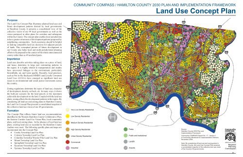
<strong>Land</strong> <strong>Use</strong> Concept Plan<br />
Purpose<br />
The <strong>Land</strong> <strong>Use</strong> Concept Plan illustrates planned land uses and<br />
future development patterns desired by local governments<br />
in <strong>Hamilton</strong> <strong>County</strong>. It presents a consolidated view of the<br />
collective vision of our 49 local governments as well as the<br />
vision portrayed in other plans for corridors and subregions<br />
within the <strong>County</strong>. The concept plan enables local jurisdictions<br />
to have greater awareness of development patterns proposed by<br />
neighboring communities. Such awareness should be helpful<br />
in making compatible land use decisions for adjacent parcels<br />
of lands. This conceptual picture of future development in<br />
our <strong>County</strong> also helps local and multi-jurisdictional planning<br />
efforts to be prepared in the context of the whole interconnected<br />
county rather than as 49 unrelated parts.<br />
Importance<br />
<strong>Land</strong> uses describe activities taking place on a piece of land,<br />
and hence determine in large part commuting patterns in<br />
the region. It is highly related to transportation and studies<br />
have uncovered linkages to the environment, particularly<br />
brownfields, air, and water quality. Recently, local practices,<br />
such as Not in My Backyard (NIMBY) and Locally Unwanted<br />
<strong>Land</strong> <strong>Use</strong>s (LULUs) have emerged as significant land use<br />
issues in environmental and social justice movements across<br />
the country.<br />
74<br />
75<br />
71<br />
275<br />
Zoning regulations determine the types of land use, character<br />
of development, density, set back, etc. In many ways, it shows<br />
the built-out scenario for the land parcels or the maximum<br />
achievable development on the land. Coupled with the land use<br />
plans, zoning affects the development patterns in the region. By<br />
considering all land use and zoning plans in <strong>Hamilton</strong> <strong>County</strong>,<br />
the <strong>Land</strong> <strong>Use</strong> Concept Plan presents a consolidated snapshot of<br />
the collective land use vision of our 49 governments.<br />
Formation<br />
The Concept Plan reflects future land use recommendations<br />
identified in the Western <strong>Hamilton</strong> <strong>County</strong> Collaborative Plan,<br />
the Eastern Corridor <strong>Land</strong> <strong>Use</strong> Vision Plan, local community<br />
plans, and local zoning plans. In the absence of local land use<br />
plans, existing land uses as recorded by the <strong>Hamilton</strong> <strong>County</strong><br />
Auditor were used. The following specific plans and maps are<br />
incorporated into the Concept Plan:<br />
• Crosby Township <strong>Land</strong> <strong>Use</strong> Plan<br />
• Colerain Township <strong>Land</strong> <strong>Use</strong> Plan<br />
• Columbia Township Wooster Pike <strong>Land</strong> <strong>Use</strong> Plan<br />
• Miami Township <strong>Land</strong> <strong>Use</strong> Plan<br />
• Springfield Township <strong>Land</strong> <strong>Use</strong> Plan<br />
• Sycamore Township <strong>Land</strong> <strong>Use</strong> Plan<br />
• Symmes Township <strong>Land</strong> <strong>Use</strong> Plan<br />
275<br />
<br />
<br />
<br />
<br />
<br />
<br />
<br />
<br />
<br />
<br />
<br />
71<br />
75<br />
471<br />
Source:<br />
<strong>Hamilton</strong> <strong>County</strong> 2030 Plan and<br />
Implementation Framework<br />
Community COMPASS Report No. 17 - Version 1<br />
A Community Workbook for Implementation Partners.<br />
November 2004.<br />
Note: By considering all land use and zoning plans in<br />
<strong>Hamilton</strong> <strong>County</strong>, the <strong>Land</strong> <strong>Use</strong> Concept Plan presents<br />
a consolidated snapshot of the collective land use vision<br />
of the <strong>County</strong>’s 49 governments.<br />
67
• Anderson Township <strong>Ohio</strong> Riverfront Comprehensive<br />
<strong>Land</strong> <strong>Use</strong> Plan<br />
• Anderson Township Draft Comprehensive Plan<br />
• Eastern Corridor <strong>Land</strong> <strong>Use</strong> Plan<br />
• Western <strong>Hamilton</strong> <strong>County</strong> Collaborative Plan<br />
Concept<br />
• <strong>Hamilton</strong> <strong>County</strong> Auditor’s <strong>Land</strong> <strong>Use</strong> Database<br />
A common set of land uses identified from these plans are<br />
represented by using a matrix of dots and colors. The system<br />
of dots presents, in abstract, the intensity and patterns of<br />
land development and types of land use. The color of the<br />
dots shows the land use, while size and spacing provide a<br />
general indication of the development patterns and community<br />
characteristics. Smaller dots with closer spacing reflect urban<br />
development patterns of higher population densities, small lots,<br />
and dense street patterns. Whereas, larger dots spaced farther<br />
apart, reflect suburban and rural character of low density and<br />
large lot residential developments. The largest non-residential<br />
dots, either stand alone or clustered in groups, show regional<br />
land uses and large employment centers.<br />
Components<br />
The main components of the concept plan are a set of standard<br />
land uses synthesized from the aforementioned plans. The<br />
residential developments in the <strong>County</strong> were inspected<br />
more closely to come up with different residential densities.<br />
Particularly, the Single Family land uses are broke up into<br />
different densities. The residential development in <strong>Hamilton</strong><br />
<strong>County</strong> varies from urban-level high densities, such as ten<br />
dwelling units or more per acre to sparse rural developments<br />
of one dwelling unit on more than one acre, permissible on<br />
agricultural lands. In addition, commercial land use shows<br />
retail and large commercial center developments; industrial<br />
land use includes light and heavy industries; and public and<br />
institutional land use includes university and public facilities.<br />
The Concept Plan also shows the major road network in the<br />
county, and local and international airports.<br />
The following land uses are included in the concept plan:<br />
• Residential Very Low Density/ Agriculture-- 1<br />
dwelling unit per 1+ acres<br />
• Residential Low Density-- 1-3 dwelling units per acre<br />
• Residential Medium Density-- 3-7 dwelling units per<br />
acre<br />
• Residential High Density-- 7-10 dwelling units per<br />
acre<br />
• Residential Urban Density-- 10 plus dwelling units<br />
per acre<br />
• Commercial (office and retail)<br />
• Industrial<br />
• Public/Semi Public<br />
• Open Space/Recreation<br />
• <strong>Land</strong>fill<br />
• Airports<br />
As the earliest developed county in the Cincinnati metropolitan<br />
area, <strong>Hamilton</strong> <strong>County</strong> hosts residential stock of every era<br />
varying from the earliest urban core developments to old<br />
streetcar suburbs to the latest single-family developments.<br />
Coupled with the topography, the varying development<br />
patterns provide uniqueness in <strong>Hamilton</strong> <strong>County</strong>’s skyline and<br />
built environment as well as its natural environment.<br />
The completed map indicates that large areas of central and<br />
eastern <strong>Hamilton</strong> <strong>County</strong> are already developed and have<br />
little remaining vacant land. Sweeping changes in land use<br />
patterns in these developed areas are unlikely, although there<br />
are opportunities for smaller-scale infill and redevelopment<br />
projects. Most large parcels of land available for development<br />
are in western <strong>Hamilton</strong> <strong>County</strong>, generally outside the I-275<br />
loop. Some smaller areas of undeveloped land also remain<br />
in Anderson Township, Symmes Township, and Sycamore<br />
Township. Existing land uses in undeveloped areas are<br />
generally low density agricultural and rural residential uses<br />
with some scattered commercial and industrial development.<br />
Also notable on the concept plan is how the interstate<br />
highways have affected development across the county.<br />
The largest regional land uses and employment centers are<br />
clustered along highway corridors and around interchanges<br />
with arterial roads.<br />
The density of dots on the map illustrates that the most compact<br />
and varied development is in the urban core of Cincinnati<br />
and its inner-ring suburbs. Progressing outward along road<br />
corridors, land uses become less intense and more suburban<br />
oriented, transitioning into very low density rural uses in<br />
western <strong>Hamilton</strong> <strong>County</strong>.<br />
Consistency With Related Plans<br />
Refinement, amendment, and implementation of the land use<br />
concept plan should be consistent with:<br />
• Community COMPASS Vision for land use and<br />
development framework<br />
• Community COMPASS core goals (with emphasis on<br />
Goal 4 – Balancing Development and the Environment)<br />
• <strong>Hamilton</strong> <strong>County</strong> Policy Plan for land use (adapted from<br />
the OKI <strong>Land</strong> <strong>Use</strong> Commission’s Strategic Regional<br />
Policy Plan)<br />
Next Steps<br />
• Convene public forums and key partner meetings<br />
to discuss the State of the <strong>County</strong> Report on land<br />
use and development framework, key indicators of<br />
progress, policy plan recommendations<br />
• Refine implementation campaign and priorities<br />
• Establish partner commitments<br />
• Identify priorities and specific action plans for<br />
Community COMPASS strategies pertaining to:<br />
• Initiative 25 (<strong>County</strong>wide Growth Plan)<br />
• Initiative 26 (Pedestrian and Bike Friendly<br />
Communities)<br />
• Initiative 27 (Revitalization Including First<br />
Suburbs)<br />
• Initiative 30 (Coordinated Planning and<br />
Infrastructure)<br />
• Update the State of the <strong>County</strong> Report on land use and<br />
development framework and related key indicators of<br />
progress every five years.<br />
Potential Key Partners<br />
Potential partners for refining and implementing the plan<br />
and initiatives include:<br />
• The AMOS Project<br />
• American Farmland Trust (Cost of Community Services<br />
study)<br />
• Citizens for Civic Renewal, Transportation Task Force<br />
• Community Revitalization Initiative (Planning<br />
Partnership)<br />
• City of Cincinnati (Strategic Program for Urban<br />
Redevelopment)<br />
• Greater <strong>Ohio</strong><br />
• <strong>Hamilton</strong> <strong>County</strong> Engineer<br />
• <strong>Hamilton</strong> <strong>County</strong> Caucus of OKI Representatives<br />
(Planning partnership)<br />
• <strong>Hamilton</strong> <strong>County</strong> Development Company (Urban <strong>Land</strong><br />
Assembly Program)<br />
• <strong>Hamilton</strong> <strong>County</strong> Commissioner’s Office (Home<br />
Improvement Program)<br />
• Housing Opportunities Made Equal<br />
• Housing and Urban Development<br />
• OKI Regional Council of Governments<br />
• <strong>Ohio</strong> Environmental Protection Agency<br />
• Port of Greater Cincinnati Development Authority<br />
(Brownfields Redevelopment Program)<br />
• Mill Creek Watershed Council<br />
Implementation Resources<br />
Potential Federal funds or grants:<br />
• Housing and Urban Development<br />
• Environmental Protection Agency<br />
• Federal Highway Administration<br />
Potential Local funds or grants:<br />
• Murray and Agnes Seasongood Foundation<br />
• Greater Cincinnati Foundation<br />
The Planning Partnership<br />
is a collaborative initiative<br />
of the <strong>Hamilton</strong> <strong>County</strong><br />
Regional Planning<br />
Commission. The<br />
Partnership – open to all<br />
political jurisdictions in<br />
the <strong>County</strong> and to affiliate<br />
members in the public,<br />
private, and civic sectors<br />
– is an advisory board<br />
that works to harness the<br />
collective energy and<br />
vision of its members to<br />
effectively plan for the<br />
future of our <strong>County</strong>.<br />
Rather than engaging in<br />
the Planning Commission’s<br />
short-range functions<br />
such as zoning reviews,<br />
the Planning Partnership<br />
takes a long-range,<br />
comprehensive approach to<br />
planning, working to build<br />
a community that works<br />
for families, for businesses<br />
and for the region. The<br />
Partnership firmly believes<br />
that collaboration is the key<br />
to a positive, competitive,<br />
and successful future for<br />
<strong>Hamilton</strong> <strong>County</strong>.<br />
Community COMPASS<br />
(<strong>Hamilton</strong> <strong>County</strong>’s<br />
Comprehensive Master<br />
Plan and Strategies) is<br />
a long-range plan that<br />
seeks to address mutual<br />
goals related to physical,<br />
economic, and social issues<br />
among the 49 communities<br />
within <strong>Hamilton</strong> <strong>County</strong>.<br />
Through a collective shared<br />
vision for the future based<br />
on the wishes and dreams<br />
of thousands of citizens,<br />
<strong>Hamilton</strong> <strong>County</strong> now has<br />
direction to chart its course<br />
into the 21 st century.<br />
In developing a broad<br />
vision with broad support,<br />
Community COMPASS<br />
will help ensure that trends<br />
are anticipated, challenges<br />
are addressed, priorities<br />
are focused, and our<br />
collective future is planned<br />
and achieved strategically<br />
over the next 20 to 30<br />
years. Through an in-depth<br />
analysis of all aspects of<br />
the <strong>County</strong>, the multi-year<br />
process will result in a<br />
comprehensive plan.<br />
Visit planningpartnership.org and<br />
communitycompass.org for more information.<br />
<strong>Hamilton</strong> <strong>County</strong> Regional Planning Commission<br />
138 East Court Street, Room 807<br />
Cincinnati, OH 45202<br />
513-946-4500 | www.hamilton-co.org/hcrpc<br />
68