- Page 1 and 2:
Camilty Wind Farm Environmental Sta
- Page 3 and 4:
Camilty Wind Farm Contents 1 Introd
- Page 6 and 7:
Camilty Wind Farm CEL:LfN CIRIA CIT
- Page 8 and 9:
Camilty Wind Farm NPF NPPG NSA NSR
- Page 10 and 11:
Camilty Wind Farm WOV WWF WWT ZTV Z
- Page 12 and 13:
Camilty Wind Farm (Scotland) Act 19
- Page 14 and 15:
Camilty Wind Farm Native A species
- Page 16 and 17:
Camilty Wind Farm 1 Introduction 1.
- Page 18 and 19:
Camilty Wind Farm site access, temp
- Page 20 and 21:
Camilty Wind Farm 1.3.8 The Scottis
- Page 22 and 23:
Camilty Wind Farm 2 The Environment
- Page 24 and 25:
Camilty Wind Farm is potential for
- Page 26 and 27:
Camilty Wind Farm Consultee Respons
- Page 28 and 29:
Camilty Wind Farm Consultee Respons
- Page 30 and 31:
Camilty Wind Farm Consultee Respons
- Page 32 and 33:
Camilty Wind Farm Consultee Respons
- Page 34 and 35:
Camilty Wind Farm Consultee Respons
- Page 36 and 37:
Camilty Wind Farm Consultee Respons
- Page 38 and 39:
Camilty Wind Farm Consultee Respons
- Page 40 and 41:
Camilty Wind Farm topic chapters. F
- Page 42 and 43:
Camilty Wind Farm 2.3.14 For some t
- Page 44 and 45:
Camilty Wind Farm Effect Secondary
- Page 46 and 47:
Camilty Wind Farm and design criter
- Page 48 and 49:
Camilty Wind Farm 3 Design Evolutio
- Page 50 and 51:
Camilty Wind Farm • Impact on avi
- Page 52 and 53:
Camilty Wind Farm Technical Criteri
- Page 54 and 55:
Camilty Wind Farm • Relationship
- Page 56 and 57:
Camilty Wind Farm process, through
- Page 58 and 59:
Camilty Wind Farm • Ornithology -
- Page 60 and 61:
Camilty Wind Farm 3.5.25 The two tu
- Page 62 and 63:
Camilty Wind Farm 4 Description of
- Page 64 and 65:
Camilty Wind Farm 4.2.5 There are s
- Page 66 and 67:
Camilty Wind Farm 4.2.18 Camilty Pl
- Page 68 and 69:
Camilty Wind Farm 4.2.33 The restoc
- Page 70 and 71:
Camilty Wind Farm Anemometry Mast 4
- Page 72 and 73:
Camilty Wind Farm 4.5.11 Access int
- Page 74 and 75:
Camilty Wind Farm a bridge structur
- Page 76 and 77:
Camilty Wind Farm Indicative Constr
- Page 78 and 79:
Camilty Wind Farm Construction Work
- Page 80 and 81:
Camilty Wind Farm there will be a t
- Page 82 and 83:
Camilty Wind Farm to the top surfac
- Page 84 and 85:
Camilty Wind Farm Waste Management
- Page 86 and 87:
Camilty Wind Farm 5 Planning Policy
- Page 88 and 89:
Camilty Wind Farm • To reduce gre
- Page 90 and 91:
Camilty Wind Farm Table 5.2 Targets
- Page 92 and 93:
Camilty Wind Farm contributes to th
- Page 94 and 95:
Camilty Wind Farm Nature Reserves (
- Page 96 and 97:
Camilty Wind Farm 5.3.57 Paragraph
- Page 98 and 99:
Camilty Wind Farm 5.4.8 The guidanc
- Page 100 and 101:
Camilty Wind Farm areas will be req
- Page 102 and 103:
Camilty Wind Farm 6 Climate Change
- Page 104 and 105:
Camilty Wind Farm 6.2.8 The report
- Page 106 and 107:
Camilty Wind Farm carbon savings fr
- Page 108 and 109:
Camilty Wind Farm Table 6.1 Propose
- Page 110 and 111:
Camilty Wind Farm 7 Traffic and Tra
- Page 112 and 113:
Camilty Wind Farm distraction of wi
- Page 114 and 115:
Camilty Wind Farm Table 7.2 Establi
- Page 116 and 117:
Camilty Wind Farm 7.3.7 The WLLP al
- Page 118 and 119:
Camilty Wind Farm TEMPRO for predic
- Page 120 and 121:
Camilty Wind Farm • A length of m
- Page 122 and 123:
Camilty Wind Farm construction brea
- Page 124 and 125:
Camilty Wind Farm Table 7.8 Constru
- Page 126 and 127:
Camilty Wind Farm vehicle speeds, i
- Page 128 and 129:
Camilty Wind Farm Table 7.9 Summary
- Page 130 and 131:
Camilty Wind Farm 8 Noise 8.1 Intro
- Page 132 and 133:
Camilty Wind Farm • The duration
- Page 134 and 135:
Camilty Wind Farm 8.3.4 The benefit
- Page 136 and 137:
Camilty Wind Farm Baseline Noise Mo
- Page 138 and 139:
Camilty Wind Farm Chart 8.1: Parkvi
- Page 140 and 141:
Camilty Wind Farm Prevailing Backgr
- Page 142 and 143:
Camilty Wind Farm Construction on S
- Page 144 and 145:
Camilty Wind Farm 8.5.23 These cons
- Page 146 and 147:
Camilty Wind Farm 8.5.28 The follow
- Page 148 and 149:
Camilty Wind Farm Chart 8.7: Halfwa
- Page 150 and 151:
Camilty Wind Farm Chart 8.11: Over
- Page 152 and 153:
Camilty Wind Farm Table 8.10 Differ
- Page 154 and 155:
Camilty Wind Farm • Deliveries sh
- Page 156 and 157:
Camilty Wind Farm 8.8 Cumulative Ef
- Page 158 and 159:
Camilty Wind Farm Chart 8.16: Colzi
- Page 160 and 161:
Camilty Wind Farm Chart 8.20: Harbu
- Page 162 and 163:
Camilty Wind Farm Chart 8.24: Whist
- Page 164 and 165:
Camilty Wind Farm 8.8.15 Chart 8.26
- Page 166 and 167:
Camilty Wind Farm 9 Landscape and V
- Page 168 and 169:
Camilty Wind Farm • The Scottish
- Page 170 and 171:
Camilty Wind Farm • Select an app
- Page 172 and 173:
Camilty Wind Farm 9.2.34 The potent
- Page 174 and 175:
Camilty Wind Farm viewpoint locatio
- Page 176 and 177:
Camilty Wind Farm landscape’ (par
- Page 178 and 179:
Camilty Wind Farm Table 9.5 Recepto
- Page 180 and 181:
Camilty Wind Farm Significance of E
- Page 182 and 183:
Camilty Wind Farm character. Where
- Page 184 and 185:
Camilty Wind Farm 9.3.10 Although t
- Page 186 and 187:
Camilty Wind Farm • Harburn House
- Page 188 and 189:
Camilty Wind Farm Local plans shoul
- Page 190 and 191:
Camilty Wind Farm • Pateshill •
- Page 192 and 193:
Camilty Wind Farm settings; however
- Page 194 and 195:
Camilty Wind Farm • Urban 9.3.54
- Page 196 and 197:
Camilty Wind Farm LCT/LCA Broughton
- Page 198 and 199:
Camilty Wind Farm LCT/LCA Landscape
- Page 200 and 201:
Camilty Wind Farm Hills lies to the
- Page 202 and 203:
Camilty Wind Farm these routes are
- Page 204 and 205:
Camilty Wind Farm centre and left h
- Page 206 and 207:
Camilty Wind Farm towards the Firth
- Page 208 and 209:
Camilty Wind Farm Viewpoint 20. For
- Page 210 and 211:
Camilty Wind Farm 9.3.118 Lights at
- Page 212 and 213:
Camilty Wind Farm The B7008 Travell
- Page 214 and 215:
Camilty Wind Farm • Harburn (nort
- Page 216 and 217:
Camilty Wind Farm are then generall
- Page 218 and 219:
Camilty Wind Farm Residential Prope
- Page 220 and 221:
Camilty Wind Farm to a small magnit
- Page 222 and 223:
Camilty Wind Farm the form of light
- Page 224 and 225:
Camilty Wind Farm Landscape Charact
- Page 226 and 227:
Camilty Wind Farm these Lowland Pla
- Page 228 and 229:
Camilty Wind Farm from negligible t
- Page 230 and 231:
Camilty Wind Farm visible above int
- Page 232 and 233:
Camilty Wind Farm slightly diminish
- Page 234 and 235:
Camilty Wind Farm forestry. The pro
- Page 236 and 237:
Camilty Wind Farm 9.5.118 At night
- Page 238 and 239:
Camilty Wind Farm hills, although t
- Page 240 and 241:
Camilty Wind Farm gained. The propo
- Page 242 and 243:
Camilty Wind Farm Receptor Effect D
- Page 244 and 245:
Camilty Wind Farm Analysis of the L
- Page 246 and 247:
Camilty Wind Farm have an effect on
- Page 248 and 249:
Camilty Wind Farm the additional cu
- Page 250 and 251:
Camilty Wind Farm associated with p
- Page 252 and 253:
Camilty Wind Farm Plantation, would
- Page 254 and 255:
Camilty Wind Farm to the south west
- Page 256 and 257:
Camilty Wind Farm Moderate addition
- Page 258 and 259:
Camilty Wind Farm Glasgow. A smalle
- Page 260 and 261:
Camilty Wind Farm • Topic Paper 9
- Page 262 and 263:
Camilty Wind Farm largely to avoid
- Page 264 and 265:
Camilty Wind Farm 10.2.14 An assess
- Page 266 and 267:
Camilty Wind Farm Table 10.2 Guide
- Page 268 and 269:
Camilty Wind Farm Asset Importance
- Page 270 and 271:
Camilty Wind Farm historic landscap
- Page 272 and 273:
Camilty Wind Farm • Stage Two: de
- Page 274 and 275:
Camilty Wind Farm Baseline Conditio
- Page 276 and 277:
Camilty Wind Farm 10.4.2 The most s
- Page 278 and 279:
Camilty Wind Farm of effect of the
- Page 280 and 281:
Camilty Wind Farm Other SMs 10.5.28
- Page 282 and 283:
Camilty Wind Farm is of high import
- Page 284 and 285:
Camilty Wind Farm 10.5.57 The liste
- Page 286 and 287:
Camilty Wind Farm 10.5.74 Some 5 km
- Page 288 and 289:
Camilty Wind Farm 10.5.90 The house
- Page 290 and 291:
Camilty Wind Farm 10.5.106 HB numbe
- Page 292 and 293:
Camilty Wind Farm Table 10.5 Summar
- Page 294 and 295:
Camilty Wind Farm included in Appen
- Page 296 and 297:
Camilty Wind Farm Table 10.6 Summar
- Page 298 and 299:
Camilty Wind Farm Receptor Effect D
- Page 300 and 301:
Camilty Wind Farm 11 Terrestrial Ec
- Page 302 and 303:
Camilty Wind Farm 11.2 Methodology
- Page 304 and 305:
Camilty Wind Farm Consultee Date of
- Page 306 and 307:
Camilty Wind Farm Bat Species 11.2.
- Page 308 and 309:
Camilty Wind Farm Index (HSI) devel
- Page 310 and 311:
Camilty Wind Farm Conservation Sens
- Page 312 and 313:
Camilty Wind Farm Table 11.6 Design
- Page 314 and 315:
Camilty Wind Farm 11.3.8 There were
- Page 316 and 317:
Camilty Wind Farm 11.3.16 Marshy gr
- Page 318 and 319:
Camilty Wind Farm NVC Code NVC Type
- Page 320 and 321:
Camilty Wind Farm was also detected
- Page 322 and 323:
Camilty Wind Farm remaining 38% wer
- Page 324 and 325:
Camilty Wind Farm Badger Legal Prot
- Page 326 and 327:
Camilty Wind Farm current landuse i
- Page 328 and 329:
Camilty Wind Farm Valued Ecological
- Page 330 and 331:
Camilty Wind Farm 11.6.8 Bat activi
- Page 332 and 333:
Camilty Wind Farm Table 11.16 Areas
- Page 334 and 335:
Camilty Wind Farm Table 11.18 Poten
- Page 336 and 337:
Camilty Wind Farm Table 11.20 Poten
- Page 338 and 339:
Camilty Wind Farm Siltbusters or eq
- Page 340 and 341:
Camilty Wind Farm 11.9 Cumulative E
- Page 342 and 343:
Camilty Wind Farm 11.9.22 It is con
- Page 344 and 345:
Camilty Wind Farm Table 11.22 Summa
- Page 346 and 347:
Camilty Wind Farm Receptor Effect D
- Page 348 and 349:
Camilty Wind Farm Receptor Effect D
- Page 350 and 351:
Camilty Wind Farm Receptor Effect D
- Page 352 and 353:
Camilty Wind Farm • NBN Gateway W
- Page 354 and 355:
Camilty Wind Farm 12.2 Methodology
- Page 356 and 357:
Camilty Wind Farm activity, particu
- Page 358 and 359:
Camilty Wind Farm 12.2.10 In additi
- Page 360 and 361:
Camilty Wind Farm Flight Activity S
- Page 362 and 363:
Camilty Wind Farm (ii) For a sample
- Page 364 and 365:
Camilty Wind Farm 12.2.40 The Town
- Page 366 and 367:
Camilty Wind Farm Level of Effect S
- Page 368 and 369:
Camilty Wind Farm Table 12.8 Desk-b
- Page 370 and 371:
Camilty Wind Farm Table 12.10 Fligh
- Page 372 and 373:
Camilty Wind Farm 12.3.19 All speci
- Page 374 and 375:
Camilty Wind Farm Table 12.13 Speci
- Page 376 and 377:
Camilty Wind Farm Collision Risk Mo
- Page 378 and 379:
Camilty Wind Farm • Goshawk; •
- Page 380 and 381:
Camilty Wind Farm Species Recorded
- Page 382 and 383:
Camilty Wind Farm Species Recorded
- Page 384 and 385:
Camilty Wind Farm Species Recorded
- Page 386 and 387:
Camilty Wind Farm Species Recorded
- Page 388 and 389:
Camilty Wind Farm sites for the sam
- Page 390 and 391:
Camilty Wind Farm 12.3.52 In summar
- Page 392 and 393:
Camilty Wind Farm Given that the Ph
- Page 394 and 395: Camilty Wind Farm three VORs (i.e.
- Page 396 and 397: Camilty Wind Farm there is an abund
- Page 398 and 399: Camilty Wind Farm 12.5.40 It is exp
- Page 400 and 401: Camilty Wind Farm 12.5.49 Based on
- Page 402 and 403: Camilty Wind Farm above), then conn
- Page 404 and 405: Camilty Wind Farm 12.5.67 The most
- Page 406 and 407: Camilty Wind Farm (or during any ma
- Page 408 and 409: Camilty Wind Farm while all other s
- Page 410 and 411: Camilty Wind Farm 12.8 Cumulative E
- Page 412 and 413: Camilty Wind Farm stages of develop
- Page 414 and 415: Camilty Wind Farm wind farms are al
- Page 416 and 417: Camilty Wind Farm 12.8.36 Surveys a
- Page 418 and 419: Camilty Wind Farm considered to mat
- Page 420 and 421: Camilty Wind Farm Receptor Sensitiv
- Page 422 and 423: Camilty Wind Farm Receptor Sensitiv
- Page 424 and 425: Camilty Wind Farm • IPCC (2005).
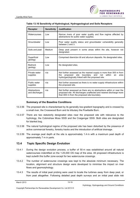
- Page 426 and 427: Camilty Wind Farm 13 Hydrology, Hyd
- Page 428 and 429: Camilty Wind Farm Table 13.1 Criter
- Page 430 and 431: Camilty Wind Farm 13.2.6 Effects ar
- Page 432 and 433: Camilty Wind Farm Baseline Survey G
- Page 434 and 435: Camilty Wind Farm Source Other guid
- Page 436 and 437: Camilty Wind Farm Land-use and Topo
- Page 438 and 439: Camilty Wind Farm Groundwater Flood
- Page 440 and 441: Camilty Wind Farm Table 13.13 Distr
- Page 442 and 443: Camilty Wind Farm Public Water Supp
- Page 446 and 447: Camilty Wind Farm Table 13.17 Compa
- Page 448 and 449: Camilty Wind Farm 13.5.32 The site
- Page 450 and 451: Camilty Wind Farm Superficial Depos
- Page 452 and 453: Camilty Wind Farm 110% of the fuel
- Page 454 and 455: Camilty Wind Farm • Improving wat
- Page 456 and 457: Camilty Wind Farm March 2013 be nea
- Page 458 and 459: Camilty Wind Farm Table 13.18 Summa
- Page 460 and 461: Camilty Wind Farm Receptor Effect D
- Page 462 and 463: Camilty Wind Farm • Scottish Gove
- Page 464 and 465: Camilty Wind Farm (as shown on Figu
- Page 466 and 467: Camilty Wind Farm at the time of oc
- Page 468 and 469: Camilty Wind Farm Criteria for Magn
- Page 470 and 471: Camilty Wind Farm • “The locati
- Page 472 and 473: Camilty Wind Farm 15.3.11 The econo
- Page 474 and 475: Camilty Wind Farm Land Use 15.3.19
- Page 476 and 477: Camilty Wind Farm 15.3.30 Tourism f
- Page 478 and 479: Camilty Wind Farm • Linlithgow Ca
- Page 480 and 481: Camilty Wind Farm were not availabl
- Page 482 and 483: Camilty Wind Farm • A 5.5 km trai
- Page 484 and 485: Camilty Wind Farm 15.4.6 In additio
- Page 486 and 487: Camilty Wind Farm 15.4.19 Given the
- Page 488 and 489: Camilty Wind Farm exploration of hi
- Page 490 and 491: Camilty Wind Farm • A705 between
- Page 492 and 493: Camilty Wind Farm of the views that
- Page 494 and 495:
Camilty Wind Farm Table 15.9 Summar
- Page 496 and 497:
Camilty Wind Farm Receptor Effect D
- Page 498 and 499:
Camilty Wind Farm Receptor Effect D
- Page 500 and 501:
Camilty Wind Farm the justification
- Page 502 and 503:
Camilty Wind Farm 16 Summary of Eff
- Page 504 and 505:
Camilty Wind Farm Table 16.2 Summar
- Page 506 and 507:
Camilty Wind Farm Receptor Effect D
- Page 508 and 509:
Camilty Wind Farm Receptor Effect D
- Page 510 and 511:
Camilty Wind Farm Receptor Effect D
- Page 512 and 513:
Camilty Wind Farm Table 16.5 Summar
- Page 514 and 515:
Camilty Wind Farm Receptor Effect D
- Page 516 and 517:
Camilty Wind Farm Receptor Effect D
- Page 518 and 519:
Camilty Wind Farm Receptor Effect D
- Page 520 and 521:
Camilty Wind Farm Receptor Effect D
- Page 522 and 523:
Camilty Wind Farm Level of Level of
- Page 524 and 525:
Camilty Wind Farm Level of Level of
- Page 526 and 527:
Camilty Wind Farm Receptor Effect D
- Page 528 and 529:
Camilty Wind Farm Receptor Effect D
- Page 530 and 531:
Camilty Wind Farm Receptor Effect D
- Page 532 and 533:
Camilty Wind Farm Receptor Effect D
- Page 534 and 535:
Camilty Wind Farm site management.
- Page 536 and 537:
Camilty Wind Farm Topic Landscape a
- Page 538 and 539:
Camilty Wind Farm Topic Key Mitigat
- Page 540 and 541:
Camilty Wind Farm Topic Hydrology,
- Page 542 and 543:
Camilty Wind Farm Topic Key Mitigat
- Page 544 and 545:
Camilty Wind Farm Topic Key Mitigat
- Page 546 and 547:
Camilty Wind Farm Topic Key Mitigat