Camilty Wind Farm - Partnerships for Renewables
Camilty Wind Farm - Partnerships for Renewables Camilty Wind Farm - Partnerships for Renewables
Camilty Wind Farm 13.2.6 Effects are identified by comparing the baseline hydrological, hydrogeological and ground conditions and how these would change over time without the project occurring (the “donothing”) scenario and how the baseline would likely change as a result of the development. Effects can be either positive (improving the baseline scenario) or adverse (detrimental to the baseline scenario). 13.2.7 Having identified and characterised the potential effects that may arise during the construction, operation and decommissioning of the wind farm, the significance of effect can be assessed by taking into consideration the magnitude of effect predicted in relation to the sensitivity of the baseline. 13.2.8 To determine the likely magnitude of effects, it is necessary to consider the timing, scale, size and duration of the potential activities. For the purposes of this assessment the magnitude criteria are defined as follows in Table 13.2. Table 13.2 Criteria for Defining Magnitude of Effect Magnitude Criteria Description and Example Large Medium Small Negligible Results in loss of attribute Affects integrity of attribute or partial loss of attribute Results in minor effect on attribute Results in an effect on attribute but of insufficient magnitude to affect the use/integrity • Fundamental (long term or permanent) changes to geology, hydrology, water quality and hydrogeology; • Loss of designated Salmonid Fishery; • Loss of national level designated species/habitats; • Changes in WFD water quality status of river reach; • Loss of flood storage/increased flood risk; and • Pollution of potable source of abstraction compared to predevelopment conditions • Material but non-fundamental and short to medium term changes to the geology, hydrology, water quality and hydrogeology; • Loss in productivity of a fishery; • Contribution of a significant proportion of the discharges in the receiving water, but insignificant enough to change its water quality status; and • No increase in flood risk. • Detectable but non-material and transitory changes to the geology, hydrology, water quality and hydrogeology; and • No increase in flood risk. • No perceptible changes to the geology, hydrology, water quality and hydrogeology; • Discharges to watercourse but no reduction in quality, fishery productivity or biodiversity; and • No increase in flood risk. 13.2.9 Once the magnitude of any potential effects are assessed, the results can be compared with the sensitivity of the baseline environment and used to define the Level of the effect as outlined in Table 13.3. March 2013 13-5 Copyright Partnerships for Renewables Development Co. Ltd 2013 © Hydrology, Hydrogeology and Ground Conditions
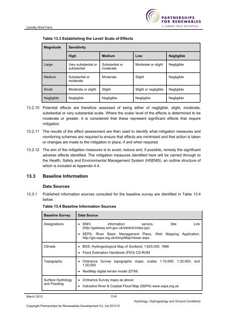
Camilty Wind Farm Table 13.3 Establishing the Level/ Scale of Effects Magnitude Sensitivity High Medium Low Negligible Large Very substantial or substantial Substantial or moderate Moderate or slight Negligible Medium Substantial or moderate Moderate Slight Negligible Small Moderate or slight Slight Slight or negligible Negligible Negligible Negligible Negligible Negligible Negligible 13.2.10 Potential effects are therefore assessed of being either of negligible, slight, moderate, substantial or very substantial scale. Where the scale/ level of the effects is determined to be moderate or greater, it is considered that these represent significant effects that require mitigation. 13.2.11 The results of the effect assessment are then used to identify what mitigation measures and monitoring schemes are required to ensure that effects are minimised and that action is taken or changes are made to the mitigation in place, if and when required. 13.2.12 The aim of the mitigation measures is to avoid, reduce and, if possible, remedy the significant adverse effects identified. The mitigation measures identified here will be carried through to the Health, Safety and Environmental Management System (HSEMS), an outline structure of which is included at Appendix 4.4. 13.3 Baseline Information Data Sources 13.3.1 Published information sources consulted for the baseline survey are identified in Table 13.4 below. Table 13.4 Baseline Information Sources Baseline Survey Data Source Designations • SNHi information service, Site Link (http://gateway.snh.gov.uk/sitelink/index.jsp) • SEPA, River Basin Management Plans, Web Mapping Application, http://gis.sepa.org.uk/rbmp/MapViewer.aspx Climate • BGS, Hydrogeological Map of Scotland, 1:625,000, 1988 • Flood Estimation Handbook (FEH) CD-ROM Topography Surface Hydrology and Flooding • Ordnance Survey topographic maps, scales 1:10,000; 1:25,000; and 1:50,000 • NextMap digital terrain model (DTM) • Ordnance Survey maps as above • Indicative River & Coastal Flood Map (SEPA) www.sepa.org.uk March 2013 13-6 Copyright Partnerships for Renewables Development Co. Ltd 2013 © Hydrology, Hydrogeology and Ground Conditions
- Page 380 and 381: Camilty Wind Farm Species Recorded
- Page 382 and 383: Camilty Wind Farm Species Recorded
- Page 384 and 385: Camilty Wind Farm Species Recorded
- Page 386 and 387: Camilty Wind Farm Species Recorded
- Page 388 and 389: Camilty Wind Farm sites for the sam
- Page 390 and 391: Camilty Wind Farm 12.3.52 In summar
- Page 392 and 393: Camilty Wind Farm Given that the Ph
- Page 394 and 395: Camilty Wind Farm three VORs (i.e.
- Page 396 and 397: Camilty Wind Farm there is an abund
- Page 398 and 399: Camilty Wind Farm 12.5.40 It is exp
- Page 400 and 401: Camilty Wind Farm 12.5.49 Based on
- Page 402 and 403: Camilty Wind Farm above), then conn
- Page 404 and 405: Camilty Wind Farm 12.5.67 The most
- Page 406 and 407: Camilty Wind Farm (or during any ma
- Page 408 and 409: Camilty Wind Farm while all other s
- Page 410 and 411: Camilty Wind Farm 12.8 Cumulative E
- Page 412 and 413: Camilty Wind Farm stages of develop
- Page 414 and 415: Camilty Wind Farm wind farms are al
- Page 416 and 417: Camilty Wind Farm 12.8.36 Surveys a
- Page 418 and 419: Camilty Wind Farm considered to mat
- Page 420 and 421: Camilty Wind Farm Receptor Sensitiv
- Page 422 and 423: Camilty Wind Farm Receptor Sensitiv
- Page 424 and 425: Camilty Wind Farm • IPCC (2005).
- Page 426 and 427: Camilty Wind Farm 13 Hydrology, Hyd
- Page 428 and 429: Camilty Wind Farm Table 13.1 Criter
- Page 432 and 433: Camilty Wind Farm Baseline Survey G
- Page 434 and 435: Camilty Wind Farm Source Other guid
- Page 436 and 437: Camilty Wind Farm Land-use and Topo
- Page 438 and 439: Camilty Wind Farm Groundwater Flood
- Page 440 and 441: Camilty Wind Farm Table 13.13 Distr
- Page 442 and 443: Camilty Wind Farm Public Water Supp
- Page 444 and 445: Camilty Wind Farm Table 13.16 Sensi
- Page 446 and 447: Camilty Wind Farm Table 13.17 Compa
- Page 448 and 449: Camilty Wind Farm 13.5.32 The site
- Page 450 and 451: Camilty Wind Farm Superficial Depos
- Page 452 and 453: Camilty Wind Farm 110% of the fuel
- Page 454 and 455: Camilty Wind Farm • Improving wat
- Page 456 and 457: Camilty Wind Farm March 2013 be nea
- Page 458 and 459: Camilty Wind Farm Table 13.18 Summa
- Page 460 and 461: Camilty Wind Farm Receptor Effect D
- Page 462 and 463: Camilty Wind Farm • Scottish Gove
- Page 464 and 465: Camilty Wind Farm (as shown on Figu
- Page 466 and 467: Camilty Wind Farm at the time of oc
- Page 468 and 469: Camilty Wind Farm Criteria for Magn
- Page 470 and 471: Camilty Wind Farm • “The locati
- Page 472 and 473: Camilty Wind Farm 15.3.11 The econo
- Page 474 and 475: Camilty Wind Farm Land Use 15.3.19
- Page 476 and 477: Camilty Wind Farm 15.3.30 Tourism f
- Page 478 and 479: Camilty Wind Farm • Linlithgow Ca
<strong>Camilty</strong> <strong>Wind</strong> <strong>Farm</strong><br />
Table 13.3 Establishing the Level/ Scale of Effects<br />
Magnitude<br />
Sensitivity<br />
High Medium Low Negligible<br />
Large<br />
Very substantial or<br />
substantial<br />
Substantial or<br />
moderate<br />
Moderate or slight<br />
Negligible<br />
Medium<br />
Substantial or<br />
moderate<br />
Moderate Slight Negligible<br />
Small Moderate or slight Slight Slight or negligible Negligible<br />
Negligible Negligible Negligible Negligible Negligible<br />
13.2.10 Potential effects are there<strong>for</strong>e assessed of being either of negligible, slight, moderate,<br />
substantial or very substantial scale. Where the scale/ level of the effects is determined to be<br />
moderate or greater, it is considered that these represent significant effects that require<br />
mitigation.<br />
13.2.11 The results of the effect assessment are then used to identify what mitigation measures and<br />
monitoring schemes are required to ensure that effects are minimised and that action is taken<br />
or changes are made to the mitigation in place, if and when required.<br />
13.2.12 The aim of the mitigation measures is to avoid, reduce and, if possible, remedy the significant<br />
adverse effects identified. The mitigation measures identified here will be carried through to<br />
the Health, Safety and Environmental Management System (HSEMS), an outline structure of<br />
which is included at Appendix 4.4.<br />
13.3 Baseline In<strong>for</strong>mation<br />
Data Sources<br />
13.3.1 Published in<strong>for</strong>mation sources consulted <strong>for</strong> the baseline survey are identified in Table 13.4<br />
below.<br />
Table 13.4 Baseline In<strong>for</strong>mation Sources<br />
Baseline Survey<br />
Data Source<br />
Designations • SNHi in<strong>for</strong>mation service, Site Link<br />
(http://gateway.snh.gov.uk/sitelink/index.jsp)<br />
• SEPA, River Basin Management Plans, Web Mapping Application,<br />
http://gis.sepa.org.uk/rbmp/MapViewer.aspx<br />
Climate • BGS, Hydrogeological Map of Scotland, 1:625,000, 1988<br />
• Flood Estimation Handbook (FEH) CD-ROM<br />
Topography<br />
Surface Hydrology<br />
and Flooding<br />
• Ordnance Survey topographic maps, scales 1:10,000; 1:25,000; and<br />
1:50,000<br />
• NextMap digital terrain model (DTM)<br />
• Ordnance Survey maps as above<br />
• Indicative River & Coastal Flood Map (SEPA) www.sepa.org.uk<br />
March 2013<br />
13-6<br />
Copyright <strong>Partnerships</strong> <strong>for</strong> <strong>Renewables</strong> Development Co. Ltd 2013 ©<br />
Hydrology, Hydrogeology and Ground Conditions


