GPS Receiver GP-E2 Specification Sheet - Canon Europe
GPS Receiver GP-E2 Specification Sheet - Canon Europe
GPS Receiver GP-E2 Specification Sheet - Canon Europe

Create successful ePaper yourself
Turn your PDF publications into a flip-book with our unique Google optimized e-Paper software.
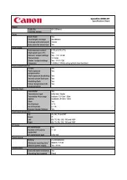
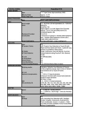
TYPE<br />
<strong><strong>GP</strong>S</strong><br />
Digital Compass<br />
Logging<br />
<strong><strong>GP</strong>S</strong> Modes<br />
Type <strong><strong>GP</strong>S</strong> receiver<br />
Compatible cameras Automatic geotagging when shooting supported by <strong>Canon</strong> EOS 5D Mark III<br />
and EOS-1D X and later cameras (7D: supported with a firmware update)<br />
Manual geotagging after shooting (from logging information)<br />
supported by all EOS digital cameras<br />
Location information Latitude, longitude, altitude, and time (UTC)<br />
Reception frequency 1575.42 MHz (L1 band) 1<br />
Positioning interval Every 1, 5, 10, 15, or 30 seconds, or every 1, 2, or 5 minutes<br />
Satellite reception Shown on the <strong><strong>GP</strong>S</strong> indicator (red)<br />
Before signal acquisition: Fast blinking<br />
Signal acquired: Slow blinking<br />
Self contained navigation Not supported<br />
Type Direction calculated using a triaxial geomagnetic sensor and triaxial<br />
acceleration sensor 2<br />
Direction positioning Constant positioning<br />
interval<br />
Calibration Supported<br />
Logging interval Every 1, 5, 10, 15, or 30 seconds, or every 1, 2, or 5 minutes<br />
Log file format NMEA-0813<br />
File creation interval One file per day<br />
Memory level display None 3<br />
File usage Images can be geotagged using Map Utility with log files.<br />
Log files can be converted to KMZ files using Map Utility.<br />
Routes the camera has travelled can be viewed in Google Earth or other<br />
map software by loading the KMZ files.<br />
Power switch set to Location information (latitude, longitude, altitude, direction, and<br />
UTC time) is automatically added to images Exif information when<br />
taking pictures.<br />
Power switch set to <br />
(logging mode)<br />
<strong><strong>GP</strong>S</strong> <strong>Receiver</strong> <strong>GP</strong>-<strong>E2</strong><br />
<strong>Specification</strong> <strong>Sheet</strong><br />
Location information (latitude, longitude, altitude, and UTC time) is recorded<br />
on <strong><strong>GP</strong>S</strong> <strong>Receiver</strong> <strong>GP</strong>-<strong>E2</strong> at the specified interval.<br />
Location information (latitude, longitude, altitude, direction, and UTC time)<br />
is automatically added to images Exif information when taking pictures.<br />
Connected to a computer Supports the following operations when <strong><strong>GP</strong>S</strong> <strong>Receiver</strong> <strong>GP</strong>-<strong>E2</strong> is connected to<br />
a computer and Map Utility is used to access <strong><strong>GP</strong>S</strong> <strong>Receiver</strong> <strong>GP</strong>-<strong>E2</strong> log files.<br />
Import logs to the computer<br />
Delete logs<br />
Manually geotag shots without <strong><strong>GP</strong>S</strong> information by adding location<br />
information (latitude, longitude, altitude, and UTC time) to image Exif<br />
information<br />
View a route of where the camera has travelled on a map<br />
Produce KMZ files from log files<br />
Update <strong><strong>GP</strong>S</strong> <strong>Receiver</strong> <strong>GP</strong>-<strong>E2</strong> firmware
Time adjustment<br />
Type Set <strong><strong>GP</strong>S</strong> time data on the camera 4,2<br />
Clock precision High-precision time adjustment: ±0.2 sec. 5<br />
Normal time adjustment: ±1 sec.<br />
Updating Interval Auto update: After satellite reception when <strong><strong>GP</strong>S</strong> <strong>Receiver</strong> <strong>GP</strong>-<strong>E2</strong> is turned on<br />
Immediate updating<br />
Hotshoe For direct camera connection<br />
Digital Port For connection via dedicated interface cable to USB port 6<br />
Interface<br />
POWER SUPPLY<br />
Power supply Off/On/Logging<br />
Power switch One AA/LR6 alkaline battery<br />
Battery life<br />
Approx. 92 hours with postioning interval set to 5minutes<br />
(continuous positioning)<br />
Battery check Indicated by the battery check lamp (red)<br />
Level OK: Slow blinking<br />
Low battery: Fast blinking<br />
Replace battery: Off<br />
PHYSICAL SPECIFICATIONS<br />
Colour Black<br />
Dimensions 54 x 73 x 44mm<br />
Weight Approx. 81g<br />
Operating Environment 0 – 45 °C, 85% or less humidity<br />
RELATED PRODUCTS<br />
Accessories Storage case, Interface cables, Soft case, Map Utility<br />
All data is based on <strong>Canon</strong> standard testing methods except where indicated<br />
Subject to change without notice<br />
[1] L1 band: Frequency allocated for civilian use. Other frequencies include the L2 band (military use) and L5 band (highprecision<br />
civilian use)<br />
[2] Not compatible with EOS 7D even with firmware update<br />
[3] When memory is full, older data is overwritten with new data.<br />
[4] Requires signal acquisition from four or more satellites<br />
[5] Margin of error relative to UTC time.<br />
High-precision time adjustment is only available for EOS-1D X<br />
[6] Transmission via cable is used if <strong><strong>GP</strong>S</strong> <strong>Receiver</strong> <strong>GP</strong>-<strong>E2</strong> is attached to the hot shoe and connected by cable.


![XEED SX800 [PDF, 137 KB] - Canon Europe](https://img.yumpu.com/2680046/1/184x260/xeed-sx800-pdf-137-kb-canon-europe.jpg?quality=85)