France - IHO
France - IHO
France - IHO

Create successful ePaper yourself
Turn your PDF publications into a flip-book with our unique Google optimized e-Paper software.
7. Capacity Building Offer of and/or demand for Capacity Building<br />
7.1. Training received, needed, offered<br />
Morocco: <strong>France</strong> has implemented with Morocco a transfer of hydrographic and cartographic<br />
responsibilities mechanism, based on training programmes, consulting and including practical<br />
experience at sea. An agreement has been signed in January 2008 for the period 2008-2013. Since<br />
the last conference, the following trainings have been completed:<br />
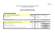
Course Year Student<br />
Cat.B Hydrographic course (18 months) 2011 - 2012<br />
2012 - 2013<br />
1<br />
1<br />
Cartographic training course (9 months)<br />
(officer and petty-officer)<br />
2010 - 2011 2<br />
Algeria: An Algerian naval forces petty-officer has completed SHOM’s category B hydrographic<br />
training course at the end of July 2011.<br />
Initial training capabilities provided by SHOM are described in its yearly report available on<br />
www.shom.fr.<br />
7.2. Status of national, bilateral, multilateral or regional development projects with<br />
hydrographic component<br />
Morocco: In the frame of the bilateral agreement signed in 2008 between <strong>France</strong> and Morocco,<br />
SHOM, a limited survey of the harbours of Ksar Sghir and Tanger Ville has been performed in 2011.<br />
Tunisia: A draft agreement for chart coproduction and distribution is under consideration by<br />
Tunisia.<br />
For the countries benefiting from SHOM support to meet the hydrographic services requirements<br />
spelled out by the SOLAS convention, <strong>France</strong> fosters a mechanism of gradual transfer of<br />
responsibilities through State-to-State administrative arrangements. This mechanism relies on<br />
training at SHOM facilities and the formalisation of the respective responsibilities for maritime<br />
safety information, hydrographic and charting activities.<br />
NTR.<br />
7.3. Definition of bids to <strong>IHO</strong>CBC<br />
8. Oceanographic activities<br />
NTR.<br />
8.1. GEBCO/IBC’s activities<br />
8.2. Tide gauge network<br />
Main tide gauge networks in the Mediterranean Sea (RONIM from SHOM, and other partners) are<br />
available on the REFMAR tide gauge webportal, operated by SHOM (http://refmar.shom.fr),<br />
together with the necessary metadata. When possible, raw data are available in near real time.<br />
RONIM tide gauges data are also available on the IOC sea level facility website.<br />
Since the last MBSHC conference, SHOM has installed two new radar tide gauges with real time<br />
transmission in Port Ferréol and Port-La-Nouvelle that contribute to tsunami and storm surge<br />
warning systems.<br />
IGN, University of La Rochelle and SHOM are working together to recover, digitize and analyse sea<br />
level paper records from GLOSS Marseille observatory dating back from 1885. This work is<br />
expected to deliver information on last century sea level rise along the French Mediterranean coast.<br />
10/14