France - IHO
France - IHO
France - IHO

Create successful ePaper yourself
Turn your PDF publications into a flip-book with our unique Google optimized e-Paper software.
SERVICE HYDROGRAPHIQUE<br />
ET OCEANOGRAPHIQUE<br />
DE LA MARINE<br />
DIRECTION DES MISSIONS<br />
INSTITUTIONNELLES ET DES<br />
RELATIONS INTERNATIONALES<br />
Dossier suivi par<br />
IETA Eric Langlois<br />
Head of the external relations division<br />
Tel : +33 1 53 66 97 81<br />
Fax : +33 1 41 74 94 23<br />
Mél : eric.langlois@shom.fr<br />
Paris, the 10 th of September 2013<br />
N° 013 SHOM/DMI/REX/NP<br />
FRENCH NATIONAL REPORT<br />
TO THE 18 TH MEETING OF THE MEDITERRANEAN AND BLACK SEA<br />
HYDROGRAPHIC COMMISSION<br />
-------<br />
-<br />
1. Hydrographic Service: General<br />
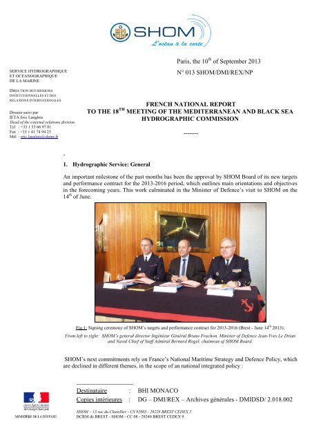
An important milestone of the past months has been the approval by SHOM Board of its new targets<br />
and performance contract for the 2013-2016 period, which outlines main orientations and objectives<br />
in the forecoming years. This work culminated in the Minister of Defence’s visit to SHOM on the<br />
14 th of June.<br />
Fig.1: Signing ceremony of SHOM’s targets and performance contract for 2013-2016 (Brest - June 14 th 2013).<br />
From left to right: SHOM’s general director Ingénieur Général Bruno Frachon, Minister of Defence Jean-Yves Le Drian<br />
and Naval Chief of Staff Admiral Bernard Rogel, chaimran of SHOM Board.<br />
SHOM’s next commitments rely on <strong>France</strong>’s National Maritime Strategy and Defence Policy, which<br />
are declined in different themes, in the scope of an national integrated policy :<br />
__________________<br />
Destinataire : BHI MONACO<br />
Copies intérieures : DG – DMI/REX – Archives générales - DMIDSD/ 2.018.002<br />
SHOM – 13 rue du Chatellier - CS 92803 - 29228 BREST CEDEX 2<br />
BCRM de BREST - SHOM - CC 08 - 29240 BREST CEDEX 9
• Environment protection<br />
• Risk assessment and coastline management<br />
• Knowledge, research and innovation<br />
• Sustainable development of maritime and littoral economy<br />
• Involvement in International and European policies<br />
• Defence support<br />
It is worth noting that in the meantime, a new prioritized 4-years survey plan for all the waters under<br />
French jurisdiction has been approved.<br />
Fig.2a (left)/b (right): National Hydrographic Plan (NHP) for the 2013-2016<br />
2. Surveys<br />
2.1. Coverage of new surveys<br />
Since the last meeting (June 2011), no extensive survey has been conducted in SHOM’s<br />
MBSHC area of responsibility. However, several limited surveys have been achieved since 2011<br />
such as:<br />
- some routine checks performed by ships and launches in several ports along the French<br />
Mediterranean coasts,<br />
- Two short surveys on port approaches in Lebanon (Zahrani and Tripoli) conducted in 2011,<br />
- A limited survey performed in 2011 within the framework of a bilateral agreement between<br />
<strong>France</strong> and Morocco: harbours of Ksar Sghir and Tanger Ville.<br />
2/14
Besides, further calibrations surveys by launches have been conducted in connection with Lidar<br />
surveys in the frame of Litto3D project (see next section for details).<br />
2.2. LIDAR surveys<br />
Since the last conference, the French Mediterranean coasts (except Corsica) were surveyed by Lidar<br />
technology, under Litto3D® project coordinated by the French National Geographic Institute (IGN)<br />
and SHOM. The Litto 3 D® project was then created to meet more than hundred requirements<br />
expressed by coastal managers concerned with the protection and exploitation of the littoral, and by<br />
users of geo-referenced data. It aims to provide a very high resolution Sea-Land digital terrain model<br />
(DTM) of metropolitan and overseas French coasts.<br />
For more information please contact litto3d@shom.fr<br />
Fig.3: LIDAR surveys achieved in the region since 17 th MBSHC.<br />
(2011: Languedoc-Roussillon region; 2012: Provence-Alpes-Côte d’Azur region)<br />
2.3. French Survey programme for the region<br />
SHOM’s survey planning for the area is detailed in the two figures hereafter, presenting the longterm<br />
objectives regarding the compliance with S-44 (fig. 3) and the 2013-2016 survey plan combined<br />
with existing surveys (fig.4): the survey programme for the Mediterranean area is composed of:<br />
- coastal surveys in Corsica (main harbours approaches, anchor areas),<br />
- survey work near Toulon (Southern part of île du Levant).<br />
3/14
Fig.4: Long term objectives for the region (source: 2013-2016 NHP)<br />
Fig.5: Existing surveys and survey planning for the 2013-2016 period (source: 2013-2016 NHP)<br />
As requested by MBSHC during its 17th Conference (decision 20), information regarding the status<br />
of French hydrographic surveys has been transmitted to Spain.<br />
2.4. New technologies and /or equipment<br />
NTR.<br />
2.5. New ships<br />
NTR.<br />
2.6. Problems encountered<br />
4/14
As many other <strong>IHO</strong> member states, <strong>France</strong> is tasked with collecting nautical information and<br />
surveying areas that would otherwise remain uncharted. It happens from time to time that SHOM<br />
only learns by accident of surveys performed by private companies, or even other HOs, in its areas of<br />
charting responsibility, and has to insist to obtain communication of <strong>IHO</strong>-compliant data relevant to<br />
INT charts and nautical information.<br />
In the interest of the maritime community, it is reminded that survey results should be<br />
communicated to the <strong>IHO</strong> recognised charting authority (in accordance with M-3 resolution<br />
1/2006 and S-4 resolution A-402.1 and B-635.4).<br />
3. New charts & updates<br />
3.1. ENCs<br />
On the 1 st of June 2013, SHOM had produced some 381 ENCs at an approximate rate of 40 per year.<br />
The full collection over French Metropolitan coasts should eventually reach a figure around 677<br />
ENCs. In line with the WEND principles, <strong>France</strong> produces its small scale ENC cells as closely as<br />
possible to INT chart schemes. The French production plan is also compliant with IMO regulations<br />
on ECDIS mandatory carriage requirements.<br />
The SHOM ENC coverage of the MBSHC area is depicted in the chartlets hereafter.<br />
Fig.6: SHOM’s actual ENC Coverage over Western Mediterranean coasts.<br />
5/14
Fig.7: SHOM’s actual ENC Coverage over Eastern Mediterranean coasts.<br />
The cells produced since the last conference (June 2011) are as follows:<br />
Number<br />
New chart<br />
(NC) or<br />
new<br />
edition<br />
(NE)<br />
Scale 1:<br />
Title<br />
FR474090 NE 50 000 Rade d'Agay à la baie de Beaulieu<br />
FR670930 NE 10 000 Rade de Toulon<br />
FR369510 NE 250 000 De Fos-sur-Mer à Menton<br />
FR370080 NE 250 000 Du Cap Cerbère à la Pointe de Beauduc<br />
FR370250 NE 250 000 Ile de Corse<br />
FR57514C NC 25 000 Liban - Abords de Saida<br />
FR566840 NE 25 000 Golfe et port de Fos-sur-Mer<br />
FR403360 NE 50 000 Approches de Fos-sur Mer<br />
FR403330 NE 50 000 Approches de Marseille<br />
FR369510 NE 250 000 De Fos-sur-Mer à Menton<br />
FR270140 NE 1 000 000 Des Iles Baléares à la Corse et à la Sardaigne<br />
FR566840 NE 25 000 Port de Fos-sur-Mer<br />
It is worth mentioning that a new scheme of the usage band 3 ENCs has been established based on<br />
the paper chart limits (reducing 17 cells into 3 cells).<br />
An overlap between a French ENC and an Italian ENC has been solved by the issue of new editions<br />
of the two ENCs.<br />
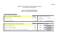
The following cells are planned in 2013-2014 :<br />
6/14
Number Scale 1: Title<br />
FR468230 50 000 Abords Sud de Bastia<br />
FR468550 50 000 Du Phare d'Alistro à Solenzara<br />
FR67392A 5 000 A - Port de Carry-le-Rouet<br />
FR67392B 5 000 B - Port de Sausset-les-Pins<br />
FR67393A 5 000 A - Port de Cassis<br />
FR66612A 7 500 A - Port de La Ciotat<br />
FR66616A 7 500 A - Bormes-les-Mimosas<br />
FR66616B 7 500 B - Cavalaire-sur-Mer<br />
FR67282A 7 500<br />
A - Port d'Hyères (Port Saint-<br />
Pierre)<br />
FR67282B 7 500 B - Port de Miramar<br />
FR67267B 10 000 B - Sainte-Maxime<br />
FR66838A 7 500 A - Port-Fréjus<br />
FR66838B 7 500 B - Vieux Port - Saint-Raphaël<br />
FR66838C 7 500<br />
C - Port Santa-Lucia - Saint-<br />
Raphaël<br />
FR67200B 7 500 B - Marina Baie des Anges<br />
FR67200C 7 500 C - Port de Saint-Laurent-du-Var<br />
FR67205B 7 500 B - Port de Cannes-Marina<br />
FR67205C 7 500 C - Port de Cannes<br />
FR67205D 7 500 D - Port Pierre Canto<br />
FR67205E 7 500 E - Ports de Golfe Juan<br />
FR67205F 7 500 F - Ports de Juan les Pins<br />
The status of ENC production in the area is:<br />
Usage Band Produced Cells Planned Cells %<br />
1 0 0 /<br />
2 1 1 100,0<br />
3 4 4 100,0<br />
4 20 22 91,0<br />
5 31<br />
82 56,6<br />
6 12<br />
Total 68 109 62,4<br />
3.2. ENC Distribution method<br />
All French ENCs are distributed to End User Service Providers by PRIMAR RENC. FR is<br />
providing its support to the IC-ENC-PRIMAR Cooperation Committee working groups to develop a<br />
RENC-to-RENC cooperation concept.<br />
NTR.<br />
3.3. RNCs<br />
3.4. INT charts<br />
See next section for details.<br />
7/14
The overall planning of SHOM for INT charts production in the region is as follows:<br />
Scale Produced INT charts Planned INT charts %<br />
Small (1/100 000) 13 18 72<br />
Total 19 24 79<br />
3.5. National paper charts<br />
Hereafter the charts produced since the last conference (June 2011):<br />
National INT New chart<br />
(NC) or new<br />
edition (NE)<br />
Scale 1 :<br />
Title<br />
6684 3192 NE 25 000 Golfe et Port de Fos (New regulation)<br />
6767 / NE 50 000 De Fos-sur-Mer à Marseille (New regulation)<br />
7014 304 NE 1 000 000 Des îles Baléares à la Corse et à la Sardaigne<br />
(French ZEE)<br />
7390 3196 NE 10 000 Port de Marseille (New regulation)<br />
7391 / NE 12 500 Abords Sud de Marseille - Des îles du Frioul à<br />
l'île de Jarre (New regulation)<br />
7392 3195 NE 25 000 Du Cap Couronne au Cap Croisette - Golfe de<br />
Marseille (New regulation)<br />
The following charts are planned in 2013-2015:<br />
National INT New chart<br />
(NC) or new<br />
edition (NE)<br />
Scale 1:<br />
Title<br />
7255 3606 NE 250 000 De El Ladhiqiyeh à Soûr<br />
7514 3671 NE 25 000 Ports du Liban<br />
3.6. Other charts, e.g. for pleasure craft<br />
NTR.<br />
3.7. Problems encountered<br />
NTR.<br />
4. New publications & updates<br />
4.1. New Publications<br />
Since the last conference, the following publications have been issued :<br />
Type Nr Title<br />
IN D4 Italy (Southeastern coast) – Adriatic Sea (2011)<br />
LL LB The West Mediterranean (Northern Part) [2013]<br />
RSX 91 Maritime Radionavigation (2012)<br />
8/14
RSX 92.1 Maritime Radiocommunications – Vol. 1: Europe, Africa and Asia (2012)<br />
RSX 92.4 Maritime Radiocommunications – Vol. 4: GMDSS (2011)<br />
RSX 93 Radiocommunications for maritime traffic monitoring and pilotage (2012)<br />
RSX 99 Radio Signals for boating, fishing and coastal navigation (2013)<br />
DIV 135 Tide Table 2013 - Vol. 1 – French ports<br />
DIV<br />
135A Tide Table 2013 - Vol. 2 – Overseas ports<br />
DIV 145 Tide Table 2014 - Vol. 1 – French ports<br />
DIV<br />
145A Tide Table 2014 - Vol. 2 – Overseas ports<br />
IN: Sailing Directions; RSX: Radio Signals; LL: List of Lights; DIV: Miscellaneous<br />
NTR.<br />
4.2. Updated publications<br />
4.3. Means of delivery<br />
SHOM continues to increase the production of its digital nautical publications. From now,<br />
publications are still available in paper form but most of them are now available, by subscription, in<br />
digital format (weekly updated pdf files) on SHOM’s online store which opened in June 2013<br />
(https://www.shom.fr/boutique/).<br />
On the other hand, SHOM launched in July 2013 a new MSI report service: this new website<br />
(http://infonaut.data.shom.fr/), accessible to all mariners, allows them to report directly any<br />
discrepancies between the field and SHOM’s product.<br />
NTR.<br />
4.4. Problems encountered<br />
5. MSI Existing infrastructure for transmission<br />
NTR.<br />
NTR.<br />
5.1. New infrastructure in accordance with GMDSS Master Plan<br />
5.2. Problems encountered<br />
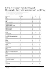
6. C-55 Latest update<br />
The last C-55 update for the region is dated May 2010. A new Region H update has been sent to the<br />
IHB on August 26 th 2013. The C-55 charting and surveying status values regarding Region F areas<br />
under SHOM responsibility are summed up in the following tables:<br />
Depth < 200m Depth > 200m<br />
Survey status<br />
A B C A B C<br />
<strong>France</strong> Méditerranée 95 4 1 95 5 0<br />
F<br />
Monaco (Principauté de) 100 0 0 100 0 0<br />
F<br />
Small ( 100 000)<br />
Charting status<br />
Metric WGS84<br />
A B C A B C A B C<br />
<strong>France</strong> - Méditerranée 100 0 100 100 0 100 80 0 83,6 100 100<br />
Monaco (Principauté de) 1 100 0 100 100 0 100 100 0 100 100 100<br />
Fig. 8: C-55 update values for survey status (top table) and charting status (down table)<br />
1 Data provided by <strong>France</strong> according to FR-MC Technical Agreement signed on September 19th 2005.<br />
9/14
7. Capacity Building Offer of and/or demand for Capacity Building<br />
7.1. Training received, needed, offered<br />
Morocco: <strong>France</strong> has implemented with Morocco a transfer of hydrographic and cartographic<br />
responsibilities mechanism, based on training programmes, consulting and including practical<br />
experience at sea. An agreement has been signed in January 2008 for the period 2008-2013. Since<br />
the last conference, the following trainings have been completed:<br />
Course Year Student<br />
Cat.B Hydrographic course (18 months) 2011 - 2012<br />
2012 - 2013<br />
1<br />
1<br />
Cartographic training course (9 months)<br />
(officer and petty-officer)<br />
2010 - 2011 2<br />
Algeria: An Algerian naval forces petty-officer has completed SHOM’s category B hydrographic<br />
training course at the end of July 2011.<br />
Initial training capabilities provided by SHOM are described in its yearly report available on<br />
www.shom.fr.<br />
7.2. Status of national, bilateral, multilateral or regional development projects with<br />
hydrographic component<br />
Morocco: In the frame of the bilateral agreement signed in 2008 between <strong>France</strong> and Morocco,<br />
SHOM, a limited survey of the harbours of Ksar Sghir and Tanger Ville has been performed in 2011.<br />
Tunisia: A draft agreement for chart coproduction and distribution is under consideration by<br />
Tunisia.<br />
For the countries benefiting from SHOM support to meet the hydrographic services requirements<br />
spelled out by the SOLAS convention, <strong>France</strong> fosters a mechanism of gradual transfer of<br />
responsibilities through State-to-State administrative arrangements. This mechanism relies on<br />
training at SHOM facilities and the formalisation of the respective responsibilities for maritime<br />
safety information, hydrographic and charting activities.<br />
NTR.<br />
7.3. Definition of bids to <strong>IHO</strong>CBC<br />
8. Oceanographic activities<br />
NTR.<br />
8.1. GEBCO/IBC’s activities<br />
8.2. Tide gauge network<br />
Main tide gauge networks in the Mediterranean Sea (RONIM from SHOM, and other partners) are<br />
available on the REFMAR tide gauge webportal, operated by SHOM (http://refmar.shom.fr),<br />
together with the necessary metadata. When possible, raw data are available in near real time.<br />
RONIM tide gauges data are also available on the IOC sea level facility website.<br />
Since the last MBSHC conference, SHOM has installed two new radar tide gauges with real time<br />
transmission in Port Ferréol and Port-La-Nouvelle that contribute to tsunami and storm surge<br />
warning systems.<br />
IGN, University of La Rochelle and SHOM are working together to recover, digitize and analyse sea<br />
level paper records from GLOSS Marseille observatory dating back from 1885. This work is<br />
expected to deliver information on last century sea level rise along the French Mediterranean coast.<br />
10/14
Fig.9: French tide gauges in the Mediterranean Sea.<br />
Green dots are already available on REFMAR website and blue dots are still under progress.<br />
SHOM is encouraging French tide gauge owners to upgrade the quality of their instruments using<br />
radar sensors rather that pressure sensors and developing real time transmissions.<br />
In June 2013, SHOM organized a special meeting “REFMAR days” on sea level to exchange on tide<br />
gauge instruments, data quality an research results on tide modelling, tsunamis and storm surges<br />
warning. Mainly French people have attended to this event, as well as some participants from<br />
countries in Northern and Western Africa.<br />
8.3. New equipment<br />
SHOM released an edition of its tidal<br />
prediction software SHOMAR (for 150<br />
metropolitan <strong>France</strong> harbours and more<br />
than 1 000 overseas and abroad harbours):<br />
Each SHOMAR edition is usable for 2<br />
years. The current version 2013 January<br />
1st, is valuable up to 2014 December, 31st.<br />
SHOMAR software is compatible with<br />
various Windows® operating systems such<br />
as NT, 2000, XP, Vista and Seven.<br />
11/14
In 2012, SHOM’s smartphone application for<br />
tide predictions has been launched for IOS and<br />
Androïd. The user can choose a port, ask for tide<br />
predictions and display the tide graph or moon<br />
phase. For offshore users who do not have<br />
access to Wifi or 3G network, it is possible to<br />
pre-download the one-year tide predictions for<br />
selected ports. A new version of the application,<br />
including 2013 tide predictions, has been<br />
released last March.<br />
8.4. Problems encountered<br />
NTR.<br />
9. Other activities<br />
9.1. Meteorological data collection<br />
NTR.<br />
9.2. Geospatial studies<br />
NTR.<br />
9.3. Disaster prevention<br />
• Tsunami :<br />
Fourteen SHOM tide gauges are contributing to Tsunami warning in the Mediterranean Sea by<br />
broadcasting their sea level data in real time through GTS (Global Telecommunication System)<br />
and also by delivering them directly to the French National Warning Center (CENALT) operated<br />
by CEA.<br />
SHOM participates every year to the French reporting at the North Eastern Atlantic and<br />
Mediterranean Sea Warning System Intergovernmental Coordination Group under Unesco<br />
(NEAMSTWS). French TWS has been delivering official Tsunami Watch messages since July<br />
2012 for North East Atlantic and Western Mediterranean Sea regions.<br />
A lack of real time contributing tide gauge stations on the coasts of Northern Africa is still<br />
reported. Those gauges are missing for an efficient regional tsunami warning system.<br />
• Coastal flooding :<br />
Tide gauges real time transmission can be used for Tsunami warning as well as coastal flooding<br />
warning. In <strong>France</strong>, the French Meteorological office (Météo-<strong>France</strong>) has been operating a storm<br />
surge warning system in collaboration with SHOM since October 2011. Joint efforts are<br />
undertaken to improve storm surge modelling at the coastline using observations, tide<br />
predictions, atmospheric pressure and wind forecasts. A large scale interannual mean sea level<br />
oscillation in the Western Mediterranean Sea is observed, but still not well understood.<br />
• Oil spills:<br />
NTR.<br />
9.4. Environmental protection<br />
NTR.<br />
9.5. Astronomical observations<br />
NTR.<br />
9.6. Magnetic/Gravity surveys<br />
NTR.<br />
9.7. MSDI Progress<br />
12/14
Since 2007 SHOM has undertaken the construction of a spatial data infrastructure through the<br />
INFRAGEOS-H® project which has since then been dealing with the evolution of the hydrographic<br />
databases, and paved the way to metadata management and view web services.<br />
Late 2011, a second SDI step has been launched with the ENTREPOT® project. its objectives<br />
are to identify and distribute non-navigational products and their metadata through a portal based on<br />
web services. This platform also intends to provide specific services like dynamic cartography or<br />
vertical reference information.<br />
At this stage, the SDI construction has achieved the following results:<br />
• Hydrographic databases migration to the new systems is nearly achieved as tide, submarine<br />
cables, wrecks, bathymetry and administrative limits are currently managed in SHOM SDI.<br />
The migration of the last two layers (landmarks and beacons) will take place in September.<br />
• Most products have their metadata written and available on the French geocatalogue<br />
(www.geocatalogue.fr), and the metadata working group created in 2012 is spreading good<br />
practices at SHOM.<br />
• Last January, SHOM opened its maritime and coastal geographic information portal which<br />
offers a large set of view and download services at http://data.shom.fr. All the services are<br />
compliant European directive INSPIRE.<br />
Fig.10: SHOM’s data portal (data.shom.fr)<br />
Two additional services have recently been added to this portal:<br />
• a nautical information feedback service (infonaut.data.shom.fr) which allows all<br />
users to send back to SHOM any information concerning depth, wrecks, coastlines,<br />
buoys, ….<br />
• a dynamic cartographic environment (cartodyn.data.shom.fr) which allows all users<br />
to create their own maps taking benefit from data.shom.fr tools and data.<br />
A detailed description of the portal functions and contents is available on SHOM website<br />
(http://www.shom.fr/les-services-en-ligne/portail-datashomfr/). Data available on that portal are<br />
organised according to the following topics listed below: tides, tidal currents, bathymetry,<br />
cartography, maritime and littoral databases.<br />
9.8. International<br />
<strong>France</strong>, represented by SHOM, is either member or associate member in 9 hydrographic<br />
commissions amongst the 15 organized by the <strong>IHO</strong> members states.<br />
13/14
The detail of SHOM’s involvement in <strong>IHO</strong> activities is listed in the table hereafter:<br />
Name<br />
Chair /<br />
Vice chair<br />
Member<br />
Observations<br />
CBSC<br />
Capacity Building Sub-Committee<br />
CSPCWG<br />
Chart Standardisation and Paper Chart Working Group<br />
DIPWG<br />
Digital Information Portrayal Working Group, former CSMWH<br />
DPSWG<br />
Data Protection Scheme Working Group<br />
DQWG Data Quality Working Group -Last meeting in 1996<br />
EAtHC<br />
FC<br />
GEBCO<br />
HCA<br />
HDWG<br />
HSSC<br />
IRCC<br />
MACHC<br />
MBSHC<br />
MSDIWG<br />
NIOHC<br />
NSHC<br />
RSAHC<br />
SAIHC<br />
SNPWG<br />
SWPHC<br />
TSMAD<br />
TWLWG<br />
WEND<br />
WWNWS<br />
Eastern Atlantic Hydrographic Commission<br />
Vice-chairman of Finance Committee<br />
Joint IOC-<strong>IHO</strong> Guiding Committee for the General Bathymetric Chart of<br />
Oceans (GEBCO<br />
Hydrographic Commission on Antarctica<br />
Hydrographic Dictionary Working Group<br />
Hydrographic Services and Standards Committee, formerly known as the<br />
Committee on Hydrographic Requirements for Information Systems<br />
(CHRIS)<br />
Inter Regional Coordination Committee<br />
MESO American & Caribbean Sea Hydrographic Commission<br />
Mediterranean and Black Seas Hydrographic Commission<br />
Marine Spatial Data Infrastructure Working Group<br />
North Indian Ocean Hydrographic Commission (associate member)<br />
North Sea Hydrographic Commission<br />
ROPME Hydrographic Commission (associate member)<br />
Southern Africa and Islands Hydrographic Commission<br />
Standardisation of Nautical Publications Working Group<br />
South-West Pacific Hydrographic Commission<br />
Transfer Standard Maintenance and Application Development<br />
Tidal and Water Level Working Group<br />
Wold-Wide Electronic Navigational Chart Database<br />
World-wide Navigational Warning Service Sub-Committee, formerly<br />
known as the Promulgation of Radio Navigational Warnings Sub-<br />
Committee (PRNW)<br />
Since the last MBSHC conference, SHOM has kept on contributing the dialogue between European<br />
Hydrographic Offices and the European Commission’s DG-Mare, which resulted in the signature of<br />
a Memorandum of Understanding between the <strong>IHO</strong> and the EC at the opening day of the XVIIIth<br />
International Hydrographic Commission held in Monaco in April 2012. Since then, SHOM has<br />
remain active, coordinating for instance responses on EC’s consultation about its Green Paper on<br />
Marine Knowledge 2020, or more recently by supporting with other nations the build-up of an <strong>IHO</strong>-<br />
EU network during the last IRCC conference in Wollongong (Australia).<br />
10. Conclusions<br />
The future <strong>IHO</strong>-EU network should be made aware of the hydrographic stakes in the region. Coordination<br />
with other multilateral organizations would foster leveraging of resources.<br />
14/14