New Zones of Mineralisation Located at Otjo Project - Shaw River ...
New Zones of Mineralisation Located at Otjo Project - Shaw River ...
New Zones of Mineralisation Located at Otjo Project - Shaw River ...

You also want an ePaper? Increase the reach of your titles
YUMPU automatically turns print PDFs into web optimized ePapers that Google loves.
MARCH 26, 2013<br />
ASX ANNOUNCEMENT<br />
<strong>New</strong> <strong>Zones</strong> <strong>of</strong> Manganese <strong>Mineralis<strong>at</strong>ion</strong><br />
<strong>Loc<strong>at</strong>ed</strong> <strong>at</strong> <strong>Shaw</strong> <strong>River</strong>’s <strong>Otjo</strong> <strong>Project</strong>,<br />
Namibia<br />
HIGHLIGHTS<br />
<br />
<br />
<br />
<strong>Shaw</strong> <strong>River</strong> Manganese Limited (“<strong>Shaw</strong> <strong>River</strong>”)(ASX: SRR) ) is pleased to announce positive results from<br />
recent soil sampling completed <strong>at</strong> its 75.5% owned <strong>Otjo</strong>zondu Manganese <strong>Project</strong> (“<strong>Otjo</strong>”) in Namibia,<br />
which have identified new zones <strong>of</strong> manganese mineralis<strong>at</strong>ion.<br />
Two new zones <strong>of</strong> anomalous manganese-in-soils define areas adjacent and south <strong>of</strong> the Labusrus<br />
Deposit.<br />
Contemporaneous with the <strong>Otjo</strong> <strong>Project</strong> Development Review, <strong>Shaw</strong> <strong>River</strong> is continuing low cost<br />
explor<strong>at</strong>ion via soil sampling, which continues to be successful in unlocking the manganese trend<br />
(“Roper Line”) bene<strong>at</strong>h the Kalahari Sands cover and identifying new explor<strong>at</strong>ion targets for future<br />
drilling.<br />
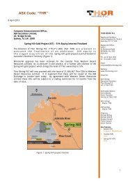
OVERVIEW OF SOIL SAMPLING PROGRAM (Figure 1)<br />
The <strong>Otjo</strong>zondu manganese mineralised horizon (The Roper Line) was mapped in the l<strong>at</strong>e 1950’s<br />
and its position interpreted using outcrop, flo<strong>at</strong> and soil colour. Consequently its position is<br />
approxim<strong>at</strong>e to within 200-300 metres due to being obscured by the Kalahari Sands cover. To<br />
better loc<strong>at</strong>e the Roper Line and prioritise future drilling targets, <strong>Shaw</strong> <strong>River</strong> is continuing to<br />
utilise very low cost explor<strong>at</strong>ion techniques to explore new areas <strong>of</strong> manganese mineralis<strong>at</strong>ion.<br />
<strong>Shaw</strong> <strong>River</strong> has reduced soil sampling grids in areas <strong>of</strong> high priority to increase the resolution <strong>of</strong><br />
potential manganese targets. The sampling technique is quick, cheap and all analysis is<br />
completed on site with a Niton XRF unit*.<br />
*Soil samples are collected and analysed on the explor<strong>at</strong>ion site with a Niton XL2 Series XRF Analyser (Thermo<br />
Scientific) and results were contoured using n<strong>at</strong>ural logs <strong>of</strong> Mn. Warmer colours indic<strong>at</strong>e zones <strong>of</strong> rel<strong>at</strong>ive higher<br />
manganese in soils.<br />
RESULTS (Figures 1 and 2)<br />
o<br />
Soil sampling commenced in 2012 as a method for testing and identifying new target areas <strong>of</strong><br />
manganese mineralis<strong>at</strong>ion under the shallow Kalahari Sands cover. Used in conjunction with<br />
mapping and follow up trenching to expose outcrop and detrital manganese, new areas <strong>of</strong><br />
manganese mineralis<strong>at</strong>ion, covered by Kalahari Sands and associ<strong>at</strong>ed with the historical “Roper<br />
Line” have, following drilling, resulted in new mineral resources, <strong>of</strong>ten with high grade
manganese intercepts. The new Kopje and Jeppe mineral resource are examples (refer to SRR<br />
ASX Release November 12, 2012). Increasing the resolution (closer spaced sampling) over high<br />
priority areas allows the explor<strong>at</strong>ion team to unravel the structures associ<strong>at</strong>ed with the folding <strong>of</strong><br />
the Roper Line.<br />
o<br />
Soil sampling has recently provided very encouraging results from Labusrus South East Area and<br />
Southern Labusrus (see below). The results <strong>of</strong> the soil sampling have elev<strong>at</strong>ed these areas to high<br />
priority drill targets and have the potential to add to the already significant mineral resources<br />
reported <strong>at</strong> nearly Labusrus and S-Bend deposits. (Refer to SRR ASX Release December 11 th<br />
2012).<br />
Figure 1 – Manganese Soil Sampling Areas<br />
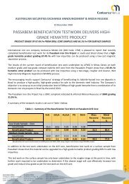
Labusrus South East Area (Figure 2)<br />
Infill soil sampling was conducted south <strong>of</strong> the Labusrus main resource and to the east <strong>of</strong> the S Bend area to<br />
determine the trend <strong>of</strong> the manganese horizon. The area is structurally complex and the sand cover can be in<br />
excess <strong>of</strong> 3 metres.<br />
The results define a 900 metre long, parallel manganese-in-soil anomaly (warm colours) trending east-west,<br />
some 250 metres south <strong>of</strong> the Labusrus line <strong>of</strong> lode and joining with the “S-bend” resource. Initial trenching<br />
was unable to reach through the Kalahari Sands cover which is in excess <strong>of</strong> three meters in this area. This<br />
area may now be considered for follow up trenching and initial drill testing.
Southern Labusrus (Figure 2)<br />
This area is further south <strong>of</strong> the Labusrus “S-bend” Resource and adjacent and east <strong>of</strong> the Purity Manganese<br />
Mining Licence (ML35C). The soil sampling has again successfully identified a 600 metre long, very strong<br />
northerly trending manganese-in-soils zone (warm colours) which has subsequently been trenched by<br />
backhoe confirming the presence <strong>of</strong> manganese mineralised outcrop in two trenches and manganese<br />
detritals in the remaining two other trenches. The l<strong>at</strong>ter is indic<strong>at</strong>ive <strong>of</strong> the very close sp<strong>at</strong>ial presence <strong>of</strong> the<br />
manganese unit.<br />
Figure 2 – Labusrus Area. Contoured manganese-in-soil results (Mn N<strong>at</strong>ural Log)<br />
Coincident with the <strong>Otjo</strong> <strong>Project</strong> development review, <strong>Shaw</strong> <strong>River</strong> will continue to maintain its focus on a low<br />
cost explor<strong>at</strong>ion program <strong>at</strong> <strong>Otjo</strong>, utilising a combin<strong>at</strong>ion <strong>of</strong> soil sampling, rock chip, mapping and trenching<br />
aimed <strong>at</strong> identifying new zones <strong>of</strong> manganese mineralis<strong>at</strong>ion for future drilling.<br />
Peter Benjamin<br />
Managing Director<br />
26 March, 2013<br />
A copy <strong>of</strong> this release can be downloaded from www.shawriver.com.au<br />
Background<br />
<strong>Shaw</strong> <strong>River</strong> Manganese Limited (ASX:SRR) is a manganese explor<strong>at</strong>ion and development company, focused on<br />
exploring and developing its 75.5% owned <strong>Otjo</strong>zondu <strong>Project</strong> in Namibia.<strong>Shaw</strong> <strong>River</strong> has other manganese<br />
explor<strong>at</strong>ion projects <strong>at</strong> Butre in Ghana and Baramine in the East Pilbara Manganese Province <strong>of</strong> Western<br />
Australia. Atlas Iron Limited (ASX:AGO) holds 53.45% <strong>of</strong> <strong>Shaw</strong> <strong>River</strong> Manganese Limited and is a strong<br />
supporter <strong>of</strong> <strong>Shaw</strong> <strong>River</strong>’s manganese str<strong>at</strong>egy.
Forward Looking and Explor<strong>at</strong>ion Target St<strong>at</strong>ements:<br />
Some st<strong>at</strong>ements in this announcement regarding future events are forward-looking st<strong>at</strong>ements. They involve risk and uncertainties th<strong>at</strong> could cause<br />
actual results to differ from estim<strong>at</strong>ed results. Forward-looking st<strong>at</strong>ements include, but are not limited to, st<strong>at</strong>ements concerning the Company’s<br />
explor<strong>at</strong>ion program, outlook, target sizes, resource and mineralized m<strong>at</strong>erial estim<strong>at</strong>es. They include st<strong>at</strong>ements preceded by words such as<br />
“potential”, “target”, “scheduled”, “planned”, “estim<strong>at</strong>e”, “possible”, “future”, “prospective” and similar expressions. The terms “Direct Shipping Ore<br />
(DSO)”, “Target” and “Explor<strong>at</strong>ion Target”, where used in this announcement, should not be misunderstood or misconstrued as an estim<strong>at</strong>e <strong>of</strong> Mineral<br />
Resources and Reserves as defined by the JORC Code (2004), and therefore the terms have not been used in this context. The potential quantity and<br />
grade <strong>of</strong> Explor<strong>at</strong>ion Targets are conceptual in n<strong>at</strong>ure and it is uncertain if further explor<strong>at</strong>ion or feasibility study will result in the determin<strong>at</strong>ion <strong>of</strong> a<br />
Mineral Resource or Reserve.<br />
Competent Person St<strong>at</strong>ement:<br />
The inform<strong>at</strong>ion in this report to which this st<strong>at</strong>ement is <strong>at</strong>tached th<strong>at</strong> rel<strong>at</strong>es to Explor<strong>at</strong>ion Results, is based on inform<strong>at</strong>ion compiled by Mr. Ashley<br />
Jones <strong>of</strong> <strong>Shaw</strong> <strong>River</strong> Manganese Ltd. Mr. Jones is a full-time employee <strong>of</strong> the company, a Member <strong>of</strong> the Australasian Institute <strong>of</strong> Mining and<br />
Metallurgy, and has sufficient experience which is relevant to the style <strong>of</strong> mineraliz<strong>at</strong>ion and type <strong>of</strong> deposit under consider<strong>at</strong>ion and to the activity<br />
which they are undertaking to qualify as Competent Persons as defined in the 2004 Edition <strong>of</strong> the ‘Australasian Code for Reporting <strong>of</strong> Explor<strong>at</strong>ion<br />
Results, Mineral Resources and Ore Reserves’. Mr. Jones consents to the inclusion in the report <strong>of</strong> the m<strong>at</strong>ters based on their inform<strong>at</strong>ion in the form<br />
and context in which it appears.<br />
Figure 3 - Loc<strong>at</strong>ion Diagram <strong>Otjo</strong> Manganese <strong>Project</strong>, Namibia, Walvis Bay Port