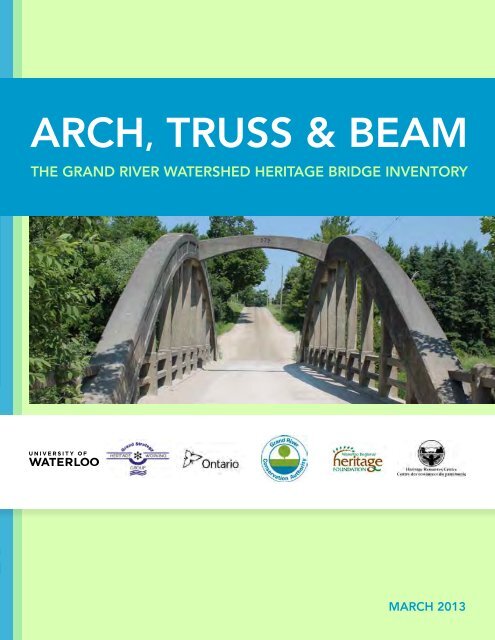
ARCH, TRUSS & BEAM - Grand River Conservation Authority
ARCH, TRUSS & BEAM - Grand River Conservation Authority
ARCH, TRUSS & BEAM - Grand River Conservation Authority

You also want an ePaper? Increase the reach of your titles
YUMPU automatically turns print PDFs into web optimized ePapers that Google loves.
Arch, Truss & Beam<br />
The <strong>Grand</strong> <strong>River</strong> Watershed Heritage Bridge Inventory<br />
March 2013
Arch, Truss & Beam:<br />
The <strong>Grand</strong> <strong>River</strong> Watershed Heritage Bridge Inventory<br />
Prepared By<br />
Lindsay Benjamin, Primary Author, Heritage Resources Centre<br />
Dr. Barbara Veale, Contributing Editor, <strong>Grand</strong> <strong>River</strong> <strong>Conservation</strong> <strong>Authority</strong><br />
Dr. Robert Shipley, Editor, Heritage Resources Centre<br />
Kayla Jonas Galvin, Editor, Heritage Resources Centre<br />
Melissa Davies, Researcher/Writer, Heritage Resources Centre<br />
Funding Provided By<br />
Government of Ontario<br />
<strong>Grand</strong> <strong>River</strong> <strong>Conservation</strong> <strong>Authority</strong><br />
Waterloo Regional Heritage Foundation<br />
March 2013
Arch, Truss & Beam: The <strong>Grand</strong> <strong>River</strong> Watershed Heritage Bridge Inventory<br />
Preface<br />
Bridges – primarily road but also railway– are important cultural features within the <strong>Grand</strong> <strong>River</strong> watershed and<br />
support the national status of the <strong>Grand</strong> <strong>River</strong> and its major tributaries as Canadian Heritage <strong>River</strong>s. Some, such as the<br />
timber covered bridge of West Montrose, are unique survivors of once common designs. A few, such as the massive,<br />
nine-span concrete bowstring bridge across the <strong>Grand</strong> <strong>River</strong> at Caledonia, are visually arresting in their scale and form.<br />
Yet most of the structures in the watershed are “ordinary” steel or concrete bridges. However, close examination can<br />
reveal that they are anything but ordinary in what they can tell us about the past and present. And many, with steel<br />
trusses or concrete arches rising above the land have an aesthetic quality.<br />
Bridges, like people, have finite lives. Increased traffic loads, salt damage, and freeze/thaw cycles are some of the<br />
common factors affecting bridge life. These events are predictable and the loss of key bridges can be planned for.<br />
This is why an inventory, like this one of the <strong>Grand</strong> <strong>River</strong> watershed, is so important. The inventory can highlight<br />
structures before they become a crisis. With pro-active planning it may be possible to reuse the bridge in less strenuous<br />
locations, sympathetically repair rather than replace the bridge, or encourage the design of a new structure to be<br />
of equal visual quality to the one it replaced.<br />
But the inventory is not only for management. For those that have a hankering for old bridges, Arch, Truss & Beam:<br />
The <strong>Grand</strong> <strong>River</strong> Watershed Heritage Bridge Inventory is a gazetteer for anyone that wants to explore the area. You can<br />
discover parts of Ontario and the adjoining resources you never knew existed.<br />
Christopher Andreae, PhD
Heritage Resources Centre<br />
Acknowledgements<br />
This inventory was made possible through the guidance, knowledge, expertise and hard work of a number of groups<br />
and individuals, most notably including:<br />
Government of Ontario for generously funding this project.<br />
<strong>Grand</strong> <strong>River</strong> <strong>Conservation</strong> <strong>Authority</strong> for supporting and funding this work. Special thank you to Dr. Barbara Veale,<br />
Jeff Pitcher and Phil Lenoir.<br />
<strong>Grand</strong> Strategy Heritage Working Group members, specifically: Dr. Barbara Veale, Warren Stauch, Eva Salter, Pat<br />
Salter, Karen Richardson and Jan Liggett for providing invaluable and intimate knowledge of the cultural heritage<br />
resources found throughout the <strong>Grand</strong> <strong>River</strong> watershed.<br />
<strong>Grand</strong> <strong>River</strong> Watershed Heritage Bridge Inventory Steering Committee members: Dr. Barbara Veale, Dr. Robert<br />
Shipley, Karla Barboza, Chris Mahood, Bert Duclos, Dr. Chris Andreae and Kayla Jonas Galvin for guiding the project’s<br />
methodology.<br />
Waterloo Regional Heritage Foundation for their generous support without which the design and printing of this<br />
report would not have been possible.<br />
Lindsay Benjamin for managing, coordinating and publishing this inventory.<br />
Melissa Davies for her invaluable research, photography, and editorial contributions.<br />
Kayla Jonas Galvin for her expertise and editing of this report.<br />
Marg Rowell for her expertise in evaluating cultural heritage resources.<br />
Amy Calder for designing this report.<br />
Toronto and Region <strong>Conservation</strong> <strong>Authority</strong>, Humber Watershed Alliance, Heritage Subcommittee for their<br />
guidance and seminal work, Crossing the Humber: The Humber <strong>River</strong> Heritage Bridge Inventory.<br />
All watershed municipalities and staff members for participating in this inventory and sharing information on the<br />
bridges under their jurisdiction. Such willingness to collaborate ensured the comprehensiveness of this inventory.<br />
Members of the public and local residents who so willing provided information invaluable to the determination<br />
of cultural heritage value of many bridges included in this inventory, including: Pat Mestern, Madelyn Verspagen,<br />
Sharon Anderson, Nathan Holth, Rob Dutton and Sean Young.
Heritage Resources Centre<br />
Table of Contents<br />
Executive Summary ................................................................................................................................................................ 1<br />
Watershed Map ......................................................................................................................................................................... 2<br />
1.0 Introduction ...................................................................................................................................................................... 4<br />
1.1 Background ........................................................................................................................................................ 4<br />
1.2 Project Goals ..................................................................................................................................................... 5<br />
1.3 Evolution of Bridge Building in the <strong>Grand</strong> <strong>River</strong> Watershed ................................................. 6<br />
2.0 Purpose ................................................................................................................................................................................ 8<br />
2.1 Scope of focus ................................................................................................................................................... 9<br />
2.2 Limitations ......................................................................................................................................................... 9<br />
3.0 Methodology .................................................................................................................................................................. 10<br />
3.1 Bridge Identification ................................................................................................................................... 10<br />
3.2 Field Inspection ............................................................................................................................................. 11<br />
3.3 Archival Research ........................................................................................................................................ 12<br />
3.4 Community Knowledge ........................................................................................................................... 12<br />
4.0 Evaluation ........................................................................................................................................................................ 14<br />
Bridge Summaries ................................................................................................................................................ 15<br />
5.0 Results .............................................................................................................................................................................. 356<br />
6.0 Future Opportunities ............................................................................................................................................... 361<br />
7.0 Next Steps ...................................................................................................................................................................... 361<br />
8.0 Conclusion .................................................................................................................................................................... 362<br />
9.0 Bibliography ................................................................................................................................................................. 363<br />
Appendices ............................................................................................................................................................................. 365<br />
Appendix A: Heritage bridge maps by municipality .......................................................................... 366<br />
Appendix B: Field identification form ..................................................................................................... 396<br />
Appendix C: List of non-heritage bridges inventoried .................................................................... 368<br />
Appendix D: Designated bridges ............................................................................................................... 416<br />
Appendix E: Demolished bridges ............................................................................................................... 420<br />
Appendix F: Reconstructed bridges with unique/heritage elements ....................................... 430<br />
Appendix G: General overview of Ontario bridge types ................................................................. 431<br />
Appendix H: Excerpt from the Ontario Heritage Act, Sec. 27 and 29, Part IV ................... 432<br />
Appendix I: Ontario Regulation 9/06 ....................................................................................................... 433
Arch, Truss & Beam: The <strong>Grand</strong> <strong>River</strong> Watershed Heritage Bridge Inventory<br />
Executive Summary<br />
Bridges are an important component of our human heritage, representing an evolution in building materials<br />
and techniques as well as reflecting the aesthetics of the time. Early bridges help to demonstrate the role of rivers<br />
in the industrial and cultural development of Canada. Bridges in the <strong>Grand</strong> <strong>River</strong> watershed act as passageways<br />
through time, providing clues as to how and why local communities and economies developed and evolved.<br />
These remaining heritage bridges should be interpreted, conserved and celebrated as vestiges linking our collective<br />
present to our past.<br />
Heritage bridges represent an endangered species in the 21 st century, with many contemporary issues challenging<br />
conservation efforts. Rural bridges are experiencing capacity issues due to the intensification of agricultural<br />
practices and large new machinery. And with urbanization spreading throughout the watershed in the form of new<br />
residential growth and increasing road networks and capacities, heritage bridges are often ill-equipped to compete<br />
with newer construction techniques in terms of ease of approvals, affordability and load capacity. Newer structures are<br />
not built with an emphasis on design, materials and aesthetics as they once were. Restrictive municipal and<br />
provincial budgets have led to an increasing number of utilitarian bridges crossing the watershed’s rivers, resulting<br />
in an ever-increasing loss of the area’s unique cultural heritage identity.<br />
The <strong>Grand</strong> <strong>River</strong> <strong>Conservation</strong> <strong>Authority</strong> (GRCA), on behalf of watershed municipalities, is the steward of the<br />
Canadian Heritage <strong>River</strong> designation for the <strong>Grand</strong> <strong>River</strong> and its major tributaries and has advocated the need<br />
for a comprehensive inventory of heritage bridges in the watershed for many years. In 2012, the GRCA and the<br />
Heritage Resources Centre at the University of Waterloo formed a partnership to carry out Arch, Truss, Beam:<br />
The <strong>Grand</strong> <strong>River</strong> Watershed Heritage Bridge Inventory. The goal of this study was to support the designation of the<br />
<strong>Grand</strong> <strong>River</strong> and its four tributaries, identify and encourage the listing or designation of bridges with significant cultural<br />
heritage value under the Ontario Heritage Act, as well as promote the unique character and tourism potential of<br />
structures located in each watershed municipality.<br />
To undertake this inventory, the 39 watershed municipalities (seven upper-tier, 26 lower-tier and six single-tier)<br />
and two First Nations were contacted to obtain information on bridges under their jurisdiction. This resulted<br />
in full municipal cooperation in the study. Various provincial, private and community organizations, as well as<br />
local residents were consulted to gather further background research. Maps were reviewed and site visits carried<br />
out to functional and abandoned bridges, as well as abutments. Each bridge that exhibited potential cultural<br />
heritage value was evaluated using the Ontario Heritage Act’s (OHA), Ontario Regulation 9/06: Criteria for determining<br />
cultural heritage value or interest. Of the 678 bridges inventoried, 167 (25%) were found to have heritage value.<br />
As well, 38 demolished structures were identified that were most likely heritage bridges. Additionally, 13 bridges<br />
formally designated under the OHA were identified. Figure 1 illustrates the inventory’s main findings.<br />
This inventory hopes to contribute to the growing<br />
discourse surrounding heritage conservation in<br />
Ontario, while building on the seminal work<br />
undertaken by the Toronto and Region <strong>Conservation</strong><br />
<strong>Authority</strong>, Crossing the Humber: The Humber<br />
<strong>River</strong> Heritage Bridge Inventory. This project<br />
represents the adaptation of the bridge inventory<br />
process as a conservation planning tool to meet the<br />
unique context of the <strong>Grand</strong> <strong>River</strong> watershed: the<br />
largest inland watershed in southwestern Ontario,<br />
comprised of 6,800 km 2 . This tool could be further<br />
adapted by other watersheds to elaborate on the<br />
base of knowledge surrounding the conservation<br />
of Ontario’s heritage bridges.<br />
Figure 1. Summary of inventoried bridges in the <strong>Grand</strong> <strong>River</strong> watershed.<br />
1
Heritage Resources Centre<br />
Watershed Map<br />
2 2
Heritage Resources Centre<br />
1.0 Introduction<br />
The awareness of cultural heritage assets in Canada is growing. Many cities and other municipalities now have<br />
professional planners on staff dealing with heritage issues. Perhaps more importantly, most communities also have<br />
dedicated volunteers working to conserve historic sites.<br />
Both heritage planning professionals and concerned citizens require an ever-increasing amount of reliable<br />
information in order to do their work. When called upon to comment and advise decision makers, heritage experts must<br />
be clear on the values that buildings and sites possess, what might be acceptable changes and which proposals<br />
would compromise the historic value.<br />
Bridges are one class of heritage structures that are particularly important to our understanding of the cultural<br />
landscape around us. Few other types of human built features are as iconic and can be considered landmarks as often<br />
as bridges. In many cases they are the key structures that give character to an area whether rural or urban.<br />
This study is intended to equip heritage advocates with the solid information they need to provide the best advice<br />
possible to decision makers at all levels. We hope that readers find it useful.<br />
Robert Shipley PhD, MCIP, RPP, CAHP<br />
Director, Heritage Resources Centre<br />
1.1 Background<br />
In 1987, the <strong>Grand</strong> <strong>River</strong> <strong>Conservation</strong> <strong>Authority</strong> (GRCA), on behalf of its member municipalities, spearheaded<br />
a participatory process to have the <strong>Grand</strong> <strong>River</strong> and its major tributaries, the Speed, Eramosa, Nith and Conestogo<br />
<strong>River</strong>s, declared Canadian Heritage <strong>River</strong>s (CHR). This status was achieved in 1994 based on outstanding<br />
river-related human heritage and recreational features/values of national significance. The status gives national<br />
recognition to the rivers but carries no regulatory or legal restrictions.<br />
While there is a general awareness throughout the <strong>Grand</strong> <strong>River</strong> watershed that the <strong>Grand</strong> <strong>River</strong> and its major<br />
tributaries are Canadian Heritage <strong>River</strong>s, people are often unaware of the heritage features/values for which this<br />
honour was based. Because many of these features/values are aging and deteriorating, there is significant pressure<br />
on municipalities and landowners to replace them with modern structures (i.e. bridges) or to raze them (i.e. buildings)<br />
to facilitate new development. In many cases, decisions to demolish a heritage structure are made without knowledge<br />
that it is important to the heritage river designation. The creation and perpetuation of this knowledge was the impetus<br />
to inventory the watershed’s heritage resources.<br />
The Heritage <strong>River</strong> Inventory, carried out from 1988-1990 prior to obtaining the designation, initially included only<br />
the 12 heritage bridges identified in the Ontario Heritage Bridge Program (1991). Historic bridges represent one<br />
of the key themes contained in the Cultural Framework for Canadian Heritage <strong>River</strong>s, released in 2000 by<br />
the Canadian Heritage <strong>River</strong>s Board. This framework revealed a significant gap in the Heritage <strong>River</strong> Inventory because<br />
the heritage value of most bridges within the <strong>Grand</strong> <strong>River</strong> watershed had not been formally assessed, leaving<br />
their significance to the heritage river designation undetermined. Concurrently, because of their deteriorating<br />
condition, a growing number of historic bridges throughout the watershed were being replaced. Consequently,<br />
the Heritage Working Group, a group formed in 1995 to promote heritage features and values that support<br />
the Canadian Heritage <strong>River</strong> designation, identified that an update to the Heritage <strong>River</strong> Inventory with a primary focus<br />
on heritage bridges was needed.<br />
In 2003, Robinson Heritage Consulting was retained to undertake a <strong>Grand</strong> <strong>River</strong> Heritage Bridge Inventory (<strong>Grand</strong><br />
Old Bridges) in support of the first decadal Monitoring Report for the <strong>Grand</strong> <strong>River</strong> required for submission<br />
4
Arch, Truss & Beam: The <strong>Grand</strong> <strong>River</strong> Watershed Heritage Bridge Inventory<br />
to the Canadian Heritage <strong>River</strong>s Board in 2004. Given the budget for the project, the inventory work was based<br />
on secondary sources of information; no primary research was carried out. The consultants considered 99<br />
bridges throughout the watershed, most of them along the main stem of the <strong>Grand</strong> <strong>River</strong>. A total of 69 bridges<br />
were considered to have heritage significance, supporting the heritage river designation. Due to the limitations<br />
of the study, the inventory cannot be viewed as a definitive reference on the historic value of all bridge structures<br />
in the <strong>Grand</strong> <strong>River</strong> watershed, as a limited study area was explored. The <strong>Grand</strong> Old Bridges inventory was<br />
supplemented by information obtained through a comprehensive inventory (Spanning the Generations, Phases 1-3)<br />
of heritage bridges in Waterloo Region undertaken by the Regional Municipality of Waterloo in 2004 and 2007.<br />
However, knowledge of historic bridges in other parts of the watershed was still unexplored.<br />
From March 2012 to March 2013 the Heritage Resources Centre (HRC) at the University of Waterloo,<br />
in partnership with the GRCA and the Heritage Working Group, undertook a comprehensive inventory of<br />
heritage bridges within the <strong>Grand</strong> <strong>River</strong> watershed in an effort to inventory and evaluate as many bridges as possible.<br />
This inventory and report has been compiled to support the watershed’s unique river-related heritage as well as<br />
to promote the outstanding structures that should be conserved for future generations and celebrated as cultural relics<br />
of our past accomplishments. The Toronto and Region <strong>Conservation</strong> <strong>Authority</strong>’s ground-breaking inventory, Crossing<br />
the Humber: The Humber <strong>River</strong> Heritage Bridge Inventory (2011), has been used as a template to guide this work.<br />
1.2 Project Goals<br />
An inventory and evaluation of the significance of bridges in the <strong>Grand</strong> <strong>River</strong> watershed has never been carried out,<br />
with the exception of <strong>Grand</strong> Old Bridges and the Region of Waterloo’s Spanning the Generations. This report provides<br />
a comprehensive inventory of bridges in the watershed with the goal of identifying structures with cultural heritage<br />
value eligible for listing or designation under the Ontario Heritage Act. A primary goal of the project was to ensure<br />
that each municipality in the watershed cooperated in providing information on bridges under their jurisdiction;<br />
this was achieved watershed-wide. This inventory should be viewed as an initial step in establishing an ever-evolving<br />
inventory of heritage bridges that can be continuously updated as further information is obtained.<br />
This bridge inventory will provide a planning tool for decision-makers to consult when work associated with a bridge<br />
is contemplated. It will:<br />
• identify whether or not a bridge has heritage significance at both the regional and watershed scales. If deemed<br />
significant, the bridge would be considered an important feature that supports the heritage river designation<br />
for the <strong>Grand</strong> <strong>River</strong> and its major tributaries<br />
• ensure consistency in the criteria and approach used to evaluate bridges across municipalities and build<br />
on the work already completed by the Region of Waterloo<br />
• identify bridges with heritage value to promote appropriate policies and procedures for management of<br />
these assets as set out by the Provincial Policy Statement, the Ontario Heritage Act and guided by the Ontario<br />
Heritage Tool Kit produced by the Ministry of Tourism, Culture & Sport<br />
• identify whether or not a Heritage Impact Assessment (HIA) would be required as part of an Environmental<br />
Assessment (EA) process. If required, the information supplied in this inventory would provide a base for<br />
further research, thereby saving time and expense for the proponent<br />
• provide easily accessible information about the cultural heritage value of a bridge for planners, engineers,<br />
• architects, property owners, municipal heritage committees, developers, the tourism industry, educators<br />
and the interested members of the general public through the GRCA’s <strong>Grand</strong> <strong>River</strong> Information Network<br />
(GRIN) mapping tool, thereby saving time and expense in searching for information<br />
• provide a central element of a municipal cultural plan that begins with mapping local cultural assets and<br />
then leverages these resource for economic development and community building<br />
• foster civic identity and pride by drawing attention to the heritage and development of communities<br />
within the <strong>Grand</strong> <strong>River</strong> watershed<br />
5
Heritage Resources Centre<br />
1.3 Evolution of Bridge Building in the <strong>Grand</strong> <strong>River</strong> Watershed<br />
The history of bridge construction is important to understanding the cultural and developmental evolution of any<br />
area. It has relevance not just locally, but speaks to the development of Canada as a nation. As technological advances<br />
were made, construction techniques improved and life ways were able to advance and adapt to the landscape.<br />
Canadian Heritage <strong>River</strong>s are celebrated for their representation of this evolution not just in settlement patterns<br />
but also in the evolution of building technology, most notably bridges.<br />
The <strong>Grand</strong> <strong>River</strong> and its major tributaries (Nith, Conestogo, Speed, Eramosa), designated Canadian Heritage<br />
<strong>River</strong>s, played a significant role in the settlement of the area. Bridges over these rivers allowed settlers to spread and<br />
communities to develop and thrive. Ingenuity was needed to build structures that could span large watercourses<br />
and handle the unpredictability of flooding and harsh winters. It was this development of technology and innovation<br />
that allows us to trace our past through the bridges that remain today.<br />
First Nations peoples occupied the land of the <strong>Grand</strong> <strong>River</strong> watershed prior to the arrival of the Pennsylvania-Dutch<br />
Mennonite pioneers who settled in the area around 1800. The First Nations’ strong knowledge of the landscape lead<br />
to the identification of areas that allowed for the most accessible means across the watershed’s many streams<br />
and rivers. Often these crossings were fords, such as Brant’s Crossing in the City of Brantford and Doon and Bridgeport<br />
in the City of Kitchener. Today many of these fords are still used as active crossings and archaeological sites remain<br />
at some of the most notable bridges in the watershed, such as the Cayuga Bridge in Haldimand Township.<br />
Following the First Nations’ understanding of the land, Pennsylvania-Dutch Mennonite pioneers began to settle the<br />
area building bridges out of timber at these early crossings. In order to accommodate agricultural land, the settlers<br />
cleared forests, accumulating vast quantities of logs. This resulted in the construction of cheap and efficient timber<br />
bridges. Initially, these timber bridges consisted of two straight logs laid across the stream with smaller boards placed<br />
across to create a deck. These bridges, however, proved ineffective for rivers with larger spans. Therefore, settlers<br />
used their knowledge of building barn roofs and applied it to bridge structures by utilizing king and queen post<br />
trusses in their design. Timber was also used to build crib abutments and piers for bridges with more than one span.<br />
Railway companies introduced more elaborate truss bridges in Ontario around 1850. By this date, numerous truss<br />
designs had been developed. Pratt and Warren trusses, seen throughout the <strong>Grand</strong> <strong>River</strong> watershed, were patented<br />
in 1844 and 1848 respectively. Truss bridges, at the time, were being built using wrought iron due to its functionality<br />
and malleability. Wrought iron bridges were most often found in thriving industrial towns that could afford their<br />
construction. For example, both Brantford and Paris had wrought iron bridges built in the 1870s. Timber bridges<br />
were still extremely popular in Ontario until the 1890s when steel became a more affordable bridge material.<br />
The first steel highway bridges appeared in Ontario around 1885. American steel truss bridges were the first to<br />
become popular in south-western Ontario, including Carnegie Steel from Pittsburgh, Pennsylvania. After 1900,<br />
companies in Hamilton (Hamilton Bridge Company Ltd.) and Walkerville began producing steel for bridge<br />
construction and can be identified to this day by their builder-plates displayed on the ends of bridges.<br />
Steel bridges allowed for larger load limits and continued to be built well into the automobile era. It was common<br />
for these bridges to be built high above the river’s flood plain, as evidenced in several steel truss bridges in the<br />
<strong>Grand</strong> <strong>River</strong> watershed due to its varying flow levels. Steel pony truss bridges were relatively inexpensive and could<br />
be constructed quickly. These bridges are scattered throughout the rural areas of the watershed. Through trusses<br />
were built where a large span was to be crossed, or where large loads were anticipated.<br />
Although steel truss bridges were soon found throughout Ontario, many municipalities still could not afford to<br />
construct them due to the high price of materials. As a result, concrete arch bridges with a simple design, built with local<br />
labour and material, were often a better option for building affordable, yet durable spans in these municipalities. The<br />
first reinforced concrete arch in Ontario was built in 1906. The oldest concrete bridge in the <strong>Grand</strong> <strong>River</strong> watershed is<br />
an earth-filled concrete arch bridge, built in 1908 in the Township of Centre Wellington along the former Fourth Line.<br />
6
Arch, Truss & Beam: The <strong>Grand</strong> <strong>River</strong> Watershed Heritage Bridge Inventory<br />
In 1899, A.W. Campbell, a government instructor in road building, encouraged the use of concrete to provide an<br />
inexpensive, long-lasting bridge material. Concrete became a dominant material for bridge building in southern<br />
Ontario from this time on, as local aggregates were easily accessible for local contractors. Several stone bridges were<br />
also built around the turn of the century, but masonry was not used in excess to build bridges in Ontario due to<br />
the required time, money and skill.<br />
Another concrete design also became significant in this era: the concrete bowstring arch, or concrete truss bridge.<br />
The first of its kind was built over the Etobicoke <strong>River</strong> in 1909. One of the most significant concrete bridge builders<br />
in the <strong>Grand</strong> <strong>River</strong> watershed was Charles Mattaini. He was responsible for many of the concrete bowstring bridges<br />
built between 1903 and 1929 in Wellington County, and several bridges in the Region of Waterloo and Grey<br />
County. Originally from northern Italy where concrete bowstring bridges were common, Mattaini introduced<br />
the design to Ontario and more specifically, the watershed. These single-lane concrete bowstring bridges are of<br />
particular importance to Wellington County, more specifically the Township of Centre Wellington, because of their<br />
age, style and concentration in numbers. These bridges are indicative of the transition from horse-drawn vehicles<br />
to motorized vehicles and farm equipment. They also demonstrate the existence of an organized public works body<br />
as many of these bridges were overseen by Mattaini, but built with local labour and materials. Experimentation<br />
with the bowstring bridge design can be seen throughout the watershed by examining the varying stream sizes<br />
and technical skills. Many of these structures are still in use, proving the durability of this particular design.<br />
However, along with steel truss bridges, they represent the most endangered bridge type in the watershed.<br />
Bowstring bridges are quickly being demolished to make way for larger, increased load bearing structures that can<br />
accommodate two lanes of high-speed traffic.<br />
After 1929, Mattaini gave permission for Barber & Young to use his design. Hired by the Wellington-Guelph County<br />
Council, Barber & Young refined the design and continued to build bowstring bridges both in and outside of the<br />
watershed. Mattaini did not patent or sell the design of these bridges. Instead he chose to leave a legacy in Canada as<br />
thanks for welcoming him and his family. Barber & Young continued to build many noteworthy bowstring bridges<br />
in the watershed, including Kitchener’s five-span Bridgeport Bridge in 1934. Other prominent bridge builders<br />
constructed impressive multi-span bowstring bridges, such as the nine-span Caledonia Bridge constructed by Randolph<br />
MacDonald Co. Ltd. in 1927, and the seven-span Freeport Bridge built by Campbell & Lattimore in 1926.<br />
Simple, solid slab concrete bridges were also favourable during this period, as they were easy to build and ideal for short<br />
spans. Concrete beam bridges were built to cross larger spans. Around 1930, the rigid frame bridge was introduced<br />
and quickly became the favoured design for highway overpasses. This style can be seen dating back to the early 1920s<br />
in the <strong>Grand</strong> <strong>River</strong> watershed, and is a common bridge design still seen today.<br />
World War I caused bridge construction to slow due to reduced labour, money and demand. After the war ended,<br />
there was a spike in personal motorized vehicle use, which meant that larger, stronger bridges needed to be built.<br />
During the Great Depression, bridge construction increased despite an economic downturn. Public works programs<br />
were established to create make-work projects for the unemployed by increasing government work initiatives such<br />
as the construction of many concrete structures in the watershed.<br />
During the period from 1914 to 1930, there were a variety of materials and designs available to those building<br />
bridges. This lead to discussion amongst engineers about the aesthetics of bridge design and how much visual<br />
impact a bridge should have on the surrounding environment. As early as 1911, Professor C.R. Young noted in a paper<br />
read to the Canadian Society of Civil Engineers that there was a lack of attention to the aesthetics in bridge design and<br />
that it reflected “graceless structural outlines, misuses of ornamental features, poor finishes, surface discolouration<br />
and untidy and ill-kept approaches and surroundings” (Cuming, 1983). Also, in 1915, an editorial in The Canadian<br />
Engineer commented on the increased need for aestheticism in bridge designs (Cuming, 1983). Engineers at the<br />
time were described as being too concerned with building bridges from a utilitarian perspective with little care for<br />
the surrounding natural environment. By 1939, engineers and road builders were confident in the visual appeal of<br />
the structures they were building. However, Victor Murray, an assistant engineer with the Ontario Department<br />
7
Heritage Resources Centre<br />
of Highways stated in The Canadian Engineer in 1939 that “a departure from the strictly functional is no longer<br />
considered a sign of weakness” (Cuming, 1983). He continued to state, “a beautifully designed bridge has a certain<br />
value to a community which cannot easily be expressed in dollars, but which pays in the pride that it creates in a<br />
community” (Cuming, 1983). This observation still has relevance today for the many who value the cultural heritage<br />
value of an ascetically appealing bridge.<br />
In 1939, the Second World War caused bridge construction to slow dramatically. Few bridges were built throughout<br />
the province due to high costs and the low availability of labour. After the war, however, bridge construction once<br />
again rapidly increased as part of the ‘building boom.’ Thousands of bridges were constructed and rehabilitated.<br />
Several of these were large projects including bridges on the Trans-Canada Highway and Highway 401. These larger<br />
projects required longer bridges and overpasses. To accommodate these needs, the use of pre-cast and pre-stressed<br />
concrete began to appear and continues to be the most widely used material in bridge construction today.<br />
With the rapid population increase, there was a greater demand for bridge capacity, as well as an increased focus<br />
on safety. The design philosophy in 1965 was based on safety and engineering considerations. The Ontario<br />
Department of Highways stated that “the ideal situation is one where the motorist is unaware he was crossing a<br />
bridge” (Cuming, 1983). This design was implemented by having no part of the bridge projecting above the road deck,<br />
carrying the shoulders of the road across the bridge and by having low, concrete, simple guardrails. Aside from a<br />
few exceptional bridges such as the Burlington Skyway (1958) and several steel through truss bridges built in the<br />
watershed (Fergus, Elora, Drayton) during the 1950s and 1960s, many standardized rigid frame bridges were quickly<br />
built throughout the watershed and the province in an attempt to reach optimum efficiency. This represented<br />
a significant diversion from the sentiments of engineers in the first half of the 20 th century who placed an increasing<br />
value on bridge design and aesthetics. Many of these newer bridges were plain and lacked decoration to reduce<br />
construction time. During this period, any steel, iron or timber bridge that was deemed unsafe and in need of repair<br />
was demolished and quickly rebuilt using this standardized design, resulting in the loss of many of Ontario’s earliest<br />
and most unique structures.<br />
However, there are some extant success stories in the watershed representing designation, rehabilitation and<br />
sympathetic new construction. Brant County has taken commendable strides to conserve the Brant Bowstring<br />
Bridge (B4), the only of its type in the County. Its decision not to demolish the bridge, but rather to designate it,<br />
indicates the active role the County is taking in protecting and preserving its heritage despite development pressure.<br />
Similarly, the Township of East Garafraxa has dedicated significant funds to the rehabilitation of the McPherson<br />
Bridge (EX1), a majestic double bowstring arch (tied) crossing the <strong>Grand</strong> <strong>River</strong>. The City of Guelph has undertaken<br />
the designation of more bridges than any other watershed municipality, with five bridges protected under Part IV<br />
of the Ontario Heritage Act. The Township of Guelph/Eramosa is taking the initiative to rebuild new structures<br />
that reflect the local evolution of bridge design. The character of the area coupled with the designs of original<br />
builders and engineers significant to the community are being reflected. For example, the Eden Mills Bridge<br />
(RGE1) was reconstructed in 1998 to reflect the elegance of the 1913 concrete bowstring arch bridge it replaced.<br />
And Hagan’s Bridge (RGE2), a camelback pony truss structure was constructed in 1995, a rare find so late in the<br />
20 th century. As well, the Region of Waterloo has invested heavily in the rehabilitation of the Freeport Bridge (K1)<br />
and Bridgeport Bridge (K2), ensuring the conservation of these rare multi-span concrete bowstring arch structures<br />
for future generations.<br />
2.0 Purpose<br />
The purpose of this inventory is to:<br />
1. Identify and record as many bridge crossings in the <strong>Grand</strong> <strong>River</strong> watershed as possible regardless of<br />
heritage significance<br />
2. Evaluate each bridge to determine if it possesses significant cultural heritage value<br />
8
Arch, Truss & Beam: The <strong>Grand</strong> <strong>River</strong> Watershed Heritage Bridge Inventory<br />
3. Compile background research on identified heritage bridges that may lead to listing on a municipal<br />
heritage register or designation under the Ontario Heritage Act<br />
4. Support the Canadian Heritage <strong>River</strong> designation for the <strong>Grand</strong> <strong>River</strong> and its major tributaries (Nith,<br />
Conestogo, Speed and Eramosa <strong>River</strong>s)<br />
5. Contribute to cultural mapping efforts throughout the watershed by increasing community<br />
awareness of the significance of heritage bridges, remnants and demolished structures<br />
6. Encourage heritage tourism through cultural planning<br />
7. Contribute to the growing discourse surrounding conservation planning in Ontario<br />
2.1 Scope of focus<br />
This inventory evaluated bridges that cross bodies of water in the <strong>Grand</strong> <strong>River</strong> watershed, including each of the<br />
five Canadian Heritage <strong>River</strong>s (<strong>Grand</strong>, Nith, Speed, Eramosa, Conestogo) and their tributaries. Bridge types recorded<br />
include those that carry vehicles, rail and pedestrians, and may be active, inactive, remnant or demolished<br />
(if information is available). For the most part, remnant bridges included abutments and/or piers. A cut off age of<br />
35 years was decided upon. Although the provincial norm for a resource to be considered heritage is 40 years,<br />
35 years was chosen to provide a broader view of the watershed’s existing and future heritage resources. These structures<br />
may be located on public or private property, and constructed of any material (see Appendix G for a general overview<br />
of Ontario bridge types). Due to the vast area encompassed by the watershed (6,800 km2), culverts were not<br />
evaluated as their numbers proved too numerous. All heritage bridges have been captured with site visits and photographs<br />
and included in an overall bridge inventory database.<br />
Following the example set by the Toronto and Region <strong>Conservation</strong> <strong>Authority</strong>’s (TRCA) award-winning inventory,<br />
Crossing the Humber: The Humber <strong>River</strong> Heritage Bridge Inventory, the definition of “heritage” used to guide<br />
this inventory is “based on the age of a known structure, its uniqueness, rarity, and contribution to community culture<br />
and character” (2011).<br />
2.2 Limitations<br />
Due to the extensive scope of this inventory and the limited temporal and financial resources available, some<br />
limitations were unavoidable. The roadblocks experienced throughout the research process have been included to<br />
aid in streamlining future inventory work.<br />
The necessary reliance on multiple sources to obtain information made it difficult to ensure some bridges were<br />
not missed through human error. For example, failure to attach an Ontario Structural Integrity Management<br />
(OSIM) report for one bridge among many in an email, etc. Of the 678 structures that were inventoried, several<br />
more would have been included if unused roads, private property and rail lines were explored. More bridges<br />
in the Region of Waterloo could also have been identified, however site visits<br />
were not conducted as the Region had been extensively studied in two previous<br />
inventories: <strong>Grand</strong> Old Bridges and Spanning the Generations.<br />
To ensure time remained to visit and inventory unexplored portions of the<br />
watershed, bridge information for the Region of Waterloo was extracted from<br />
It is hoped that further<br />
existing resources.<br />
research on the watershed’s<br />
The collection of archival information was also difficult as most relevant<br />
information is scattered throughout the watershed’s 39 municipalities and two<br />
First Nations, and maintained in varying degrees of organization by a plethora<br />
of archives, groups, societies and committees. Information on builders, architects<br />
and engineers was scarce and would have required a great deal of archival research.<br />
bridges will continue to be<br />
undertaken building on<br />
the methodology and<br />
growing this inventory.<br />
9
Heritage Resources Centre<br />
The inventory’s inclusion of 167 structures did not permit in depth archival research on any one structure, rather<br />
background information on each bridge was provided.<br />
A specific obstacle that hindered the identification and evaluation process was the inability to confirm the exact<br />
construction date of some bridges. The absence of historical records or incomplete maintenance reports contributed<br />
to the necessity of hypothesizing some construction periods. Although the inclusion of this data would have allowed<br />
for more precise evaluations, it is not believed to have negatively impacted the integrity of the inventory.<br />
Locating unknown watercourse names was another obstacle. GRCA GIS staff<br />
provided support in identifying unknown rivers, creeks and streams.<br />
However, many of the smaller watercourses are not formally named,<br />
resulting in an entry of “Unknown” in the inventory’s river crossing section.<br />
It must be stated that this<br />
The determination of an acceptable work plan for a heritage bridge<br />
inventory is not intended to take<br />
requires a case-specific balancing of all concerns. It is hoped that<br />
the place of environmental<br />
this inventory will help to guide decisions that will affect bridges’<br />
and municipal planning processes.<br />
in the future.<br />
This is a first step in evaluating<br />
the watershed’s heritage bridges,<br />
not a definitive and exhaustive list<br />
3.0 Methodology<br />
of all extant heritage bridges or<br />
an account of each structure’s<br />
The methodology of this inventory included five stages of research:<br />
cultural heritage value.<br />
1. Data gathering and bridge identification (sec. 3.1)<br />
2. Field inspections (sec. 3.2)<br />
3. Archival research (sec. 3.3)<br />
4. Community knowledge (sec. 3.4)<br />
5. Evaluation (sec. 4.0)<br />
Note: The methodology and criteria used for evaluation needs to be cognizant of the vast number of bridges found<br />
in this 6,800 km 2 watershed, and the limited time and financial/staff resources available to complete the project.<br />
The information in this report is current as of February 1, 2013.<br />
3.1 Bridge Identification<br />
The goal of this inventory was to identify as many bridges within the <strong>Grand</strong> <strong>River</strong> watershed as possible. A reliance on<br />
mapping and secondary sources of information, along with site visits was the chosen approach to bridge identification.<br />
To identify bridges in the watershed and conduct archival research, the following groups were consulted:<br />
• Municipal and Regional Public Works departments<br />
• Municipal and Regional Planning departments<br />
• Municipal and Regional Engineering Services departments<br />
• Municipal and Regional Roads Superintendents<br />
• Municipal Heritage Committees<br />
• Six Nations of the <strong>Grand</strong> <strong>River</strong> Territory Band Council; Mississaugas of the New Credit Band Council<br />
• Railway companies (Canadian National, Canadian Pacific)<br />
• <strong>Grand</strong> <strong>River</strong> <strong>Conservation</strong> <strong>Authority</strong> (bridge files, HIA reports, EA notices)<br />
• Ministry of Tourism, Culture and Sport (bridge files, HIA reports, EA notices)<br />
• Ministry of Transportation<br />
10
Arch, Truss & Beam: The <strong>Grand</strong> <strong>River</strong> Watershed Heritage Bridge Inventory<br />
• Museums and archives<br />
• Local historic groups and associations<br />
• Local historians<br />
• Local residents<br />
• Historicbridges.org<br />
The resources most vital to the inventory came from municipal, regional and provincial sources, and included:<br />
• Ontario Structural Integrity Management (OSIM) reports<br />
• Municipal Structure Inspection reports<br />
• Previous inventories: Spanning the Generations (2004 & 2007), <strong>Grand</strong> Old Bridges (2004), Township<br />
of Centre Wellington Pilot Bridge Inventory (2009)<br />
The information gathered from these sources was compiled in a database including all identified bridges in the<br />
watershed. The specific data fields include:<br />
• Bridge ID Number<br />
• Heritage Bridge (Yes/No)<br />
• Bridge Name<br />
• Other Names<br />
• Street Location<br />
• Crossing Type (Road, Railway, Pedestrian)<br />
• Road Carried<br />
• <strong>River</strong> Crossed<br />
• Community<br />
• Municipality<br />
• Coordinates (UTM, Zone)<br />
• MTO Site Number<br />
• Owner<br />
• Category Access (Public/Private)<br />
• Original Construction Date<br />
• Construction Date (Circa)<br />
• Significant Dates<br />
• Builder<br />
• Engineer<br />
• Architect<br />
• Bridge Type<br />
• Materials<br />
• Number of Spans<br />
• Number of Lanes<br />
• Road Length (Metres and Feet)<br />
• Road Width (Metres and Feet)<br />
• Load Rating (Tonnes)<br />
• Markings/Distinguishing Features<br />
• Plaques (Local/Provincial/National)<br />
• CHRS Code<br />
• Notes<br />
• Sources<br />
A complete list of all non-heritage bridges recorded in this inventory is provided in Appendix C.<br />
3.2 Field Inspection<br />
Following the first stage of research, 678 bridges were included in the inventory. Information on each structure<br />
was reviewed to determine if a site visit was necessary. Site visits were carried out to bridges with potential cultural<br />
heritage value. This decision was made based on a bridge’s age, construction type, its surrounding context,<br />
recommendations from the public, all in combination with information contained in Ontario Structural Integrity<br />
Management (OSIM) reports obtained from municipalities.<br />
To ensure the watershed was systematically explored, a watershed-wide map was consulted to assist in<br />
dividing the area into more manageable sections. Of the 39 upper, lower and single-tier municipalities and two<br />
First Nations that comprise the watershed, 33 were found to contain bridges requiring field inspections. The remainder<br />
of the municipalities are only partially located in the watershed and were not reported to contain potential heritage<br />
bridges. As a result, they are not referenced in this report or included in the maps provided in Appendix A.<br />
To facilitate the organization of site visits, small-scale maps were created for each municipality and potential<br />
heritage bridges were plotted.<br />
11
Heritage Resources Centre<br />
To guide these site visits, an assessment protocol was created by the project’s Steering Committee. The Committee<br />
was comprised of a diverse group of professionals working in the heritage, environmental and engineering<br />
fields. The assessment protocol included the creation of a ‘Field Identification Form’ (Appendix B) to record site<br />
and bridge specific details, as well as a procedure for photographic documentation. The goal of the Field Identification<br />
Form was to record the location, type, materials, size, context and accessibility of a bridge. Additional factors based<br />
on heritage designation criteria included in Ontario Regulation 9/06 were incorporated into the form to aid<br />
researchers in determining if the bridge warranted further investigation as a candidate heritage bridge. Additional<br />
factors assessed if the bridge was 35 years or older, contributed to a cultural heritage landscape, was a rare survivor,<br />
remnant or unique type.<br />
To determine the existence of railway structures within the watershed, municipal maps were reviewed to locate rail<br />
lines. Bridges that could be accessed via public property were documented. Given time constraints, structures that<br />
proved difficult to access were not included. Information was requested from railway companies, however the resources<br />
received did not facilitate the identification of additional bridges.<br />
Due to the noted time and financial constraints associated with this project, private structures were not exhaustively<br />
researched. However, seven notable bridges were discovered while conducting field inspections of other structures, and<br />
included active and abandoned bridges, along with remnant abutments. The oldest earth-filled concrete arch bridge<br />
(1908) in the watershed was discovered on private property in the Township of Centre Wellington.<br />
The Project Manager, a University of Waterloo co-op student and a Summer Experience Student carried out the assessment<br />
and photography of 367 structures between June and September of 2012. The information gathered was added<br />
to the electronic database to aid in the creation of a short list of bridges with heritage significance. This list represented<br />
structures that merited further archival research and evaluation, to be discussed in Section 4.<br />
3.3 Archival Research<br />
The objective of this inventory was to identify bridges that have potential heritage value and could be listed on<br />
a municipal register or designated following additional research and evaluation. As such, a cursory amount of research<br />
was conducted on each bridge in an effort to examine and include as many structures as possible in the inventory.<br />
Following the data gathering and field inspection stages of research, the compiled short list of bridges with anticipated<br />
heritage significance was further researched. Although information on some structures was not available or did<br />
not exist, museums, archives, heritage committees, libraries, historians and members of the public were consulted<br />
to gather archival information.<br />
3.4 Community Knowledge<br />
Local expertise, knowledge and community networks of the project team were relied upon to supplement archival<br />
research. Through reaching out to colleagues and researching additional suggestions, more site visits were carried<br />
out to newly discovered bridges, and the history of identified bridges grew richer. As well, the knowledge held by<br />
local residents encountered in the field, and their willingness to share their history passed down through generations<br />
of collective memory, further supplemented the research. Four bridges included in the inventory now have more<br />
intricate histories thanks to the insight of residents and property owners.<br />
12
Arch, Truss & Beam: The <strong>Grand</strong> <strong>River</strong> Watershed Heritage Bridge Inventory<br />
4.0 Evaluation<br />
In order to narrow the short list of bridges to a definitive list of heritage structures, evaluation criteria adapted from<br />
Ontario Regulation 9/06: Criteria for determining cultural heritage value or interest was applied (see Appendix I).<br />
The TRCA’s inventory, Crossing the Humber, proved to be an effective test case for the application of these criteria,<br />
and inspired its use in this research.<br />
The adapted criteria contained in Ontario Regulation 9/06 read as follows:<br />
Design/Physical Value<br />
I. Is a rare, unique, representative or early example of a style, type, expression, material or construction<br />
method<br />
II. Displays a high degree of craftsmanship or artistic merit<br />
III. Demonstrates a high degree of technical or scientific achievement<br />
Historic/Associative Value<br />
I. Has direct associations with a theme, event, belief, person, activity, organization, or institution that<br />
is significant to a community<br />
II. Yields, or has the potential to yield, information that contributes to an understanding of a community<br />
or culture<br />
III. Demonstrates or reflects the work or ideas of an architect, artist, engineer, builder, designer or theorist<br />
who is significant to a community<br />
Contextual Value<br />
I. Is important in defining, maintaining or supporting the character of an area<br />
II. Is physically, functionally, visually or historically linked to its surroundings<br />
III. Is a landmark<br />
The criteria were adapted slightly from the original form to incorporate the word “engineer” in the third criteria<br />
under historic/associative value. Due to the nature of bridges, engineers may hold significant associative value as<br />
they directly influence a bridge’s construction, function and appearance.<br />
Following a provision in the Ontario Heritage Act (OHA) in 2005, Ontario<br />
Regulation 9/06 was created. Although previous inventories did not have<br />
the option to evaluate bridges in this way, it now allows for consistent and<br />
objective evaluation criteria, representing a step towards designation under<br />
the OHA.<br />
Upon applying these criteria to heritage bridges with potential cultural<br />
heritage value, 167 heritage bridges and 38 demolished structures were<br />
identified. The extant heritage bridges are comprised of: 160 bridges (one<br />
bridge includes a culvert) and seven abutments (two with piers).<br />
The application<br />
of these criteria is the only<br />
way to effectively encourage<br />
the protection of bridges<br />
and to help municipal staff identify<br />
structures of local and provincial<br />
interest, thus aiding them in<br />
the designation process.<br />
Three bridges in the Township of Guelph/Eramosa were reconstructed to reflect<br />
more traditional heritage bridge types seldom used in contemporary construction.<br />
Their location can be seen on the Township of Guelph/Eramosa map in Appendix A<br />
and brief summaries can be found in the demolished bridge list in Appendix E. This report does not include<br />
a full review and assessment of reconstructed bridges with unique or heritage elements located in the <strong>Grand</strong><br />
<strong>River</strong> watershed. Further study is required in this regard. The three bridges included in Appendix F illustrate<br />
some of the municipal efforts that have been made to design contemporary structures that reflect historic bridge<br />
building aesthetics.<br />
13
Heritage Resources Centre<br />
Although 167 heritage bridges in the <strong>Grand</strong> <strong>River</strong> watershed is a significant number, that figure would have been<br />
higher if not for the demolition and replacement of older, often times deteriorating bridges. Information on<br />
38 demolished, and probable heritage bridges, has been recorded in this inventory (Appendix E).<br />
Many of these structures have been replaced with newer bridges capable of handling increased traffic volumes<br />
and loads or were removed due to deteriorating conditions. The total number of heritage bridges would have also<br />
been significantly higher if culverts were included, along with bridges that span roads and railways.<br />
Each heritage bridge was evaluated against the criteria discussed above. A description, current image and evaluation<br />
of the 167 heritage bridges can be found in the following pages.<br />
14
Arch, Truss & Beam: The <strong>Grand</strong> <strong>River</strong> Watershed Heritage Bridge Inventory<br />
Caledonia Bridge<br />
(Argyle Street North Bridge)<br />
Photograph by Melissa Davies, 2012<br />
General Information<br />
Bridge No. HD1<br />
Ownership: Ministry of Transportation<br />
Construction Date: 1927<br />
Water Crossing: <strong>Grand</strong> <strong>River</strong><br />
Physical Details<br />
Type: Concrete Bowstring Arch<br />
Span: Nine<br />
Dimensions: 200.3m x 2.9m (LxW)<br />
Materials: Reinforced Concrete<br />
15
Heritage Resources Centre<br />
Design/Physical Value<br />
Evaluation Form<br />
I. Is a rare, unique, representative or early example of a style, type, expression, material<br />
or construction method<br />
II. Displays a high degree of craftsmanship or artistic merit<br />
III. Demonstrates a high degree of technical or scientific achievement<br />
Historic/Associative Value<br />
I. Has direct association with a theme, event, belief, person, activity, organization, or institution<br />
that is significant to the community<br />
II. Yields, or has the potential to yield, information that contributes to an understanding<br />
of the community or culture<br />
III. Demonstrates or reflects the work or ideas of an architect, artist, engineer, builder, designer<br />
or theorist who is significant to a community<br />
Contextual Value<br />
I. Is important in defining, maintaining or supporting the character of an area <br />
II. Is physically, functionally, visually or historically linked to its surroundings<br />
III. Is a landmark<br />
Check<br />
<br />
<br />
<br />
<br />
<br />
<br />
<br />
<br />
General Description<br />
The Caledonia Bridge spans the <strong>Grand</strong> <strong>River</strong> on Argyle Street North, between Forfar Street West and Caithness<br />
Street in the town of Caledonia. The property consists of a nine-span concrete bowstring arch bridge that was<br />
constructed in 1927. It is the longest bowstring arch bridge in Ontario and Canada. Due to its outstanding design<br />
and scale, the structure was included on the Ontario Heritage Bridge List in 1990. It is the only remaining concrete<br />
bowstring arch bridge in Haldimand County and one of few remaining examples of this bridge type as the demolition<br />
of similar structures of shorter length have been accelerating in recent years.<br />
The Caledonia Bridge is the fourth permanent bridge to be constructed at this crossing. The first bridge, of crib<br />
and frame construction, was washed away by ice and floods. The second bridge, constructed in 1842, was a 60-foot<br />
(18m) wide, six-span wooden structure reinforced with steel plates. It was constructed to provide permanent and<br />
unimpeded passage to the plank road between Hamilton and Port Dover. After 19 years this structure was also destroyed<br />
by the elements. In 1875, a large and impressive five-span iron Whipple Arch truss bridge was constructed.<br />
This crossing became a toll bridge, and adjacent to the structure a red and buff brick Gothic revival house was built<br />
for the new bridge’s toll keeper. Tolls were collected until about 1890 to help defray the cost of the bridge,<br />
which was roughly $22,500. This former toll house still sits next to the Caledonia Bridge. It has been designated for<br />
its cultural heritage value under Part IV of the Ontario Heritage Act (By-law 655/88).<br />
In 1925, this third bridge on site collapsed under the weight of a truck carrying a load of stone. Following negotiations<br />
between the Provincial government and the County Council, the existing Caledonia Bridge was constructed<br />
in 1927. It was built by the Department of Public Highways of Ontario and Randolph MacDonald Co. Limited,<br />
and was designed by A. B. Crealock, bridge engineer with the Department of Public Works. The bridge’s erection took<br />
five months and was undertaken from June to November of 1927. Its opening was celebrated by the town with<br />
a street dance.<br />
16
Arch, Truss & Beam: The <strong>Grand</strong> <strong>River</strong> Watershed Heritage Bridge Inventory<br />
The Caledonia Bridge is a landmark gateway to the town centre. It provides both a vehicular and pedestrian link<br />
between the residential areas to the south and the commercial core. For those passing through Caledonia<br />
it demarcates the entrance to the community and the exit from it. The arches are graceful with slight indentations.<br />
Pedestrian sidewalks on either side allow for excellent scenic viewing both up and down the <strong>Grand</strong> <strong>River</strong>.<br />
The bridge is a locally recognized heritage asset that contributes to the special character of Caledonia and the<br />
surrounding landscape.<br />
The bridge is part of a group of four multiple-span concrete bowstring arch bridges spanning the <strong>Grand</strong> <strong>River</strong><br />
that were erected in the same time period and in a similar style. These bridges are a part of the upgrading work<br />
that took place to the transportation networks in Ontario, after World War I, to accommodate the increased<br />
number of automobiles. This group includes three bridges within the Region of Waterloo: the Freeport Bridge<br />
and Bridgeport Bridge in the City of Kitchener, and the Main Street Bridge in the City of Cambridge.<br />
Due to the Caledonia Bridge’s deteriorating condition, it underwent short-term repairs in 2008. It is likely that<br />
the bridge will be replaced in 2016 with a wider structure able to accommodate heavy traffic.<br />
Sources:<br />
Historicbridges.org<br />
GRCA Heritage Bridge Inventory<br />
Barbara Martindale<br />
Archaeological Services Inc., Heritage Bridge Impact Assessment, January 2004<br />
17
Heritage Resources Centre<br />
Cayuga Bridge<br />
(<strong>Grand</strong> <strong>River</strong> Bridge)<br />
Photograph by Melissa Davies, 2012<br />
General Information<br />
Bridge No. HD2<br />
Ownership: Haldimand County<br />
Construction Date: 1924<br />
Water Crossing: <strong>Grand</strong> <strong>River</strong><br />
Physical Details<br />
Type: Pratt Through Truss<br />
Span: Five<br />
Dimensions: 190.5m x 8.4m (LxW)<br />
Materials: Steel, Concrete<br />
18
Arch, Truss & Beam: The <strong>Grand</strong> <strong>River</strong> Watershed Heritage Bridge Inventory<br />
Design/Physical Value<br />
Evaluation Form<br />
I. Is a rare, unique, representative or early example of a style, type, expression, material<br />
or construction method<br />
II. Displays a high degree of craftsmanship or artistic merit<br />
III. Demonstrates a high degree of technical or scientific achievement<br />
Historic/Associative Value<br />
I. Has direct association with a theme, event, belief, person, activity, organization, or institution<br />
that is significant to the community<br />
II. Yields, or has the potential to yield, information that contributes to an understanding<br />
of the community or culture<br />
III. Demonstrates or reflects the work or ideas of an architect, artist, engineer, builder, designer<br />
or theorist who is significant to a community<br />
Contextual Value<br />
I. Is important in defining, maintaining or supporting the character of an area <br />
II. Is physically, functionally, visually or historically linked to its surroundings<br />
III. Is a landmark<br />
Check<br />
<br />
<br />
<br />
<br />
<br />
<br />
<br />
<br />
General Description<br />
The Cayuga Bridge is located on Talbot Road (Highway 3) between Maple Road and Ouse Street in the Town<br />
of Cayuga. This bridge is recognized as a rare survivor on a provincial highway of a multi-span through truss steel<br />
bridge. It is an attractive structure that marks the entrance to or exit from Cayuga on the west edge of the community.<br />
The bridge is associated with the Talbot Road, an early road in southwestern Ontario that was taken over by the<br />
Department of Highways in 1920 as part of the development of a provincial highway system. The bridge is the<br />
third structure over the <strong>Grand</strong> <strong>River</strong> in Cayuga and the second at this location. The first bridge (1842) was situated<br />
to the north of the existing bridge and the second bridge (1871) was located on the same alignment as the existing<br />
bridge. The bridge is also situated in a site of archaeological importance. Three time periods are represented on the west<br />
riverbank, and the entire flood plain is an active site. Stage 4 archaeological salvage efforts have recovered ceramics,<br />
tools, and remnants of a historic stone structure.<br />
The Department of Highways under George Hogarth, Chief Engineer, prepared a design for the Cayuga Bridge in<br />
1923. The Department of Highway Annual Report (1925) states that the <strong>Grand</strong> <strong>River</strong> Bridge at Cayuga was completed<br />
in 1924 and replaced “an old iron bridge that was not only unsafe but entirely unsuited to present day traffic” (p. 69).<br />
The Canadian Engineering and Contracting Company constructed the concrete substructure for the sum of $57,000<br />
and the Dominion Bridge Company supplied and erected the steel superstructure for $57,000. The Department<br />
of Highways provided the balance of the work. The total cost of the bridge was $126,600.<br />
The <strong>Grand</strong> <strong>River</strong> Bridge at Cayuga is a five span, steel bridge. The through truss design uses Pratt trusses with parallel<br />
chords. The steel members provided by Carnegie Steel are riveted in place and the steel superstructure is bolted to<br />
concrete piers. On the north side of the bridge, a six-foot wide sidewalk is cantilevered on the outside of the truss with<br />
original lattice railing. Plaques, likely maker’s plaques, located on the end truss at either end of the bridge beside the<br />
sidewalk are visible in historical photographs. However, they appear to have been removed in the early 1970s.<br />
19
Heritage Resources Centre<br />
Repairs to the piers were undertaken in March 1971. An extensive rehabilitation of the bridge took place in 1976<br />
including the installation of a new concrete deck, repair of the truss members, rehabilitation of expansion joints<br />
and bearings and repair of concrete retaining walls, wing walls and abutments. The rehabilitation steel work is<br />
identifiable from the original by the ‘Abitibi’ steel members bolted in place.<br />
The Cayuga Bridge is a rare survivor as few truss bridges remain in use within the Provincial highway system and it<br />
is the only surviving steel through truss bridge on a provincial highway in southwestern Ontario. Only 15 through truss<br />
bridges exist on provincially-owned roads in the Province of Ontario. It is also notable for the number of spans (5),<br />
its total length, concrete piers and walkway on the north side. The structure is visually appealing and contributes to<br />
the character of the surrounding cultural heritage landscape. It is a physical landmark in the Town of Cayuga and acts<br />
as a gateway into and out of the community from the west.<br />
Due to heavy truck traffic the Cayuga Bridge has deteriorated. It is scheduled for replacement by the end of 2013.<br />
Sources:<br />
GRCA Heritage Bridge Inventory<br />
Lacie Williamson (Feb. 8, 2012). The Dunnville Chronicle: “County eager to begin Cayuga bridge construction”<br />
Unterman McPhail Associates. (2005). Heritage Impact Assessment: <strong>Grand</strong> <strong>River</strong> Bridge<br />
20
Arch, Truss & Beam: The <strong>Grand</strong> <strong>River</strong> Watershed Heritage Bridge Inventory<br />
Seneca Bridge<br />
Photograph by Melissa Davies, 2012<br />
General Information<br />
Bridge No. HD3<br />
Ownership: Haldimand County<br />
Construction Date: 1912<br />
Water Crossing: Black Creek<br />
Physical Details<br />
Type: Warren Pony Truss<br />
Span: Single<br />
Dimensions: Unknown<br />
Materials: Linerod Steel<br />
21
Heritage Resources Centre<br />
Design/Physical Value<br />
Evaluation Form<br />
I. Is a rare, unique, representative or early example of a style, type, expression, material<br />
or construction method<br />
II. Displays a high degree of craftsmanship or artistic merit<br />
III. Demonstrates a high degree of technical or scientific achievement<br />
Historic/Associative Value<br />
I. Has direct association with a theme, event, belief, person, activity, organization, or institution<br />
that is significant to the community<br />
II. Yields, or has the potential to yield, information that contributes to an understanding<br />
of the community or culture<br />
III. Demonstrates or reflects the work or ideas of an architect, artist, engineer, builder, designer<br />
or theorist who is significant to a community<br />
Contextual Value<br />
I. Is important in defining, maintaining or supporting the character of an area <br />
II. Is physically, functionally, visually or historically linked to its surroundings<br />
III. Is a landmark<br />
Check<br />
<br />
<br />
<br />
<br />
<br />
<br />
<br />
<br />
General Description<br />
The Seneca Bridge is a small steel and concrete Warren pony truss bridge that crosses Black Creek on <strong>River</strong> Road<br />
(Highway 54) in Seneca Park, Haldimand County. Following the 1912 Good Road Convention’s guidelines, the bridge<br />
was constructed to handle all the road traffic between Caledonia and Cayuga.<br />
The Good Road Convention, at Toronto on May 7, 1912, recommended that all new bridges from 4-40 feet in length<br />
be built with steel beams embedded in concrete for structural stability. Any bridge over 40 feet (12m) in length should<br />
be built solely of steel. The Seneca Bridge, built in 1912, and following these recommendations, has lasted more than<br />
100 years. Though it is no longer in use, the bridge’s steel under supports and decorated side crash walls remain intact.<br />
Constructed by local contractor Melvin Runchey, the bridge stands as a testament to the area’s economic development.<br />
It is also one of very few remaining bridges constructed of Linerod steel.<br />
The Ontario provincial government took over control of <strong>River</strong> Road between Cayuga and Caledonia from the Country,<br />
in or before 1937. At that time, it was renamed Highway 54. The Seneca Bridge handled all traffic between the two<br />
towns from 38 years until 1950 when it was closed and replaced with a larger structure. The Seneca Bridge was designated<br />
for its cultural heritage value under the Ontario Heritage Act in 1984 through Haldimand County By-law 443/84.<br />
Sources:<br />
Canadian Register of Historic Places<br />
GRCA Heritage Bridge Inventory<br />
22
Arch, Truss & Beam: The <strong>Grand</strong> <strong>River</strong> Watershed Heritage Bridge Inventory<br />
York Bridge<br />
(Structure Number 980906)<br />
Photograph by Melissa Davies, 2012<br />
General Information<br />
Bridge No. HD4<br />
Ownership: Haldimand County<br />
Construction Date: 1935<br />
Water Crossing: <strong>Grand</strong> <strong>River</strong><br />
Physical Details<br />
Type: Girders<br />
Span: Four<br />
Dimensions: 166.1m x 8.6m (LxW)<br />
Materials: Steel, Concrete<br />
23
Heritage Resources Centre<br />
Design/Physical Value<br />
Evaluation Form<br />
I. Is a rare, unique, representative or early example of a style, type, expression, material<br />
or construction method<br />
Check<br />
<br />
II. Displays a high degree of craftsmanship or artistic merit<br />
III. Demonstrates a high degree of technical or scientific achievement<br />
Historic/Associative Value<br />
I. Has direct association with a theme, event, belief, person, activity, organization, or institution<br />
that is significant to the community<br />
II. Yields, or has the potential to yield, information that contributes to an understanding<br />
of the community or culture<br />
III. Demonstrates or reflects the work or ideas of an architect, artist, engineer, builder, designer<br />
or theorist who is significant to a community<br />
Contextual Value<br />
I. Is important in defining, maintaining or supporting the character of an area<br />
II. Is physically, functionally, visually or historically linked to its surroundings<br />
III. Is a landmark<br />
<br />
<br />
General Description<br />
The York Bridge is located on Haldimand Road 9, 0.4 km east of <strong>River</strong> Road in the community of York.<br />
This four-span steel girder bridge was built in 1935. It spans the <strong>Grand</strong> <strong>River</strong> upon concrete piers and abutments.<br />
The deck carries two lanes of traffic and is adorned with metal railings. It represents a landmark in the community<br />
of York linking the small commercial centre to the <strong>River</strong> Road, which leads to the nearby Town of Caledonia.<br />
The York Bridge underwent rehabilitation in 2007.<br />
Sources:<br />
Haldimand County Municipal Structure Inspection Forms, 2011, G. Douglas Vallee Limited<br />
Historicbridges.org<br />
24
Arch, Truss & Beam: The <strong>Grand</strong> <strong>River</strong> Watershed Heritage Bridge Inventory<br />
Dunnville Bridge<br />
(Structure Number 980309)<br />
(<strong>Grand</strong> <strong>River</strong> Bridge (Dunnville))<br />
Photograph by Melissa Davies, 2012<br />
General Information<br />
Bridge No. HD5<br />
Ownership: Haldimand County<br />
Construction Date: 1963<br />
Water Crossing: <strong>Grand</strong> <strong>River</strong><br />
Physical Details<br />
Type: I-beam<br />
Span: Eight<br />
Dimensions: 180m x 9.5m (LxW)<br />
Materials: Steel, Concrete<br />
25
Heritage Resources Centre<br />
Design/Physical Value<br />
Evaluation Form<br />
I. Is a rare, unique, representative or early example of a style, type, expression, material<br />
or construction method<br />
Check<br />
<br />
II. Displays a high degree of craftsmanship or artistic merit<br />
III. Demonstrates a high degree of technical or scientific achievement<br />
Historic/Associative Value<br />
I. Has direct association with a theme, event, belief, person, activity, organization, or institution<br />
that is significant to the community<br />
II. Yields, or has the potential to yield, information that contributes to an understanding<br />
of the community or culture<br />
III. Demonstrates or reflects the work or ideas of an architect, artist, engineer, builder, designer<br />
or theorist who is significant to a community<br />
Contextual Value<br />
I. Is important in defining, maintaining or supporting the character of an area<br />
II. Is physically, functionally, visually or historically linked to its surroundings<br />
III. Is a landmark<br />
<br />
<br />
General Description<br />
The Dunnville Bridge is located on Rainham Road (Queen Street), 0.1 km west of Highway 3 (Main Street) in the Town<br />
of Dunnville. This eight-span steel I-beam bridge was constructed in 1963. It crosses the <strong>Grand</strong> <strong>River</strong> and is set upon<br />
concrete piers and abutments. The deck carries two lanes of traffic and metal railings with concrete ends embossed with<br />
decorative horizontal lines.<br />
Bridges have been located at this site since the 1830s when the Welland “feeder” canal was built here. Earlier structures<br />
were of wood construction. The current bridge’s piers are significantly wider than the bridge deck indicating that they<br />
may have previously carried another structure.<br />
The Dunnville Bridge represents a landmark in the area linking the smaller community of Byng to the Town of Dunnville<br />
on the north shore of the <strong>Grand</strong> <strong>River</strong>. The bridge underwent rehabilitation in 1991 and 2011.<br />
Sources:<br />
Haldimand County Municipal Structure Inspection Forms, 2011, G. Douglas Vallee Limited<br />
Haldimand County Museum & Archives<br />
26
Arch, Truss & Beam: The <strong>Grand</strong> <strong>River</strong> Watershed Heritage Bridge Inventory<br />
Caledonia Railway Bridge<br />
Photograph by Melissa Davies, 2012<br />
General Information<br />
Bridge No. HD6<br />
Ownership: Canadian National Railway<br />
Construction Date: 1911<br />
Water Crossing: <strong>Grand</strong> <strong>River</strong><br />
Physical Details<br />
Type: Structural Steel<br />
Span: Eleven<br />
Dimensions: Unknown<br />
Materials: Steel, Masonry, Concrete<br />
27
Heritage Resources Centre<br />
Design/Physical Value<br />
Evaluation Form<br />
I. Is a rare, unique, representative or early example of a style, type, expression, material<br />
or construction method<br />
Check<br />
<br />
II. Displays a high degree of craftsmanship or artistic merit<br />
III. Demonstrates a high degree of technical or scientific achievement<br />
Historic/Associative Value<br />
I. Has direct association with a theme, event, belief, person, activity, organization, or institution<br />
that is significant to the community<br />
II. Yields, or has the potential to yield, information that contributes to an understanding<br />
of the community or culture<br />
III. Demonstrates or reflects the work or ideas of an architect, artist, engineer, builder, designer<br />
or theorist who is significant to a community<br />
Contextual Value<br />
I. Is important in defining, maintaining or supporting the character of an area <br />
II. Is physically, functionally, visually or historically linked to its surroundings<br />
III. Is a landmark<br />
<br />
<br />
<br />
<br />
General Description<br />
The Caledonia Railway Bridge is located 0.7 km west of Argyle St. North in the Town of Caledonia. The Northern &<br />
Northwestern Railway originated this line of track in 1875 and later fell under ownership of the <strong>Grand</strong> Trunk Railway.<br />
The current railway bridge was constructed in 1911 and is now owned by the Canadian National Railway. It still carries<br />
an active rail line through the Town of Caledonia.<br />
The bridge’s eleven-span structural steel frame is set high above the <strong>Grand</strong> <strong>River</strong> on alternating concrete and masonry<br />
piers. It is sited just east of a dam across the <strong>Grand</strong> <strong>River</strong>. Due to the bridge’s physical prominence it acts as a landmark<br />
along the riverscape in the Town of Caledonia, joined by the <strong>Grand</strong> <strong>River</strong> Mill and striking Caledonia bowstring arch<br />
bridge located just south of this structure.<br />
Source:<br />
Andreae, C. (1997). Lines of Country: An atlas of railway and waterway history in Canada<br />
28
Arch, Truss & Beam: The <strong>Grand</strong> <strong>River</strong> Watershed Heritage Bridge Inventory<br />
Cayuga Railway Bridge<br />
Photograph by Melissa Davies, 2012<br />
General Information<br />
Bridge No. HD7<br />
Ownership: Canadian National Railway<br />
Construction Date: 1902<br />
Water Crossing: <strong>Grand</strong> <strong>River</strong><br />
Physical Details<br />
Type: Pratt Deck Truss<br />
Span: Five<br />
Dimensions: Unknown<br />
Materials: Steel, Masonry, Concrete<br />
29
Heritage Resources Centre<br />
Design/Physical Value<br />
Evaluation Form<br />
I. Is a rare, unique, representative or early example of a style, type, expression, material<br />
or construction method<br />
Check<br />
<br />
II. Displays a high degree of craftsmanship or artistic merit<br />
III. Demonstrates a high degree of technical or scientific achievement<br />
Historic/Associative Value<br />
I. Has direct association with a theme, event, belief, person, activity, organization, or institution<br />
that is significant to the community<br />
II. Yields, or has the potential to yield, information that contributes to an understanding<br />
of the community or culture<br />
III. Demonstrates or reflects the work or ideas of an architect, artist, engineer, builder, designer<br />
or theorist who is significant to a community<br />
Contextual Value<br />
I. Is important in defining, maintaining or supporting the character of an area <br />
II. Is physically, functionally, visually or historically linked to its surroundings<br />
III. Is a landmark<br />
<br />
<br />
<br />
<br />
General Description<br />
The Cayuga Railway Bridge is located north of Talbot Road (Highway 3), between Maple Road and Munsee Street<br />
North in the Town of Cayuga. The first railway bridge at this site spanning the <strong>Grand</strong> <strong>River</strong>, built in 1872, was replaced<br />
after an accident on the bridge in 1877. The present bridge was constructed in 1902. The bridge is a five-panel rivetconnected<br />
Pratt deck truss that is set above the <strong>Grand</strong> <strong>River</strong> on four piers of varying design and construction materials.<br />
Some of the piers are composed of decoratively embossed concrete, masonry or a combination of both. It is likely that<br />
the original abutments and piers were built of stone while later rehabilitation efforts resulted in the use of concrete.<br />
The advent of the railways to the towns along the <strong>Grand</strong> <strong>River</strong> drew trade away from the river. The Great Western<br />
Railway began the Canada Air Line as an alternate route to the Canadian Southern Railway. The line ran from Fort<br />
Erie through Welland Junction, Canfield, Tillsonburg and St. Thomas to meet up with the Great Western Railway at<br />
Glencoe. The Cayuga Subdivision between Robbins and St. Thomas opened for traffic in 1873. The rail line ran east to<br />
west along the north side of Cayuga with a station located close to where Munsee Street North (Highway 54) crosses<br />
the rail line. After a series of amalgamations, the line became part of the Canadian National (CN) Railway system in<br />
1923. CN owned this line until it was abandoned in 1996.<br />
The bridge’s physical prominence contributes to the riverscape in the Town of Cayuga, joined by the multi-span Cayuga<br />
Bridge located just south of this structure.<br />
Sources:<br />
Andreae, C. (1997). Lines of Country: An atlas of railway and waterway history in Canada<br />
Historicbridges.org<br />
Unterman McPhail Associates. (2005). Heritage Impact Assessment: <strong>Grand</strong> <strong>River</strong> Bridge<br />
30
Arch, Truss & Beam: The <strong>Grand</strong> <strong>River</strong> Watershed Heritage Bridge Inventory<br />
Former <strong>River</strong> Road Bridge<br />
Photograph by Melissa Davies, 2012<br />
General Information<br />
Bridge No. HD8<br />
Ownership: Unknown<br />
Construction Date: c.1920<br />
Water Crossing: Holmes Creek<br />
Physical Details<br />
Type: Half Through Girders<br />
Span: Single<br />
Dimensions: Unknown<br />
Materials: Concrete<br />
31
Heritage Resources Centre<br />
Design/Physical Value<br />
Evaluation Form<br />
I. Is a rare, unique, representative or early example of a style, type, expression, material<br />
or construction method<br />
Check<br />
<br />
II. Displays a high degree of craftsmanship or artistic merit<br />
III. Demonstrates a high degree of technical or scientific achievement<br />
Historic/Associative Value<br />
I. Has direct association with a theme, event, belief, person, activity, organization, or institution<br />
that is significant to the community<br />
II. Yields, or has the potential to yield, information that contributes to an understanding<br />
of the community or culture<br />
III. Demonstrates or reflects the work or ideas of an architect, artist, engineer, builder, designer<br />
or theorist who is significant to a community<br />
Contextual Value<br />
<br />
I. Is important in defining, maintaining or supporting the character of an area<br />
II. Is physically, functionally, visually or historically linked to its surroundings<br />
<br />
III. Is a landmark<br />
General Description<br />
The former <strong>River</strong> Road Bridge is located parallel to <strong>River</strong> Road, 3.9 km south of Highway 3. It was constructed circa<br />
1920 and is estimated to be one of few early remaining half through girder bridges in Haldimand County. The bridge is<br />
now abandoned and was likely closed to traffic in 1965 when <strong>River</strong> Road was realigned and the current concrete rigid<br />
frame bridge, Structure Number 000017, was built.<br />
There is little information available on this structure. Large stones in the concrete and the impression of thin board<br />
marks used to set the concrete on site indicate that it is of early construction. The bridge exhibits solid concrete railings<br />
embossed with decorative square and rectangular panels, as well as square concrete top caps and pronounced concrete<br />
footings. “Art Gibson 1950” is hand written in one of the concrete of abutments, perhaps indicating a previous rehabilitation<br />
date as the concrete appears newer than the rest of the bridge.<br />
Source:<br />
Haldimand County Municipal Structure Inspection Forms, 2011, G. Douglas Vallee Limited<br />
32
Arch, Truss & Beam: The <strong>Grand</strong> <strong>River</strong> Watershed Heritage Bridge Inventory<br />
Lorne Bridge<br />
(City of Brantford Site Number 125020)<br />
Photograph by Melissa Davies, 2012<br />
General Information<br />
Bridge No. BF1<br />
Ownership: City of Brantford<br />
Construction Date: 1924<br />
Water Crossing: <strong>Grand</strong> <strong>River</strong><br />
Physical Details<br />
Type: Open Spandrel Arch<br />
Span: Three<br />
Dimensions: 133.5m x 22m (LxW)<br />
Materials: Reinforced Concrete<br />
33
Heritage Resources Centre<br />
Design/Physical Value<br />
Evaluation Form<br />
I. Is a rare, unique, representative or early example of a style, type, expression, material<br />
or construction method<br />
II. Displays a high degree of craftsmanship or artistic merit<br />
III. Demonstrates a high degree of technical or scientific achievement<br />
Check<br />
<br />
<br />
Historic/Associative Value<br />
I. Has direct association with a theme, event, belief, person, activity, organization, or institution<br />
that is significant to the community<br />
II. Yields, or has the potential to yield, information that contributes to an understanding<br />
of the community or culture<br />
III. Demonstrates or reflects the work or ideas of an architect, artist, engineer, builder, designer<br />
or theorist who is significant to a community<br />
Contextual Value<br />
I. Is important in defining, maintaining or supporting the character of an area <br />
II. Is physically, functionally, visually or historically linked to its surroundings<br />
III. Is a landmark<br />
<br />
<br />
<br />
<br />
General Description<br />
The Lorne Bridge spans the <strong>Grand</strong> <strong>River</strong> on Colborne Street between Brant Avenue and Icomm Drive in the City of<br />
Brantford. The property consists of a three-span reinforced concrete arch bridge that was constructed in 1924. It is<br />
located on the <strong>Grand</strong> <strong>River</strong> near Brant’s Crossing, a ford representing an historic crossing.<br />
The first bridge on this site was timber and was constructed in 1812. The wooden structure collapsed when the first<br />
team of horses crossed it. Next, an iron bridge was built, but it was destroyed by high waters in 1878. In response, the<br />
original Lorne Bridge was built in 1879, and it was named after the Marquis of Lorne. The Marquis of Lorne, who<br />
served as Governor General of Canada from 1878-1883, helped found the National Art Gallery and married Queen<br />
Victoria’s fourth daughter. Cracks in the first Lorne Bridge necessitated the bridge’s replacement with the current structure,<br />
which was built between 1923 and 1924.<br />
Brantford City Engineer, Frank P. Adams, designed the three-span reinforced concrete arch bridge. The bridge was<br />
constructed by the Port Arthur Construction Company. The Lorne Bridge is a good example of the period when bridge<br />
construction shifted from a reliance on steel to concrete. Adams designed the bridge in concrete because he felt it was<br />
superior to steel. He believed concrete bridges were easier to maintain and were able to display beauty and design more<br />
prominently. Unlike steel, concrete strengthened over time and the material required no painting or rust removal.<br />
The foundation support consists of three identical arches set upon abutments and together these arches span 424 feet<br />
(129m). Between each arch and the super structure are a series of looped braces. The design creates a distinct light<br />
shadow effect.<br />
R.S. Middleton, City Engineer, reconstructed the superstructure in 1980. The reconstruction removed the original<br />
decorative balustrades and improvements were made to the deck. However, the stairs leading from the bridge to Lorne<br />
Park still feature the 1920s decorative open balustrades with thick handrails and tear drop-shaped balusters and flag<br />
masts. A plaque with the city’s crest is located on the north side of the bridge and identifies the construction date and<br />
34
Arch, Truss & Beam: The <strong>Grand</strong> <strong>River</strong> Watershed Heritage Bridge Inventory<br />
individuals, organizations and companies involved in the construction of Lorne Bridge.<br />
The Lorne Bridge spans the <strong>Grand</strong> <strong>River</strong> and is a prominent landmark in Brantford. The northern reaches of the bridge<br />
rest close to the Dufferin Armouries, the neighbouring Lorne Park and Boer War Memorial, along with the nearby<br />
bridges spanning the <strong>Grand</strong> <strong>River</strong>, all of which contribute to the formation of an important cultural heritage landscape<br />
in the City of Brantford.<br />
Sources:<br />
City of Brantford Bridge Appraisal Data<br />
GRCA Heritage Bridge Inventory<br />
Lorne Bridge Designation Report, Heritage Resources Centre, 2009<br />
35
Heritage Resources Centre<br />
T.H. & B. Railway Bridge<br />
Photograph by Melissa Davies, 2012<br />
General Information<br />
Bridge No. BF2<br />
Ownership: City of Brantford<br />
Construction Date: 1890<br />
Water Crossing: <strong>Grand</strong> <strong>River</strong><br />
Physical Details<br />
Type: Half Through Beams<br />
Span: Four<br />
Dimensions: Unknown<br />
Materials: Steel, Timber, Masonry<br />
36
Arch, Truss & Beam: The <strong>Grand</strong> <strong>River</strong> Watershed Heritage Bridge Inventory<br />
Design/Physical Value<br />
Evaluation Form<br />
Check<br />
I. Is a rare, unique, representative or early example of a style, type, expression, material<br />
or construction method<br />
<br />
II. Displays a high degree of craftsmanship or artistic merit<br />
III. Demonstrates a high degree of technical or scientific achievement<br />
Historic/Associative Value<br />
I. Has direct association with a theme, event, belief, person, activity, organization, or institution<br />
that is significant to the community<br />
II. Yields, or has the potential to yield, information that contributes to an understanding<br />
of the community or culture<br />
<br />
<br />
III. Demonstrates or reflects the work or ideas of an architect, artist, engineer, builder, designer<br />
or theorist who is significant to a community<br />
Contextual Value<br />
I. Is important in defining, maintaining or supporting the character of an area <br />
II. Is physically, functionally, visually or historically linked to its surroundings<br />
III. Is a landmark<br />
<br />
General Description<br />
The Toronto, Hamilton and Buffalo Railway (T.H. & B.) Bridge spans the <strong>Grand</strong> <strong>River</strong> between Colborne Street<br />
West and Veterans Memorial Parkway in the City of Brantford. The structure is a four-span steel half through beam<br />
bridge with a timber deck, steel piers and cut stone masonry abutments that was constructed in 1890. “Illinois,<br />
USA” is pressed in the bridges steel beams, indicating the steel was likely sourced from the Illinois Steel Company.<br />
At this time it was the world’s largest steel company and formed in 1889 through the merger of most of the large Chicago-area<br />
mills—including North Chicago, South Works, Union, and Joliet. Importing steel from the USA was<br />
a common occurrence in steel bridge construction in Ontario as the material was easily transported by rail.<br />
The T.H. & B. Railway likely built this bridge. In the 1870s the T.H. & B. Railway was organized as an attempt<br />
to break the stranglehold that the Great Western Railway (G.W.R.) (soon to amalgamate with the <strong>Grand</strong> Trunk<br />
Railway (G.T.R.)), had taken on southern Ontario – specifically the network they had established in and around<br />
Hamilton and Lake Ontario. The T.H. & B.’s first line stretched south from Hamilton to Port Dover, where it linked<br />
with other American lines and was able to successfully divert traffic and business away from the G.W.R. and G.T.R.<br />
The T.H. & B. continued to strike alliances with other companies such as Canadian Pacific. These alliances allowed<br />
the smaller rail line to construct and operate sections of a much larger line owned by a much larger company.<br />
By the late 1890s, the <strong>Grand</strong> Trunk monopoly on southern Ontario had been shattered. Competition began to spring<br />
up all over the area. Small, independent companies followed the example set by the T.H. & B. and made agreements<br />
with larger American companies. The result was a highly competitive market that allowed the Hamilton and Brantford<br />
area to prosper from its strategic central location and proximity to the US border. The Brantford T.H. & B.<br />
Railway station, constructed in 1896, still exists at 60 Market Street South and is located on the City of Brantford’s<br />
heritage inventory.<br />
The bridge has been converted from a railway crossing to pedestrian trail, and now carries the Dike Trail. The T.H.<br />
& B. Railway Bridge is one of four bridges that span the <strong>Grand</strong> <strong>River</strong> in close proximity to Brantford’s downtown.<br />
This bridge contributes to a cultural heritage landscape with the Dike Trail CNR Truss Bridge, Lorne Bridge, Lorne<br />
Park and the designated, Jubilee Terrace Park. This structure and the Dike Trail CNR Truss Bridge both carry the<br />
Dike Trail, part of the larger Gordon Glaves Memorial Pathway.<br />
Sources: Bensman, D. & Wilson, M.W. Iron and Steel. Encyclopedia of Chicago; Hamilton Heritage Structure Assessment, 2002; Andreae, C. (1997).<br />
Lines of Country: An atlas of railway and waterway history in Canada<br />
37
Heritage Resources Centre<br />
Dike Trail CNR Truss Bridge<br />
Photograph by Melissa Davies, 2012<br />
General Information<br />
Bridge No. BF3<br />
Ownership: City of Brantford<br />
Construction Date: c.1920s<br />
Water Crossing: <strong>Grand</strong> <strong>River</strong><br />
Physical Details<br />
Type: Through Truss<br />
Span: Four<br />
Dimensions: Unknown<br />
Materials: Steel, Timber, Concrete<br />
38
Arch, Truss & Beam: The <strong>Grand</strong> <strong>River</strong> Watershed Heritage Bridge Inventory<br />
Evaluation Form<br />
Check<br />
Design/Physical Value<br />
I. Is a rare, unique, representative or early example of a style, type, expression, material<br />
or construction method<br />
<br />
II. Displays a high degree of craftsmanship or artistic merit<br />
III. Demonstrates a high degree of technical or scientific achievement<br />
Historic/Associative Value<br />
I. Has direct association with a theme, event, belief, person, activity, organization, or institution<br />
that is significant to the community<br />
II. Yields, or has the potential to yield, information that contributes to an understanding<br />
of the community or culture<br />
<br />
<br />
III. Demonstrates or reflects the work or ideas of an architect, artist, engineer, builder, designer<br />
or theorist who is significant to a community<br />
Contextual Value<br />
I. Is important in defining, maintaining or supporting the character of an area <br />
II. Is physically, functionally, visually or historically linked to its surroundings<br />
III. Is a landmark<br />
<br />
General Description<br />
The Dike Trail CNR Truss Bridge spans the <strong>Grand</strong> <strong>River</strong> carrying the Dike Trail, 0.3 km south of Colborne Street West<br />
in the City of Brantford. The structure is a four-span steel double through truss bridge with a timber deck and concrete<br />
piers and abutments. It exhibits unusual rolled angles, known as bulb angles, that compose some of the bridge’s built<br />
up members. The use of bulb angles, rather than simple angles, is quite unusual to find on a truss bridge such as this.<br />
The bridge’s two truss spans are very similar but not identical. This could indicate that one span was damaged or<br />
destroyed and replaced at some time. Its date of construction is estimated to be circa the 1920s. This bridge may have<br />
been a part of the <strong>Grand</strong> Trunk Railway carrying a rail line that connected Brantford to southern Ontario and the US.<br />
The Canadian National Railway eventually took over ownership of the track before it was decommissioned in phases.<br />
This structure has been converted to a pedestrian bridge. The original train tracks and ties are still located below<br />
the timber deck, providing context for its original use.<br />
The Dike Trail CNR Truss Bridge is one of four bridges that span the <strong>Grand</strong> <strong>River</strong> in close proximity to Brantford’s<br />
downtown. This bridge contributes to a cultural heritage landscape with the T.H. & B. Railway Bridge, Lorne Bridge,<br />
Lorne Park and the designated, Jubilee Terrace Park. This structure and the T.H. & B. Railway Bridge both carry the<br />
Dike Trail, part of the larger Gordon Glaves Memorial Pathway.<br />
Sources: Andreae, C. Lines of Country: An atlas of railway and waterway history in Canada, 1997<br />
Nathan Holth, 2013<br />
39
Heritage Resources Centre<br />
<strong>Grand</strong> <strong>River</strong> Abutments<br />
Photograph by Melissa Davies, 2012<br />
General Information<br />
Bridge No. BF4<br />
Ownership: n/a<br />
Construction Date: post-1900<br />
Water Crossing: <strong>Grand</strong> <strong>River</strong><br />
Physical Details<br />
Type: Concrete Abutments<br />
Span: n/a<br />
Dimensions: Unknown<br />
Materials: Concrete<br />
40
Arch, Truss & Beam: The <strong>Grand</strong> <strong>River</strong> Watershed Heritage Bridge Inventory<br />
Design/Physical Value<br />
Evaluation Form<br />
I. Is a rare, unique, representative or early example of a style, type, expression, material<br />
or construction method<br />
II. Displays a high degree of craftsmanship or artistic merit<br />
III. Demonstrates a high degree of technical or scientific achievement<br />
Historic/Associative Value<br />
I. Has direct association with a theme, event, belief, person, activity, organization, or institution<br />
that is significant to the community<br />
II. Yields, or has the potential to yield, information that contributes to an understanding<br />
of the community or culture<br />
III. Demonstrates or reflects the work or ideas of an architect, artist, engineer, builder, designer<br />
or theorist who is significant to a community<br />
Contextual Value<br />
I. Is important in defining, maintaining or supporting the character of an area<br />
II. Is physically, functionally, visually or historically linked to its surroundings<br />
III. Is a landmark<br />
Check<br />
<br />
<br />
General Description<br />
The <strong>Grand</strong> <strong>River</strong> Abutments are located on the east and west banks of the <strong>Grand</strong> <strong>River</strong> between Veterans Memorial<br />
Parkway (<strong>Grand</strong> <strong>River</strong> Crossing Bridge) and the T.H. & B. Railway Bridge in the City of Brantford.<br />
It is unknown whether the bridge was a railway or road bridge, but its use of concrete rather than masonry signifies<br />
it was likely constructed after 1900. There are large rocks in the concrete and a thin board finish is still visible, both<br />
features that indicate an early construction date. The abutments are skewed, with the western base located further south<br />
along the <strong>Grand</strong> <strong>River</strong> than the eastern base.<br />
The <strong>Grand</strong> <strong>River</strong> Abutments are located among four bridges that span the <strong>Grand</strong> <strong>River</strong> in close proximity to Brantford’s<br />
downtown. The abutments contribute to a cultural heritage landscape with the T.H. & B. Railway Bridge, Dike Trail<br />
CNR Truss Bridge, Lorne Bridge, Lorne Park and the designated, Jubilee Terrace Park.<br />
41
Heritage Resources Centre<br />
Murray Street Bridge<br />
(City of Brantford Site Number 136010)<br />
Photograph by Melissa Davies, 2012<br />
General Information<br />
Bridge No. BF5<br />
Ownership: City of Brantford<br />
Construction Date: 1921<br />
Water Crossing: Mohawk Waterway<br />
Physical Details<br />
Type: Solid Spandrel Arch<br />
Span: Single<br />
Dimensions: 34.7m x 14.7m (LxW)<br />
Materials: Reinforced Concrete<br />
42
Arch, Truss & Beam: The <strong>Grand</strong> <strong>River</strong> Watershed Heritage Bridge Inventory<br />
Evaluation Form<br />
Check<br />
Design/Physical Value<br />
I. Is a rare, unique, representative or early example of a style, type, expression, material<br />
or construction method<br />
<br />
II. Displays a high degree of craftsmanship or artistic merit<br />
III. Demonstrates a high degree of technical or scientific achievement<br />
Historic/Associative Value<br />
I. Has direct association with a theme, event, belief, person, activity, organization, or institution<br />
that is significant to the community<br />
<br />
<br />
II. Yields, or has the potential to yield, information that contributes to an understanding<br />
of the community or culture<br />
III. Demonstrates or reflects the work or ideas of an architect, artist, engineer, builder, designer<br />
or theorist who is significant to a community<br />
Contextual Value<br />
I. Is important in defining, maintaining or supporting the character of an area <br />
II. Is physically, functionally, visually or historically linked to its surroundings<br />
III. Is a landmark<br />
<br />
General Description<br />
The Murray Street Bridge is located on Murray Street, 0.02 km north of Greenwich Street in the City of Brantford. This solid<br />
spandrel arch was designed by City Engineer Frank P. Adams and built in 1921 over the Brantford Cut of the <strong>Grand</strong> <strong>River</strong><br />
Navigation Company Canal and Lock System (now the Mohawk Waterway). Brantford’s economic development was spurned<br />
by the opening of the <strong>Grand</strong> <strong>River</strong> Navigation Company’s canals that linked Brantford by water to the Welland Canal and<br />
important industrial cities like Buffalo. The Brantford Cut was the final part of the system to be built and opened to great<br />
fanfare in 1848. This canal brought freight and passengers right into Brantford’s downtown and increased trade and attracted<br />
new businesses to the area.<br />
The popularity of solid spandrel bridges was concentrated in the period from 1905 to 1919, and by 1919 there were at least<br />
22 of these bridges with spans over 60 feet (18 m) reported in Ontario. The popularity of the design began to decline by 1919,<br />
although they continued to be built in small numbers into the 1930s. The 60-foot span of the Murray Street Bridge is perhaps<br />
typical of the decorative use of the arch in later years. In the 1920s, open spandrel arches and bowstring bridges tended to<br />
replace the solid spandrel arches for longer spans and concrete beam bridges for shorter spans. This explains Frank P. Adams’<br />
choice to use an open spandrel design for the nearby Lorne Bridge in 1924, just three years after the construction of this solid<br />
spandrel structure.<br />
The bridge is a single span structure of reinforced cast-in-place concrete with an elliptical arch with a smooth soffit. The thin<br />
board finish is still visible in the concrete. Concrete railings with decorative tear-shaped balustrades extend along both sides<br />
of the deck and curve around the corner of Murray Street extending onto Greenwich Street. Designed by Frank P. Adams,<br />
the distinctive Beaux-Arts style balustrade design with cast concrete railing and balusters had been used earlier in the Alfred<br />
Street Bridge, Brantford (pre-1911) and later in the Lorne Bridge, Brantford (1924). In 2003 the original balustrade forms<br />
were used to make replacement balusters during the repair and rehabilitation of the upper level of the bridge.<br />
A city plaque is affixed to the structure commemorating those responsible for its design and construction.<br />
Sources:<br />
City of Brantford Bridge Appraisal Data; GRCA Heritage Bridge Inventory; Cultural Heritage Evaluation Report: Middleport Road Bridge,<br />
Unterman McPhail Associates, January 2010; Karen Dearlove, Activehistory.ca, 2011<br />
43
Heritage Resources Centre<br />
Great Western Railway Bridge<br />
Remnants<br />
Photograph by Melissa Davies, 2012<br />
General Information<br />
Bridge No. B1<br />
Ownership: County of Brant<br />
Construction Date: 1858<br />
Water Crossing: <strong>Grand</strong> <strong>River</strong><br />
Physical Details<br />
Type: Masonry Piers and Abutments<br />
Span: Four<br />
Dimensions: Unknown<br />
Materials: Masonry<br />
44
Arch, Truss & Beam: The <strong>Grand</strong> <strong>River</strong> Watershed Heritage Bridge Inventory<br />
Evaluation Form<br />
Check<br />
Design/Physical Value<br />
I. Is a rare, unique, representative or early example of a style, type, expression, material<br />
or construction method<br />
<br />
II. Displays a high degree of craftsmanship or artistic merit<br />
III. Demonstrates a high degree of technical or scientific achievement<br />
Historic/Associative Value<br />
I. Has direct association with a theme, event, belief, person, activity, organization, or institution<br />
that is significant to the community<br />
II. Yields, or has the potential to yield, information that contributes to an understanding<br />
of the community or culture<br />
<br />
<br />
III. Demonstrates or reflects the work or ideas of an architect, artist, engineer, builder, designer<br />
or theorist who is significant to a community<br />
Contextual Value<br />
I. Is important in defining, maintaining or supporting the character of an area<br />
II. Is physically, functionally, visually or historically linked to its surroundings<br />
III. Is a landmark<br />
<br />
<br />
General Description<br />
The Great Western Railway Bridge remnants are located along the Cambridge to Paris Rail Trail, between West <strong>River</strong><br />
Road South and East <strong>River</strong> Road, parallel with Blue Lake Road.<br />
The bridge deck is gone, but the stone piers and abutments remain. The cut stone piers supported a metal truss<br />
bridge that linked Harrisburg to Paris. The original bridge was built in 1858 and the remaining remnants are<br />
among the oldest in the watershed. The eastern abutment has become the Murray Lookout, a scenic stop along the<br />
Cambridge to Paris Rail Trail owned and maintained by the <strong>Grand</strong> <strong>River</strong> <strong>Conservation</strong> <strong>Authority</strong>. The County of Brant<br />
owns the piers.<br />
Sources:<br />
GRCA Heritage Bridge Inventory<br />
<strong>Grand</strong> Old Bridges Inventory<br />
45
Heritage Resources Centre<br />
Paris Railway Bridge<br />
Photograph by Melissa Davies, 2012<br />
General Information<br />
Bridge No. B2<br />
Ownership: Canadian National Railway<br />
Construction Date: c.1860<br />
Water Crossing: <strong>Grand</strong> <strong>River</strong><br />
Physical Details<br />
Type: Pratt Deck Truss<br />
Span: Three<br />
Dimensions: Unknown<br />
Materials: Steel, Masonry, Concrete<br />
Photograph by Melissa Davies, 2012<br />
46
Arch, Truss & Beam: The <strong>Grand</strong> <strong>River</strong> Watershed Heritage Bridge Inventory<br />
Evaluation Form<br />
Check<br />
Design/Physical Value<br />
I. Is a rare, unique, representative or early example of a style, type, expression, material<br />
or construction method<br />
<br />
II. Displays a high degree of craftsmanship or artistic merit<br />
III. Demonstrates a high degree of technical or scientific achievement<br />
Historic/Associative Value<br />
I. Has direct association with a theme, event, belief, person, activity, organization, or institution<br />
that is significant to the community<br />
II. Yields, or has the potential to yield, information that contributes to an understanding<br />
of the community or culture<br />
<br />
<br />
III. Demonstrates or reflects the work or ideas of an architect, artist, engineer, builder, designer<br />
or theorist who is significant to a community<br />
Contextual Value<br />
I. Is important in defining, maintaining or supporting the character of an area <br />
II. Is physically, functionally, visually or historically linked to its surroundings<br />
III. Is a landmark<br />
<br />
<br />
General Description<br />
The Paris Railway Bridge is located between <strong>Grand</strong> <strong>River</strong> Street North and Willow Street, north of Portland Road and<br />
John Avenue in the Town of Paris. Although the date of construction is unknown, it is likely that the <strong>Grand</strong> Trunk Railway<br />
built this structure circa 1860. It originally carried a line that connected Goderich to Fort Erie and the US border.<br />
Although the <strong>Grand</strong> Trunk line between Paris and Stratford was eventually decommissioned, the bridge is now owned<br />
by the Canadian National Railway and still carries an active rail line through the Town of Paris.<br />
The bridge’s steel truss frame is set high above the <strong>Grand</strong> <strong>River</strong> on concrete and cut stone piers and abutments. Due to<br />
the bridge’s physical prominence it acts as a gateway marking the entrance to and from Paris.<br />
Sources:<br />
GRCA Heritage Bridge Inventory<br />
Andreae, C. Lines of Country: An atlas of railway and waterway history in Canada, 1997<br />
47
Heritage Resources Centre<br />
Nith <strong>River</strong> Bridge<br />
(Structure Number 1-0023-00)<br />
Photograph by Melissa Davies, 2012<br />
General Information<br />
Bridge No. B3<br />
Ownership: County of Brant<br />
Construction Date: 1932<br />
Water Crossing: Nith <strong>River</strong><br />
Physical Details<br />
Type: Solid Spandrel Arch<br />
Span: Two<br />
Dimensions: 35m x 13.4m (LxW)<br />
Materials: Reinforced Concrete<br />
48
Arch, Truss & Beam: The <strong>Grand</strong> <strong>River</strong> Watershed Heritage Bridge Inventory<br />
Evaluation Form<br />
Check<br />
Design/Physical Value<br />
I. Is a rare, unique, representative or early example of a style, type, expression, material<br />
or construction method<br />
II. Displays a high degree of craftsmanship or artistic merit<br />
III. Demonstrates a high degree of technical or scientific achievement<br />
<br />
<br />
Historic/Associative Value<br />
I. Has direct association with a theme, event, belief, person, activity, organization, or institution<br />
that is significant to the community<br />
<br />
II. Yields, or has the potential to yield, information that contributes to an understanding<br />
of the community or culture<br />
III. Demonstrates or reflects the work or ideas of an architect, artist, engineer, builder, designer<br />
or theorist who is significant to a community<br />
<br />
Contextual Value<br />
I. Is important in defining, maintaining or supporting the character of an area <br />
II. Is physically, functionally, visually or historically linked to its surroundings<br />
III. Is a landmark<br />
<br />
General Description<br />
The Nith <strong>River</strong> Bridge is located on <strong>Grand</strong> <strong>River</strong> Street, 0.2 km south of William Street where the <strong>Grand</strong> and Nith <strong>River</strong>s<br />
converge in the Town of Paris. A plaque on the bridge commemorates those responsible for its 1932 construction,<br />
notably Keystone Contractors Ltd. and engineer A.L.S. Nash. This two-span reinforced concrete solid spandrel arch<br />
bridge displays a high degree of artistic merit. It is decorated with false arches, dentils, columns, and a symmetrical<br />
railing system of posts and balustrades. In 2005, portions of the railing were removed.<br />
Pedestrians are welcomed to cross the bridge with ease as sidewalks line both sides of the bridge. The Nith <strong>River</strong> Bridge,<br />
along with the other structures that cross the <strong>Grand</strong> <strong>River</strong> in the Town of Paris, contributes to a valuable cultural heritage<br />
landscape.<br />
Sources: Municipal Structure Inspection Form, County of Brant<br />
GRCA Heritage Bridge Inventory<br />
49
Heritage Resources Centre<br />
Brant Bowstring Bridge<br />
(Fairchild Creek Bridge)<br />
(Starr Bridge)<br />
(Structure Number 1-0065-01)<br />
Photograph by Melissa Davies, 2012<br />
General Information<br />
Bridge No. B4<br />
Ownership: County of Brant<br />
Construction Date: 1931<br />
Water Crossing: Fairchild Creek<br />
Physical Details<br />
Type: Concrete Bowstring Arch<br />
Span: Single<br />
Dimensions: 31m x 7.2m (LxW)<br />
Materials: Reinforced Concrete<br />
50
Arch, Truss & Beam: The <strong>Grand</strong> <strong>River</strong> Watershed Heritage Bridge Inventory<br />
Design/Physical Value<br />
Evaluation Form<br />
I. Is a rare, unique, representative or early example of a style, type, expression, material<br />
or construction method<br />
II. Displays a high degree of craftsmanship or artistic merit<br />
III. Demonstrates a high degree of technical or scientific achievement<br />
Historic/Associative Value<br />
I. Has direct association with a theme, event, belief, person, activity, organization, or institution<br />
that is significant to the community<br />
II. Yields, or has the potential to yield, information that contributes to an understanding<br />
of the community or culture<br />
III. Demonstrates or reflects the work or ideas of an architect, artist, engineer, builder, designer<br />
or theorist who is significant to a community<br />
Contextual Value<br />
I. Is important in defining, maintaining or supporting the character of an area <br />
II. Is physically, functionally, visually or historically linked to its surroundings<br />
III. Is a landmark<br />
Check<br />
<br />
<br />
<br />
<br />
General Description<br />
The Brant Bowstring Bridge spans the <strong>Grand</strong> <strong>River</strong> on Colborne Street East between Brant Avenue in Brantford and<br />
Gilkison Street in the County of Brant. The property consists of a single-span concrete bowstring arch bridge that was<br />
constructed in 1931. The County of Brant designated the bridge in 2006 for its historic and architectural significance<br />
under Part IV of the Ontario Heritage Act (By-law 198-06).<br />
The Brant Bowstring Bridge is the only bowstring arch bridge in the County of Brant. Spanning the <strong>Grand</strong> <strong>River</strong> on<br />
Colborne Street East at the boundary between the City of Brantford and the County of Brant, it serves as a gateway<br />
marker. Built in 1931 of reinforced concrete, it was part of the Ontario Government’s upgrading of transportation<br />
networks after World War I to accommodate the increasing number of automobiles in the area. The bridge’s bowstring<br />
design was popular in the 1920s and 1930s as it required minimal material, was simple to install and could easily accommodate<br />
vehicular traffic.<br />
The Brant Bowstring Bridge, located next to the simple rigid frame Likins Bridge, exhibits decorative concrete railings,<br />
balustrades and deck beams and a sidewalk along the north side. It is considered by some to be the sister bridge to the<br />
Main Street Bridge in Cambridge, which was also constructed in 1931 using the bowstring design. The inclusion of<br />
pedestrian sidewalks is a unique feature of bowstring arch bridges located in urban settings.<br />
The Brant Bowstring Bridge was threatened with demolition by scheduled repair work. However, the Brant Heritage<br />
Committee was successful in presenting the importance of the bridge to Council who in early 2006, subsequently approved<br />
work for rehabilitation at a cost of $1.1 million. In addition to this, Council changed its name from Starr Bridge<br />
to the Brant Bowstring Bridge.<br />
Sources: County of Brant By-law 198-06<br />
Canadian Register of Historic Places<br />
GRCA Heritage Bridge Inventory<br />
Municipal Structure Inspection Form, County of Brant<br />
51
Heritage Resources Centre<br />
Glen Morris Road Bridge<br />
(Structure Number 1-0002-00)<br />
Photograph by Melissa Davies, 2012<br />
General Information<br />
Bridge No. B5<br />
Ownership: County of Brant<br />
Construction Date: c.1854<br />
Water Crossing: Unknown<br />
Physical Details<br />
Type: Earth-filled Masonry Arch<br />
Span: Single, plus culvert<br />
Dimensions: 11.8m x 6.1m (LxW)<br />
Materials: Masonry<br />
52
Arch, Truss & Beam: The <strong>Grand</strong> <strong>River</strong> Watershed Heritage Bridge Inventory<br />
Evaluation Form<br />
Check<br />
Design/Physical Value<br />
I. Is a rare, unique, representative or early example of a style, type, expression, material<br />
or construction method<br />
II. Displays a high degree of craftsmanship or artistic merit<br />
III. Demonstrates a high degree of technical or scientific achievement<br />
Historic/Associative Value<br />
I. Has direct association with a theme, event, belief, person, activity, organization, or institution<br />
that is significant to the community<br />
II. Yields, or has the potential to yield, information that contributes to an understanding<br />
of the community or culture<br />
III. Demonstrates or reflects the work or ideas of an architect, artist, engineer, builder, designer<br />
or theorist who is significant to a community<br />
<br />
<br />
<br />
<br />
<br />
<br />
Contextual Value<br />
I. Is important in defining, maintaining or supporting the character of an area <br />
II. Is physically, functionally, visually or historically linked to its surroundings<br />
III. Is a landmark<br />
<br />
<br />
General Description<br />
The Glen Morris Road Bridge is located on Glen Morris Road East, 0.1 km east of Branchton Road in the Township of<br />
South Dumfries. Constructed circa 1854, this is likely the second oldest bridge remaining in the <strong>Grand</strong> <strong>River</strong> watershed,<br />
after the Mill Creek Bridge (1837) in the City of Cambridge. The Great Western Railway Company constructed<br />
this cut stone bridge over Glen Morris Road East to link Harrisburg with Galt. It is a beautiful example of masonry<br />
work.<br />
The abutments and superstructure are composed of finely tooled, rock-faced stone. The keystone at the centre of each<br />
arch has no date imprint, but is bordered by finely detailed voussoirs. Its unique double arches allow both the road and<br />
a stream to pass under it. Little is known about this structure. The design and craftsmanship point to a pre-confederation<br />
construction date. The age, materials, and design characteristics of the structure contribute greatly to its cultural<br />
heritage value. The Glen Morris Road Bridge includes the only culvert in this heritage bridge inventory and has been<br />
included as an exception due to its unique design and outstanding construction. The Township of South Dumfries<br />
designated this bridge in 1991 under Part IV of the Ontario Heritage Act.<br />
Sources:<br />
Municipal Structure Inspection Form, County of Brant<br />
Brant County Driving Tour, 2009<br />
Hamilton Heritage Bridge Inventory<br />
Ontario Heritage Properties Database<br />
53
Heritage Resources Centre<br />
Mill Street Bridge<br />
(Structure Number 1-0082-00)<br />
Photograph by Melissa Davies, 2012<br />
General Information<br />
Bridge No. B6<br />
Ownership: County of Brant<br />
Construction Date: 1922<br />
Water Crossing: Whiteman Creek<br />
Physical Details<br />
Type: Earth-filled Spandrel Arch<br />
Span: Single<br />
Dimensions: 21.8m x 5.7m (LxW)<br />
Materials: Reinforced Concrete<br />
54
Arch, Truss & Beam: The <strong>Grand</strong> <strong>River</strong> Watershed Heritage Bridge Inventory<br />
Evaluation Form<br />
Check<br />
Design/Physical Value<br />
I. Is a rare, unique, representative or early example of a style, type, expression, material<br />
or construction method<br />
<br />
II. Displays a high degree of craftsmanship or artistic merit<br />
III. Demonstrates a high degree of technical or scientific achievement<br />
Historic/Associative Value<br />
<br />
I. Has direct association with a theme, event, belief, person, activity, organization, or institution<br />
that is significant to the community<br />
II. Yields, or has the potential to yield, information that contributes to an understanding<br />
of the community or culture<br />
III. Demonstrates or reflects the work or ideas of an architect, artist, engineer, builder, designer<br />
or theorist who is significant to a community<br />
Contextual Value<br />
I. Is important in defining, maintaining or supporting the character of an area <br />
II. Is physically, functionally, visually or historically linked to its surroundings<br />
III. Is a landmark<br />
<br />
General Description<br />
The Mill Street Bridge is located on Mill Street, 0.6 km north of Brant County Highway Number 53. The bridge is associated<br />
with the historical theme of the 19 th and 20 th century development of road transportation in the former townships<br />
that now comprise the County of Brant. The bridge was constructed in 1922 and is one of two surviving earthfilled<br />
solid spandrel concrete arch bridges in the County of Brant, joined by the Cleaver Road Bridge.<br />
The Bridge’s early date of construction fits the typical age range, 1905-1919, when this bridge type was popular. Most of<br />
the early activity in concrete bridge construction in Ontario focused on the earth-filled, solid spandrel arch form. The<br />
first arches were semicircular in shape while later developments used an elliptical form to achieve longer spans. The<br />
popularity of solid spandrel bridges, like this one, appears to have declined after 1919, although they continued to be<br />
built in small numbers into the 1930s.<br />
The Mill Street Bridge is a single span, solid spandrel concrete arch structure of reinforced cast-in-place concrete. The<br />
thin board finish is still visible in the concrete. It has an elliptical arch with a smooth soffit. Solid concrete spandrel<br />
walls contain the earth-filled core used to build up the structure to the road deck. Solid concrete railings extend along<br />
both sides of the deck and include decorative features highlighted with recessed panels set between concrete posts. The<br />
bridge is considered a good example of functional engineering design clearly expressing the transfer of loads through<br />
the arch to the abutments. The simple arch design is sculptural in its proportions and shape. No significant modifications<br />
to the bridge have been carried out.<br />
Sources:<br />
Municipal Structure Inspection Form, County of Brant<br />
Cultural Heritage Evaluation Report: Middleport Road Bridge, Unterman McPhail Associates, January 2010<br />
55
Heritage Resources Centre<br />
Cleaver Road Bridge<br />
(Structure Number 1-0083-00)<br />
Photograph by Melissa Davies, 2012<br />
General Information<br />
Bridge No. B7<br />
Ownership: County of Brant<br />
Construction Date: 1922<br />
Water Crossing: Whiteman Creek<br />
Physical Details<br />
Type: Earth-filled Spandrel Arch<br />
Span: Single<br />
Dimensions: 18.8m x 5.5m (LxW)<br />
Materials: Reinforced Concrete<br />
56
Arch, Truss & Beam: The <strong>Grand</strong> <strong>River</strong> Watershed Heritage Bridge Inventory<br />
Evaluation Form<br />
Check<br />
Design/Physical Value<br />
I. Is a rare, unique, representative or early example of a style, type, expression, material<br />
or construction method<br />
<br />
II. Displays a high degree of craftsmanship or artistic merit<br />
III. Demonstrates a high degree of technical or scientific achievement<br />
Historic/Associative Value<br />
<br />
I. Has direct association with a theme, event, belief, person, activity, organization, or institution<br />
that is significant to the community<br />
II. Yields, or has the potential to yield, information that contributes to an understanding<br />
of the community or culture<br />
III. Demonstrates or reflects the work or ideas of an architect, artist, engineer, builder, designer<br />
or theorist who is significant to a community<br />
Contextual Value<br />
I. Is important in defining, maintaining or supporting the character of an area <br />
II. Is physically, functionally, visually or historically linked to its surroundings<br />
III. Is a landmark<br />
<br />
General Description<br />
The Cleaver Road Bridge is located on Cleaver Road, 1.2 km north of Brant County Highway Number 53. The bridge<br />
is associated with the historical theme of the 19 th and 20 th century development of road transportation in the former<br />
townships that now comprise the County of Brant. The bridge was constructed in 1922 and is one of two surviving<br />
earth-filled solid spandrel concrete arch bridges in the County of Brant, joined by the Mill Street Bridge.<br />
The Bridge’s early date of construction fits the typical age range (1905-1919) when this bridge type was popular. Most<br />
of the early activity in concrete bridge construction in Ontario focused on the earth-filled, solid spandrel arch form.<br />
The first arches were semicircular in shape while later developments used an elliptical form to achieve longer spans. The<br />
popularity of solid spandrel bridges appears to have declined after 1919, although they continued to be built in small<br />
numbers into the 1930s.<br />
The Cleaver Road Bridge is a slightly skewed single span, solid spandrel concrete arch structure of reinforced cast-inplace<br />
concrete. The thin board finish is still visible in the concrete. It has an elliptical arch with a smooth soffit. Solid<br />
concrete spandrel walls contain the earth-filled core used to build up the structure to the road deck. Solid concrete railings<br />
extend along both sides of the deck and include decorative features highlighted with recessed panels set between<br />
concrete posts. The ends of the railings are slightly angled outward widening the initial access to the bridge deck. The<br />
bridge is considered a good example of functional engineering design clearly expressing the transfer of loads through<br />
the arch to the abutments. The simple arch design is sculptural in its proportions and shape.<br />
No significant modifications to the bridge have been made over the years. Water Survey of Canada benchmarks are<br />
located on both the southwest and northeast ends of the bridge, one is labeled 0-804-607.<br />
Sources:<br />
Municipal Structure Inspection Form, County of Brant<br />
Cultural Heritage Evaluation Report: Middleport Road Bridge, Unterman McPhail Associates, January 2010<br />
57
Heritage Resources Centre<br />
Burt Road Bridge<br />
(Structure Number 1-0006-00)<br />
Photograph by Melissa Davies, 2012<br />
General Information<br />
Bridge No. B8<br />
Ownership: County of Brant<br />
Construction Date: c.1920<br />
Water Crossing: Fairchild Creek<br />
Physical Details<br />
Type: Pony Truss<br />
Span: Single<br />
Dimensions: 15.9m x 4m (LxW)<br />
Materials: Steel, Reinforced Concrete<br />
58
Arch, Truss & Beam: The <strong>Grand</strong> <strong>River</strong> Watershed Heritage Bridge Inventory<br />
Design/Physical Value<br />
Evaluation Form<br />
I. Is a rare, unique, representative or early example of a style, type, expression, material<br />
or construction method<br />
II. Displays a high degree of craftsmanship or artistic merit<br />
III. Demonstrates a high degree of technical or scientific achievement<br />
Historic/Associative Value<br />
I. Has direct association with a theme, event, belief, person, activity, organization, or institution<br />
that is significant to the community<br />
II. Yields, or has the potential to yield, information that contributes to an understanding<br />
of the community or culture<br />
III. Demonstrates or reflects the work or ideas of an architect, artist, engineer, builder, designer<br />
or theorist who is significant to a community<br />
Contextual Value<br />
I. Is important in defining, maintaining or supporting the character of an area <br />
II. Is physically, functionally, visually or historically linked to its surroundings<br />
III. Is a landmark<br />
Check<br />
<br />
General Description<br />
Burt Road Bridge is located on Burt Road, 0.3 km south of Brant County Highway Number 5 in the community<br />
of South Dumfries. It was constructed circa 1920 and is the only remaining steel truss road bridge in the County<br />
of Brant. The Reaker Bridge, which was of similar construction and estimated to have been built in the same year,<br />
was demolished in late 2012.<br />
Burt Road Bridge is skewed 35 degrees to Fairchild Creek. It is riveted and has a concrete deck and abutments.<br />
The bridge is closed and an approval for demolition was granted in October 2011. However, as of July 2012 it was<br />
still in place.<br />
Sources:<br />
Municipal Structure Inspection Form, County of Brant<br />
GRCA Bridge Environmental Assessment Notices<br />
59
Heritage Resources Centre<br />
Harry Martin Bridge<br />
(Structure Number 1-0080-00)<br />
Photograph by Melissa Davies, 2012<br />
General Information<br />
Bridge No. B9<br />
Ownership: County of Brant<br />
Construction Date: 1955<br />
Water Crossing: Whiteman Creek<br />
Physical Details<br />
Type: T-beam<br />
Span: Single<br />
Dimensions: 30.6m x 8.5m (LxW)<br />
Materials: Reinforced Concrete<br />
Photograph by Melissa Davies, 2012<br />
60
Arch, Truss & Beam: The <strong>Grand</strong> <strong>River</strong> Watershed Heritage Bridge Inventory<br />
Design/Physical Value<br />
Evaluation Form<br />
I. Is a rare, unique, representative or early example of a style, type, expression, material<br />
or construction method<br />
II. Displays a high degree of craftsmanship or artistic merit<br />
III. Demonstrates a high degree of technical or scientific achievement<br />
Historic/Associative Value<br />
I. Has direct association with a theme, event, belief, person, activity, organization, or institution<br />
that is significant to the community<br />
II. Yields, or has the potential to yield, information that contributes to an understanding<br />
of the community or culture<br />
III. Demonstrates or reflects the work or ideas of an architect, artist, engineer, builder, designer<br />
or theorist who is significant to a community<br />
Contextual Value<br />
I. Is important in defining, maintaining or supporting the character of an area <br />
II. Is physically, functionally, visually or historically linked to its surroundings<br />
III. Is a landmark<br />
Check<br />
<br />
<br />
General Description<br />
Harry Martin Bridge is located on Maple Avenue North, 1.5 km north of Brant County Highway Number 53 near the<br />
community of Burford. It was constructed in 1955 and is one of few early T-beam bridges built in the County of Brant<br />
during the 1950s.<br />
This bridge has unique concrete and metal railings that reflect the Art Deco style. The concrete balustrades are embossed<br />
with a series of three lines and the metal balustrades follow a uniformly appealing triangular pattern. The Harry<br />
Martin Bridge contributes to a picturesque setting along Maple Avenue North.<br />
Despite the widespread use of T-beam structures in the United States from the 1920s to the 1960s, there was a more<br />
limited use of this bridge type within Ontario. The concrete rigid frame, introduced in Ontario in the 1930s, continued<br />
to be the dominant bridge type in the province during the 1950s when pre-stressed precast concrete beam and posttension<br />
cast in place structures were introduced in the 1960s. Therefore, the Harry Martin Bridge is a rare and decorative<br />
example of later T-beam bridge construction in the <strong>Grand</strong> <strong>River</strong> watershed.<br />
Sources:<br />
Municipal Structure Inspection Form, County of Brant<br />
Cultural Heritage Evaluation Report, May 2012, Unterman McPhail Associates<br />
61
Heritage Resources Centre<br />
Cunningham Bridge<br />
(Structure Number 1-0130-00)<br />
Photograph by Melissa Davies, 2012<br />
General Information<br />
Bridge No. B10<br />
Ownership: County of Brant<br />
Construction Date: 1962<br />
Water Crossing: McKenzie Creek<br />
Physical Details<br />
Type: Timber<br />
Span: Single<br />
Dimensions: 8.1m x 6.2m (LxW)<br />
Materials: Timber<br />
62
Arch, Truss & Beam: The <strong>Grand</strong> <strong>River</strong> Watershed Heritage Bridge Inventory<br />
Evaluation Form<br />
Check<br />
Design/Physical Value<br />
I. Is a rare, unique, representative or early example of a style, type, expression, material<br />
or construction method<br />
<br />
II. Displays a high degree of craftsmanship or artistic merit<br />
III. Demonstrates a high degree of technical or scientific achievement<br />
Historic/Associative Value<br />
I. Has direct association with a theme, event, belief, person, activity, organization, or institution<br />
that is significant to the community<br />
II. Yields, or has the potential to yield, information that contributes to an understanding<br />
of the community or culture<br />
<br />
III. Demonstrates or reflects the work or ideas of an architect, artist, engineer, builder, designer<br />
or theorist who is significant to a community<br />
Contextual Value<br />
I. Is important in defining, maintaining or supporting the character of an area <br />
II. Is physically, functionally, visually or historically linked to its surroundings<br />
III. Is a landmark<br />
<br />
General Description<br />
The Cunningham Bridge is located on Jenkins Road, 0.2 km west of Cockshutt Road in the community of Oakland.<br />
This is the only wooden bridge remaining in the County of Brant. It is constructed of an undefined vernacular style<br />
and features a timber deck, superstructure, wingwalls, and support logs affixed to the abutments. The bridge is set at a<br />
ten degree skew to McKenzie Creek.<br />
Although little is known about the structure directly, it is apparent that it was named for the Cunningham Family who<br />
settled at East Oakland at the turn of the 19 th century and remained on the site for generations. Although a bridge<br />
inspection report from 1985 indicates the bridge was constructed in 1962, it is likely it was constructed much earlier,<br />
perhaps in the late-19th to early-20th century. Access across McKenzie Creek at this site would have been necessary for<br />
the Cunningham’s who farmed the area and for those attending the school located on Cunningham’s property, which<br />
was operational from 1862 to 1965. A flour mill was also located along Jenkins Road at the East Oakland Pond, further<br />
necessitating a bridge at this crossing. Local knowledge indicates there was a structure here as far back as 1935. Plans<br />
for a proposed steel bridge at this site also date to 1935. It is possible the bridge was constructed of timber rather than<br />
steel.<br />
The Cunningham Bridge underwent rehabilitation efforts in 2011. Photographs from 1968 indicate the structure once<br />
had white painted wooden railings. They have since been removed and replaced with a concrete barrier wall that obscures<br />
any view of the structure with the exception of the timber deck.<br />
Sources:<br />
Municipal Structure Inspection Form, County of Brant<br />
Oakland History Volume 1, 2 and 4<br />
63
Heritage Resources Centre<br />
John Leishman Bridge<br />
(Structure Number 1-0081-00)<br />
Photograph by Melissa Davies, 2012<br />
General Information<br />
Bridge No. B11<br />
Ownership: County of Brant<br />
Construction Date: 1956<br />
Water Crossing: Whiteman Creek<br />
Physical Details<br />
Type: I-beam<br />
Span: Four<br />
Dimensions: 36.8m x 8.8m (LxW)<br />
Materials: Steel, Reinforced Concrete<br />
64
Arch, Truss & Beam: The <strong>Grand</strong> <strong>River</strong> Watershed Heritage Bridge Inventory<br />
Design/Physical Value<br />
Evaluation Form<br />
I. Is a rare, unique, representative or early example of a style, type, expression, material<br />
or construction method<br />
II. Displays a high degree of craftsmanship or artistic merit<br />
III. Demonstrates a high degree of technical or scientific achievement<br />
Historic/Associative Value<br />
I. Has direct association with a theme, event, belief, person, activity, organization, or institution<br />
that is significant to the community<br />
II. Yields, or has the potential to yield, information that contributes to an understanding<br />
of the community or culture<br />
III. Demonstrates or reflects the work or ideas of an architect, artist, engineer, builder, designer<br />
or theorist who is significant to a community<br />
Contextual Value<br />
I. Is important in defining, maintaining or supporting the character of an area <br />
II. Is physically, functionally, visually or historically linked to its surroundings<br />
III. Is a landmark<br />
Check<br />
<br />
<br />
General Description<br />
John Leishman Bridge is located on Bishops Gate Road, 1.5 km north of Brant County Highway Number 53 near the<br />
community of Burford. Constructed in 1956, it is the oldest I-beam structure in the County of Brant. Its early construction<br />
date sets it apart from the numerous other I-beam bridges in the County.<br />
Plaques commemorating those responsible for the construction of John Leishman Bridge are located on opposite sides<br />
of the bridge’s simple concrete railings. Specifically, the plaque pays homage to County Engineer, R.M. Lee and John<br />
Leishman, the Road Foreman and bridge’s namesake.<br />
John Leishman Bridge underwent repairs in 1998.<br />
Source:<br />
Municipal Structure Inspection Form, County of Brant<br />
65
Heritage Resources Centre<br />
<strong>Grand</strong> <strong>River</strong> Bridge<br />
(Structure Number 1-0024-00)<br />
Photograph by Melissa Davies, 2012<br />
General Information<br />
Bridge No. B12<br />
Ownership: County of Brant<br />
Construction Date: 1967<br />
Water Crossing: <strong>Grand</strong> <strong>River</strong><br />
Physical Details<br />
Type: I-beam<br />
Span: Five<br />
Dimensions: 120m x 9.1m (LxW)<br />
Materials: Steel, Reinforced Concrete<br />
66
Arch, Truss & Beam: The <strong>Grand</strong> <strong>River</strong> Watershed Heritage Bridge Inventory<br />
Evaluation Form<br />
Check<br />
Design/Physical Value<br />
I. Is a rare, unique, representative or early example of a style, type, expression, material<br />
or construction method<br />
<br />
II. Displays a high degree of craftsmanship or artistic merit<br />
III. Demonstrates a high degree of technical or scientific achievement<br />
Historic/Associative Value<br />
I. Has direct association with a theme, event, belief, person, activity, organization, or institution<br />
that is significant to the community<br />
II. Yields, or has the potential to yield, information that contributes to an understanding<br />
of the community or culture<br />
III. Demonstrates or reflects the work or ideas of an architect, artist, engineer, builder, designer<br />
or theorist who is significant to a community<br />
Contextual Value<br />
I. Is important in defining, maintaining or supporting the character of an area <br />
II. Is physically, functionally, visually or historically linked to its surroundings<br />
III. Is a landmark<br />
<br />
General Description<br />
The <strong>Grand</strong> <strong>River</strong> Bridge is located on Dundas Street East, 1.1 km west of Paris Road in the Town of Paris.<br />
The bridge crosses both the <strong>Grand</strong> <strong>River</strong> and Ball Street and is prominent feature in the view along the <strong>Grand</strong> <strong>River</strong> in<br />
the Town of Paris. It is located slightly south of the now demolished Willow Street Bridge, a wrought iron truss bridge<br />
constructed in 1877 and removed in 1988.<br />
Constructed in 1967, the <strong>Grand</strong> <strong>River</strong> Bridge is slightly skewed and set upon unique concrete piers<br />
and decoratively arched and painted steel I-beams. The railings are simple and constructed of concrete and metal. The<br />
<strong>Grand</strong> <strong>River</strong> Bridge underwent repairs in 2005 and 2009.<br />
Source:<br />
Municipal Structure Inspection Form, County of Brant<br />
67
Heritage Resources Centre<br />
William Street Bridge<br />
(Structure Number 1-0159-00)<br />
Photograph by Melissa Davies, 2012<br />
General Information<br />
Bridge No. B13<br />
Ownership: County of Brant<br />
Construction Date: 1968<br />
Water Crossing: <strong>Grand</strong> <strong>River</strong><br />
Physical Details<br />
Type: I-beam<br />
Span: Four<br />
Dimensions: 110.5m x 11m (LxW)<br />
Materials: Steel, Reinforced Concrete<br />
Photograph by Melissa Davies, 2012<br />
68
Arch, Truss & Beam: The <strong>Grand</strong> <strong>River</strong> Watershed Heritage Bridge Inventory<br />
Evaluation Form<br />
Check<br />
Design/Physical Value<br />
I. Is a rare, unique, representative or early example of a style, type, expression, material<br />
or construction method<br />
II. Displays a high degree of craftsmanship or artistic merit<br />
III. Demonstrates a high degree of technical or scientific achievement<br />
<br />
Historic/Associative Value<br />
I. Has direct association with a theme, event, belief, person, activity, organization, or institution<br />
that is significant to the community<br />
II. Yields, or has the potential to yield, information that contributes to an understanding<br />
of the community or culture<br />
<br />
III. Demonstrates or reflects the work or ideas of an architect, artist, engineer, builder, designer<br />
or theorist who is significant to a community<br />
Contextual Value<br />
I. Is important in defining, maintaining or supporting the character of an area <br />
II. Is physically, functionally, visually or historically linked to its surroundings<br />
III. Is a landmark<br />
<br />
<br />
General Description<br />
The William Street Bridge is located on William Street, 0.1 km east of <strong>Grand</strong> <strong>River</strong> Street North in the Town of Paris.<br />
The attractively designed bridge features prominently in the view along the <strong>Grand</strong> <strong>River</strong> and acts as a gateway to downtown<br />
Paris.<br />
Constructed in 1968, this bridge replaced a multi-span through truss bridge built in the late 19 th century. The William<br />
Street Bridge is set upon concrete piers and exhibits decorative concrete railings and balustrades and classically designed<br />
streetlights. The William Street Bridge underwent repairs in 1985 and in 2012 the parapet walls and streetlights<br />
were replaced and repairs were made to the girders, piers and abutments. The bridge has sidewalks on both sides, allowing<br />
pedestrians safe passage into downtown Paris.<br />
Sources:<br />
Municipal Structure Inspection Form, County of Brant<br />
Brant County Museum & Archives<br />
69
Heritage Resources Centre<br />
New England School Road<br />
Abutments<br />
Photograph by Melissa Davies, 2012<br />
General Information<br />
Bridge No. B14<br />
Ownership: Private<br />
Construction Date: c.1920s<br />
Water Crossing: Big Creek<br />
Physical Details<br />
Type: Abutments<br />
Span: Single<br />
Dimensions: Unknown<br />
Materials: Concrete<br />
70
Arch, Truss & Beam: The <strong>Grand</strong> <strong>River</strong> Watershed Heritage Bridge Inventory<br />
Design/Physical Value<br />
Evaluation Form<br />
I. Is a rare, unique, representative or early example of a style, type, expression, material<br />
or construction method<br />
II. Displays a high degree of craftsmanship or artistic merit<br />
III. Demonstrates a high degree of technical or scientific achievement<br />
Historic/Associative Value<br />
I. Has direct association with a theme, event, belief, person, activity, organization, or institution<br />
that is significant to the community<br />
II. Yields, or has the potential to yield, information that contributes to an understanding<br />
of the community or culture<br />
III. Demonstrates or reflects the work or ideas of an architect, artist, engineer, builder, designer<br />
or theorist who is significant to a community<br />
Contextual Value<br />
I. Is important in defining, maintaining or supporting the character of an area<br />
II. Is physically, functionally, visually or historically linked to its surroundings<br />
III. Is a landmark<br />
Check<br />
<br />
<br />
<br />
General Description<br />
The New England School Road abutments are located parallel to and just south of McBay Road, 4.8 km south<br />
of Brant County Highway Number 2/53, east of the City of Brantford. The abutments are just south of the<br />
Jack Devereaux Bridge that now carries McBay Road across Big Creek. The abutments were constructed circa<br />
the 1920s and appear to have originally carried New England School Road, which now ends at McBay Road.<br />
According to local knowledge, a man, with the last name Simpson, poured the abutments, and there is memory<br />
of the bridge crossing these remnants since 1944, but it was likely there longer. There have been three bridges<br />
on this site, two of which were demolished when McBay Road and Big Creek were rerouted, possibly when<br />
the Jack Devereaux Bridge was built in 1958. One of these bridges is remembered to have been steel.<br />
The last bridge on site was demolished between 1988 and 1990.<br />
Source:<br />
County of Brant Resident<br />
71
Heritage Resources Centre<br />
Canning CNR Bridge<br />
Photograph by Melissa Davies, 2012<br />
General Information<br />
Bridge No. BB1<br />
Ownership: Canadian National Railway<br />
Construction Date: c.1900<br />
Water Crossing: Nith <strong>River</strong><br />
Physical Details<br />
Type: Steel Girder on Pier and Abutments<br />
Span: Two<br />
Dimensions: Unknown<br />
Materials: Steel, Masonry, Concrete<br />
72
Arch, Truss & Beam: The <strong>Grand</strong> <strong>River</strong> Watershed Heritage Bridge Inventory<br />
Evaluation Form<br />
Check<br />
Design/Physical Value<br />
I. Is a rare, unique, representative or early example of a style, type, expression, material<br />
or construction method<br />
<br />
II. Displays a high degree of craftsmanship or artistic merit<br />
III. Demonstrates a high degree of technical or scientific achievement<br />
Historic/Associative Value<br />
I. Has direct association with a theme, event, belief, person, activity, organization, or institution<br />
that is significant to the community<br />
II. Yields, or has the potential to yield, information that contributes to an understanding<br />
of the community or culture<br />
<br />
<br />
III. Demonstrates or reflects the work or ideas of an architect, artist, engineer, builder, designer<br />
or theorist who is significant to a community<br />
Contextual Value<br />
I. Is important in defining, maintaining or supporting the character of an area <br />
II. Is physically, functionally, visually or historically linked to its surroundings<br />
III. Is a landmark<br />
<br />
General Description<br />
The two-track Canning CNR Bridge is located just south of Township Road 2, east of Canning Road.<br />
Although the date is unknown, it is likely that this structure was built in the early 1900s. The first tracks<br />
at this crossing where laid by the Great Western Railway as early as 1863. By the late 19 th century Great<br />
Western Railway had merged with the <strong>Grand</strong> Trunk Railway (GTR). The GTR took over ownership and by 1917<br />
a second track had been added. This trestle now carries the Canadian National Railway through the community<br />
of Canning. The bridge’s steel girder frame is set high above the Nith <strong>River</strong> on a central concrete pier and two steep<br />
masonry abutments.<br />
The Canning CNR Bridge is located just south of the pedestrian Canning (South-East) Truss Bridge.<br />
Sources: Andreae, C. Lines of Country: An atlas of railway and waterway history in Canada, 1997<br />
GRCA Heritage Bridge Inventory<br />
73
Heritage Resources Centre<br />
Canning (South-East) Truss Bridge<br />
(Terryberry Bridge)<br />
Photograph by Melissa Davies, 2012<br />
General Information<br />
Bridge No. BB2<br />
Ownership: Township of Blandford-Blenheim<br />
Construction Date: c.1898<br />
Water Crossing: Nith <strong>River</strong><br />
Physical Details<br />
Type: Pratt Through Truss<br />
Span: Single<br />
Dimensions: 40.8m x 4.8m (LxW)<br />
Materials: Steel, Concrete<br />
74
Arch, Truss & Beam: The <strong>Grand</strong> <strong>River</strong> Watershed Heritage Bridge Inventory<br />
Evaluation Form<br />
Check<br />
Design/Physical Value<br />
I. Is a rare, unique, representative or early example of a style, type, expression, material<br />
or construction method<br />
<br />
II. Displays a high degree of craftsmanship or artistic merit<br />
III. Demonstrates a high degree of technical or scientific achievement<br />
Historic/Associative Value<br />
I. Has direct association with a theme, event, belief, person, activity, organization, or institution<br />
that is significant to the community<br />
II. Yields, or has the potential to yield, information that contributes to an understanding<br />
of the community or culture<br />
<br />
<br />
III. Demonstrates or reflects the work or ideas of an architect, artist, engineer, builder, designer<br />
or theorist who is significant to a community<br />
Contextual Value<br />
I. Is important in defining, maintaining or supporting the character of an area <br />
II. Is physically, functionally, visually or historically linked to its surroundings<br />
III. Is a landmark<br />
<br />
General Description<br />
The Canning (South-East) Truss Bridge is located just north of Township Road 2, east of Canning Road.<br />
This structure is a simply supported Pratt through truss of steel with concrete abutments. If the estimated date<br />
of construction (1898) is correct, this bridge is an early example of field riveting. The abutments have been<br />
scored to represent blockwork. The former wood deck was removed around 1960, and the bridge is now used<br />
as a pedestrian walking trail. A water survey benchmark is located on a post beside the bridge. The structure<br />
is set in a secluded area, but is visible from the nearby Canning CNR Bridge located to the south. A steel<br />
beam deck bridge replaced a truss bridge over the Nith <strong>River</strong> in the hamlet of Canning, which was similar to<br />
this bridge, in 1999.<br />
The Canning (South-East) Truss Bridge belongs to a group of six remaining steel truss bridges in the Township<br />
that range in age from the late 19th century to 1937. This group includes: Oxford-Waterloo Road Bridge,<br />
Blandford-Blenheim Bridge #20, Blandford-Blenheim Bridge #24, Silver Bridge and Blandford-Blenheim<br />
Bridge #25.<br />
Sources:<br />
GRCA Heritage Bridge Inventory<br />
Ministry of Culture Bridge Inspection Form, 1982<br />
<strong>Grand</strong> Old Bridges, Robinson Heritage Consulting, 2004<br />
75
Heritage Resources Centre<br />
Oxford-Waterloo Road Bridge<br />
(Blandford-Blenheim Bridge #3)<br />
(Bridge #37/B-OXF)<br />
(Bridge #32)<br />
Photograph by Melissa Davies, 2012<br />
General Information<br />
Bridge No. BB3<br />
Ownership: Township of Blandford-Blenheim<br />
Township of Wilmot<br />
Construction Date: 1912<br />
Water Crossing: Nith <strong>River</strong><br />
Physical Details<br />
Type: Camelback Pratt Through Truss<br />
Span: Single<br />
Dimensions: 44.6m x 4.2m (LxW)<br />
Materials: Steel, Concrete<br />
76
Arch, Truss & Beam: The <strong>Grand</strong> <strong>River</strong> Watershed Heritage Bridge Inventory<br />
Evaluation Form<br />
Check<br />
Design/Physical Value<br />
I. Is a rare, unique, representative or early example of a style, type, expression, material<br />
or construction method<br />
<br />
II. Displays a high degree of craftsmanship or artistic merit<br />
III. Demonstrates a high degree of technical or scientific achievement<br />
Historic/Associative Value<br />
I. Has direct association with a theme, event, belief, person, activity, organization, or institution<br />
that is significant to the community<br />
II. Yields, or has the potential to yield, information that contributes to an understanding<br />
of the community or culture<br />
III. Demonstrates or reflects the work or ideas of an architect, artist, engineer, builder, designer<br />
or theorist who is significant to a community<br />
<br />
<br />
Contextual Value<br />
I. Is important in defining, maintaining or supporting the character of an area <br />
II. Is physically, functionally, visually or historically linked to its surroundings<br />
III. Is a landmark<br />
<br />
<br />
General Description<br />
The Oxford-Waterloo Road Bridge is located on Oxford Waterloo Road, 0.05 km west of <strong>River</strong> Road, spanning both<br />
the Township of Blandford-Blenheim (Oxford County) and Wilmot Township (Region of Waterloo). The Hamilton<br />
Bridge and Tool Company constructed this single-lane structure in August of 1912. The Oxford-Waterloo Road<br />
Bridge is a steel camelback Pratt through truss with eight panels and riveted connections. The original railings have<br />
been removed and in 1990 the substructure was rehabilitated and the deck was replaced. The bridge’s east abutment<br />
was reconstructed after Hurricane Hazel caused damage in 1954.<br />
This structure is the second oldest steel truss bridge in the Township of Blandford-Blenheim after the Canning<br />
(South-East) Truss Bridge. Including the Oxford-Waterloo Road Bridge, there are six remaining steel truss bridges<br />
in Blandford-Blenheim that range in age from the late 19 th century to 1937. This group includes: Canning (South-<br />
East) Truss Bridge, Blandford-Blenheim Bridge #20, Blandford-Blenheim Bridge #24, Silver Bridge and Blandford-<br />
Blenheim Bridge #25.<br />
Among the remaining through truss bridges in the Region of Waterloo, the Oxford-Waterloo Road Bridge is the<br />
oldest existing camelback through truss. Other camelback through trusses in the Region were built later: the<br />
Winterbourne and Bridge Street Bridges were built in 1913 and the Chamber’s Bridge was built in 1930.<br />
This bridge is considered a rare survivor due to the increasing occurrence of steel truss bridges being demolished but<br />
not replaced. It is also a significant landmark as it represents the transition between Wilmot and Blandford-Blenheim<br />
Townships.<br />
Sources: Township of Blandford-Blenheim OSIM Reports 2011<br />
Historicbridges.org<br />
Spanning the Generations, Phase 3, 2007<br />
77
Heritage Resources Centre<br />
Blandford-Blenheim Bridge #20<br />
(Township Road 12 Bridge East)<br />
Photograph by Melissa Davies, 2012<br />
General Information<br />
Bridge No. BB4<br />
Ownership: Township of Blandford-Blenheim<br />
Construction Date: 1920<br />
Water Crossing: Nith <strong>River</strong><br />
Physical Details<br />
Type: Camelback Through Truss<br />
Span: Single<br />
Dimensions: 41.1m x 4.8m (LxW)<br />
Materials: Steel, Concrete<br />
78
Arch, Truss & Beam: The <strong>Grand</strong> <strong>River</strong> Watershed Heritage Bridge Inventory<br />
Evaluation Form<br />
Check<br />
Design/Physical Value<br />
I. Is a rare, unique, representative or early example of a style, type, expression, material<br />
or construction method<br />
<br />
II. Displays a high degree of craftsmanship or artistic merit<br />
III. Demonstrates a high degree of technical or scientific achievement<br />
Historic/Associative Value<br />
I. Has direct association with a theme, event, belief, person, activity, organization, or institution<br />
that is significant to the community<br />
<br />
II. Yields, or has the potential to yield, information that contributes to an understanding<br />
of the community or culture<br />
III. Demonstrates or reflects the work or ideas of an architect, artist, engineer, builder, designer<br />
or theorist who is significant to a community<br />
Contextual Value<br />
I. Is important in defining, maintaining or supporting the character of an area <br />
II. Is physically, functionally, visually or historically linked to its surroundings<br />
III. Is a landmark<br />
<br />
General Description<br />
Blandford-Blenheim Bridge #20 is located on Township Road 12, 3.1 km east of Blenheim Road. It was<br />
constructed in 1920 and belongs to a group of six remaining steel truss bridges in the Township that range in age<br />
from the late nineteenth century to 1937. This group includes: Canning (South-East) Truss Bridge, Oxford-<br />
Waterloo Road Bridge, Blandford-Blenheim Bridge #24, Silver Bridge and Blandford-Blenheim Bridge #25.<br />
Specially, this bridge is grouped with Blandford-Blenheim Bridges #24 and #25. They are located on<br />
Township Road 12, each one concession apart, crossing the Nith <strong>River</strong>. They exhibit similar construction details,<br />
although each bridge was constructed nine years apart. However, each bridge has something different in<br />
its overall design resulting from the varying conditions at the three river crossings. Township Road 12 offers<br />
a unique opportunity to observe how bridge designs were adjusted to accommodate different site conditions, such as<br />
span lengths and alignment skews.<br />
Blandford-Blenheim Bridge #20 is a steel, seven-panel, rivet-connected camelback through truss. Aside<br />
from its early date of construction, this bridge, along with others in its group, is rare due to its use of Carnegie<br />
Steel. Although it is not uncommon for steel used in Ontario’s bridges to be sourced from the United States,<br />
it is less common to find Carnegie steel in the <strong>Grand</strong> <strong>River</strong> watershed. The Carnegie Steel Company, headed<br />
by Andrew Carnegie, was located in Pittsburg, Pennsylvania and was in operation from 1892 to 1901 before<br />
it was purchased by The United States Steel Company.<br />
The bridge underwent repairs in 1995, 1997 and 2004. This bridge is considered a rare survivor due to the<br />
increasing occurrence of steel truss bridges being demolished but not replaced.<br />
Sources:<br />
Township of Blandford-Blenheim OSIM Reports 2011, GRCA Heritage Bridge Inventory<br />
Historicbridges.org<br />
79
Heritage Resources Centre<br />
Blandford-Blenheim Bridge #24<br />
Photograph by Melissa Davies, 2012<br />
General Information<br />
Bridge No. BB5<br />
Ownership: Township of Blandford-Blenheim<br />
Construction Date: 1929<br />
Water Crossing: Nith <strong>River</strong><br />
Physical Details<br />
Type: Pratt Through Truss<br />
Span: Single<br />
Dimensions: 40.8m x 5.4m (LxW)<br />
Materials: Steel, Concrete<br />
80
Arch, Truss & Beam: The <strong>Grand</strong> <strong>River</strong> Watershed Heritage Bridge Inventory<br />
Evaluation Form<br />
Check<br />
Design/Physical Value<br />
I. Is a rare, unique, representative or early example of a style, type, expression, material<br />
or construction method<br />
<br />
II. Displays a high degree of craftsmanship or artistic merit<br />
III. Demonstrates a high degree of technical or scientific achievement<br />
Historic/Associative Value<br />
I. Has direct association with a theme, event, belief, person, activity, organization, or institution<br />
that is significant to the community<br />
<br />
II. Yields, or has the potential to yield, information that contributes to an understanding<br />
of the community or culture<br />
III. Demonstrates or reflects the work or ideas of an architect, artist, engineer, builder, designer<br />
or theorist who is significant to a community<br />
Contextual Value<br />
I. Is important in defining, maintaining or supporting the character of an area <br />
II. Is physically, functionally, visually or historically linked to its surroundings<br />
III. Is a landmark<br />
<br />
General Description<br />
Blandford-Blenheim Bridge #24 is located on Township Road 12, 1.2 km west of Blenheim Road. It was constructed<br />
in 1929 and belongs to a group of six remaining steel truss bridges in the Township that range in age from the late<br />
nineteenth century to 1937. This group includes: Canning (South-East) Truss Bridge, Oxford-Waterloo Road Bridge,<br />
Blandford-Blenheim Bridge #20, Silver Bridge and Blandford-Blenheim Bridge #25.<br />
Specially, this bridge is grouped with Blandford-Blenheim Bridges #20 and #25. They are located on Township Road<br />
12, each one concession apart, crossing the Nith <strong>River</strong>. They exhibit similar construction details, although each bridge<br />
was constructed nine years apart. However, each bridge has something different in its overall design resulting from the<br />
varying conditions at the three river crossings. Township Road 12 offers a unique opportunity to observe how bridge<br />
designs were adjusted to accommodate different site conditions, such as span lengths and alignment skews.<br />
Blandford-Blenheim Bridge #24 is a steel, eight-panel, rivet-connected Pratt through truss that underwent rehabilitation<br />
in 1980. Aside from its early date of construction, this bridge, like some of the others in its group, is rare due to its<br />
use of Carnegie Steel. Although it is not uncommon for steel used in Ontario’s bridges to be sourced from the United<br />
States, it is less common to find Carnegie steel in the <strong>Grand</strong> <strong>River</strong> watershed. The Carnegie Steel Company, headed by<br />
Andrew Carnegie, was located in Pittsburg, Pennsylvania and was in operation from 1892 to 1901 before it was purchased<br />
by The United States Steel Company.<br />
Blandford-Blenheim Bridge #24 is considered a rare survivor due to the increasing occurrence of steel truss bridges<br />
being demolished but not replaced.<br />
Sources: Township of Blandford-Blenheim OSIM Reports 2011<br />
GRCA Heritage Bridge Inventory<br />
Historicbridges.org<br />
81
Heritage Resources Centre<br />
Blandford-Blenheim Bridge #25<br />
Photograph by Melissa Davies, 2012<br />
General Information<br />
Bridge No. BB6<br />
Ownership: Township of Blandford-Blenheim<br />
Construction Date: 1937<br />
Water Crossing: Nith <strong>River</strong><br />
Physical Details<br />
Type: Pratt Through Truss<br />
Span: Single<br />
Dimensions: 40.8m x 4.9m (LxW)<br />
Materials: Steel, Concrete<br />
82
Arch, Truss & Beam: The <strong>Grand</strong> <strong>River</strong> Watershed Heritage Bridge Inventory<br />
Evaluation Form<br />
Check<br />
Design/Physical Value<br />
I. Is a rare, unique, representative or early example of a style, type, expression, material<br />
or construction method<br />
<br />
II. Displays a high degree of craftsmanship or artistic merit<br />
III. Demonstrates a high degree of technical or scientific achievement<br />
Historic/Associative Value<br />
I. Has direct association with a theme, event, belief, person, activity, organization, or institution<br />
that is significant to the community<br />
<br />
II. Yields, or has the potential to yield, information that contributes to an understanding<br />
of the community or culture<br />
III. Demonstrates or reflects the work or ideas of an architect, artist, engineer, builder, designer<br />
or theorist who is significant to a community<br />
Contextual Value<br />
I. Is important in defining, maintaining or supporting the character of an area <br />
II. Is physically, functionally, visually or historically linked to its surroundings<br />
III. Is a landmark<br />
<br />
General Description<br />
Blandford-Blenheim Bridge #25 is located on Township Road 12, 0.3 km east of Oxford County Road 8. It was constructed<br />
in 1937 and belongs to a group of six remaining steel truss bridges in the Township that range in age from<br />
the late nineteenth century to 1937. This group includes: Canning (South-East) Truss Bridge, Oxford-Waterloo Road<br />
Bridge, Blandford-Blenheim Bridge #20, Blandford-Blenheim Bridge #24 and Silver Bridge.<br />
Specially, this bridge is grouped with Blandford-Blenheim Bridges #20 and #24. They are located on Township Road<br />
12, each one concession apart, crossing the Nith <strong>River</strong>. They exhibit similar construction details, although each bridge<br />
was constructed nine years apart. However, each bridge has something different in its overall design resulting from the<br />
varying conditions at the three river crossings. Township Road 12 offers a unique opportunity to observe how bridge<br />
designs were adjusted to accommodate different site conditions, such as span length and alignment skew.<br />
Blandford-Blenheim Bridge #25 is a steel, seven-panel, rivet-connected Pratt through truss that underwent rehabilitation<br />
in 1997. Aside from its early date of construction, this bridge is unique due to its use of Algoma Steel. The steel<br />
used for most truss bridges in Ontario was sourced from the United States. However, “ALGOMA CANADA” is pressed<br />
in the bridge’s steel girders, indicating that the material was sourced in Canada from Algoma Steel, a company founded<br />
in 1902 and located on the St. Marys <strong>River</strong> in Sault Ste. Marie, ON.<br />
Blandford-Blenheim Bridge #25 is considered a rare survivor due to the increasing occurrence of steel truss bridges<br />
being demolished but not replaced.<br />
Sources: Township of Blandford-Blenheim OSIM Reports 2011<br />
GRCA Heritage Bridge Inventory<br />
Historicbridges.org<br />
83
Heritage Resources Centre<br />
Silver Bridge<br />
(Blandford-Blenheim Bridge #39)<br />
Photograph by Melissa Davies, 2012<br />
General Information<br />
Bridge No. BB7<br />
Ownership: Township of Blandford-Blenheim<br />
Construction Date: 1930<br />
Water Crossing: Nith <strong>River</strong><br />
Physical Details<br />
Type: Warren Through Truss<br />
Span: Single<br />
Dimensions: 38.7m x 4.5m (LxW)<br />
Materials: Steel, Concrete<br />
84
Arch, Truss & Beam: The <strong>Grand</strong> <strong>River</strong> Watershed Heritage Bridge Inventory<br />
Design/Physical Value<br />
Evaluation Form<br />
I. Is a rare, unique, representative or early example of a style, type, expression, material<br />
or construction method<br />
II. Displays a high degree of craftsmanship or artistic merit<br />
III. Demonstrates a high degree of technical or scientific achievement<br />
Historic/Associative Value<br />
I. Has direct association with a theme, event, belief, person, activity, organization, or institution<br />
that is significant to the community<br />
II. Yields, or has the potential to yield, information that contributes to an understanding<br />
of the community or culture<br />
III. Demonstrates or reflects the work or ideas of an architect, artist, engineer, builder, designer<br />
or theorist who is significant to a community<br />
Contextual Value<br />
I. Is important in defining, maintaining or supporting the character of an area <br />
II. Is physically, functionally, visually or historically linked to its surroundings<br />
III. Is a landmark<br />
Check<br />
<br />
<br />
General Description<br />
Silver Bridge is located on Blenheim Road, 0.25 km south of Oxford County Road 39. It was constructed in 1930<br />
and belongs to a group of six remaining steel truss bridges in the Township that range in age from the late nineteenth<br />
century to 1937. This group includes: Canning (South-East) Truss Bridge, Oxford-Waterloo Road Bridge, Blandford-<br />
Blenheim Bridge #20, Blandford-Blenheim Bridge #24, and Blandford-Blenheim Bridge #25.<br />
Silver Bridge is a steel, eight-panel, rivet-connected double-intersection Warren through truss. The bridge deck<br />
underwent rehabilitation in 1996. This bridge is rare due to its use of Carnegie Steel. Although it is not uncommon<br />
for steel used in Ontario’s bridges to be sourced from the United States, it is less common to find Carnegie steel<br />
in the <strong>Grand</strong> <strong>River</strong> watershed. The Carnegie Steel Company, headed by Andrew Carnegie, was located in Pittsburg,<br />
Pennsylvania and was in operation from 1892 to 1901 before it was purchased by The United States Steel Company.<br />
Silver Bridge is considered a rare survivor due to the increasing occurrence of steel truss bridges being demolished<br />
but not replaced.<br />
Sources: Township of Blandford-Blenheim OSIM Reports 2011<br />
Historicbridges.org<br />
GRCA Heritage Bridge Inventory<br />
85
Heritage Resources Centre<br />
Lot 1, Conc IX, Blenheim Bridge<br />
(Oxford County Bridge 976105)<br />
Photograph by Melissa Davies, 2012<br />
General Information<br />
Bridge No. BB8<br />
Ownership: Oxford County<br />
Construction Date: 1965<br />
Water Crossing: Nith <strong>River</strong><br />
Physical Details<br />
Type: Slab on I-girders<br />
Span: Three<br />
Dimensions: 86.5m x 10.6m (LxW)<br />
Materials: Steel, Concrete<br />
86
Arch, Truss & Beam: The <strong>Grand</strong> <strong>River</strong> Watershed Heritage Bridge Inventory<br />
Design/Physical Value<br />
Evaluation Form<br />
I. Is a rare, unique, representative or early example of a style, type, expression, material<br />
or construction method<br />
II. Displays a high degree of craftsmanship or artistic merit<br />
III. Demonstrates a high degree of technical or scientific achievement<br />
Historic/Associative Value<br />
I. Has direct association with a theme, event, belief, person, activity, organization, or institution<br />
that is significant to the community<br />
II. Yields, or has the potential to yield, information that contributes to an understanding<br />
of the community or culture<br />
III. Demonstrates or reflects the work or ideas of an architect, artist, engineer, builder, designer<br />
or theorist who is significant to a community<br />
Contextual Value<br />
I. Is important in defining, maintaining or supporting the character of an area <br />
II. Is physically, functionally, visually or historically linked to its surroundings<br />
III. Is a landmark<br />
Check<br />
General Description<br />
Lot 1, Conc IX, Blenheim Bridge is located on a rise of Trussler Road, 0.14 km north of Blandford-Blenheim Township<br />
Concession Road 9. It was constructed in 1965 and is paired with Lot 1, Conc X, Blenheim Bridge, a similarly designed<br />
structure with concrete and green painted metal railings on Trussler Road. Although this bridge type is commonly<br />
found, Lot 1, Conc IX, Blenheim Bridge is a good example of the style and is part of a well-designed pair that adds<br />
context to Trussler Road.<br />
The date “1965” is engraved in the end of the decoratively ribbed concrete portion of the railings and the concrete piers<br />
exhibit icebreakers.<br />
Source: Oxford County Biennial Bridge Inspection Reports, 2010<br />
87
Heritage Resources Centre<br />
Lot 1, Conc X, Blenheim Bridge<br />
(Oxford County Bridge 976356)<br />
Photograph by Melissa Davies, 2012<br />
General Information<br />
Bridge No. BB9<br />
Ownership: Oxford County<br />
Construction Date: 1965<br />
Water Crossing: Nith <strong>River</strong><br />
Physical Details<br />
Type: Slab on I-girders<br />
Span: Three<br />
Dimensions: 70.3m x 10m (LxW)<br />
Materials: Steel, Concrete<br />
88
Arch, Truss & Beam: The <strong>Grand</strong> <strong>River</strong> Watershed Heritage Bridge Inventory<br />
Design/Physical Value<br />
Evaluation Form<br />
I. Is a rare, unique, representative or early example of a style, type, expression, material<br />
or construction method<br />
II. Displays a high degree of craftsmanship or artistic merit<br />
III. Demonstrates a high degree of technical or scientific achievement<br />
Historic/Associative Value<br />
I. Has direct association with a theme, event, belief, person, activity, organization, or institution<br />
that is significant to the community<br />
II. Yields, or has the potential to yield, information that contributes to an understanding<br />
of the community or culture<br />
III. Demonstrates or reflects the work or ideas of an architect, artist, engineer, builder, designer<br />
or theorist who is significant to a community<br />
Contextual Value<br />
I. Is important in defining, maintaining or supporting the character of an area <br />
II. Is physically, functionally, visually or historically linked to its surroundings<br />
III. Is a landmark<br />
Check<br />
General Description<br />
Lot 1, Conc X, Blenheim Bridge is located on a rise of Trussler Road, 0.25 km south of Greenfield Road.<br />
It was constructed in 1965 and is paired with Lot 1, Conc X, Blenheim Bridge, a similarly designed structure<br />
with concrete and green painted metal railings on Trussler Road. Although this bridge type is commonly<br />
found, Lot 1, Conc X, Blenheim Bridge is a good example of the style and is part of a well-designed pair that<br />
adds context to Trussler Road.<br />
The bridged is skewed to the watercourse by 16 degrees and the concrete piers display ice breaks. The date “1965”<br />
is engraved on the sides of the northwest and southeast railings of the decoratively ribbed concrete portion<br />
of the railings.<br />
Source: Oxford County Biennial Bridge Inspection Reports, 2010<br />
89
Heritage Resources Centre<br />
Blandford-Blenheim Bridge #5<br />
Photograph by Melissa Davies, 2012<br />
General Information<br />
Bridge No. BB10<br />
Ownership: Township of Blandford-Blenheim<br />
Construction Date: 1960<br />
Water Crossing: Wilmot Creek<br />
Physical Details<br />
Type: Rigid Frame<br />
Span: Single<br />
Dimensions: 15.1m x 10.5m (LxW)<br />
Materials: Concrete<br />
90
Arch, Truss & Beam: The <strong>Grand</strong> <strong>River</strong> Watershed Heritage Bridge Inventory<br />
Design/Physical Value<br />
Evaluation Form<br />
I. Is a rare, unique, representative or early example of a style, type, expression, material<br />
or construction method<br />
II. Displays a high degree of craftsmanship or artistic merit<br />
III. Demonstrates a high degree of technical or scientific achievement<br />
Historic/Associative Value<br />
I. Has direct association with a theme, event, belief, person, activity, organization, or institution<br />
that is significant to the community<br />
II. Yields, or has the potential to yield, information that contributes to an understanding<br />
of the community or culture<br />
III. Demonstrates or reflects the work or ideas of an architect, artist, engineer, builder, designer<br />
or theorist who is significant to a community<br />
Contextual Value<br />
I. Is important in defining, maintaining or supporting the character of an area <br />
II. Is physically, functionally, visually or historically linked to its surroundings<br />
III. Is a landmark<br />
Check<br />
<br />
General Description<br />
Blandford-Blenheim Bridge #5 is located on Township Road 14, 0.3 km west of County Road 22. It was<br />
constructed in 1960 and is one of the earliest examples of a rigid frame structure found in the Township<br />
of Blandford-Blenheim. It is representative of concrete rigid frame bridges built throughout the watershed<br />
in the 1960s. This bridge is paired with Blandford-Blenheim Bridge #8, which is also located on Township<br />
Road 14 and built in the same year.<br />
Blandford-Blenheim Bridge #5 has a slightly arched deck and simple concrete railings.<br />
Source: Township of Blandford-Blenheim OSIM Reports 2011<br />
91
Heritage Resources Centre<br />
Blandford-Blenheim Bridge #8<br />
Photograph by Melissa Davies, 2012<br />
General Information<br />
Bridge No. BB11<br />
Ownership: Township of Blandford-Blenheim<br />
Construction Date: 1960<br />
Water Crossing: Unknown<br />
Physical Details<br />
Type: Rigid Frame<br />
Span: Single<br />
Dimensions: 10.5m x 9.2m (LxW)<br />
Materials: Concrete<br />
92
Arch, Truss & Beam: The <strong>Grand</strong> <strong>River</strong> Watershed Heritage Bridge Inventory<br />
Design/Physical Value<br />
Evaluation Form<br />
I. Is a rare, unique, representative or early example of a style, type, expression, material<br />
or construction method<br />
II. Displays a high degree of craftsmanship or artistic merit<br />
III. Demonstrates a high degree of technical or scientific achievement<br />
Historic/Associative Value<br />
I. Has direct association with a theme, event, belief, person, activity, organization, or institution<br />
that is significant to the community<br />
II. Yields, or has the potential to yield, information that contributes to an understanding<br />
of the community or culture<br />
III. Demonstrates or reflects the work or ideas of an architect, artist, engineer, builder, designer<br />
or theorist who is significant to a community<br />
Contextual Value<br />
I. Is important in defining, maintaining or supporting the character of an area <br />
II. Is physically, functionally, visually or historically linked to its surroundings<br />
III. Is a landmark<br />
Check<br />
<br />
General Description<br />
Blandford-Blenheim Bridge #8 is located on Township Road 14, 0.5 km east of Blandford-Blenheim/East<br />
Zorra-Tavistock Boundary. It was constructed in 1960 and is one of the earliest rigid frame structures found<br />
in the Township. It is representative of the concrete rigid frame bridges built throughout the watershed<br />
in the 1960s. This bridge is paired with Blandford-Blenheim Bridge #5, which is also located on Township<br />
Road 14 and built in the same year.<br />
Blandford-Blenheim Bridge #8 has a slightly shorter span than other similar bridges and depicts simple concrete<br />
railings.<br />
Source: Township of Blandford-Blenheim OSIM Reports 2011<br />
93
Heritage Resources Centre<br />
Roulston Bridge<br />
(Site Number 64)<br />
Photograph by Melissa Davies, 2012<br />
General Information<br />
Bridge No. PE1<br />
Ownership: Township of Perth East<br />
Construction Date: c.1920<br />
Water Crossing: Smith Creek<br />
Physical Details<br />
Type: Pony Truss<br />
Span: Single<br />
Dimensions: 18.7m x 5.8m (LxW)<br />
Materials: Steel, Reinforced Concrete<br />
94
Arch, Truss & Beam: The <strong>Grand</strong> <strong>River</strong> Watershed Heritage Bridge Inventory<br />
Evaluation Form<br />
Check<br />
Design/Physical Value<br />
I. Is a rare, unique, representative or early example of a style, type, expression, material<br />
or construction method<br />
<br />
II. Displays a high degree of craftsmanship or artistic merit<br />
III. Demonstrates a high degree of technical or scientific achievement<br />
Historic/Associative Value<br />
I. Has direct association with a theme, event, belief, person, activity, organization, or institution<br />
that is significant to the community<br />
II. Yields, or has the potential to yield, information that contributes to an understanding<br />
of the community or culture<br />
III. Demonstrates or reflects the work or ideas of an architect, artist, engineer, builder, designer<br />
or theorist who is significant to a community<br />
Contextual Value<br />
I. Is important in defining, maintaining or supporting the character of an area <br />
II. Is physically, functionally, visually or historically linked to its surroundings<br />
III. Is a landmark<br />
<br />
General Description<br />
Roulston Bridge is located on Road 129, 0.1 km south of Line 64 (Mill St. E) in the community of Milverton. It was<br />
constructed circa 1920 and is one of two remaining steel truss bridges in the Township of Perth East, joined by a pony<br />
truss located on private property at 4424 Line 76.<br />
Roulston Bridge is a riveted pony truss with a concrete deck and abutments set quite high above the Smith Creek<br />
floodplain amidst a picturesque rural landscape. The bridge’s north end stringers were replaced in 2003. This pony truss<br />
represents a rare survivor in the <strong>Grand</strong> <strong>River</strong> watershed, as steel truss bridges are increasingly being removed but not<br />
replaced.<br />
Source: Perth East 2011 Bridge & Culvert Biennial Inspection Reports (Book 2 of 2)<br />
95
Heritage Resources Centre<br />
Line 76 Truss Bridge<br />
Photograph by Melissa Davies, 2012<br />
General Information<br />
Bridge No. PE2<br />
Ownership: Private<br />
Construction Date: c.1920<br />
Water Crossing: Tributary of Nith <strong>River</strong><br />
Physical Details<br />
Type: Pony Truss<br />
Span: Single<br />
Dimensions: 15.2m x 4.3m (LxW)<br />
Materials: Steel, Timber<br />
96
Arch, Truss & Beam: The <strong>Grand</strong> <strong>River</strong> Watershed Heritage Bridge Inventory<br />
Design/Physical Value<br />
Evaluation Form<br />
I. Is a rare, unique, representative or early example of a style, type, expression, material<br />
or construction method<br />
II. Displays a high degree of craftsmanship or artistic merit<br />
III. Demonstrates a high degree of technical or scientific achievement<br />
Historic/Associative Value<br />
I. Has direct association with a theme, event, belief, person, activity, organization, or institution<br />
that is significant to the community<br />
II. Yields, or has the potential to yield, information that contributes to an understanding<br />
of the community or culture<br />
III. Demonstrates or reflects the work or ideas of an architect, artist, engineer, builder, designer<br />
or theorist who is significant to a community<br />
Contextual Value<br />
I. Is important in defining, maintaining or supporting the character of an area <br />
II. Is physically, functionally, visually or historically linked to its surroundings<br />
III. Is a landmark<br />
Check<br />
<br />
<br />
General Description<br />
The Line 76 Truss Bridge is located on private property on Line 76, just east of Road 129 in the community of Newton.<br />
This uniquely simple pony truss was constructed circa 1920 and is one of two remaining steel truss bridges in the<br />
Township of Perth East, joined by the Roulston Bridge.<br />
The Line 76 Truss Bridge appears to be a pin jointed pony truss with a timber deck and very small concrete abutments.<br />
The bridge is now located on private agricultural land but was originally built by the Township of Perth East and located<br />
somewhere along Line 76. The bridge was moved to its current location in 1963. This pony truss represents a rare survivor<br />
in the <strong>Grand</strong> <strong>River</strong> watershed, as steel truss bridges are increasingly being removed but not replaced.<br />
Source:<br />
Property Owner<br />
97
Heritage Resources Centre<br />
Site Number 71 Bridge<br />
Photograph by Melissa Davies, 2012<br />
General Information<br />
Bridge No. PE3<br />
Ownership: Township of Perth East<br />
Construction Date: c.1930<br />
Water Crossing: Smith Creek<br />
Physical Details<br />
Type: Rigid Frame<br />
Span: Single<br />
Dimensions: 20.2m x 7.2m (LxW)<br />
Materials: Reinforced Concrete<br />
98
Arch, Truss & Beam: The <strong>Grand</strong> <strong>River</strong> Watershed Heritage Bridge Inventory<br />
Design/Physical Value<br />
Evaluation Form<br />
I. Is a rare, unique, representative or early example of a style, type, expression, material<br />
or construction method<br />
II. Displays a high degree of craftsmanship or artistic merit<br />
III. Demonstrates a high degree of technical or scientific achievement<br />
Historic/Associative Value<br />
I. Has direct association with a theme, event, belief, person, activity, organization, or institution<br />
that is significant to the community<br />
II. Yields, or has the potential to yield, information that contributes to an understanding<br />
of the community or culture<br />
III. Demonstrates or reflects the work or ideas of an architect, artist, engineer, builder, designer<br />
or theorist who is significant to a community<br />
Contextual Value<br />
I. Is important in defining, maintaining or supporting the character of an area <br />
II. Is physically, functionally, visually or historically linked to its surroundings<br />
III. Is a landmark<br />
Check<br />
<br />
General Description<br />
Site Number 71 Bridge is located on Line 80, 0.2 km east of Perth Road 131. It was constructed circa 1930 and is one<br />
of the earliest rigid frame bridges remaining in the Township of Perth East. It is representative of ridged frame bridges<br />
built in this era throughout the watershed. However, Site Number 71 Bridge is more decorative than other rigid frames,<br />
exhibiting art deco inspired concrete balustrades with inset boxes embossed with varying line lengths. The thin board<br />
finish is still visible in the concrete.<br />
Source: Perth East 2012 Bridge & Culvert Biennial Inspection Reports (Book 2 of 2)<br />
99
Heritage Resources Centre<br />
Site Number 72 Bridge<br />
Photograph by Melissa Davies, 2012<br />
General Information<br />
Bridge No. PE4<br />
Ownership: Township of Perth East<br />
Construction Date: c.1940<br />
Water Crossing: Nith <strong>River</strong><br />
Physical Details<br />
Type: Rigid Frame<br />
Span: Single<br />
Dimensions: 18.8m x 8.5m (LxW)<br />
Materials: Reinforced Concrete<br />
100
Arch, Truss & Beam: The <strong>Grand</strong> <strong>River</strong> Watershed Heritage Bridge Inventory<br />
Design/Physical Value<br />
Evaluation Form<br />
I. Is a rare, unique, representative or early example of a style, type, expression, material<br />
or construction method<br />
II. Displays a high degree of craftsmanship or artistic merit<br />
III. Demonstrates a high degree of technical or scientific achievement<br />
Historic/Associative Value<br />
I. Has direct association with a theme, event, belief, person, activity, organization, or institution<br />
that is significant to the community<br />
II. Yields, or has the potential to yield, information that contributes to an understanding<br />
of the community or culture<br />
III. Demonstrates or reflects the work or ideas of an architect, artist, engineer, builder, designer<br />
or theorist who is significant to a community<br />
Contextual Value<br />
I. Is important in defining, maintaining or supporting the character of an area <br />
II. Is physically, functionally, visually or historically linked to its surroundings<br />
III. Is a landmark<br />
Check<br />
<br />
General Description<br />
Site Number 72 Bridge is located on Line 80, 0.2 km east of Road 129, east of the hamlet of Burns. It was constructed<br />
circa 1940 and is one of the earlier rigid frame bridges remaining in the Township of Perth East. It is slightly skewed to<br />
the watercourse, displays a uniquely decorative design and is paired with Site Number 74 Bridge.<br />
Site Number 72 Bridge is representative of the rigid frame bridge type built in this era throughout the watershed.<br />
However, it is uniquely decorative on the river facing sides with large, solid square pilasters with smaller square top<br />
caps and embossed lines. The pilasters placed between the start of the abutments and the elliptical arch, as well as at<br />
the abutment ends, project outward slightly and run all the way to the ground. These pilasters feature three embossed<br />
lines. The thin board finish is still very visible in the bridge’s concrete.<br />
Source: Perth East 2011 Bridge & Culvert Biennial Inspection Reports (Book 2 of 2)<br />
101
Heritage Resources Centre<br />
Site Number 74 Bridge<br />
Photograph by Melissa Davies, 2012<br />
General Information<br />
Bridge No. PE5<br />
Ownership: Township of Perth East<br />
Construction Date: c.1940<br />
Water Crossing: Smith Creek<br />
Physical Details<br />
Type: Rigid Frame<br />
Span: Single<br />
Dimensions: 16.2m x 8.6m (LxW)<br />
Materials: Reinforced Concrete<br />
102
Arch, Truss & Beam: The <strong>Grand</strong> <strong>River</strong> Watershed Heritage Bridge Inventory<br />
Design/Physical Value<br />
Evaluation Form<br />
I. Is a rare, unique, representative or early example of a style, type, expression, material<br />
or construction method<br />
II. Displays a high degree of craftsmanship or artistic merit<br />
III. Demonstrates a high degree of technical or scientific achievement<br />
Historic/Associative Value<br />
I. Has direct association with a theme, event, belief, person, activity, organization, or institution<br />
that is significant to the community<br />
II. Yields, or has the potential to yield, information that contributes to an understanding<br />
of the community or culture<br />
III. Demonstrates or reflects the work or ideas of an architect, artist, engineer, builder, designer<br />
or theorist who is significant to a community<br />
Contextual Value<br />
I. Is important in defining, maintaining or supporting the character of an area <br />
II. Is physically, functionally, visually or historically linked to its surroundings<br />
III. Is a landmark<br />
Check<br />
<br />
General Description<br />
Site Number 74 Bridge is located on Line 76, 0.1 km west of Perth Road 131. It was constructed circa 1940 and is one<br />
of the earlier rigid frame bridges remaining in the Township of Perth East. It displays a uniquely decorative design and<br />
is paired with Site Number 72 Bridge.<br />
Site Number 74 Bridge is representative of the rigid frame bridge type built in this era throughout the watershed. However,<br />
it is uniquely decorative on the river facing sides with large, solid square pilasters with smaller square top caps<br />
and embossed lines. The pilasters placed between the start of the abutments and the elliptical arch, as well as at the<br />
abutment ends, project outward slightly and run all the way to the ground. These pilasters feature three embossed lines.<br />
Source: Perth East 2011 Bridge & Culvert Biennial Inspection Reports (Book 2 of 2)<br />
103
Heritage Resources Centre<br />
Site Number 75 Bridge<br />
(Private Access)<br />
Photograph by Melissa Davies, 2012<br />
General Information<br />
Bridge No. PE6<br />
Ownership: Township of Perth East<br />
Construction Date: c.1940<br />
Water Crossing: Nith <strong>River</strong><br />
Physical Details<br />
Type: Rigid Frame<br />
Span: Single<br />
Dimensions: 16m x 6.6m (LxW)<br />
Materials: Reinforced Concrete<br />
104
Arch, Truss & Beam: The <strong>Grand</strong> <strong>River</strong> Watershed Heritage Bridge Inventory<br />
Design/Physical Value<br />
Evaluation Form<br />
I. Is a rare, unique, representative or early example of a style, type, expression, material<br />
or construction method<br />
II. Displays a high degree of craftsmanship or artistic merit<br />
III. Demonstrates a high degree of technical or scientific achievement<br />
Historic/Associative Value<br />
I. Has direct association with a theme, event, belief, person, activity, organization, or institution<br />
that is significant to the community<br />
II. Yields, or has the potential to yield, information that contributes to an understanding<br />
of the community or culture<br />
III. Demonstrates or reflects the work or ideas of an architect, artist, engineer, builder, designer<br />
or theorist who is significant to a community<br />
Contextual Value<br />
I. Is important in defining, maintaining or supporting the character of an area <br />
II. Is physically, functionally, visually or historically linked to its surroundings<br />
III. Is a landmark<br />
Check<br />
<br />
General Description<br />
Site Number 75 Bridge is located off Line 76, 0.4 km west of 128 Road and provides access to a private farmstead. It was<br />
constructed circa 1940 and is one of the earlier rigid frame bridges remaining in the Township of Perth East.<br />
Site Number 75 Bridge is representative of the rigid frame bridge type built in this era throughout the watershed. However,<br />
it displays a uniquely decorative design with its use of steel beam railings mixed with art deco inspired concrete<br />
balustrades. The large, solid square pilasters are embossed with three lines and exhibit smaller square top caps. The<br />
wing walls on this structure are unique, as they project from the abutment in a triangular form on each side of the<br />
bridge. The thin board finish is quite visible on the concrete abutment walls beneath the bridge.<br />
Source: Perth East 2011 Bridge & Culvert Biennial Inspection Reports (Book 2 of 2)<br />
105
Heritage Resources Centre<br />
Millbank Bridge<br />
(Site Number 88)<br />
Photograph by Melissa Davies, 2012<br />
General Information<br />
Bridge No. PE7<br />
Ownership: Township of Perth East<br />
Construction Date: c.1970<br />
Water Crossing: Nith <strong>River</strong><br />
Physical Details<br />
Type: Rigid Frame<br />
Span: Single<br />
Dimensions: 21.3m x 11.1m (LxW)<br />
Materials: Reinforced Concrete<br />
Photograph by Melissa Davies, 2012<br />
106
Arch, Truss & Beam: The <strong>Grand</strong> <strong>River</strong> Watershed Heritage Bridge Inventory<br />
Evaluation Form<br />
Check<br />
Design/Physical Value<br />
I. Is a rare, unique, representative or early example of a style, type, expression, material<br />
or construction method<br />
II. Displays a high degree of craftsmanship or artistic merit<br />
III. Demonstrates a high degree of technical or scientific achievement<br />
Historic/Associative Value<br />
I. Has direct association with a theme, event, belief, person, activity, organization, or institution<br />
that is significant to the community<br />
<br />
II. Yields, or has the potential to yield, information that contributes to an understanding<br />
of the community or culture<br />
III. Demonstrates or reflects the work or ideas of an architect, artist, engineer, builder, designer<br />
or theorist who is significant to a community<br />
Contextual Value<br />
I. Is important in defining, maintaining or supporting the character of an area <br />
II. Is physically, functionally, visually or historically linked to its surroundings<br />
III. Is a landmark<br />
<br />
General Description<br />
Millbank Bridge is located on Elgin Street, between Princess Street and Church Street, in the community of Millbank,<br />
in the Township of Perth East. It was constructed circa 1970 and contributes to a cultural heritage landscape in Millbank,<br />
joining two neighbourhoods over the Nith <strong>River</strong> along the gently curving Elgin Street.<br />
This concrete rigid frame bridge has metal railings and a pleasing elliptical arch. The bridge appears to be celebrated by<br />
the community due to its adornment with flowers and plaques commemorating locals. A larger plaque was erected by<br />
The Millbank Association to thank community members for their help with a local Beautification Competition.<br />
Source: Perth East 2012 Bridge & Culvert Biennial Inspection Reports (Book 2 of 2)<br />
107
Heritage Resources Centre<br />
Nithvale Bridge<br />
(Nith Road Bridge)<br />
Photograph by Melissa Davies, 2012<br />
General Information<br />
Bridge No. ND1<br />
Ownership: Unknown<br />
Construction Date: 1883<br />
Water Crossing: Nith <strong>River</strong><br />
Physical Details<br />
Type: Pratt Through Truss<br />
Span: Single<br />
Dimensions: 30m x 5m (LxW)<br />
Materials: Wrought Iron, Steel, Timber<br />
108
Arch, Truss & Beam: The <strong>Grand</strong> <strong>River</strong> Watershed Heritage Bridge Inventory<br />
Evaluation Form<br />
Check<br />
Design/Physical Value<br />
I. Is a rare, unique, representative or early example of a style, type, expression, material<br />
or construction method<br />
<br />
II. Displays a high degree of craftsmanship or artistic merit<br />
III. Demonstrates a high degree of technical or scientific achievement<br />
Historic/Associative Value<br />
I. Has direct association with a theme, event, belief, person, activity, organization, or institution<br />
that is significant to the community<br />
II. Yields, or has the potential to yield, information that contributes to an understanding<br />
of the community or culture<br />
<br />
<br />
III. Demonstrates or reflects the work or ideas of an architect, artist, engineer, builder, designer<br />
or theorist who is significant to a community<br />
Contextual Value<br />
I. Is important in defining, maintaining or supporting the character of an area<br />
II. Is physically, functionally, visually or historically linked to its surroundings<br />
III. Is a landmark<br />
<br />
<br />
General Description<br />
The Nithvale Bridge spans the Nith <strong>River</strong> 0.05 km south of Piper Street at the end of Nith Road and is thought to be the<br />
third bridge at this crossing. Built in 1873 by Alex Mathison for $1,426, the Nithvale Bridge is the older of two abandoned<br />
truss bridges in the Township of North Dumfries, joined by the Piper Street Steel Truss Bridge located just to the south. This<br />
structure is the oldest truss bridge in the Region of Waterloo, having been built early in the era of truss bridge construction.<br />
The Nithvale Bridge is an eight-paneled, single span, Pratt through truss bridge constructed of both wrought iron and steel.<br />
This use of materials reflects the transition in bridge building that took place in the late 1800s where the reliance on wrought<br />
iron shifted to steel. Few wrought iron bridges remain in the watershed, furthering speaking to the uniqueness of this structure.<br />
The Nithvale Bridge is pin-jointed rather than riveted, suggesting it was built before riveting technology reached the<br />
area. In 1914, the Hamilton Bridge Company added a short, steel girder span to the south end of the truss. The bridge was<br />
closed to vehicular traffic in 1967 due to safety concerns. However, the bridge is still used by pedestrians today.<br />
The Nithvale Bridge is said to be a landmark linked to the previous Village of Nithvale. The small village was home to two<br />
sawmills and a flourmill. The village never flourished due to increased development in neighbouring towns that eventually<br />
amalgamated to form the Village of Ayr. Today, the Nithvale Bridge remains abandoned and almost completely concealed by<br />
foliage along Piper Street.<br />
The Nithvale Bridge and the Piper Street Steel Truss Bridge form a pair of two truss bridges in the Township of North Dumfries.<br />
Other similar truss bridges within the Region of Waterloo include: Wellesley Bridge #6, Holland Mills Road Bridge,<br />
Black Bridge Road Bridge, Conestogo Bridge, Haysville Bridge (demolished), the Hartman Bridge and Shade Street Bridge.<br />
Sources:<br />
GRCA Heritage Bridge Inventory<br />
Spanning the Generations, Phase 1, 2004<br />
Spanning the Generations, Phase 3, 2007<br />
109
Heritage Resources Centre<br />
Piper Street Steel Truss<br />
(Slabtown Bridge)<br />
Spanning the Generations, 2007<br />
General Information<br />
Bridge No. ND2<br />
Ownership: Private<br />
Construction Date: c.1915<br />
Water Crossing: Nith <strong>River</strong><br />
Physical Details<br />
Type: Pratt Through Truss<br />
Span: Single<br />
Dimensions: Unknown<br />
Materials: Steel<br />
110
Arch, Truss & Beam: The <strong>Grand</strong> <strong>River</strong> Watershed Heritage Bridge Inventory<br />
Evaluation Form<br />
Check<br />
Design/Physical Value<br />
I. Is a rare, unique, representative or early example of a style, type, expression, material<br />
or construction method<br />
<br />
II. Displays a high degree of craftsmanship or artistic merit<br />
III. Demonstrates a high degree of technical or scientific achievement<br />
Historic/Associative Value<br />
I. Has direct association with a theme, event, belief, person, activity, organization, or institution<br />
that is significant to the community<br />
II. Yields, or has the potential to yield, information that contributes to an understanding<br />
of the community or culture<br />
III. Demonstrates or reflects the work or ideas of an architect, artist, engineer, builder, designer<br />
or theorist who is significant to a community<br />
Contextual Value<br />
I. Is important in defining, maintaining or supporting the character of an area <br />
II. Is physically, functionally, visually or historically linked to its surroundings<br />
III. Is a landmark<br />
<br />
<br />
General Description<br />
The Piper Street Steel Truss Bridge, also known as the Slabtown Bridge, was built circa 1915. It is located on private<br />
agricultural land 0.2 km east of Trussler Road and 0.05 km south of Piper Street, near the Village of Ayr, in the Township<br />
of North Dumfries. The bridge is a riveted Pratt through truss with a similar design to other early trusses in the area.<br />
The structure likely required a highly skilled bridge crew to assemble it. If it had been pin-jointed together, rather than<br />
riveted, it could have been easily secured by hand.<br />
The Piper Street Steel Truss Bridge is the oldest remaining riveted truss bridge in the Township of North Dumfries, and is<br />
one of two remaining Pratt truss bridges. The other bridge that belongs to this set is the Nithvale Bridge. Located in close<br />
proximity to each other, during major flood periods on the Nith <strong>River</strong>, they both usually suffer the same damage. However,<br />
the Piper Street Steel Truss Bridge has been built with heavier construction than the Nithvale Bridge and fares better.<br />
Several repairs have been made to the bridge throughout its lifetime. The deck has been replaced multiple times and the<br />
abutment foundations have been filled with cement twice. Aside from the noted repairs, the original steel truss and the<br />
overall form of the bridge has remained intact in order to preserve the bridges historical integrity.<br />
The structure is also referred to as the Slabtown Bridge after the historic hamlet that was located just to the west. The small<br />
village had a sawmill and several smaller houses for its workers, and the bridge represents a landmark that reminds people<br />
of this historic settlement. Presently, the ruins of the sawmill and the millrace can still be seen near the bridge and a wooden<br />
house, built circa 1860, remains beside the structure. The bridge’s rustic appearance also provides a strong sense of character<br />
that contributes to its surrounding rural landscape.<br />
The Piper Street Steel Truss Bridge and the Nithvale Bridge form a pair of two truss bridges in the Township of North Dumfries.<br />
Other similar truss bridges within the Region of Waterloo include: Wellesley Bridge #6, Holland Mills Road Bridge,<br />
Black Bridge Road Bridge, Conestogo Bridge, Haysville Bridge (demolished), the Hartman Bridge and Shade Street Bridge.<br />
Sources:<br />
GRCA Heritage Bridge Inventory<br />
Spanning the Generations, Phase 3, October 2007<br />
111
Heritage Resources Centre<br />
Main Street Bridge<br />
Photograph by Kayla Jonas Galvin, 2007<br />
General Information<br />
Bridge No. C1<br />
Ownership: Regional Municipality of Waterloo<br />
Construction Date: 1931<br />
Water Crossing: <strong>Grand</strong> <strong>River</strong><br />
Physical Details<br />
Type: Concrete Bowstring Arch<br />
Span: Two<br />
Dimensions: 59.6m x 18.5m (LxW)<br />
Materials: Reinforced Concrete<br />
112
Arch, Truss & Beam: The <strong>Grand</strong> <strong>River</strong> Watershed Heritage Bridge Inventory<br />
Evaluation Form<br />
Check<br />
Design/Physical Value<br />
I. Is a rare, unique, representative or early example of a style, type, expression, material<br />
or construction method<br />
II. Displays a high degree of craftsmanship or artistic merit<br />
III. Demonstrates a high degree of technical or scientific achievement<br />
<br />
<br />
Historic/Associative Value<br />
I. Has direct association with a theme, event, belief, person, activity, organization, or institution<br />
that is significant to the community<br />
II. Yields, or has the potential to yield, information that contributes to an understanding<br />
of the community or culture<br />
III. Demonstrates or reflects the work or ideas of an architect, artist, engineer, builder, designer<br />
or theorist who is significant to a community<br />
<br />
<br />
<br />
Contextual Value<br />
I. Is important in defining, maintaining or supporting the character of an area <br />
II. Is physically, functionally, visually or historically linked to its surroundings<br />
III. Is a landmark<br />
<br />
<br />
General Description<br />
The Main Street Bridge spans the <strong>Grand</strong> <strong>River</strong> between Water and Melville Streets, in the former City of Galt, now the City<br />
of Cambridge. The bridge is a multiple-span concrete bowstring arch bridge and was constructed in 1931. The property was<br />
designated by the City of Cambridge in 1982 for its heritage value under Part IV of the Ontario Heritage Act (By-law 2225).<br />
The Cambridge Main Street Bridge has also been listed on the Ontario Heritage Bridge list, a list of provincially-significant<br />
bridges maintained by the Ministry of Tourism, Culture and Sport.<br />
Cambridge’s Main Street Bridge is located in the historic centre of the former City of Galt and spans the <strong>Grand</strong> <strong>River</strong>,<br />
a Canadian Heritage <strong>River</strong>. It is part of a group of four multiple-span concrete bowstring arch bridges spanning the <strong>Grand</strong><br />
<strong>River</strong> that were erected in the same time period and in a similar style. These bridges are a part of the upgrading work that<br />
took place to the transportation networks in Ontario, after the First World War, to accommodate the increased number of<br />
automobiles. This group includes two other bridges within the Region of Waterloo, the Freeport Bridge and the Bridgeport<br />
Bridge in Kitchener. The fourth bridge, the Caledonia Bridge is located in the community of Caledonia.<br />
The Cambridge Main Street Bridge crosses the <strong>Grand</strong> <strong>River</strong> and connects the east and west sides of downtown Galt, making<br />
it the most important bridge in the City of Cambridge. The first bridge on this site was a three-span steel truss bridge built<br />
in 1819 and rebuilt 1858. The current bridge was commissioned by the former City of Galt, at a cost of approximately $55,000.<br />
The structure was designed by Archibald B. Crealock, a consulting engineer from Toronto and was built in four months,<br />
by W.H. Yates Construction Company Limited of Hamilton. The official opening of the Main Street Bridge took place<br />
on December 22, 1931.<br />
The Cambridge Main Street Bridge is a reinforced concrete bowstring arch bridge with decorative concrete rails and<br />
balustrades. The bridge’s bowstring design was popular in the 1920s and 1930s as it required minimal material, was simple<br />
to install and could easily accommodate vehicular traffic. The bridge’s abutments and piers are built entirely on limestone<br />
bedrock. Two lanes of cars can cross the bridge and eight-foot wide sidewalks, one on either side of the vehicular traffic,<br />
allow for safe pedestrian passage.<br />
Sources:<br />
City of Cambridge By-law 2225; City of Cambridge Report, 2002; Municipal Structure Inspection Form, County of Brant;<br />
Spanning the Generations, Phase 2<br />
113
Heritage Resources Centre<br />
Black Bridge<br />
(Black Bridge Road Bridge)<br />
Historicbridges.org, 2012<br />
General Information<br />
Bridge No. C2<br />
Ownership: City of Cambridge<br />
Construction Date: c.1916<br />
Water Crossing: Speed <strong>River</strong><br />
Physical Details<br />
Type: Pratt Through Truss<br />
Span: Single<br />
Dimensions: 35m Length<br />
Materials: Steel<br />
114
Arch, Truss & Beam: The <strong>Grand</strong> <strong>River</strong> Watershed Heritage Bridge Inventory<br />
Evaluation Form<br />
Check<br />
Design/Physical Value<br />
I. Is a rare, unique, representative or early example of a style, type, expression, material<br />
or construction method<br />
<br />
II. Displays a high degree of craftsmanship or artistic merit<br />
III. Demonstrates a high degree of technical or scientific achievement<br />
Historic/Associative Value<br />
I. Has direct association with a theme, event, belief, person, activity, organization, or institution<br />
that is significant to the community<br />
II. Yields, or has the potential to yield, information that contributes to an understanding<br />
of the community or culture<br />
III. Demonstrates or reflects the work or ideas of an architect, artist, engineer, builder, designer<br />
or theorist who is significant to a community<br />
Contextual Value<br />
I. Is important in defining, maintaining or supporting the character of an area <br />
II. Is physically, functionally, visually or historically linked to its surroundings<br />
III. Is a landmark<br />
<br />
General Description<br />
The Black Bridge spans the Speed <strong>River</strong> on Black Bridge Road, 2.4 km east of Highway 24, in the community of Hespeler,<br />
in the City of Cambridge. Lying on the border of the Township of Puslinch and the City of Cambridge it contributes<br />
to the surrounding scenic rural landscape. Typical of the era, the bridge is a single-lane, pin-jointed, steel Pratt<br />
through truss bridge, which was constructed in 1916. The bridge was designated by the City of Cambridge in 2003 for<br />
its cultural value or interest under Part IV of the Ontario Heritage Act (By-law 16-03).<br />
It is predicted that the bridge was constructed circa 1916 due to a wooden timber with ‘1916’ stamped on the bottom<br />
discovered during one of the repairs the bridge has undergone. Despite these extensive repairs in 1931 and 1996, the<br />
Black Bridge has retained its original form. It is the only remaining steel bridge of its kind in the City of Cambridge.<br />
The history of the bridge is commemorated with a Region of Waterloo interpretive plaque located on the west side of<br />
the structure.<br />
On site, there is evidence of a wooden bridge present as early as 1910. Black Bridge Road was historically part of Block<br />
Line, an important boundary in Waterloo County. Block Line divided Wilson’s Upper Block from Wilson’s Lower<br />
Block, and was used as a reference point on several historic maps dating back to 1805.<br />
The Black Bridge is one of a group of similar truss bridges located in the Region of Waterloo including: Wellesley Bridge<br />
#6, Holland Mills Road Bridge, Piper Street Steel Truss Bridge, Nithvale Bridge, Conestogo Bridge, Haysville Bridge<br />
(demolished), the Hartman Bridge and Shade Street Bridge.<br />
Sources:<br />
GRCA Heritage Bridge Inventory<br />
Heritage Bridge Plaque Draft, Region of Waterloo<br />
Spanning the Generations, Phase 3, 2007<br />
The Canadian Register of Historic Places<br />
115
Heritage Resources Centre<br />
<strong>Grand</strong> <strong>River</strong> Viaduct<br />
Spanning the Generations, 2004<br />
General Information<br />
Bridge No. C3<br />
Physical Details<br />
Type: Deck Truss on Piers<br />
Ownership: City of Cambridge<br />
Canadian Pacific Railway<br />
Span: Three<br />
Construction Date: c.1880<br />
Water Crossing: <strong>Grand</strong> <strong>River</strong><br />
Dimensions: 313.6m Length<br />
Materials: Steel, Masonry<br />
116
Arch, Truss & Beam: The <strong>Grand</strong> <strong>River</strong> Watershed Heritage Bridge Inventory<br />
Evaluation Form<br />
Check<br />
Design/Physical Value<br />
I. Is a rare, unique, representative or early example of a style, type, expression, material<br />
or construction method<br />
<br />
II. Displays a high degree of craftsmanship or artistic merit<br />
III. Demonstrates a high degree of technical or scientific achievement<br />
Historic/Associative Value<br />
I. Has direct association with a theme, event, belief, person, activity, organization, or institution<br />
that is significant to the community<br />
II. Yields, or has the potential to yield, information that contributes to an understanding<br />
of the community or culture<br />
<br />
<br />
III. Demonstrates or reflects the work or ideas of an architect, artist, engineer, builder, designer<br />
or theorist who is significant to a community<br />
Contextual Value<br />
I. Is important in defining, maintaining or supporting the character of an area<br />
II. Is physically, functionally, visually or historically linked to its surroundings<br />
III. Is a landmark<br />
<br />
<br />
General Description<br />
The <strong>Grand</strong> <strong>River</strong> Viaduct carries the Canadian Pacific Railway (CPR) across the <strong>Grand</strong> <strong>River</strong> just north of Park Hill<br />
Road in the City of Cambridge. The <strong>Grand</strong> <strong>River</strong> Viaduct is a landmark and acts as a gateway into the downtown area<br />
of Galt. The viaduct can only be seen from downstream locations such as the Park Hill Road Bridge. It is estimated that<br />
the Credit Valley Railway built this three-span, steel deck truss viaduct circa 1880 as this was roughly when the railway<br />
was constructed through Galt.<br />
The bridge is part of a significant landscape in Galt. The associated Canadian Pacific Railway station is located at 10<br />
Front Street and is composed of two brick and stone buildings built between 1898-1900. The two structures, a railway<br />
station (1898-1899) and express shed (1900), were designated under Part IV of the Ontario Heritage Act in 1991. They<br />
reflect the importance of the railway to the social and industrial development of the community of Galt. The completion<br />
of this CPR station in 1899 affirmed the existing mutual significance of town and railway. When a local electric<br />
railway system was created, the electric trains met the steam trains at this station, playing an even larger social and<br />
economic role in the community.<br />
Sources:<br />
GRCA Heritage Bridge Inventory<br />
Spanning the Generations, Phase 3, 2007<br />
Canadian Register of Historic Places<br />
Andreae, C. (1997). Lines of Country: An atlas of railway and waterway history in Canada<br />
117
Heritage Resources Centre<br />
Blair Stone Arch<br />
(Abandoned Arch)<br />
Spanning the Generations, 2004<br />
General Information<br />
Bridge No. C4<br />
Ownership: City of Cambridge<br />
Construction Date: Unknown<br />
Water Crossing: Bowman Creek/Blair Creek<br />
Physical Details<br />
Type: Stone Masonry Arch<br />
Span: Single<br />
Dimensions: Unknown<br />
Materials: Masonry<br />
118
Arch, Truss & Beam: The <strong>Grand</strong> <strong>River</strong> Watershed Heritage Bridge Inventory<br />
Evaluation Form<br />
Check<br />
Design/Physical Value<br />
I. Is a rare, unique, representative or early example of a style, type, expression, material<br />
or construction method<br />
<br />
II. Displays a high degree of craftsmanship or artistic merit<br />
III. Demonstrates a high degree of technical or scientific achievement<br />
Historic/Associative Value<br />
I. Has direct association with a theme, event, belief, person, activity, organization, or institution<br />
that is significant to the community<br />
<br />
II. Yields, or has the potential to yield, information that contributes to an understanding<br />
of the community or culture<br />
III. Demonstrates or reflects the work or ideas of an architect, artist, engineer, builder, designer<br />
or theorist who is significant to a community<br />
Contextual Value<br />
I. Is important in defining, maintaining or supporting the character of an area <br />
II. Is physically, functionally, visually or historically linked to its surroundings<br />
III. Is a landmark<br />
<br />
<br />
General Description<br />
The Blair Stone Arch is an abandoned stone masonry arch bridge located over Bowman Creek/Blair Creek, 25 m<br />
west of the intersection of Blair Road and Fountain Street in the City of Cambridge. Based on the unique design of<br />
the bridge and the materials used, it is likely of very early construction. In Ontario, several stone bridges were built<br />
around the turn of the century, however masonry was not used in excess due to the time, money and skill that was<br />
required. Concrete quickly became a more popular building material. As a result, the Blair Stone Arch represents a rare<br />
survivor in the watershed and the province.<br />
The bridge appears to have been abandoned for a number of years and is now only suitable for pedestrian use.<br />
Sources:<br />
GRCA Heritage Bridge Inventory<br />
Spanning the Generations, Phase 1, 2004<br />
Discovering Heritage Bridges on Ontario Roads, David Cuming, 1983<br />
119
Heritage Resources Centre<br />
George Street Underpass<br />
Spanning the Generations, 2004<br />
General Information<br />
Bridge No. C5<br />
Physical Details<br />
Type: Deck Plate Girder<br />
Ownership: City of Cambridge<br />
Canadian Pacific Railway<br />
Span: Three<br />
Construction Date: 1931<br />
Water Crossing: <strong>Grand</strong> <strong>River</strong><br />
Dimensions: Unknown<br />
Materials: Steel, Masonry<br />
120
Arch, Truss & Beam: The <strong>Grand</strong> <strong>River</strong> Watershed Heritage Bridge Inventory<br />
Evaluation Form<br />
Check<br />
Design/Physical Value<br />
I. Is a rare, unique, representative or early example of a style, type, expression, material<br />
or construction method<br />
<br />
II. Displays a high degree of craftsmanship or artistic merit<br />
III. Demonstrates a high degree of technical or scientific achievement<br />
Historic/Associative Value<br />
I. Has direct association with a theme, event, belief, person, activity, organization, or institution<br />
that is significant to the community<br />
<br />
II. Yields, or has the potential to yield, information that contributes to an understanding<br />
of the community or culture<br />
III. Demonstrates or reflects the work or ideas of an architect, artist, engineer, builder, designer<br />
or theorist who is significant to a community<br />
Contextual Value<br />
I. Is important in defining, maintaining or supporting the character of an area <br />
II. Is physically, functionally, visually or historically linked to its surroundings<br />
III. Is a landmark<br />
<br />
General Description<br />
The George Street Underpass spans both George Street and the <strong>Grand</strong> <strong>River</strong>, 0.15 km north of James Street in the<br />
City of Cambridge. It is a three-span, steel deck truss on masonry piers and abutments. There is a concrete cap on<br />
the bridge engraved with the year ‘1931’, the bridge’s date of construction. The bridge is maintained and partly owned<br />
by the Canadian Pacific Railway and is a portion of the <strong>Grand</strong> <strong>River</strong> Viaduct. It is located near several other railway<br />
bridges that carry the same track just outside of downtown Galt.<br />
Sources:<br />
GRCA Heritage Bridge Inventory<br />
Spanning the Generations, Phase 1, 2004<br />
121
Heritage Resources Centre<br />
Mill Creek Overpass<br />
Spanning the Generations, 2004<br />
General Information<br />
Bridge No. C6<br />
Ownership: City of Cambridge<br />
Construction Date: Pre-1900<br />
Water Crossing: Mill Creek<br />
Physical Details<br />
Type: Structural Steel<br />
Span: Single<br />
Dimensions: Unknown<br />
Materials: Steel, Masonry<br />
122
Arch, Truss & Beam: The <strong>Grand</strong> <strong>River</strong> Watershed Heritage Bridge Inventory<br />
Evaluation Form<br />
Check<br />
Design/Physical Value<br />
I. Is a rare, unique, representative or early example of a style, type, expression, material<br />
or construction method<br />
<br />
II. Displays a high degree of craftsmanship or artistic merit<br />
III. Demonstrates a high degree of technical or scientific achievement<br />
Historic/Associative Value<br />
I. Has direct association with a theme, event, belief, person, activity, organization, or institution<br />
that is significant to the community<br />
II. Yields, or has the potential to yield, information that contributes to an understanding<br />
of the community or culture<br />
<br />
<br />
III. Demonstrates or reflects the work or ideas of an architect, artist, engineer, builder, designer<br />
or theorist who is significant to a community<br />
Contextual Value<br />
I. Is important in defining, maintaining or supporting the character of an area <br />
II. Is physically, functionally, visually or historically linked to its surroundings<br />
III. Is a landmark<br />
<br />
General Description<br />
The Mill Creek Overpass spans Mill Creek in the north end of Soper Park near Elgin and Samuelson Streets in the City<br />
of Cambridge. It is a single-span railway viaduct constructed of structural steel. The Credit Valley Railway likely built<br />
this bridge circa 1880, as this was the year the railway was laid through Galt. The abutments are composed of rock-faced<br />
stone, further supporting the bridge’s estimated date of construction pre-1900. The Credit Valley Railway was short<br />
lived and ownership of the line passed to the Canadian Pacific Railway in the late 19 th century.<br />
Sources: Spanning the Generations, Phase 1, 2004<br />
Andreae, C. (1997). Lines of Country: An atlas of railway and waterway history in Canada<br />
123
Heritage Resources Centre<br />
Blair Bridge<br />
Spanning the Generations, 2004<br />
General Information<br />
Bridge No. C7<br />
Ownership: Regional Municipality of Waterloo<br />
Construction Date: 1957<br />
Water Crossing: <strong>Grand</strong> <strong>River</strong><br />
Physical Details<br />
Type: Rigid Frame<br />
Span: Three<br />
Dimensions: Unknown<br />
Materials: Reinforced Concrete<br />
124
Arch, Truss & Beam: The <strong>Grand</strong> <strong>River</strong> Watershed Heritage Bridge Inventory<br />
Evaluation Form<br />
Check<br />
Design/Physical Value<br />
I. Is a rare, unique, representative or early example of a style, type, expression, material<br />
or construction method<br />
<br />
II. Displays a high degree of craftsmanship or artistic merit<br />
III. Demonstrates a high degree of technical or scientific achievement<br />
Historic/Associative Value<br />
I. Has direct association with a theme, event, belief, person, activity, organization, or institution<br />
that is significant to the community<br />
<br />
II. Yields, or has the potential to yield, information that contributes to an understanding<br />
of the community or culture<br />
III. Demonstrates or reflects the work or ideas of an architect, artist, engineer, builder, designer<br />
or theorist who is significant to a community<br />
<br />
Contextual Value<br />
I. Is important in defining, maintaining or supporting the character of an area <br />
II. Is physically, functionally, visually or historically linked to its surroundings<br />
III. Is a landmark<br />
<br />
<br />
General Description<br />
The Blair Bridge is located on Fountain Street, east of Blair Road in the City of Cambridge. Designed by D.M. Jordon,<br />
the bridge was built in 1957 and officially opened on December 12, 1957. It was constructed by R.A. Blyth and engineered<br />
by M.M Dillon. The Blair Bridge was dedicated to Joseph A. Armstrong. The bridge’s three arched spans of<br />
reinforced concrete maintain an ascetically appealing look and contribute to the history and prominence of the Blair<br />
Village Heritage <strong>Conservation</strong> District, which was designated under Part V of the Ontario Heritage Act in 2002.<br />
Historically, there have been several other bridges over the <strong>Grand</strong> <strong>River</strong> downstream from this location in the community<br />
of Blair, including a shingle-roofed covered bridge built as early as 1835. An iron bridge replaced the covered<br />
bridge in 1857 and remained in use until 1957 when the Blair Bridge was built. The iron piers of this previous bridge<br />
can still be seen downstream from the Blair Bridge.<br />
Sources:<br />
GRCA Heritage Bridge Inventory<br />
Spanning the Generations, Phase 1, 2004<br />
Historical Information - Evolution of Blair, City of Cambridge<br />
125
Heritage Resources Centre<br />
Mill Creek Bridge<br />
Region of Waterloo, 2011<br />
General Information<br />
Bridge No. C8<br />
Ownership: Regional Municipality of Waterloo<br />
Construction Date: 1837<br />
Physical Details<br />
Type: Masonry Arch<br />
Span: Single<br />
Dimensions: 5.7m x 11.4m (LxW)<br />
Water Crossing: Mill Creek<br />
Materials: Stone<br />
126
Arch, Truss & Beam: The <strong>Grand</strong> <strong>River</strong> Watershed Heritage Bridge Inventory<br />
Design/Physical Value<br />
Evaluation Form<br />
I. Is a rare, unique, representative or early example of a style, type, expression, material<br />
or construction method<br />
II. Displays a high degree of craftsmanship or artistic merit<br />
III. Demonstrates a high degree of technical or scientific achievement<br />
Historic/Associative Value<br />
I. Has direct association with a theme, event, belief, person, activity, organization, or institution<br />
that is significant to the community<br />
II. Yields, or has the potential to yield, information that contributes to an understanding<br />
of the community or culture<br />
III. Demonstrates or reflects the work or ideas of an architect, artist, engineer, builder, designer<br />
or theorist who is significant to a community<br />
Contextual Value<br />
I. Is important in defining, maintaining or supporting the character of an area<br />
II. Is physically, functionally, visually or historically linked to its surroundings<br />
III. Is a landmark<br />
Check<br />
<br />
<br />
<br />
<br />
General Description<br />
The Mill Creek Bridge is located on Dundas Street in the City of Cambridge’s Soper Park. It was constructed in 1837,<br />
making it the oldest documented bridge in the Region of Waterloo and likely the oldest in the <strong>Grand</strong> <strong>River</strong> watershed.<br />
British pioneers, John Galt and thousands more first used the bridge, representing a historic link to the Region’s<br />
past. Today, the bridge crosses Mill Creek via Dundas Street and the pedestrian sidewalks that pass through the<br />
arch beneath the bridge.<br />
In 2004, this unique bridge underwent major reconstruction, including the replacement of the existing concrete<br />
and replication of the original structure. The roadway was widened and new parapet walls composed of natural<br />
stones were installed to replace the previous steel railings. The original stones were individually numbered before<br />
reconstruction and were incorporated in the facing of the new structure and parapet walls to disguise the<br />
reconstructed concrete arch beneath. A plaque was erected on site in 2007 by the Region of Waterloo to celebrate<br />
the bridge’s significant historic past.<br />
Sources:<br />
GRCA Heritage Bridge Inventory<br />
Spanning the Generations, Phase 1, 2004<br />
Cambridge Times, 2007<br />
127
Heritage Resources Centre<br />
Park Hill Road Bridge<br />
(Queen Street Bridge)<br />
Spanning the Generations, 2004<br />
General Information<br />
Bridge No. C9<br />
Ownership: Regional Municipality of Waterloo<br />
Construction Date: 1933<br />
Water Crossing: <strong>Grand</strong> <strong>River</strong><br />
Physical Details<br />
Type: T-beam<br />
Span: Four<br />
Dimensions: 83.7m x 12.4m (LxW)<br />
Materials: Reinforced Concrete<br />
128
Arch, Truss & Beam: The <strong>Grand</strong> <strong>River</strong> Watershed Heritage Bridge Inventory<br />
Evaluation Form<br />
Check<br />
Design/Physical Value<br />
I. Is a rare, unique, representative or early example of a style, type, expression, material<br />
or construction method<br />
<br />
II. Displays a high degree of craftsmanship or artistic merit<br />
III. Demonstrates a high degree of technical or scientific achievement<br />
Historic/Associative Value<br />
I. Has direct association with a theme, event, belief, person, activity, organization, or institution<br />
that is significant to the community<br />
II. Yields, or has the potential to yield, information that contributes to an understanding<br />
of the community or culture<br />
<br />
<br />
III. Demonstrates or reflects the work or ideas of an architect, artist, engineer, builder, designer<br />
or theorist who is significant to a community<br />
Contextual Value<br />
I. Is important in defining, maintaining or supporting the character of an area <br />
II. Is physically, functionally, visually or historically linked to its surroundings<br />
III. Is a landmark<br />
<br />
<br />
General Description<br />
The Park Hill Road Bridge is located on Park Hill Road, 0.5 km west of Water Street in the City of Cambridge in the<br />
area of old Galt. This four-span concrete T-beam structure was built in 1933 and features decorative concrete railings<br />
and piers.<br />
The Park Hill Road Bridge is credited as one of three bridges that contributed to the early development of Galt. This<br />
bridge is part of a grouping of bridges that cross the <strong>Grand</strong> <strong>River</strong> allowing passage into downtown Galt. The other<br />
bridges in this group include the Main Street Bridge and the Concession Street Bridge. Together they represent local<br />
landmarks and gateways as travelers enter the downtown core.<br />
The Cambridge Mill Race Park is located to the southeast of the Park Hill Road Bridge, an area consisting of old mill<br />
ruins along with an excavated mill raceway. The Turnbull Knitting Mill was built on this site in 1867 and became part<br />
of Dobbie Industries in 1946. Water was still used to power the mill in the 1950s and the business ran well into the<br />
1970s. The site of the mill was dedicated in 1977 to recognize the contribution of the pioneering manufacturers and the<br />
importance of the river to this community. A <strong>Grand</strong> <strong>River</strong> Canadian Heritage <strong>River</strong> designation plaque is also located<br />
in this park.<br />
In 2002 Park Hill Road was widened and the bridge was reconstructed. However, this work respected the original fabric<br />
of the bridge as the structure retains the same design and the new railing and lighting replicate original features.<br />
Sources:<br />
GRCA Heritage Bridge Inventory<br />
Spanning the Generations, Phase 1, 2004<br />
The Mill Race Plaque<br />
129
Heritage Resources Centre<br />
King Street Bridge<br />
Spanning the Generations, 2004<br />
General Information<br />
Bridge No. C10<br />
Ownership: Regional Municipality of Waterloo<br />
Construction Date: c.1924<br />
Water Crossing: Speed <strong>River</strong><br />
Physical Details<br />
Type: Box Girder<br />
Span: Three<br />
Dimensions: 56.4m x 20.1m (LxW)<br />
Materials: Precast Reinforced Concrete<br />
130
Arch, Truss & Beam: The <strong>Grand</strong> <strong>River</strong> Watershed Heritage Bridge Inventory<br />
Design/Physical Value<br />
Evaluation Form<br />
I. Is a rare, unique, representative or early example of a style, type, expression, material<br />
or construction method<br />
II. Displays a high degree of craftsmanship or artistic merit<br />
III. Demonstrates a high degree of technical or scientific achievement<br />
Historic/Associative Value<br />
I. Has direct association with a theme, event, belief, person, activity, organization, or institution<br />
that is significant to the community<br />
II. Yields, or has the potential to yield, information that contributes to an understanding<br />
of the community or culture<br />
III. Demonstrates or reflects the work or ideas of an architect, artist, engineer, builder, designer<br />
or theorist who is significant to a community<br />
Contextual Value<br />
I. Is important in defining, maintaining or supporting the character of an area<br />
II. Is physically, functionally, visually or historically linked to its surroundings<br />
III. Is a landmark<br />
Check<br />
<br />
<br />
<br />
General Description<br />
The King Street Bridge is located on King Street, 0.11 km west of Chopin Drive in the City of Cambridge. The original<br />
bridge at this site was likely built in 1924, however a large portion of the bridge was replaced in 1987. The northern<br />
most end of the bridge, the portion that crosses the millrace, is the only portion of the 1924 bridge remaining. This<br />
three-span structure was rebuilt to look similar to the original bridge. It is now a box girder bridge constructed of precast<br />
concrete. Efforts were made to decorate the bridge with embossed concrete, built in flowerbeds and several lamp<br />
posts that line the bridge railings on both sides.<br />
A CPR railway bridge is located directly to the north of the bridge, along with remnants of a dam once used to power<br />
the millrace. The millrace belongs to Dover Flour Mills located to the west of the bridge. They have retained the function<br />
of the mill raceway should they require waterpower in the future.<br />
Sources:<br />
GRCA Heritage Bridge Inventory<br />
Spanning the Generations, Phase 1, 2004<br />
131
Heritage Resources Centre<br />
Speed Island Trail Bridge<br />
Spanning the Generations, 2004<br />
General Information<br />
Bridge No. C11<br />
Ownership: City of Cambridge<br />
Construction Date: c.1950<br />
Water Crossing: Speed <strong>River</strong><br />
Physical Details<br />
Type: I-Beam<br />
Span: Three<br />
Dimensions: Unknown<br />
Materials: Steel, Concrete<br />
132
Arch, Truss & Beam: The <strong>Grand</strong> <strong>River</strong> Watershed Heritage Bridge Inventory<br />
Design/Physical Value<br />
Evaluation Form<br />
I. Is a rare, unique, representative or early example of a style, type, expression, material<br />
or construction method<br />
II. Displays a high degree of craftsmanship or artistic merit<br />
III. Demonstrates a high degree of technical or scientific achievement<br />
Historic/Associative Value<br />
I. Has direct association with a theme, event, belief, person, activity, organization, or institution<br />
that is significant to the community<br />
II. Yields, or has the potential to yield, information that contributes to an understanding<br />
of the community or culture<br />
III. Demonstrates or reflects the work or ideas of an architect, artist, engineer, builder, designer<br />
or theorist who is significant to a community<br />
Contextual Value<br />
I. Is important in defining, maintaining or supporting the character of an area <br />
II. Is physically, functionally, visually or historically linked to its surroundings<br />
III. Is a landmark<br />
Check<br />
<br />
General Description<br />
The Speed Island Trail Bridge is located 0.5 km west of Beaverdale Road on the Speed Island Trail in the City of Cambridge<br />
and leads to an island with a private home. It is believed that the bridge was built circa 1950. The structure is a<br />
three-span, I-beam bridge constructed of steel and concrete. The abutments and piers appear to be quite old as the thin<br />
board finish is still visible in the concrete. The deck has also been recently replaced, possibly around 1990. The City of<br />
Cambridge has no records of the bridge, however it was likely a public works project.<br />
Source: Spanning the Generations, Phase 1<br />
133
Heritage Resources Centre<br />
Elgin Street Bridge<br />
Spanning the Generations, 2004<br />
General Information<br />
Bridge No. C12<br />
Ownership: City of Cambridge<br />
Construction Date: c.1930<br />
Water Crossing: Mill Creek<br />
Physical Details<br />
Type: Solid Slab<br />
Span: Two<br />
Dimensions: Unknown<br />
Materials: Concrete<br />
134
Arch, Truss & Beam: The <strong>Grand</strong> <strong>River</strong> Watershed Heritage Bridge Inventory<br />
Design/Physical Value<br />
Evaluation Form<br />
I. Is a rare, unique, representative or early example of a style, type, expression, material<br />
or construction method<br />
II. Displays a high degree of craftsmanship or artistic merit<br />
III. Demonstrates a high degree of technical or scientific achievement<br />
Historic/Associative Value<br />
I. Has direct association with a theme, event, belief, person, activity, organization, or institution<br />
that is significant to the community<br />
II. Yields, or has the potential to yield, information that contributes to an understanding<br />
of the community or culture<br />
III. Demonstrates or reflects the work or ideas of an architect, artist, engineer, builder, designer<br />
or theorist who is significant to a community<br />
Contextual Value<br />
I. Is important in defining, maintaining or supporting the character of an area <br />
II. Is physically, functionally, visually or historically linked to its surroundings<br />
III. Is a landmark<br />
Check<br />
<br />
General Description<br />
The Elgin Street Bridge is located at the end of Elgin Street, near the north exit of Soper Park in the community<br />
of Galt, City of Cambridge. It is located just south of the Mill Creek Overpass. Previously a road bridge, the structure<br />
is now only suitable for pedestrian use. The bridge is a two-span, precast concrete slab structure with solid, decorative<br />
concrete railings embossed with rectangles and featuring pronounced end posts with square top caps. The twospan<br />
construction of this bridge is a unique feature, seldom seen in a structure of this type and design spanning<br />
such a narrow watercourse.<br />
Source: Spanning the Generations, Phase 1<br />
135
Heritage Resources Centre<br />
Holland Mills Road Bridge<br />
Spanning the Generations, 2004<br />
General Information<br />
Bridge No. WT1<br />
Ownership: Township of Wilmot<br />
Construction Date: 1910<br />
Water Crossing: Nith <strong>River</strong><br />
Physical Details<br />
Type: Pratt Through Truss (Pin Jointed)<br />
Span: Single<br />
Dimensions: 30.5m x 4.9m (LxW)<br />
Materials: Steel, Timber<br />
136
Arch, Truss & Beam: The <strong>Grand</strong> <strong>River</strong> Watershed Heritage Bridge Inventory<br />
Evaluation Form<br />
Check<br />
Design/Physical Value<br />
I. Is a rare, unique, representative or early example of a style, type, expression, material<br />
or construction method<br />
II. Displays a high degree of craftsmanship or artistic merit<br />
III. Demonstrates a high degree of technical or scientific achievement<br />
<br />
<br />
Historic/Associative Value<br />
I. Has direct association with a theme, event, belief, person, activity, organization, or institution<br />
that is significant to the community<br />
II. Yields, or has the potential to yield, information that contributes to an understanding<br />
of the community or culture<br />
III. Demonstrates or reflects the work or ideas of an architect, artist, engineer, builder, designer<br />
or theorist who is significant to a community<br />
<br />
<br />
<br />
Contextual Value<br />
I. Is important in defining, maintaining or supporting the character of an area <br />
II. Is physically, functionally, visually or historically linked to its surroundings<br />
III. Is a landmark<br />
<br />
General Description<br />
The Holland Mills Road Bridge is located on Holland Mills Road, 0.3 km south of Bleams Road, just outside the<br />
Town of New Hamburg in the Township of Wilmot. The bridge was likely built in 1910, however it is believed that<br />
it may have been built earlier due to the way the bridge truss has been hammered together. It was constructed by<br />
the Hamilton Bridge & Tool Company. The structure is a steel, pin-jointed Pratt through truss with a timber deck,<br />
which was replaced in 1978. The wooden piles of a previous bridge can be seen 40m northwest of the bridge. There<br />
was previously a woollen and gristmill located on the Nith <strong>River</strong> near this site. However, the Holland Mills Road<br />
Bridge is the only remaining structure that signifies this past development.<br />
The bridge belongs to a grouping of several steel truss bridges in the Township that symbolize the rural community<br />
and landscape of Wilmot. The other bridges in the group include: Shade Street Bridge,<br />
Hartman Bridge, Haysville Bridge (demolished), Oxford-Waterloo Road Bridge, and Bridge Street Bridge. Of these,<br />
the Oxford-Waterloo Road Bridge is the existing prototype, even though the Holland Mills Road Bridge was likely<br />
constructed earlier. Although it is the oldest steel truss bridge in the Township, it was not the first to be built.<br />
The bridge was originally built in northern Ontario and was moved to Holland Mills Road between 1925 and 1930.<br />
Since its relocation, the bridge has not been significantly modified. It is the oldest pin-jointed structure in the<br />
Township and is representative of the era in which it was built.<br />
The Holland Mills Road Bridge has been considered for replacement due to safety concerns.<br />
Sources: Spanning the Generations, Phase 1<br />
Spanning the Generations, Phase 3<br />
GRCA Heritage Bridge Inventory<br />
Historicbridges.org<br />
137
Heritage Resources Centre<br />
Bridge Street Bridge<br />
(Bridge #34/B-T9)<br />
(Bridge #28)<br />
Spanning the Generations, 2004<br />
General Information<br />
Bridge No. WT2<br />
Ownership: Township of Wilmot<br />
Construction Date: 1913<br />
Water Crossing: Nith <strong>River</strong><br />
Physical Details<br />
Type: Pratt Camelback Through Truss<br />
Span: Single<br />
Dimensions: 45.7m x 4.1m (LxW)<br />
Materials: Steel, Concrete<br />
138
Arch, Truss & Beam: The <strong>Grand</strong> <strong>River</strong> Watershed Heritage Bridge Inventory<br />
Evaluation Form<br />
Check<br />
Design/Physical Value<br />
I. Is a rare, unique, representative or early example of a style, type, expression, material<br />
or construction method<br />
<br />
II. Displays a high degree of craftsmanship or artistic merit<br />
III. Demonstrates a high degree of technical or scientific achievement<br />
Historic/Associative Value<br />
I. Has direct association with a theme, event, belief, person, activity, organization, or institution<br />
that is significant to the community<br />
II. Yields, or has the potential to yield, information that contributes to an understanding<br />
of the community or culture<br />
III. Demonstrates or reflects the work or ideas of an architect, artist, engineer, builder, designer<br />
or theorist who is significant to a community<br />
<br />
Contextual Value<br />
I. Is important in defining, maintaining or supporting the character of an area<br />
II. Is physically, functionally, visually or historically linked to its surroundings<br />
III. Is a landmark<br />
<br />
<br />
General Description<br />
The Bridge Street Bridge is located on Oxford-Waterloo Road, east of Tye Road near the community of Haysville<br />
in the Township of Wilmot. The bridge is a single-span, eight-paneled, welded, Pratt camelback through truss.<br />
The Hamilton Bridge Company built this structure in 1913 and its plans date to August 1912. This company has been<br />
responsible for constructing many steel truss bridges in the <strong>Grand</strong> <strong>River</strong> watershed. The bridge spans 47.5m over<br />
the Nith <strong>River</strong> and exhibits a concrete deck. It has been repaired several times, with a significant amount of rehabilitation<br />
efforts undertaken in 1982. A load limit of 11 tonnes is enforced in order to ensure the longevity of the bridge.<br />
The Bridge Street Bridge has a similar design to the Oxford-Waterloo Bridge, located downstream. The Oxford-<br />
Waterloo Bridge is the prototype for this design in the Township of Wilmot as it was constructed a year earlier, in 1912.<br />
As a pair they represent significant landmarks in the Township.<br />
The Bridge Street Bridge provides a gateway on Bridge Street in Wilmot Township. It also provides a connection<br />
from the community of New Dundee to the community of Haysville. The bridge belongs to a group of other<br />
significant through camelback truss bridges in the Region of Waterloo. These other bridges include the Chambers<br />
and Winterbourne Bridges in Woolwich Township and the Oxford-Waterloo Road Bridge located to the south<br />
in Wilmot Township.<br />
Sources: Spanning the Generations, Phase 1, 2004<br />
Spanning the Generations, Phase 3, 2007<br />
GRCA Heritage Bridge Inventory<br />
139
Heritage Resources Centre<br />
Hartman Bridge<br />
(New Hamburg Bridge)<br />
Spanning the Generations, 2004<br />
General Information<br />
Bridge No. WT3<br />
Ownership: Regional Municipality of Waterloo<br />
Construction Date: 1936<br />
Water Crossing: Nith <strong>River</strong><br />
Physical Details<br />
Type: Pratt Through Truss<br />
Span: Single<br />
Dimensions: 41.5m x 11.4m (LxW)<br />
Materials: Steel<br />
140
Arch, Truss & Beam: The <strong>Grand</strong> <strong>River</strong> Watershed Heritage Bridge Inventory<br />
Evaluation Form<br />
Check<br />
Design/Physical Value<br />
I. Is a rare, unique, representative or early example of a style, type, expression, material<br />
or construction method<br />
<br />
II. Displays a high degree of craftsmanship or artistic merit<br />
III. Demonstrates a high degree of technical or scientific achievement<br />
Historic/Associative Value<br />
I. Has direct association with a theme, event, belief, person, activity, organization, or institution<br />
that is significant to the community<br />
II. Yields, or has the potential to yield, information that contributes to an understanding<br />
of the community or culture<br />
III. Demonstrates or reflects the work or ideas of an architect, artist, engineer, builder, designer<br />
or theorist who is significant to a community<br />
<br />
<br />
<br />
Contextual Value<br />
I. Is important in defining, maintaining or supporting the character of an area <br />
II. Is physically, functionally, visually or historically linked to its surroundings<br />
III. Is a landmark<br />
<br />
<br />
General Description<br />
The Hartman Bridge is located on Huron Street in the Township of Wilmot, 0.2 km east of Waterloo Street, within<br />
the New Hamburg Heritage <strong>Conservation</strong> District (HCD). The HCD was designated under Part V of the Ontario<br />
Heritage Act in 1992 (Bylaw 92-90). The HCD is comprised of the historic downtown core of the Town of New<br />
Hamburg. The community was originally settled along the Nith <strong>River</strong> in the early 18 th century, but underwent<br />
significant commercial and industrial development when the <strong>Grand</strong> Trunk Railway arrived in 1856. The District<br />
is anchored with two landmark structures, the B & W Mills and the Hartman Bridge.<br />
This structure was built in 1936 during the Great Depression, on the site of the Village’s original Hartman Bridge.<br />
Both bridges were named after the Hartman family who initially owned the land across the river but donated it for<br />
the bridge construction. The current bridge was designed by County Engineer D.J. Emery and was built by the<br />
Hamilton Bridge Company, a significant bridge building company within the <strong>Grand</strong> <strong>River</strong> Watershed, building<br />
many steel truss bridges in various municipalities.<br />
The structure is a steel Pratt through truss bridge crossing the Nith <strong>River</strong> in a single, 41.5m span. The bridge includes<br />
a concrete sidewalk with a steel-latticed handrail. Although concrete bridges were popular in the 1930s, the steel<br />
bridge design was chosen for both economic and practical reasons during the Great Depression. This bridge,<br />
along with the other truss bridges in the Township, depicts the evolution of truss bridge design and technology in<br />
the early 20th century. A commemorative plaque, erected in 2007 by the Region of Waterloo, celebrates the history<br />
associated with the bridge. Maker’s plaques, a County plaque and The Hamilton Bridge Company’s oval-shaped<br />
plaque are also found on the bridge.<br />
Hartman Bridge is the last remaining steel truss bridge on the Waterloo Regional road system and was nominated<br />
to the Ontario Heritage Bridge List in 2005. It was also ranked number four of the top ten heritage bridges in the<br />
Region of Waterloo in the 2004 bridge inventory, Spanning the Generations. The Heritage Canada Foundation selected<br />
the Hartman Bridge for its National Achievement award for its perceived value as a heritage structure in the<br />
community following its 2006 bridge restoration project. The structure was only slightly altered during this restoration,<br />
141
Heritage Resources Centre<br />
the largest modification being the deck replacement and repainting.<br />
The Hartman Bridge is seen as a landmark structure within the Town of New Hamburg and the Region of Waterloo.<br />
Both the current and previous bridge served as an important link between the west and east sides of town, helping<br />
to make the core of the district a commercial centre in the Township of Wilmot. The bridge’s inclusion in the<br />
New Hamburg HCD ensures the future preservation and survival of the prominent landmark.<br />
Sources: Spanning the Generations, Phase 1<br />
Spanning the Generations, Phase 3<br />
GRCA Heritage Bridge Inventory<br />
The Canadian Register of Historic Places<br />
Historicbridges.org<br />
Region of Waterloo, Hartman Bridge Plaque<br />
142
Arch, Truss & Beam: The <strong>Grand</strong> <strong>River</strong> Watershed Heritage Bridge Inventory<br />
Shade Street Bridge<br />
(D.J. Emery Bridge)<br />
(Township of Wilmot Bridge No. 20015)<br />
(Bridge #15)<br />
Photograph by Melissa Davies, 2012<br />
General Information<br />
Bridge No. WT4<br />
Ownership: Township of Wilmot<br />
Construction Date: 1953<br />
Water Crossing: Nith <strong>River</strong><br />
Physical Details<br />
Type: Pratt Through Truss<br />
Span: Single<br />
Dimensions: 46.9m x 10.4m (LxW)<br />
Materials: Steel, Reinforced Concrete<br />
143
Heritage Resources Centre<br />
Design/Physical Value<br />
Evaluation Form<br />
I. Is a rare, unique, representative or early example of a style, type, expression, material<br />
or construction method<br />
II. Displays a high degree of craftsmanship or artistic merit<br />
III. Demonstrates a high degree of technical or scientific achievement<br />
Historic/Associative Value<br />
I. Has direct association with a theme, event, belief, person, activity, organization, or institution<br />
that is significant to the community<br />
II. Yields, or has the potential to yield, information that contributes to an understanding<br />
of the community or culture<br />
III. Demonstrates or reflects the work or ideas of an architect, artist, engineer, builder, designer<br />
or theorist who is significant to a community<br />
Contextual Value<br />
I. Is important in defining, maintaining or supporting the character of an area <br />
II. Is physically, functionally, visually or historically linked to its surroundings<br />
III. Is a landmark<br />
Check<br />
<br />
<br />
<br />
General Description<br />
The Shade Street Bridge, also known as the, the D.J. Emery Bridge, is located on Shade Street, east of Perth Street<br />
near the Town of New Hamburg in the Township of Wilmot. The Canadian Bridge Company built this riveted Pratt<br />
through truss in 1953, the year of D.J. Emery’s passing. D.J. Emery was the Waterloo County Engineer from 1932<br />
to 1953, working on many of the bridges within the Region.<br />
This bridge is unique as it became less common to find steel bridges built in the 1950s, as concrete was proving<br />
to be a cheaper and easier construction material. The Shade Street Bridge is constructed of steel with a reinforced<br />
concrete deck and abutments and includes a four-foot wide sidewalk on its north side. A maker’s plaque and commemorative<br />
plaque are located on the structure. This bridge is the second on the site, having replaced a 1903 structure.<br />
The Shade Street Bridge has a similar design to the Hartman Bridge, which was built earlier in 1936. Together, both<br />
of these bridges contribute to the appeal of the Town of New Hamburg and add to the rustic and rural character of<br />
the Township. This bridge acts as a gateway to the Town.<br />
Sources: Spanning the Generations, Phase 1, 2004<br />
Spanning the Generations, Phase 3, 2007<br />
144
Arch, Truss & Beam: The <strong>Grand</strong> <strong>River</strong> Watershed Heritage Bridge Inventory<br />
Suspension Bridge<br />
Spanning the Generations, 2004<br />
General Information<br />
Bridge No. WT5<br />
Ownership: Private<br />
Construction Date: post-1950<br />
Water Crossing: Nith <strong>River</strong><br />
Physical Details<br />
Type: Suspension<br />
Span: Single<br />
Dimensions: Unknown<br />
Materials: Wire, Wood<br />
145
Heritage Resources Centre<br />
Design/Physical Value<br />
Evaluation Form<br />
I. Is a rare, unique, representative or early example of a style, type, expression, material<br />
or construction method<br />
II. Displays a high degree of craftsmanship or artistic merit<br />
III. Demonstrates a high degree of technical or scientific achievement<br />
Historic/Associative Value<br />
I. Has direct association with a theme, event, belief, person, activity, organization, or institution<br />
that is significant to the community<br />
II. Yields, or has the potential to yield, information that contributes to an understanding<br />
of the community or culture<br />
III. Demonstrates or reflects the work or ideas of an architect, artist, engineer, builder, designer<br />
or theorist who is significant to a community<br />
Contextual Value<br />
I. Is important in defining, maintaining or supporting the character of an area<br />
II. Is physically, functionally, visually or historically linked to its surroundings<br />
III. Is a landmark<br />
Check<br />
<br />
<br />
<br />
General Description<br />
The Suspension Bridge is located north of the intersection of Christner Road and Waterloo Street near the community<br />
of New Hamburg in the Township of Wilmot. It is a privately owned and constructed bridge that spans the Nith <strong>River</strong>.<br />
The date of construction is not known, but it is assumed to have been built in the last half of the 20 th century. It is the<br />
only known suspension bridge within the <strong>Grand</strong> <strong>River</strong> watershed and represents a very unique vernacular style and<br />
landmark in the community.<br />
Source: Spanning the Generations, Phase 1, 2004<br />
146
Arch, Truss & Beam: The <strong>Grand</strong> <strong>River</strong> Watershed Heritage Bridge Inventory<br />
Freeport Bridge<br />
Historicbridges.org, 2012<br />
General Information<br />
Bridge No. K1<br />
Ownership: Regional Municipality of Waterloo<br />
Construction Date: 1926<br />
Water Crossing: <strong>Grand</strong> <strong>River</strong><br />
Physical Details<br />
Type: Concrete Bowstring Arch<br />
Span: Seven<br />
Dimensions: 160.1m x 11m (LxW)<br />
Materials: Reinforced Concrete<br />
147
Heritage Resources Centre<br />
Evaluation Form<br />
Check<br />
Design/Physical Value<br />
I. Is a rare, unique, representative or early example of a style, type, expression, material<br />
or construction method<br />
II. Displays a high degree of craftsmanship or artistic merit<br />
III. Demonstrates a high degree of technical or scientific achievement<br />
Historic/Associative Value<br />
I. Has direct association with a theme, event, belief, person, activity, organization, or institution<br />
that is significant to the community<br />
II. Yields, or has the potential to yield, information that contributes to an understanding<br />
of the community or culture<br />
III. Demonstrates or reflects the work or ideas of an architect, artist, engineer, builder, designer<br />
or theorist who is significant to a community<br />
<br />
<br />
<br />
<br />
<br />
<br />
Contextual Value<br />
I. Is important in defining, maintaining or supporting the character of an area <br />
II. Is physically, functionally, visually or historically linked to its surroundings<br />
III. Is a landmark<br />
<br />
<br />
General Description<br />
The Freeport Bridge spans the <strong>Grand</strong> <strong>River</strong> on King Street East between <strong>River</strong>bank Drive and Stonegate Drive in the<br />
City of Kitchener. The property consists of a seven-span concrete bowstring arch bridge that was constructed between 1925<br />
and 1926.<br />
It was designated by the City of Kitchener in 2001 for its historical and/or architectural value under Part IV of the Ontario<br />
Heritage Act (By-law 2001-208). The history of the bridge is commemorated on site with a Region of Waterloo interpretive<br />
plaque. The Freeport Bridge has also been listed on the Ontario Heritage Bridge list, a list of provincially-significant bridges<br />
maintained by the Ministry of Tourism, Culture & Sport.<br />
The Freeport Bridge spans the <strong>Grand</strong> <strong>River</strong> and serves as a gateway between the City of Kitchener and the City<br />
of Cambridge on the Old Highway 8. It is part of a group of four multiple-span concrete bowstring arch bridges<br />
spanning the <strong>Grand</strong> <strong>River</strong> that were erected in the same time period and are similar in style. This group of bridges<br />
represents the upgrading of the transportation networks that occurred in Ontario after World War I to accommodate<br />
the increased number of automobiles. The group includes two other bridges within the Region of Waterloo,<br />
the Main Street Bridge in Cambridge and the Bridgeport Bridge in Kitchener. Of these three bridges, the Freeport<br />
is the oldest. The fourth bridge, the Caledonia Bridge, is located in the community of Caledonia.<br />
A prominent landmark in the Region of Waterloo, the Freeport Bridge is widely recognized as the most important bridge<br />
in the Region. The current Freeport Bridge is the fourth consecutive bridge in this location. The first bridge was erected<br />
in 1820, with successive constructions in 1865, circa 1880 and this bridge in 1925.<br />
A.B. Crealock, the Bridge Engineer for the Province of Ontario in the 1920s, designed this reinforced concrete bowstring<br />
arch bridge. Construction began in 1925 and was finished in 1926 at an estimated cost of $85,000. The bridge’s bowstring<br />
design was popular in the 1920s and 1930s as it required minimal material, was simple to install and could easily<br />
accommodate vehicular traffic. It has a length of 160 meters, with seven spans and six piers. Two lanes of cars can cross the<br />
bridge and the six-foot wide sidewalk is a unique feature found on this bowstring arch bridge.<br />
Sources: City of Kitchener By-Law 2001-208, Reasons for Designation; Spanning the Generations: Heritage Assessment, Freeport Bridge, 2004;<br />
Freeport Bridge Heritage Plaque Unveiling Information, 2005; Canadian Register of Historic Places<br />
148
Arch, Truss & Beam: The <strong>Grand</strong> <strong>River</strong> Watershed Heritage Bridge Inventory<br />
Bridgeport Bridge<br />
Region of Waterloo, 2012<br />
General Information<br />
Bridge No. K2<br />
Ownership: Regional Municipality of Waterloo<br />
Construction Date: 1934<br />
Water Crossing: <strong>Grand</strong> <strong>River</strong><br />
Physical Details<br />
Type: Concrete Bowstring Arch<br />
Span: Five<br />
Dimensions: 126m x 10.7m (LxW)<br />
Materials: Reinforced Concrete<br />
149
Heritage Resources Centre<br />
Evaluation Form<br />
Check<br />
Design/Physical Value<br />
I. Is a rare, unique, representative or early example of a style, type, expression, material<br />
or construction method<br />
II. Displays a high degree of craftsmanship or artistic merit<br />
III. Demonstrates a high degree of technical or scientific achievement<br />
Historic/Associative Value<br />
I. Has direct association with a theme, event, belief, person, activity, organization, or institution<br />
that is significant to the community<br />
II. Yields, or has the potential to yield, information that contributes to an understanding<br />
of the community or culture<br />
III. Demonstrates or reflects the work or ideas of an architect, artist, engineer, builder, designer<br />
or theorist who is significant to a community<br />
<br />
<br />
<br />
<br />
<br />
<br />
Contextual Value<br />
I. Is important in defining, maintaining or supporting the character of an area <br />
II. Is physically, functionally, visually or historically linked to its surroundings<br />
III. Is a landmark<br />
<br />
<br />
General Description<br />
The Bridgeport Bridge, located in the community of Bridgeport, spans the <strong>Grand</strong> <strong>River</strong> on Bridge Street East between<br />
Lancaster Street West and Tyson Drive in the City of Kitchener. It is a five-span reinforced concrete bowstring<br />
arch bridge that was constructed in 1934 and is included on the Ontario Heritage Bridge List.<br />
The Bridgeport Bridge connects the north and south portions of the former Village of Bridgeport. The current bridge<br />
is the fourth consecutive bridge in this location and as such provides an important linkage to the history of the<br />
community. The first bridge, a wire suspension bridge, was erected in 1836 by John Wissler to reach his tannery.<br />
Two wooden bridges replaced the wire bridge after it had fallen into the river. These structures were replaced in 1897 by a<br />
two-span steel Pratt through truss bridge, followed by the construction of the current Bridgeport Bridge in 1934.<br />
The Bridgeport Bridge was a public works project during the Great Depression. During this time, to create work<br />
for those unemployed, various levels of governments created construction projects and offered subsidies for large<br />
infrastructure projects. The Bridgeport Bridge was constructed with local, provincial and federal contributions.<br />
This reinforced concrete bowstring arch bridge was designed by D.J. Emery, the Waterloo County Road Superintendant,<br />
and constructed by Storms Contracting Co Ltd. Construction was completed in 1934 at an estimated<br />
cost of $65,600. The bridge’s bowstring design is representative of a style that was popular in the 1920s and 1930s.<br />
It required minimal material, was simple to install, represented newer construction materials and could easily<br />
accommodate vehicular traffic. It has a length of 126 meters, with five spans and four piers. Two lanes of cars can cross the<br />
bridge and a wide sidewalk is an unique feature found on this bowstring arch bridge.<br />
The Bridgeport Bridge spans the <strong>Grand</strong> <strong>River</strong> and serves as a gateway between the Region of Waterloo and Wellington<br />
County. It is an important landmark in the region and forms part of a group of four multiple-span concrete bow<br />
-string arch bridges spanning the <strong>Grand</strong> <strong>River</strong> that were erected in the same time period and in a similar style.<br />
This group of bridges represents the upgrading of the transportation networks that occurred in Ontario after World<br />
War I to accommodate the increased number of automobiles. The group includes two other bridges within the<br />
Region of Waterloo, the Main Street Bridge in Cambridge and the Freeport Bridge in Kitchener. The fourth bridge,<br />
the Caledonia Bridge, is located in the community of Caledonia.<br />
Sources: Designation Report, Heritage Resources Centre, 2009<br />
Spanning the Generations: Heritage Assessment, Bridgeport Bridge, 2004<br />
150
Arch, Truss & Beam: The <strong>Grand</strong> <strong>River</strong> Watershed Heritage Bridge Inventory<br />
Huron Road Bridge<br />
Spanning the Generations, 2004<br />
General Information<br />
Bridge No. K3<br />
Ownership: City of Kitchener<br />
Construction Date: 1930<br />
Water Crossing: Schneider Creek<br />
Physical Details<br />
Type: I-Beam<br />
Span: Single<br />
Dimensions: 13.3m x 5.7m (LxW)<br />
Materials: Reinforced Concrete, Steel<br />
151
Heritage Resources Centre<br />
Design/Physical Value<br />
Evaluation Form<br />
I. Is a rare, unique, representative or early example of a style, type, expression, material<br />
or construction method<br />
II. Displays a high degree of craftsmanship or artistic merit<br />
III. Demonstrates a high degree of technical or scientific achievement<br />
Historic/Associative Value<br />
I. Has direct association with a theme, event, belief, person, activity, organization, or institution<br />
that is significant to the community<br />
II. Yields, or has the potential to yield, information that contributes to an understanding<br />
of the community or culture<br />
III. Demonstrates or reflects the work or ideas of an architect, artist, engineer, builder, designer<br />
or theorist who is significant to a community<br />
Contextual Value<br />
I. Is important in defining, maintaining or supporting the character of an area <br />
II. Is physically, functionally, visually or historically linked to its surroundings<br />
III. Is a landmark<br />
Check<br />
<br />
General Description<br />
The Huron Road Bridge is located on Huron Road, 0.21 km east of Homer Watson Boulevard in the former Village<br />
of Doon in the City of Kitchener. Huron Road was an early colonization road built from 1828-1831 by the Canada<br />
Company, which was responsible for opening the million-acre Huron Tract. Built in 1930, this structure is unique<br />
as it represents the earliest example of a bridge with a visible I-beam in the Region of Waterloo. It is a single-span<br />
concrete bridge with a steel I-beam superstructure. It exhibits decorative concrete railings representative of the era<br />
in which it was constructed. The Huron Road Bridge, which crosses Schneider Creek, contributes to the character<br />
of the area, along with a pedestrian wooden bridge that lies to the north, in the Doon Heritage Village in Kitchener’s<br />
south end. The structure was reconstructed in 2012.<br />
Sources:<br />
GRCA Heritage Bridge Inventory<br />
Spanning the Generations, Phase 1, 2004<br />
Warren Stauch, 2013<br />
152
Arch, Truss & Beam: The <strong>Grand</strong> <strong>River</strong> Watershed Heritage Bridge Inventory<br />
Roos Island Bridge<br />
(Victoria Park Bridge)<br />
Photograph by Lindsay Benjamin, 2012<br />
General Information<br />
Bridge No. K4<br />
Ownership: City of Kitchener<br />
Construction Date: 1896<br />
Water Crossing: Schneider Creek<br />
Physical Details<br />
Type: Cantilever Through Truss<br />
Span: Three<br />
Dimensions: Unknown<br />
Materials: Cast Iron, Timber<br />
153
Heritage Resources Centre<br />
Evaluation Form<br />
Check<br />
Design/Physical Value<br />
I. Is a rare, unique, representative or early example of a style, type, expression, material<br />
or construction method<br />
II. Displays a high degree of craftsmanship or artistic merit<br />
III. Demonstrates a high degree of technical or scientific achievement<br />
Historic/Associative Value<br />
I. Has direct association with a theme, event, belief, person, activity, organization, or institution<br />
that is significant to the community<br />
II. Yields, or has the potential to yield, information that contributes to an understanding<br />
of the community or culture<br />
<br />
<br />
<br />
<br />
<br />
III. Demonstrates or reflects the work or ideas of an architect, artist, engineer, builder, designer<br />
or theorist who is significant to a community<br />
Contextual Value<br />
I. Is important in defining, maintaining or supporting the character of an area <br />
II. Is physically, functionally, visually or historically linked to its surroundings<br />
III. Is a landmark<br />
<br />
<br />
General Description<br />
The Roos Island Bridge is located in Victoria Park, south of Jubilee Drive, near the terminus of Water Street South in<br />
the City of Kitchener. The structure, built in early May 1896, is set in Victoria Park, a Romantic-style 60-plus acre park.<br />
Queen, Joseph, and Victoria Streets, as well as Highland Road and West Avenue in Kitchener, bound the associated<br />
neighbourhood. It includes hundreds of homes and has been designated as a Heritage <strong>Conservation</strong> District under<br />
Part V of the Ontario Heritage Act. Schneider Creek runs through the park and creates a small lake that surrounds<br />
three islands. The Roos Island Bridge provides pedestrian access to the island for which it was named and access to<br />
the Park’s bandstand. Roos Island was named after one of the park’s founders, William Roos, a member of the Board<br />
of Park Management.<br />
The Roos Island Bridge is a cast iron cantilevered pin-connected through truss structure. It was constructed the year<br />
the park was opened in 1896 for $740 by the Central Bridge & Engineering Company of Peterborough, ON and designed<br />
by architect, William H. Law, also of Peterborough, ON. The Central Bridge & Engineering Company appears<br />
to have engaged in a variety of projects including work on the Trent-Severn Canal.<br />
This structure is one of very few cast iron bridges remaining in Ontario. It is a rare example of a pre-1900 cantilever<br />
truss, and is perhaps one of the simplest and shortest expressions possible of this design. Cantilever trusses were normally<br />
reserved for extremely long spans, such as the St. Lawrence <strong>River</strong>. The use of this complex structure type for a<br />
short crossing is unusual. It may have been designed as a cantilever to provide an unusual design for pedestrians to<br />
enjoy. The bridge reflects the Romantic style landscape of the park, and is delicately decorated with hanging lamps,<br />
overhead bracing and thin railings. The bridge retains ornate builder plaques on top of the single overhead bracing<br />
that runs between the main posts. “Jones & Laughlins” is imprinted in the bridge’s trusses. These cast iron components<br />
were sourced from the Jones and Laughlin Steel Company. Although they originally only produced iron, they eventually<br />
went on to produce steel and provided the most able competition to the Carnegie Steel Company in the vicinity of<br />
Pittsburg, US.<br />
154
Arch, Truss & Beam: The <strong>Grand</strong> <strong>River</strong> Watershed Heritage Bridge Inventory<br />
Although the bridge underwent rehabilitation in 1974-75 at a cost of $25,300, it remains largely unaltered, reflecting<br />
its original appearance. This is quite significant as the Roos Island Bridge is over 100 years old and represents the only<br />
original bridge (there were once ten bridges) remaining in Victoria Park. As such, this bridge is a visual landmark and<br />
valuable centerpiece in Victoria Park.<br />
Sources:<br />
Historicbridges.org<br />
Nicholas Hill, Victoria Park HCD Study, 1995<br />
Rych Mills & Victoria Park 100 th Birthday Historical Committee, Victoria Park 100 Years of a Park & Its People, 1996<br />
155
Heritage Resources Centre<br />
Iron Horse Trail Trestle Bridge<br />
Photograph by Lindsay Benjamin, 2012<br />
General Information<br />
Bridge No. K5<br />
Ownership: City of Kitchener<br />
Construction Date: c.1903<br />
Water Crossing: Schneider Creek<br />
Physical Details<br />
Type: Trestle<br />
Span: Three<br />
Dimensions: 18.4m x 2.6m (LxW)<br />
Materials: Timber<br />
156
Arch, Truss & Beam: The <strong>Grand</strong> <strong>River</strong> Watershed Heritage Bridge Inventory<br />
Evaluation Form<br />
Check<br />
Design/Physical Value<br />
I. Is a rare, unique, representative or early example of a style, type, expression, material<br />
or construction method<br />
<br />
II. Displays a high degree of craftsmanship or artistic merit<br />
III. Demonstrates a high degree of technical or scientific achievement<br />
Historic/Associative Value<br />
I. Has direct association with a theme, event, belief, person, activity, organization, or institution<br />
that is significant to the community<br />
II. Yields, or has the potential to yield, information that contributes to an understanding<br />
of the community or culture<br />
<br />
<br />
III. Demonstrates or reflects the work or ideas of an architect, artist, engineer, builder, designer<br />
or theorist who is significant to a community<br />
Contextual Value<br />
I. Is important in defining, maintaining or supporting the character of an area <br />
II. Is physically, functionally, visually or historically linked to its surroundings<br />
III. Is a landmark<br />
<br />
General Description<br />
The Iron Horse Trail Trestle Bridge is located on the pedestrian Iron Horse Trail that passes through Victoria Park, .29<br />
km south of Victoria Street South, just east of West Avenue in the City of Kitchener. The structure is a railway trestle<br />
constructed entirely of timber and built circa 1903. The bridge spans Schneider Creek on two piers and abutments<br />
constructed entirely of timber.<br />
The Iron Horse Trail is located along a 5 km portion of abandoned right-of-way of the <strong>Grand</strong> <strong>River</strong> Railway between<br />
Ottawa Street in Kitchener and Allen Street in Waterloo. Originally built as the Preston & Berlin Railway, the electrically-operated<br />
rail line was to provide a direct means of transportation for the municipalities in the southerly portion<br />
of the County, including Galt, Preston, Hespeler and the intervening sections to and from Berlin, the county town.<br />
At the same time it was hoped to provide the towns of Berlin and Waterloo, as well as the surrounding district with a<br />
long-desired railway connection for passenger, freight and express traffic with the Canadian Pacific Railway at Galt.<br />
On August 18, 1903, a by-law was passed by the Town of Berlin authorizing the Preston & Berlin Railway to extend its<br />
freight line from a point on King Street, across Cedar Grove Avenue, to and along Wilmot, Turek, Park and Victoria<br />
Streets. This brought the railway line to a point beside Victoria Park where a freight shed and yard tracks were to be<br />
built. This extension of the line was likely when the Iron Horse Trail Trestle Bridge was constructed by A.A. McDonald<br />
& Co., the firm awarded the contract to construct the Preston & Berlin Railway. The Preston & Berlin Street Railway<br />
and the Galt, Preston & Hespeler Street Railway were amalgamated in 1908, under the name Berlin, Waterloo, Wellesley<br />
& Lake Huron Railway Company and leased to the Canadian Pacific Railway for 99 years. In 1914, the name was<br />
changed to the <strong>Grand</strong> <strong>River</strong> Railway Company Limited.<br />
Originally the Iron Horse Trail Trestle Bridge carried two tracks. Following the closure of the line one side of the tracks<br />
were removed to allow for conversion to a pedestrian trail while the either side’s tracks were maintained but closed to<br />
the public. The retention of these tracks signifies the structure’s historic past.<br />
Sources: City of Kitchener OSIM Form, Bridge 852, April 2008<br />
William Miller, Preston & Berlin Street Railway, 2004<br />
157
Heritage Resources Centre<br />
Freeport Viaduct<br />
Historicbridges.org, 2005<br />
General Information<br />
Bridge No. K6<br />
Ownership: City of Kitchener<br />
Construction Date: c.1930<br />
Water Crossing: <strong>Grand</strong> <strong>River</strong><br />
Physical Details<br />
Type: Through Girder<br />
Span: Seven<br />
Dimensions: Unknown<br />
Materials: Steel, Concrete, Timber<br />
158
Arch, Truss & Beam: The <strong>Grand</strong> <strong>River</strong> Watershed Heritage Bridge Inventory<br />
Design/Physical Value<br />
Evaluation Form<br />
I. Is a rare, unique, representative or early example of a style, type, expression, material<br />
or construction method<br />
II. Displays a high degree of craftsmanship or artistic merit<br />
III. Demonstrates a high degree of technical or scientific achievement<br />
Historic/Associative Value<br />
I. Has direct association with a theme, event, belief, person, activity, organization, or institution<br />
that is significant to the community<br />
II. Yields, or has the potential to yield, information that contributes to an understanding<br />
of the community or culture<br />
III. Demonstrates or reflects the work or ideas of an architect, artist, engineer, builder, designer<br />
or theorist who is significant to a community<br />
Contextual Value<br />
I. Is important in defining, maintaining or supporting the character of an area<br />
II. Is physically, functionally, visually or historically linked to its surroundings<br />
III. Is a landmark<br />
Check<br />
<br />
<br />
<br />
General Description<br />
The Freeport Viaduct is located just east of the Freeport Bridge and King Street, 0.2 km north of <strong>River</strong>bank Drive in<br />
the City of Kitchener. Although this bridge features traditional railway construction, it is significant as an example<br />
of very long deck plate girder construction. This railway viaduct is composed of structural steel, with timber ties and<br />
concrete piers and abutments. The sides and tops of some of the piers exhibit decorative masonry. It is anticipated that<br />
this structure is likely as old as the Freeport bridge, circa 1930. The <strong>Grand</strong> <strong>River</strong> Railroad passed through this area as<br />
early as 1903 and the railroad is now owned by the Canadian Pacific Railway.<br />
Sources: Spanning the Generations, Phase 1, 2004<br />
Historicbridges.org<br />
Chris Andreae, Lines of Country: An atlas of railway and waterway history in Canada, 1997<br />
159
Heritage Resources Centre<br />
Schneider Creek Bridge 1<br />
Spanning the Generations, 2004<br />
General Information<br />
Bridge No. K7<br />
Ownership: City of Kitchener<br />
Construction Date: 1929<br />
Water Crossing: Schneider Creek<br />
Physical Details<br />
Type: Earth-filled Concrete Arch<br />
Span: Single<br />
Dimensions: 20m x 8.1m (LxW)<br />
Materials: Reinforced Concrete<br />
160
Arch, Truss & Beam: The <strong>Grand</strong> <strong>River</strong> Watershed Heritage Bridge Inventory<br />
Design/Physical Value<br />
Evaluation Form<br />
I. Is a rare, unique, representative or early example of a style, type, expression, material<br />
or construction method<br />
II. Displays a high degree of craftsmanship or artistic merit<br />
III. Demonstrates a high degree of technical or scientific achievement<br />
Historic/Associative Value<br />
I. Has direct association with a theme, event, belief, person, activity, organization, or institution<br />
that is significant to the community<br />
II. Yields, or has the potential to yield, information that contributes to an understanding<br />
of the community or culture<br />
III. Demonstrates or reflects the work or ideas of an architect, artist, engineer, builder, designer<br />
or theorist who is significant to a community<br />
Contextual Value<br />
I. Is important in defining, maintaining or supporting the character of an area <br />
II. Is physically, functionally, visually or historically linked to its surroundings<br />
III. Is a landmark<br />
Check<br />
<br />
<br />
General Description<br />
Schneider Creek Bridge 1 is located on Doon Village Road, 0.3 km south of Homer Watson Boulevard in the community<br />
of Doon, City of Kitchener. It was constructed in 1929 and is one of only two remaining earth-filled concrete<br />
arch bridges in the City, along with its partner bridge Schneider Creek Bridge 2. It features solid concrete railings with<br />
decorative embossed rectangles and a defined arch. A second solid railing wall is located between the sidewalk and the<br />
road on the north side of the bridge to protect pedestrians from traffic, an unique addition to this type of structure.<br />
Schneider Creek Bridge 1 has undergone significant rehabilitation, however its single-lane construction is indicative<br />
of its age.<br />
Arched bridges are one of the oldest bridge forms and are very efficient at supporting large loads over a long period of<br />
time. Most of the early activity in concrete bridge construction in Ontario focused on the earth-filled, solid spandrel<br />
arch form. This bridge type gained in popularity because they were easy and inexpensive to build. However, the popularity<br />
of solid spandrel bridges appears to have declined after 1919, although they continued to be built in small numbers<br />
into the 1930s since it was still an economic structure in circumstances where solid ground permitted adequate<br />
foundations.<br />
Many of these early 20th century earth-filled concrete arches have been removed from the Province’s roads because<br />
they are too narrow to meet modern traffic needs. As a result, solid spandrel concrete arch bridges in active use, such<br />
as Schneider Creek Bridge 1, are now considered rare survivors.<br />
Sources: Spanning the Generations, Phase 1<br />
Cultural Heritage Evaluation Report: Benham Bridge, Unterman McPhail Associates, July 2010<br />
161
Heritage Resources Centre<br />
Schneider Creek Bridge 2<br />
Spanning the Generations, 2004<br />
General Information<br />
Bridge No. K8<br />
Ownership: City of Kitchener<br />
Construction Date: 1929<br />
Water Crossing: Schneider Creek<br />
Physical Details<br />
Type: Earth-filled Concrete Arch<br />
Span: Single<br />
Dimensions: 18.3m x 8.1m (LxW)<br />
Materials: Reinforced Concrete<br />
162
Arch, Truss & Beam: The <strong>Grand</strong> <strong>River</strong> Watershed Heritage Bridge Inventory<br />
Design/Physical Value<br />
Evaluation Form<br />
I. Is a rare, unique, representative or early example of a style, type, expression, material<br />
or construction method<br />
II. Displays a high degree of craftsmanship or artistic merit<br />
III. Demonstrates a high degree of technical or scientific achievement<br />
Historic/Associative Value<br />
I. Has direct association with a theme, event, belief, person, activity, organization, or institution<br />
that is significant to the community<br />
II. Yields, or has the potential to yield, information that contributes to an understanding<br />
of the community or culture<br />
III. Demonstrates or reflects the work or ideas of an architect, artist, engineer, builder, designer<br />
or theorist who is significant to a community<br />
Contextual Value<br />
I. Is important in defining, maintaining or supporting the character of an area <br />
II. Is physically, functionally, visually or historically linked to its surroundings<br />
III. Is a landmark<br />
Check<br />
<br />
<br />
General Description<br />
Schneider Creek Bridge 2 is located on Doon Village Road, 0.38 km south of Homer Watson Boulevard in the community<br />
of Doon, City of Kitchener. It was constructed in 1929 and is one of only two remaining earth-filled concrete arch<br />
bridges in the City, along with its partner bridge Schneider Creek Bridge 1. It features solid concrete railings with decorative<br />
embossed rectangles and a defined arch. A second solid railing wall is located between the sidewalk and the road<br />
on the north side of the bridge to protect pedestrians from traffic, a unique addition to this type of structure. Schneider<br />
Creek Bridge 2 has undergone significant rehabilitation, however its single-lane construction is indicative of its age.<br />
Arched bridges are one of the oldest bridge forms and are very efficient at supporting large loads over a long period of<br />
time. Most of the early activity in concrete bridge construction in Ontario focused on the earth-filled, solid spandrel<br />
arch form. This bridge type gained in popularity because they were easy and inexpensive to build. However, the popularity<br />
of solid spandrel bridges appears to have declined after 1919, although they continued to be built in small numbers<br />
into the 1930s since it was still an economic structure in circumstances where solid ground permitted adequate<br />
foundations.<br />
Many of these early 20th century earth-filled concrete arches have been removed from the Province’s roads because<br />
they are too narrow to meet modern traffic needs. As a result, solid spandrel concrete arch bridges in active use, such<br />
as Schneider Creek Bridge 2, are now considered rare survivors.<br />
Sources: Spanning the Generations, Phase 1<br />
Cultural Heritage Evaluation Report: Benham Bridge, Unterman McPhail Associates, July 2010<br />
163
Heritage Resources Centre<br />
Wellesley Bridge No. 6 Bridge<br />
(Chalmers-Forrest Road Bridge)<br />
Photograph by Lindsay Benjamin, 2009<br />
General Information<br />
Bridge No. WS1<br />
Ownership: Township of Wellesley<br />
Construction Date: c.1910<br />
Water Crossing: Nith <strong>River</strong><br />
Physical Details<br />
Type: Pratt Through Truss<br />
Span: Two<br />
Dimensions: 44m x 4.8m (LxW)<br />
Materials: Steel. Concrete<br />
164
Arch, Truss & Beam: The <strong>Grand</strong> <strong>River</strong> Watershed Heritage Bridge Inventory<br />
Evaluation Form<br />
Check<br />
Design/Physical Value<br />
I. Is a rare, unique, representative or early example of a style, type, expression, material<br />
or construction method<br />
<br />
II. Displays a high degree of craftsmanship or artistic merit<br />
III. Demonstrates a high degree of technical or scientific achievement<br />
Historic/Associative Value<br />
I. Has direct association with a theme, event, belief, person, activity, organization, or institution<br />
that is significant to the community<br />
<br />
II. Yields, or has the potential to yield, information that contributes to an understanding<br />
of the community or culture<br />
III. Demonstrates or reflects the work or ideas of an architect, artist, engineer, builder, designer<br />
or theorist who is significant to a community<br />
Contextual Value<br />
I. Is important in defining, maintaining or supporting the character of an area<br />
II. Is physically, functionally, visually or historically linked to its surroundings<br />
III. Is a landmark<br />
<br />
<br />
General Description<br />
Wellesley Bridge No. 6 spans the Nith <strong>River</strong> on Chalmers-Forrest Road (Township Road 18 South) between Perth Line 56<br />
and Township Road 3 in the Township of Wellesley. The property consists of a Pratt through truss bridge that was constructed<br />
circa 1910 by an unknown builder. The Bridge spans the Nith <strong>River</strong>, south of the Hamlet of Kingwood. At one time it<br />
provided a gateway to the south along Township Road 18 South for residents of the hamlet.<br />
Wellesley Bridge No. 6 is one of twelve through truss bridge structures remaining in Waterloo Region today, and the only<br />
structure of this type in Wellesley Township. It is believed that the bridge was constructed and used elsewhere and then<br />
moved to its current location.<br />
The Bridge represents a literary landmark within the community as it was featured in Jane Urquhart’s award winning<br />
Canadian novel, “The Stone Carvers.” Urquhart was inspired by this structure due to its strong visual appeal and situation at<br />
the bottom of a valley on Chalmers-Forrest Road, resulting in a surprise vista as you head south from Kingwood.<br />
The Bridge is a slim, single-lane, single-span, pin jointed steel Pratt through truss structure. It has a laminated timber and<br />
asphalt paint deck and a concrete pier. It maintains its original pole railings and has attractive caps on the ends of the top<br />
cord. Its design, a good representation of the Pratt truss style originally patented in the United States in 1844, reflects<br />
the evolution of bridge building technology. It features vertical beams in compression and diagonal tie rods in tension. This<br />
type of bridge construction represented a step forward in the transition from timber and iron to wholly metal structures.<br />
Wellesley Bridge No. 6 is an early example of this type of steel bridge construction, which proliferated after 1900 as it was easy<br />
to erect and relatively inexpensive.<br />
The bridge falls into a group of other Pratt through truss structures in the Region of Waterloo, which include the Nithvale<br />
and Piper Street Bridges in North Dumfries, the Hartman, Shade Street and Holland Mills Road Bridges in Wilmot,<br />
the Blackbridge Road Bridge in Cambridge, and the Conestogo Bridge in Woolwich. Within the Region of Waterloo, Wellesley<br />
Bridge No. 6 is considered the fourth oldest Pratt through truss and one of four remaining pin-jointed structures.<br />
It has undergone numerous improvements and alterations over time, but in 2006 it was decided that the bridge should<br />
be closed and vehicular traffic deterred as it was no longer structurally sound.<br />
Sources:<br />
GRCA Heritage Bridge Inventory; K Smart Associates Limited, Municipal Structures Inventory and Appraisal Study Report, Township of<br />
Wellesley; Spanning the Generations, Phase 3, 2007; Heritage Resources Centre, Wellesley Bridge No. 6 Designation Report, 2009<br />
165
Heritage Resources Centre<br />
Dewar Bridge<br />
(Wellesley Bridge No. 5)<br />
K Smart Associates Ltd., 2006<br />
General Information<br />
Bridge No. WS2<br />
Ownership: Township of Wellesley<br />
Construction Date: 1934<br />
Water Crossing: Tributary of the Nith <strong>River</strong><br />
Physical Details<br />
Type: Rigid Frame<br />
Span: Single<br />
Dimensions: 16.4m x 7m (LxW)<br />
Materials: Reinforced Concrete<br />
166
Arch, Truss & Beam: The <strong>Grand</strong> <strong>River</strong> Watershed Heritage Bridge Inventory<br />
Design/Physical Value<br />
Evaluation Form<br />
I. Is a rare, unique, representative or early example of a style, type, expression, material<br />
or construction method<br />
II. Displays a high degree of craftsmanship or artistic merit<br />
III. Demonstrates a high degree of technical or scientific achievement<br />
Historic/Associative Value<br />
I. Has direct association with a theme, event, belief, person, activity, organization, or institution<br />
that is significant to the community<br />
II. Yields, or has the potential to yield, information that contributes to an understanding<br />
of the community or culture<br />
III. Demonstrates or reflects the work or ideas of an architect, artist, engineer, builder, designer<br />
or theorist who is significant to a community<br />
Contextual Value<br />
I. Is important in defining, maintaining or supporting the character of an area <br />
II. Is physically, functionally, visually or historically linked to its surroundings<br />
III. Is a landmark<br />
Check<br />
<br />
<br />
<br />
General Description<br />
The Dewar Bridge is located on Chalmers-Forrest Road (Township Road 18 South), 1.4 km south of Streicher Line<br />
near the community of Kingwood. It was constructed in 1934 and is the earliest rigid frame bridge remaining in the<br />
Township of Wellesley. It is representative of the bridge type built in this era throughout the watershed. The Dewar<br />
Bridge, however, is more decorative than other rigid frames, depicting elaborate concrete railings and engravings<br />
that detail those involved in the bridge’s construction. The Dewar Bridge was built during the depression with relief<br />
labour as a public works project.<br />
Source:<br />
K Smart Associates Limited, Municipal Structures Inventory and Appraisal Study Report, Township of Wellesley<br />
167
Heritage Resources Centre<br />
Wellesley Bridge No. 17<br />
Spanning the Generations, 2004<br />
General Information<br />
Bridge No. WS3<br />
Ownership: Township of Wellesley<br />
Construction Date: 1946<br />
Water Crossing: Nith <strong>River</strong><br />
Physical Details<br />
Type: Concrete Arch<br />
Span: Single<br />
Dimensions: 30m x 8.5m (LxW)<br />
Materials: Reinforced Concrete<br />
168
Arch, Truss & Beam: The <strong>Grand</strong> <strong>River</strong> Watershed Heritage Bridge Inventory<br />
Evaluation Form<br />
Check<br />
Design/Physical Value<br />
I. Is a rare, unique, representative or early example of a style, type, expression, material<br />
or construction method<br />
<br />
II. Displays a high degree of craftsmanship or artistic merit<br />
III. Demonstrates a high degree of technical or scientific achievement<br />
Historic/Associative Value<br />
I. Has direct association with a theme, event, belief, person, activity, organization, or institution<br />
that is significant to the community<br />
II. Yields, or has the potential to yield, information that contributes to an understanding<br />
of the community or culture<br />
III. Demonstrates or reflects the work or ideas of an architect, artist, engineer, builder, designer<br />
or theorist who is significant to a community<br />
Contextual Value<br />
I. Is important in defining, maintaining or supporting the character of an area <br />
II. Is physically, functionally, visually or historically linked to its surroundings<br />
III. Is a landmark<br />
<br />
<br />
General Description<br />
Wellesley Bridge No.17 is located on Deborah Glaister Line (Township Road 3 West), 1 km east of Road 116 in<br />
the community of Kingwood. It was constructed in 1946 and is the only remaining concrete arch bridge in the Township<br />
of Wellesley and one of few remaining in the Region of Waterloo. The bridge exhibits a unique design, but it is similar<br />
to the Floradale Bridge and Schuett Bridge, both concrete earth-filled arch structures located in the neighbouring<br />
Township of Wilmot.<br />
Wellesley Bridge No.17 has a relatively long span and graceful arch. The concrete is embossed with horizontal lines<br />
that extend the length of the bridge. It features decorative art deco inspired metal railings with concrete balustrades<br />
over the arch and solid concrete railings at each end of the bridge. The thin board finish is still visible in the concrete.<br />
Abutments of a previous bridge can be seen just to the south of this structure.<br />
Many of these early 20th century concrete arches have been removed from the Province’s roads because they are too<br />
narrow to meet modern traffic needs. As a result, solid spandrel concrete arch bridges in active use, such as Wellesley<br />
Bridge No.17, are now considered rare survivors.<br />
Sources:<br />
K Smart Associates Limited, Municipal Structures Inventory and Appraisal Study Report, Township of Wellesley<br />
Spanning the Generations, Phase 1, 2004<br />
169
Heritage Resources Centre<br />
West Montrose Covered Bridge<br />
(Kissing Bridge)<br />
Spanning the Generations, 2004<br />
General Information<br />
Bridge No. WC1<br />
Ownership: Regional Municipality of Waterloo<br />
Construction Date: 1881<br />
Water Crossing: Conestogo <strong>River</strong><br />
Physical Details<br />
Type: Covered<br />
Span: Two<br />
Dimensions: 62.4m x 5.1m (LxW)<br />
Materials: Timber, Steel, Concrete, Stone<br />
170
Arch, Truss & Beam: The <strong>Grand</strong> <strong>River</strong> Watershed Heritage Bridge Inventory<br />
Evaluation Form<br />
Check<br />
Design/Physical Value<br />
I. Is a rare, unique, representative or early example of a style, type, expression, material<br />
or construction method<br />
II. Displays a high degree of craftsmanship or artistic merit<br />
III. Demonstrates a high degree of technical or scientific achievement<br />
Historic/Associative Value<br />
I. Has direct association with a theme, event, belief, person, activity, organization, or institution<br />
that is significant to the community<br />
II. Yields, or has the potential to yield, information that contributes to an understanding<br />
of the community or culture<br />
III. Demonstrates or reflects the work or ideas of an architect, artist, engineer, builder, designer<br />
or theorist who is significant to a community<br />
<br />
<br />
<br />
<br />
<br />
<br />
Contextual Value<br />
I. Is important in defining, maintaining or supporting the character of an area <br />
II. Is physically, functionally, visually or historically linked to its surroundings<br />
III. Is a landmark<br />
<br />
<br />
General Description<br />
The West Montrose Covered Bridge is a late-19th century covered wooden bridge that spans the <strong>Grand</strong> <strong>River</strong> in the rural<br />
village of West Montrose, in the Township of Woolwich. Connecting Hill Street, Covered Bridge Drive and <strong>River</strong>s Edge<br />
Drive, the bridge is just over 200 feet (61 m) in length and covered with red-painted pine paneling and a gable roof. It is one<br />
of two remaining covered bridges in Ontario, joined by the Covered Lattice Truss Bridge built in the City of Guelph in 2009.<br />
It is also the second oldest surviving bridge in the Region of Waterloo. It was designed by a local contractor, John Bear, who,<br />
with his brother Benjamin, constructed the bridge in 1881 as a replacement for an earlier open bridge at the same location.<br />
Originally, the bridge was constructed solely of wood. Over the course of more than a century, a number of improvements<br />
have been made to maintain the function and integrity of the bridge. It escaped demolition in 1942 due its picturesque<br />
appearance and sound condition. The bridge materials today are a mix of wood, stone, asphalt, concrete and steel, representing<br />
not only the evolution of bridge technology but also the stewardship of the Township, the Region and the Province. While<br />
the materials have been altered from the original, the form of the bridge designed by John Bear has been largely retained.<br />
The ‘Kissing Bridge’, as it was appropriately nicknamed due to the intimacy and privacy that the covered bridge offered its<br />
travellers, is an iconic structure. It is a prominent and recognizable feature in arguably one of the most picturesque landscapes<br />
in Ontario. It is also representative of the early history of Woolwich Township and of an earlier time in the village. The local<br />
Hartwick family is intimately connected with this bridge, as they lived in a stone house nearby and assumed the duty of hanging<br />
lanterns each evening on the bridge’s portals.<br />
The West Montrose Covered Bridge was designated in 2007 by the Township of Woolwich as being of cultural heritage value<br />
or interest under Part IV of the Ontario Heritage Act (By-law 60-2007). It has also been listed on the Ontario Bridge List since<br />
1962, a list of provincially-significant bridges maintained by the Ministry of Tourism, Culture & Sport, and is recognized by a<br />
plaque erected by the Ontario Heritage Trust. Additionally, the bridge is located within a Cultural Heritage Landscape Policy<br />
Area in the village of West Montrose, as determined by the Township of Woolwich.<br />
Sources: Spanning the Generations, Phase 1 & Phase 2, 2004<br />
GRCA Heritage Bridge Inventory; Ministry of Culture Bridge Inspection Form, 1979; Canadian Register of Historic Places<br />
171
Heritage Resources Centre<br />
Winterbourne Bridge<br />
Spanning the Generations, 2004<br />
General Information<br />
Bridge No. WC2<br />
Ownership: Township of Woolwich<br />
Construction Date: 1913<br />
Water Crossing: <strong>Grand</strong> <strong>River</strong><br />
Physical Details<br />
Type: Pratt Camelback Through Truss<br />
Span: Two<br />
Dimensions: 95m x 4.3m (LxW)<br />
Materials: Steel, Timber, Concrete<br />
172
Arch, Truss & Beam: The <strong>Grand</strong> <strong>River</strong> Watershed Heritage Bridge Inventory<br />
Design/Physical Value<br />
Evaluation Form<br />
I. Is a rare, unique, representative or early example of a style, type, expression, material<br />
or construction method<br />
II. Displays a high degree of craftsmanship or artistic merit<br />
III. Demonstrates a high degree of technical or scientific achievement<br />
Historic/Associative Value<br />
I. Has direct association with a theme, event, belief, person, activity, organization, or institution<br />
that is significant to the community<br />
II. Yields, or has the potential to yield, information that contributes to an understanding<br />
of the community or culture<br />
III. Demonstrates or reflects the work or ideas of an architect, artist, engineer, builder, designer<br />
or theorist who is significant to a community<br />
Contextual Value<br />
I. Is important in defining, maintaining or supporting the character of an area <br />
II. Is physically, functionally, visually or historically linked to its surroundings<br />
III. Is a landmark<br />
General Description<br />
Check<br />
The Winterbourne Bridge is located on Peel Street, 0.65 km west of Katherine Street in the Township of Woolwich.<br />
It is a camelback Pratt through truss constructed of steel with a laminated timber deck. The <strong>Grand</strong> <strong>River</strong> is quite wide at this<br />
crossing, resulting in the use of a double-span truss. Longer structures and multi-spans indicate greater engineering<br />
and technical achievement, as they are less common and prove more difficult to build. The bridge is also pin connected.<br />
This method of construction is less common than rivet-connections, and often found on earlier strictures before field riveting<br />
was made possible.<br />
The Winterbourne Bridge is one of three remaining truss bridges in the Township of Woolwich, including the Conestogo<br />
Bridge and Chamber’s Bridge. An unknown builder constructed the bridge in 1913, making it the oldest existing camelback<br />
through truss structure in the Township. In the Region of Waterloo, the Oxford-Waterloo Road Bridge, located in Wilmot<br />
Township, is the oldest existing camelback through truss having been built in 1912, a year earlier than the Winterbourne<br />
Bridge. At least two bridges were constructed at this site before the current Winterbourne Bridge. It has experienced no major<br />
modifications other than a deck replacement in 1983. Precautions are being taken to preserve the bridge including a 20km/h<br />
speed limit and a 10-tonne load limit.<br />
The Winterbourne Bridge is an important landmark in the rural landscape as it is the only significant double-span camelback<br />
Pratt through truss bridge in the Region. It also acts as a gateway to the Village of Winterbourne. The structure has strong<br />
visual appeal and has been captured by a local aerial photographer, Carl Hiebert and famous local artist, Peter Etril Snyder.<br />
The Winterbourne Bridge belongs to the group of through camelback truss bridges in Waterloo Region. The other through<br />
camelback truss bridges in the Region includes the Oxford-Waterloo Road, the Chamber’s and the Bridge Street Bridges.<br />
However, this structure is the only double-span.<br />
<br />
<br />
<br />
Sources: Spanning the Generations, Phase 1, 2004<br />
Spanning the Generations, Phase 3, 2007<br />
GRCA Heritage Bridge Inventory<br />
Historicbridges.org<br />
173
Heritage Resources Centre<br />
Conestogo Bridge<br />
(Glasgow Bridge)<br />
(Bridge #25)<br />
Photograph by Lindsay Benjamin, 2012<br />
General Information<br />
Bridge No. WC3<br />
Ownership: Township of Woolwich<br />
Construction Date: 1928<br />
Water Crossing: Conestoga <strong>River</strong><br />
Physical Details<br />
Type: Pratt Through Truss (Pin Jointed)<br />
Span: Two<br />
Dimensions: 39.8m x 5.5m (LxW)<br />
Materials: Steel, Timber, Concrete<br />
174
Arch, Truss & Beam: The <strong>Grand</strong> <strong>River</strong> Watershed Heritage Bridge Inventory<br />
Design/Physical Value<br />
Evaluation Form<br />
I. Is a rare, unique, representative or early example of a style, type, expression, material<br />
or construction method<br />
II. Displays a high degree of craftsmanship or artistic merit<br />
III. Demonstrates a high degree of technical or scientific achievement<br />
Historic/Associative Value<br />
I. Has direct association with a theme, event, belief, person, activity, organization, or institution<br />
that is significant to the community<br />
II. Yields, or has the potential to yield, information that contributes to an understanding<br />
of the community or culture<br />
III. Demonstrates or reflects the work or ideas of an architect, artist, engineer, builder, designer<br />
or theorist who is significant to a community<br />
Contextual Value<br />
I. Is important in defining, maintaining or supporting the character of an area <br />
II. Is physically, functionally, visually or historically linked to its surroundings<br />
III. Is a landmark<br />
Check<br />
<br />
<br />
<br />
<br />
General Description<br />
The Conestogo Bridge, also known as the Glasgow Bridge, is located on Glasgow Street South, 0.3 km south of King<br />
Street in the village of Conestogo, Woolwich Township at the base of a steep hill in a vast open floodplain. Constructed<br />
in 1886 by The Hamilton Bridge Company, which at the time was known as the Hamilton Bridge and Tool Company,<br />
this structure is a pin-jointed, steel Pratt through truss with a timber deck that carries a single lane of traffic. It is among<br />
the oldest steel truss bridges remaining in Canada and is the second oldest truss bridge in the <strong>Grand</strong> <strong>River</strong> watershed<br />
after the Nithvale Bridge (1873), located in the Township of North Dumfries. A discrepancy in construction dates has<br />
been found in previous bridge inventories, however the truss superstructure stylistically dates to the 1880s and maker’s<br />
plaques dated 1886 are affixed to the ends of the structure’s top cord. The bridge undoubtedly dates to 19 th century,<br />
however it is possible the abutments and piers may be of newer construction.<br />
There are several unique construction details observed on the Conestogo Bridge, such as heavy use of pin connections<br />
in the bracing and the use of non-traditional eyebars (or eye rods). These details may be the only surviving examples<br />
in Ontario. This technique is generally found only on earlier truss bridges, such as this. The bridge’s two-span structure<br />
is also significant in that it required greater engineering skills and technical achievement to construct, as this bridge<br />
would have proven more difficult to build than a similar single-span structure. The bridge underwent rehabilitation<br />
in 1984 in response to its natural deterioration.<br />
The beauty of the Conestogo Bridge is so intriguing that it attracted two local artists, Carl Hiebert and Peter Etril<br />
Snyder, to capture pictures of it. A painting done by Peter Etril Snyder entitled, “Conestogo Flats” depicts the Conestogo<br />
Bridge in the right corner of the painting.<br />
The Conestogo Bridge is a significant landmark in the area. Along with the Winterbourne Bridge, it is one of only two<br />
double-span through truss bridges located in the Region of Waterloo. However, because the Winterbourne Bridge is a<br />
camelback through truss, this structure is a prototype of a pure double-span Pratt through truss bridge in the Region.<br />
175
Heritage Resources Centre<br />
It is located within the historic Mennonite community of Conestogo on the border of the City of Waterloo, acting as<br />
a gateway between urban and rural settings. The Conestogo Bridge belongs to a group of 13 through trusses in the<br />
Region of Waterloo and a group of Pratt through truss bridges including: the Nithvale, Piper Street Steel Truss, Wellesley<br />
Bridge #6, Holland Mills Road, Haysville (demolished), Hartman, Shade Street and Black Bridge Road bridges.<br />
Sources: Spanning the Generations, Phase 1, 2004<br />
Spanning the Generations, Phase 3, 2007<br />
GRCA Heritage Bridge Inventory<br />
Historicbridges.org<br />
176
Arch, Truss & Beam: The <strong>Grand</strong> <strong>River</strong> Watershed Heritage Bridge Inventory<br />
Chamber’s Bridge<br />
(Pilkington-Woolwich Bridge)<br />
(Bridge #16)<br />
Spanning the Generations, 2004<br />
General Information<br />
Bridge No. WC4<br />
Ownership: Township of Woolwich<br />
Construction Date: 1930<br />
Water Crossing: <strong>Grand</strong> <strong>River</strong><br />
Physical Details<br />
Type: Camelback Pratt Through Truss<br />
Span: Single<br />
Dimensions: 47.5m x 4.3m (LxW)<br />
Materials: Steel, Timber, Concrete<br />
177
Heritage Resources Centre<br />
Design/Physical Value<br />
Evaluation Form<br />
I. Is a rare, unique, representative or early example of a style, type, expression, material<br />
or construction method<br />
II. Displays a high degree of craftsmanship or artistic merit<br />
III. Demonstrates a high degree of technical or scientific achievement<br />
Historic/Associative Value<br />
I. Has direct association with a theme, event, belief, person, activity, organization, or institution<br />
that is significant to the community<br />
II. Yields, or has the potential to yield, information that contributes to an understanding<br />
of the community or culture<br />
III. Demonstrates or reflects the work or ideas of an architect, artist, engineer, builder, designer<br />
or theorist who is significant to a community<br />
Contextual Value<br />
I. Is important in defining, maintaining or supporting the character of an area <br />
II. Is physically, functionally, visually or historically linked to its surroundings<br />
III. Is a landmark<br />
Check<br />
<br />
<br />
<br />
General Description<br />
The Chamber’s Bridge spans the <strong>Grand</strong> <strong>River</strong> on Weisenburg Road, 2.4 km west of Katherine Street North near<br />
the community of Inverhaugh in the Township of Woolwich. The one-lane, timber deck, camelback Pratt through<br />
truss was built in 1930 by an unknown builder and engineered by Herbert J. Bowman. It is believed that the superstructure<br />
was brought to the <strong>Grand</strong> <strong>River</strong> from another location in 1946. This is the also the year when the west<br />
abutment was constructed. Several other bridges have been located at this crossing prior to the current bridge,<br />
the first as early as 1845. Knowledge of these previous structures helps to explain the superfluous pier that is not<br />
structurally necessary for supporting the current bridge but may indicate a previous double-span bridge. In a 1906<br />
Atlas, the bridge was seen located next to John Chamber’s land. This is probably why it was named the “Chamber’s<br />
Bridge.” The structure is also part of the <strong>Grand</strong> Valley Trail, which travels along the west end of the <strong>Grand</strong> <strong>River</strong><br />
and crosses the bridge.<br />
In 1994, the bridge was deemed unsafe and closed to both vehicles and pedestrians due to its deteriorating deck<br />
and rusting steel supports. This resulted in an eight-year closure of the bridge between 1994 and 2002. The bridge<br />
underwent repairs and is now open to the public with a posted load limit of three tonnes.<br />
The Chamber’s Bridge belongs to the larger group of camelback Pratt through truss bridges in Waterloo Region.<br />
The other significant bridges in this group include the Winterbourne Bridge also in Woolwich Township and<br />
the Oxford-Waterloo Road and Bridge Street bridges in Wilmot Township.<br />
Sources: Spanning the Generations, Phase 1, 2004<br />
Spanning the Generations, Phase 3, 2007<br />
GRCA Heritage Bridge Inventory<br />
178
Arch, Truss & Beam: The <strong>Grand</strong> <strong>River</strong> Watershed Heritage Bridge Inventory<br />
St. Jacobs Viaduct<br />
Photograph by Lindsay Benjamin, 2012<br />
General Information<br />
Bridge No. WC5<br />
Ownership: Township of Woolwich<br />
Construction Date: 1890<br />
Water Crossing: Conestogo <strong>River</strong><br />
Physical Details<br />
Type: Deck Truss<br />
Span: Two<br />
Dimensions: Unknown<br />
Materials: Steel, Limestone<br />
179
Heritage Resources Centre<br />
Evaluation Form<br />
Check<br />
Design/Physical Value<br />
I. Is a rare, unique, representative or early example of a style, type, expression, material<br />
or construction method<br />
<br />
II. Displays a high degree of craftsmanship or artistic merit<br />
III. Demonstrates a high degree of technical or scientific achievement<br />
Historic/Associative Value<br />
I. Has direct association with a theme, event, belief, person, activity, organization, or institution<br />
that is significant to the community<br />
II. Yields, or has the potential to yield, information that contributes to an understanding<br />
of the community or culture<br />
<br />
<br />
III. Demonstrates or reflects the work or ideas of an architect, artist, engineer, builder, designer<br />
or theorist who is significant to a community<br />
Contextual Value<br />
I. Is important in defining, maintaining or supporting the character of an area <br />
II. Is physically, functionally, visually or historically linked to its surroundings<br />
III. Is a landmark<br />
<br />
<br />
General Description<br />
The St. Jacobs Viaduct is located south of Regional Road 17, across the Conestogo <strong>River</strong>, in the Village of St. Jacobs,<br />
Township of Woolwich. It is a two-span deck truss railway viaduct constructed of structural steel with limestone abutments.<br />
The quarried limestone blocks were hauled to their current location by wagons. The viaduct was built in 1890<br />
for the <strong>Grand</strong> Trunk Railway, now part of the Canadian National Railway. It was part of a railway extension to Elmira<br />
and was the most expensive portion of the railroad built. It is possible that there was an older structure at this location,<br />
as wooden piers from a previous viaduct are still in place.<br />
In the past, many carloads of cattle, sheep and pigs were shipped annually from St. Jacobs for export. The village became<br />
one of the leading shipping points on the Galt & Elmira Branch of the <strong>Grand</strong> Trunk Railway. It is a reminder of<br />
the past when rails were the main method of transportation and necessary for the establishment of communities. The<br />
viaduct also contributes to the historic charm of the St. Jacobs area as it can be viewed from King Street North (Regional<br />
Road 8), which travels through the village and from the <strong>Grand</strong> <strong>River</strong> Walking Trail that hugs the Conestogo <strong>River</strong>.<br />
Sources: Spanning the Generations, Phase 1, 2004<br />
“Historic St. Jacobs” Waterloo County Chronicle<br />
180
Arch, Truss & Beam: The <strong>Grand</strong> <strong>River</strong> Watershed Heritage Bridge Inventory<br />
Mennonite Bridge<br />
(St. Jacobs Buggy Bridge)<br />
(Woolwich Bridge No. 310121)<br />
Photograph by Lindsay Benjamin, 2012<br />
General Information<br />
Bridge No. WC6<br />
Ownership: Township of Woolwich<br />
Construction Date: 1962<br />
Water Crossing: Conestogo <strong>River</strong><br />
Physical Details<br />
Type: Solid Slab<br />
Spans: Seven<br />
Dimensions: 23.2m x 4.9m (LxW)<br />
Materials: Reinforced Concrete<br />
181
Heritage Resources Centre<br />
Design/Physical Value<br />
Evaluation Form<br />
I. Is a rare, unique, representative or early example of a style, type, expression, material<br />
or construction method<br />
II. Displays a high degree of craftsmanship or artistic merit<br />
III. Demonstrates a high degree of technical or scientific achievement<br />
Historic/Associative Value<br />
I. Has direct association with a theme, event, belief, person, activity, organization, or institution<br />
that is significant to the community<br />
II. Yields, or has the potential to yield, information that contributes to an understanding<br />
of the community or culture<br />
III. Demonstrates or reflects the work or ideas of an architect, artist, engineer, builder, designer<br />
or theorist who is significant to a community<br />
Contextual Value<br />
I. Is important in defining, maintaining or supporting the character of an area<br />
II. Is physically, functionally, visually or historically linked to its surroundings<br />
III. Is a landmark<br />
Check<br />
<br />
<br />
<br />
<br />
General Description<br />
Mennonite Bridge is a low-level, seven-span, concrete slab bridge that spans 23.2 m over the Conestogo <strong>River</strong>.<br />
It is located on Three Bridges Road, 0.61 km west of Henry Street, just west of the Village of St. Jacobs. The bridge<br />
is sited next to the St. Jacobs dam. The first dam at this site was built in the 1840s to provide power to a sawmill.<br />
The materials for the bridge were provided to a Mennonite community by Woolwich Township. Volunteers from<br />
the Old Order Mennonite community built the bridge in 1962 over three days. Due to annual flooding, permanent<br />
railings were not built on the bridge. Rather, portable railings are installed along both sides of the bridge. It is<br />
considered to be a hidden tourist attraction in the St. Jacobs area and frequented by pedestrians on the <strong>Grand</strong> <strong>River</strong><br />
Walking Trail, which follows the Conestogo <strong>River</strong>.<br />
Sources: Spanning the Generations, Phase 1, 2004<br />
Bridges, Township of Woolwich Website<br />
182
Arch, Truss & Beam: The <strong>Grand</strong> <strong>River</strong> Watershed Heritage Bridge Inventory<br />
Floradale Bridge<br />
Spanning the Generations, 2004<br />
General Information<br />
Bridge No. WC7<br />
Ownership: Township of Woolwich<br />
Construction Date: 1913<br />
Water Crossing: Unknown<br />
Physical Details<br />
Type: Concrete Earth-filled Arch<br />
Span: Single<br />
Dimensions: 9.3m x 8.5m (LxW)<br />
Materials: Concrete<br />
183
Heritage Resources Centre<br />
Design/Physical Value<br />
Evaluation Form<br />
I. Is a rare, unique, representative or early example of a style, type, expression, material<br />
or construction method<br />
II. Displays a high degree of craftsmanship or artistic merit<br />
III. Demonstrates a high degree of technical or scientific achievement<br />
Historic/Associative Value<br />
I. Has direct association with a theme, event, belief, person, activity, organization, or institution<br />
that is significant to the community<br />
II. Yields, or has the potential to yield, information that contributes to an understanding<br />
of the community or culture<br />
III. Demonstrates or reflects the work or ideas of an architect, artist, engineer, builder, designer<br />
or theorist who is significant to a community<br />
Contextual Value<br />
I. Is important in defining, maintaining or supporting the character of an area<br />
II. Is physically, functionally, visually or historically linked to its surroundings<br />
III. Is a landmark<br />
Check<br />
<br />
<br />
General Description<br />
Floradale Bridge is located on Floradale Road, just north of the Village of Floradale in the Township of Woolwich.<br />
It is a single span concrete earth-filled arch structure. Earth filling of early concrete arches such as this was typically<br />
used for small spans. They were filled with earth, rocks and or other types of fill, and the spandrel walls served as<br />
retaining walls.<br />
Most of the early activity in concrete bridge construction in Ontario focused on the earth-filled, solid spandrel<br />
arch form. The main construction period between 1905-1919 for solid spandrel arch bridges in Ontario was a<br />
relatively short time span of 14 years. This bridge type gained in popularity because they were easy and inexpensive<br />
to build. Many of these early 20th century earth-filled concrete arches have been removed from the Province’s roads<br />
because they are too narrow to meet modern traffic needs. As a result, solid spandrel concrete arch bridges such as<br />
this that remain in active use are considered rare survivors.<br />
Sources: Spanning the Generations, Phase 1, 2004<br />
Cultural Heritage Evaluation Report: Benham Bridge, Unterman McPhail Associates, July 2010<br />
184
Arch, Truss & Beam: The <strong>Grand</strong> <strong>River</strong> Watershed Heritage Bridge Inventory<br />
Stone Road Bridge<br />
(McQuillan’s Bridge)<br />
(Boundary Road Bridge)<br />
Photograph by Melissa Davies, 2012<br />
General Information<br />
Bridge No. G1<br />
Ownership: City of Guelph<br />
Construction Date: 1916<br />
Water Crossing: Eramosa <strong>River</strong><br />
Physical Details<br />
Type: Bowstring Arch (Tied)<br />
Span: Single<br />
Dimensions: 21.3m Length<br />
Materials: Reinforced Concrete<br />
185
Heritage Resources Centre<br />
Evaluation Form<br />
Check<br />
Design/Physical Value<br />
I. Is a rare, unique, representative or early example of a style, type, expression, material<br />
or construction method<br />
II. Displays a high degree of craftsmanship or artistic merit<br />
III. Demonstrates a high degree of technical or scientific achievement<br />
<br />
<br />
Historic/Associative Value<br />
I. Has direct association with a theme, event, belief, person, activity, organization, or institution<br />
that is significant to the community<br />
II. Yields, or has the potential to yield, information that contributes to an understanding<br />
of the community or culture<br />
III. Demonstrates or reflects the work or ideas of an architect, artist, engineer, builder, designer<br />
or theorist who is significant to a community<br />
<br />
<br />
<br />
Contextual Value<br />
I. Is important in defining, maintaining or supporting the character of an area <br />
II. Is physically, functionally, visually or historically linked to its surroundings<br />
III. Is a landmark<br />
<br />
<br />
General Description<br />
The Stone Road Bridge, or McQuillian’s Bridge, is located parallel to Stone Road, between Victoria Road South and<br />
Watson Parkway South in the City of Guelph. It was constructed in 1916 and spans the Eramosa <strong>River</strong> on what was<br />
then the boundary line between the Township of Guelph and the Township of Puslinch. The bridge is an early example<br />
of reinforced concrete bowstring truss construction or tied arch span, and was built to replace an earlier wooden span,<br />
commonly called McQuillan’s Bridge, due to the proximity of this river crossing to lots cleared and settled by the Mc-<br />
Quillan family.<br />
The Stone Road Bridge was built under the direction of Wellington County Engineer A. W. Connor as a sturdy and<br />
more permanent structure to meet the demand for better road conditions required by increased settlement and agricultural<br />
production in the area. The bridge was built by Charles Mattaini, a local contractor and craftsman who<br />
developed skills in the use of concrete for many local building projects and, in particular, bridges. Mattaini, a native<br />
of northern Italy, built over fifty bridges that were constructed in this area, and his work was well known and admired<br />
outside of Wellington County. The Stone Road Bridge is the only example of the concrete bowstring arch form within<br />
the City of Guelph and is one of few remaining examples of this type in the watershed.<br />
The first span of this bridge type in Ontario was built in 1909 and featured a system of cross bracing between the vertical<br />
hangers. While these bridges share a basic form, there is considerable variety among the structures. The Stone Road<br />
Bridge is distinguished from the 1909 Ontario prototype in that it does not include a system of cross bracing. This<br />
form of design was later to become typical of the standard practice of concrete bowstring arch construction in Ontario<br />
that was most popular between 1915 and 1930. The Stone Road Bridge is also distinguished by the height of its arches,<br />
which required them to be connected by a single cross beam, inscribed with the date of construction. The bridge’s<br />
graceful arches and simple design are considered to be a significant element of the riverscape at this location.<br />
The introduction and success of the concrete bowstring arch bridge reflects the transition from horse-drawn vehicles to<br />
motorized forms of transportation as this type of bridge provided a safer and more durable design than the traditional<br />
timber bridge found commonly in rural areas in the 19 th century. The concentration of this bridge type in Wellington<br />
186
Arch, Truss & Beam: The <strong>Grand</strong> <strong>River</strong> Watershed Heritage Bridge Inventory<br />
County is notable and reflects the availability of local aggregate and the particular skills of a local craftsman. The Stone<br />
Road Bridge is included on the Ontario Heritage Bridge List, spans a designated Canadian Heritage <strong>River</strong> route and<br />
is considered to be an early and rare surviving example of concrete bowstring arch construction in a local, provincial<br />
and national context.<br />
In 2000, Stone Road East underwent rehabilitation and was widened to two lanes. The City of Guelph decided to reroute<br />
the road in order to preserve the bridge. The bridge was designated in 2004 for its cultural heritage value and<br />
interest under Part IV of the Ontario Heritage Act (By-law (2004)-17357A). The bridge is now used as a pedestrian<br />
bridge and is part of the municipal trail system.<br />
Sources:<br />
City of Guelph Inventory of Heritage Structures<br />
GRCA Heritage Bridge Inventory<br />
Ministry of Culture Bridge Inspection Form, 1983<br />
Bridges and Structures of Cultural Heritage Value in the City of Guelph<br />
The Canadian Register of Historic Places<br />
187
Heritage Resources Centre<br />
Norwich Street East Bridge<br />
Photograph by Lindsay Benjamin, 2012<br />
General Information<br />
Bridge No. G2<br />
Ownership: City of Guelph<br />
Construction Date: 1882<br />
Water Crossing: Speed <strong>River</strong><br />
Physical Details<br />
Type: Pony Truss<br />
Span: Single<br />
Dimensions: 18.3m Length<br />
Materials: Steel, Iron, Timber<br />
188
Arch, Truss & Beam: The <strong>Grand</strong> <strong>River</strong> Watershed Heritage Bridge Inventory<br />
Evaluation Form<br />
Check<br />
Design/Physical Value<br />
I. Is a rare, unique, representative or early example of a style, type, expression, material<br />
or construction method<br />
<br />
II. Displays a high degree of craftsmanship or artistic merit<br />
III. Demonstrates a high degree of technical or scientific achievement<br />
Historic/Associative Value<br />
I. Has direct association with a theme, event, belief, person, activity, organization, or institution<br />
that is significant to the community<br />
II. Yields, or has the potential to yield, information that contributes to an understanding<br />
of the community or culture<br />
<br />
<br />
<br />
III. Demonstrates or reflects the work or ideas of an architect, artist, engineer, builder, designer<br />
or theorist who is significant to a community<br />
Contextual Value<br />
I. Is important in defining, maintaining or supporting the character of an area <br />
II. Is physically, functionally, visually or historically linked to its surroundings<br />
III. Is a landmark<br />
<br />
General Description<br />
The Norwich Street East Bridge is located on Norwich Street East, 0.05 km southwest of Arthur Street North<br />
in the Goldie Mill neighbourhood in the City of Guelph. This steel and iron bridge was built in 1882 by the Hamilton<br />
Bridge Company at a cost of just over $1,000 to City Council, who commissioned the work.<br />
A bridge spanned the Speed <strong>River</strong> at this location as early as 1860 and was known first as “the Wellington Foundry<br />
Bridge” and later “the Inglis-Hunter Bridge” because of its close proximity to one of the very early industries in Guelph,<br />
established circa 1860 on the easterly bank of the river.<br />
The bridge became an important link in the movement of materials across the river, serving the needs of the many<br />
foundries and mills which occupied this area in the mid-1800’s, and the choice of iron over the more traditional<br />
and less expensive wooden bridge reflects the growing industrialization of the community. Today, this single span<br />
bridge acts as a gateway to the residential area on the east side of the Speed <strong>River</strong> and serves as a connecting link<br />
between the east and west sides of what is now known as the Goldie Mill Neighbourhood. The bridge is the only<br />
surviving example of several iron and steel bridges which once existed in Guelph, and is important as a distinctive<br />
heritage feature of the riverscape in this area. It was designated by the City of Guelph under Part IV of the Ontario<br />
Heritage Act (By-law 1998-15786) in 1998.<br />
Sources:<br />
City of Guelph Inventory of Heritage Structures<br />
GRCA Heritage Bridge Inventory<br />
Ministry of Culture Bridge Inspection Form, 1983<br />
Canadian Register of Historic Places<br />
189
Heritage Resources Centre<br />
CPR Railway Viaduct<br />
Photograph by Lindsay Benjamin, 2012<br />
General Information<br />
Bridge No. G3<br />
Ownership: Canadian Pacific Railway<br />
Construction Date: c.1857<br />
Water Crossing: Speed <strong>River</strong><br />
Physical Details<br />
Type: Simple Span Girders on Piers<br />
Span: Seven<br />
Dimensions: Unknown<br />
Materials: Steel, Limestone<br />
190
Arch, Truss & Beam: The <strong>Grand</strong> <strong>River</strong> Watershed Heritage Bridge Inventory<br />
Evaluation Form<br />
Check<br />
Design/Physical Value<br />
I. Is a rare, unique, representative or early example of a style, type, expression, material<br />
or construction method<br />
<br />
II. Displays a high degree of craftsmanship or artistic merit<br />
III. Demonstrates a high degree of technical or scientific achievement<br />
Historic/Associative Value<br />
I. Has direct association with a theme, event, belief, person, activity, organization, or institution<br />
that is significant to the community<br />
II. Yields, or has the potential to yield, information that contributes to an understanding<br />
of the community or culture<br />
<br />
<br />
III. Demonstrates or reflects the work or ideas of an architect, artist, engineer, builder, designer<br />
or theorist who is significant to a community<br />
Contextual Value<br />
I. Is important in defining, maintaining or supporting the character of an area <br />
II. Is physically, functionally, visually or historically linked to its surroundings<br />
III. Is a landmark<br />
<br />
General Description<br />
The CPR Railway Viaduct crosses the Speed <strong>River</strong> in downtown Guelph at the intersection of Macdonell Street and<br />
Woolwich Street. Constructed of limestone and steel, it is a functional, multi-double pier structure of seven bays straddling<br />
an earlier roadway. It exhibits rusticated stone piers and abutments, four built up steel girders, wooden cross ties,<br />
and a modern railed catwalk. It was built circa 1857 by the <strong>Grand</strong> Trunk Railway (GTR), a company established to<br />
build a railway line across Canada, from coast to coast. However, in 1919 the government took over the GTR and today<br />
it is owned by the Canadian Pacific Railway. It appears that the viaduct supported two tracks at one time, however, only<br />
one track remains.<br />
The context of the site surrounding the CPR Railway Viaduct has substantial historic and cultural value. On the east<br />
abutment, there is a tablet that marks the spot where John Galt, the General Agent of the Canada Company, cut the first<br />
tree in founding the City of Guelph on April 23 rd, 1827.<br />
The viaduct is also sited in close to proximity to a number of other bridges. It sits above the Old Speed <strong>River</strong> Bridge,<br />
now abandoned, and to the west of the CPR Speed <strong>River</strong> Bridge and the remnants of Allan’s Mill. All of these sites,<br />
along with the CPR Railway Viaduct, contribute to the culture heritage value of Guelph’s historic downtown.<br />
Sources:<br />
City of Guelph Inventory of Heritage Structures<br />
GRCA Heritage Bridge Inventory<br />
The Canadian Encyclopedia: <strong>Grand</strong> Trunk Railway of Canada<br />
191
Heritage Resources Centre<br />
Old Speed <strong>River</strong> Bridge<br />
(Old Allan’s Dam Bridge)<br />
Photograph by Lindsay Benjamin, 2012<br />
General Information<br />
Bridge No. G4<br />
Ownership: City of Guelph<br />
Construction Date: c.1930<br />
Water Crossing: Speed <strong>River</strong><br />
Physical Details<br />
Type: Multi-Beam<br />
Span: Two<br />
Dimensions: 36.7m x 7.3m (LxW)<br />
Materials: Steel, Concrete<br />
192<br />
Photograph by Lindsay Benjamin, 2012
Arch, Truss & Beam: The <strong>Grand</strong> <strong>River</strong> Watershed Heritage Bridge Inventory<br />
Evaluation Form<br />
Check<br />
Design/Physical Value<br />
I. Is a rare, unique, representative or early example of a style, type, expression, material<br />
or construction method<br />
II. Displays a high degree of craftsmanship or artistic merit<br />
III. Demonstrates a high degree of technical or scientific achievement<br />
<br />
<br />
Historic/Associative Value<br />
I. Has direct association with a theme, event, belief, person, activity, organization, or institution<br />
that is significant to the community<br />
II. Yields, or has the potential to yield, information that contributes to an understanding<br />
of the community or culture<br />
<br />
<br />
III. Demonstrates or reflects the work or ideas of an architect, artist, engineer, builder, designer<br />
or theorist who is significant to a community<br />
Contextual Value<br />
I. Is important in defining, maintaining or supporting the character of an area <br />
II. Is physically, functionally, visually or historically linked to its surroundings<br />
III. Is a landmark<br />
<br />
General Description<br />
The Old Speed <strong>River</strong> Bridge is located near the intersection of Macdonell Street and Woolwich Street, spanning the<br />
Speed <strong>River</strong>. This steel and concrete bridge was built circa 1930 by the Hamilton Bridge Company. Decorated concrete<br />
balustrades support ornamental metal railings in the Art Deco style. The bridge lies cradled under two spans of the<br />
CPR Railway Viaduct above. Now abandoned, the bridge once carried Macdonell Street.<br />
The Old Speed <strong>River</strong> Bridge, along with several nearby historic sites such as the CPR Railway Viaduct, the CPR Speed<br />
<strong>River</strong> Bridge and Allan’s Mill remnants, actively contribute to a cultural heritage landscape surrounding Guelph’s<br />
downtown core.<br />
Built in 1830, the remnants of Allan’s Mill can be seen to the east of the bridge. Vestiges of this mill remain, including<br />
a dam and a weir underneath the bridge that regulates and slows the flow of the river.<br />
Sources:<br />
City of Guelph Inventory of Heritage Structures<br />
GRCA Heritage Bridge Inventory<br />
193
Heritage Resources Centre<br />
Heffernan Street Footbridge<br />
Photograph by Lindsay Benjamin, 2012<br />
General Information<br />
Bridge No. G5<br />
Ownership: City of Guelph<br />
Construction Date: 1914<br />
Water Crossing: Speed <strong>River</strong><br />
Physical Details<br />
Type: Open Spandrel Arch<br />
Span: Two<br />
Dimensions: 149.3m Length<br />
Materials: Reinforced Concrete<br />
194
Arch, Truss & Beam: The <strong>Grand</strong> <strong>River</strong> Watershed Heritage Bridge Inventory<br />
Evaluation Form<br />
Check<br />
Design/Physical Value<br />
I. Is a rare, unique, representative or early example of a style, type, expression, material<br />
or construction method<br />
II. Displays a high degree of craftsmanship or artistic merit<br />
III. Demonstrates a high degree of technical or scientific achievement<br />
<br />
<br />
Historic/Associative Value<br />
I. Has direct association with a theme, event, belief, person, activity, organization, or institution<br />
that is significant to the community<br />
II. Yields, or has the potential to yield, information that contributes to an understanding<br />
of the community or culture<br />
III. Demonstrates or reflects the work or ideas of an architect, artist, engineer, builder, designer<br />
or theorist who is significant to a community<br />
<br />
Contextual Value<br />
I. Is important in defining, maintaining or supporting the character of an area <br />
II. Is physically, functionally, visually or historically linked to its surroundings<br />
III. Is a landmark<br />
<br />
<br />
General Description<br />
The Heffernan Street Footbridge, located in the downtown area of Guelph, crosses the Speed <strong>River</strong> connecting Woolwich<br />
Street and Arthur Street. It was built in 1914 by Galbraith and Cate and designed by Ernest E. Clawson, the City<br />
Engineer. It replaced an earlier metal arch bridge. There has been a footbridge at this location since 1881 that connects<br />
the residential neighborhood on one side to the downtown commercial core on the other.<br />
The bridge was designated under Part IV of the Ontario Heritage Act (By-law 1990-13541) for its heritage value by the<br />
City of Guelph in 1990. Shortly after this designation, parts of the bridge were reconstructed between 1990 and 1991.<br />
The original open-spandrel arch design was maintained as well as the open-poured concrete balustrade railings, and<br />
the twin pier pedestal supports to the approaches with solid paneled balustrades. The bridge is a unique feature along<br />
the Speed <strong>River</strong> and has become a landmark within Guelph’s downtown area.<br />
Sources:<br />
City of Guelph Inventory of Heritage Structures<br />
GRCA Heritage Bridge Inventory<br />
<strong>Grand</strong> Old Bridges<br />
Canadian Register of Historic Places<br />
195
Heritage Resources Centre<br />
Gordon Street Bridge<br />
(Dundas Street Bridge)<br />
Photograph by Lindsay Benjamin, 2012<br />
General Information<br />
Bridge No. G6<br />
Ownership: City of Guelph<br />
Construction Date: 2001<br />
Water Crossing: Speed <strong>River</strong><br />
Physical Details<br />
Type: Earth-filled Solid Spandrel Arch<br />
Span: Four<br />
Dimensions: Unknown<br />
Materials: Pre-Cast Concrete<br />
196
Arch, Truss & Beam: The <strong>Grand</strong> <strong>River</strong> Watershed Heritage Bridge Inventory<br />
Evaluation Form<br />
Check<br />
Design/Physical Value<br />
I. Is a rare, unique, representative or early example of a style, type, expression, material<br />
or construction method<br />
II. Displays a high degree of craftsmanship or artistic merit<br />
III. Demonstrates a high degree of technical or scientific achievement<br />
<br />
Historic/Associative Value<br />
I. Has direct association with a theme, event, belief, person, activity, organization, or institution<br />
that is significant to the community<br />
II. Yields, or has the potential to yield, information that contributes to an understanding<br />
of the community or culture<br />
III. Demonstrates or reflects the work or ideas of an architect, artist, engineer, builder, designer<br />
or theorist who is significant to a community<br />
Contextual Value<br />
I. Is important in defining, maintaining or supporting the character of an area <br />
II. Is physically, functionally, visually or historically linked to its surroundings<br />
III. Is a landmark<br />
<br />
General Description<br />
The Gordon Street Bridge is located on Gordon Street, 0.9 km north of Water Street in the City of Guelph. It was built<br />
in 2001 to replace a 4-span steel beam bridge with masonry abutments and piers, originally built circa 1935. Although<br />
it does not reflect the original structure, it complements Gow’s Bridge, visible downstream from this structure, with<br />
its arches and multiple arched spans. The bridge design also includes patterned concrete balustrade piers, ornamental<br />
steel balustrades and integrated decorative lampposts. The bridge won the Precast Concrete Material Development<br />
& Innovation Award at the 2001 Ontario Concrete Awards.<br />
The Gordon Street Bridge contributes to a cultural landscape with the designated Boat House and Covered Lattice<br />
Truss Bridge to the north, Gow’s Bridge to the south and Royal City Park adjacent to the structure. The bridge also acts<br />
as a gateway between the University and Downtown areas of Guelph.<br />
Sources:<br />
City of Guelph Inventory of Heritage Structures<br />
GRCA Heritage Bridge Inventory<br />
City of Guelph 2006 Structure Inventory<br />
197
Heritage Resources Centre<br />
Gow’s Bridge<br />
(McCrae Boulevard Bridge)<br />
Photograph by Lindsay Benjamin, 2012<br />
General Information<br />
Bridge No. G7<br />
Ownership: City of Guelph<br />
Construction Date: 1897<br />
Water Crossing: Speed <strong>River</strong><br />
Physical Details<br />
Type: Masonry Arch<br />
Span: Three<br />
Dimensions: 41.2m x 5.7m (LxW)<br />
Materials: Limestone<br />
198
Arch, Truss & Beam: The <strong>Grand</strong> <strong>River</strong> Watershed Heritage Bridge Inventory<br />
Evaluation Form<br />
Check<br />
Design/Physical Value<br />
I. Is a rare, unique, representative or early example of a style, type, expression, material<br />
or construction method<br />
II. Displays a high degree of craftsmanship or artistic merit<br />
III. Demonstrates a high degree of technical or scientific achievement<br />
<br />
<br />
Historic/Associative Value<br />
I. Has direct association with a theme, event, belief, person, activity, organization, or institution<br />
that is significant to the community<br />
II. Yields, or has the potential to yield, information that contributes to an understanding<br />
of the community or culture<br />
III. Demonstrates or reflects the work or ideas of an architect, artist, engineer, builder, designer<br />
or theorist who is significant to a community<br />
Contextual Value<br />
I. Is important in defining, maintaining or supporting the character of an area <br />
II. Is physically, functionally, visually or historically linked to its surroundings<br />
III. Is a landmark<br />
<br />
General Description<br />
Gow’s Bridge is located on McCrae Boulevard, 0.11 km north of Water Street in the City of Guelph. Built in 1897<br />
by Daniel Keleher, a local contractor, it replaced a wooden bridge constructed at this site in 1852. Both the old bridge<br />
and the new were referred to as Gow’s Bridge due to their proximity to Gow’s Mill, a wooden mill and tannery owned<br />
by Guelph businessman and politician Peter Gow. Gow was the mayor of Guelph in 1866.<br />
Gow’s Bridge is made of locally quarried limestone, making it the only surviving example of several stone bridges<br />
that once crossed the rivers in Guelph. During construction, a structure called “falsework” was used to temporarily<br />
support the arch. The bridge’s design is comprised of pilastered abutments, a centre pier and parapets with projecting base<br />
and cap bands. The bridge contributes to the surrounding cultural landscape consisting of Royal City Park, one of<br />
the city’s largest parks, the upstream Gordon Street Bridge and to the south The John McCrae House, a limestone<br />
cottage circa 1858 where John McCrae (author of In Flanders Fields) was born.<br />
Gow’s Bridge was designated under Part IV of the Ontario Heritage Act (By-Law (1990)-13471) by the City of Guelph<br />
in 1990. The designation covers all elements of the south and middle spans and all of the piers, each of which is<br />
constructed of stone. The north span was reconstructed in 1997 when the entire bridge was rehabilitated. Gow’s Bridge<br />
is also included on the Ontario Heritage Bridge List.<br />
Sources:<br />
City of Guelph Inventory of Heritage Structures<br />
Canadian Register of Historic Places<br />
GRCA Heritage Bridge Inventory<br />
Ministry of Culture Bridge Inspection Forms, 1983 and 1989<br />
199
Heritage Resources Centre<br />
CPR Speed <strong>River</strong> Bridge<br />
Photograph by Lindsay Benjamin, 2012<br />
General Information<br />
Bridge No. G8<br />
Ownership: Canadian Pacific Railway<br />
Construction Date: c.1880<br />
Water Crossing: Speed <strong>River</strong><br />
Physical Details<br />
Type: Deck Plate Girder and Abutments<br />
Span: Single<br />
Dimensions: Unknown<br />
Materials: Steel, Limestone<br />
Photograph by Lindsay Benjamin, 2012<br />
200
Arch, Truss & Beam: The <strong>Grand</strong> <strong>River</strong> Watershed Heritage Bridge Inventory<br />
Evaluation Form<br />
Check<br />
Design/Physical Value<br />
I. Is a rare, unique, representative or early example of a style, type, expression, material<br />
or construction method<br />
<br />
II. Displays a high degree of craftsmanship or artistic merit<br />
III. Demonstrates a high degree of technical or scientific achievement<br />
Historic/Associative Value<br />
I. Has direct association with a theme, event, belief, person, activity, organization, or institution<br />
that is significant to the community<br />
II. Yields, or has the potential to yield, information that contributes to an understanding<br />
of the community or culture<br />
<br />
<br />
III. Demonstrates or reflects the work or ideas of an architect, artist, engineer, builder, designer<br />
or theorist who is significant to a community<br />
Contextual Value<br />
I. Is important in defining, maintaining or supporting the character of an area <br />
II. Is physically, functionally, visually or historically linked to its surroundings<br />
III. Is a landmark<br />
<br />
General Description<br />
The CPR Speed <strong>River</strong> Bridge is located southeast of the intersection of Wellington Street East and Macdonell Street just<br />
outside the downtown core of the City of Guelph. This deck plate girder bridge has a steel superstructure, while the<br />
rusticated abutments are made of locally quarried limestone. Guelph Junction Railway built the bridge circa 1880 after<br />
separating from the <strong>Grand</strong> Trunk Railway. Owned by the City of Guelph, the company still exists today and is the only<br />
federally chartered railway in Canada.<br />
Along with the Old Speed <strong>River</strong> Bridge, the CPR Railway Viaduct and the remnants of Allan’s Mill, the CPR Speed<br />
<strong>River</strong> Bridge contributes to a cultural heritage landscape that surrounds Guelph’s downtown core.<br />
In 1830, a wooden mill was erected on this site for the Canada Company. Shortly after, William Allan purchased the<br />
mill in 1831 and built a five-storey stone structure. The Allan family ran the water power and grist mill until 1876. In<br />
1966, the mill was destroyed by a fire. On the site of the mill, a cairn was constructed with the intact stone that remained<br />
after the fire. The remnants of Allan’s Mill are located to the southeast of the bridge.<br />
Sources:<br />
City of Guelph Inventory of Heritage Structures<br />
GRCA Heritage Bridge Inventory<br />
Ontario Southland Railway Inc<br />
Allan’s Mill Cairn Plaque<br />
Historical Atlas of the County of Wellington, Ontario<br />
201
Heritage Resources Centre<br />
Covered Lattice Truss Bridge<br />
(Towne Lattice Bridge)<br />
Photograph by Lindsay Benjamin, 2012<br />
General Information<br />
Bridge No. G9<br />
Ownership: City of Guelph<br />
Construction Date: 1992<br />
Water Crossing: Speed & Eramosa <strong>River</strong><br />
Physical Details<br />
Type: Covered Lattice Truss Frame<br />
Span: Three<br />
Dimensions: Unknown<br />
Materials: Timber<br />
202
Arch, Truss & Beam: The <strong>Grand</strong> <strong>River</strong> Watershed Heritage Bridge Inventory<br />
Evaluation Form<br />
Check<br />
Design/Physical Value<br />
I. Is a rare, unique, representative or early example of a style, type, expression, material<br />
or construction method<br />
II. Displays a high degree of craftsmanship or artistic merit<br />
III. Demonstrates a high degree of technical or scientific achievement<br />
<br />
<br />
Historic/Associative Value<br />
I. Has direct association with a theme, event, belief, person, activity, organization, or institution<br />
that is significant to the community<br />
II. Yields, or has the potential to yield, information that contributes to an understanding<br />
of the community or culture<br />
<br />
<br />
III. Demonstrates or reflects the work or ideas of an architect, artist, engineer, builder, designer<br />
or theorist who is significant to a community<br />
Contextual Value<br />
I. Is important in defining, maintaining or supporting the character of an area <br />
II. Is physically, functionally, visually or historically linked to its surroundings<br />
III. Is a landmark<br />
<br />
<br />
General Description<br />
The Covered Lattice Truss Bridge is located in York Road Park, between Gordon Street and York Road in the City of<br />
Guelph. The Timber Framers Guild of America constructed the bridge in 1992. It was built by over 400 timber framers<br />
who were gathered in Guelph for a five-day convention. Located at the confluence of the Speed and Eramosa <strong>River</strong>s,<br />
the bridge links the Eramosa <strong>River</strong> Trail and the Silvercreek Trail.<br />
The lattice trusses incorporated into the design of this bridge are an evolved version of the Town Truss, patented by<br />
Ithiel Town in 1820. The superstructure of the bridge is made completely out of timber, including wooden dowels that<br />
hold the structure together and a wood shake roof. Some of the beams used in the bridge were cut from a willow tree<br />
that previously grew at the site, as indicated by a plaque on the bridge interior. The bridge sits upon two masonry piers.<br />
The Covered Lattice Truss Bridge actively contributes to the cultural landscape surrounding the downtown core of<br />
Guelph. It is located just north of the Gordon Street Bridge and The Boat House, a wooden framed building that is the<br />
last of a series of boat houses to be associated with Guelph’s river systems, and also designated under Part IV of the<br />
Ontario Heritage Act in 1997. Popular in the summer due to its restaurant and ice cream business, The Boat House is<br />
one of the most visited historic sites in Guelph.<br />
Sources:<br />
GRCA Heritage Bridge Inventory<br />
Canadian Register of Historic Places<br />
203
Heritage Resources Centre<br />
Niska Road Bridge<br />
Photograph by Lindsay Benjamin, 2012<br />
General Information<br />
Bridge No. G10<br />
Ownership: City of Guelph<br />
Construction Date: 1974<br />
Water Crossing: Speed <strong>River</strong><br />
Physical Details<br />
Type: Bailey Bridge (Double Truss)<br />
Span: Single<br />
Dimensions: 36.6m x 5.5m (LxW)<br />
Materials: Steel, Masonry, Timber<br />
Photograph by Melissa Davies, 2012<br />
204
Arch, Truss & Beam: The <strong>Grand</strong> <strong>River</strong> Watershed Heritage Bridge Inventory<br />
Design/Physical Value<br />
Evaluation Form<br />
I. Is a rare, unique, representative or early example of a style, type, expression, material<br />
or construction method<br />
II. Displays a high degree of craftsmanship or artistic merit<br />
III. Demonstrates a high degree of technical or scientific achievement<br />
Historic/Associative Value<br />
I. Has direct association with a theme, event, belief, person, activity, organization, or institution<br />
that is significant to the community<br />
II. Yields, or has the potential to yield, information that contributes to an understanding<br />
of the community or culture<br />
III. Demonstrates or reflects the work or ideas of an architect, artist, engineer, builder, designer<br />
or theorist who is significant to a community<br />
Contextual Value<br />
I. Is important in defining, maintaining or supporting the character of an area<br />
II. Is physically, functionally, visually or historically linked to its surroundings<br />
III. Is a landmark<br />
Check<br />
<br />
<br />
General Description<br />
The Niska Road Bridge crosses the Speed <strong>River</strong> 0.35 km west of Pioneer Trail. The one-lane Bailey bridge was built<br />
in 1974 and is the only of its type in the City of Guelph. The Bailey bridge is a pre-fabricated, portable, truss bridge<br />
that was developed by the British during World War II for military use. This type of bridge requires no heavy<br />
equipment or specialized tools to construct and is typically used for temporary crossings. The Niska Road Bridge has<br />
a steel structure with a timber deck and masonry abutments.<br />
It is speculated that the bridge was chosen to be one-lane in order to discourage vehicles from using the road as a<br />
main artery. However, the bridge still carries a large amount of traffic due to the residential area to the east.<br />
Sources:<br />
GRCA Heritage Bridge Inventory<br />
Bailey Bridges Inc.<br />
205
Heritage Resources Centre<br />
Wooden Trestle Railway Bridge<br />
City of Guelph, 2006<br />
General Information<br />
Bridge No. G11<br />
Ownership: City of Guelph<br />
Construction Date: c.1900<br />
Water Crossing: Eramosa <strong>River</strong><br />
Physical Details<br />
Type: Trestle<br />
Span: Seven<br />
Dimensions: Unknown<br />
Materials: Timber<br />
206
Arch, Truss & Beam: The <strong>Grand</strong> <strong>River</strong> Watershed Heritage Bridge Inventory<br />
Evaluation Form<br />
Check<br />
Design/Physical Value<br />
I. Is a rare, unique, representative or early example of a style, type, expression, material<br />
or construction method<br />
<br />
II. Displays a high degree of craftsmanship or artistic merit<br />
III. Demonstrates a high degree of technical or scientific achievement<br />
Historic/Associative Value<br />
I. Has direct association with a theme, event, belief, person, activity, organization, or institution<br />
that is significant to the community<br />
II. Yields, or has the potential to yield, information that contributes to an understanding<br />
of the community or culture<br />
<br />
<br />
III. Demonstrates or reflects the work or ideas of an architect, artist, engineer, builder, designer<br />
or theorist who is significant to a community<br />
Contextual Value<br />
I. Is important in defining, maintaining or supporting the character of an area<br />
II. Is physically, functionally, visually or historically linked to its surroundings<br />
III. Is a landmark<br />
<br />
<br />
General Description<br />
The Wooden Trestle Railway Bridge is located between Stone Road East and Victoria Road South in the City of Guelph.<br />
The Guelph Junction Railway likely constructed this structure circa 1900. The rail line eventually fell under ownership<br />
of the Canadian Pacific Railway, but it has now been abandoned. The bridge is owned by the City of Guelph and is located<br />
on a footpath, inaccessible by car, near industrial land in the south end of Guelph. Limited information is available<br />
on this structure. The trestle is an early, and now rare, type of railway bridge in that it is constructed entirely of timber.<br />
Source:<br />
City of Guelph 2006 Structure Inventory<br />
207
Heritage Resources Centre<br />
Blatchford Bridge<br />
Photograph by Lindsay Benjamin, 2012<br />
General Information<br />
Bridge No. PL1<br />
Ownership: County of Wellington<br />
Construction Date: 1949<br />
Water Crossing: Speed <strong>River</strong><br />
Physical Details<br />
Type: Warren Pony Truss<br />
Span: Single<br />
Dimensions: 32.4m x 8.1m (LxW)<br />
Materials: Steel, Reinforced Concrete<br />
Photograph by Lindsay Benjamin, 2012<br />
208
Arch, Truss & Beam: The <strong>Grand</strong> <strong>River</strong> Watershed Heritage Bridge Inventory<br />
Design/Physical Value<br />
Evaluation Form<br />
I. Is a rare, unique, representative or early example of a style, type, expression, material<br />
or construction method<br />
II. Displays a high degree of craftsmanship or artistic merit<br />
III. Demonstrates a high degree of technical or scientific achievement<br />
Historic/Associative Value<br />
I. Has direct association with a theme, event, belief, person, activity, organization, or institution<br />
that is significant to the community<br />
II. Yields, or has the potential to yield, information that contributes to an understanding<br />
of the community or culture<br />
III. Demonstrates or reflects the work or ideas of an architect, artist, engineer, builder, designer<br />
or theorist who is significant to a community<br />
Contextual Value<br />
I. Is important in defining, maintaining or supporting the character of an area <br />
II. Is physically, functionally, visually or historically linked to its surroundings<br />
III. Is a landmark<br />
Check<br />
<br />
<br />
General Description<br />
The Blatchford Bridge is located on County Road 32, 0.80 km south of County Road 124. It was constructed in 1949<br />
and is one of two remaining steel truss bridges in the Township of Puslinch, and represents the only pony truss. The<br />
Blatchford Bridge is similar in appearance to other pony trusses in Wellington County and built during the same time<br />
period, generally between 1949 and 1954.<br />
The Dominion Bridge Company Ltd. constructed this steel pony truss bridge for the County of Wellington. Established<br />
in 1886, this company was a Canadian steel bridge constructor based in Lachine, Quebec, and eventually growing to<br />
have plants located across Canada. Contractor A.H. MacLellan and County Engineer, W.H. Keith, are credited with<br />
working on this bridge and many other truss bridges in the County. The Blatchford Bridge underwent repairs in 1992.<br />
Located directly east of the bridge, remnant concrete abutments remain indicating the alignment of a previous bridge<br />
parallel to the Blatchford Bridge.<br />
Sources:<br />
GRCA Heritage Bridge Inventory<br />
County of Wellington, 2007 Bridge Appraisals<br />
209
Heritage Resources Centre<br />
Little’s Bridge<br />
(Structure 0003)<br />
Photograph by Melissa Davies, 2012<br />
General Information<br />
Bridge No. PL2<br />
Ownership: Township of Puslinch<br />
Construction Date: 1910<br />
Water Crossing: Aberfoyle Creek<br />
Physical Details<br />
Type: Solid Slab<br />
Span: Single<br />
Dimensions: 6.9m x 4.2m (LxW)<br />
Materials: Reinforced Concrete<br />
Photograph by Lindsay Benjamin, 2012<br />
210
Arch, Truss & Beam: The <strong>Grand</strong> <strong>River</strong> Watershed Heritage Bridge Inventory<br />
Design/Physical Value<br />
Evaluation Form<br />
I. Is a rare, unique, representative or early example of a style, type, expression, material<br />
or construction method<br />
II. Displays a high degree of craftsmanship or artistic merit<br />
III. Demonstrates a high degree of technical or scientific achievement<br />
Historic/Associative Value<br />
I. Has direct association with a theme, event, belief, person, activity, organization, or institution<br />
that is significant to the community<br />
II. Yields, or has the potential to yield, information that contributes to an understanding<br />
of the community or culture<br />
III. Demonstrates or reflects the work or ideas of an architect, artist, engineer, builder, designer<br />
or theorist who is significant to a community<br />
Contextual Value<br />
I. Is important in defining, maintaining or supporting the character of an area <br />
II. Is physically, functionally, visually or historically linked to its surroundings<br />
III. Is a landmark<br />
Check<br />
<br />
<br />
General Description<br />
Little’s Bridge is located on Sideroad 25 North, 0.18 km south of Concession Road 7. It was constructed in 1910 and is<br />
the earliest concrete solid slab bridge built in the Township of Puslinch and is the only of this design. It is also one of the<br />
earliest of its type in the watershed. Little’s Bridge displays an early experimentation with concrete, which has resulted<br />
in decoratively embossed solid concrete railings. Although this is a railing design seen throughout the watershed, the<br />
craftsmanship of Little’s bridge sets it apart. The solid railings are thinner than others and the embossed decoration is<br />
more precise. The board finish used to set the concrete on site during construction is still visible.<br />
Source:<br />
Ontario Structure Inspection Form, Township of Puslinch<br />
211
Heritage Resources Centre<br />
Cook’s Mill Road Bridge<br />
Abutments<br />
Photograph by Melissa Davies, 2012<br />
General Information<br />
Bridge No. PL3<br />
Ownership: Township of Puslinch<br />
Construction Date: c.1900<br />
Water Crossing: Eramosa <strong>River</strong><br />
Physical Details<br />
Type: Masonry Abutments<br />
Span: n/a<br />
Dimensions: Unknown<br />
Materials: Masonry<br />
Photograph by Melissa Davies, 2012<br />
212
Arch, Truss & Beam: The <strong>Grand</strong> <strong>River</strong> Watershed Heritage Bridge Inventory<br />
Design/Physical Value<br />
Evaluation Form<br />
I. Is a rare, unique, representative or early example of a style, type, expression, material<br />
or construction method<br />
II. Displays a high degree of craftsmanship or artistic merit<br />
III. Demonstrates a high degree of technical or scientific achievement<br />
Historic/Associative Value<br />
I. Has direct association with a theme, event, belief, person, activity, organization, or institution<br />
that is significant to the community<br />
II. Yields, or has the potential to yield, information that contributes to an understanding<br />
of the community or culture<br />
III. Demonstrates or reflects the work or ideas of an architect, artist, engineer, builder, designer<br />
or theorist who is significant to a community<br />
Contextual Value<br />
I. Is important in defining, maintaining or supporting the character of an area<br />
II. Is physically, functionally, visually or historically linked to its surroundings<br />
III. Is a landmark<br />
Check<br />
<br />
<br />
<br />
General Description<br />
The Cook’s Mill Bridge Abutments are located approximately 20 m east of Cooks Mill Road and the current<br />
Cook’s Bridge, and 0.4 km west of Watson Road South. Due to the use of masonry and the mature tree that has<br />
grown through the abutments, its date of construction is estimated to be circa 1900. After 1900, concrete was a more<br />
commonly relied upon building material. The bridge the abutments supported likely aligned with the historic routing<br />
of Cooks Mill Road. The current bridge on site was constructed in 1958, and is one of a series of bridges that<br />
accommodated this crossing of the Eramosa <strong>River</strong>.<br />
Sources:<br />
Ontario Structure Inspection Form, Township of Puslinch<br />
Chris Andreae, May 2012<br />
213
Heritage Resources Centre<br />
Benham Bridge<br />
(Wellington County Bridge No. 00075)<br />
Photograph by Melissa Davies, 2012<br />
General Information<br />
Bridge No. GE1<br />
Ownership: County of Wellington<br />
Construction Date: 1910<br />
Water Crossing: Eramosa <strong>River</strong><br />
Physical Details<br />
Type: Earth-filled Concrete Arch<br />
Span: Single<br />
Dimensions: 21.3m x 4.3m (LxW)<br />
Materials: Reinforced Concrete<br />
214
Arch, Truss & Beam: The <strong>Grand</strong> <strong>River</strong> Watershed Heritage Bridge Inventory<br />
Design/Physical Value<br />
Evaluation Form<br />
I. Is a rare, unique, representative or early example of a style, type, expression, material<br />
or construction method<br />
II. Displays a high degree of craftsmanship or artistic merit<br />
III. Demonstrates a high degree of technical or scientific achievement<br />
Historic/Associative Value<br />
I. Has direct association with a theme, event, belief, person, activity, organization, or institution<br />
that is significant to the community<br />
II. Yields, or has the potential to yield, information that contributes to an understanding<br />
of the community or culture<br />
III. Demonstrates or reflects the work or ideas of an architect, artist, engineer, builder, designer<br />
or theorist who is significant to a community<br />
Contextual Value<br />
I. Is important in defining, maintaining or supporting the character of an area <br />
II. Is physically, functionally, visually or historically linked to its surroundings<br />
III. Is a landmark<br />
Check<br />
<br />
<br />
<br />
General Description<br />
Benham Bridge is located on Eramosa-Erin Townline, 1.8 km south of Wellington Road 124 near the community of<br />
Everton. The Benham Bridge was constructed in 1910 and is classified as a single span, solid spandrel concrete arch<br />
structure of reinforced cast-in-place concrete. The elliptical arch has a smooth soffit and the concrete wingwalls contain<br />
the earth-filled core used to build up the structure to the road deck. For this reason, the bridge is also referred to as an<br />
earth-filled arch structure. The Benham Bridge is the only of its type in the Township of Guelph/Eramosa, and one of<br />
few remaining in the <strong>Grand</strong> <strong>River</strong> watershed.<br />
The bridge was engineered by the firm of Bowman & Connor, a prolific and well-known bridge engineering company<br />
based in Toronto and Berlin (Kitchener) in the early 20th century, along with King Cooper, a local mason. Today, the<br />
bridge is considered a good example of functional engineering design clearly expressing the transfer of loads through<br />
the arch to the abutments. The simple arch design is sculptural in its proportions and shape. A Ministry of Natural<br />
Resources survey bench mark (V010 856052) is located on the southwest abutment.<br />
Most of the early activity in concrete bridge construction in Ontario focused on the earth-filled, solid spandrel arch<br />
form. The main construction period between 1905-1919 for solid spandrel arch bridges in Ontario was a relatively<br />
short time span of 14 years. This bridge type gained in popularity because they were easy and inexpensive to build.<br />
Many of these early 20th century earth-filled concrete arches have been removed from the Province’s roads because<br />
they are too narrow to meet modern traffic needs. As a result, solid spandrel concrete arch bridges in active use are now<br />
considered rare survivors.<br />
Sources: Benham Bridge, Class Environmental Assessment Study, McCormick Rankin, April 2012<br />
Benham Bridge, Cultural Heritage Evaluation Report, Unterman McPhail Associates, July 2010<br />
County of Wellington, 2007 Bridge Appraisals<br />
GRCA Heritage Bridge Inventory<br />
215
Heritage Resources Centre<br />
Rothsay Bridge<br />
Photograph by Melissa Davies, 2012<br />
General Information<br />
Bridge No. ML1<br />
Ownership: Township of Mapleton<br />
Construction Date: 1952<br />
Water Crossing: Mallet <strong>River</strong><br />
Physical Details<br />
Type: Pony Truss<br />
Span: Single<br />
Dimensions: 18.7m x 8.3m (LxW)<br />
Materials: Steel, Reinforced Concrete<br />
216
Arch, Truss & Beam: The <strong>Grand</strong> <strong>River</strong> Watershed Heritage Bridge Inventory<br />
Design/Physical Value<br />
Evaluation Form<br />
I. Is a rare, unique, representative or early example of a style, type, expression, material<br />
or construction method<br />
II. Displays a high degree of craftsmanship or artistic merit<br />
III. Demonstrates a high degree of technical or scientific achievement<br />
Historic/Associative Value<br />
I. Has direct association with a theme, event, belief, person, activity, organization, or institution<br />
that is significant to the community<br />
II. Yields, or has the potential to yield, information that contributes to an understanding<br />
of the community or culture<br />
III. Demonstrates or reflects the work or ideas of an architect, artist, engineer, builder, designer<br />
or theorist who is significant to a community<br />
Contextual Value<br />
I. Is important in defining, maintaining or supporting the character of an area <br />
II. Is physically, functionally, visually or historically linked to its surroundings<br />
III. Is a landmark<br />
Check<br />
<br />
<br />
General Description<br />
The Rothsay Bridge is located on County Road 7, 0.30 km west of Wellington County Road 10 in the community of<br />
Rothsay. It was constructed in 1952 and is one of six remaining steel truss bridges in the Township of Mapleton, five<br />
of which are pony trusses. In addition to the Rothsay Bridge, the group of pony truss bridges includes: Mallet <strong>River</strong>,<br />
Simmon’s, Flax, Moorefield and Bosworth Bridges. All of which were constructed between 1949 and 1954, with the<br />
exception of the Mallet <strong>River</strong> Bridge, which was constructed in 1910.<br />
The Hamilton Bridge Company Ltd. constructed this steel pony truss bridge for the County of Wellington. This company<br />
was established in 1872 and responsible for the fabrication and erection of many steel bridges in Ontario. The steel<br />
used for most truss bridges in Ontario was sourced from the United States. However, “ALGOMA CANADA” is pressed<br />
in the bridge’s steel girders, indicating that the material was sourced in Canada from Algoma Steel, a company founded<br />
in 1902 and located on the St. Marys <strong>River</strong> in Sault Ste. Marie, ON. Contractor A.H. MacLellan and County Engineer,<br />
W.H. Keith are credited with working on this bridge and many other truss bridges in the County. The Rothsay Bridge<br />
underwent rehabilitation in 1991.<br />
Sources:<br />
County of Wellington Bridge Inventory<br />
County of Wellington, 2007 Bridge Appraisals<br />
217
Heritage Resources Centre<br />
Moorefield Bridge<br />
Photograph by Melissa Davies, 2012<br />
General Information<br />
Bridge No. ML2<br />
Ownership: Township of Mapleton<br />
Construction Date: 1954<br />
Water Crossing: Moorefield Creek<br />
Physical Details<br />
Type: Pony Truss<br />
Span: Single<br />
Dimensions: 22.6m x 8.3m (LxW)<br />
Materials: Steel, Reinforced Concrete<br />
218
Arch, Truss & Beam: The <strong>Grand</strong> <strong>River</strong> Watershed Heritage Bridge Inventory<br />
Design/Physical Value<br />
Evaluation Form<br />
I. Is a rare, unique, representative or early example of a style, type, expression, material<br />
or construction method<br />
II. Displays a high degree of craftsmanship or artistic merit<br />
III. Demonstrates a high degree of technical or scientific achievement<br />
Historic/Associative Value<br />
I. Has direct association with a theme, event, belief, person, activity, organization, or institution<br />
that is significant to the community<br />
II. Yields, or has the potential to yield, information that contributes to an understanding<br />
of the community or culture<br />
III. Demonstrates or reflects the work or ideas of an architect, artist, engineer, builder, designer<br />
or theorist who is significant to a community<br />
Contextual Value<br />
I. Is important in defining, maintaining or supporting the character of an area <br />
II. Is physically, functionally, visually or historically linked to its surroundings<br />
III. Is a landmark<br />
Check<br />
<br />
<br />
General Description<br />
The Moorefield Bridge is located on County Road 10, 2.90 km south of Wellington County Road 8 in the<br />
community of Moorefield. It was constructed in 1954 and is one of six remaining steel truss bridges in the Township<br />
of Mapleton, five of which are pony trusses. In addition to the Moorefield Bridge, the group of pony truss bridges<br />
includes: Mallet <strong>River</strong>, Simmon’s, Flax, Bosworth and Rothsay Bridges. All of which were constructed between 1949<br />
and 1954, with the exception of the Mallet <strong>River</strong> Bridge, which was constructed in 1910. The Moorefield Bridge<br />
and Flax Bridge are very similar in appearance and dimensions and were constructed in the same year by the same<br />
group of County of Wellington staff.<br />
The Dominion Bridge Company Ltd. constructed this steel pony truss bridge for the County of Wellington.<br />
Established in 1886, this company was a Canadian steel bridge constructor based in Lachine, Quebec, and eventually<br />
growing to have plants located across Canada. The steel used for most truss bridges in Ontario was sourced from<br />
the United States. However, “ALGOMA CANADA” is pressed in the bridge’s steel girders, indicating that the<br />
material was sourced in Canada from Algoma Steel, a company founded in 1902 and located on the St. Marys <strong>River</strong><br />
in Sault Ste. Marie, ON. Contractor A.H. MacLellan and County Engineer, W.H. Keith, are credited with working<br />
on this bridge and many other truss bridges in the County.<br />
The Moorefield Bridge underwent a deck replacement and guiderail installation in 1994.<br />
Sources:<br />
County of Wellington Bridge Inventory<br />
County of Wellington, 2007 Bridge Appraisals<br />
219
Heritage Resources Centre<br />
Flax Bridge<br />
Photograph by Melissa Davies, 2012<br />
General Information<br />
Bridge No. ML3<br />
Ownership: Township of Mapleton<br />
Township of Wellington North<br />
Construction Date: 1954<br />
Water Crossing: Mitchell’s Creek<br />
Physical Details<br />
Type: Pony Truss<br />
Span: Single<br />
Dimensions: 22.3m x 7.9m (LxW)<br />
Materials: Steel, Reinforced Concrete<br />
Photograph by Melissa Davies, 2012<br />
220
Arch, Truss & Beam: The <strong>Grand</strong> <strong>River</strong> Watershed Heritage Bridge Inventory<br />
Design/Physical Value<br />
Evaluation Form<br />
I. Is a rare, unique, representative or early example of a style, type, expression, material<br />
or construction method<br />
II. Displays a high degree of craftsmanship or artistic merit<br />
III. Demonstrates a high degree of technical or scientific achievement<br />
Historic/Associative Value<br />
I. Has direct association with a theme, event, belief, person, activity, organization, or institution<br />
that is significant to the community<br />
II. Yields, or has the potential to yield, information that contributes to an understanding<br />
of the community or culture<br />
III. Demonstrates or reflects the work or ideas of an architect, artist, engineer, builder, designer<br />
or theorist who is significant to a community<br />
Contextual Value<br />
I. Is important in defining, maintaining or supporting the character of an area <br />
II. Is physically, functionally, visually or historically linked to its surroundings<br />
III. Is a landmark<br />
Check<br />
<br />
<br />
General Description<br />
The Flax Bridge is located on County Road 11, 0.01 km south of Wellington County Road 109. It was constructed<br />
in 1954 and is one of six remaining steel truss bridges in the Township of Mapleton, five of which are pony trusses.<br />
In addition to the Flax Bridge, the group of pony truss bridges includes: Mallet <strong>River</strong>, Simmon’s, Moorefield,<br />
Bosworth and Rothsay Bridges, all of which were constructed between 1949 and 1954, with the exception of the Mallet<br />
<strong>River</strong> Bridge, which was constructed in 1910. The Moorefield Bridge and Flax Bridge are very similar in appearance<br />
and dimensions and were constructed in the same year by the same group of County of Wellington staff.<br />
This steel pony truss bridge was constructed for the County of Wellington by contractor A.H. MacLellan and County<br />
Engineer, W.H. Keith. Both are credited with working on many other truss bridges in the County. The Flax Bridge is set<br />
above the floodplain and has concrete railings on the north ends of the bridge.<br />
Sources:<br />
County of Wellington Bridge Inventory<br />
County of Wellington, 2007 Bridge Appraisals<br />
221
Heritage Resources Centre<br />
Emerson Simmons Bridge<br />
(Simmons Bridge)<br />
Photograph by Melissa Davies, 2012<br />
General Information<br />
Bridge No. ML4<br />
Ownership: Township of Mapleton<br />
Construction Date: 1952<br />
Water Crossing: Conestogo <strong>River</strong><br />
Physical Details<br />
Type: Pony Truss<br />
Span: Single<br />
Dimensions: 65.3m x 10.1m (LxW)<br />
Materials: Steel, Reinforced Concrete<br />
222
Arch, Truss & Beam: The <strong>Grand</strong> <strong>River</strong> Watershed Heritage Bridge Inventory<br />
Design/Physical Value<br />
Evaluation Form<br />
I. Is a rare, unique, representative or early example of a style, type, expression, material<br />
or construction method<br />
II. Displays a high degree of craftsmanship or artistic merit<br />
III. Demonstrates a high degree of technical or scientific achievement<br />
Historic/Associative Value<br />
I. Has direct association with a theme, event, belief, person, activity, organization, or institution<br />
that is significant to the community<br />
II. Yields, or has the potential to yield, information that contributes to an understanding<br />
of the community or culture<br />
III. Demonstrates or reflects the work or ideas of an architect, artist, engineer, builder, designer<br />
or theorist who is significant to a community<br />
Contextual Value<br />
I. Is important in defining, maintaining or supporting the character of an area <br />
II. Is physically, functionally, visually or historically linked to its surroundings<br />
III. Is a landmark<br />
Check<br />
<br />
<br />
<br />
General Description<br />
The Emerson Simmons Bridge is located on County Road 11 (Wellington Street), 0.20 km north of Wellington County<br />
Road 8 in the community of Drayton. It was constructed in 1952 and is one of six remaining steel truss bridges in<br />
the Township of Mapleton, five of which are pony trusses. In addition to the Emerson Simmons Bridge, the group<br />
of pony truss bridges includes: Mallet <strong>River</strong>, Bosworth, Flax, Moorefield and Rothsay Bridges, all of which were<br />
constructed between 1949 and 1954, with the exception of the Mallet <strong>River</strong> Bridge, which was constructed in 1910.<br />
This two-span steel pony truss bridge was constructed for the County of Wellington by contractor A.H. MacLellan<br />
and County Engineer, W.H. Keith, both of which are credited with working on many other truss bridges in the<br />
County. The bridge is set at a 45 degree skew, and is unique for its double truss, required to span the Conestogo <strong>River</strong>.<br />
The steel used for most truss bridges in Ontario was sourced from the United States, however, “ALGOMA CANADA”<br />
is pressed in the bridge’s steel girders. This indicates that the material was sourced in Canada from Algoma Steel,<br />
a company founded in 1902 and located on the St. Marys <strong>River</strong> in Sault Ste. Marie, ON.<br />
The bridge was dedicated to Emerson Simmons to “commemorate long and distinguished service as a bridge foreman.”<br />
The Simmons Bridge underwent repairs in 1993, and included a deck replacement and installation of guide rails.<br />
Sources:<br />
County of Wellington Bridge Inventory<br />
County of Wellington, 2007 Bridge Appraisals<br />
Emerson Simmons Bridge plaque, 1957<br />
223
Heritage Resources Centre<br />
Bosworth Bridge<br />
Photograph by Melissa Davies, 2012<br />
General Information<br />
Bridge No. ML5<br />
Ownership: Township of Mapleton<br />
Construction Date: 1949<br />
Water Crossing: Conestogo <strong>River</strong><br />
Physical Details<br />
Type: Howe Camelback Pony Truss<br />
Span: Single<br />
Dimensions: 42.1m x 8.6m (LxW)<br />
Materials: Steel, Reinforced Concrete<br />
224
Arch, Truss & Beam: The <strong>Grand</strong> <strong>River</strong> Watershed Heritage Bridge Inventory<br />
Design/Physical Value<br />
Evaluation Form<br />
I. Is a rare, unique, representative or early example of a style, type, expression, material<br />
or construction method<br />
II. Displays a high degree of craftsmanship or artistic merit<br />
III. Demonstrates a high degree of technical or scientific achievement<br />
Historic/Associative Value<br />
I. Has direct association with a theme, event, belief, person, activity, organization, or institution<br />
that is significant to the community<br />
II. Yields, or has the potential to yield, information that contributes to an understanding<br />
of the community or culture<br />
III. Demonstrates or reflects the work or ideas of an architect, artist, engineer, builder, designer<br />
or theorist who is significant to a community<br />
Contextual Value<br />
I. Is important in defining, maintaining or supporting the character of an area <br />
II. Is physically, functionally, visually or historically linked to its surroundings<br />
III. Is a landmark<br />
Check<br />
<br />
<br />
General Description<br />
The Bosworth Bridge is located on County Road 7, 0.90 km east of Wellington County Road 11 in the community<br />
of Bosworth. It was constructed in 1949 and is one of six remaining steel truss bridges in the Township of Mapleton,<br />
five of which are pony trusses. In addition to the Bosworth Bridge, the group of pony truss bridges includes:<br />
Mallet <strong>River</strong>, Simmon’s, Flax, Moorefield and Rothsay Bridges, all of which were constructed between 1949 and 1954,<br />
with the exception of the Mallet <strong>River</strong> Bridge, which was constructed in 1910.<br />
This steel Howe camelback pony truss bridge was constructed by the Hamilton Bridge Company Ltd. for the County<br />
of Wellington. This company was established in 1872 and responsible for the fabrication and erection of many steel<br />
bridges in Ontario. Nearly all of the steel for bridges made by this company came from producers in the United States.<br />
Contractor A.H. MacLellan and County Engineer, W.H. Keith, are credited with working on this bridge and many<br />
other truss bridges in the County. The Bosworth Bridge underwent repairs in 1987.<br />
Sources:<br />
GRCA Heritage Bridge Inventory<br />
County of Wellington, 2007 Bridge Appraisals<br />
225
Heritage Resources Centre<br />
Mallet <strong>River</strong> Bridge<br />
(MB002)<br />
Photograph by Melissa Davies, 2012<br />
General Information<br />
Bridge No. ML6<br />
Ownership: Township of Mapleton<br />
Construction Date: 1910<br />
Water Crossing: Mallet <strong>River</strong><br />
Physical Details<br />
Type: Pony Truss<br />
Span: Single<br />
Dimensions: 17m x 5.5m (LxW)<br />
Materials: Steel, Reinforced Concrete, Timber<br />
226
Arch, Truss & Beam: The <strong>Grand</strong> <strong>River</strong> Watershed Heritage Bridge Inventory<br />
Evaluation Form<br />
Check<br />
Design/Physical Value<br />
I. Is a rare, unique, representative or early example of a style, type, expression, material<br />
or construction method<br />
<br />
II. Displays a high degree of craftsmanship or artistic merit<br />
III. Demonstrates a high degree of technical or scientific achievement<br />
Historic/Associative Value<br />
I. Has direct association with a theme, event, belief, person, activity, organization, or institution<br />
that is significant to the community<br />
II. Yields, or has the potential to yield, information that contributes to an understanding<br />
of the community or culture<br />
III. Demonstrates or reflects the work or ideas of an architect, artist, engineer, builder, designer<br />
or theorist who is significant to a community<br />
Contextual Value<br />
I. Is important in defining, maintaining or supporting the character of an area <br />
II. Is physically, functionally, visually or historically linked to its surroundings<br />
III. Is a landmark<br />
<br />
General Description<br />
The Mallet <strong>River</strong> Bridge is located on Sideroad 6, 0.08 km south of Wellington County Road 109. It was constructed<br />
in 1910, making it the oldest steel truss bridge remaining in the Township of Mapleton and one of the oldest in<br />
Wellington County. There are six remaining steel truss bridges in the Township of Mapleton, five of which are pony<br />
trusses. In addition to the Mallet <strong>River</strong> Bridge, the group of pony truss bridges includes: Bosworth, Simmon’s, Flax,<br />
Moorefield and Rothsay Bridges, all of which were constructed between 1949 and 1954, much later than the Mallet<br />
<strong>River</strong> Bridge.<br />
Aside from its early date of construction, this bridge is unique due to the decorative reinforced concrete railings with<br />
chamfered balustrades found on each end of the trusses. The thin wooden boards used to the set concrete on site during<br />
construction are still visible. The Mallet <strong>River</strong> Bridge is constructed of steel with a timber deck and is set at a 15 degree<br />
skew to the Mallet <strong>River</strong>.<br />
Sources: Burnside Municipal Bridge Inspections, Township of Mapleton, 2010<br />
Ministry of Culture Bridge Inspection Form, n.d.<br />
227
Heritage Resources Centre<br />
Princess Elizabeth Bridge<br />
Photograph by Melissa Davies, 2012<br />
General Information<br />
Bridge No. ML7<br />
Ownership: Township of Mapleton<br />
Construction Date: 1947<br />
Water Crossing: Conestogo <strong>River</strong><br />
Physical Details<br />
Type: Pratt Camelback Through Truss<br />
Span: Single<br />
Dimensions: 50m x 8.4m (LxW)<br />
Materials: Steel, Concrete<br />
228
Arch, Truss & Beam: The <strong>Grand</strong> <strong>River</strong> Watershed Heritage Bridge Inventory<br />
Design/Physical Value<br />
Evaluation Form<br />
I. Is a rare, unique, representative or early example of a style, type, expression, material<br />
or construction method<br />
II. Displays a high degree of craftsmanship or artistic merit<br />
III. Demonstrates a high degree of technical or scientific achievement<br />
Historic/Associative Value<br />
I. Has direct association with a theme, event, belief, person, activity, organization, or institution<br />
that is significant to the community<br />
II. Yields, or has the potential to yield, information that contributes to an understanding<br />
of the community or culture<br />
III. Demonstrates or reflects the work or ideas of an architect, artist, engineer, builder, designer<br />
or theorist who is significant to a community<br />
Contextual Value<br />
I. Is important in defining, maintaining or supporting the character of an area <br />
II. Is physically, functionally, visually or historically linked to its surroundings<br />
III. Is a landmark<br />
Check<br />
<br />
<br />
<br />
General Description<br />
The Princess Elizabeth Bridge is located on County Road 12, 0.20 km south of Wellington County Road 45 near<br />
the community of Glen Allan. It was constructed in 1947, and is the only remaining steel through truss bridge in<br />
the Township of Mapleton. Set above the floodplain, the bridge has a long span and is visible from all directions in<br />
the surrounding scenic valley of rolling agricultural land. The prominent placement of the Princess Elizabeth Bridge<br />
represents a notable landmark in the rural community.<br />
The bridge is a steel Pratt camelback through truss with a concrete deck and abutments. It was constructed by<br />
the Hamilton Bridge Company Ltd., a company established in 1872 and responsible for the fabrication and erection<br />
of many steel bridges in Ontario. Nearly all of the steel for bridges made by this company came from producers in<br />
the United States. However, “ALGOMA, CANADA” is pressed in some of the bridge’s steel girders, indicating the<br />
Canadian sourcing of steel. Algoma Steel, founded in 1902 was located on the St. Marys <strong>River</strong> in Sault Ste. Marie, ON.<br />
“BETHLEHEM, USA” is also pressed into the steel girders of the Princess Elizabeth Bridge, indicating that the Hamilton<br />
Bridge Company Ltd., more traditionally, sourced steel from the United States. The Bethlehem Steel Corporation,<br />
based in Bethlehem, Pennsylvania, was the second largest producer of steel in the US, and also had a factory in Buffalo.<br />
Sources:<br />
County of Wellington, 2007 Bridge Appraisals<br />
Discovering Heritage Bridges on Ontario Roads, David Cuming, 1983<br />
Montreal Gazette, February 7, 1928<br />
229
Heritage Resources Centre<br />
Township of Mapleton Bridge<br />
PB024<br />
Photograph by Melissa Davies, 2012<br />
General Information<br />
Bridge No. ML8<br />
Ownership: Township of Mapleton<br />
Construction Date: c1920<br />
Water Crossing: Yatton Creek<br />
Physical Details<br />
Type: Concrete Bowstring Arch<br />
Span: Single<br />
Dimensions: 9m x 6m (LxW)<br />
Materials: Reinforced Concrete<br />
230
Arch, Truss & Beam: The <strong>Grand</strong> <strong>River</strong> Watershed Heritage Bridge Inventory<br />
Design/Physical Value<br />
Evaluation Form<br />
I. Is a rare, unique, representative or early example of a style, type, expression, material<br />
or construction method<br />
II. Displays a high degree of craftsmanship or artistic merit<br />
III. Demonstrates a high degree of technical or scientific achievement<br />
Historic/Associative Value<br />
I. Has direct association with a theme, event, belief, person, activity, organization, or institution<br />
that is significant to the community<br />
II. Yields, or has the potential to yield, information that contributes to an understanding<br />
of the community or culture<br />
III. Demonstrates or reflects the work or ideas of an architect, artist, engineer, builder, designer<br />
or theorist who is significant to a community<br />
Contextual Value<br />
I. Is important in defining, maintaining or supporting the character of an area <br />
II. Is physically, functionally, visually or historically linked to its surroundings<br />
III. Is a landmark<br />
Check<br />
<br />
<br />
General Description<br />
Bridge PB024 is located on Sideroad 17, 1.3 km south of 4th Line. It was constructed circa 1920 and represents one<br />
of only two remaining concrete bowstring arch bridges in the Township of Mapleton, paired with the nearby Bridge<br />
PB025. At one time, 36 concrete bowstring arch bridges were found in Wellington County. The bowstring design was<br />
popular during this period as it required minimal material, was simple to install, represented newer construction<br />
materials and could easily accommodate vehicular traffic.<br />
Charles Mattaini, a local bridge builder who immigrated to Canada from northern Italy, is likely responsible for<br />
the design and/or construction of this bridge. In Italy, bowstring bridges were common and Mattaini studied their<br />
design and how to work with cement. He is credited with bringing the bowstring design to southern Ontario where<br />
he constructed many of these bridges in Wellington County between 1903 and 1929.<br />
While of a basic type, there is considerable variety among all the bowstring truss structures in Wellington County.<br />
Bridge PB024 is set quite high above the floodplain and because it spans across a narrow stream, it is relatively small<br />
with shorter concrete arches. It displays decorative concrete balustrades and chamfered posts that flank each arch.<br />
Vegetation has built up on the sides of the bridge, however it remains open to vehicular traffic.<br />
Sources: Burnside Municipal Bridge Inspections, Township of Mapleton, 2010<br />
Discovering Heritage Bridges on Ontario Roads, David Cuming, 1983<br />
Pat Mestern, 2012<br />
231
Heritage Resources Centre<br />
Township of Mapleton Bridge<br />
PB025<br />
Photograph by Melissa Davies, 2012<br />
General Information<br />
Bridge No. ML9<br />
Ownership: Township of Mapleton<br />
Construction Date: c.1920<br />
Water Crossing: Yatton Creek<br />
Physical Details<br />
Type: Concrete Bowstring Arch<br />
Span: Single<br />
Dimensions: 14.4m x 5.5m (LxW)<br />
Materials: Reinforced Concrete<br />
232
Arch, Truss & Beam: The <strong>Grand</strong> <strong>River</strong> Watershed Heritage Bridge Inventory<br />
Design/Physical Value<br />
Evaluation Form<br />
I. Is a rare, unique, representative or early example of a style, type, expression, material<br />
or construction method<br />
II. Displays a high degree of craftsmanship or artistic merit<br />
III. Demonstrates a high degree of technical or scientific achievement<br />
Historic/Associative Value<br />
I. Has direct association with a theme, event, belief, person, activity, organization, or institution<br />
that is significant to the community<br />
II. Yields, or has the potential to yield, information that contributes to an understanding<br />
of the community or culture<br />
III. Demonstrates or reflects the work or ideas of an architect, artist, engineer, builder, designer<br />
or theorist who is significant to a community<br />
Contextual Value<br />
I. Is important in defining, maintaining or supporting the character of an area <br />
II. Is physically, functionally, visually or historically linked to its surroundings<br />
III. Is a landmark<br />
Check<br />
<br />
<br />
General Description<br />
Bridge PB025 is located on Sideroad 18, 0.13 km north of 3rd Line. It was constructed circa 1920 and represents one<br />
of only two remaining concrete bowstring arch bridges in the Township of Mapleton, paired with the nearby Bridge<br />
PB024. At one time, 36 concrete bowstring arch bridges were found in Wellington County. The bowstring design was<br />
popular during this period as it required minimal material, was simple to install, represented newer construction<br />
materials and could easily accommodate vehicular traffic.<br />
Charles Mattaini, a local bridge builder who immigrated to Canada from northern Italy, is likely responsible for<br />
the design and/or construction of this bridge. In Italy, bowstring bridges were common and Mattaini studied their<br />
design and how to work with cement. He is credited with bringing the bowstring design to southern Ontario where<br />
he constructed many of these bridges in Wellington County between 1903 and 1929.<br />
While of a basic type, there is considerable variety among all the bowstring truss structures in Wellington County.<br />
Bridge PB025 is set roughly 15 feet (5m) above the floodplain on tall abutments due to the bridge’s location on a hill.<br />
It displays decorative concrete balustrades and chamfered posts that flank each arch. The thin boards that were used<br />
to set the cement on site left marks still visible in the cement.<br />
Sources: Burnside Municipal Bridge Inspections, Township of Mapleton, 2010<br />
Discovering Heritage Bridges on Ontario Roads, David Cuming, 1983<br />
Pat Mestern, 2012<br />
233
Heritage Resources Centre<br />
Glen Allan Bridge Remnants<br />
Photograph by Melissa Davies, 2012<br />
General Information<br />
Bridge No. ML10<br />
Ownership: Township of Mapleton<br />
Construction Date: 1915<br />
Water Crossing: Conestogo <strong>River</strong><br />
Physical Details<br />
Type: Remnant Abutments and Railings<br />
Span: Single<br />
Dimensions: 48.8m x 4.6m (LxW)<br />
Materials: Concrete, Masonry<br />
234
Arch, Truss & Beam: The <strong>Grand</strong> <strong>River</strong> Watershed Heritage Bridge Inventory<br />
Evaluation Form<br />
Check<br />
Design/Physical Value<br />
I. Is a rare, unique, representative or early example of a style, type, expression, material<br />
or construction method<br />
II. Displays a high degree of craftsmanship or artistic merit<br />
III. Demonstrates a high degree of technical or scientific achievement<br />
<br />
<br />
Historic/Associative Value<br />
I. Has direct association with a theme, event, belief, person, activity, organization, or institution<br />
that is significant to the community<br />
II. Yields, or has the potential to yield, information that contributes to an understanding<br />
of the community or culture<br />
III. Demonstrates or reflects the work or ideas of an architect, artist, engineer, builder, designer<br />
or theorist who is significant to a community<br />
<br />
<br />
<br />
Contextual Value<br />
I. Is important in defining, maintaining or supporting the character of an area <br />
II. Is physically, functionally, visually or historically linked to its surroundings<br />
III. Is a landmark<br />
<br />
<br />
General Description<br />
The Glen Allan Bridge remnants are located on Old County Road 45, north of the current Glen Allan Bridge.<br />
The abutments, set high above the flood plain, indicate the alignment that County Road 45 once took. Constructed in<br />
1915, it was a Pratt camelback through truss with an usual offset and a concrete balustrade approach. It was demolished<br />
in 2006, but both abutments and railings on the west side were retained.<br />
The abutments constructed of concrete and masonry line the edges that face the Conestogo <strong>River</strong>. The names<br />
of the municipal officials, designer and builders responsible for the bridge are impressed into the reinforced concrete<br />
railings. The south side engravings read: Glen Allan Bridge, JNO. Tilker. Contractor, Harriston. JNO. Armstrong,<br />
Inspector, Bowman & Connor Engineers, Toronto & Berlin, Ont. The north side engravings read: LM Young Harriston,<br />
County Road Supt, E Box Warren, Arthur, Stickney, Reeve, Drayton, A B M Collican, Dep Reeve, Peel, County<br />
Wellington Ontario.<br />
The engineers that worked on this bridge formed the firm of Bowman & Connor between 1905 and 1909, with offices<br />
in Toronto and Berlin (Kitchener). The firm became a prolific and well-known bridge engineering company in<br />
Wellington County in the early 20th century.<br />
The Glen Allan Bridge’s elaborately designed, grand concrete balustrade approach made it unique in the <strong>Grand</strong> <strong>River</strong><br />
watershed. Although the bridge is no longer intact, the remaining abutments and balustrade contribute to a cultural<br />
heritage landscape in the historic community of Glen Allan.<br />
Sources:<br />
GRCA Heritage Bridge Inventory<br />
Glen Allan Bridge Plaque, County of Wellington<br />
Benham Bridge, Cultural Heritage Evaluation Report, Unterman McPhail Associates, 2010<br />
235
Heritage Resources Centre<br />
Township of Mapleton Bridge<br />
MB009<br />
Photograph by Melissa Davies, 2012<br />
General Information<br />
Bridge No. ML11<br />
Ownership: Township of Mapleton<br />
Construction Date: 1958<br />
Water Crossing: Moorefield Creek<br />
Physical Details<br />
Type: T-beam<br />
Span: Single<br />
Dimensions: 26m x 8m (LxW)<br />
Materials: Reinforced Concrete<br />
236
Arch, Truss & Beam: The <strong>Grand</strong> <strong>River</strong> Watershed Heritage Bridge Inventory<br />
Design/Physical Value<br />
Evaluation Form<br />
I. Is a rare, unique, representative or early example of a style, type, expression, material<br />
or construction method<br />
II. Displays a high degree of craftsmanship or artistic merit<br />
III. Demonstrates a high degree of technical or scientific achievement<br />
Historic/Associative Value<br />
I. Has direct association with a theme, event, belief, person, activity, organization, or institution<br />
that is significant to the community<br />
II. Yields, or has the potential to yield, information that contributes to an understanding<br />
of the community or culture<br />
III. Demonstrates or reflects the work or ideas of an architect, artist, engineer, builder, designer<br />
or theorist who is significant to a community<br />
Contextual Value<br />
I. Is important in defining, maintaining or supporting the character of an area <br />
II. Is physically, functionally, visually or historically linked to its surroundings<br />
III. Is a landmark<br />
Check<br />
<br />
General Description<br />
Township of Mapleton Bridge MB009 is located on Sideroad 15, 0.22 km north of Concession 8. It was constructed<br />
in 1958 and belongs to a grouping of early T-beam bridges built in the Township of Mapleton during the 1940s<br />
and 1950s. This group includes bridges PB001, PB016 and PB019. Like this bridge, they each display an early<br />
experimentation with concrete. The thin board marks used to set the concrete on site are still visible. This bridge has<br />
concrete railings and a plaque commemorating those responsible for its construction. It was built by contractor L.M.<br />
Arnott and County Engineer, W.H. Keith, who is credited with working on many bridges in Wellington County.<br />
Despite the widespread use of T-beam structures in the United States from the 1920s to the 1960s, there was a more<br />
limited use of this bridge type within Ontario. The concrete rigid frame, introduced in Ontario in the 1930s, continued<br />
to be the dominant form of bridge construction in the province during the 1950s when pre-stressed precast concrete<br />
beam and post-tension cast-in-place structures were introduced in the 1960s.<br />
Sources: Burnside Municipal Bridge Inspections, Township of Mapleton, 2010<br />
Cultural Heritage Evaluation Report, May 2012, Unterman McPhail Associates<br />
237
Heritage Resources Centre<br />
Township of Mapleton Bridge<br />
PB001<br />
Photograph by Melissa Davies, 2012<br />
General Information<br />
Physical Details<br />
Bridge No. ML12<br />
Ownership: Township of Mapleton<br />
Type: T-beam<br />
Span: Single<br />
Photograph by Melissa Davies, 2012<br />
Construction Date: c.1950<br />
Water Crossing: Unknown<br />
Dimensions: 10.6m x 9.2m (LxW)<br />
Materials: Reinforced Concrete<br />
238
Arch, Truss & Beam: The <strong>Grand</strong> <strong>River</strong> Watershed Heritage Bridge Inventory<br />
Design/Physical Value<br />
Evaluation Form<br />
I. Is a rare, unique, representative or early example of a style, type, expression, material<br />
or construction method<br />
II. Displays a high degree of craftsmanship or artistic merit<br />
III. Demonstrates a high degree of technical or scientific achievement<br />
Historic/Associative Value<br />
I. Has direct association with a theme, event, belief, person, activity, organization, or institution<br />
that is significant to the community<br />
II. Yields, or has the potential to yield, information that contributes to an understanding<br />
of the community or culture<br />
III. Demonstrates or reflects the work or ideas of an architect, artist, engineer, builder, designer<br />
or theorist who is significant to a community<br />
Contextual Value<br />
I. Is important in defining, maintaining or supporting the character of an area <br />
II. Is physically, functionally, visually or historically linked to its surroundings<br />
III. Is a landmark<br />
Check<br />
<br />
General Description<br />
Township of Mapleton Bridge PB001 is located on Sideroad 17, 0.4 km south of Wellington County Road 109.<br />
It was constructed circa 1950 and belongs to a grouping of early T-beam bridges built in the Township of Mapleton<br />
during the 1940s and 1950s. This group includes bridges MB009, PB016 and PB019. Like this bridge, they each display<br />
an early experimentation with concrete. This bridge has concrete railings and can accommodate two lanes of traffic.<br />
Despite the widespread use of T-beam structures in the United States from the 1920s to the 1960s, there was a more<br />
limited use of this bridge type within Ontario. The concrete rigid frame, introduced in Ontario in the 1930s, continued<br />
to be the dominant form of bridges in the province during the 1950s when pre-stressed precast concrete beam<br />
and post-tension cast-in-place structures were introduced in the 1960s.<br />
Sources: Burnside Municipal Bridge Inspections, Township of Mapleton, 2010<br />
Cultural Heritage Evaluation Report, May 2012, Unterman McPhail Associates<br />
239
Heritage Resources Centre<br />
Township of Mapleton Bridge<br />
PB016<br />
Photograph by Melissa Davies, 2012<br />
General Information<br />
Bridge No. ML13<br />
Ownership: Township of Mapleton<br />
Construction Date: c.1950<br />
Water Crossing: Parker Creek<br />
Physical Details<br />
Type: T-beam<br />
Span: Single<br />
Dimensions: 13.8m x 8m (LxW)<br />
Materials: Reinforced Concrete<br />
240
Arch, Truss & Beam: The <strong>Grand</strong> <strong>River</strong> Watershed Heritage Bridge Inventory<br />
Design/Physical Value<br />
Evaluation Form<br />
I. Is a rare, unique, representative or early example of a style, type, expression, material<br />
or construction method<br />
II. Displays a high degree of craftsmanship or artistic merit<br />
III. Demonstrates a high degree of technical or scientific achievement<br />
Historic/Associative Value<br />
I. Has direct association with a theme, event, belief, person, activity, organization, or institution<br />
that is significant to the community<br />
II. Yields, or has the potential to yield, information that contributes to an understanding<br />
of the community or culture<br />
III. Demonstrates or reflects the work or ideas of an architect, artist, engineer, builder, designer<br />
or theorist who is significant to a community<br />
Contextual Value<br />
I. Is important in defining, maintaining or supporting the character of an area <br />
II. Is physically, functionally, visually or historically linked to its surroundings<br />
III. Is a landmark<br />
Check<br />
<br />
General Description<br />
Township of Mapleton Bridge PB016 is located on Sideroad 17, 1.1 km south of 12th Line. It was constructed circa<br />
1950 and belongs to a grouping of early T-beam bridges built in the Township of Mapleton during the 1940s and 1950s.<br />
This group includes bridges MB009, PB001 and PB019. Like this bridge, they each display an early experimentation<br />
with concrete. This bridge has concrete railings and can accommodate one-and-a-half lanes of traffic.<br />
Despite the widespread use of T-beam structures in the United States from the 1920s to the 1960s, there was a more<br />
limited use of this bridge type within Ontario. The concrete rigid frame introduced in Ontario in the 1930s continued<br />
to be the dominant form of bridges in the province during the 1950s when pre-stressed precast concrete beam<br />
and post-tension cast-in-place structures were introduced in the 1960s.<br />
Sources: Burnside Municipal Bridge Inspections, Township of Mapleton, 2010<br />
Cultural Heritage Evaluation Report, May 2012, Unterman McPhail Associates<br />
241
Heritage Resources Centre<br />
Township of Mapleton Bridge<br />
PB019<br />
Photograph by Melissa Davies, 2012<br />
General Information<br />
Bridge No. ML14<br />
Ownership: Township of Mapleton<br />
Construction Date: c.1940<br />
Water Crossing: Canagagigue Creek<br />
Physical Details<br />
Type: T-beam<br />
Span: Single<br />
Dimensions: 10m x 6.1m (LxW)<br />
Materials: Reinforced Concrete<br />
242
Arch, Truss & Beam: The <strong>Grand</strong> <strong>River</strong> Watershed Heritage Bridge Inventory<br />
Design/Physical Value<br />
Evaluation Form<br />
I. Is a rare, unique, representative or early example of a style, type, expression, material<br />
or construction method<br />
II. Displays a high degree of craftsmanship or artistic merit<br />
III. Demonstrates a high degree of technical or scientific achievement<br />
Historic/Associative Value<br />
I. Has direct association with a theme, event, belief, person, activity, organization, or institution<br />
that is significant to the community<br />
II. Yields, or has the potential to yield, information that contributes to an understanding<br />
of the community or culture<br />
III. Demonstrates or reflects the work or ideas of an architect, artist, engineer, builder, designer<br />
or theorist who is significant to a community<br />
Contextual Value<br />
I. Is important in defining, maintaining or supporting the character of an area <br />
II. Is physically, functionally, visually or historically linked to its surroundings<br />
III. Is a landmark<br />
Check<br />
<br />
General Description<br />
Township of Mapleton Bridge PB019 is located on Sideroad 19, 0.4 km north of 6th Line. It was constructed circa 1940<br />
and belongs to a grouping of early T-beam bridges built in the Township of Mapleton during the 1940s and 1950s.<br />
This group includes bridges MB009, PB001 and PB016. Like this bridge, they each display an early experimentation<br />
with concrete. Bridge PB019 is set above the floodplain, slightly skewed, can accommodate a single lane of traffic<br />
and has simple concrete railings.<br />
Despite the widespread use of T-beam structures in the United States from the 1920s to the 1960s, there was a more<br />
limited use of this bridge type within Ontario. The concrete rigid frame introduced in Ontario in the 1930s continued<br />
to be the dominant form of bridges in the province during the 1950s when pre-stressed precast concrete beam and<br />
post-tension cast-in-place structures were introduced in the 1960s.<br />
Sources: Burnside Municipal Bridge Inspections, Township of Mapleton, 2010<br />
Cultural Heritage Evaluation Report, May 2012, Unterman McPhail Associates<br />
243
Heritage Resources Centre<br />
Concession 14 Bridge<br />
Photograph by Melissa Davies, 2012<br />
General Information<br />
Bridge No. ML15<br />
Ownership: Private<br />
Construction Date: c.1930<br />
Water Crossing: Conestogo <strong>River</strong><br />
Physical Details<br />
Type: Solid Slab<br />
Span: Single<br />
Dimensions: Unknown<br />
Materials: Reinforced Concrete<br />
244
Arch, Truss & Beam: The <strong>Grand</strong> <strong>River</strong> Watershed Heritage Bridge Inventory<br />
Design/Physical Value<br />
Evaluation Form<br />
I. Is a rare, unique, representative or early example of a style, type, expression, material<br />
or construction method<br />
II. Displays a high degree of craftsmanship or artistic merit<br />
III. Demonstrates a high degree of technical or scientific achievement<br />
Historic/Associative Value<br />
I. Has direct association with a theme, event, belief, person, activity, organization, or institution<br />
that is significant to the community<br />
II. Yields, or has the potential to yield, information that contributes to an understanding<br />
of the community or culture<br />
III. Demonstrates or reflects the work or ideas of an architect, artist, engineer, builder, designer<br />
or theorist who is significant to a community<br />
Contextual Value<br />
I. Is important in defining, maintaining or supporting the character of an area<br />
II. Is physically, functionally, visually or historically linked to its surroundings<br />
III. Is a landmark<br />
Check<br />
<br />
<br />
General Description<br />
Concession 14 Bridge is located roughly 15 m south of Concession 14, and aligned parallel to the road, just east of<br />
Wellington Road 11. It was constructed circa 1930 and is estimated to be one of the earliest solid slab bridges in the<br />
Township of Mapleton.<br />
This bridge has been abandoned for a long period of time and is located on private property. As a result, there is little<br />
relevant information available. The large stones in the concrete and the impression of thin board marks used to set<br />
the concrete on site indicate that it is an early structure. Only one portion on the concrete railings remain, depicting<br />
decorative chamfered balustrades with embossed circles. This bridge is slightly skewed and it is likely that at one time<br />
it carried the previous alignment of Concession 14.<br />
245
Heritage Resources Centre<br />
Centre Wellington Bridge 2-WG<br />
Photograph by Melissa Davies, 2012<br />
General Information<br />
Bridge No. CW1<br />
Ownership: Township of Centre Wellington<br />
Construction Date: 1921<br />
Water Crossing: Unknown<br />
Physical Details<br />
Type: Half-through Girders<br />
Span: Single<br />
Dimensions: 11.6m x 6.4m (LxW)<br />
Materials: Reinforced Concrete<br />
246
Arch, Truss & Beam: The <strong>Grand</strong> <strong>River</strong> Watershed Heritage Bridge Inventory<br />
Design/Physical Value<br />
Evaluation Form<br />
I. Is a rare, unique, representative or early example of a style, type, expression, material<br />
or construction method<br />
II. Displays a high degree of craftsmanship or artistic merit<br />
III. Demonstrates a high degree of technical or scientific achievement<br />
Historic/Associative Value<br />
I. Has direct association with a theme, event, belief, person, activity, organization, or institution<br />
that is significant to the community<br />
II. Yields, or has the potential to yield, information that contributes to an understanding<br />
of the community or culture<br />
III. Demonstrates or reflects the work or ideas of an architect, artist, engineer, builder, designer<br />
or theorist who is significant to a community<br />
Contextual Value<br />
I. Is important in defining, maintaining or supporting the character of an area <br />
II. Is physically, functionally, visually or historically linked to its surroundings<br />
III. Is a landmark<br />
Check<br />
<br />
General Description<br />
Centre Wellington Bridge 2-WG is located on Third Line, 1.3 km north of Eramosa-West Garafraxa Townline.<br />
It was constructed in 1921 and belongs to a grouping of early half-through girder bridges built in the<br />
Township during the 1920s. This group includes Centre Wellington bridges 8-WG, 5-E, 5-P and 30-P. Like this<br />
bridge, they each display an early experimentation with concrete, which has resulted in decorative concrete<br />
railings with a solid centre portion and balustrades on each side. The thin boards used to set the concrete on site<br />
during construction left imprints that are still visible. This bridge is the most decorative out of the group. Portions<br />
of the bridge are in poor condition, however, it is better preserved than the others in its group.<br />
Source:<br />
Township of Centre Wellington 2008 Structure Inventory Data<br />
247
Heritage Resources Centre<br />
Old Fourth Line Bridge<br />
Photograph by Melissa Davies, 2012<br />
General Information<br />
Bridge No. CW2<br />
Ownership: Private<br />
Construction Date: 1908<br />
Water Crossing: Tributary of Eramosa <strong>River</strong><br />
Physical Details<br />
Type: Earth-filled Concrete Arch<br />
Span: Single<br />
Dimensions: Unknown<br />
Materials: Concrete<br />
248
Arch, Truss & Beam: The <strong>Grand</strong> <strong>River</strong> Watershed Heritage Bridge Inventory<br />
Design/Physical Value<br />
Evaluation Form<br />
I. Is a rare, unique, representative or early example of a style, type, expression, material<br />
or construction method<br />
II. Displays a high degree of craftsmanship or artistic merit<br />
III. Demonstrates a high degree of technical or scientific achievement<br />
Historic/Associative Value<br />
I. Has direct association with a theme, event, belief, person, activity, organization, or institution<br />
that is significant to the community<br />
II. Yields, or has the potential to yield, information that contributes to an understanding<br />
of the community or culture<br />
III. Demonstrates or reflects the work or ideas of an architect, artist, engineer, builder, designer<br />
or theorist who is significant to a community<br />
Contextual Value<br />
I. Is important in defining, maintaining or supporting the character of an area<br />
II. Is physically, functionally, visually or historically linked to its surroundings<br />
III. Is a landmark<br />
Check<br />
<br />
<br />
<br />
<br />
General Description<br />
Old Fourth Line Bridge is located on private property approximately 50 m south of Centre Wellington Bridge<br />
3-WG on Fourth Line, just north of Eramosa-West Garafraxa Townline. It was constructed in 1908 and is the oldest<br />
concrete bridge in the <strong>Grand</strong> <strong>River</strong> watershed. It is one of only two remaining earth-filled concrete arch bridges in the<br />
Township, along with Centre Wellington Bridge 12-N. The Rutherford Family has lived on this property since 1857.<br />
They housed the builder, last name Laurie, and his team on their farm while the bridge was being constructed in 1908.<br />
Earth filling of early concrete arches such as this was typically used for small spans. They were filled with earth, rocks<br />
and or other types of fill, and the spandrel walls served as retaining walls. Local earth was used to fill this bridge,<br />
and the approaches were built with hand scrappers and concrete mixed by hand. Engravings are found on top of the<br />
railings that list the names of local councilor “Alfred Bailey” and “Jim Campbell, Reeve” along with the construction<br />
date of “1908.”<br />
Most of the early activity in concrete bridge construction in Ontario focused on the earth-filled, solid spandrel arch<br />
form. The main construction period between 1905-1919 for solid spandrel arch bridges in Ontario was a relatively<br />
short time span of 14 years. This bridge type gained in popularity because they were easy and inexpensive to build.<br />
Many of these early 20th century earth-filled concrete arches have been removed from the Province’s roads because<br />
they are too narrow to meet modern traffic needs. This was the case for the Old Fourth Line Bridge, which was<br />
abandoned after Fourth Line was rerouted around 1950. As a result, solid spandrel concrete arch bridges in active use<br />
are now considered rare survivors.<br />
The property owners purchased the bridge from the Township for $1 in 1978 and it remains abandoned on their<br />
property.<br />
Sources:<br />
Township of Centre Wellington 2008 Structure Inventory Data<br />
Bruce Rutherford, June 2012<br />
Cultural Heritage Evaluation Report: Benham Bridge, Unterman McPhail Associates, July 2010<br />
249
Heritage Resources Centre<br />
Centre Wellington Bridge 4-WG<br />
Photograph by Melissa Davies, 2012<br />
General Information<br />
Bridge No. CW3<br />
Ownership: Township of Centre Wellington<br />
Construction Date: 1923<br />
Water Crossing: Unknown<br />
Physical Details<br />
Type: Concrete Bowstring Arch<br />
Span: Single<br />
Dimensions: 7.3m x 6.2m (LxW)<br />
Materials: Reinforced Concrete<br />
Photograph by Melissa Davies, 2012<br />
250
Arch, Truss & Beam: The <strong>Grand</strong> <strong>River</strong> Watershed Heritage Bridge Inventory<br />
Design/Physical Value<br />
Evaluation Form<br />
I. Is a rare, unique, representative or early example of a style, type, expression, material<br />
or construction method<br />
II. Displays a high degree of craftsmanship or artistic merit<br />
III. Demonstrates a high degree of technical or scientific achievement<br />
Historic/Associative Value<br />
I. Has direct association with a theme, event, belief, person, activity, organization, or institution<br />
that is significant to the community<br />
II. Yields, or has the potential to yield, information that contributes to an understanding<br />
of the community or culture<br />
III. Demonstrates or reflects the work or ideas of an architect, artist, engineer, builder, designer<br />
or theorist who is significant to a community<br />
Contextual Value<br />
I. Is important in defining, maintaining or supporting the character of an area <br />
II. Is physically, functionally, visually or historically linked to its surroundings<br />
III. Is a landmark<br />
Check<br />
<br />
<br />
General Description<br />
Centre Wellington Bridge 4-WG is located on Fifth Line, 0.6 km south of Wellington Road 18. It was constructed<br />
in 1923 and is one of only seven remaining concrete bowstring arch bridges built in the Township of Centre<br />
Wellington from roughly 1915 to 1930. At one time, 36 concrete bowstring arch bridges were found in Wellington<br />
County, with a high concentration in Centre Wellington. The bowstring design was popular during this period<br />
as it required minimal material, was simple to install, represented newer construction materials and could easily<br />
accommodate vehicular traffic.<br />
Charles Mattaini, a local bridge builder who immigrated to Canada from northern Italy, is likely responsible for<br />
the design and/or construction of this bridge. In Italy, bowstring bridges were common and Mattaini studied their<br />
design and how to work with cement. He is credited with bringing the bowstring design to southern Ontario where<br />
he constructed many of these bridges in Wellington County between 1903 and 1929.<br />
While of a basic type, there is considerable variety among all the bowstring truss structures in Wellington County.<br />
Centre Wellington Bridge 4-WG, because it spans across a small stream, is relatively small with shorter concrete arches.<br />
It displays decorative concrete balustrades and chamfered posts that flank each arch.<br />
Sources: Pat Mestern, 2012<br />
David Cuming, Discovering Heritage Bridges on Ontario Roads, 1983<br />
GRCA Heritage Bridge Inventory<br />
Township of Centre Wellington 2008 Structure Inventory Data<br />
251
Heritage Resources Centre<br />
Centre Wellington Bridge 8-WG<br />
Photograph by Melissa Davies, 2012<br />
General Information<br />
Bridge No. CW4<br />
Ownership: Township of Centre Wellington<br />
Construction Date: 1925<br />
Water Crossing: Unknown<br />
Physical Details<br />
Type: Half-through Girders<br />
Span: Single<br />
Dimensions: 14.2m x 6.4m (LxW)<br />
Materials: Reinforced Concrete<br />
252
Arch, Truss & Beam: The <strong>Grand</strong> <strong>River</strong> Watershed Heritage Bridge Inventory<br />
Design/Physical Value<br />
Evaluation Form<br />
I. Is a rare, unique, representative or early example of a style, type, expression, material<br />
or construction method<br />
II. Displays a high degree of craftsmanship or artistic merit<br />
III. Demonstrates a high degree of technical or scientific achievement<br />
Historic/Associative Value<br />
I. Has direct association with a theme, event, belief, person, activity, organization, or institution<br />
that is significant to the community<br />
II. Yields, or has the potential to yield, information that contributes to an understanding<br />
of the community or culture<br />
III. Demonstrates or reflects the work or ideas of an architect, artist, engineer, builder, designer<br />
or theorist who is significant to a community<br />
Contextual Value<br />
I. Is important in defining, maintaining or supporting the character of an area <br />
II. Is physically, functionally, visually or historically linked to its surroundings<br />
III. Is a landmark<br />
Check<br />
<br />
General Description<br />
Centre Wellington Bridge 8-WG is located on Seventh Line, 0.4 km south of Sideroad 25. It was constructed<br />
in 1925 and belongs to a grouping of early half-through girder bridges built in the Township of Centre<br />
Wellington during the 1920s. This group includes Centre Wellington bridges 2-WG, 5-P, 30-P and 5-E.<br />
Like this bridge, they each display an early experimentation with concrete, which has resulted in decorative<br />
concrete railings with a solid centre portion and balustrades on each side. The thin boards used to set<br />
the concrete on site during construction left imprints that are still visible. This bridge is unique to the group<br />
as it has the longest span and is skewed to the river. Portions of the bridge are in very poor condition<br />
and some balustrades are missing.<br />
Source:<br />
Township of Centre Wellington 2008 Structure Inventory Data<br />
253
Heritage Resources Centre<br />
Centre Wellington Bridge 9-WG<br />
Photograph by Melissa Davies, 2012<br />
General Information<br />
Bridge No. CW5<br />
Ownership: Township of Centre Wellington<br />
Construction Date: 1925<br />
Water Crossing: Irvine Creek<br />
Physical Details<br />
Type: Concrete Arch<br />
Span: Single<br />
Dimensions: 11.9m x 5m (LxW)<br />
Materials: Reinforced Concrete<br />
254
Arch, Truss & Beam: The <strong>Grand</strong> <strong>River</strong> Watershed Heritage Bridge Inventory<br />
Design/Physical Value<br />
Evaluation Form<br />
I. Is a rare, unique, representative or early example of a style, type, expression, material<br />
or construction method<br />
II. Displays a high degree of craftsmanship or artistic merit<br />
III. Demonstrates a high degree of technical or scientific achievement<br />
Historic/Associative Value<br />
I. Has direct association with a theme, event, belief, person, activity, organization, or institution<br />
that is significant to the community<br />
II. Yields, or has the potential to yield, information that contributes to an understanding<br />
of the community or culture<br />
III. Demonstrates or reflects the work or ideas of an architect, artist, engineer, builder, designer<br />
or theorist who is significant to a community<br />
Contextual Value<br />
I. Is important in defining, maintaining or supporting the character of an area <br />
II. Is physically, functionally, visually or historically linked to its surroundings<br />
III. Is a landmark<br />
Check<br />
<br />
General Description<br />
Centre Wellington Bridge 9-WG is located on Seventh Line, 1 km north of Sideroad 20. It was constructed<br />
in 1925 and belongs to a small grouping of early concrete arch bridges built in the Township of Centre<br />
Wellington in the first quarter of the 1900s. This group includes Centre Wellington bridges 16-WG, 12-N<br />
and Old Fourth Line Bridge. This bridge has a concrete cast-in-place deck, and a comparatively tall arch.<br />
The thin boards used to set the concrete on site during construction are still visible. Arthur Tedqurck<br />
(spelling unconfirmed) is believed to have been the engineer responsible for this bridge.<br />
Many of these early 20th century concrete arches have been removed from the Province’s roads because they<br />
are too narrow to meet modern traffic needs. As a result, solid spandrel concrete arch bridges in active use,<br />
such as Centre Wellington Bridge 9-WG, are now considered rare survivors.<br />
Source:<br />
Township of Centre Wellington 2008 Structure Inventory Data<br />
255
Heritage Resources Centre<br />
Centre Wellington Bridge 16-WG<br />
Photograph by Melissa Davies, 2012<br />
General Information<br />
Bridge No. CW6<br />
Ownership: Township of Centre Wellington<br />
Construction Date: c.1910<br />
Water Crossing: Irvine Creek<br />
Physical Details<br />
Type: Concrete Arch<br />
Span: Single<br />
Dimensions: 16.1m x 5.3m (LxW)<br />
Materials: Reinforced Concrete<br />
256
Arch, Truss & Beam: The <strong>Grand</strong> <strong>River</strong> Watershed Heritage Bridge Inventory<br />
Design/Physical Value<br />
Evaluation Form<br />
I. Is a rare, unique, representative or early example of a style, type, expression, material<br />
or construction method<br />
II. Displays a high degree of craftsmanship or artistic merit<br />
III. Demonstrates a high degree of technical or scientific achievement<br />
Historic/Associative Value<br />
I. Has direct association with a theme, event, belief, person, activity, organization, or institution<br />
that is significant to the community<br />
II. Yields, or has the potential to yield, information that contributes to an understanding<br />
of the community or culture<br />
III. Demonstrates or reflects the work or ideas of an architect, artist, engineer, builder, designer<br />
or theorist who is significant to a community<br />
Contextual Value<br />
I. Is important in defining, maintaining or supporting the character of an area<br />
II. Is physically, functionally, visually or historically linked to its surroundings<br />
III. Is a landmark<br />
Check<br />
<br />
General Description<br />
Centre Wellington Bridge 16-WG is located on Fifth Line, 0.73 km north of Wellington Road 19. It was constructed<br />
circa 1910 and belongs to a small grouping of early concrete arch bridges built in the Township of Centre Wellington in<br />
the first quarter of the 1900s. This group includes Centre Wellington bridges 9-WG, 12-N and Old Fourth Line Bridge.<br />
This bridge has a concrete cast-in-place deck, and the thin boards used to set the concrete on site during construction<br />
have left very visible imprints.<br />
Arched bridges are one of the oldest bridge forms and are very efficient at supporting large loads over a long period<br />
of time. Most of the early activity in concrete bridge construction in Ontario focused on the solid spandrel arch form.<br />
This bridge type gained in popularity because they were easy and inexpensive to build. However, the popularity of solid<br />
spandrel bridges appears to have declined after 1919. Many of these early 20th century concrete arches have been removed<br />
from the Province’s roads because they are too narrow to meet modern traffic needs. As a result, solid spandrel<br />
concrete arch bridges in active use, such as Centre Wellington Bridge 16-WG, are now considered rare survivors.<br />
Sources:<br />
Township of Centre Wellington 2008 Structure Inventory Data<br />
Ministry of Culture Bridge Inspection Report, 1983<br />
257
Heritage Resources Centre<br />
Centre Wellington Bridge 21-WG<br />
Photograph by Melissa Davies, 2012<br />
General Information<br />
Bridge No. CW7<br />
Ownership: Township of Centre Wellington<br />
Construction Date: 1929<br />
Water Crossing: Irvine Creek<br />
Physical Details<br />
Type: Concrete Bowstring Arch (Tied)<br />
Span: Single<br />
Dimensions: 19.2m x 5.7m (LxW)<br />
Materials: Reinforced Concrete<br />
Photograph by Melissa Davies, 2012<br />
258
Arch, Truss & Beam: The <strong>Grand</strong> <strong>River</strong> Watershed Heritage Bridge Inventory<br />
Design/Physical Value<br />
Evaluation Form<br />
I. Is a rare, unique, representative or early example of a style, type, expression, material<br />
or construction method<br />
II. Displays a high degree of craftsmanship or artistic merit<br />
III. Demonstrates a high degree of technical or scientific achievement<br />
Historic/Associative Value<br />
I. Has direct association with a theme, event, belief, person, activity, organization, or institution<br />
that is significant to the community<br />
II. Yields, or has the potential to yield, information that contributes to an understanding<br />
of the community or culture<br />
III. Demonstrates or reflects the work or ideas of an architect, artist, engineer, builder, designer<br />
or theorist who is significant to a community<br />
Contextual Value<br />
I. Is important in defining, maintaining or supporting the character of an area <br />
II. Is physically, functionally, visually or historically linked to its surroundings<br />
III. Is a landmark<br />
General Description<br />
Check<br />
Centre Wellington Bridge 21-WG crosses Irvine Creek and allows passage along First Line just west<br />
of Sideroad 15 within the former Township of West Garafraxa. Built in 1929, it represents a prominent<br />
landmark in the area and is one of seven surviving concrete bowstring trusses in the Township of Centre<br />
Wellington. Although this bridge type is found across Ontario, the Township of Centre Wellington has been<br />
noted for its especially large collection. Centre Wellington Bridge 21-WG is similar to a group of prominent<br />
bowstring arch bridges that included the Gibson Bridge, Shiloh Bridge, Hogan’s Bridge, Cox Creek Bridge,<br />
Stirton Bridge, Cheese Factory Bridge and McDougall’s Bridge. Due to structural concerns and subsequent<br />
replacement, only the Shiloh and Gibson Bridges remain from this group of Wellington County bowstring trusses.<br />
The single lane and one-and-a-half lane concrete bowstring trusses of Wellington County are unique to the<br />
province because of their age, style and concentration in numbers. Built primarily in the period from 1915<br />
to 1930, these structures reflect the transition from horse-drawn vehicles to the new motorized age.<br />
The introduction of the bowstring truss reflects the need to provide a safe and durable structure, capable<br />
of withstanding frequent use, heavy loads and the inevitable scrape or two. The robust concrete bowstring<br />
trusses on the rural back roads of Wellington County illustrate the success of this particular design,<br />
which has stood the test of time.<br />
The reinforced concrete bowstring arch bridge design was popular as it required minimal material,<br />
was simple to install, represented newer construction materials and could easily accommodate vehicular traffic.<br />
This bridge has a length of 19.2 feet (5.8m), with one span with eight stringers. One-and-a-half lanes<br />
can cross the structure, which is a unique characteristic of this group of bridges. While of a basic type,<br />
there is considerable variety among all the bowstring truss structures in Wellington County. Centre Wellington<br />
Bridge 21-WG is characteristically tall and steep, and connected by a cross-tie beam because it arches<br />
across the Irvine Creek, a wider watercourse. The construction date is likely pressed in the concrete on the centre of the<br />
cross tie, which is covered by a height clearance sign.<br />
<br />
<br />
<br />
Sources:<br />
Township of Centre Wellington 2008 Structure Inventory Data<br />
GRCA Heritage Bridge Inventory<br />
Centre Wellington Bridge 21-WG Designation File, Heritage Resources Centre, 2009<br />
259
Heritage Resources Centre<br />
Gibson Bridge<br />
(Centre Wellington Bridge 24-WG)<br />
Photograph by Melissa Davies, 2012<br />
General Information<br />
Bridge No. CW8<br />
Ownership: Township of Centre Wellington<br />
Construction Date: 1917<br />
Water Crossing: Irvine Creek<br />
Physical Details<br />
Type: Concrete Bowstring Arch<br />
Span: Single<br />
Dimensions: 24.3m x 5.5m (LxW)<br />
Materials: Reinforced Concrete<br />
260
Arch, Truss & Beam: The <strong>Grand</strong> <strong>River</strong> Watershed Heritage Bridge Inventory<br />
Design/Physical Value<br />
Evaluation Form<br />
I. Is a rare, unique, representative or early example of a style, type, expression, material<br />
or construction method<br />
II. Displays a high degree of craftsmanship or artistic merit<br />
III. Demonstrates a high degree of technical or scientific achievement<br />
Historic/Associative Value<br />
I. Has direct association with a theme, event, belief, person, activity, organization, or institution<br />
that is significant to the community<br />
II. Yields, or has the potential to yield, information that contributes to an understanding<br />
of the community or culture<br />
III. Demonstrates or reflects the work or ideas of an architect, artist, engineer, builder, designer<br />
or theorist who is significant to a community<br />
Contextual Value<br />
I. Is important in defining, maintaining or supporting the character of an area <br />
II. Is physically, functionally, visually or historically linked to its surroundings<br />
III. Is a landmark<br />
Check<br />
<br />
<br />
<br />
General Description<br />
The Gibson Bridge was designed and engineered by Bowman and Connor, and constructed by C. Mattaini,<br />
Construction. Replacing a wooden bridge, it was completed in 1917 at an estimated cost of $2,595. It represents<br />
the earliest tied bowstring arch bridge in the Township of Centre Wellington and reflects the existence of relatively<br />
well-organized public administrative bodies. The bridge’s bowstring design was popular in the 1920s and 1930s as<br />
it required minimal material, was simple to install, represented newer construction materials and could easily<br />
accommodate vehicular traffic.<br />
Charles Mattaini, a local bridge builder who immigrated to Canada from northern Italy, is responsible for the design<br />
and construction of this bridge. In Italy, bowstring bridges were common and Mattaini studied their design and how<br />
to work with cement. He is credited with bringing the bowstring design to southern Ontario where he constructed many<br />
of these bridges in Wellington County between 1903 and 1929.<br />
While of a basic type, there is considerable variety among all the bowstring truss structures in Wellington County.<br />
The Gibson Bridge, because it arches across the Irvine Creek, a wider watercourse, is characteristically tall and steep,<br />
connected by a single prominent cross-tie inscribed with its date of construction. It has a length of 24.3 meters,<br />
with one span. One-and-a-half lanes cross the structure, which is a unique characteristic of this group of bridges.<br />
The bridge has chamfered balustrades with decorative circles pressed into the concrete on each side of the arch.<br />
The Gibson Bridge is a prominent landmark in the Township of Centre Wellington (West Garafraxa) as it is one of<br />
very few surviving concrete bowstring trusses in Wellington County. Although this bridge type is found across Ontario,<br />
the Township of Centre Wellington has been noted for its especially large collection, of which only seven now<br />
remain. The Gibson Bridge was originally constructed as a group of 36 concrete bowstring trusses in the County that<br />
were erected in the same time period and designed in a similar style. This group of bridges represented the upgrading<br />
of the transportation networks that occurred in Ontario after World War I to accommodate an increased<br />
number and weight of newer automobiles. The group included the Shiloh Bridge, Hogan’s Bridge, Cox Creek Bridge,<br />
Stirton Bridge, Cheese Factory Bridge and McDougall’s Bridge. Due to structural concerns and subsequent replacement,<br />
only the Shiloh and Gibson Bridges remain from this group of Wellington County bowstring trusses. The Gibson Bridge<br />
is included on the Ontario Heritage Bridge List.<br />
Sources: Heritage Resources Centre, Gibson Bridge Designation File, 2009; Pat Mestern, 2012<br />
261
Heritage Resources Centre<br />
Centre Wellington Bridge 27-WG<br />
General Information<br />
Bridge No. CW9<br />
Ownership: Township of Centre Wellington<br />
Construction Date: 1918<br />
Water Crossing: Irvine Creek<br />
Physical Details<br />
Type: Concrete Bowstring Arch<br />
Span: Single<br />
Dimensions: 15.3m x 5.4m (LxW)<br />
Materials: Reinforced Concrete<br />
Photograph by Melissa Davies, 2012<br />
262
Arch, Truss & Beam: The <strong>Grand</strong> <strong>River</strong> Watershed Heritage Bridge Inventory<br />
Design/Physical Value<br />
Evaluation Form<br />
I. Is a rare, unique, representative or early example of a style, type, expression, material<br />
or construction method<br />
II. Displays a high degree of craftsmanship or artistic merit<br />
III. Demonstrates a high degree of technical or scientific achievement<br />
Historic/Associative Value<br />
I. Has direct association with a theme, event, belief, person, activity, organization, or institution<br />
that is significant to the community<br />
II. Yields, or has the potential to yield, information that contributes to an understanding<br />
of the community or culture<br />
III. Demonstrates or reflects the work or ideas of an architect, artist, engineer, builder, designer<br />
or theorist who is significant to a community<br />
Contextual Value<br />
I. Is important in defining, maintaining or supporting the character of an area <br />
II. Is physically, functionally, visually or historically linked to its surroundings<br />
III. Is a landmark<br />
Check<br />
<br />
<br />
General Description<br />
Centre Wellington Bridge 27-WG is located 0.75 km west of Sixth Line on Sideroad 20, which skews to accommodate<br />
the alignment of the bridge. It was constructed in 1918, making it one of the earliest of its type in Wellington County.<br />
The bridge is one of only seven remaining concrete bowstring arch bridges built in the Township of Centre Wellington<br />
from roughly 1915 to 1930. At one time, 36 concrete bowstring arch bridges were found in Wellington County,<br />
with a high concentration in Centre Wellington. The bowstring design was popular during this period as it required<br />
minimal material, was simple to install, represented newer construction materials and could easily accommodate<br />
vehicular traffic.<br />
Photograph by Melissa Davies, 2012<br />
Charles Mattaini, a local bridge builder who immigrated to Canada from northern Italy, is likely responsible for the<br />
design and construction of this bridge. In Italy, bowstring bridges were common and Mattaini studied their design<br />
and how to work with cement. He is credited with bringing the bowstring design to southern Ontario where he<br />
constructed many of these bridges in Wellington County between 1903 and 1929.<br />
While of a basic type, there is considerable variety among all the bowstring truss structures in Wellington County.<br />
Centre Wellington Bridge 27-WG is a relatively average size overall, with other bridges of its type being found both<br />
larger and smaller. The imprints of wooden boards used to set the concrete on site are still visible on the bridge.<br />
It displays concrete balustrades imprinted with decorative circles and chamfered posts that flank the north side<br />
of the arch.<br />
Sources: Pat Mestern, 2012<br />
Township of Centre Wellington 2008 Structure Inventory Data<br />
GRCA Heritage Bridge Inventory<br />
David Cuming, Discovering Heritage Bridges on Ontario Roads, 1983<br />
263
Heritage Resources Centre<br />
Centre Wellington Bridge 29-WG<br />
Photograph by Melissa Davies, 2012<br />
General Information<br />
Bridge No. CW10<br />
Ownership: Township of Centre Wellington<br />
Construction Date: 1928<br />
Water Crossing: Irvine Creek<br />
Physical Details<br />
Type: Concrete Bowstring Arch (Tied)<br />
Span: Single<br />
Dimensions: 22.6m x 6.4m (LxW)<br />
Materials: Reinforced Concrete<br />
264
Arch, Truss & Beam: The <strong>Grand</strong> <strong>River</strong> Watershed Heritage Bridge Inventory<br />
Design/Physical Value<br />
Evaluation Form<br />
I. Is a rare, unique, representative or early example of a style, type, expression, material<br />
or construction method<br />
II. Displays a high degree of craftsmanship or artistic merit<br />
III. Demonstrates a high degree of technical or scientific achievement<br />
Historic/Associative Value<br />
I. Has direct association with a theme, event, belief, person, activity, organization, or institution<br />
that is significant to the community<br />
II. Yields, or has the potential to yield, information that contributes to an understanding<br />
of the community or culture<br />
III. Demonstrates or reflects the work or ideas of an architect, artist, engineer, builder, designer<br />
or theorist who is significant to a community<br />
Contextual Value<br />
I. Is important in defining, maintaining or supporting the character of an area <br />
II. Is physically, functionally, visually or historically linked to its surroundings<br />
III. Is a landmark<br />
Check<br />
<br />
<br />
<br />
General Description<br />
Centre Wellington Bridge 29-WG is located on Sideroad 15, 0.7 km west of Second Line. Built in 1928, it represents a<br />
prominent landmark in the area and is one of seven surviving concrete bowstring trusses in the Township of Centre<br />
Wellington. Although this bridge type is found across Ontario, the Township of Centre Wellington has been noted for<br />
its especially large collection of 36 concrete bowstring arch bridges. Centre Wellington Bridge 29-WG is similar to a<br />
group of prominent bowstring arch bridges that included the Gibson Bridge, Shiloh Bridge, Hogan’s Bridge, Cox Creek<br />
Bridge, Stirton Bridge, Cheese Factory Bridge and McDougall’s Bridge. Due to structural concerns and subsequent<br />
replacement, only the Shiloh and Gibson Bridges remain from this group of Wellington County bowstring trusses.<br />
The single lane and one-and-a-half lane concrete bowstring trusses of Wellington County are unique to the province<br />
because of their age, style and concentration in numbers. Built primarily in the period from 1915 to 1930, these structures<br />
reflect the transition from horse-drawn vehicles to the new motorized age. The introduction of the bowstring<br />
truss reflects the need to provide a safe and durable structure, capable of withstanding frequent use, heavy loads and the<br />
inevitable scrape or two. The robust concrete bowstring trusses on the rural back roads of Wellington County illustrate<br />
the success of this particular design, which has stood the test of time.<br />
The reinforced concrete bowstring arch bridge design was popular as it required minimal material, was simple to<br />
install, represented newer construction materials and could easily accommodate vehicular traffic. This bridge has a<br />
length of 22.6m, with one span with eight stringers. One lane can cross the structure, which is a unique characteristic<br />
of this group of bridges. While of a basic type, there is considerable variety among all the bowstring truss structures<br />
in Wellington County. Centre Wellington Bridge 29-WG is characteristically tall and steep, and connected by a crosstie<br />
beam because it arches across the Irvine Creek, a wider watercourse. The construction date is likely pressed in the<br />
concrete on the centre of the cross tie, which is covered by a height clearance sign.<br />
Sources:<br />
Township of Centre Wellington 2008 Structure Inventory Data<br />
GRCA Heritage Bridge Inventory<br />
Discovering Heritage Bridges on Ontario Roads, David Cuming, 1983<br />
265
Heritage Resources Centre<br />
Centre Wellington Bridge 30-WG<br />
General Information<br />
Bridge No. CW11<br />
Ownership: Township of Centre Wellington<br />
Construction Date: 1942<br />
Water Crossing: Irvine Creek<br />
Physical Details<br />
Type: Pratt Through Truss<br />
Span: Single<br />
Dimensions: 26m x 6.7m (LxW)<br />
Materials: Steel<br />
266<br />
Photograph by Melissa Davies, 2012
Arch, Truss & Beam: The <strong>Grand</strong> <strong>River</strong> Watershed Heritage Bridge Inventory<br />
Design/Physical Value<br />
Evaluation Form<br />
I. Is a rare, unique, representative or early example of a style, type, expression, material<br />
or construction method<br />
II. Displays a high degree of craftsmanship or artistic merit<br />
III. Demonstrates a high degree of technical or scientific achievement<br />
Historic/Associative Value<br />
I. Has direct association with a theme, event, belief, person, activity, organization, or institution<br />
that is significant to the community<br />
II. Yields, or has the potential to yield, information that contributes to an understanding<br />
of the community or culture<br />
III. Demonstrates or reflects the work or ideas of an architect, artist, engineer, builder, designer<br />
or theorist who is significant to a community<br />
Contextual Value<br />
I. Is important in defining, maintaining or supporting the character of an area <br />
II. Is physically, functionally, visually or historically linked to its surroundings<br />
III. Is a landmark<br />
Check<br />
<br />
General Description<br />
Centre Wellington Bridge 30-WG is located on Sideroad 15, 0.7 km west of Sixth Line. It was constructed in 1942, making<br />
it the oldest steel through truss bridge in the Township of Centre Wellington. There are five remaining steel truss<br />
bridges in Centre Wellington, three of which are through trusses.<br />
Centre Wellington Bridge 30-WG is a six-panel rivet-connected Pratt through truss. “USA” is pressed into the bridges’<br />
steel panels, indicating an American company supplied the steel, however the specific company is unknown. The bridge<br />
is in poor condition and has been closed to the public.<br />
Sources:<br />
Township of Centre Wellington 2008 Structure Inventory Data<br />
Historicbridges.org Photograph by Melissa Davies, 2012<br />
267
Heritage Resources Centre<br />
Centre Wellington Bridge 1-P<br />
Photograph by Melissa Davies, 2012<br />
General Information<br />
Bridge No. CW12<br />
Ownership: Township of Centre Wellington<br />
Construction Date: 1890<br />
Water Crossing: Carroll Creek<br />
Physical Details<br />
Type: Pony Truss (Pin Jointed)<br />
Span: Single<br />
Dimensions: 11.8m x 4.5m (LxW)<br />
Materials: Steel, Timber<br />
268
Arch, Truss & Beam: The <strong>Grand</strong> <strong>River</strong> Watershed Heritage Bridge Inventory<br />
Evaluation Form<br />
Check<br />
Design/Physical Value<br />
I. Is a rare, unique, representative or early example of a style, type, expression, material<br />
or construction method<br />
<br />
II. Displays a high degree of craftsmanship or artistic merit<br />
III. Demonstrates a high degree of technical or scientific achievement<br />
Historic/Associative Value<br />
I. Has direct association with a theme, event, belief, person, activity, organization, or institution<br />
that is significant to the community<br />
II. Yields, or has the potential to yield, information that contributes to an understanding<br />
of the community or culture<br />
III. Demonstrates or reflects the work or ideas of an architect, artist, engineer, builder, designer<br />
or theorist who is significant to a community<br />
Contextual Value<br />
I. Is important in defining, maintaining or supporting the character of an area <br />
II. Is physically, functionally, visually or historically linked to its surroundings<br />
III. Is a landmark<br />
<br />
General Description<br />
Centre Wellington Bridge 1-P is located on Sideroad 5, 0.9 km east of Eighth Line West. It was constructed in 1890;<br />
making it the oldest steel truss bridge remaining in the Township of Centre Wellington. There are five remaining steel<br />
truss bridges in Centre Wellington, and together with the Salem Bridge, Centre Wellington Bridge 1-P is one of only<br />
two remaining pony truss bridges.<br />
Aside from its early date of construction and pin jointing, now a rare feature, this bridge is unique due to its uncharacteristically<br />
short span. The bridge is constructed of steel with a timber deck. It is in poor condition and has been closed<br />
to the public.<br />
Sources:<br />
Township of Centre Wellington 2008 Structure Inventory Data<br />
GRCA Heritage Bridge Inventory<br />
Ministry of Culture Bridge Inspection Report, 1983<br />
269
Heritage Resources Centre<br />
Centre Wellington Bridge 5-P<br />
(Lot 3, Concession 2, Hitching’s Tract)<br />
Spanning the Generations, 2004<br />
General Information<br />
Bridge No. CW13<br />
Ownership: Township of Centre Wellington<br />
Township of Woolwich<br />
Construction Date: 1920<br />
Water Crossing: Cox Creek<br />
Physical Details<br />
Type: Half-through Girders<br />
Span: Single<br />
Dimensions: 13.7m x 5.2m (LxW)<br />
Materials: Reinforced Concrete<br />
270
Arch, Truss & Beam: The <strong>Grand</strong> <strong>River</strong> Watershed Heritage Bridge Inventory<br />
Design/Physical Value<br />
Evaluation Form<br />
I. Is a rare, unique, representative or early example of a style, type, expression, material<br />
or construction method<br />
II. Displays a high degree of craftsmanship or artistic merit<br />
III. Demonstrates a high degree of technical or scientific achievement<br />
Historic/Associative Value<br />
I. Has direct association with a theme, event, belief, person, activity, organization, or institution<br />
that is significant to the community<br />
II. Yields, or has the potential to yield, information that contributes to an understanding<br />
of the community or culture<br />
III. Demonstrates or reflects the work or ideas of an architect, artist, engineer, builder, designer<br />
or theorist who is significant to a community<br />
Contextual Value<br />
I. Is important in defining, maintaining or supporting the character of an area <br />
II. Is physically, functionally, visually or historically linked to its surroundings<br />
III. Is a landmark<br />
Check<br />
<br />
General Description<br />
Centre Wellington Bridge 5-P is located on Weisenberg Road, 0.45 km north of Sideroad 12. It was constructed in 1920<br />
and is the earliest in a grouping of half-through girder bridges built in the Township of Centre Wellington during the<br />
1920s. This group includes Centre Wellington bridges 2-WG, 8-WG, 30-P and 5-E. Like this bridge, they each display<br />
an early experimentation with concrete, which has resulted in decorative concrete railings with a solid centre portion<br />
and balustrades on each side. The thin boards used to set the concrete on site during construction left imprints that are<br />
still visible.<br />
This bridge was engineered by the firm of Bowman & Connor who had offices in Toronto and Berlin (Kitchener). The<br />
firm became a prolific and well-known bridge engineering company in Wellington County in the early 20th century.<br />
This bridge is closed to the public and portions of the decorative balustrades are missing.<br />
Sources:<br />
Township of Centre Wellington 2008 Structure Inventory Data<br />
Benham Bridge, Cultural Heritage Evaluation Report, Unterman McPhail Associates, 2010<br />
271
Heritage Resources Centre<br />
Centre Wellington Bridge 26-P<br />
Photograph by Melissa Davies, 2012<br />
General Information<br />
Bridge No. CW14<br />
Ownership: Township of Centre Wellington<br />
Construction Date: 1940<br />
Water Crossing: Unknown<br />
Physical Details<br />
Type: T-beam<br />
Span: Single<br />
Dimensions: 10.2m x 6.3m (LxW)<br />
Materials: Reinforced Concrete<br />
272
Arch, Truss & Beam: The <strong>Grand</strong> <strong>River</strong> Watershed Heritage Bridge Inventory<br />
Evaluation Form<br />
Check<br />
Design/Physical Value<br />
I. Is a rare, unique, representative or early example of a style, type, expression, material<br />
or construction method<br />
<br />
II. Displays a high degree of craftsmanship or artistic merit<br />
III. Demonstrates a high degree of technical or scientific achievement<br />
Historic/Associative Value<br />
I. Has direct association with a theme, event, belief, person, activity, organization, or institution<br />
that is significant to the community<br />
II. Yields, or has the potential to yield, information that contributes to an understanding<br />
of the community or culture<br />
III. Demonstrates or reflects the work or ideas of an architect, artist, engineer, builder, designer<br />
or theorist who is significant to a community<br />
Contextual Value<br />
I. Is important in defining, maintaining or supporting the character of an area <br />
II. Is physically, functionally, visually or historically linked to its surroundings<br />
III. Is a landmark<br />
<br />
General Description<br />
Centre Wellington Bridge 26-P is located on First Line West, 0.1 km south of Sideroad 5. It was constructed in 1940<br />
and belongs to a grouping of early T-beam bridges built in the Township of Centre Wellington during the 1920s<br />
and 1940s. This group includes Centre Wellington bridges 28-P, 32-P, 3-N, 1-E, 6-E and 33-P. Like this bridge,<br />
they each display an early experimentation with concrete. This bridge has concrete chamfered balustrades with<br />
decorative embossed circles and represents a prominent feature in the landscape. It is clearly visible in the valley<br />
on approach from roads leading to the north, east and west.<br />
Both ends of the north railings and the east abutment have been recently rehabilitated.<br />
Source:<br />
Township of Centre Wellington 2008 Structure Inventory Data<br />
273
Heritage Resources Centre<br />
Centre Wellington Bridge 28-P<br />
Photograph by Melissa Davies, 2012<br />
General Information<br />
Bridge No. CW15<br />
Ownership: Township of Centre Wellington<br />
Construction Date: 1926<br />
Water Crossing: Carroll Creek<br />
Physical Details<br />
Type: T-beam<br />
Span: Single<br />
Dimensions: 11.3m x 5.7m (LxW)<br />
Materials: Reinforced Concrete<br />
274
Arch, Truss & Beam: The <strong>Grand</strong> <strong>River</strong> Watershed Heritage Bridge Inventory<br />
Design/Physical Value<br />
Evaluation Form<br />
I. Is a rare, unique, representative or early example of a style, type, expression, material<br />
or construction method<br />
II. Displays a high degree of craftsmanship or artistic merit<br />
III. Demonstrates a high degree of technical or scientific achievement<br />
Historic/Associative Value<br />
I. Has direct association with a theme, event, belief, person, activity, organization, or institution<br />
that is significant to the community<br />
II. Yields, or has the potential to yield, information that contributes to an understanding<br />
of the community or culture<br />
III. Demonstrates or reflects the work or ideas of an architect, artist, engineer, builder, designer<br />
or theorist who is significant to a community<br />
Contextual Value<br />
I. Is important in defining, maintaining or supporting the character of an area <br />
II. Is physically, functionally, visually or historically linked to its surroundings<br />
III. Is a landmark<br />
Check<br />
<br />
<br />
<br />
General Description<br />
Centre Wellington Bridge 28-P is located on Sideroad 11, 0.7 km west of Eighth Line West. It was constructed in 1926<br />
and belongs to a grouping of early T-beam bridges built in the Township of Centre Wellington during the 1920s and<br />
1940s. This group includes Centre Wellington bridges 26-P, 32-P, 3-N, 1-E, 6-E and 33-P. Like this bridge, they each<br />
display an early experimentation with concrete. This bridge has concrete chamfered balustrades with decorative embossed<br />
circles. The thin boards used to set the concrete on site during construction left imprints that are still visible.<br />
Engravings are found on the bottom railings that read, “Martin, Oct 26, 1926; Inspector ALMA On; ELMIRA”. Bridge<br />
32-P has similar engravings to this bridge.<br />
Bridge 28-P is in poor condition and has been closed to the public. A replacement bridge has been constructed directly<br />
to the east, which allows predominantly agricultural traffic to cross Carroll Creek.<br />
Source: Township of Centre Wellington 2008 Structure Inventory Data<br />
275
Heritage Resources Centre<br />
Centre Wellington Bridge 30-P<br />
Photograph by Melissa Davies, 2012<br />
General Information<br />
Bridge No. CW16<br />
Ownership: Township of Centre Wellington<br />
Construction Date: 1929<br />
Water Crossing: Unknown<br />
Physical Details<br />
Type: Half-through Girders<br />
Span: Single<br />
Dimensions: 8.8m x 6.5m (LxW)<br />
Materials: Reinforced Concrete<br />
276
Arch, Truss & Beam: The <strong>Grand</strong> <strong>River</strong> Watershed Heritage Bridge Inventory<br />
Design/Physical Value<br />
Evaluation Form<br />
I. Is a rare, unique, representative or early example of a style, type, expression, material<br />
or construction method<br />
II. Displays a high degree of craftsmanship or artistic merit<br />
III. Demonstrates a high degree of technical or scientific achievement<br />
Historic/Associative Value<br />
I. Has direct association with a theme, event, belief, person, activity, organization, or institution<br />
that is significant to the community<br />
II. Yields, or has the potential to yield, information that contributes to an understanding<br />
of the community or culture<br />
III. Demonstrates or reflects the work or ideas of an architect, artist, engineer, builder, designer<br />
or theorist who is significant to a community<br />
Contextual Value<br />
I. Is important in defining, maintaining or supporting the character of an area <br />
II. Is physically, functionally, visually or historically linked to its surroundings<br />
III. Is a landmark<br />
Check<br />
<br />
General Description<br />
Centre Wellington Bridge 30-P is located on Sideroad 5, 0.2 km west of Wellington Road 7. It was constructed in 1929<br />
and is the last in a grouping of early half-through girder bridges built in the Township of Centre Wellington during the<br />
1920s. This group includes Centre Wellington bridges 2-WG, 8-WG, 5-P and 5-E. Like this bridge, they each display an<br />
early experimentation with concrete, which has resulted in decorative concrete railings with a solid centre portion and<br />
balustrades on each side. The thin boards used to set the concrete on site during construction left imprints that are still<br />
visible. This bridge is unique to the group as it has the shortest span. Portions of the bridge are in poor condition but it<br />
is better preserved than others in its group.<br />
Source:<br />
Township of Centre Wellington 2008 Structure Inventory Data<br />
277
Heritage Resources Centre<br />
Centre Wellington Bridge 3-N<br />
Photograph by Melissa Davies, 2012<br />
General Information<br />
Bridge No. CW17<br />
Ownership: Township of Centre Wellington<br />
Construction Date: 1942<br />
Water Crossing: Irvine Creek<br />
Physical Details<br />
Type: T-beam<br />
Span: Single<br />
Dimensions: 26.3m x 6.7m (LxW)<br />
Materials: Reinforced Concrete<br />
278
Arch, Truss & Beam: The <strong>Grand</strong> <strong>River</strong> Watershed Heritage Bridge Inventory<br />
Design/Physical Value<br />
Evaluation Form<br />
I. Is a rare, unique, representative or early example of a style, type, expression, material<br />
or construction method<br />
II. Displays a high degree of craftsmanship or artistic merit<br />
III. Demonstrates a high degree of technical or scientific achievement<br />
Historic/Associative Value<br />
I. Has direct association with a theme, event, belief, person, activity, organization, or institution<br />
that is significant to the community<br />
II. Yields, or has the potential to yield, information that contributes to an understanding<br />
of the community or culture<br />
III. Demonstrates or reflects the work or ideas of an architect, artist, engineer, builder, designer<br />
or theorist who is significant to a community<br />
Contextual Value<br />
I. Is important in defining, maintaining or supporting the character of an area <br />
II. Is physically, functionally, visually or historically linked to its surroundings<br />
III. Is a landmark<br />
Check<br />
<br />
General Description<br />
Centre Wellington Bridge 3-N is located on Beatty Line North, 0.2 km south of Sideroad 10 North. It was constructed<br />
in 1942 and belongs to a grouping of early T-beam bridges built in the Township during the 1920s and 1940s.<br />
This group includes Centre Wellington bridges 26-P, 28-P, 32-P, 33-P, 1-E, and 6-E. Like this bridge, they each<br />
display an early experimentation with concrete. This bridge is unique among the group due to its Art Deco inspired<br />
concrete balustrades and long deck length needed to span Irvine Creek. This bridge is in better condition than others<br />
in its group.<br />
Source:<br />
Township of Centre Wellington 2008 Structure Inventory Data<br />
279
Heritage Resources Centre<br />
Irvine Street Bridge<br />
(Centre Wellington Bridge 9-N)<br />
Photograph by Melissa Davies, 2012<br />
General Information<br />
Bridge No. CW18<br />
Ownership: Township of Centre Wellington<br />
Construction Date: 1929<br />
Water Crossing: Irvine Creek<br />
Physical Details<br />
Type: Concrete Bowstring Arch (Tied)<br />
Span: Single<br />
Dimensions: 25.9m x 6.1m (LxW)<br />
Materials: Reinforced Concrete<br />
280
Arch, Truss & Beam: The <strong>Grand</strong> <strong>River</strong> Watershed Heritage Bridge Inventory<br />
Design/Physical Value<br />
Evaluation Form<br />
I. Is a rare, unique, representative or early example of a style, type, expression, material<br />
or construction method<br />
II. Displays a high degree of craftsmanship or artistic merit<br />
III. Demonstrates a high degree of technical or scientific achievement<br />
Historic/Associative Value<br />
I. Has direct association with a theme, event, belief, person, activity, organization, or institution<br />
that is significant to the community<br />
II. Yields, or has the potential to yield, information that contributes to an understanding<br />
of the community or culture<br />
III. Demonstrates or reflects the work or ideas of an architect, artist, engineer, builder, designer<br />
or theorist who is significant to a community<br />
Contextual Value<br />
I. Is important in defining, maintaining or supporting the character of an area <br />
II. Is physically, functionally, visually or historically linked to its surroundings<br />
III. Is a landmark<br />
Check<br />
<br />
<br />
<br />
General Description<br />
The Irvine Street Bridge is located on Irvine Street, 1.4 km south of Sideroad 10. Built in 1929, it represents a<br />
prominent landmark in the area and is one of seven surviving concrete bowstring trusses in the Township of Centre<br />
Wellington. Although this bridge type is found across Ontario, the Township of Centre Wellington has been noted<br />
for its especially large collection. The Irvine Street Bridge is similar to a group of prominent bowstring arch bridges<br />
that included the Shiloh Bridge, Hogan’s Bridge, Cox Creek Bridge, Stirton Bridge, Cheese Factory Bridge<br />
and McDougall’s Bridge. Due to structural concerns and subsequent replacement, only the Shiloh and Gibson Bridges<br />
remain from this group of Wellington County bowstring trusses.<br />
The single lane and one-and-a-half lane concrete bowstring trusses of Wellington County are unique to the province<br />
because of their age, style and concentration in numbers. Built primarily in the period from 1915 to 1930,<br />
these structures reflect the transition from horse-drawn vehicles to the new motorized age. The introduction<br />
of the bowstring truss reflects the need to provide a safe and durable structure, capable of withstanding frequent<br />
use, heavy loads and the inevitable scrape or two. The robust concrete bowstring trusses on the rural back roads<br />
of Wellington County illustrate the success of this particular design, which has stood the test of time.<br />
The reinforced concrete bowstring arch bridge design was popular as it required minimal material, was simple<br />
to install, represented newer construction materials and could easily accommodate vehicular traffic. This bridge has<br />
a length of 25.9m, with one span with 10 stringers. One lane can cross the structure, which is a unique characteristic<br />
of this group of bridges. While of a basic type, there is considerable variety among all the bowstring truss structures<br />
in Wellington County. The Irvine Street Bridge is characteristically tall and steep, and connected by a cross-tie beam<br />
because it arches across the Irvine Creek, a wider watercourse. The construction date, “1929”, is pressed in the concrete<br />
on the centre of the cross-tie.<br />
Minutes from a 2011 meeting of Heritage Centre Wellington indicated that this bridge is the best candidate for<br />
preservation and possible designation out of the group of seven remaining concrete bowstring arch bridges in the Township.<br />
Sources:<br />
Discovering Heritage Bridges on Ontario Roads, David Cuming, 1983; GRCA Heritage Bridge Inventory; Historicbridges.org;<br />
Township of Centre Wellington 2008 Structure Inventory Data<br />
281
Heritage Resources Centre<br />
Centre Wellington Bridge 12-N<br />
Photograph by Melissa Davies, 2012<br />
General Information<br />
Bridge No. CW19<br />
Ownership: Township of Centre Wellington<br />
Construction Date: 1925<br />
Water Crossing: Irvine Creek<br />
Physical Details<br />
Type: Earth-filled Concrete Arch<br />
Span: Single<br />
Dimensions: 10.3m x 6.2m (LxW)<br />
Materials: Reinforced Concrete<br />
Photograph by Melissa Davies, 2012<br />
282
Arch, Truss & Beam: The <strong>Grand</strong> <strong>River</strong> Watershed Heritage Bridge Inventory<br />
Evaluation Form<br />
Check<br />
Design/Physical Value<br />
I. Is a rare, unique, representative or early example of a style, type, expression, material<br />
or construction method<br />
<br />
II. Displays a high degree of craftsmanship or artistic merit<br />
III. Demonstrates a high degree of technical or scientific achievement<br />
Historic/Associative Value<br />
<br />
I. Has direct association with a theme, event, belief, person, activity, organization, or institution<br />
that is significant to the community<br />
II. Yields, or has the potential to yield, information that contributes to an understanding<br />
of the community or culture<br />
<br />
III. Demonstrates or reflects the work or ideas of an architect, artist, engineer, builder, designer<br />
or theorist who is significant to a community<br />
Contextual Value<br />
I. Is important in defining, maintaining or supporting the character of an area <br />
II. Is physically, functionally, visually or historically linked to its surroundings<br />
III. Is a landmark<br />
<br />
General Description<br />
Centre Wellington Bridge 12-N is located on Washington Street, 0.3 km north of Wellington Road 18. It was<br />
constructed in 1925 and is one of only two remaining earth-filled concrete arch bridges in the Township of Centre<br />
Wellington, along with Old Fourth Line Bridge. It features concrete railings with decorative embossed circles<br />
and chamfered balustrades.<br />
Arched bridges are one of the oldest bridge forms and are very efficient at supporting large loads over a long period<br />
of time. Most of the early activity in concrete bridge construction in Ontario focused on the earth-filled, solid<br />
spandrel arch form. This bridge type gained in popularity because they were easy and inexpensive to build. However,<br />
the popularity of solid spandrel bridges appears to have declined after 1919, although they continued to be built in<br />
small numbers into the 1930s since it was still an economic structure in circumstances where solid ground permitted<br />
adequate foundations. This was the case for Centre Wellington Bridge 12-N as existing limestone was used to form<br />
an abutment base on the west side of the bridge, a unique feature. Concrete was used to form the abutment on the east<br />
side of the bridge.<br />
Many of these early 20th century earth-filled concrete arches have been removed from the Province’s roads because<br />
they are too narrow to meet modern traffic needs. As a result, solid spandrel concrete arch bridges in active use,<br />
such as Centre Wellington Bridge 12-N, are now considered rare survivors.<br />
Sources:<br />
Township of Centre Wellington 2008 Structure Inventory Data<br />
Cultural Heritage Evaluation Report: Benham Bridge, Unterman McPhail Associates, July 2010<br />
283
Heritage Resources Centre<br />
Victoria Street Bridge<br />
(Centre Wellington Bridge 1-EL)<br />
Photograph by Melissa Davies, 2012<br />
General Information<br />
Bridge No. CW20<br />
Ownership: Township of Centre Wellington<br />
Construction Date: 1899<br />
Water Crossing: <strong>Grand</strong> <strong>River</strong><br />
Physical Details<br />
Type: Piers and Abutments<br />
Span: Four<br />
Dimensions: 64.2m x 4.9m (LxW)<br />
Materials: Stone<br />
284
Arch, Truss & Beam: The <strong>Grand</strong> <strong>River</strong> Watershed Heritage Bridge Inventory<br />
Evaluation Form<br />
Check<br />
Design/Physical Value<br />
I. Is a rare, unique, representative or early example of a style, type, expression, material<br />
or construction method<br />
<br />
II. Displays a high degree of craftsmanship or artistic merit<br />
III. Demonstrates a high degree of technical or scientific achievement<br />
Historic/Associative Value<br />
I. Has direct association with a theme, event, belief, person, activity, organization, or institution<br />
that is significant to the community<br />
<br />
II. Yields, or has the potential to yield, information that contributes to an understanding<br />
of the community or culture<br />
III. Demonstrates or reflects the work or ideas of an architect, artist, engineer, builder, designer<br />
or theorist who is significant to a community<br />
Contextual Value<br />
I. Is important in defining, maintaining or supporting the character of an area <br />
II. Is physically, functionally, visually or historically linked to its surroundings<br />
III. Is a landmark<br />
<br />
<br />
General Description<br />
The Victoria Street Bridge (Centre Wellington Bridge 1-EL) is located at Victoria Street, between West Mill Street<br />
and Ross Street in the Village of Elora. Removed in 2005 due to its deteriorated condition, the Victoria Street Bridge<br />
was one of the oldest surviving steel bridges in Ontario.<br />
The original bridge at this site was constructed in 1842. The cut-stone piers that remain supported the third and fourth<br />
bridges built there in 1871 and 1899, respectively. Reid-Riddell Engineering built the pin joint truss bridge in 1899,<br />
over the falls and close to Islet Rock in Elora. For 70 years the bridge assisted in the transport of flour from the local mill<br />
to the market in Guelph, herds of cattle to and from the cattle market in Elora and supplies and construction materials<br />
to Elora and communities further north.<br />
With the completion of the Metcalfe Street Bridge in 1954, the Victoria Street Bridge was closed to vehicular traffic<br />
in 1969. One sidewalk remained open and the structure began a new life as a pedestrian bridge. By the mid-1970s<br />
the sidewalk too was closed and pedestrians had to wait until 1983 to once again have access to the bridge. That year<br />
Metro Goldwyn Mayer (MGM) chose Elora as the setting for a Hollywood movie called, “Mrs. Soffel” and they paid<br />
$35,000 to help restore the bridge. The project involved laying two large steel beams over the bridge superstructure<br />
and surfacing it with a wood plank deck. Later that year the bridge was reopened to pedestrians.<br />
Over time, the structure was not maintained and continued to deteriorate. Although it had been designated under<br />
the Part IV of the Ontario Heritage Act in 1983, funding for the proper restoration was not forthcoming and the<br />
bridge was de-designated by the Township in 2004 (By-law No. 2004-58). Until 2005 the bridge provided a viewpoint<br />
and gathering place in the Village, as well as an important link between the parking area on the south bank of the<br />
<strong>Grand</strong> <strong>River</strong> and the commercial activity on Mill Street. The stone piers still remain, contributing to a cultural heritage<br />
landscape in scenic Elora. The piers and abutments represent a viable base for future bridges to build upon.<br />
Sources:<br />
Township of Centre Wellington 2008 Structure Inventory Data; GRCA Heritage Bridge Inventory<br />
Victoria Street Walking Bridge Plaque, June 2011; Township of Centre Wellington By-law No. 2004-58<br />
285
Heritage Resources Centre<br />
Shiloh Bridge<br />
(Centre Wellington Bridge 3-E)<br />
Photograph by Melissa Davies, 2012<br />
General Information<br />
Bridge No. CW21<br />
Ownership: Township of Centre Wellington<br />
Construction Date: 1919<br />
Water Crossing: Speed <strong>River</strong><br />
Physical Details<br />
Type: Concrete Bowstring Arch<br />
Span: Single<br />
Dimensions: 14.5m x 5.8m (LxW)<br />
Materials: Reinforced Concrete<br />
286
Arch, Truss & Beam: The <strong>Grand</strong> <strong>River</strong> Watershed Heritage Bridge Inventory<br />
Design/Physical Value<br />
Evaluation Form<br />
I. Is a rare, unique, representative or early example of a style, type, expression, material<br />
or construction method<br />
II. Displays a high degree of craftsmanship or artistic merit<br />
III. Demonstrates a high degree of technical or scientific achievement<br />
Historic/Associative Value<br />
I. Has direct association with a theme, event, belief, person, activity, organization, or institution<br />
that is significant to the community<br />
II. Yields, or has the potential to yield, information that contributes to an understanding<br />
of the community or culture<br />
III. Demonstrates or reflects the work or ideas of an architect, artist, engineer, builder, designer<br />
or theorist who is significant to a community<br />
Contextual Value<br />
I. Is important in defining, maintaining or supporting the character of an area <br />
II. Is physically, functionally, visually or historically linked to its surroundings<br />
III. Is a landmark<br />
Check<br />
<br />
<br />
<br />
General Description<br />
The Shiloh Bridge spans the Speed <strong>River</strong> on Sixth Line between Side Road 30 and Wellington Road 22 in the<br />
Township of Centre Wellington, and serves as a gateway across the watercourse in Eramosa. Constructed in 1919 by<br />
Charles Mattaini, it replaced a previous wooden bridge. The Shiloh Bridge is among the earliest bowstring arch bridges<br />
in the Township of Centre Wellington and reflects the existence of relatively well-organized public administrative<br />
bodies. The bridge’s bowstring design was popular from approximately 1915 to 1930 as it required minimal material,<br />
was simple to install, represented newer construction materials and could easily accommodate vehicular traffic.<br />
While of a basic type, there is considerable variety among all the bowstring truss structures in Wellington County.<br />
The Shiloh Bridge, because it arches across a narrow portion of the Speed <strong>River</strong>, is not as tall and steep as others in<br />
its group. It has a length of 14.5 meters, with one span and five stringers. One-and-a-half lanes cross the structure,<br />
which is a unique characteristic of this group of bridges. The bridge has chamfered balustrades with decorative circles<br />
pressed into the concrete on each side of the arch.<br />
The Shiloh Bridge is a prominent landmark in the Township of Centre Wellington (former Eramosa Township) as it<br />
is one of very few surviving concrete bowstring trusses in Wellington County. Although this bridge type is found across<br />
Ontario, the Township of Centre Wellington has been noted for its especially large collection. The Shiloh Bridge was<br />
originally constructed as a group of many concrete bowstring trusses in the County that were erected in the same time<br />
period and designed in a similar style. This group of bridges represented the upgrading of the transportation networks<br />
that occurred in Ontario after World War I to accommodate an increased number and weight of newer automobiles.<br />
The group included the Gibson Bridge, Hogan’s Bridge, Cox Creek Bridge, Stirton Bridge, Cheese Factory Bridge<br />
and McDougall’s Bridge. Due to structural concerns and subsequent replacement, only the Shiloh and Gibson Bridges<br />
remain from this group of Wellington County bowstring trusses.<br />
Source: Heritage Resources Centre, Shiloh Bridge Designation File, 2009<br />
287
Heritage Resources Centre<br />
Centre Wellington Bridge 5-E<br />
Photograph by Melissa Davies, 2012<br />
General Information<br />
Bridge No. CW22<br />
Ownership: Township of Centre Wellington<br />
Construction Date: 1923<br />
Water Crossing: Speed <strong>River</strong><br />
Physical Details<br />
Type: Half-through Girders<br />
Span: Single<br />
Dimensions: 13.3m x 6.4m (LxW)<br />
Materials: Reinforced Concrete<br />
288
Arch, Truss & Beam: The <strong>Grand</strong> <strong>River</strong> Watershed Heritage Bridge Inventory<br />
Design/Physical Value<br />
Evaluation Form<br />
I. Is a rare, unique, representative or early example of a style, type, expression, material<br />
or construction method<br />
II. Displays a high degree of craftsmanship or artistic merit<br />
III. Demonstrates a high degree of technical or scientific achievement<br />
Historic/Associative Value<br />
I. Has direct association with a theme, event, belief, person, activity, organization, or institution<br />
that is significant to the community<br />
II. Yields, or has the potential to yield, information that contributes to an understanding<br />
of the community or culture<br />
III. Demonstrates or reflects the work or ideas of an architect, artist, engineer, builder, designer<br />
or theorist who is significant to a community<br />
Contextual Value<br />
I. Is important in defining, maintaining or supporting the character of an area <br />
II. Is physically, functionally, visually or historically linked to its surroundings<br />
III. Is a landmark<br />
Check<br />
<br />
General Description<br />
Centre Wellington Bridge 5-E is located on Fourth Line, 1.5 km north of Wellington Road 22. It was constructed<br />
in 1923 and belongs to a grouping of early half-through girder bridges built in the Township of Centre Wellington<br />
during the 1920s. This group includes Centre Wellington bridges 2-WG, 8-WG, 5-P and 30-P. Like this bridge,<br />
they each display an early experimentation with concrete, which has resulted in decorative concrete railings with<br />
a solid centre portion and balustrades on each side. The thin boards used to set the concrete on site during construction<br />
left imprints that are still visible. Portions of the bridge are in very poor condition.<br />
Source:<br />
Township of Centre Wellington 2008 Structure Inventory Data<br />
289
Heritage Resources Centre<br />
Centre Wellington Bridge 6-E<br />
Unterman McPhail Associates, 2012<br />
General Information<br />
Bridge No. CW23<br />
Ownership: Township of Centre Wellington<br />
Construction Date: c.1921<br />
Water Crossing: Tributary of Speed <strong>River</strong><br />
Physical Details<br />
Type: T-beam<br />
Span: Single<br />
Dimensions: 10.4m x 5.7m (LxW)<br />
Materials: Reinforced Concrete<br />
290
Arch, Truss & Beam: The <strong>Grand</strong> <strong>River</strong> Watershed Heritage Bridge Inventory<br />
Design/Physical Value<br />
Evaluation Form<br />
I. Is a rare, unique, representative or early example of a style, type, expression, material<br />
or construction method<br />
II. Displays a high degree of craftsmanship or artistic merit<br />
III. Demonstrates a high degree of technical or scientific achievement<br />
Historic/Associative Value<br />
I. Has direct association with a theme, event, belief, person, activity, organization, or institution<br />
that is significant to the community<br />
II. Yields, or has the potential to yield, information that contributes to an understanding<br />
of the community or culture<br />
III. Demonstrates or reflects the work or ideas of an architect, artist, engineer, builder, designer<br />
or theorist who is significant to a community<br />
Contextual Value<br />
I. Is important in defining, maintaining or supporting the character of an area<br />
II. Is physically, functionally, visually or historically linked to its surroundings<br />
III. Is a landmark<br />
Check<br />
<br />
<br />
General Description<br />
Centre Wellington Bridge 6-E is located on Third Line, 0.1 km south of Eramosa-West Garafraxa Townline.<br />
It is the oldest remaining example of a concrete T-beam bridge structure in the former township of Eramosa.<br />
If constructed c.1921 as records indicate, earlier than its estimated date of c1940, it is the oldest example of this bridge<br />
type in the Township of Centre Wellington. The retention of the original handrail contributes to its design character.<br />
The detailing of the end and intermediate posts of the handrail system, i.e., decorative circle embossed and chamfered<br />
edges, are considered to be of some artistic merit and indicative of the design elements of its time. It has lost a few<br />
handrail posts on the north end and is in very poor condition. Bridge 6-E maintains the rural character of the area<br />
and is physically, functionally, visually, and historically linked to its surroundings. Several bridges, starting in the 19th<br />
century, have been built at the same location.<br />
There are a number of examples of this bridge type in the Township of Centre Wellington, principally located in<br />
the former geographic township of Pilkington. The next oldest example in the municipality is the Noah Road Bridge<br />
(Centre Wellington Bridge 33-P) dating to 1922.<br />
According to a Cultural Heritage Evaluation Report conducted in May 2012, demolition is pending for Centre<br />
Wellington Bridge 6-E.<br />
Sources:<br />
Township of Centre Wellington 2008 Structure Inventory Data<br />
Cultural Heritage Evaluation Report, May 2012, Unterman McPhail Associates<br />
291
Heritage Resources Centre<br />
David Street Bridge<br />
(Irvine <strong>River</strong> Bridge)<br />
Photograph by Melissa Davies, 2012<br />
General Information<br />
Bridge No. CW24<br />
Ownership: County of Wellington<br />
Construction Date: 1867 (pier), 2004 (bridge)<br />
Physical Details<br />
Type: Open Spandrel Deck Arch on a Central<br />
Masonry Pier<br />
Span: Two<br />
Dimensions: 46.3m x 11.7m (LxW)<br />
Water Crossing: Irvine <strong>River</strong><br />
Materials: Reinforced Concrete, Stone<br />
292
Arch, Truss & Beam: The <strong>Grand</strong> <strong>River</strong> Watershed Heritage Bridge Inventory<br />
Evaluation Form<br />
Check<br />
Design/Physical Value<br />
I. Is a rare, unique, representative or early example of a style, type, expression, material<br />
or construction method<br />
II. Displays a high degree of craftsmanship or artistic merit<br />
III. Demonstrates a high degree of technical or scientific achievement<br />
<br />
<br />
Historic/Associative Value<br />
I. Has direct association with a theme, event, belief, person, activity, organization, or institution<br />
that is significant to the community<br />
II. Yields, or has the potential to yield, information that contributes to an understanding<br />
of the community or culture<br />
III. Demonstrates or reflects the work or ideas of an architect, artist, engineer, builder, designer<br />
or theorist who is significant to a community<br />
<br />
<br />
<br />
Contextual Value<br />
I. Is important in defining, maintaining or supporting the character of an area <br />
II. Is physically, functionally, visually or historically linked to its surroundings<br />
III. Is a landmark<br />
<br />
<br />
General Description<br />
The David Street Bridge is located on David Street, 0.3 km east of Wellington Road 7, over the Elora Gorge in the Village<br />
of Elora. The bridge was replaced in 2004 but represents a well-documented, long history of bridge construction<br />
on this site.<br />
Beginning in 1819, the first bridge onsite was the old Indian log bridge. To attract new settlers to North Pilkington,<br />
a group of Elora businessmen financed the next bridge at this site in 1847. Built by David Foote, John Cattanock and<br />
Sailor James Gairns, it was heralded as the first cantilever bridge in North America. The next bridge at this river crossing<br />
was built in 1867, after the founding of Salem, just north of Elora. It was a timber truss bridge with a centre stone<br />
pier, which remains today. The magnificent pier was constructed by Charles Lawrence, one of Elora’s early stonemasons,<br />
and engineered by A.W. Connor. This timber structure was condemned within eight years and in 1887 the bridge<br />
was replaced with a steel pin connected truss bridge on the same pier. The next bridge was built in 1921 of concrete. The<br />
present bridge, the seventh at this location, was constructed by Wellington County in 2004. Its design reflects the 1921<br />
version, while employing very different modern materials and techniques. Though no longer a supporting element, the<br />
1867 pier was restored to preserve the appearance of the 1921 bridge. The bridge is included on the Ontario Heritage<br />
Bridge List and is an important landmark as well as a scenic element in the Elora Gorge.<br />
Sources:<br />
County of Wellington 2007 Bridge Appraisals<br />
GRCA Heritage Bridge Inventory<br />
The <strong>Grand</strong> <strong>River</strong>, ON, A decade in the Canadian Heritage <strong>River</strong>s System: A review of The <strong>Grand</strong><br />
Strategy 1994-2004, Barbara Veale, GRCA, May 2004<br />
Ministry of Culture Bridge Inspection Form, 1983<br />
David Street Bridge – Irvine <strong>River</strong> Pier Plaque, Heritage Centre Wellington<br />
293
Heritage Resources Centre<br />
Salem Bridge<br />
(Woolwich Street Bridge)<br />
Photograph by Melissa Davies, 2012<br />
General Information<br />
Bridge No. CW25<br />
Ownership: County of Wellington<br />
Construction Date: 1952<br />
Water Crossing: Irvine Creek<br />
Physical Details<br />
Type: Warren Pony Truss<br />
Span: Single<br />
Dimensions: 32.6m x 9.8m (LxW)<br />
Materials: Steel<br />
294
Arch, Truss & Beam: The <strong>Grand</strong> <strong>River</strong> Watershed Heritage Bridge Inventory<br />
Evaluation Form<br />
Check<br />
Design/Physical Value<br />
I. Is a rare, unique, representative or early example of a style, type, expression, material<br />
or construction method<br />
<br />
II. Displays a high degree of craftsmanship or artistic merit<br />
III. Demonstrates a high degree of technical or scientific achievement<br />
Historic/Associative Value<br />
I. Has direct association with a theme, event, belief, person, activity, organization, or institution<br />
that is significant to the community<br />
<br />
II. Yields, or has the potential to yield, information that contributes to an understanding<br />
of the community or culture<br />
III. Demonstrates or reflects the work or ideas of an architect, artist, engineer, builder, designer<br />
or theorist who is significant to a community<br />
Contextual Value<br />
I. Is important in defining, maintaining or supporting the character of an area <br />
II. Is physically, functionally, visually or historically linked to its surroundings<br />
III. Is a landmark<br />
<br />
<br />
General Description<br />
The Salem Bridge (Woolwich Street Bridge) is located on Woolwich Street West, 0.1 km east of Wellington Road 7. It<br />
was constructed in 1952, and represents a landmark in the small community of Salem. There are five remaining steel<br />
truss bridges in Centre Wellington, and together with Centre Wellington Bridge 1-P, the Salem Bridge is one of only<br />
two remaining pony truss bridges. This bridge is a traditionally composed mid-20th century pony truss. It could be<br />
thought of as a companion bridge to the Metcalfe Street Bridge in Elora as they were both built within a year of each<br />
other and share similar design details.<br />
Contractor, Albert Reeves and the Hamilton Bridge Company with County Engineer, W.H. Keith, constructed this<br />
rivet-connected Warren pony truss bridge for the County of Wellington. “Bethlehem, USA” is pressed in the bridge’s<br />
steel beams as they were cast by the Bethlehem Steel Corporation, based in Bethlehem, Pennsylvania and Buffalo, New<br />
York. This company was at one time America’s second-largest steel producer, operating from 1857 to 2003. It was not<br />
uncommon for steel used in truss bridge construction to be sourced from the United States.<br />
The Salem Bridge contributes to a cultural heritage landscape given its location next to the historic Wissler Mill. Built<br />
circa 1852, Wissler’s Mill was a gristmill that ceased operation in 1965. It was subsequently converted to a private residence.<br />
Sources:<br />
Township of Centre Wellington 2008 Structure Inventory Data<br />
Historicbridges.org<br />
Harold Stiver, Ontario’s Old Mills, 2012<br />
295
Heritage Resources Centre<br />
Metcalfe Street Bridge<br />
(Badley Bridge)<br />
Photograph by Melissa Davies, 2012<br />
General Information<br />
Bridge No. CW26<br />
Ownership: County of Wellington<br />
Construction Date: 1952<br />
Water Crossing: <strong>Grand</strong> <strong>River</strong><br />
Physical Details<br />
Type: Parker Camelback Through Truss<br />
Span: Three<br />
Dimensions: 71.9m x 11.4m (LxW)<br />
Materials: Steel<br />
296
Arch, Truss & Beam: The <strong>Grand</strong> <strong>River</strong> Watershed Heritage Bridge Inventory<br />
Design/Physical Value<br />
Evaluation Form<br />
I. Is a rare, unique, representative or early example of a style, type, expression, material<br />
or construction method<br />
II. Displays a high degree of craftsmanship or artistic merit<br />
III. Demonstrates a high degree of technical or scientific achievement<br />
Historic/Associative Value<br />
I. Has direct association with a theme, event, belief, person, activity, organization, or institution<br />
that is significant to the community<br />
II. Yields, or has the potential to yield, information that contributes to an understanding<br />
of the community or culture<br />
III. Demonstrates or reflects the work or ideas of an architect, artist, engineer, builder, designer<br />
or theorist who is significant to a community<br />
Contextual Value<br />
I. Is important in defining, maintaining or supporting the character of an area <br />
II. Is physically, functionally, visually or historically linked to its surroundings<br />
III. Is a landmark<br />
Check<br />
<br />
<br />
General Description<br />
Metcalfe Street Bridge (Badley Bridge) is located on Metcalfe Street (Wellington Road 21), 0.2 km south of Wellington<br />
Road 18 in the Village of Elora. It was constructed by 1953 and is one of five remaining steel truss bridges in Centre<br />
Photograph by Melissa Davies, 2012<br />
Wellington, three of which are through trusses.<br />
The Metcalfe Street Bridge is a nine-panel rivet-connected Parker camelback through truss. Contractor, A.H.<br />
MacLellan and the Hamilton Bridge Company, with County Engineer, W.H. Keith, constructed the bridge and are<br />
named in maker’s plaques located on the bridge. MacLellan and Keith were also responsible for the construction of<br />
the Caldwell Bridge, a similar truss built two years later in the nearby Village of Fergus.<br />
This bridge represents a landmark in the Village and provides a distinctive gateway into or out of downtown Elora.<br />
Sidewalks on both sides of the bridge allow consistent use by both vehicles and pedestrians.<br />
Sources:<br />
Township of Centre Wellington 2008 Structure Inventory Data<br />
GRCA Heritage Bridge Inventory<br />
Historicbridges.org<br />
297
Heritage Resources Centre<br />
Caldwell Bridge<br />
Photograph by Melissa Davies, 2012<br />
General Information<br />
Bridge No. CW27<br />
Ownership: County of Wellington<br />
Construction Date: 1955<br />
Water Crossing: <strong>Grand</strong> <strong>River</strong><br />
Physical Details<br />
Type: Camelback Through Truss<br />
Span: Single<br />
Dimensions: 50m x 10m (LxW)<br />
Materials: Steel<br />
298
Arch, Truss & Beam: The <strong>Grand</strong> <strong>River</strong> Watershed Heritage Bridge Inventory<br />
Design/Physical Value<br />
Evaluation Form<br />
I. Is a rare, unique, representative or early example of a style, type, expression, material<br />
or construction method<br />
II. Displays a high degree of craftsmanship or artistic merit<br />
III. Demonstrates a high degree of technical or scientific achievement<br />
Historic/Associative Value<br />
I. Has direct association with a theme, event, belief, person, activity, organization, or institution<br />
that is significant to the community<br />
II. Yields, or has the potential to yield, information that contributes to an understanding<br />
of the community or culture<br />
III. Demonstrates or reflects the work or ideas of an architect, artist, engineer, builder, designer<br />
or theorist who is significant to a community<br />
Contextual Value<br />
I. Is important in defining, maintaining or supporting the character of an area <br />
II. Is physically, functionally, visually or historically linked to its surroundings<br />
III. Is a landmark<br />
Check<br />
<br />
<br />
General Description<br />
The Caldwell Bridge is located on Wellington Road 43 (Gartshore Street), 0.7 km north of Wellington Road 18 in the<br />
Village of Fergus. It was constructed in 1955 and is one of five remaining steel truss bridges in the Township of Centre<br />
Wellington, three of which are through trusses.<br />
The Metcalfe Street Bridge is a rivet-connected camelback through truss. Contractor, A.H. MacLellan and the Dominion<br />
Bridge Company Limited of Toronto, with County Engineer, W.H. Keith, constructed the bridge and are noted in<br />
plaques located on the bridge. MacLellan and Keith were also responsible for the construction of the Metcalfe Street<br />
Bridge (Badley Bridge), a similar truss built two years earlier in the nearby Village of Elora.<br />
This bridge represents a landmark in the Village and a sidewalk on the west side of the bridge allows for consistent use<br />
by both vehicles and pedestrians.<br />
Source:<br />
Township of Centre Wellington 2008 Structure Inventory Data<br />
299
Heritage Resources Centre<br />
Bridge 3<br />
Photograph by Melissa Davies, 2012<br />
General Information<br />
Bridge No. E1<br />
Ownership: Town of Erin<br />
Construction Date: 1920<br />
Water Crossing: Eramosa <strong>River</strong><br />
Physical Details<br />
Type: T-beam<br />
Span: Single<br />
Dimensions: 10.9m x 5.6m (LxW)<br />
Materials: Reinforced Concrete<br />
300
Arch, Truss & Beam: The <strong>Grand</strong> <strong>River</strong> Watershed Heritage Bridge Inventory<br />
Evaluation Form<br />
Check<br />
Design/Physical Value<br />
I. Is a rare, unique, representative or early example of a style, type, expression, material<br />
or construction method<br />
<br />
II. Displays a high degree of craftsmanship or artistic merit<br />
III. Demonstrates a high degree of technical or scientific achievement<br />
Historic/Associative Value<br />
I. Has direct association with a theme, event, belief, person, activity, organization, or institution<br />
that is significant to the community<br />
II. Yields, or has the potential to yield, information that contributes to an understanding<br />
of the community or culture<br />
III. Demonstrates or reflects the work or ideas of an architect, artist, engineer, builder, designer<br />
or theorist who is significant to a community<br />
Contextual Value<br />
I. Is important in defining, maintaining or supporting the character of an area <br />
II. Is physically, functionally, visually or historically linked to its surroundings<br />
III. Is a landmark<br />
<br />
General Description<br />
Bridge 3 is located on 1st Line, 1.6 km south of Wellington Road 124. It is one of the earliest remaining examples<br />
of a concrete T-beam bridge structure in the <strong>Grand</strong> <strong>River</strong> watershed. It is also the oldest example of this bridge type<br />
in Wellington County, outdating the estimated construction date of Centre Wellington Bridge 6-E by one year.<br />
The retention of the original handrail contributes to its design character. The detailing of the end and intermediate<br />
posts of the handrail system, with a decorative circle embossed and chamfered edges, is considered to be of some<br />
artistic merit and indicative of the design elements of its time. A portion of the railing has been lost on the east<br />
side. Bridge 3 maintains the rural character of the area and is physically, functionally, visually, and historically linked<br />
to its surroundings.<br />
Sources: Summary Action Report, 2008<br />
Centre Wellington Bridge 6-E, Cultural Heritage Evaluation Report, Unterman McPhail Associates, May 2012<br />
301
Heritage Resources Centre<br />
Hay’s Bridge<br />
(Wellington North Bridge 34)<br />
Photograph by Melissa Davies, 2012<br />
General Information<br />
Bridge No. WN1<br />
Ownership: County of Wellington<br />
Construction Date: 1920<br />
Water Crossing: Unknown<br />
Physical Details<br />
Type: Solid Slab<br />
Span: Single<br />
Dimensions: 8.2m x 6.3m (LxW)<br />
Materials: Reinforced Concrete<br />
302
Arch, Truss & Beam: The <strong>Grand</strong> <strong>River</strong> Watershed Heritage Bridge Inventory<br />
Design/Physical Value<br />
Evaluation Form<br />
I. Is a rare, unique, representative or early example of a style, type, expression, material<br />
or construction method<br />
II. Displays a high degree of craftsmanship or artistic merit<br />
III. Demonstrates a high degree of technical or scientific achievement<br />
Historic/Associative Value<br />
I. Has direct association with a theme, event, belief, person, activity, organization, or institution<br />
that is significant to the community<br />
II. Yields, or has the potential to yield, information that contributes to an understanding<br />
of the community or culture<br />
III. Demonstrates or reflects the work or ideas of an architect, artist, engineer, builder, designer<br />
or theorist who is significant to a community<br />
Contextual Value<br />
I. Is important in defining, maintaining or supporting the character of an area <br />
II. Is physically, functionally, visually or historically linked to its surroundings<br />
III. Is a landmark<br />
Check<br />
<br />
General Description<br />
Hay’s Bridge is located on East-West Luther Townline, 0.3 km north of Line 12. It was constructed in 1920 and belongs<br />
to a grouping of three remaining reinforced concrete solid slab bridges built in the Township of Wellington North<br />
in roughly the same year. This group also includes Boyd’s Bridge and Wellington County Bridge 36. Like this bridge,<br />
they each display an early experimentation with concrete, which has resulted in decoratively embossed solid concrete<br />
railings. The thin boards used to set the concrete on site during construction left imprints that are still visible.<br />
Like Boyd’s Bridge, this structure is set quite high above the floodplain and has very large wing walls.<br />
Source: County of Wellington, 2007 Bridge Appraisals<br />
303
Heritage Resources Centre<br />
Wellington County Bridge 36<br />
Photograph by Melissa Davies, 2012<br />
General Information<br />
Bridge No. WN2<br />
Ownership: County of Wellington<br />
Construction Date: c.1920<br />
Water Crossing: Unknown<br />
Physical Details<br />
Type: Solid Slab<br />
Span: Single<br />
Dimensions: Unknown<br />
Materials: Reinforced Concrete<br />
304
Arch, Truss & Beam: The <strong>Grand</strong> <strong>River</strong> Watershed Heritage Bridge Inventory<br />
Design/Physical Value<br />
Evaluation Form<br />
I. Is a rare, unique, representative or early example of a style, type, expression, material<br />
or construction method<br />
II. Displays a high degree of craftsmanship or artistic merit<br />
III. Demonstrates a high degree of technical or scientific achievement<br />
Historic/Associative Value<br />
I. Has direct association with a theme, event, belief, person, activity, organization, or institution<br />
that is significant to the community<br />
II. Yields, or has the potential to yield, information that contributes to an understanding<br />
of the community or culture<br />
III. Demonstrates or reflects the work or ideas of an architect, artist, engineer, builder, designer<br />
or theorist who is significant to a community<br />
Contextual Value<br />
I. Is important in defining, maintaining or supporting the character of an area <br />
II. Is physically, functionally, visually or historically linked to its surroundings<br />
III. Is a landmark<br />
Check<br />
<br />
General Description<br />
Wellington County Bridge 36 is located on East-West Luther Townline, 1 km south of Line 12. It was constructed circa<br />
1920 and belongs to a grouping of three remaining reinforced concrete solid slab bridges built in the Township of<br />
Wellington North in roughly the same year. This group also includes Boyd’s Bridge and Hay’s Bridge. Like this bridge,<br />
they each display an early experimentation with concrete, which has resulted in decoratively embossed solid concrete<br />
railings. The thin boards used to set the concrete on site during construction left imprints that are still visible. Like the<br />
other bridges in its group, this structure is set quite high above the floodplain.<br />
305
Heritage Resources Centre<br />
Boyd’s Bridge<br />
(Wellington North Bridge 38)<br />
Photograph by Melissa Davies, 2012<br />
General Information<br />
Bridge No. WN3<br />
Ownership: Township of Wellington North<br />
Construction Date: 1920<br />
Water Crossing: Conestogo <strong>River</strong><br />
Physical Details<br />
Type: Solid Slab<br />
Span: Single<br />
Dimensions: 14.9m x 4.6m (LxW)<br />
Materials: Reinforced Concrete<br />
Photograph by Melissa Davies, 2012<br />
306
Arch, Truss & Beam: The <strong>Grand</strong> <strong>River</strong> Watershed Heritage Bridge Inventory<br />
Design/Physical Value<br />
Evaluation Form<br />
I. Is a rare, unique, representative or early example of a style, type, expression, material<br />
or construction method<br />
Check<br />
<br />
II. Displays a high degree of craftsmanship or artistic merit<br />
III. Demonstrates a high degree of technical or scientific achievement<br />
Historic/Associative Value<br />
I. Has direct association with a theme, event, belief, person, activity, organization, or institution<br />
that is significant to the community<br />
II. Yields, or has the potential to yield, information that contributes to an understanding<br />
of the community or culture<br />
III. Demonstrates or reflects the work or ideas of an architect, artist, engineer, builder, designer<br />
or theorist who is significant to a community<br />
Contextual Value<br />
I. Is important in defining, maintaining or supporting the character of an area <br />
II. Is physically, functionally, visually or historically linked to its surroundings<br />
III. Is a landmark<br />
General Description<br />
Boyd’s Bridge is located on Sideroad 3, 0.3 km north of Line 6 in the community of West Luther. It was constructed<br />
in 1920 and belongs to a grouping of three remaining reinforced concrete solid slab bridges built in the Township of<br />
Wellington North in roughly the same year. This group also includes Hay’s Bridge and Wellington County Bridge 36.<br />
Like this bridge, they each display an early experimentation with concrete, which has resulted in decoratively embossed<br />
solid concrete railings. The thin boards used to set the concrete on site during construction left imprints that are still<br />
visible. This structure is set quite high above the floodplain and has very large wing walls.<br />
Photograph by Melissa Davies, 2012<br />
Source: Township of Wellington North Bridge Appraisals<br />
307
Heritage Resources Centre<br />
Gordonville Bridge<br />
Photograph by Melissa Davies, 2012<br />
General Information<br />
Bridge No. WN4<br />
Ownership: County of Wellington<br />
Construction Date: 1930<br />
Water Crossing: Conestogo <strong>River</strong><br />
Physical Details<br />
Type: T-beam<br />
Span: Two<br />
Dimensions: 23.8m x 9.6m (LxW)<br />
Materials: Reinforced Concrete<br />
308
Arch, Truss & Beam: The <strong>Grand</strong> <strong>River</strong> Watershed Heritage Bridge Inventory<br />
Design/Physical Value<br />
Evaluation Form<br />
I. Is a rare, unique, representative or early example of a style, type, expression, material<br />
or construction method<br />
II. Displays a high degree of craftsmanship or artistic merit<br />
III. Demonstrates a high degree of technical or scientific achievement<br />
Historic/Associative Value<br />
I. Has direct association with a theme, event, belief, person, activity, organization, or institution<br />
that is significant to the community<br />
II. Yields, or has the potential to yield, information that contributes to an understanding<br />
of the community or culture<br />
III. Demonstrates or reflects the work or ideas of an architect, artist, engineer, builder, designer<br />
or theorist who is significant to a community<br />
Contextual Value<br />
I. Is important in defining, maintaining or supporting the character of an area <br />
II. Is physically, functionally, visually or historically linked to its surroundings<br />
III. Is a landmark<br />
Check<br />
<br />
General Description<br />
The Gordonville Bridge is located on County Road 14, 0.4 km north of Line 6 in the community of Gordonville.<br />
It was constructed in 1930 and is the earliest and one of very few T-beam structures remaining in the Township<br />
of Wellington North. Its arched double-span also makes the structure unique, as few two-span T-beam bridges have<br />
been observed in the <strong>Grand</strong> <strong>River</strong> watershed. This bridge displays an early experimentation with concrete. The thin<br />
boards used to set the concrete on site during construction left imprints that are still visible and it appears the concrete<br />
over the arches was molded by hand. This bridge was widened in 1955 and underwent repairs in 1994.<br />
According to information contained in Charles Mattaini’s journal, it is likely that the Gordonville Bridge replaced<br />
a 1919 concrete bowstring arch bridge that he designed and constructed. Mattaini was a prominent builder of concrete<br />
bowstring arch bridges in Wellington County between 1903 and 1929.<br />
Sources:<br />
County of Wellington, 2007 Bridge Appraisals<br />
Charles Mattaini’s Journal<br />
Pat Mestern, 2012<br />
309
Heritage Resources Centre<br />
Conestogo <strong>River</strong> Bridge #4<br />
Photograph by Melissa Davies, 2012<br />
General Information<br />
Bridge No. WN5<br />
Ownership: County of Wellington<br />
Construction Date: 1931<br />
Water Crossing: Conestogo <strong>River</strong><br />
Physical Details<br />
Type: Rigid Frame<br />
Span: Single<br />
Dimensions: 16m x 11.5m (LxW)<br />
Materials: Reinforced Concrete<br />
310
Arch, Truss & Beam: The <strong>Grand</strong> <strong>River</strong> Watershed Heritage Bridge Inventory<br />
Design/Physical Value<br />
Evaluation Form<br />
I. Is a rare, unique, representative or early example of a style, type, expression, material<br />
or construction method<br />
II. Displays a high degree of craftsmanship or artistic merit<br />
III. Demonstrates a high degree of technical or scientific achievement<br />
Historic/Associative Value<br />
I. Has direct association with a theme, event, belief, person, activity, organization, or institution<br />
that is significant to the community<br />
II. Yields, or has the potential to yield, information that contributes to an understanding<br />
of the community or culture<br />
III. Demonstrates or reflects the work or ideas of an architect, artist, engineer, builder, designer<br />
or theorist who is significant to a community<br />
Contextual Value<br />
I. Is important in defining, maintaining or supporting the character of an area <br />
II. Is physically, functionally, visually or historically linked to its surroundings<br />
III. Is a landmark<br />
Check<br />
<br />
<br />
General Description<br />
Conestogo <strong>River</strong> Bridge #4 is located on Wellington Road 109, 1.7 km east of Highway 6 near the community of Arthur.<br />
It was constructed in 1931 and belongs to a group of four concrete rigid frame bridges built in close proximity heading<br />
east along Wellington Road 109. These bridges were built for the County of Wellington in 1931 and 1934 and include<br />
Conestogo <strong>River</strong> Bridge #5, #6 and #10.<br />
Conestogo <strong>River</strong> Bridge #4 is an early example of the concrete rigid frame. This bridge type was introduced in Ontario<br />
in the 1930s and continued to be the dominant form of highway bridges in the Photograph province during by Melissa the 1950s Davies, until 2012 the introduction<br />
of pre-stressed precast concrete beam and post-tension cast-in-place structures in the 1960s. This structure<br />
has decorative concrete railings and underwent repairs in 1989. “The Kings Highway 1931” is engraved on the base of<br />
the south railing.<br />
Sources:<br />
County of Wellington, 2007 Bridge Appraisals<br />
David Cuming, Discovering Heritage Bridges on Ontario Roads, 1983<br />
GRCA Heritage Bridge Inventory<br />
311
Heritage Resources Centre<br />
Conestogo <strong>River</strong> Bridge #5<br />
Photograph by Melissa Davies, 2012<br />
General Information<br />
Bridge No. WN6<br />
Ownership: County of Wellington<br />
Construction Date: 1931<br />
Water Crossing: Conestogo <strong>River</strong><br />
Physical Details<br />
Type: Rigid Frame with Arch<br />
Span: Single<br />
Dimensions: Unknown<br />
Materials: Reinforced Concrete<br />
312
Arch, Truss & Beam: The <strong>Grand</strong> <strong>River</strong> Watershed Heritage Bridge Inventory<br />
Design/Physical Value<br />
Evaluation Form<br />
I. Is a rare, unique, representative or early example of a style, type, expression, material<br />
or construction method<br />
II. Displays a high degree of craftsmanship or artistic merit<br />
III. Demonstrates a high degree of technical or scientific achievement<br />
Historic/Associative Value<br />
I. Has direct association with a theme, event, belief, person, activity, organization, or institution<br />
that is significant to the community<br />
II. Yields, or has the potential to yield, information that contributes to an understanding<br />
of the community or culture<br />
III. Demonstrates or reflects the work or ideas of an architect, artist, engineer, builder, designer<br />
or theorist who is significant to a community<br />
Contextual Value<br />
I. Is important in defining, maintaining or supporting the character of an area <br />
II. Is physically, functionally, visually or historically linked to its surroundings<br />
III. Is a landmark<br />
Check<br />
<br />
<br />
General Description<br />
Conestogo <strong>River</strong> Bridge #5 is located on Wellington Road 109, 0.7 km east of Highway 6 near the community<br />
of Arthur. It was constructed in 1931 and belongs to a group of four concrete rigid frame bridges built in close<br />
proximity heading east along Wellington Road 109. These bridges were built for the County of Wellington in 1931 and<br />
1934 and include Conestogo <strong>River</strong> Bridge #4, #6 and #10. Conestogo <strong>River</strong> Bridge #5 is the only in the group to exhibit<br />
a steep, pronounced arch. The structure has decorative concrete railings, and a much more extended east abutment<br />
than west. The thin board marks used to set the concrete on site are still visible.<br />
Photograph by Melissa Davies, 2012<br />
Conestogo <strong>River</strong> Bridge #5 is an early example of the concrete rigid frame. This bridge type was introduced in Ontario<br />
in the 1930s and continued to be the dominant form of highway bridges in the province during the 1950s until the<br />
introduction of pre-stressed precast concrete beam and post-tension cast-in-place structures in the 1960s.<br />
Sources: David Cuming, Discovering Heritage Bridges on Ontario Roads, 1983<br />
GRCA Heritage Bridge Inventory<br />
313
Heritage Resources Centre<br />
Conestogo <strong>River</strong> Bridge #6<br />
Photograph by Melissa Davies, 2012<br />
General Information<br />
Bridge No. WN7<br />
Ownership: County of Wellington<br />
Construction Date: 1931<br />
Water Crossing: Conestogo <strong>River</strong><br />
Physical Details<br />
Type: Rigid Frame<br />
Span: Single<br />
Dimensions: 18.5m x 11.6m (LxW)<br />
Materials: Reinforced Concrete<br />
314
Arch, Truss & Beam: The <strong>Grand</strong> <strong>River</strong> Watershed Heritage Bridge Inventory<br />
Evaluation Form<br />
Check<br />
Design/Physical Value<br />
I. Is a rare, unique, representative or early example of a style, type, expression, material<br />
or construction method<br />
<br />
II. Displays a high degree of craftsmanship or artistic merit<br />
III. Demonstrates a high degree of technical or scientific achievement<br />
Historic/Associative Value<br />
I. Has direct association with a theme, event, belief, person, activity, organization, or institution<br />
that is significant to the community<br />
II. Yields, or has the potential to yield, information that contributes to an understanding<br />
of the community or culture<br />
III. Demonstrates or reflects the work or ideas of an architect, artist, engineer, builder, designer<br />
or theorist who is significant to a community<br />
Contextual Value<br />
I. Is important in defining, maintaining or supporting the character of an area <br />
II. Is physically, functionally, visually or historically linked to its surroundings<br />
III. Is a landmark<br />
<br />
General Description<br />
Conestogo <strong>River</strong> Bridge #6 is located on Wellington Road 109, 0.2 km east of Highway 6 near the community of Arthur.<br />
It was constructed in 1931 and belongs to a group of four concrete rigid frame bridges built in close proximity heading<br />
east along Wellington Road 109. These bridges were built for the County of Wellington in 1931 and 1934 and include<br />
Conestogo <strong>River</strong> Bridge #4, #5 and #10.<br />
Conestogo <strong>River</strong> Bridge #6 is an early example of the concrete rigid frame. This bridge type was introduced in Ontario<br />
in the 1930s and continued to be the dominant form of highway bridges in the province during the 1950s until the introduction<br />
of pre-stressed precast concrete beam and post-tension cast-in-place structures in the 1960s. This structure<br />
has decorative concrete railings and underwent repairs in 1989.<br />
Sources:<br />
County of Wellington, 2007 Bridge Appraisals<br />
County of Wellington Bridge Inventory<br />
David Cuming, Discovering Heritage Bridges on Ontario Roads, 1983<br />
GRCA Heritage Bridge Inventory<br />
315
Heritage Resources Centre<br />
Conestogo <strong>River</strong> Bridge #10<br />
Photograph by Melissa Davies, 2012<br />
General Information<br />
Bridge No. WN8<br />
Ownership: County of Wellington<br />
Construction Date: 1934<br />
Water Crossing: Conestogo <strong>River</strong><br />
Physical Details<br />
Type: Rigid Frame<br />
Span: Single<br />
Dimensions: 13.5m x 11.4m (LxW)<br />
Materials: Reinforced Concrete<br />
316
Arch, Truss & Beam: The <strong>Grand</strong> <strong>River</strong> Watershed Heritage Bridge Inventory<br />
Evaluation Form<br />
Check<br />
Design/Physical Value<br />
I. Is a rare, unique, representative or early example of a style, type, expression, material<br />
or construction method<br />
<br />
II. Displays a high degree of craftsmanship or artistic merit<br />
III. Demonstrates a high degree of technical or scientific achievement<br />
Historic/Associative Value<br />
I. Has direct association with a theme, event, belief, person, activity, organization, or institution<br />
that is significant to the community<br />
II. Yields, or has the potential to yield, information that contributes to an understanding<br />
of the community or culture<br />
III. Demonstrates or reflects the work or ideas of an architect, artist, engineer, builder, designer<br />
or theorist who is significant to a community<br />
Contextual Value<br />
I. Is important in defining, maintaining or supporting the character of an area <br />
II. Is physically, functionally, visually or historically linked to its surroundings<br />
III. Is a landmark<br />
<br />
General Description<br />
Conestogo <strong>River</strong> Bridge #10 is located on Wellington Road 109, 2.9 km east of Highway 6 near the community of<br />
Arthur. It was constructed in 1934 and belongs to a group of four concrete rigid frame bridges built in close proximity<br />
heading east along Wellington Road 109. These bridges were built for the County of Wellington in 1931 and 1934<br />
and include Conestogo <strong>River</strong> Bridge #4, #5 and #6.<br />
Conestogo <strong>River</strong> Bridge #10 is an early example of the concrete rigid frame. This bridge type was introduced in<br />
Ontario in the 1930s and continued to be the dominant form of highway bridges in the province during the 1950s<br />
until the introduction of pre-stressed precast concrete beam and post-tension cast-in-place structures in the 1960s.<br />
This structure has decorative concrete railings and underwent repairs in 1989 and 2007. “The Kings Highway 1931” is<br />
engraved on the base of the south railing. A benchmark for geodetic surveying (#883061) is located on north sidewalk.<br />
Sources:<br />
County of Wellington, 2007 Bridge Appraisals<br />
County of Wellington Bridge Inventory<br />
David Cuming, Discovering Heritage Bridges on Ontario Roads, 1983<br />
GRCA Heritage Bridge Inventory<br />
317
Heritage Resources Centre<br />
Dirksen Farm Bridge<br />
Photograph by Melissa Davies, 2012<br />
General Information<br />
Bridge No. WN9<br />
Ownership: Private<br />
Construction Date: c.1900<br />
Water Crossing: Conestogo <strong>River</strong><br />
Physical Details<br />
Type: Pony Truss<br />
Span: Single<br />
Dimensions: Unknown<br />
Materials: Steel, Concrete<br />
318
Arch, Truss & Beam: The <strong>Grand</strong> <strong>River</strong> Watershed Heritage Bridge Inventory<br />
Design/Physical Value<br />
Evaluation Form<br />
I. Is a rare, unique, representative or early example of a style, type, expression, material<br />
or construction method<br />
II. Displays a high degree of craftsmanship or artistic merit<br />
III. Demonstrates a high degree of technical or scientific achievement<br />
Historic/Associative Value<br />
I. Has direct association with a theme, event, belief, person, activity, organization, or institution<br />
that is significant to the community<br />
II. Yields, or has the potential to yield, information that contributes to an understanding<br />
of the community or culture<br />
III. Demonstrates or reflects the work or ideas of an architect, artist, engineer, builder, designer<br />
or theorist who is significant to a community<br />
Contextual Value<br />
I. Is important in defining, maintaining or supporting the character of an area <br />
II. Is physically, functionally, visually or historically linked to its surroundings<br />
III. Is a landmark<br />
Check<br />
<br />
<br />
General Description<br />
The Dirksen Farm Bridge is located on private property on Highway 109, 0.5 km west of Sideroad 7 outside the<br />
community of Arthur. It was constructed circa 1900 and is the only steel truss bridge in the Township of Wellington<br />
North, and one of the oldest in Wellington County.<br />
Aside from its early date of construction, this bridge is unique due to its use of Carnegie Steel. Although it is not<br />
uncommon for steel used in Ontario’s bridges to be sourced from the United States, it is less common to find Carnegie<br />
steel in the <strong>Grand</strong> <strong>River</strong> watershed. The Carnegie Steel Company, headed by Andrew Carnegie, was located in Pittsburg,<br />
Pennsylvania and was in operation from 1892 to 1901 before it was purchased by The United States Steel Company.<br />
Due to the early construction date of this bridge, it is likely that it was once located at another nearby water crossing<br />
and later moved to its current location on the Dirksen Family Farm.<br />
Sources: Paul Karuse, The Battle For Homestead, 1880-1892<br />
Politics, Culture, and Steel, 1992<br />
319
Heritage Resources Centre<br />
MacPherson Bridge<br />
(East Garafraxa Bridge 7)<br />
(12th Line Bridge)<br />
Photograph by Melissa Davies, 2012<br />
General Information<br />
Bridge No. EX1<br />
Ownership: Township of East Garafraxa<br />
Construction Date: 1921<br />
Water Crossing: <strong>Grand</strong> <strong>River</strong><br />
Physical Details<br />
Type: Double Concrete Bowstring Arch (Tied)<br />
Span: Two<br />
Dimensions: 52m x 5.6m (LxW)<br />
Materials: Reinforced Concrete<br />
320
Arch, Truss & Beam: The <strong>Grand</strong> <strong>River</strong> Watershed Heritage Bridge Inventory<br />
Design/Physical Value<br />
Evaluation Form<br />
I. Is a rare, unique, representative or early example of a style, type, expression, material<br />
or construction method<br />
II. Displays a high degree of craftsmanship or artistic merit<br />
III. Demonstrates a high degree of technical or scientific achievement<br />
Historic/Associative Value<br />
I. Has direct association with a theme, event, belief, person, activity, organization, or institution<br />
that is significant to the community<br />
II. Yields, or has the potential to yield, information that contributes to an understanding<br />
of the community or culture<br />
III. Demonstrates or reflects the work or ideas of an architect, artist, engineer, builder, designer<br />
or theorist who is significant to a community<br />
Contextual Value<br />
I. Is important in defining, maintaining or supporting the character of an area <br />
II. Is physically, functionally, visually or historically linked to its surroundings<br />
III. Is a landmark<br />
Check<br />
<br />
<br />
<br />
<br />
General Description<br />
The MacPherson Bridge spans the <strong>Grand</strong> <strong>River</strong> on 12th Line, 0.6 km south of 15th Sideroad. Constructed in 1921 and<br />
engineered by U.W. Christie, the bridge is a two-span tied double concrete bowstring arch bridge. It is the only remaining<br />
bowstring arch bridge in the Township of East Garafraxa and is one of very few double bowstring arch bridges built<br />
in the <strong>Grand</strong> <strong>River</strong> watershed. It underwent repairs in 1985 and 2007.<br />
The MacPherson Bridge was part of the Ontario governments upgrading of transportation networks after World War<br />
I to accommodate the increasing number of automobiles in the area. The bridge’s bowstring design was popular in the<br />
1920s and 1930s as it required minimal material, was simple to install and could easily accommodate vehicular traffic.<br />
The MacPherson Bridge is located on a rise of 12 th Line and is set approximately 30 feet (9m) above the floodplain. It<br />
is noteworthy for the length of its spans as well as its multi-span configuration. It exhibits decorative concrete rails,<br />
balustrades and tied arches along with very pronounced ice breaks on the east side of the pier. The thin board finish<br />
is still visible in the concrete. Perhaps the most striking feature of the bridge is its heavy skew. Aside from the arches<br />
being offset from each other to accommodate this skew, the single overhead tie rod for each span does not follow the<br />
skew angle. As a result, the tie rods do not meet at the same location on each arch. Interestingly, It does not appear<br />
that the contractor placed an emphasis on maintaining a perfect curve to the concrete arches, as slight variances are<br />
discernable. This is a contrast to other concrete bowstring arch bridges in the watershed where every curve and detail<br />
was constructed as close to perfection as possible.<br />
Remains of a stone pier from a previous bridge located near this crossing are still visible 18m downstream from the<br />
MacPherson Bridge.<br />
Sources: Ministry of Culture Bridge Inspection Report, 1985<br />
Historicbridges.org<br />
Township of East Garafraxa Bridge and Large Culverts Capital Forecast 2011<br />
321
Heritage Resources Centre<br />
East Garafraxa Bridge 8<br />
(13th Line Bridge)<br />
Photograph by Melissa Davies, 2012<br />
General Information<br />
Bridge No. EX2<br />
Ownership: Township of East Garafraxa<br />
Construction Date: 1913<br />
Physical Details<br />
Type: Pratt Through Truss<br />
Span: Single<br />
Dimensions: 36.5m x 3.6m (LxW)<br />
Water Crossing: <strong>Grand</strong> <strong>River</strong><br />
Materials: Steel, Timber, Concrete<br />
322
Arch, Truss & Beam: The <strong>Grand</strong> <strong>River</strong> Watershed Heritage Bridge Inventory<br />
Evaluation Form<br />
Check<br />
Design/Physical Value<br />
I. Is a rare, unique, representative or early example of a style, type, expression, material<br />
or construction method<br />
<br />
II. Displays a high degree of craftsmanship or artistic merit<br />
III. Demonstrates a high degree of technical or scientific achievement<br />
Historic/Associative Value<br />
I. Has direct association with a theme, event, belief, person, activity, organization, or institution<br />
that is significant to the community<br />
II. Yields, or has the potential to yield, information that contributes to an understanding<br />
of the community or culture<br />
<br />
<br />
III. Demonstrates or reflects the work or ideas of an architect, artist, engineer, builder, designer<br />
or theorist who is significant to a community<br />
Contextual Value<br />
I. Is important in defining, maintaining or supporting the character of an area <br />
II. Is physically, functionally, visually or historically linked to its surroundings<br />
III. Is a landmark<br />
<br />
<br />
General Description<br />
East Garafraxa Bridge 8 is located on 13th Line, 0.7 km south of 15th Sideroad. It was constructed in 1913 and is the<br />
only remaining steel truss bridge in the Township of East Garafraxa and is one of the oldest through truss bridges in<br />
the <strong>Grand</strong> <strong>River</strong> watershed. A long-time resident of the Township indicated that at the time of construction teams<br />
of horses were hired to build up the approaches to the bridge and workers were paid $2.50 per day for their efforts.<br />
East Garafraxa Bridge 8 is a steel Pratt through truss with six panels and riveted connections. It has a timber deck and<br />
large concrete abutments. It was constructed by The Hamilton Bridge Works Company Ltd., indicated by a makers<br />
plaque located above the southern entrance. 13 th Line dramatically skews around the <strong>Grand</strong> <strong>River</strong> to allow the bridge<br />
the shortest span possible. This was done in an effort to reduce construction costs, as it was more affordable to build<br />
a straight bridge, rather than a skewed bridge.<br />
East Garafraxa Bridge 8 remains largely unaltered, undergoing minor repairs in 1972 and 2001. This bridge is considered<br />
a rare survivor due to the increasing occurrence of steel truss bridges being demolished but not replaced in the<br />
watershed and province-wide.<br />
Sources: Township of East Garafraxa Bridge and Large Culverts Capital Forecast 2011<br />
Historicbridges.org<br />
323
Heritage Resources Centre<br />
East Garafraxa Bridge 14<br />
Photograph by Melissa Davies, 2012<br />
General Information<br />
Bridge No. EX3<br />
Ownership: Township of East Garafraxa<br />
Construction Date: c.1940s<br />
Water Crossing: Butler Creek<br />
Physical Details<br />
Type: Poured-in-place Beams<br />
Span: Single<br />
Dimensions: 9.2m x 5.5m (LxW)<br />
Materials: Reinforced Concrete<br />
324
Arch, Truss & Beam: The <strong>Grand</strong> <strong>River</strong> Watershed Heritage Bridge Inventory<br />
Design/Physical Value<br />
Evaluation Form<br />
I. Is a rare, unique, representative or early example of a style, type, expression, material<br />
or construction method<br />
II. Displays a high degree of craftsmanship or artistic merit<br />
III. Demonstrates a high degree of technical or scientific achievement<br />
Historic/Associative Value<br />
I. Has direct association with a theme, event, belief, person, activity, organization, or institution<br />
that is significant to the community<br />
II. Yields, or has the potential to yield, information that contributes to an understanding<br />
of the community or culture<br />
III. Demonstrates or reflects the work or ideas of an architect, artist, engineer, builder, designer<br />
or theorist who is significant to a community<br />
Contextual Value<br />
I. Is important in defining, maintaining or supporting the character of an area <br />
II. Is physically, functionally, visually or historically linked to its surroundings<br />
III. Is a landmark<br />
Check<br />
<br />
General Description<br />
East Garafraxa Bridge 14 is located on 10th Sideroad, 0.3 km west of 13 Line. It was constructed circa the 1940s and is<br />
the only bridge of its type remaining in the Township of East Garafraxa. This structure was constructed on site and the<br />
concrete support beams were poured in place. It exhibits uniquely tapered concrete balustrades with triangular pointed<br />
top caps. The thin board finish is still visible in the concrete abutments, which support a relatively short span.<br />
Source: Township of East Garafraxa Bridge and Large Culverts Capital Forecast 2011<br />
325
Heritage Resources Centre<br />
<strong>Grand</strong> <strong>River</strong> Bridge<br />
Photograph by Melissa Davies, 2012<br />
General Information<br />
Bridge No. EX4<br />
Ownership: County of Dufferin<br />
Construction Date: 1953<br />
Water Crossing: <strong>Grand</strong> <strong>River</strong><br />
Physical Details<br />
Type: Rigid Frame<br />
Span: Three<br />
Dimensions: 43.1m x 11.6m (LxW)<br />
Materials: Concrete<br />
326
Arch, Truss & Beam: The <strong>Grand</strong> <strong>River</strong> Watershed Heritage Bridge Inventory<br />
Design/Physical Value<br />
Evaluation Form<br />
I. Is a rare, unique, representative or early example of a style, type, expression, material<br />
or construction method<br />
II. Displays a high degree of craftsmanship or artistic merit<br />
III. Demonstrates a high degree of technical or scientific achievement<br />
Historic/Associative Value<br />
I. Has direct association with a theme, event, belief, person, activity, organization, or institution<br />
that is significant to the community<br />
II. Yields, or has the potential to yield, information that contributes to an understanding<br />
of the community or culture<br />
III. Demonstrates or reflects the work or ideas of an architect, artist, engineer, builder, designer<br />
or theorist who is significant to a community<br />
Contextual Value<br />
I. Is important in defining, maintaining or supporting the character of an area<br />
II. Is physically, functionally, visually or historically linked to its surroundings<br />
III. Is a landmark<br />
Check<br />
<br />
<br />
General Description<br />
The <strong>Grand</strong> <strong>River</strong> Bridge is located on Highway 109, 0.2 km west of East Junction 25 near the community of<br />
Waldemar in the Township of East Garafraxa. It was constructed in 1953 and is the earliest of this bridge type found<br />
in the Township. The concrete rigid frame was introduced in Ontario in the 1930s and continued to be the dominant<br />
form of highway bridges in the province during the 1950s until the introduction of pre-stressed precast concrete<br />
beam and post-tension cast in place structures became more popular in the 1960s. This structure is representative<br />
of the larger, stronger concrete rigid frame bridges built after World War II to accommodate an increase in personal<br />
motorized vehicles.<br />
The three-span, elliptically arched <strong>Grand</strong> <strong>River</strong> Bridge is set quite high above the floodplain on two piers. The piers<br />
exhibit pronounced triangular shaped ice breaks. A benchmark from the Department of Highways is located on<br />
the southwest side of the bridge.<br />
Sources:<br />
Dufferin County <strong>Grand</strong> <strong>River</strong> Bridge List<br />
County of Dufferin OSIM Report<br />
Cuming, David, J. (1951). Discovering Heritage Bridges on Ontario’s Roads<br />
327
Heritage Resources Centre<br />
Keldon Bridge<br />
(Hooker Bridge)<br />
(ELGV Bridge #1)<br />
Photograph by Melissa Davies, 2012<br />
General Information<br />
Bridge No. GV1<br />
Ownership: Town of <strong>Grand</strong> Valley<br />
Construction Date: 1929<br />
Water Crossing: Mud Creek<br />
Physical Details<br />
Type: Concrete Bowstring Arch<br />
Span: Single<br />
Dimensions: 16.4m x 5.5m (LxW)<br />
Materials: Reinforced Concrete<br />
328
Arch, Truss & Beam: The <strong>Grand</strong> <strong>River</strong> Watershed Heritage Bridge Inventory<br />
Evaluation Form<br />
Check<br />
Design/Physical Value<br />
I. Is a rare, unique, representative or early example of a style, type, expression, material<br />
or construction method<br />
<br />
II. Displays a high degree of craftsmanship or artistic merit<br />
III. Demonstrates a high degree of technical or scientific achievement<br />
Historic/Associative Value<br />
I. Has direct association with a theme, event, belief, person, activity, organization, or institution<br />
that is significant to the community<br />
II. Yields, or has the potential to yield, information that contributes to an understanding<br />
of the community or culture<br />
III. Demonstrates or reflects the work or ideas of an architect, artist, engineer, builder, designer<br />
or theorist who is significant to a community<br />
<br />
<br />
Contextual Value<br />
I. Is important in defining, maintaining or supporting the character of an area <br />
II. Is physically, functionally, visually or historically linked to its surroundings<br />
III. Is a landmark<br />
<br />
<br />
General Description<br />
Keldon Bridge is located on Sideroad 27-28, 0.3 km south of Highway 89 in the community of Keldon. It was<br />
engineered by Christie & Beattie and constructed in 1929. Keldon Bridge represents the only remaining concrete<br />
bowstring arch bridge in the Town of <strong>Grand</strong> Valley. This bridge is paired with the very similar Jonston Bridge in<br />
the neighbouring Township of Amaranth, which was also engineered by Christie & Beattie, designed in the same style<br />
and constructed in the same year.<br />
The bowstring design was popular in the early 1900s as it required minimal material, was simple to install,<br />
represented newer construction materials and could easily accommodate vehicular traffic. Many of these structures<br />
were built in the <strong>Grand</strong> <strong>River</strong> watershed, however they are quickly disappearing due to demolition and replacement<br />
with wider, more load-bearing structures.<br />
While of a basic type, there is considerable variety among bowstring truss structures. The concrete trusses on the<br />
Keldon Bridge are shallow and thick. Solid railing walls merge into the arch and display decorative embossed squares<br />
and a slightly protruding capped end post. Due to damage, only the southwest end post remains. The railings located<br />
in the centre of the arch are open balustrades that span between each stringer. The thin board finish is still visible<br />
in the concrete.<br />
Keldon Bridge is clearly visible to motorists on Highway 89 as it is set amongst a picturesque agricultural landscape.<br />
It thus represents a landmark within the community of Keldon.<br />
Sources: ELGV Bridge Inspections Summary, 2011<br />
Ministry of Culture Bridge Inspection Report, 1985<br />
Discovering Heritage Bridges on Ontario Roads, David Cuming, 1983<br />
329
Heritage Resources Centre<br />
ELGV Bridge #7<br />
Photograph by Melissa Davies, 2012<br />
General Information<br />
Bridge No. GV2<br />
Physical Details<br />
Type: Rigid Frame<br />
Ownership: Town of <strong>Grand</strong> Valley<br />
Span: Single<br />
Construction Date: c.1920<br />
Water Crossing: Black Creek<br />
Dimensions: 15.2m x 4.9m (LxW)<br />
Materials: Reinforced Concrete<br />
Evaluation Form<br />
Check<br />
330
Arch, Truss & Beam: The <strong>Grand</strong> <strong>River</strong> Watershed Heritage Bridge Inventory<br />
Design/Physical Value<br />
I. Is a rare, unique, representative or early example of a style, type, expression, material<br />
or construction method<br />
II. Displays a high degree of craftsmanship or artistic merit<br />
III. Demonstrates a high degree of technical or scientific achievement<br />
Historic/Associative Value<br />
I. Has direct association with a theme, event, belief, person, activity, organization, or institution<br />
that is significant to the community<br />
II. Yields, or has the potential to yield, information that contributes to an understanding<br />
of the community or culture<br />
III. Demonstrates or reflects the work or ideas of an architect, artist, engineer, builder, designer<br />
or theorist who is significant to a community<br />
Contextual Value<br />
I. Is important in defining, maintaining or supporting the character of an area <br />
II. Is physically, functionally, visually or historically linked to its surroundings<br />
III. Is a landmark<br />
<br />
General Description<br />
ELGV Bridge #7 is located on Sideroad 24-25, 0.2 km south of Concession Road 8-9. It was constructed circa 1920<br />
and is the only bridge of its kind remaining in the Town of <strong>Grand</strong> Valley, however it is similar to structures found in<br />
the Townships of Amaranth and Wellington North.<br />
This bridge displays an early experimentation with concrete, which has resulted in decoratively embossed solid<br />
concrete railings, which are comparatively taller and thicker than other similar structures. The thin board finish is<br />
still visible in the concrete.<br />
Source: ELGV Bridge Inspections Summary, 2011<br />
331
Heritage Resources Centre<br />
ELGV Bridge #10<br />
Photograph by Melissa Davies, 2012<br />
General Information<br />
Bridge No. GV3<br />
Physical Details<br />
Type: Rigid Frame<br />
Ownership: Town of <strong>Grand</strong> Valley<br />
Span: Single<br />
Construction Date: c.1930<br />
Water Crossing: East Luther <strong>Grand</strong> Tributary 1<br />
Dimensions: 9.8m x 4.9m (LxW)<br />
Materials: Reinforced Concrete<br />
332
Arch, Truss & Beam: The <strong>Grand</strong> <strong>River</strong> Watershed Heritage Bridge Inventory<br />
Design/Physical Value<br />
Evaluation Form<br />
I. Is a rare, unique, representative or early example of a style, type, expression, material<br />
or construction method<br />
II. Displays a high degree of craftsmanship or artistic merit<br />
III. Demonstrates a high degree of technical or scientific achievement<br />
Historic/Associative Value<br />
I. Has direct association with a theme, event, belief, person, activity, organization, or institution<br />
that is significant to the community<br />
II. Yields, or has the potential to yield, information that contributes to an understanding<br />
of the community or culture<br />
III. Demonstrates or reflects the work or ideas of an architect, artist, engineer, builder, designer<br />
or theorist who is significant to a community<br />
Contextual Value<br />
I. Is important in defining, maintaining or supporting the character of an area <br />
II. Is physically, functionally, visually or historically linked to its surroundings<br />
III. Is a landmark<br />
Check<br />
<br />
General Description<br />
ELGV Bridge #10 is located on Sideroad 27-28, 1 km south of Concession Road 12-13. It was constructed circa 1930<br />
and is one of the earlier rigid frame bridges remaining in the Town of <strong>Grand</strong> Valley. It is representative of the bridge<br />
type built in this era throughout the watershed. However, ELGV Bridge #10 is more decorative than other rigid frames,<br />
depicting art deco inspired concrete balustrades embossed with varying line lengths.<br />
Source: ELGV Bridge Inspections Summary, 2011<br />
333
Heritage Resources Centre<br />
Concession 6 Abutments<br />
Photograph by Melissa Davies, 2012<br />
General Information<br />
Bridge No. GV4<br />
Physical Details<br />
Type: Abutments<br />
Ownership: Town of <strong>Grand</strong> Valley<br />
Span: Single<br />
Construction Date: c.1910s<br />
Water Crossing: <strong>Grand</strong> <strong>River</strong><br />
Dimensions: Unknown<br />
Materials: Concrete<br />
334
Arch, Truss & Beam: The <strong>Grand</strong> <strong>River</strong> Watershed Heritage Bridge Inventory<br />
Design/Physical Value<br />
Evaluation Form<br />
I. Is a rare, unique, representative or early example of a style, type, expression, material<br />
or construction method<br />
II. Displays a high degree of craftsmanship or artistic merit<br />
III. Demonstrates a high degree of technical or scientific achievement<br />
Historic/Associative Value<br />
I. Has direct association with a theme, event, belief, person, activity, organization, or institution<br />
that is significant to the community<br />
II. Yields, or has the potential to yield, information that contributes to an understanding<br />
of the community or culture<br />
III. Demonstrates or reflects the work or ideas of an architect, artist, engineer, builder, designer<br />
or theorist who is significant to a community<br />
Contextual Value<br />
I. Is important in defining, maintaining or supporting the character of an area<br />
II. Is physically, functionally, visually or historically linked to its surroundings<br />
III. Is a landmark<br />
Check<br />
<br />
<br />
General Description<br />
The Concession 6 Abutments are located just south of County Road 25 and align with Concession 6 in the Town<br />
of <strong>Grand</strong> Valley. They are located perpendicular to <strong>Grand</strong> <strong>River</strong> Structure No. 2, which now carries County Road<br />
25 across the <strong>Grand</strong> <strong>River</strong>. The abutments are estimated to have been constructed circa 1910 and appear to have<br />
originally carried Concession 6, which has now been realigned around County Road 25 and the newer <strong>Grand</strong> <strong>River</strong><br />
Structure No. 2.<br />
The large concrete abutments would have carried the previous structure high above the floodplain. Given the shape<br />
of the abutments, they likely supported a steel truss bridge.<br />
335
Heritage Resources Centre<br />
Jonston Bridge<br />
(Amaranth Structure No. 12)<br />
Photograph by Melissa Davies, 2012<br />
General Information<br />
Bridge No. A1<br />
Ownership: Township of Amaranth<br />
Construction Date: c.1929<br />
Water Crossing: Willow Brook<br />
Physical Details<br />
Type: Concrete Bowstring Arch<br />
Span: Single<br />
Dimensions: 5.5m Width<br />
Materials: Reinforced Concrete<br />
336
Arch, Truss & Beam: The <strong>Grand</strong> <strong>River</strong> Watershed Heritage Bridge Inventory<br />
Design/Physical Value<br />
Evaluation Form<br />
I. Is a rare, unique, representative or early example of a style, type, expression, material<br />
or construction method<br />
II. Displays a high degree of craftsmanship or artistic merit<br />
III. Demonstrates a high degree of technical or scientific achievement<br />
Historic/Associative Value<br />
I. Has direct association with a theme, event, belief, person, activity, organization, or institution<br />
that is significant to the community<br />
II. Yields, or has the potential to yield, information that contributes to an understanding<br />
of the community or culture<br />
III. Demonstrates or reflects the work or ideas of an architect, artist, engineer, builder, designer<br />
or theorist who is significant to a community<br />
Contextual Value<br />
I. Is important in defining, maintaining or supporting the character of an area <br />
II. Is physically, functionally, visually or historically linked to its surroundings<br />
III. Is a landmark<br />
Check<br />
<br />
<br />
<br />
General Description<br />
Jonston Bridge is located on 6th Line, 0.2 km south of 15th Sideroad. It was constructed circa 1929 and represents one<br />
of only two remaining concrete bowstring arch bridges in the Township of Amaranth, along with Sproules Bridge.<br />
It was engineered by Christie & Beattie. Jonston Bridge is paired with the very similar Keldon Bridge in the neighbouring<br />
Town of <strong>Grand</strong> Valley, which was also engineered by Christie & Beattie, designed in the same style and constructed<br />
in the same year.<br />
The bowstring design was popular in the early 1900s as it required minimal material, was simple to install, represented<br />
newer construction materials and could easily accommodate vehicular traffic. Many of these structures were built<br />
in the <strong>Grand</strong> <strong>River</strong> watershed, however they are quickly disappearing due to demolition and replacement with wider,<br />
more load-bearing structures.<br />
While of a basic type, there is considerable variety among bowstring truss structures. The concrete trusses on Jonston<br />
Bridge are shallow and thick. Solid railing walls merge into the arch and display decorative embossed squares<br />
and a slightly protruding capped end post. The railings located in the centre of the arch are open balustrades that<br />
span between each stringer. The thin board finish is still visible in the concrete.<br />
Sources:<br />
Township of Amaranth 2008 Structure Inventory<br />
<strong>Grand</strong> <strong>River</strong> Watershed - Bridge in MCzCR Inventory<br />
Discovering Heritage Bridges on Ontario Roads, David Cuming, 1983<br />
MCL List of Heritage Bridges, March 22, 1994<br />
337
Heritage Resources Centre<br />
Sproules Bridge<br />
(Amaranth Structure No. 13)<br />
Photograph by Melissa Davies, 2012<br />
General Information<br />
Bridge No. A2<br />
Ownership: Township of Amaranth<br />
Construction Date: 1912<br />
Water Crossing: Willow Brook<br />
Physical Details<br />
Type: Concrete Bowstring Arch<br />
Span: Single<br />
Dimensions: 3.9m Width<br />
Materials: Reinforced Concrete<br />
338
Arch, Truss & Beam: The <strong>Grand</strong> <strong>River</strong> Watershed Heritage Bridge Inventory<br />
Evaluation Form<br />
Check<br />
Design/Physical Value<br />
I. Is a rare, unique, representative or early example of a style, type, expression, material<br />
or construction method<br />
<br />
II. Displays a high degree of craftsmanship or artistic merit<br />
III. Demonstrates a high degree of technical or scientific achievement<br />
Historic/Associative Value<br />
I. Has direct association with a theme, event, belief, person, activity, organization, or institution<br />
that is significant to the community<br />
II. Yields, or has the potential to yield, information that contributes to an understanding<br />
of the community or culture<br />
<br />
III. Demonstrates or reflects the work or ideas of an architect, artist, engineer, builder, designer<br />
or theorist who is significant to a community<br />
Contextual Value<br />
I. Is important in defining, maintaining or supporting the character of an area <br />
II. Is physically, functionally, visually or historically linked to its surroundings<br />
III. Is a landmark<br />
<br />
General Description<br />
Sproules Bridge is located on 6th Line, 0.4 km north of 15th Sideroad. It was constructed in 1912 and represents the<br />
oldest concrete bowstring arch bridge remaining in the <strong>Grand</strong> <strong>River</strong> watershed. It is also one of only two remaining<br />
concrete bowstring arch bridges in the Township, along with Jonston Bridge.<br />
The bowstring design was popular in the early 1900s as it required minimal material, was simple to install, represented<br />
newer construction materials and could easily accommodate vehicular traffic. Many of these structures were built in<br />
the <strong>Grand</strong> <strong>River</strong> watershed, however they are quickly disappearing due to demolition and replacement with wider,<br />
more load-bearing structures.<br />
While of a basic type, there is considerable variety among bowstring truss structures. Sproules Bridge has relatively<br />
small arches and its concrete trusses and railings are uniquely thin. Concrete railings flank each arch of the bridge and<br />
end with a decoratively topped post. The thin board finish is still visible in the concrete and a plaque appears to be<br />
missing from the bridge.<br />
Sources:<br />
Township of Amaranth 2008 Structure Inventory<br />
<strong>Grand</strong> <strong>River</strong> Watershed - Bridge in MCzCR Inventory<br />
Discovering Heritage Bridges on Ontario Roads, David Cuming, 1983<br />
339
Heritage Resources Centre<br />
Amaranth Structure No. 2<br />
Photograph by Melissa Davies, 2012<br />
General Information<br />
Bridge No. A3<br />
Ownership: Township of Amaranth<br />
Construction Date: c.1920<br />
Water Crossing: Mud Creek<br />
Physical Details<br />
Type: Solid Slab<br />
Span: Single<br />
Dimensions: 4m Width<br />
Materials: Reinforced Concrete<br />
Photograph by Melissa Davies, 2012<br />
340
Arch, Truss & Beam: The <strong>Grand</strong> <strong>River</strong> Watershed Heritage Bridge Inventory<br />
Evaluation Form<br />
Check<br />
Design/Physical Value<br />
I. Is a rare, unique, representative or early example of a style, type, expression, material<br />
or construction method<br />
<br />
II. Displays a high degree of craftsmanship or artistic merit<br />
III. Demonstrates a high degree of technical or scientific achievement<br />
Historic/Associative Value<br />
I. Has direct association with a theme, event, belief, person, activity, organization, or institution<br />
that is significant to the community<br />
II. Yields, or has the potential to yield, information that contributes to an understanding<br />
of the community or culture<br />
III. Demonstrates or reflects the work or ideas of an architect, artist, engineer, builder, designer<br />
or theorist who is significant to a community<br />
Contextual Value<br />
I. Is important in defining, maintaining or supporting the character of an area <br />
II. Is physically, functionally, visually or historically linked to its surroundings<br />
III. Is a landmark<br />
<br />
General Description<br />
Amaranth Structure No. 2 is located on 7th Line, 1.5 km north of Wellington Road 109. It was constructed circa<br />
1920 and belongs to a group of five remaining reinforced concrete solid slab bridges built in the Township of<br />
Amaranth during the same time period. This group includes Amaranth Structure No. 10, 11, 15 and 17. Like this<br />
bridge, they each display an early experimentation with concrete, which has resulted in decoratively embossed solid<br />
concrete railings. This bridge is less decorative and has a slightly shorter span than the other bridges in its group.<br />
The thin board finish is still visible in the concrete. Amaranth Structure No. 2 is set quite low to the watercourse<br />
and does not have wing walls.<br />
Source:<br />
Township of Amaranth 2008 Structure Inventory<br />
341
Heritage Resources Centre<br />
Amaranth Structure No. 10<br />
Photograph by Melissa Davies, 2012<br />
General Information<br />
Bridge No. A4<br />
Ownership: Township of Amaranth<br />
Construction Date: c.1920<br />
Water Crossing: Willow Brook<br />
Physical Details<br />
Type: Solid Slab<br />
Span: Single<br />
Dimensions: 4.9m Width<br />
Materials: Reinforced Concrete<br />
342
Arch, Truss & Beam: The <strong>Grand</strong> <strong>River</strong> Watershed Heritage Bridge Inventory<br />
Evaluation Form<br />
Check<br />
Design/Physical Value<br />
I. Is a rare, unique, representative or early example of a style, type, expression, material<br />
or construction method<br />
<br />
II. Displays a high degree of craftsmanship or artistic merit<br />
III. Demonstrates a high degree of technical or scientific achievement<br />
Historic/Associative Value<br />
I. Has direct association with a theme, event, belief, person, activity, organization, or institution<br />
that is significant to the community<br />
II. Yields, or has the potential to yield, information that contributes to an understanding<br />
of the community or culture<br />
III. Demonstrates or reflects the work or ideas of an architect, artist, engineer, builder, designer<br />
or theorist who is significant to a community<br />
Contextual Value<br />
I. Is important in defining, maintaining or supporting the character of an area <br />
II. Is physically, functionally, visually or historically linked to its surroundings<br />
III. Is a landmark<br />
<br />
General Description<br />
Amaranth Structure No. 10 is located on 7th Line, 1.5 km south of 15th Sideroad. It was constructed circa 1920 and belongs<br />
to a group of five remaining reinforced concrete solid slab bridges built in the Township of Amaranth during the<br />
same time period. This group includes Amaranth Structure No. 2, 11, 15 and 17. Like this bridge, they each display an<br />
early experimentation with concrete, which has resulted in decoratively embossed solid concrete railings. This bridge<br />
exhibits the finest decorative detailing and is the best preserved of the group. The thin board finish is still visible in the<br />
concrete. Amaranth Structure No. 10 is set quite high above Willow Brook on large abutments.<br />
Source:<br />
Township of Amaranth 2008 Structure Inventory<br />
343
Heritage Resources Centre<br />
Amaranth Structure No. 11<br />
Photograph by Melissa Davies, 2012<br />
General Information<br />
Bridge No. A5<br />
Ownership: Township of Amaranth<br />
Construction Date: c.1920<br />
Water Crossing: Willow Brook<br />
Physical Details<br />
Type: Solid Slab<br />
Span: Single<br />
Dimensions: 4.6m Width<br />
Materials: Reinforced Concrete<br />
344
Arch, Truss & Beam: The <strong>Grand</strong> <strong>River</strong> Watershed Heritage Bridge Inventory<br />
Evaluation Form<br />
Check<br />
Design/Physical Value<br />
I. Is a rare, unique, representative or early example of a style, type, expression, material<br />
or construction method<br />
<br />
II. Displays a high degree of craftsmanship or artistic merit<br />
III. Demonstrates a high degree of technical or scientific achievement<br />
Historic/Associative Value<br />
I. Has direct association with a theme, event, belief, person, activity, organization, or institution<br />
that is significant to the community<br />
II. Yields, or has the potential to yield, information that contributes to an understanding<br />
of the community or culture<br />
III. Demonstrates or reflects the work or ideas of an architect, artist, engineer, builder, designer<br />
or theorist who is significant to a community<br />
Contextual Value<br />
I. Is important in defining, maintaining or supporting the character of an area <br />
II. Is physically, functionally, visually or historically linked to its surroundings<br />
III. Is a landmark<br />
<br />
General Description<br />
Amaranth Structure No. 11 is located on 15th Sideroad, 0.5 km west of 6th Line. It was constructed circa 1920 and<br />
belongs to a group of five remaining reinforced concrete solid slab bridges built in the Township of Amaranth during<br />
the same time period. This group includes Amaranth Structure No. 2, 10, 15 and 17. Like this bridge, they each display<br />
an early experimentation with concrete, which has resulted in decoratively embossed solid concrete railings. Amaranth<br />
Structure No. 11 is set quite high above Willow Brook on large abutments. The thin board finish is still visible in the<br />
concrete.<br />
Source:<br />
Township of Amaranth 2008 Structure Inventory<br />
345
Heritage Resources Centre<br />
Amaranth Structure No. 15<br />
Photograph by Melissa Davies, 2012<br />
General Information<br />
Bridge No. A6<br />
Ownership: Township of Amaranth<br />
Construction Date: c.1920<br />
Water Crossing: Willow Brook<br />
Physical Details<br />
Type: Solid Slab<br />
Span: Single<br />
Dimensions: 4.9m Width<br />
Materials: Reinforced Concrete<br />
346
Arch, Truss & Beam: The <strong>Grand</strong> <strong>River</strong> Watershed Heritage Bridge Inventory<br />
Evaluation Form<br />
Check<br />
Design/Physical Value<br />
I. Is a rare, unique, representative or early example of a style, type, expression, material<br />
or construction method<br />
<br />
II. Displays a high degree of craftsmanship or artistic merit<br />
III. Demonstrates a high degree of technical or scientific achievement<br />
Historic/Associative Value<br />
I. Has direct association with a theme, event, belief, person, activity, organization, or institution<br />
that is significant to the community<br />
II. Yields, or has the potential to yield, information that contributes to an understanding<br />
of the community or culture<br />
III. Demonstrates or reflects the work or ideas of an architect, artist, engineer, builder, designer<br />
or theorist who is significant to a community<br />
Contextual Value<br />
I. Is important in defining, maintaining or supporting the character of an area <br />
II. Is physically, functionally, visually or historically linked to its surroundings<br />
III. Is a landmark<br />
<br />
General Description<br />
Amaranth Structure No. 15 is located on 7th Line, 0.9 km south of 20th Sideroad. It was constructed circa 1920 and<br />
belongs to a group of five remaining reinforced concrete solid slab bridges built in the Township of Amaranth during<br />
the same time period. This group includes Amaranth Structure No. 2, 10, 11 and 17. Like this bridge, they each display<br />
an early experimentation with concrete, which has resulted in decoratively embossed solid concrete railings. Amaranth<br />
Structure No. 15 is skewed by ten degrees and is set quite high above Willow Brook on large abutments. The thin board<br />
finish is still visible in the concrete.<br />
Source:<br />
Township of Amaranth 2008 Structure Inventory<br />
347
Heritage Resources Centre<br />
Amaranth Structure No. 17<br />
Photograph by Melissa Davies, 2012<br />
General Information<br />
Bridge No. A7<br />
Ownership: Township of Amaranth<br />
Construction Date: c.1920<br />
Water Crossing: Willow Brook<br />
Physical Details<br />
Type: Solid Slab<br />
Span: Single<br />
Dimensions: 5m Width<br />
Materials: Reinforced Concrete<br />
348
Arch, Truss & Beam: The <strong>Grand</strong> <strong>River</strong> Watershed Heritage Bridge Inventory<br />
Evaluation Form<br />
Check<br />
Design/Physical Value<br />
I. Is a rare, unique, representative or early example of a style, type, expression, material<br />
or construction method<br />
<br />
II. Displays a high degree of craftsmanship or artistic merit<br />
III. Demonstrates a high degree of technical or scientific achievement<br />
Historic/Associative Value<br />
I. Has direct association with a theme, event, belief, person, activity, organization, or institution<br />
that is significant to the community<br />
II. Yields, or has the potential to yield, information that contributes to an understanding<br />
of the community or culture<br />
III. Demonstrates or reflects the work or ideas of an architect, artist, engineer, builder, designer<br />
or theorist who is significant to a community<br />
Contextual Value<br />
I. Is important in defining, maintaining or supporting the character of an area <br />
II. Is physically, functionally, visually or historically linked to its surroundings<br />
III. Is a landmark<br />
<br />
General Description<br />
Amaranth Structure No. 17 is located on 20th Sideroad, 0.2 km east of 7th Line. It was constructed circa 1920 and belongs<br />
to a group of five remaining reinforced concrete solid slab bridges built in the Township of Amaranth during the<br />
same time period. This group includes Amaranth Structure No. 2, 10, 11 and 15. Like this bridge, they each display an<br />
early experimentation with concrete, which has resulted in decoratively embossed solid concrete railings. Amaranth<br />
Structure No. 17 is skewed by five degrees and its concrete railings are slightly shorter than the other bridges in its<br />
group. The thin board finish is still visible in the bridge’s concrete.<br />
Source:<br />
Township of Amaranth 2008 Structure Inventory<br />
349
Heritage Resources Centre<br />
Dufferin Bridge No. 10<br />
(Southgate Bridge No. S1)<br />
Photograph by Melissa Davies, 2012<br />
General Information<br />
Bridge No. MC1<br />
Physical Details<br />
Type: Through Truss<br />
Ownership: County of Dufferin<br />
Township of Southgate<br />
Span: Single<br />
Construction Date: 1920<br />
Water Crossing: <strong>Grand</strong> <strong>River</strong><br />
Dimensions: 25.6m x 6m (LxW)<br />
Materials: Steel, Timber, Concrete<br />
350
Arch, Truss & Beam: The <strong>Grand</strong> <strong>River</strong> Watershed Heritage Bridge Inventory<br />
Evaluation Form<br />
Check<br />
Design/Physical Value<br />
I. Is a rare, unique, representative or early example of a style, type, expression, material<br />
or construction method<br />
<br />
II. Displays a high degree of craftsmanship or artistic merit<br />
III. Demonstrates a high degree of technical or scientific achievement<br />
Historic/Associative Value<br />
I. Has direct association with a theme, event, belief, person, activity, organization, or institution<br />
that is significant to the community<br />
II. Yields, or has the potential to yield, information that contributes to an understanding<br />
of the community or culture<br />
<br />
III. Demonstrates or reflects the work or ideas of an architect, artist, engineer, builder, designer<br />
or theorist who is significant to a community<br />
Contextual Value<br />
I. Is important in defining, maintaining or supporting the character of an area <br />
II. Is physically, functionally, visually or historically linked to its surroundings<br />
III. Is a landmark<br />
<br />
General Description<br />
Dufferin Bridge No. 10 is located on Melancthon-Proton Townline, 1.04 km north of Highway 89 on the border of<br />
the Township of Melancthon in Dufferin County and the Township of Southgate in Grey County. It was constructed<br />
in 1920 and is the only remaining steel truss bridge in the Township of Melancthon.<br />
Dufferin Bridge No. 10 is a truss frame structure with a timber deck and curb. It is supported by seven longitudinal<br />
and four transverse riveted steel I-beams. Remnant abutments from a previous structure remained on either side of<br />
the current bridge and they were incorporated into the newer abutments, although they bear no weight.<br />
Melancthon-Proton Townline dramatically skews around the <strong>Grand</strong> <strong>River</strong> to the northwest to allow the bridge the<br />
shortest span possible. This was done in an effort to reduce construction costs, as it was more affordable to build a<br />
straight bridge, rather than a skewed bridge.<br />
East Garafraxa Bridge 8 remains largely unaltered, undergoing railing improvements in 1994 and restoration work<br />
in 1997. This bridge is considered a rare survivor due to the increasing occurrence of steel truss bridges being<br />
demolished but not replaced in the watershed and province-wide.<br />
Sources:<br />
Dufferin County <strong>Grand</strong> <strong>River</strong> Bridge List<br />
County of Dufferin OSIM Report<br />
Southgate Bridge Inspections, 2010<br />
2010 Southgate Municipal Bridge Appraisal<br />
351
Heritage Resources Centre<br />
G. Anderson Bridge<br />
(Melancthon Bridge #11)<br />
Photograph by Melissa Davies, 2012<br />
General Information<br />
Bridge No. MC2<br />
Ownership: Township of Melancthon<br />
Construction Date: c.1960<br />
Water Crossing: <strong>Grand</strong> <strong>River</strong><br />
Physical Details<br />
Type: Rigid Frame<br />
Span: Single<br />
Dimensions: 22m x 8.5m (LxW)<br />
Materials: Reinforced Concrete<br />
352
Arch, Truss & Beam: The <strong>Grand</strong> <strong>River</strong> Watershed Heritage Bridge Inventory<br />
Design/Physical Value<br />
Evaluation Form<br />
I. Is a rare, unique, representative or early example of a style, type, expression, material<br />
or construction method<br />
II. Displays a high degree of craftsmanship or artistic merit<br />
III. Demonstrates a high degree of technical or scientific achievement<br />
Historic/Associative Value<br />
I. Has direct association with a theme, event, belief, person, activity, organization, or institution<br />
that is significant to the community<br />
II. Yields, or has the potential to yield, information that contributes to an understanding<br />
of the community or culture<br />
III. Demonstrates or reflects the work or ideas of an architect, artist, engineer, builder, designer<br />
or theorist who is significant to a community<br />
Contextual Value<br />
I. Is important in defining, maintaining or supporting the character of an area <br />
II. Is physically, functionally, visually or historically linked to its surroundings<br />
III. Is a landmark<br />
Check<br />
<br />
<br />
General Description<br />
G. Anderson Bridge is located on 8th Line SW, 3.4 km north of Highway 89. It was constructed circa 1960<br />
and is representative of the concrete rigid frame bridges built in the 1960s and found in the Township of Melancthon<br />
and throughout the watershed. This bridge is unique due to its prominent and picturesque siting over the <strong>Grand</strong> <strong>River</strong><br />
at the intersection of 8 th Line SW and Side Road 270. It represents a landmark in the agricultural landscape.<br />
G. Anderson Bridge is skewed by 35 degrees, has simple concrete railings and displays a pleasing elliptical arch.<br />
Source: Township of Melancthon Municipal Structure Appraisals, 2010<br />
353
Heritage Resources Centre<br />
Abandoned Railway Bridge<br />
Photograph by Melissa Davies, 2012<br />
General Information<br />
Bridge No. MC3<br />
Ownership: Township of Melancthon<br />
Construction Date: c.1874<br />
Water Crossing: <strong>Grand</strong> <strong>River</strong><br />
Physical Details<br />
Type: Half Through Beams<br />
Span: Single<br />
Dimensions: Unknown<br />
Materials: Steel, Timber, Concrete<br />
354
Arch, Truss & Beam: The <strong>Grand</strong> <strong>River</strong> Watershed Heritage Bridge Inventory<br />
Design/Physical Value<br />
Evaluation Form<br />
I. Is a rare, unique, representative or early example of a style, type, expression, material<br />
or construction method<br />
II. Displays a high degree of craftsmanship or artistic merit<br />
III. Demonstrates a high degree of technical or scientific achievement<br />
Historic/Associative Value<br />
I. Has direct association with a theme, event, belief, person, activity, organization, or institution<br />
that is significant to the community<br />
II. Yields, or has the potential to yield, information that contributes to an understanding<br />
of the community or culture<br />
III. Demonstrates or reflects the work or ideas of an architect, artist, engineer, builder, designer<br />
or theorist who is significant to a community<br />
Contextual Value<br />
I. Is important in defining, maintaining or supporting the character of an area <br />
II. Is physically, functionally, visually or historically linked to its surroundings<br />
III. Is a landmark<br />
Check<br />
<br />
<br />
<br />
General Description<br />
The Pedestrian Railway Bridge spans the <strong>Grand</strong> <strong>River</strong> perpendicular to 250 Sideroad, 0.38 km west of Highway 10 in<br />
the Township of Melancthon. The structure is a single-span steel half through beam bridge with a timber deck and<br />
concrete abutments. The Toronto Grey & Bruce Railway likely constructed the first bridge on this site circa 1874, the<br />
year the railway was constructed. Due to impressions left in the abutments it appears that a previous structure, likely<br />
a truss bridge, has been removed and replaced with the current half through beam bridge. It is also likely that the current<br />
structure was brought to this site from another location. The rail line, which was absorbed by the Canadian Pacific<br />
Railway in the late nineteenth century, was abandoned circa 1988.<br />
The bridge has been converted from a railway crossing to a pedestrian and snowmobile trail and is sited in a very picturesque<br />
agricultural landscape.<br />
Source:<br />
Andreae, C. (1997). Lines of Country: An atlas of railway and waterway history in Canada<br />
355
Heritage Resources Centre<br />
5.0 Results<br />
Results from Arch, Truss & Beam: The <strong>Grand</strong> <strong>River</strong> Watershed Heritage Bridge Inventory have been analyzed to isolate<br />
trends. The following charts and graphs look at specific aspects of the 167 heritage bridges inventoried, such as bridge<br />
types, age ranges, ownership categories, demolition figures and designation trends.<br />
Below, Table 1 represents a breakdown of the watershed by municipality indicating total bridges inventoried,<br />
total heritage bridges, demolitions and designations. Municipalities with no bridges recorded were only partially<br />
located in the watershed and did not contain identified heritage structures. Although the Mississaugas of the New<br />
Credit is entirely located in the watershed, no bridges were included in the inventory as information was unavailable.<br />
Table 1. Complete details of bridges identified in the <strong>Grand</strong> <strong>River</strong> watershed.<br />
Municipality Total Heritage Demolished Designated<br />
Single-tier<br />
Haldimand County 27 8 0 1<br />
Norfolk County 0 0 0 0<br />
Six Nations of the <strong>Grand</strong> <strong>River</strong> 19 0 0 0<br />
Mississaugas of the New Credit 0 0 0 0<br />
City of Brantford 9 5 1 0<br />
City of Hamilton 5 0 0 0<br />
County of Brant 80 14 3 2<br />
City of Guelph 30 11 2 5<br />
Upper & Tower-tier<br />
Oxford County<br />
Township of Blandford-Blenheim 55 11 1 0<br />
Township of East Zorra-Tavistock 0 0 0 0<br />
Township of Norwich 0 0 0 0<br />
City of Woodstock 0 0 0 0<br />
Perth County<br />
Township of Perth East 22 7 0 0<br />
Municipality of North Perth 0 0 0 0<br />
Region of Waterloo<br />
City of Cambridge 26 12 1 2<br />
City of Kitchener 18 8 0 1<br />
City of Waterloo 0 0 0 0<br />
Township of North Dumfries 7 2 0 0<br />
Township of Wilmot 11 5 1 1<br />
Township of Wellesley 26 3 0 0<br />
Township of Woolwich 20 7 1 1<br />
Wellington County<br />
Township of Puslinch 14 3 1 0<br />
Township of Guelph/Eramosa 34 1 3 0<br />
356
Arch, Truss & Beam: The <strong>Grand</strong> <strong>River</strong> Watershed Heritage Bridge Inventory<br />
Township of Mapleton 70 15 5 0<br />
Township of Centre Wellington 91 27 6 0<br />
Town of Erin 6 1 0 0<br />
Township of Wellington North 38 9 4 0<br />
Halton Region<br />
Town of Milton 4 0 0 0<br />
Town of Halton Hills 0 0 0 0<br />
Dufferin County<br />
Township of East Garafraxa 7 4 2 0<br />
Town of <strong>Grand</strong> Valley 23 4 3 0<br />
Township of Amaranth 18 7 3 0<br />
Township of Melancthon 18 3 1 0<br />
Grey County<br />
Township of Southgate 0 0 0 0<br />
Total 678 167 38 13<br />
Figure 2 graphically represents the distribution of heritage bridges across the watershed’s municipalities. It is<br />
apparent that some municipalities house more heritage bridges than others. This can be due to the size of the<br />
municipality, occurrence of rivers and streams, as well as local bridge building techniques. Wellington County,<br />
specifically the Townships of Centre Wellington and Mapleton, contain the highest number of heritage bridges<br />
(16% and 9%, respectively) in the watershed. The high proportion of concrete bowstring arch and steel truss bridges<br />
in the County may explain this finding.<br />
Figure 2. Number of heritage bridges identified in watershed municipalities.<br />
357
Heritage Resources Centre<br />
A number of different bridge types were found in the watershed, however some were more commonly identified.<br />
Figure 3 breaks down the percentage of each bridge type found in the inventory. Through trusses, concrete bowstring<br />
arch, rigid frame, pony truss and concrete arch bridges, respectively, were the most plentiful. The predominance<br />
of these structures speaks to the regional historic trends in bridge construction observed in the watershed and more<br />
fully discussed in Section 1.3 of this report.<br />
Figure 3. Heritage bridges identified by type.<br />
Periods of construction were analyzed and revealed that a majority of the watershed’s heritage bridges (115 or 69%)<br />
were constructed between 1900-1949 (Figure 4). The commonly found truss and concrete bowstring arch bridges<br />
typically constructed during this period support the finding. Twenty (12%) bridges were constructed during<br />
the period from 1850-1899. This small number is accounted for by the loss of very old structures over time.<br />
Conversely, the limited number of bridges (19%) constructed from 1950-1999 is due to the newness of the structures<br />
and their inability to meet the criteria for inclusion set in the projects scope (sec. 2.1). Most notably, many did not<br />
meet the 35-year age cut off.<br />
358
Arch, Truss & Beam: The <strong>Grand</strong> <strong>River</strong> Watershed Heritage Bridge Inventory<br />
Figure 4. Heritage bridges by age range.<br />
Ownership categories were analyzed in an effort to determine which levels of government, organizations<br />
or individuals would be best suited to actively conserve heritage structures in the watershed (Figure 5) 1 . The results<br />
indicate that lower-tier municipalities own 52% of the bridges with significant cultural heritage value. However,<br />
that number combined with the figures for upper-tier (20%) and single-tier (19%), accounts for 91% of bridge<br />
ownership. As a result, incentives and support should be provided to assist these regions, counties, cities<br />
and townships in maintaining and rehabilitating, designating and celebrating their heritage bridges.<br />
Figure 5. Ownership of heritage bridges by category.<br />
Thirteen bridges in the <strong>Grand</strong> <strong>River</strong> watershed have been designated under the Ontario Heritage Act (see Appendix<br />
D). Figure 6 graphically represents the municipalities in which these designated structures are located.<br />
1 Single-tier municipalities are represented by one level of governance responsible for providing a municipality with all services. In the case<br />
of two levels of governance, a county or region shares responsibilities with their constituent cities, towns, townships or villages and are often referred<br />
to as upper and lower-tier municipalities, respectively (MMAH, 2013).<br />
359
Heritage Resources Centre<br />
It also draws a comparison between the total number of heritage bridges identified in this inventory by the total<br />
number of structures formally designated under the OHA. The municipalities with a high number of designations,<br />
such as the City of Guelph with five, represent a conservation model other municipalities can learn from,<br />
adopting their best practices.<br />
Figure 6. Location of designated heritage bridges by municipality.<br />
Although conservation is the goal of this report, it is also necessary to comment on trends threatening heritage<br />
bridge retention. Figure 7, below, indicates the number of heritage bridges demolished to date in each watershed<br />
municipality. The most alarming rates of demolition are occurring in Wellington County, home to a number<br />
of concrete bowstring arch, truss and concrete arch bridges. Figure 8 indicates that these bridge types are the most<br />
threatened. It is also necessary to note, however, that the municipalities with the highest number of bridges naturally<br />
have correspondingly high numbers of heritage bridges and demolitions.<br />
Figure 7. Demolished bridge numbers by municipality.<br />
360
Arch, Truss & Beam: The <strong>Grand</strong> <strong>River</strong> Watershed Heritage Bridge Inventory<br />
Figure 8. Demolished bridges by type.<br />
6.0 Future Opportunities<br />
Arch, Truss & Beam: The <strong>Grand</strong> <strong>River</strong> Watershed Heritage Bridge Inventory provides opportunities for heritage<br />
conservation and planning. Consistency across the province in this endeavour leads to the identification of similar<br />
future opportunities as those discussed in the TRCA’s inventory, Crossing the Humber. They include:<br />
• listing of all identified heritage bridges on the GRCA’s GIS GRIN mapping system for use in cultural<br />
planning efforts, community education and heritage tourism<br />
• undertaking further research on the watershed’s bridges, building on and growing this inventory as more<br />
information becomes available<br />
• review of the inventory that will assist in determining if a Heritage Impact Assessment will be required<br />
as part of the Environmental Assessment planning review process for applications that may impact<br />
heritage bridges<br />
• conserving bridges through adaptive reuse in an effort to give the structure new life while meeting community<br />
needs, such as the creation of pedestrian bridges<br />
• incorporating heritage bridges into municipal official planning documents, such as pedestrian and recreational<br />
master plans<br />
• providing a model that is easily adaptable, and could be used to undertake further inventory work in other<br />
municipalities in Ontario<br />
• additional municipal inventories could be merged into a province-wide inventory, allowing for the comparative<br />
analysis of bridges and trends across Ontario<br />
7.0 Next Steps<br />
Following the completion of this inventory, the next steps include:<br />
1. Distribution of the inventory results to watershed municipalities, stakeholders and interested individuals.<br />
2. Updating the GRCA’s GIS GRIN mapping system with the identified heritage bridge locations.<br />
3. Updating the GRCA’s Heritage <strong>River</strong> Inventory in support of the 20-year Heritage <strong>River</strong> Monitoring Report<br />
361
Heritage Resources Centre<br />
for the <strong>Grand</strong> <strong>River</strong>, due in 2014. Corresponding heritage summaries, evaluation criteria and photographs<br />
will be made available to encourage public education and heritage awareness throughout the watershed.<br />
4. Adding the identified heritage bridges to Building Stories, an online interactive inventory of historic<br />
places in Canada. The site is a widely applicable tool well suited to crowd sourcing information.<br />
It is a perfect venue for the public to enter additional details on each structure, thus enriching its<br />
significance and usefulness as a planning tool. Inclusion on the site will assist in drawing tourists to the<br />
watershed as bridges of interest can be visited individually or as a group by customizing driving tours.<br />
5. Encouraging municipalities to further evaluate bridges with identified heritage significance under their<br />
jurisdiction in an effort to pursue official recognition and protection under Section 27 and/or Section 29,<br />
Part IV of the Ontario Heritage Act (see Appendix H).<br />
Note: It should be noted that designation applications must originate from the municipality in which the bridge<br />
is located. Municipal designation would not apply to federal or provincial crown properties or to active railway<br />
bridges regulated under the Canada Transportation Act. These bridges should still be listed as cultural heritage<br />
properties of interest on their respective municipal heritage registers (TRCA, 2011).<br />
8.0 Conclusion<br />
Following a year of detailed investigation, 167 heritage and 38 demolished bridges<br />
have been inventoried in the <strong>Grand</strong> <strong>River</strong> watershed, culminating in the<br />
publication of Arch, Truss & Beam: The <strong>Grand</strong> <strong>River</strong> Watershed Heritage Bridge<br />
Inventory. It will also contribute to the maintenance of the <strong>Grand</strong> <strong>River</strong>’s<br />
Canadian Heritage <strong>River</strong> status and recognition of the collaborative efforts of<br />
each watershed municipality in the promotion, protection and conservation<br />
of our limited stock of heritage bridges.<br />
This inventory has taken strides to:<br />
Comprehensive<br />
work of this scale has<br />
not been undertaken in the<br />
watershed, and will serve to<br />
broaden awareness of the<br />
area’s cultural heritage<br />
infrastructure.<br />
• Recognize bridges of cultural heritage value and significance to watershed<br />
communities to the extent possible noting the limitations outlined in Section 2.2<br />
• Identify groups with jurisdiction over most heritage bridges, notably regional and<br />
local municipalities<br />
• Foster civic identity and pride by drawing attention to the heritage and development of a community<br />
• Provide easily accessible information about cultural heritage value for land-use planners, architects,<br />
consultants, property owners, developers, the tourism industry, educators and interested members of the<br />
general public<br />
• Represent a central element of municipal cultural planning that begins with mapping local cultural<br />
resources and then leverages these resources for economic development and community building<br />
It is hoped that the example set in this inventory, along with the ground-breaking work pioneered by the Toronto<br />
and Region <strong>Conservation</strong> <strong>Authority</strong>, will inspire other watershed communities located along Canadian rivers<br />
to recognize, conserve and celebrate their unique cultural heritage resources.<br />
362
Arch, Truss & Beam: The <strong>Grand</strong> <strong>River</strong> Watershed Heritage Bridge Inventory<br />
9.0 Bibliography<br />
Andreae, C. (1997). Lines of a Country: An atlas of railway and waterway history in Canada. Erin, Ontario: Boston<br />
Mills Press.<br />
City of Hamilton. (2002). Heritage Structure Assessment.<br />
Cuming, D. J. (1983). Discovering Heritage Bridges on Ontario’s Roads. Erin, Ontario: Boston Mills Press.<br />
<strong>Grand</strong> <strong>River</strong> <strong>Conservation</strong> <strong>Authority</strong>. (2004). A Decade in the Canadian Heritage <strong>River</strong>s System: A review of the <strong>Grand</strong><br />
Strategy 1994-2004.<br />
<strong>Grand</strong> <strong>River</strong> <strong>Conservation</strong> <strong>Authority</strong>. (2004). <strong>Grand</strong> Old Bridges: The <strong>Grand</strong> <strong>River</strong> watershed bridge inventory.<br />
<strong>Grand</strong> <strong>River</strong> <strong>Conservation</strong> <strong>Authority</strong>. (1994). The <strong>Grand</strong> Strategy for Managing the <strong>Grand</strong> <strong>River</strong> as a Canadian<br />
Heritage <strong>River</strong>.<br />
Heritage Resources Centre, University of Waterloo. (2004). Heritage Bridges, Identification and Assessment Guide,<br />
Ontario 1945-1965.<br />
Heritage Resources Centre, University of Waterloo. (1990). Nominating the <strong>Grand</strong> as a Canadian Heritage <strong>River</strong>.<br />
Occasional Paper 13.<br />
Heritage Resources Centre, University of Waterloo. (2009). Township of Centre Wellington Pilot Bridge Inventory:<br />
Final report.<br />
Holth, N. (2013). Historicbridges.org. Retrieved from: historicbridges.org.<br />
McIlwraith, T. F. (1999). Looking for Old Ontario. Toronto: University of Toronto Press.<br />
Ministry of Culture. (2005). Ontario Heritage Properties Database. Retrieved from: http://www.hpd.mcl.gov.on.ca/<br />
scripts/hpdsearch/english/default.asp.<br />
Ministry of Municipal Affairs and Housing. (2013). List of Ontario Municipalities.<br />
Ministry of Tourism, Culture & Sport. (2009). Ontario Heritage Bridge List.<br />
Ministry of Transportation & Ministry of Culture and Communications. (1991). Ontario Heritage Bridge Program.<br />
Parks Canada. (2000). A Cultural Framework for Canadian Heritage <strong>River</strong>s, 2nd ed.<br />
Parks Canada. (2013). Canadian Register of Historic Places. Retrieved from: http://historicplaces.ca.<br />
Province of Ontario. (2005). Ontario Heritage Act. Retrieved from: http://www.e-laws.gov.on.ca/html/statutes/<br />
english/elaws_statutes_90o18_e.htm#BK39.<br />
Province of Ontario. (2006). Ontario Heritage Act: Ontario Regulation 9/06. Retrieved from: http://www.search.<br />
e-laws.gov.on.ca/en/isysquery/4f288e3d-4bea-4010-ad0a-e3ce4a8c16cf/1/doc/?search=browseStatutes<br />
&context=#hit1.<br />
Regional Municipality of Waterloo. (2004). Spanning the Generations: A study of old bridges in Waterloo Region,<br />
Phase 1: Inventory.<br />
363
Heritage Resources Centre<br />
Regional Municipality of Waterloo. (2004). Spanning the Generations: A study of old bridges in Waterloo Region,<br />
Phase 2: Heritage assessment.<br />
Regional Municipality of Waterloo. (2007). Spanning the Generations: A study of old bridges in Waterloo Region,<br />
Phase 3: Heritage assessment of truss bridges.<br />
Toronto and Region <strong>Conservation</strong> <strong>Authority</strong>, Humber Watershed Alliance, Heritage Subcommittee. (2011). Crossing<br />
the Humber: The Humber <strong>River</strong> Heritage Bridge Inventory.<br />
Wellington County Archives. (n.d.) Charles Mattaini collection.<br />
364
Arch, Truss & Beam: The <strong>Grand</strong> <strong>River</strong> Watershed Heritage Bridge Inventory<br />
APPENDICES<br />
365
Heritage Resources Centre<br />
APPENDIX A: Heritage bridge maps by municipality<br />
366 366
Heritage Resources Centre<br />
368
369<br />
Arch, Truss & Beam: The <strong>Grand</strong> <strong>River</strong> Watershed Heritage Bridge Inventory
Heritage Resources Centre<br />
370
371<br />
Arch, Truss & Beam: The <strong>Grand</strong> <strong>River</strong> Watershed Heritage Bridge Inventory
Heritage Resources Centre<br />
372
373<br />
Arch, Truss & Beam: The <strong>Grand</strong> <strong>River</strong> Watershed Heritage Bridge Inventory
Heritage Resources Centre<br />
374
375<br />
Arch, Truss & Beam: The <strong>Grand</strong> <strong>River</strong> Watershed Heritage Bridge Inventory
Heritage Resources Centre<br />
376
377<br />
Arch, Truss & Beam: The <strong>Grand</strong> <strong>River</strong> Watershed Heritage Bridge Inventory
Heritage Resources Centre<br />
378
379<br />
Arch, Truss & Beam: The <strong>Grand</strong> <strong>River</strong> Watershed Heritage Bridge Inventory
Heritage Resources Centre<br />
380
381<br />
Arch, Truss & Beam: The <strong>Grand</strong> <strong>River</strong> Watershed Heritage Bridge Inventory
Heritage Resources Centre<br />
382
383<br />
Arch, Truss & Beam: The <strong>Grand</strong> <strong>River</strong> Watershed Heritage Bridge Inventory
Heritage Resources Centre<br />
384
385<br />
Arch, Truss & Beam: The <strong>Grand</strong> <strong>River</strong> Watershed Heritage Bridge Inventory
Heritage Resources Centre<br />
386
387<br />
Arch, Truss & Beam: The <strong>Grand</strong> <strong>River</strong> Watershed Heritage Bridge Inventory
Heritage Resources Centre<br />
388
389<br />
Arch, Truss & Beam: The <strong>Grand</strong> <strong>River</strong> Watershed Heritage Bridge Inventory
Heritage Resources Centre<br />
390
391<br />
Arch, Truss & Beam: The <strong>Grand</strong> <strong>River</strong> Watershed Heritage Bridge Inventory
Heritage Resources Centre<br />
392
393<br />
Arch, Truss & Beam: The <strong>Grand</strong> <strong>River</strong> Watershed Heritage Bridge Inventory
Heritage Resources Centre<br />
394
395<br />
Arch, Truss & Beam: The <strong>Grand</strong> <strong>River</strong> Watershed Heritage Bridge Inventory
Heritage Resources Centre<br />
396
Arch, Truss & Beam: The <strong>Grand</strong> <strong>River</strong> Watershed Heritage Bridge Inventory<br />
APPENDIX B: Field Identification Form<br />
<strong>Grand</strong> <strong>River</strong> Watershed Heritage Bridge Inventory<br />
Field Identification Form<br />
Bridge ID Number: ______________________________________________________________________<br />
Bridge Name: ___________________________________________________________________________<br />
Location (street, highway #, lot #): __________________________________________________________<br />
Closest Major Intersection: _______________________________________________________________<br />
Community/Municipality: _________________________________________________________________<br />
Coordinates (GPS): _______________________________________________________________________<br />
Crossing Type: Road Railway Pedestrian<br />
Name of watercourse crossed: ____________________________________________________________<br />
Access: Public Private<br />
Materials:<br />
Timber Masonry Steel Concrete Other ________________________________<br />
Notes on additional materials: _____________________________________________________________<br />
Bridge Type or Remnant (see bridge type list): _______________________________________________<br />
Number of Lanes: _________________________<br />
Number of Spans: ___________________________<br />
Unique Characteristics (plaque, date, medallion, markings, materials, proportions, etc.):<br />
_________________________________________________________________________________________<br />
_________________________________________________________________________________________<br />
Notes: ____________________________________________<br />
____________________________________________<br />
____________________________________________<br />
Orientation of Photo<br />
& Site Sketch:<br />
Context:<br />
Bridge set above floodplain<br />
Bridge skewed to angle of the watercourse<br />
Abandoned or remnant bridge on site<br />
Contributes to a cultural landscape<br />
For Office Use: If one of these boxes is checked, conduct evaluation.<br />
Warrants further investigation if bridge is:<br />
35 years or older OR<br />
Unique bridge OR<br />
Remnant OR<br />
Rare survivor<br />
397
Heritage Resources Centre<br />
APPENDIX C: List of non-heritage bridges inventoried<br />
The following is a list of the 473 non-heritage bridges identified in the <strong>Grand</strong> <strong>River</strong> watershed over the course<br />
of this inventory.<br />
Bridge Name(s) Location Municipality<br />
MTO<br />
Site No.<br />
Black Creek Bridge Highway 6, 1.1 km north of Greens Road Haldimand County 9-1<br />
Boston Creek Bridge Plank Road, 0.55 km south of Fourth Line Haldimand County 9-15<br />
McKenzie Creek Bridge Plank Road, 0.65km north of Fifth Line Haldimand County 9-16<br />
<strong>Grand</strong> <strong>River</strong> Bridge (Caledonia<br />
Bypass)<br />
Caledonia Bypass (Highway 6) just south of<br />
Caithness St. W.<br />
Haldimand County 9-130<br />
<strong>River</strong> Road Bridge <strong>River</strong> Road, 3.9 km south of Highway 3 Haldimand County 000017<br />
Aldridge Bridge<br />
<strong>River</strong> Road, 1.8 km north of Townline Road Haldimand County 000031<br />
(Structure Number 000031)<br />
Peart Bridge<br />
<strong>River</strong> Road, 0.5 km south of Haldimand Road 9 Haldimand County 000032<br />
(Structure Number 000032)<br />
Indiana Road Bridge<br />
Indiana Road, 1.3 km west of <strong>River</strong> Road Haldimand County 000033<br />
(Structure Number 000033)<br />
Second Line Road Bridge<br />
Second Line, 0.3 km east of Highway 6 Haldimand County 000035<br />
(Structure Number 000035)<br />
Third Line Oneida Bridge<br />
Third Line Road, 3.1 km east of Highway 6 Haldimand County 000036<br />
(Structure Number 000036)<br />
Lang’s Bridge<br />
5th Line, 0.1 km east of Mohawk Road Haldimand County 000040<br />
(Structure Number 000040)<br />
Richert Rd., South Cayuga<br />
Richert Road, 0.02 km east of Link Road Haldimand County 000049<br />
(Structure Number 000049)<br />
<strong>River</strong> Road Bridge<br />
<strong>River</strong> Road, 0.3 km west of South Cayuga Road Haldimand County 000059<br />
(Structure Number 000059)<br />
Sulpher Creek Bridge<br />
(Structure Number 980308)<br />
Rainham Road, 0.2 km East of Haldimand Road<br />
11<br />
Haldimand County 980308<br />
Cranston Bridge<br />
(Structure Number 980904)<br />
Boston Creek Bridge<br />
(Structure Number 980905)<br />
County Road 29 Bridge<br />
(Structure Number 982901)<br />
County Highway 66 Bridge<br />
(Structure Number 986601)<br />
Aikens Road Bridge<br />
(Structure Number D00011)<br />
Haldimand Road 9, 0.35 km south of Fourth Haldimand County 980904<br />
Line<br />
Haldimand Road 9, 3.0 km north of Fourth Line Haldimand County 980905<br />
County Road 29, 0.15 km east of Highway 6 Haldimand County 982901<br />
County Road 66, 1.6 km east of Highway 6 Haldimand County 986601<br />
Aikens Road, 0.55 km north of Haldimand Road<br />
20<br />
Haldimand County<br />
Bridge No. 1 Fourth Line, 0.55 km east of Bateman Line Six Nations of the<br />
<strong>Grand</strong> <strong>River</strong><br />
Bridge No. 3 First Line, 0.65 east of Mohawk Road Six Nations of the<br />
<strong>Grand</strong> <strong>River</strong><br />
Bridge No. 4 Seneca Road, 0.55 km south of Second Line Six Nations of the<br />
<strong>Grand</strong> <strong>River</strong><br />
D00011<br />
398
Arch, Truss & Beam: The <strong>Grand</strong> <strong>River</strong> Watershed Heritage Bridge Inventory<br />
Bridge No. 5 Second Line, 0.65 km east of Seneca Road Six Nations of the<br />
<strong>Grand</strong> <strong>River</strong><br />
Bridge No. 6<br />
Third Line West, 0.15 km west of Chiefswood<br />
Rd.<br />
Six Nations of the<br />
<strong>Grand</strong> <strong>River</strong><br />
Bridge No. 7 Chiefswood Road, 0.35 km north of Third Line Six Nations of the<br />
<strong>Grand</strong> <strong>River</strong><br />
Bridge No. 8 Fifth Line, 1.2 km east of Chiefswood Road Six Nations of the<br />
<strong>Grand</strong> <strong>River</strong><br />
Bridge No. 9 Fourth Line, 1.2 km east of Chiefswood Road Six Nations of the<br />
<strong>Grand</strong> <strong>River</strong><br />
Bridge No. 10 Tuscarora Road, 0.55 km north of Fifth Line Six Nations of the<br />
<strong>Grand</strong> <strong>River</strong><br />
Bridge No. 11 Tuscarora Road, 0.1 km south of First Line Six Nations of the<br />
<strong>Grand</strong> <strong>River</strong><br />
Bridge No. 12<br />
(Boston Creek Bridge No. 48)<br />
Second Line, 0.65 km west of Onondaga Road<br />
Six Nations of the<br />
<strong>Grand</strong> <strong>River</strong><br />
Bridge No. 14 Onondaga Road, 0.6 km north of Fifth Line Six Nations of the<br />
<strong>Grand</strong> <strong>River</strong><br />
Bridge No. 15 Onondaga Road, 0.1 km north of Second Line Six Nations of the<br />
<strong>Grand</strong> <strong>River</strong><br />
Warner Bridge<br />
Bridge No. 17<br />
Cayuga Road, 0.3 km north of Fifth Line<br />
Six Nations of the<br />
<strong>Grand</strong> <strong>River</strong><br />
Bridge No. 18 Cayuga Road, 1.0 km north of Second Line Six Nations of the<br />
<strong>Grand</strong> <strong>River</strong><br />
Bridge No. 19 Cayuga Road, 1.0 km south of Second Line Six Nations of the<br />
<strong>Grand</strong> <strong>River</strong><br />
Delaware Bridge<br />
Bridge No. 20<br />
Third Line, 1.9 km east of Cayuga Road<br />
Six Nations of the<br />
<strong>Grand</strong> <strong>River</strong><br />
Bridge No. 21 Second Line, 0.65 km east of Cayuga Road Six Nations of the<br />
<strong>Grand</strong> <strong>River</strong><br />
Chiefswood Bridge<br />
Bridge No. 22<br />
Locks Rd. over Mohawk Creek<br />
(Site Number 138010)<br />
Erie Ave. over <strong>Grand</strong> <strong>River</strong><br />
(Site Number 146010)<br />
<strong>Grand</strong> <strong>River</strong> Crossing<br />
(Site Number 135010)<br />
Chiefswood Road, 0.18 km north of Sixth Line<br />
Locks Road, 0.9km south of Colborne Street East<br />
Erie Avenue, 0.9 km south of Birkett Lane<br />
Veterans Memorial Parkway, 0.1 km south of<br />
Market Street<br />
Six Nations of the<br />
<strong>Grand</strong> <strong>River</strong><br />
City of Brantford<br />
City of Brantford<br />
City of Brantford 1-169-1972<br />
Bridge ID: 33-103 Weirs Road, 0.7 km south of Regional Road 5 City of Hamilton<br />
Bridge ID: 8-128<br />
City of Hamilton<br />
Bridge ID: 6-124 Studiman Road, 0.55 km north of Highway 8 City of Hamilton<br />
Bridge ID: 25-107 Lyden Road, 0.65 km north of Regional Road 5 City of Hamilton<br />
Bridge ID: 20-111<br />
5th Concession Rd West, 0.45 km east of Sager City of Hamilton<br />
Rd<br />
Gurney Creek Whiteman Bridge Rest Acres Road, 0.2 km north of Robinson Road County of Brant 1-85<br />
<strong>Grand</strong> <strong>River</strong> Bridge, East Bound<br />
Lane<br />
Highway 403, just west of Oak Park Road County of Brant 1-147/1<br />
399
Heritage Resources Centre<br />
<strong>Grand</strong> <strong>River</strong> Bridge, West Bound<br />
Lane<br />
Horner Creek Bridge, 403 East<br />
Bound Lane<br />
Horner Creek Bridge, 403 West<br />
Bound Lane<br />
Kenny Creek Bridge, 403 East<br />
Bound Lane<br />
Kenny Creek Bridge, 403 West<br />
Bound Lane<br />
Fairchild Creek Bridge, 403 East<br />
Bound Lane<br />
Fairchild Creek Bridge, 403 West<br />
Bound Lane<br />
Brant Mill Bridge<br />
(Structure Number 1-0129-00)<br />
W.D. Foulds Bridge<br />
(Structure Number 1-0001-00)<br />
Cockshutt Bridge<br />
(Structure Number 1-0089-00)<br />
Newport Bridge<br />
(Structure Number 1-0163-00)<br />
Putman Bridge<br />
(Structure Number 1-0193-00)<br />
Mechanic Street Footbridge<br />
(Structure Number 1-ftbr-01)<br />
Pedestrian Footbridge<br />
(Structure Number 1-ftbr-02)<br />
Baptist Church Road Bridge<br />
(Structure Number 1-0063-00)<br />
Dougherty Bridge<br />
(Structure Number 1-0109-00)<br />
Martin Bridge<br />
(Structure Number 1-0064-00)<br />
Peddie Bridge<br />
(Structure Number 1-0110-00)<br />
Sanderson Bridge<br />
(Structure Number 1-0004-00)<br />
Likins Bridge<br />
(Structure Number 1-0065-02)<br />
Dixon Bridge<br />
(Structure Number 1-0112-00)<br />
C. George Spencer Bridge<br />
(Structure Number 1-0007-00)<br />
Cauley Bridge<br />
(Structure Number 1-0067-00)<br />
McBlain Bridge<br />
(Structure Number 1-0113-00)<br />
Highway 403, just west of Oak Park Road County of Brant 1-147/2<br />
County of Brant 1-148/1<br />
County of Brant 1-148/2<br />
County of Brant 23-310/1<br />
County of Brant 23-310/2<br />
County of Brant 1-192/1<br />
County of Brant 1-192/2<br />
Brant Mill Road, 1.2 km south of Oakland Road County of Brant 1-0129-00<br />
Glen Morris Road West, 0.2 km north of East County of Brant 1-0001-00<br />
<strong>River</strong> Road<br />
Cockshutt Road, 1.2 km north of Phelps Road County of Brant 1-0089-00<br />
County Road 18, 0.6 km east of Cockshutt Road County of Brant 1-0163-00<br />
Brant-Oxford Road, 0.9 km south of Keg Lane County of Brant 1-0193-00<br />
Mechanic Street, 0.2 km west of <strong>Grand</strong> <strong>River</strong><br />
Street North<br />
County of Brant 1-ftbr-01<br />
150 m southwest of the intersection of Broadway County of Brant 1-ftbr-02<br />
and West <strong>River</strong> Street<br />
Baptist Church Road, 1.1 km east of White Swan County of Brant 1-0063-00<br />
Road<br />
Big Creek Road, 0.1 km west of Mulligan Road County of Brant 1-0109-00<br />
Baptist Church Road, 1.4 km west of Mulligan County of Brant 1-0064-00<br />
Road<br />
Big Creek Road, 2.4 km west of County Road 22 County of Brant 1-0110-00<br />
McLean School Road, 1.2 km east of Branchton<br />
Road<br />
Colborne Street East, 0.5 km east of Jerseyville<br />
Road<br />
Big Creek Road, 1.6 km west of County Road<br />
Number 22<br />
German School Road, 0.4 km east of St. George<br />
Road<br />
Muir Road South, 2.2 km south of County<br />
Highway Number 53<br />
Brant County Road #22, 0.4 km north of County<br />
Highway Number 54<br />
County of Brant 1-0004-00<br />
County of Brant 1-0065-02<br />
County of Brant 1-0112-00<br />
County of Brant 1-0007-00<br />
County of Brant 1-0067-00<br />
County of Brant 1-0113-00<br />
400
Arch, Truss & Beam: The <strong>Grand</strong> <strong>River</strong> Watershed Heritage Bridge Inventory<br />
Beaver Creek Bridge<br />
(Structure Number 1-0010-00)<br />
Douglass Bridge<br />
(Structure Number 1-0116-00)<br />
Trainer Bridge<br />
(Structure Number 1-0068-00)<br />
Little Creek Bridge<br />
(Structure Number 1-0117-00)<br />
Horner Creek Bridge<br />
(Structure Number 1-0012-00)<br />
Weir Bridge<br />
(Structure Number 1-0069-00)<br />
Lynburner Bridge<br />
(Structure Number 1-0013-00)<br />
Stewart Bridge<br />
(Structure Number 1-0070-00)<br />
Church Bridge<br />
(Structure Number 1-0014-00)<br />
Haney Bridge<br />
(Structure Number 1-0072-00)<br />
Lawrence Bridge<br />
(Structure Number 1-0073-00)<br />
Pottruff Road Bridge<br />
(Structure Number 1-0019-00)<br />
Reid Bridge<br />
(Structure Number 1-0074-00)<br />
Tiece Bridge<br />
(Structure Number 1-0075-00)<br />
S. Hodge Bridge<br />
(Structure Number 1-0076-00)<br />
Flanner Bridge<br />
(Structure Number 1-0077-00)<br />
Fowler Bridge<br />
(Structure Number 1-0078-00)<br />
McKay Bridge<br />
(Structure Number 1-0030-00)<br />
Drake Bridge<br />
(Structure Number 1-0031-00)<br />
Powerline Road Bridge<br />
(Structure Number 1-0047-00)<br />
McMillan Road Bridge<br />
(Structure Number 1-0048-00)<br />
Johnson Bridge<br />
(Structure Number 1-0049-00)<br />
Misener Bridge<br />
(Structure Number 1-0050-00)<br />
Poag Bridge<br />
(Structure Number 1-0051-00)<br />
County Highway No. 5, 2.1 km east of St. George<br />
Road<br />
County of Brant 1-0010-00<br />
County Highway No. 54, 0.2 km east of County County of Brant 1-0116-00<br />
Road Number 22<br />
West Quarter Townline Road, 1.7 km south of County of Brant 1-0068-00<br />
County Highway Road 53<br />
County Highway No. 54, 1.9 km east of County County of Brant 1-0117-00<br />
Road Number 22<br />
County Highway No. 2, 1.5 km west of Middle County of Brant 1-0012-00<br />
Townline Road<br />
West Quarter Townline Road, 1.0 km south of County of Brant 1-0069-00<br />
County Highway Road Number 53<br />
2nd Concession Road, 1.6 km west of Middle County of Brant 1-0013-00<br />
Townline Road<br />
West Quarter Townline Road, 1.3 km north of County of Brant 1-0070-00<br />
County Highway Number 53<br />
Maple Avenue, 0.6 km south of County Highway County of Brant 1-0014-00<br />
Number 2<br />
5th Concession Road, 0.4km west of Middle County of Brant 1-0072-00<br />
Townline Road<br />
Third Concession Road, 0.9 km west of Middle County of Brant 1-0073-00<br />
Townline Road<br />
Potruff Road, 2.0 km north of Robinson Road County of Brant 1-0019-00<br />
4th Concession Road, 0.5 km west of Middle<br />
Townline Road<br />
County of Brant 1-0074-00<br />
Middle Townline Road, 1.5 km north of County County of Brant 1-0075-00<br />
Highway Number 53<br />
6th Concession Road, 0.9 km east of Middle County of Brant 1-0076-00<br />
Townline Road<br />
Middle Townline Road, 0.7 km south of County County of Brant 1-0077-00<br />
Highway Number 53<br />
East Quarter Townline Road, 0.8 km north of County of Brant 1-0078-00<br />
County Highway Number 53<br />
Governor’s Rd East, 1.7 km east of St. George County of Brant 1-0030-00<br />
Road<br />
Governor’s Rd East, 1.9 km east of St. George County of Brant 1-0031-00<br />
Road<br />
Powerline Road, 2.9 km east of Park Road North County of Brant 1-0047-00<br />
McMillian Road, 0.7 km north of Lynden Road County of Brant 1-0048-00<br />
Lynden Road, 2.2 km east of Garden Avenue County of Brant 1-0049-00<br />
Johnson Road, 1.3 km south of Lynden Road County of Brant 1-0050-00<br />
Johnson Road, 2.4 km south of Lynden Road County of Brant 1-0051-00<br />
401
Heritage Resources Centre<br />
Robinson Road Bridge<br />
(Structure Number 1-0084-00)<br />
Robinson Road, 0.6 km east of King’s Highway<br />
24<br />
County of Brant 1-0084-00<br />
Bob Devereaux Bridge<br />
(Structure Number 1-0052-00)<br />
May Whiting Bridge<br />
(Structure Number 1-0053-00)<br />
Nellis Bridge<br />
(Structure Number 1-0095-00)<br />
Yeigh Bridge<br />
(Structure Number 1-0054-00)<br />
Howell Bridge<br />
(Structure Number 1-0096-00)<br />
Whiting Bridge<br />
(Structure Number 1-0055-00)<br />
Thomson Bridge<br />
(Structure Number 1-0097-00)<br />
White Swan Bridge<br />
(Structure Number 1-0057-00)<br />
Langford Church Road Bridge<br />
(Structure Number 1-0059-00)<br />
VanSickle Bridge<br />
(Structure Number 1-0098-00)<br />
Buist Bridge<br />
(Structure Number 1-0099-00)<br />
Jerseyville Road, 0.5 km north of County Road<br />
Number 2/53<br />
Brant School Road, 0.43 km south of County<br />
Road Number 2/53<br />
County Highway No. 54, 1.3 km west of Old<br />
Onondaga Road<br />
County Highway No 53, 0.9 km east of Middle<br />
Townline Road<br />
Old Onondaga Road, 0.5 km east of Campbell<br />
Road<br />
Brant School Road, 0.8 km south of County<br />
Highway 2/53<br />
Brant School Road, 3.4 km south of County<br />
Highway Number 2/53<br />
White Swan Road, 0.8 km south of County<br />
Highway Number 2/53<br />
Langford Church Road, 3.4 km south of County<br />
Highway Number 2/53<br />
Pauline Johnson Road, 0.35 km north of Big<br />
Creek Road<br />
Big Creek Rd., 0.2 km east of Pauline Johnson<br />
Rd.<br />
County of Brant 1-0052-00<br />
County of Brant 1-0053-00<br />
County of Brant 1-0095-00<br />
County of Brant 1-0054-00<br />
County of Brant 1-0096-00<br />
County of Brant 1-0055-00<br />
County of Brant 1-0097-00<br />
County of Brant 1-0057-00<br />
County of Brant 1-0059-00<br />
County of Brant 1-0098-00<br />
County of Brant 1-0099-00<br />
Jack Devereaux Bridge<br />
(Structure Number 1-0062-00)<br />
Horner Creek Bridge, 401 East<br />
Bound Lane<br />
Horner Creek Bridge, 401 West<br />
Bound Lane<br />
Nith <strong>River</strong> Bridge, 401<br />
Blandford-Blenheim Bridge #1<br />
Blandford-Blenheim Bridge #2<br />
Blandford-Blenheim Bridge #4<br />
Blandford-Blenheim Bridge #6<br />
Blandford-Blenheim Bridge #7<br />
Blandford-Blenheim Bridge #9<br />
Blandford-Blenheim Bridge #10<br />
McBay Road, 4.8 km south of County Highway<br />
Number 2/53<br />
Oxford Waterloo Road, 2.3 km west of Trussler<br />
Road<br />
Township Road 14, 0.7 km west of Washington<br />
Road<br />
Township Road 14, 2.7 km east of County Road<br />
22<br />
Oxford Waterloo Rd, 1.2 km west of County Rd<br />
22<br />
Oxford Waterloo Rd, 0.8 km west of Blandford<br />
Rd<br />
Township Road 13, 0.4 km west of Blandford<br />
Road<br />
Blandford Rd, 0.4 km south of Township Road<br />
13<br />
County of Brant 1-0062-00<br />
Township of Blandford-Blenheim<br />
Township of Blandford-Blenheim<br />
Township of Blandford-Blenheim<br />
Township of Blandford-Blenheim<br />
Township of Blandford-Blenheim<br />
Township of Blandford-Blenheim<br />
Township of Blandford-Blenheim<br />
Township of Blandford-Blenheim<br />
Township of Blandford-Blenheim<br />
Township of Blandford-Blenheim<br />
23-117/1<br />
23-117/2<br />
23-124<br />
023-0058<br />
023-0050<br />
023-0048<br />
023-0041<br />
023-0039<br />
023-0033<br />
023-0032<br />
402
Arch, Truss & Beam: The <strong>Grand</strong> <strong>River</strong> Watershed Heritage Bridge Inventory<br />
Blandford-Blenheim Bridge #11<br />
Blandford-Blenheim Bridge #12<br />
Township Road 12, 0.8 km east of Blandford<br />
Road<br />
Blandford Road 0.4 km south of Township Road<br />
12<br />
Township of Blandford-Blenheim<br />
Township of Blandford-Blenheim<br />
023-0031<br />
023-0030<br />
Blandford-Blenheim Bridge #16<br />
Blandford-Blenheim Bridge #17<br />
Blandford-Blenheim Bridge #18<br />
Blandford-Blenheim Bridge #19<br />
Township Road 10, 1.4 km west of County Road<br />
22<br />
Township Road 9, 0.3 km west of County Road<br />
22<br />
Hubbard Road, 0.4 km north of Township Road<br />
8<br />
Township Road 8, 2.0 km east of County Road<br />
22<br />
Township of Blandford-Blenheim<br />
Township of Blandford-Blenheim<br />
Township of Blandford-Blenheim<br />
Township of Blandford-Blenheim<br />
Blandford-Blenheim Bridge #23 Blenheim Road, 0.5 km south of Oxford Road 8 Township of Blandford-Blenheim<br />
Blandford-Blenheim Bridge #26<br />
Blandford-Blenheim Bridge #27<br />
Blandford-Blenheim Bridge #29<br />
Blandford-Blenheim Bridge #30<br />
Township Road 10, 0.2 km east of County Road<br />
3<br />
Township Road 6, 0.6 km east of County Road<br />
26<br />
Township Road 5, 0.8 km east of County Road<br />
22<br />
Township Road 4, 3.0 km east of County Road<br />
22<br />
Township of Blandford-Blenheim<br />
Township of Blandford-Blenheim<br />
Township of Blandford-Blenheim<br />
Township of Blandford-Blenheim<br />
Blandford-Blenheim Bridge #31 Gobles Road, 0.4 km north of Township Road 3 Township of Blandford-Blenheim<br />
Blandford-Blenheim Bridge #32 Township Road 3, 0.2 km east of Gobles Road Township of Blandford-Blenheim<br />
Blandford-Blenheim Bridge #33<br />
Blandford-Blenheim Bridge #35<br />
Blandford-Blenheim Bridge #36<br />
Blandford-Blenheim Bridge #37<br />
Township Road 2, 4.6 km west of County Road<br />
22<br />
Township Rd 4, 0.7 km north of Township Road<br />
3<br />
Canning Road, 0.3 km south of Township Road<br />
3<br />
Township Road 4, 0.01 km east of Blenheim<br />
Road<br />
Township of Blandford-Blenheim<br />
Township of Blandford-Blenheim<br />
Township of Blandford-Blenheim<br />
Township of Blandford-Blenheim<br />
Blandford-Blenheim Bridge #38 Township Road 5, 1.9 km east of Blenheim Road Township of Blandford-Blenheim<br />
Blandford-Blenheim Bridge #40 Township Road 8, 3.2 km east of County Road 3 Township of Blandford-Blenheim<br />
Blandford-Blenheim Bridge #41<br />
Blandford-Blenheim Bridge #46<br />
Blandford-Blenheim Bridge #51<br />
Blandford-Blenheim Bridge #65<br />
Blandford-Blenheim Bridge #66<br />
Blenheim Road, 1.9 km north of Township Road<br />
8<br />
Township Road 14, 1.7 km east of Oxford Road<br />
43<br />
Oxford Road 43, 0.04 km south of Oxford Road<br />
8<br />
Township Road 13, 0.1 km west of Oxford Road<br />
8<br />
Township Road 13, 0.2 km west of Oxford Road<br />
8<br />
Township of Blandford-Blenheim<br />
Township of Blandford-Blenheim<br />
Township of Blandford-Blenheim<br />
Township of Blandford-Blenheim<br />
Township of Blandford-Blenheim<br />
023-0092<br />
023-0101<br />
023-0103<br />
023-0104<br />
023-0056<br />
023-0295<br />
023-0106<br />
023-0107<br />
023-0184<br />
023-0185<br />
023-0186<br />
023-0187<br />
023-0190<br />
023-0191<br />
023-0293<br />
023-0189<br />
023-0128<br />
023-0129<br />
023-0327<br />
403
Heritage Resources Centre<br />
Blandford-Blenheim Bridge #67<br />
Lot 21, Conc. VI/VII, Blenheim<br />
Bridge (Oxford Bridge 806522)<br />
Lot 8, Conc. VI/VII, Blenheim<br />
Bridge (Oxford Bridge 807313)<br />
Lot 18/19, Conc. XII, Blenheim<br />
Bridge (Oxford Bridge 856550)<br />
Lot 18/19, Conc. XII, Blenheim<br />
Bridge (Oxford Bridge 856645)<br />
Lot 4, Conc. X/XI, Blandford Bridge<br />
(Oxford Bridge 886117)<br />
Lot 12/13, Conc. XI, Blenheim<br />
Bridge (Oxford Bridge 896407)<br />
Township Road 13, 1.9 km west of Oxford Road<br />
8<br />
Oxford Road 29, 1.85 km east of Oxford Road 22<br />
Oxford Road 29, 2.6 km east of Wilmot Street<br />
Oxford Road 8, 1.3 km south of Albert Street<br />
Duoro Street, 0.35 km south of Albert Street<br />
Oxford Road 8, east of Blandford Road<br />
Oxford Road 3, 0.1 km north of Township Road<br />
11<br />
Township of Blandford-Blenheim<br />
Township of Blandford-Blenheim<br />
Township of Blandford-Blenheim<br />
Township of Blandford-Blenheim<br />
Township of Blandford-Blenheim<br />
Township of Blandford-Blenheim<br />
Township of Blandford-Blenheim<br />
Lot 4, Conc. XII/III, Blenheim<br />
Bridge (Oxford Bridge 927566)<br />
Lot 1/24, Conc. VIII, Blandford<br />
Blenheim Culvert<br />
(Oxford Structure No. 816111)<br />
Rupert Bridge<br />
(Site Number 7)<br />
Oxford Road 8, 1.4 km east of Oxford Road 43<br />
Oxford Rd. 22, 1.35 km north of Township Road<br />
8<br />
Line 106, 1.2 km south of Perth Line<br />
Township of Blandford-Blenheim<br />
Township of Blandford-Blenheim<br />
Township Perth East<br />
Site Number 15 King Street, 0.9 km south of Perth Line Township Perth East<br />
Site Number 59 Road 124, 0.2 km north of Line 61 Township Perth East<br />
Site Number 60 Road 124, 0.55 km south of Line 76 Township Perth East<br />
Site Number 65 Line 64, 0.4 km west of Road 129 Township Perth East<br />
Site Number 69 Line 83, 0.45 km east of Perth Road 131 Township Perth East<br />
Site Number 70 Line 83, 0.1 km west of Perth Road 131 Township Perth East<br />
Clemmer Bridge<br />
Line 80, 0.6 km east of County Road 20<br />
Township Perth East<br />
(Site Number 73)<br />
Site Number 78 Line 76, 0.5 km west of Perth County Road 121 Township Perth East<br />
Site Number 81 Line 73, 1.2 km east of Road 124 Township Perth East<br />
Site Number 82 Line 73, 0.75 km east of Road 124 Township Perth East<br />
Site Number 83 Line 67, 0.5 km west of Road 116 Township Perth East<br />
Site Number 84 Line 67, 0.26 km west of Road 129 Township Perth East<br />
Site Number 87 Line 61, 0.2 km west of Road 116 Township Perth East<br />
Site Number 1530 Road 105, 0.1 km south of County Road 7 & 56 Township Perth East<br />
Mill Creek Bridge, North Dumfries North Dumfries Township Road 17 (now<br />
Shellard Road), south of Gore Road<br />
Township of<br />
North Dumfries<br />
Footbridge<br />
Stanley-Piper Street Bridge<br />
Abandoned Stone Masonry Arch<br />
(Culvert)<br />
North Dumfries Twp. Rd. 13 (now Footbridge<br />
Road), west of Hwy 24 (Brantford Hwy)<br />
Stanley-Piper Street, west of Northumberland<br />
Street<br />
0.5 km south of Footbridge Road, along<br />
abandoned rail line<br />
Eden Creek Bridge Northumberland Street (Regional Road No. 58),<br />
north of Hwy 401<br />
Township of<br />
North Dumfries<br />
Township of<br />
North Dumfries<br />
Township of<br />
North Dumfries<br />
Township of<br />
North Dumfries<br />
33-125<br />
404
Arch, Truss & Beam: The <strong>Grand</strong> <strong>River</strong> Watershed Heritage Bridge Inventory<br />
Speed <strong>River</strong> Bridge<br />
401 East Bound Lanes City of Cambridge 33-146/1<br />
(West Channel)<br />
Speed <strong>River</strong> Bridge<br />
401 West Bound Lanes City of Cambridge 33-146/2<br />
(West Channel)<br />
Speed <strong>River</strong> Bridge<br />
401 East Bound Lanes City of Cambridge 33-147/1<br />
(East Channel)<br />
Speed <strong>River</strong> Bridge<br />
401 West Bound Lanes City of Cambridge 33-147/2<br />
(East Channel)<br />
Speedsville North Bridge Speedsville Road, south of the 401 City of Cambridge<br />
Speedsville South Bridge Speedsville Rd., 0.35 km north of Thorman Dr. City of Cambridge<br />
Beaverdale Road Bridge Beaverdale Rd., south of Hunt Club Rd. City of Cambridge<br />
Old Fisher Mills Bridge Old Fisher Mills Road, south of Chilligo Road City of Cambridge<br />
Pedestrian Walkway North of Russ Street City of Cambridge<br />
Mill Race Bridge King Street, 0.2 km south of Fountain Street City of Cambridge 33-153<br />
Moffat Creek Bridge Water Street, 0.5 km north of Myers Road City of Cambridge<br />
Ellis Creek Bridge<br />
Kossuth Road, 0.2 km east of Beaverdale Road, City of Cambridge 33-212<br />
Lot 89, German Company Tract<br />
Concession Street Bridge Concession St., 0.05 km west of Water St. City of Cambridge 33-179<br />
Nith <strong>River</strong> Bridge New Hamburg Township Wilmot 33-125<br />
Lot 22, Conc. I & II (Twp Wilmot Huron Road, 0.2 km east of Haysville Road Township Wilmot<br />
Bridge No. 000204)<br />
Bridge #30 Oxford-Waterloo Road, east of Oxford Road 5 Township Wilmot<br />
Bridge #31 Oxford-Waterloo Road, west of Walker Road Township Wilmot<br />
New Hamburg Viaduct West of New Hamburg, 0.2km north of Shade St Township Wilmot<br />
<strong>Grand</strong> <strong>River</strong> Bridge (Freeport) City of Kitchener 33-137<br />
<strong>Grand</strong> <strong>River</strong> Bridge 401 East Bound Lane City of Kitchener 33-141/1<br />
<strong>Grand</strong> <strong>River</strong> Bridge 401 West Bound Lane City of Kitchener 33-141/2<br />
Courtland Ave. - Schneider Creek East Bound Lane City of Kitchener 33-224/1<br />
Overpass<br />
Courtland Avenue Schneider Creek West Bound Lane City of Kitchener 33-224/2<br />
Overpass<br />
Balzer Road Bridge Balzer Rd., 0.30 km west of Courtland Ave. City of Kitchener 33-352<br />
Doon Village Road Bridge Doon Village Road, 0.09 km west of Tilt Drive City of Kitchener<br />
Vanier Drive Bridge Vanier Drive, 0.03 km south of Shelley Drive City of Kitchener<br />
Breslau Bridge Highway 7 (Victoria St), south of Ebycrest Rd. City of Kitchener 33-100<br />
Walter Bean <strong>Grand</strong> <strong>River</strong><br />
Pedestrian Bridge<br />
Walter Bean <strong>Grand</strong> <strong>River</strong> Trail, .5km north of<br />
Doon Valley Drive<br />
City of Kitchener<br />
Wellesley Bridge No. 1 Road 116, 60m south of Deborah Glaister Line Twp Wellesley 33-16<br />
Wellesley Bridge No. 2 Road 116, 0.5km south of Streicher Line Twp Wellesley 33-14<br />
Wellesley Bridge No. 3 Road 116, 1.6km north of Ament Line Twp Wellesley 25-63<br />
Wellesley Bridge No. 4 Road 116, 200m north of Buehler Line Twp Wellesley 25-64<br />
Wellesley Bridge No. 7 Lichty Road, .016km south of Streicher Line Twp Wellesley 33-23<br />
Wellesley Bridge No. 9<br />
Hutchinson Rd (Township Rd 12 North), west of<br />
Regional Rd 17<br />
Twp Wellesley 33-28<br />
405
Heritage Resources Centre<br />
Wellesley Bridge No. 10<br />
Lavery Road (Township Road 12 North), 2.0km Twp Wellesley 33-5<br />
north of Buehler Line<br />
Wellesley Bridge No. 12<br />
Ament Line (Township Road 11 West), 1.1km Twp Wellesley 33-1<br />
east of Road 116<br />
Wellesley Bridge No. 13<br />
Streicher Line (Township Road 5 West), 1.6km Twp Wellesley 33-26<br />
west of Mauser Road<br />
Wellesley Bridge No. 14<br />
Streicher Line (Township Road 5 West), 1.0km Twp Wellesley 33-2<br />
west of Manser Road<br />
Wellesley Bridge No. 15<br />
Streicher Line (Township Road 5 West), 1.4km Twp Wellesley 33-24<br />
west of Manser Road<br />
Wellesley Bridge No. 16<br />
Streicher Line (Township Road 5 West), 0.65km Twp Wellesley 33-203<br />
east of Road 116<br />
Wellesley Bridge No. 18<br />
Greenwood Hill Road, 1.6km north of Gerber Twp Wellesley 33-22<br />
Road (Regional Road 10)<br />
Wellesley Bridge No. 19<br />
Hackbart Road, 1.1km south of Ament Line Twp Wellesley 33-29<br />
(Regional Road 17)<br />
Wellesley Bridge No. 20<br />
Moser-Young Road, 0.16km south of Boomer Twp Wellesley 33-25<br />
Line<br />
Wellesley Bridge No. 21<br />
Moser-Young Road, 1.1km north of Ament Line Twp Wellesley 33-31<br />
(Regional Road 17)<br />
Wellesley Bridge No. 23 Boomer Line, 0.2km west of Moser-Young Rd Twp Wellesley 33-36<br />
Wellesley Bridge No. 24 Boomer Line, 1.6km east of Moser-Young Rd Twp Wellesley<br />
Wellesley Bridge No. 25 Broadway Street, 0.6km east of Herrgott Rd Twp Wellesley 33-39<br />
Wellesley Bridge No. 26 Nafziger Rd, 0.2km north of Queen’s Bush Rd Twp Wellesley 33-138<br />
Wellesley Bridge No. 27 Geddes St., 0.15km north of Ament Line Twp Wellesley 33-101<br />
Bamberg Creek Bridge Moser-Young Road (Regional Road No. 14), Twp Wellesley<br />
south of Bamberg<br />
Railway Abutments South of Hwy 86, east of Powell Rd (Twp Rd 4A) Twp Wellesley<br />
Hopewell Creek Bridge<br />
Twp Woolwich<br />
Beitz’ Bridge<br />
Greenhouse Rd, .12km south Hopewell Creek Twp Woolwich<br />
Rd<br />
Lot 69, German Company Tract Hill St., 0.6 km east of Northfield Drive East Twp Woolwich<br />
Klein’s Bridge<br />
Woolwich Township Road No. 64a, 0.33 km east Twp Woolwich 033-0108<br />
of Township Roads 64 and 64a<br />
Lot 82, German Company Tract New Jerusalem Rd, .35 km north of South Field Twp Woolwich<br />
Dr<br />
Lot 114/115, German Company Reid Woods Drive, east of Peel Township Line Twp Woolwich<br />
Tract<br />
Floradale Road Bridge<br />
(Woolwich Bridge No. 050106)<br />
Floradale Road, south of Reid Woods Drive Twp Woolwich 33-276<br />
Lot 64, German Company Tract<br />
(Woolwich Bridge No. 170160)<br />
Martin’s Bridge<br />
(Woolwich Bridge No. 370143)<br />
Lot 19, German Company Tract<br />
(Woolwich Bridge No. 360139)<br />
Weisenburg Road, 2.5 km west of Katherine Twp Woolwich<br />
Street North<br />
Martin Grove Road, north of Regional Road 15 Twp Woolwich 033-0108<br />
Maple Grove Road, west of Reg. Rd. 8 (Weber<br />
Street North)<br />
Twp Woolwich<br />
406
Arch, Truss & Beam: The <strong>Grand</strong> <strong>River</strong> Watershed Heritage Bridge Inventory<br />
Lot 122, German Company Tract<br />
(Woolwich Bridge No. 040106)<br />
Floradale Road, 0.40 km south of Township<br />
Road 5 (Sideroad 18)<br />
Twp Woolwich<br />
Spies Bridge, Lot 122 German<br />
Company Tract<br />
(Woolwich Bridge No. 010105)<br />
New Stone Road Bridge<br />
Sideline 18, 0.15 km south of Floradale Road<br />
Stone Road East, between Victoria Road South<br />
and Watson Parkway South<br />
Twp Woolwich<br />
City of Guelph<br />
Speed <strong>River</strong> Bridge, Hwy 6 East Bound Lane City of Guelph 35-404/1<br />
Speed <strong>River</strong> Bridge, Hwy 6 West Bound Lane City of Guelph 35-404/2<br />
Speed <strong>River</strong> Bridge #1 E-S and W-S Ramp City of Guelph 35-578<br />
Speed <strong>River</strong> Bridge #2 S-E/W Ramp City of Guelph 35-579<br />
Downey Road Bridge Downey Road, 0.11 km south of Woodlawn Glen City of Guelph 35-0346<br />
Edinburgh Road Bridge<br />
Edinburgh Rd, 0.15 km south of Wellington City of Guelph 35-0311<br />
(Middle Branch Bridge)<br />
Road North<br />
Woodlawn Road Bridge Woodlawn Rd E, 1.00 km east of Woolwich St City of Guelph 35-0319<br />
Speedvale Avenue Bridge<br />
Speedvale Ave, 0.075 m east of Woolwich St City of Guelph 35-0318<br />
(Berlin Road Bridge)<br />
Eramosa Road Bridge Eramosa Road, 0.11 km east of Woolwich St City of Guelph 35-0329<br />
Allan’s Dam Bridge<br />
MacDonell St, 0.06 km east of Woolwich St City of Guelph<br />
(MacDonell St. Bridge)<br />
Victoria Road South Bridge Victoria Road, 0.36 km south of York Road City of Guelph<br />
<strong>River</strong>side Park Pedestrian Bridge <strong>River</strong>side Park City of Guelph<br />
Pond Creek Pedestrian Bridge South of Wellington Street and Holiday Street City of Guelph<br />
Silver Creek Pedestrian Bridge South of Wellington Street City of Guelph<br />
Memorial Drive Earth Dam, Sluiceway<br />
City of Guelph<br />
& Pedestrian Bridge<br />
McCrae Dam and Pedestrian Bridge 0.15 km west of McCrae Blvd City of Guelph<br />
Lot 31/32, Conc. I/II, Nassagaweya<br />
(Bridge No. 2)<br />
Lot 27, Conc. 1 & 2, Nassagaweya<br />
(Bridge No. 61)<br />
First Line, Nassagaweya, 4.4 km north Sideroad<br />
25<br />
First Line, Nassagaweya, .95 km north Sideroad<br />
25<br />
Town of Milton<br />
Town of Milton<br />
Lot 25, Conc. II/IV Guelph Line, 0.3 km south of Sideroad 25 Town of Milton 010-0000<br />
Blue Spring Creek Bridge Guelph Line, 1.9 km north of Sideroad 25 Town of Milton 010-0004<br />
Cook’s Bridge (Cook’s Mill Bridge)<br />
(Structure 0001)<br />
Cooks Mill Road, 0.4 km west of Watson Road<br />
South<br />
Township Puslinch<br />
Moyer’s Bridge<br />
(Structure 0004)<br />
Concession Road 7, 0.85 km south of Wellington<br />
Road 34<br />
Township Puslinch<br />
Structure 0005 Leslie Rd W, 0.55 km east of Watson Rd S Township Puslinch<br />
Structure 0006 Concession 1, 0.35 km west of Sideroad 10 S Township Puslinch<br />
French’s Bridge<br />
Sideroad 10 South, 0.21 km north of Concession Township Puslinch<br />
(Structure 0007)<br />
1<br />
Structure 0008 Gore Road, 0.85 km east of Townline Road Township Puslinch<br />
Structure 2003 90 m north of Stroy’s Bridge Township Puslinch<br />
Paddock Bridge County Rd 35, 2.9 km south of County Rd 34 Township Puslinch 35-363<br />
407
Heritage Resources Centre<br />
Watson Road Bridge Watson Rd, 2.5 km east of County Rd 24 Township Puslinch 35-335<br />
Lot 3, Conc. II/III, Puslinch<br />
Eramosa <strong>River</strong> Bridge (Rockwood)<br />
Wellington Rd 34, 0.9 km east of Wellington Rd<br />
33<br />
Main St. South, south of Alma Street (Highway<br />
7)<br />
Township Puslinch<br />
Twp Guelph/Eramosa 35-341<br />
Conc. 2/3, Div. D Guelph Twp County Road 7, 0.70 km north of Highway 6 Twp Guelph/Eramosa 35-324<br />
Lot 12, Conc. IV/V Eramosa County Rd 27, 1.00 km south of County Rd 124 Twp Guelph/Eramosa<br />
Barrie Hill Bridge County Rd 29, 2.2 km south of County Rd 22 Twp Guelph/Eramosa 35-385<br />
Lot 32, Conc. I/II Eramosa County Road 29, 3.30 km south of Highway 7 Twp Guelph/Eramosa 10-232<br />
Lot 14/15, Conc. III Guelph County Road 30, 1.10 km west of Highway 6 Twp Guelph/Eramosa<br />
Monkey Bridge County Rd 38, 0.5 km south of <strong>Conservation</strong> Rd Twp Guelph/Eramosa 35-320<br />
Lot 1, Conc. X, Guelph Twp County Rd 38 (Victoria Rd), 0.5km south Mill Twp Guelph/Eramosa<br />
Rd<br />
Lot 5, Conc. III/IV Eramosa (Bridge Wellington Road 44, 0.40 km south of Highway 7 Twp Guelph/Eramosa 35-337<br />
44093)<br />
(Eramosa <strong>River</strong> Bridge)<br />
Lot 4, Conc. III/IV Eramosa Wellington Road 33, 0.50 km south of Hwy 7 Twp Guelph/Eramosa<br />
Everton Bridge<br />
County Road 49 (Evert Street), 1.4 km south of Twp Guelph/Eramosa 35-299<br />
County Road 124<br />
Guelph/Eramosa Bridge 2 Seventh Line, 0.5 km east of 20th Sideroad Twp Guelph/Eramosa<br />
Guelph/Eramosa Bridge 5 Sixth Line, 0.1 km north of Sideroad 20 Twp Guelph/Eramosa<br />
Guelph/Eramosa Bridge 7 Fifth Line, 1.4 km north of Sideroad 20 Twp Guelph/Eramosa<br />
Guelph/Eramosa Bridge 10 Fourth Line, 1.25 km north of Sideroad 20 Twp Guelph/Eramosa<br />
Guelph/Eramosa Bridge 11 Fourth Line, 1.2 km north of Sideroad 20 Twp Guelph/Eramosa<br />
Guelph/Eramosa Bridge 13 Indian Trail, 1.7 km east of County Road 29 Twp Guelph/Eramosa<br />
Guelph/Eramosa Bridge 14 Third Line, 0.7 km north of Sideroad 20 Twp Guelph/Eramosa<br />
Guelph/Eramosa Bridge 20 Sideroad 20, 0.7 km west of Sixth Line Twp Guelph/Eramosa<br />
Guelph/Eramosa Bridge 21 Sideroad 20, 0.2 km west of Sixth Line Twp Guelph/Eramosa<br />
Guelph/Eramosa Bridge 22 Sideroad 20, 0.8 km west of Seventh Line Twp Guelph/Eramosa<br />
Guelph/Eramosa Bridge 82 York Street, 0.05 km east of Barden Street Twp Guelph/Eramosa<br />
Guelph/Eramosa Bridge 2003 Seventh Line, 0.7 km south of Sideroad 20 Twp Guelph/Eramosa<br />
Guelph/Eramosa Bridge 2012 Fourth Line, 2.2 km north of Sideroad 20 Twp Guelph/Eramosa<br />
Guelph/Eramosa Bridge 2013 Fourth Line, 2.8 km north of County Road 124 Twp Guelph/Eramosa<br />
Guelph/Eramosa Bridge 2015 Fourth Line, 1.8 km south of County Road 124 Twp Guelph/Eramosa<br />
Guelph/Eramosa Bridge 3001 Jones Baseline, 0.7 km north of Guelph/Nichol Twp Guelph/Eramosa<br />
Townline<br />
Guelph/Eramosa Bridge 3003 Mill Road, 0.3 km west of Jones Baseline Twp Guelph/Eramosa<br />
Guelph/Eramosa Bridge 3006 Third Line, 1.3 km north of County Road 124 Twp Guelph/Eramosa<br />
Guelph/Eramosa Bridge 3007 Mill Road, 1.2 km west of Jones Baseline Twp Guelph/Eramosa<br />
McNabb Bridge<br />
Wellington Rd 11, 2.9 km north of Wellington Twp of Mapleton 035-0108<br />
Rd 7<br />
Lawless Bridge County Road 8, 0.23 km west of County Road 10 Twp of Mapleton 35-93<br />
Walker Bridge County Road 8, 0.10 km west of County Road 10 Twp of Mapleton 35-91<br />
Main St. Bridge County Road 8, 0.15 km west of County Road 11 Twp of Mapleton 35-172<br />
Lot 6, Conc. X/XI Peel County Road 8, 2.30 km west of County Road 12 Twp of Mapleton<br />
408
Arch, Truss & Beam: The <strong>Grand</strong> <strong>River</strong> Watershed Heritage Bridge Inventory<br />
Maxwell Bridge<br />
Wyandot Bridge<br />
Lots 9/10, Conc.1 Maryborough<br />
Arnold Bridge<br />
Lots 9/10, Conc. 9 Peel<br />
Lots 9/10, Conc. 13 Peel<br />
Lots 9/10, Conc. XIV Peel<br />
Glen Allan Bridge<br />
Conestogo <strong>River</strong> Bridge<br />
Smith Creek Bridge<br />
Lot 1, Conc. III Maryborough<br />
Sanderson Bridge<br />
Thorpe Bridge<br />
(Lots 9/10, Conc. 3 Peel)<br />
County Road 10, 0.40 km north of County Road<br />
8<br />
County Road 10, 6.20 km north of County Road<br />
86<br />
County Road 10, 0.80 km north of County Road<br />
86<br />
County Rd 11, 1.30 km south of County Road<br />
109<br />
County Road 12, 1.90 km south of County Road<br />
8<br />
County Road 12, 0.30 km south of County Road<br />
7<br />
County Road 12, 0.30 km north of County Road<br />
7<br />
County Road 45, 1.40 km east of County Road<br />
11<br />
County Road 86, 4.70 km east of County Road<br />
12<br />
County Road 86, 0.70 km west of County Road<br />
10<br />
Wellington Road 9, 2.15 km south of Conc IV/V<br />
Maryborough<br />
Wellington Rd 12, 2 km north of Wellington Rd<br />
7<br />
Wellington Road 12, 1 km north of Wellington<br />
Road 45<br />
Twp of Mapleton 35-102<br />
Twp of Mapleton 35-158<br />
Twp of Mapleton 35-416<br />
Twp of Mapleton 35-119<br />
Twp of Mapleton 35-176<br />
Twp of Mapleton<br />
Twp of Mapleton<br />
Twp of Mapleton 035-0240<br />
Twp of Mapleton 35-0252<br />
Twp of Mapleton 35-0160<br />
Twp of Mapleton 035-0153<br />
Twp of Mapleton 35-111<br />
Twp of Mapleton 35-243<br />
Lot 1, Conc. XI Nichol Wellington Rd 17, .3 km west Conc XIV/XV Peel Twp of Mapleton<br />
MB001 Concession 16, 0.6 km east of Sideroad 15 Twp of Mapleton<br />
MB004 Concession 14, 0.1 km west of Wellington Rd 11 Twp of Mapleton<br />
MB005 Sideroad 6, 0.14 km south of Wellington Road 8 Twp of Mapleton<br />
MB006 Concession 8, 0.45 km east of Sideroad 6 Twp of Mapleton<br />
MB007 Concession 8, 0.3 km east of Sideroad 12 Twp of Mapleton<br />
Bailey Bridge (MB008) Concession 8, 1.1 km east of Sideroad 12 Twp of Mapleton 35-163<br />
MB013 Sideroad 6, 0.25 km north of Concession 4 Twp of Mapleton<br />
MB014 Concession 4, 0.1 km east of Sideroad 3 Twp of Mapleton<br />
PB003<br />
16th Line, 0.8 km east of County Road 11 Twp of Mapleton<br />
(Conestogo <strong>River</strong> Bridge)<br />
PB004<br />
16th Line, 1.4 km east of County Road 11 Twp of Mapleton<br />
(Conestogo <strong>River</strong> Bridge)<br />
PB006 Sideroad 18, 0.1 km south of 16th Line Twp of Mapleton<br />
PB007 16th Line, 0.13 km west of Sideroad 19 Twp of Mapleton<br />
PB008 Sideroad 16, 0.85 km north of the 14th Line Twp of Mapleton<br />
PB010 14th Line, 0.95 km east of County Road 11 Twp of Mapleton<br />
PB011 Sideroad 21, 0.1 km south of 14th Line Twp of Mapleton<br />
PB012 12th Line, 0.24 km east of County Road 11 Twp of Mapleton<br />
PB013 Sideroad 16, 0.35 km south of 12th Line Twp of Mapleton<br />
409
Heritage Resources Centre<br />
PB014 12th Line, 0.6 km west of County Road 12 Twp of Mapleton<br />
PB015 12th Line, 0.45 km west of County Road 17 Twp of Mapleton<br />
PB020 Floradale Road, 0.08 km north of 6th Line Twp of Mapleton<br />
PB021 4th Line, 0.1 km west of Sideroad 17 Twp of Mapleton<br />
PB022 4th Line, 0.5 km west of Sideroad 18 Twp of Mapleton<br />
PB026 3rd Line, 0.55 km east of Sideroad 18 Twp of Mapleton<br />
PB027 3rd Line, 0.8 km east of Sideroad 18 Twp of Mapleton<br />
PB028 3rd Line, 0.95 km east of Sideroad 18 Twp of Mapleton<br />
PB029 Sideroad 17, 0.15km south of 16th Line Twp of Mapleton<br />
PB030 Sideroad 17, 1.2 km north of Wellington Road 8 Twp of Mapleton<br />
PB031 Sideroad 21, 0.5 km south of 16th Line Twp of Mapleton<br />
PB032 Sideroad 16, 1.4 km south of Wellington Road 8 Twp of Mapleton<br />
Sideroad 18 Bridge Sideroad 18, 1.0 km north of 8th Line Twp of Mapleton<br />
Sideroad 17 Bridge Sideroad 17, 1.2 km north of Wellington Road 8 Twp of Mapleton<br />
Centre Wellington Bridge<br />
3-WG<br />
Centre Wellington Bridge<br />
6-WG<br />
Centre Wellington Bridge<br />
6B-WG<br />
Centre Wellington Bridge<br />
11-WG<br />
Centre Wellington Bridge<br />
13-WG<br />
Centre Wellington Bridge<br />
17-WG<br />
Centre Wellington Bridge<br />
18-WG<br />
Centre Wellington Bridge<br />
19-WG<br />
Centre Wellington Bridge<br />
20-WG<br />
Centre Wellington Bridge<br />
22-WG<br />
Centre Wellington Bridge<br />
23-WG<br />
Centre Wellington Bridge<br />
28-WG<br />
Centre Wellington Bridge<br />
31-WG<br />
Centre Wellington Bridge<br />
3-P<br />
Centre Wellington Bridge<br />
4-P<br />
Centre Wellington Bridge<br />
9-P<br />
Fourth Line, 0.05 km north of Eramosa-West<br />
Garafraxa Townline<br />
George Street, 0.02 km west of Nelson Street<br />
George Street, 0.02 km west of Nelson Street<br />
Sideroad 25, 0.05 km west of Seventh Line<br />
Sixth Line, 0.36 km north of Sideroad 20<br />
Fifth Line, 0.6 km north of Sideroad 15<br />
Fifth Line, 1 km north of Sideroad 15<br />
Fifth Line, 1.2 km north of Sideroad 15<br />
Second Line, 1.3 km north of Wellington Road<br />
19<br />
First Line, 1.55 km south of Sideroad 15<br />
First Line, 1.65 km south of Sideroad 15<br />
Sideroad 20, 0.15 km west of Wellington Road 16<br />
Second Line, 0.18 km north of Wellington Road<br />
18<br />
Eighth Line East, 0.55 km south of Sideroad 12<br />
Sideroad 12, 0.5 km east of Weisenberg Road<br />
Sixth Line East, 0.4 km south of Sideroad 12<br />
Township of<br />
Centre Wellington<br />
Township of<br />
Centre Wellington<br />
Township of<br />
Centre Wellington<br />
Township of<br />
Centre Wellington<br />
Township of<br />
Centre Wellington<br />
Township of<br />
Centre Wellington<br />
Township of<br />
Centre Wellington<br />
Township of<br />
Centre Wellington<br />
Township of<br />
Centre Wellington<br />
Township of<br />
Centre Wellington<br />
Township of<br />
Centre Wellington<br />
Township of<br />
Centre Wellington<br />
Township of<br />
Centre Wellington<br />
Township of<br />
Centre Wellington<br />
Township of<br />
Centre Wellington<br />
Township of<br />
Centre Wellington<br />
35-432<br />
35-148<br />
35-145<br />
35-149<br />
35-143<br />
35-142<br />
35-206<br />
35-203<br />
35-204<br />
35-140<br />
35-215<br />
35-305<br />
35-304<br />
35-307<br />
410
Arch, Truss & Beam: The <strong>Grand</strong> <strong>River</strong> Watershed Heritage Bridge Inventory<br />
Centre Wellington Bridge<br />
10-P<br />
Centre Wellington Bridge<br />
11-P<br />
Centre Wellington Bridge<br />
14-P<br />
Centre Wellington Bridge<br />
18-P<br />
Centre Wellington Bridge<br />
21-P<br />
Centre Wellington Bridge<br />
22-P<br />
Centre Wellington Bridge<br />
24-P<br />
Centre Wellington Bridge<br />
32-P<br />
Noah Bridge (Centre Wellington<br />
Bridge 33-P)<br />
Fourth Line East, 0.07 km north of Sideroad 14<br />
Fourth Line East, 1 km south of Sideroad 10<br />
Sideroad 4, 0.45 west of Fourth Line East<br />
Middlebrook Road, 0.6 km east of Eighth Line<br />
West<br />
Eighth Line West, 0.7 km south of Wellington<br />
Road 18<br />
Eighth Line West, 0.2 km north of Noah Road<br />
Third Line West, 0.7 km north of Sideroad 5<br />
Noah Road, 0.75 km west of Eighth Line West<br />
Noah Road, 0.65 km west of Eighth Line West<br />
Township of<br />
Centre Wellington<br />
Township of<br />
Centre Wellington<br />
Township of<br />
Centre Wellington<br />
Township of<br />
Centre Wellington<br />
Township of<br />
Centre Wellington<br />
Township of<br />
Centre Wellington<br />
Township of<br />
Centre Wellington<br />
Township of<br />
Centre Wellington<br />
Township of<br />
Centre Wellington<br />
Centre Wellington Bridge 10-N Irvine Street, 0.23 km north of Sideroad 15 Township of<br />
Centre Wellington<br />
Centre Wellington Culvert<br />
21-N<br />
Gerrie Road, 0.2 km north of Sideroad 5<br />
Township of<br />
Centre Wellington<br />
Centre Wellington Bridge 1-F Between Menzies Lane and Fergus Market Township of<br />
Centre Wellington<br />
St. David Street Bridge<br />
(Centre Wellington Bridge 2-F)<br />
Beatty Dam Remnants<br />
Milligan Footbridge<br />
Centre Wellington Bridge 2-EL<br />
Highway 6 (St. David Street), 0.09 km north of<br />
Queen Street<br />
South of Highway 6 (St. David Street), north of<br />
Tower Street<br />
Between Highway 6 (St. David Street) and Tower<br />
Street<br />
Arthur Road, between Water Street and Bissell<br />
Park<br />
Township of<br />
Centre Wellington<br />
Township of<br />
Centre Wellington<br />
Township of<br />
Centre Wellington<br />
Township of<br />
Centre Wellington<br />
Centre Wellington Bridge 1-E Seventh Line, 0.1 km north of Sideroad 30 Township of<br />
Centre Wellington<br />
Centre Wellington Bridge 2-E Sideroad 30, 0.1 km west of Seventh Line Township of<br />
Centre Wellington<br />
Centre Wellington Bridge 4-E Fifth Line, 1.3 km south of Sideroad 30 Township of<br />
Centre Wellington<br />
Centre Wellington Bridge 7-E Third Line, 1.6 km south of Sideroad 30 Township of<br />
Centre Wellington<br />
Centre Wellington Bridge 8-E Third Line, 0.7 km north of Wellington Road 22 Township of<br />
Centre Wellington<br />
Eagle Bridge<br />
(Elora Walking Bridge #1)<br />
Between South <strong>River</strong> Road & Wellington Road<br />
18<br />
Township of<br />
Centre Wellington<br />
Robb’s Creek Culvert Highway 6, north of Sideroad 5 Township of<br />
Centre Wellington<br />
Irvine Creek Bridge Highway 6, between Sideroad 5 and 10 Township of<br />
Centre Wellington<br />
35-308<br />
35-365<br />
35-266<br />
35-259<br />
35-254<br />
35-188<br />
35-380<br />
35-381<br />
35-190<br />
35-210<br />
35-271<br />
35-226<br />
35-225<br />
35-223<br />
35-282<br />
35-280/281<br />
35-213<br />
35-211<br />
411
Heritage Resources Centre<br />
Elora Gorge Crossing<br />
(Elora Gorge Bridge)<br />
Moore’s Bridge (Lot 3/4 Conc XI<br />
Nichol)(Bridge 7045)<br />
Burnett’s Bridge<br />
(Bridge 7046)<br />
Lot 22, Concession IV/V West<br />
Garafraxa<br />
Creekbank Bridge<br />
Lot 2, Concession VI Nichol<br />
Tower Street Bridge<br />
(Bridge No. 018055)<br />
Carroll Creek Bridge<br />
Lot 5/6, Concession VI West<br />
Garafraxa<br />
Wellington Road 7, 0.7 km north of Wellington<br />
Road 21<br />
Wellington Road 7, 1.5 km south of Wellington<br />
Road 17<br />
Wellington Road 7, 2.3 km south of Wellington<br />
Road 17<br />
Wellington Road 16, 6 km south of Wellington<br />
Road 109<br />
Wellington Road 17, 0.7 km east of Wellington<br />
Road 8<br />
Wellington Road 17, east of Woolwich-Pilkington<br />
Townline<br />
Tower Street South (Wellington Road 18), 0.07<br />
km south of St. Andrew Street<br />
Wellington Rd 18, 5.9 km east of Wellington Rd<br />
7<br />
Wellington Rd 18, 2.6 km east of Wellington Rd<br />
26<br />
Township of<br />
Centre Wellington<br />
Township of<br />
Centre Wellington<br />
Township of<br />
Centre Wellington<br />
Township of<br />
Centre Wellington<br />
Township of<br />
Centre Wellington<br />
Township of<br />
Centre Wellington<br />
Township of<br />
Centre Wellington<br />
Township of<br />
Centre Wellington<br />
Township of<br />
Centre Wellington<br />
Scott Bridge Wellington Road 22, 2.7 km east of Highway 6 Township of<br />
Centre Wellington<br />
Lot 9, Concession VIII/IX Nichol Wellington Road 22, 0.3 km east of Highway 6 Township of<br />
Centre Wellington<br />
Belwood Bridge<br />
Dow Bridge<br />
Penford Bridge<br />
Concession III Eramosa (Centre<br />
Wellington Bridge 1-WG)<br />
Wellington Road 26, 0.4 km south of Wellington<br />
Road 19<br />
Wellington Road 29, 0.2 km north of Wellington<br />
Road 22<br />
Wellington Road 16, 6 km north of Wellington<br />
Road 19<br />
Eramosa-West Garafraxa Townline, 0.3 km east<br />
of Third Line Eramosa<br />
Township of<br />
Centre Wellington<br />
Township of<br />
Centre Wellington<br />
Township of<br />
Centre Wellington<br />
Township of<br />
Centre Wellington<br />
Alma Bridge County Road 17, 0.10 km west of County Road 7 Township of<br />
Centre Wellington<br />
Lot 1, Concession XI Nichol<br />
Lot 2, Concession VI Nichol<br />
County Road 17, 0.30 km west of Concession<br />
XIV/XV Peel<br />
County Road 17, 0.80 km south of County Road<br />
17<br />
Township of<br />
Centre Wellington<br />
Township of<br />
Centre Wellington<br />
Bridge 6 3rd Line, 1.5 km north of Wellington Road 124 Town of Erin<br />
Bridge 12 Sideroad 17, 0.2 km east of Third Line Town of Erin<br />
Lot 24, Conc. XIV/XV Erin Wellington Rd 24, 1 km north of Wellington Rd Town of Erin<br />
22<br />
Lot 17, Conc. XI Erin Twp<br />
Wellington Rd 125, .4km south Wellington Rd Town of Erin<br />
124<br />
Eramosa <strong>River</strong> Bridge<br />
Wellington Road 124, 1 km east of Wellington Town of Erin<br />
(Hwy 124)<br />
Road 125<br />
Wellington North Bridge 18 Concession 2, 0.7 km south of Sideroad 7 East Township of Wellington<br />
North<br />
Wellington North Bridge 20 Sideroad 7 West, 1.4 km east of Concession 9 Township of Wellington<br />
North<br />
35-415<br />
35-185<br />
35-192<br />
35-181<br />
35-209<br />
35-258<br />
35-278<br />
35-152<br />
35-279<br />
35-141<br />
35-219<br />
35-82<br />
35-73<br />
412
Arch, Truss & Beam: The <strong>Grand</strong> <strong>River</strong> Watershed Heritage Bridge Inventory<br />
Wellington North Bridge 21 Sideroad 8 West, 1.0 km west of Concession 2 Township of Wellington<br />
North<br />
Wellington North Bridge 23 Concession 9, 0.85 km south of Sideroad 7 West Township of Wellington<br />
North<br />
Wellington North Bridge 24 Concession 9, 0.95 km south of Sideroad 7 West Township of Wellington<br />
North<br />
Wellington North Bridge 25 Sideroad 8 West, 0.25 km east of Concession 9 Township of Wellington<br />
North<br />
Wellington North Bridge 26 Concession 9, 0.55 km south of Sideroad 8 East Township of Wellington<br />
North<br />
Wellington North Bridge 27 Sideroad 9, 0.1 km east of Highway 6 Township of Wellington<br />
North<br />
Wellington North Bridge 28 Concession 11, 0.8 km north of Highway 6 Township of Wellington<br />
North<br />
Wellington North Bridge 31 Sideroad 10 West, 1.0 km east of Concession 4<br />
South<br />
Township of Wellington<br />
North<br />
Wellington North Bridge 32 Sideroad 10 West, 0.3 km south of Highway 6 Township of Wellington<br />
North<br />
Wellington North Bridge 33<br />
Lennox’s Bridge<br />
(Wellington North Bridge 37)<br />
Cook’s Bridge West<br />
(Wellington North Bridge 39)<br />
Cook’s Bridge East<br />
(Wellington North Bridge 40)<br />
East-West Luther Townline, 1.0 km north of Line<br />
12<br />
Line 8, 1.3 km east of Highway 14<br />
Line 6, 0.2 km east of Sideroad 3<br />
Line 6, 0.3 km east of Sideroad 3<br />
Township of Wellington<br />
North<br />
Township of Wellington<br />
North<br />
Township of Wellington<br />
North<br />
Township of Wellington<br />
North<br />
Wellington North Bridge 41 Sideroad 7, 0.4 km north of Wellington Road 109 Township of Wellington<br />
North<br />
Wellington North Bridge 42<br />
(Conestogo <strong>River</strong> Bridge)<br />
Second Line, 0.05 km south of Wellington Road<br />
109<br />
Township of Wellington<br />
North<br />
Farley’s Creek Bridge Highway 6, 0.55 km north of Wells Street Township of Wellington<br />
North<br />
Mitchell’s Creek Bridge Highway 6, 0.55 km east of Wellington Road 11 Township of Wellington<br />
North<br />
Ostrander Bridge<br />
Lot 26, Conc. IV/V<br />
W. Garafraxa<br />
Lot 9/10, Conc. II West Luther<br />
Lots 18/19, Conc. XI<br />
McGrath Bridge<br />
Lot 14, Conc. IX/X W Luther<br />
Jones Baseline, 2.00 km south of County Road<br />
109<br />
Wellington Road 16, 3.30 km south of Wellington<br />
Road 109<br />
County Rd 16, 2.00 km north of County Road<br />
109<br />
East-West Luther Townline, 0.3 km north of<br />
Wellington Road 15<br />
Wellington Road 12, 0.20 km north of Wellington<br />
Road 109<br />
Wellington Road 15, 3.00 km east of Wellington<br />
Road 16<br />
Township of Wellington<br />
North<br />
Township of Wellington<br />
North<br />
Township of Wellington<br />
North<br />
Township of Wellington<br />
North<br />
Township of Wellington<br />
North<br />
Township of Wellington<br />
North<br />
35-80<br />
35-69<br />
35-70<br />
35-71<br />
35-72<br />
35-79<br />
35-97<br />
35-122<br />
35-123<br />
35-84<br />
35-86<br />
35-87<br />
35-89<br />
35-125<br />
35-128<br />
35-31<br />
35-117<br />
East Garafraxa Bridge 10 11th Line, 1.1 km north of 10th Sideroad Twp East Garafraxa<br />
Mud Creek Bridge Highway 89, 0.1 km east of 280 Sideroad Town <strong>Grand</strong> Valley 4-120<br />
413
Heritage Resources Centre<br />
<strong>Grand</strong> <strong>River</strong> Bridge (Keldon) Highway 89, 0.8 km west of Sideroad 27-28 Town <strong>Grand</strong> Valley 4-133<br />
Highway 25 Bowstring Truss Bridge<br />
Town <strong>Grand</strong> Valley<br />
<strong>Grand</strong> <strong>River</strong> Structure No. 2 County Rd 25, 8.5 km north of West Junction Town <strong>Grand</strong> Valley 4-0064<br />
109<br />
Roy Hunter Bridge County Road 15, 1.0 km east of Sideroad 24-25 Town <strong>Grand</strong> Valley 4-0041<br />
ELGV Bridge #3<br />
Sideroad 21-22, north of Wellington Rd 15/Conc Town <strong>Grand</strong> Valley<br />
11<br />
ELGV Bridge #4<br />
Sideroad 24-25, 0.3 km south of Wellington Rd Town <strong>Grand</strong> Valley<br />
15<br />
ELGV Bridge #5<br />
Town <strong>Grand</strong> Valley<br />
ELGV Bridge #6<br />
Concession Rd 8-9, 0.3 km east of Sideroad Town <strong>Grand</strong> Valley<br />
24-25<br />
ELGV Bridge #8<br />
Concession Road 8-9, 0.2 km west of Highway Town <strong>Grand</strong> Valley<br />
25<br />
ELGV Bridge #9<br />
Concession Rd 8-9. 0.2 km west of Sideroad Town <strong>Grand</strong> Valley<br />
24-25<br />
ELGV Bridge #11<br />
Concession Rd 2-3, 0.9 km west of Sideroad Town <strong>Grand</strong> Valley<br />
27-28<br />
Hall Bridge<br />
Sideroad 27-28 and Concession Road 8-9 Town <strong>Grand</strong> Valley<br />
(ELGV Bridge #12)<br />
ELGV Bridge #13<br />
Sideroad 21-22, 1.1 km north of Concession Rd Town <strong>Grand</strong> Valley<br />
8-9<br />
Main Street Bridge<br />
Main Street South, 0.17 km south of County Rd Town <strong>Grand</strong> Valley<br />
(ELGV Bridge #15)<br />
25<br />
Ross Brown Bridge County Road 15, 1.3 km east of Sideroad 24-25 Town <strong>Grand</strong> Valley<br />
County of Dufferin Bridge Number<br />
1 (Amaranth-East Luther Boundary<br />
Bridge)<br />
Amaranth-East Luther Townline, 1.42 km north<br />
of Highway 9<br />
Twp of Amaranth 4-142<br />
Amaranth Structure No. 3 8th Line, 1.5 km north of Highway 109 Twp of Amaranth 4-104<br />
Amaranth Structure No. 5 Station Road, just east of 10th Line Twp of Amaranth 4-155<br />
Amaranth Structure No. 6<br />
10th Line, 0.7 km south of 5th Sideroad Twp of Amaranth 4-101<br />
(Irvine Bridge)<br />
Amaranth Structure No. 7 5th Sideroad, 0.45 km west of 9th Line Twp of Amaranth 4-102<br />
Amaranth Structure No. 8 9th Line, 0.1 km north of 5th Sideroad Twp of Amaranth 4-66<br />
Amaranth Structure No. 14 6th Line, 1.0 km north of 15th Sideroad Twp of Amaranth 4-74<br />
Amaranth Structure No. 19 6th Line, 1.2 km north of 25th Sideroad Twp of Amaranth 4-49<br />
Melancthon Bridge #1 4th Line SW, 1.0 km north of Highway 89 Twp of Melancthon<br />
Corbetton Bridge<br />
Sideroad 260, 0.2 km west of Highway 10 Twp of Melancthon<br />
(Melancthon Bridge #2)<br />
Leader Bridge<br />
2nd Line SW, 1.4 km north of County Road 17 Twp of Melancthon<br />
(Melancthon Bridge #5)<br />
Held Bridge<br />
4th Line SW, 1.7 km north of County Road 17 Twp of Melancthon 4-19<br />
(Melancthon Bridge #6)<br />
Gray Bridge<br />
7th Line SW, 1.5 km south of 270 Sideroad Twp of Melancthon<br />
(Melancthon Bridge #7)<br />
Melancthon Bridge #8 7th Line SW, 0.6 km south of 270 Sideroad Twp of Melancthon<br />
414
Arch, Truss & Beam: The <strong>Grand</strong> <strong>River</strong> Watershed Heritage Bridge Inventory<br />
Anderson Bridge<br />
(Melancthon Bridge #9)<br />
Hutchinson Bridge<br />
(Melancthon Bridge #10)<br />
<strong>River</strong>view East Bridge<br />
(Melancthon Bridge #13)<br />
Witowski Bridge<br />
(Melancthon Bridge #14)<br />
Oldfield Bridge<br />
(Melancthon Bridge #15)<br />
Sack Bridge<br />
(Melancthon Bridge #16)<br />
Isaac Bridge<br />
(Melancthon Bridge #17)<br />
Fluney Bridge<br />
(Melancthon Bridge #18)<br />
8th Line SW, 2.5 km north of Highway 89<br />
Twp of Melancthon<br />
280 Sideroad, 0.02 km east of 10th Line Southwest<br />
Twp of Melancthon<br />
260 Sideroad, 0.06 km east of 7th Line SW Twp of Melancthon<br />
4th Line SW, 0.5 km north of 250 Sideroad<br />
2nd Line SW, 0.07 km north of 250 Sideroad<br />
Twp of Melancthon<br />
Twp of Melancthon<br />
250 Sideroad, 2.2 km west of Highway 10 Twp of Melancthon<br />
250 Sideroad, 0.37 km west of Highway 10 Twp of Melancthon<br />
2nd Line NE, 0.75 km south of County Road 21<br />
Twp of Melancthon<br />
415
Heritage Resources Centre<br />
APPENDIX D: Designated bridges<br />
The following bridges, located in the <strong>Grand</strong> <strong>River</strong> watershed, have been designated under Part IV of the Ontario Heritage Act:<br />
Property Name<br />
Seneca Bridge (HD3)<br />
Street Address<br />
651 Caithness Street East<br />
County or Regional Municipality<br />
Haldimand County<br />
Date of Designation 1984/10/15<br />
By-law Number By-law 443/8<br />
Construction Date 1912<br />
Protection Designator<br />
Ontario Heritage Act designation – Part IV<br />
Property Name<br />
Brant Bowstring Bridge (B4)<br />
Street Address<br />
Colborne Street East, 0.5 km east of Jerseyville Road<br />
County or Regional Municipality<br />
County of Brant<br />
Date of Designation 2006/09/19<br />
By-law Number By-law 198-06<br />
Construction Date 1931<br />
Protection Designator<br />
Ontario Heritage Act designation – Part IV<br />
Property Name<br />
Stone Railway Bridge (Glen Morris Road Bridge) (B5)<br />
Street Address<br />
Glen Morris Road East<br />
County or Regional Municipality<br />
County of Brant<br />
Date of Designation 1991/11/9<br />
Protection Designator<br />
Ontario Heritage Act designation – Part IV<br />
*Source: Ministry of Culture. (2005). Ontario Heritage Properties Database. Retrieved from: http://www.hpd.mcl.gov.on.ca<br />
Property Name<br />
Main Street Bridge (C1)<br />
Street Address<br />
Main Street, 0.1 km west of Water Street<br />
Municipality<br />
City of Cambridge<br />
County or Regional Municipality<br />
Regional Municipality of Waterloo<br />
Date of Designation 1982/07/19<br />
By-law Number By-law 2225<br />
Construction Date 1931<br />
Protection Designator<br />
Ontario Heritage Act designation – Part IV<br />
Property Name<br />
Black Bridge (C2)<br />
Street Address<br />
8 Black Bridge Road<br />
Municipality<br />
City of Cambridge<br />
County or Regional Municipality<br />
Regional Municipality of Waterloo<br />
Date of Designation 2003/01/20<br />
By-law Number By-law 16-03<br />
Construction Date 1916<br />
Protection Designator<br />
Ontario Heritage Act designation – Part IV<br />
416
Arch, Truss & Beam: The <strong>Grand</strong> <strong>River</strong> Watershed Heritage Bridge Inventory<br />
Property Name<br />
Freeport Bridge (K1)<br />
Street Address<br />
King Street E, 0.2 km north of <strong>River</strong>bank Drive<br />
Municipality<br />
City of Kitchener<br />
County or Regional Municipality<br />
Regional Municipality of Waterloo<br />
Date of Designation 2001/11/05<br />
By-law Number By-law 2001-208<br />
Construction Date 1925-1926<br />
Protection Designator<br />
Ontario Heritage Act designation – Part IV<br />
Property Name<br />
Street Address<br />
Municipality<br />
County or Regional Municipality<br />
Date of Designation 2007/08/14<br />
West Montrose Covered Bridge (WC1)<br />
Covered Bridge Drive, 0.1 km north of <strong>River</strong>s Edge Drive<br />
Township of Woolwich<br />
By-law Number By-law 60-2007<br />
Construction Date 1881<br />
Protection Designator<br />
Regional Municipality of Waterloo<br />
Ontario Heritage Act designation – Part IV<br />
Ontario Heritage Bridge List<br />
Property Name<br />
New Hamburg Heritage <strong>Conservation</strong> District – Hartman Bridge (WT3)<br />
Street Address<br />
Boullee Street to the south and the Nith <strong>River</strong> to the north, east and west<br />
Municipality<br />
Township of Wilmot<br />
County or Regional Municipality<br />
Regional Municipality of Waterloo<br />
Date of Designation 1992/10/13<br />
By-law Number By-law 92-90<br />
Construction Date 1939<br />
Protection Designator<br />
Ontario Heritage Act designation – Part V<br />
Property Name<br />
Stone Road Bridge (G1)<br />
Street Address<br />
Stone Road East, between Victoria Road South and Watson Parkway South<br />
Municipality<br />
City of Guelph<br />
Date of Designation 2004/02/16<br />
By-law Number<br />
By-law (2004)-17357A<br />
Construction Date 1916<br />
Protection Designator<br />
Ontario Heritage Act designation – Part IV<br />
Property Name<br />
Norwich Street Bridge (G2)<br />
Street Address<br />
Norwich Street East, 0.05 km southwest of Arthur Street North<br />
Municipality<br />
City of Guelph<br />
Date of Designation 1998/06/15<br />
By-law Number By-law 1998-15786<br />
Construction Date 1882<br />
Protection Designator<br />
Ontario Heritage Act designation – Part IV<br />
417
Heritage Resources Centre<br />
Property Name<br />
Heffernan Street Footbridge (G5)<br />
Street Address<br />
Heffernan Street, between Woolwich Street and Arthur Street<br />
Municipality<br />
City of Guelph<br />
Date of Designation 1990/05/07<br />
By-law Number By-law 1990-13541<br />
Construction Date 1914<br />
Protection Designator<br />
Ontario Heritage Act designation – Part IV<br />
Property Name<br />
Gow’s Bridge (G7)<br />
Street Address<br />
McCrae Blvd, 0.11 km north of Water Street<br />
Municipality<br />
City of Guelph<br />
Date of Designation 1990/05/14<br />
By-law Number By-law (1990)-13471<br />
Construction Date 1897<br />
Protection Designator<br />
Ontario Heritage Act designation – Part IV<br />
Property Name<br />
Covered Lattice Truss Bridge (G9)<br />
Street Address<br />
York Road Park, between Gordon Street and York Road<br />
Municipality<br />
City of Guelph<br />
Date of Designation 1997<br />
Construction Date 1992<br />
Protection Designator<br />
Ontario Heritage Act designation – Part IV<br />
Source (unless otherwise noted): Parks Canada. (2013). Canadian Register of Historic Places. Retrieved from: http://historicplaces.ca.<br />
418
Heritage Resources Centre<br />
APPENDIX E: Demolished bridges<br />
420<br />
420
Heritage Resources Centre<br />
City of Brantford<br />
Bridge Name Code Location Type<br />
<strong>Grand</strong> Trunk<br />
Railway<br />
Bridge<br />
(Gordon<br />
Glaves <strong>Grand</strong><br />
<strong>River</strong> Crossing)<br />
DBF1<br />
Oak Hill Trail,<br />
part of the<br />
Gordon Glaves<br />
Memorial Pathway,<br />
1 km south<br />
of Hardy Road<br />
in the Brant<br />
<strong>Conservation</strong><br />
Area over the<br />
<strong>Grand</strong> <strong>River</strong> in<br />
the City<br />
of Brantford<br />
Threespan<br />
steel<br />
truss<br />
railway<br />
trestle<br />
Significant<br />
Dates<br />
Built c.1877<br />
Replaced<br />
1999<br />
Replacement<br />
Structure<br />
Steel Truss<br />
and Girder<br />
with timber<br />
deck and<br />
concrete<br />
piers<br />
Notes<br />
The Brantford, Norfolk and Port<br />
Burwell Railway built the bridge circa<br />
1877. After the Canadian National<br />
Railway removed this track line, the<br />
structure was replaced to carry the<br />
Gordon Glaves Memorial Pathway,<br />
a segment of the Trans-Canada Trail<br />
System.<br />
County of Brant<br />
Bridge Name Code Location Type<br />
Willow Street<br />
Bridge<br />
(Paris<br />
Wrought Iron<br />
Bridge)<br />
Middleport<br />
Road Bridge<br />
(Structure<br />
Number<br />
1-0100-00)<br />
DB1<br />
DB2<br />
Directly north of<br />
the <strong>Grand</strong> <strong>River</strong><br />
Bridge (Dundas<br />
Street West)<br />
over the <strong>Grand</strong><br />
<strong>River</strong> in the<br />
Town of Paris<br />
Middleport<br />
Road, 1.5 km<br />
north of County<br />
Highway No. 54<br />
over Big Creek<br />
in the<br />
community<br />
of Middleport<br />
Wrought<br />
Iron Pratt<br />
Through<br />
Truss<br />
Earthfilled<br />
Spandrel<br />
Arch<br />
Significant<br />
Dates<br />
Built 1877<br />
Demolished<br />
1988<br />
Built circa<br />
1930<br />
Demolished<br />
2012<br />
Replacement<br />
Structure<br />
Not replaced<br />
Not yet<br />
replaced<br />
Notes<br />
Willow Street Bridge built in 1877 by<br />
the Wrought Iron Bridge Company<br />
of Canton, Ohio. Two spans were<br />
Stearns trusses and the third a Pratt.<br />
Wrought iron lamp brackets and<br />
decorative posts were found on the<br />
catwalk. The piers were constructed<br />
of stone and concrete. Although<br />
originally open to automobiles, the<br />
bridge carried pedestrians only from<br />
1931-1988. The bridge deck was<br />
removed in 1969 but still allowed for<br />
pedestrian use.<br />
The Middleport Road Bridge was a<br />
single span, solid spandrel concrete<br />
arch structure of reinforced<br />
cast-in-place concrete. It had an<br />
elliptical arch with a smooth<br />
soffit. Solid concrete spandrel walls<br />
contained the earth filled core. Solid<br />
concrete railings extended along<br />
both sides of the deck and included<br />
decorative features highlighted with<br />
recessed panels set between concrete<br />
posts. The bridge replaced an earlier<br />
wood structure in approximately the<br />
same location. The bridge was one<br />
of three surviving earth filled solid<br />
spandrel concrete arch bridges in the<br />
County of Brant, and the only one<br />
within the former Township<br />
of Onondaga. The others include the<br />
extant Mill Street Bridge and Cleaver<br />
Road Bridge.<br />
422
Arch, Truss & Beam: The <strong>Grand</strong> <strong>River</strong> Watershed Heritage Bridge Inventory<br />
Reaker Bridge<br />
(Structure<br />
Number<br />
1-0111-00)<br />
DB3<br />
Mulligan Road,<br />
1.6 km north of<br />
County Highway<br />
Number 54<br />
over Big Creek<br />
in the community<br />
of Onondaga<br />
Steel Pony<br />
Truss<br />
Built circa<br />
1920<br />
Demolished<br />
2012<br />
Not yet<br />
replaced<br />
Reaker Bridge was riveted with<br />
a concrete deck and abutments.<br />
This structure was one of two<br />
remaining steel truss road bridges<br />
in the County of Brant. The other<br />
remaining truss is the Burt Road<br />
Bridge, estimated to have been built<br />
in the same year.<br />
Township of Blandford-Blenheim<br />
Bridge Name Code Location Type<br />
Blandford-<br />
Blenheim<br />
Bridge #21<br />
DBB1<br />
Township Road<br />
11, 2.8km east<br />
of Blenheim<br />
Road over the<br />
Nith <strong>River</strong><br />
Steel Pratt<br />
Through<br />
Truss<br />
Significant<br />
Dates<br />
Built 1920<br />
Replaced<br />
2008<br />
Replacement<br />
Structure<br />
Concrete<br />
CPCI<br />
Girders<br />
Notes<br />
Blandford-Blenheim Bridge #21<br />
was built in 1920. It is a one-span<br />
steel truss bridge owned and<br />
maintained by the Township of<br />
Blandford-Blenheim.<br />
City of Cambridge<br />
Bridge Name Code Location Type<br />
King Street<br />
Mill Race<br />
Bridge<br />
DC1 King Street, 0.13<br />
km west of<br />
Chopin Drive<br />
over the Speed<br />
<strong>River</strong> in the<br />
community<br />
of Preston<br />
T-beam<br />
and slab<br />
concrete<br />
Significant<br />
Dates<br />
Built 1930<br />
Replaced<br />
2005<br />
Replacement<br />
Structure<br />
Concrete<br />
Culvert<br />
Notes<br />
The bridge’s open concrete railing<br />
was a distinguishing feature. It was<br />
proposed that the railings be salvaged<br />
for display, possibly in <strong>River</strong>side<br />
Park. The larger portion of this bridge<br />
was replaced in 1987 with a similar<br />
concrete design, although with a solid<br />
balustrade. A smaller bridge section<br />
spans the north millrace and is still<br />
original.<br />
Township of Wilmot<br />
Bridge Name Code Location Type<br />
Haysville<br />
Bridge<br />
DWT1<br />
Huron Road,<br />
.2km east of Tye<br />
Road over the<br />
Speed <strong>River</strong> in<br />
the community<br />
of Haysville<br />
Steel<br />
Through<br />
Truss<br />
Significant<br />
Dates<br />
Built 1930<br />
Replaced<br />
2000<br />
Replacement<br />
Structure<br />
Concrete<br />
Bridge<br />
Notes<br />
The Haysville Bridge was constructed<br />
in 1930 by the Hamilton Bridge<br />
& Tool Company, and engineered by<br />
Herbert Johnstone. It was assembled<br />
on site. The bridge was a single span<br />
steel through truss, 49.9m long by<br />
6.1m wide. A flood destroyed the<br />
original bridge at this site in 1883.<br />
A remnant abutment from this first<br />
bridge remains.<br />
423 423
Heritage Resources Centre<br />
Township of Woolwich<br />
Bridge Name Code Location Type<br />
Schuett Bridge DWC1 Maryhill Road,<br />
west of Township<br />
Road 61<br />
over Cox Creek<br />
in the community<br />
of Winterbourne<br />
Concrete<br />
Earthfilled<br />
Arch<br />
Significant<br />
Dates<br />
Built 1913<br />
Replaced<br />
2006<br />
Replacement<br />
Structure<br />
Concrete<br />
Rigid Frame<br />
Notes<br />
Schuett Bridge was a one-span concrete<br />
earth filled arch structure built<br />
in 1913. It was 15.2m long and 3.9m<br />
wide.<br />
City of Guelph<br />
Bridge Name Code Location Type<br />
Significant<br />
Dates<br />
Replacement<br />
Structure<br />
Notes<br />
Neeve Street<br />
Bridge<br />
Wyndham<br />
Street Bridge<br />
(Crawford St.<br />
Bridge)<br />
(Old Huskisson<br />
St. Bridge)<br />
DG1<br />
DG2<br />
Crosses the<br />
Speed <strong>River</strong> 0.05<br />
km east of<br />
Wellington<br />
Street East in the<br />
City of Guelph<br />
Wyndham<br />
Street, between<br />
Woolwich Street<br />
and Arthur<br />
Street North<br />
over the Speed<br />
<strong>River</strong><br />
Triplespan,<br />
reinforced<br />
concrete<br />
structure<br />
Three-span<br />
barrel arch<br />
structure<br />
Built 1913<br />
Replaced<br />
1996<br />
Built 1909<br />
Replaced<br />
1992<br />
Two-span<br />
reinforced<br />
concrete<br />
arch bridge<br />
made to look<br />
like stone to<br />
reflect the<br />
traditional<br />
masonry<br />
buildings<br />
and bridges<br />
once<br />
common<br />
in Guelph<br />
Concrete<br />
Rigid Frame<br />
There have been several bridges<br />
at this location since the mid-1850s.<br />
Previous bridges were made of timber<br />
and steel. The 1913 bridge featured<br />
two shallow arches and streetcar<br />
railway lines. The design of the<br />
shallow arches is reflected in the<br />
current bridge’s design.<br />
Many bridges on this site. Before<br />
the 1909 structure, a footbridge was<br />
located on the site in 1872.<br />
Township of Puslinch<br />
Bridge Name Code Location Type<br />
Story’s Bridge<br />
(Structure<br />
0002)<br />
DPL1 Sideroad 10<br />
North, north<br />
of Laird Road<br />
West over the<br />
Speed <strong>River</strong><br />
Steel Pratt<br />
Through<br />
Truss<br />
Significant<br />
Dates<br />
Built 1908<br />
Demolished<br />
August<br />
2012<br />
Replacement<br />
Structure<br />
Unknown<br />
Notes<br />
The Story’s Bridge was at least the<br />
second bridge at this crossing and<br />
Charles Mattaini was hired to build<br />
new concrete abutments, at a cost<br />
of $795, and the Stratford Bridge<br />
Company built the structure for<br />
$1,307 - for a total of $2,102.<br />
The bridge deck was removed after<br />
1993. Bridge became a pedestrian<br />
walkway but was closed to the public<br />
after 2007. The bridge and abutments<br />
were removed in July 2012.<br />
424
Arch, Truss & Beam: The <strong>Grand</strong> <strong>River</strong> Watershed Heritage Bridge Inventory<br />
Township of Guelph/Eramosa<br />
Bridge Name Code Location Type<br />
Eden Mills<br />
Bridge<br />
(Guelph/<br />
Eramosa<br />
Bridge 81)<br />
Hagan’s<br />
Bridge<br />
Armstrong<br />
Bridge<br />
DGE1<br />
RGE1<br />
DGE2<br />
RGE2<br />
DGE3<br />
York Street,<br />
0.1 km west of<br />
Wilson Street<br />
(Township Road<br />
28) over the<br />
Eramosa <strong>River</strong> in<br />
the community<br />
of Eden Mills<br />
Jones Baseline,<br />
1.60 km south of<br />
County Road 22<br />
over the Speed<br />
<strong>River</strong><br />
Jones Baseline,<br />
2.9 km south of<br />
County Road 22<br />
Concrete<br />
Bowstring<br />
Arch<br />
Concrete<br />
Bowstring<br />
Arch<br />
(tied)<br />
Concrete<br />
Bowstring<br />
Arch<br />
Significant<br />
Dates<br />
Built 1913<br />
Replaced<br />
1998<br />
Built 1917<br />
Replaced<br />
1995<br />
Built 1918<br />
Replaced<br />
1964<br />
Replacement<br />
Structure<br />
Bowstring<br />
Arch, Rigid<br />
Frame with<br />
Vertical Legs<br />
Steel Camelback<br />
Pony<br />
Truss<br />
T-beam<br />
Rigid Frame<br />
Notes<br />
Concrete bowstring arch bridge built<br />
in 1913 by Charles Mattaini and<br />
Bowman & Connor Engineers. Was<br />
listed on the Ontario Heritage Bridge<br />
List. Due to considerable community<br />
debate, the new bridge was designed<br />
with decorative arches that resemble<br />
the old bowstrings. Located 200 m<br />
from reconstructed Guelph/Eramosa<br />
Bridge 82 and old Eden Mill,<br />
contributing to a cultural heritage<br />
landscape along York Street in the<br />
community of Eden Mills.<br />
Concrete bowstring arch (single cross<br />
tie) bridge built by Charles Mattaini<br />
with concrete balustrades with square<br />
posts, likely demolished and replaced<br />
in 1995. Was on the Ontario Heritage<br />
Bridge List.<br />
Likely replaced the previous<br />
Armstrong Bridge, a concrete<br />
bowstring arch built by Charles<br />
Mattaini in 1918.<br />
Township of Mapleton<br />
Bridge Name Code Location Type<br />
Stirton Bridge<br />
(MB011)<br />
Denstedt<br />
Bridge<br />
(MB012)<br />
PB002<br />
(Conestogo<br />
<strong>River</strong> Bridge)<br />
DML1 Concession 8,<br />
0.8 km west of<br />
Wellington Road<br />
11 over the<br />
Conestogo <strong>River</strong><br />
DML2 Sideroad 12, 0.1<br />
km south<br />
of Concession 8<br />
over Moorefield<br />
Creek<br />
DML3 16th Line,<br />
0.13 km east of<br />
County Road 11<br />
over the<br />
Conestogo <strong>River</strong><br />
Concrete<br />
Bowstring<br />
Arch<br />
Concrete<br />
Bowstring<br />
Arch<br />
Concrete<br />
Bowstring<br />
Arch<br />
Significant<br />
Dates<br />
Built 1916<br />
Replaced<br />
1996<br />
Built 1912<br />
Replaced<br />
2007<br />
Built c.1920<br />
Replaced<br />
1988<br />
Replacement<br />
Structure<br />
Precast Concrete<br />
Girders<br />
Concrete<br />
Through<br />
Arch<br />
Concrete<br />
I-beam<br />
Notes<br />
Constructed by J. Langdan Construction<br />
and Bowman & Conner<br />
Engineers and was 1.5 lanes and one<br />
span with concrete balustrades and<br />
chamfered concrete posts.<br />
Built by J. Tilker of Harriston with<br />
inscriptions in the concrete that read:<br />
“A.B. M.C. Colgan, Reeve. H.<br />
Barkwell, H. Beal, T.B. Farrel, A.<br />
Ruler, Council” “E. Gainer Inspr, J.<br />
Tilker Contractor Harriston”<br />
425
Heritage Resources Centre<br />
Cheese Factory<br />
Bridge<br />
DML4 County Road 8<br />
over the Mallet<br />
<strong>River</strong> near<br />
Rothsay<br />
MB003 DML5 Concession 14,<br />
0.7 km east of<br />
Sideroad 6 over<br />
the Mallet <strong>River</strong><br />
Concrete<br />
Bowstring<br />
Arch<br />
Concrete<br />
Bowstring<br />
Arch<br />
Built 1918 Unknown Structure was one span, 15.3m by<br />
5.5m and cost $4,964.19 to construct.<br />
Inscriptions in concrete: “Erected AD<br />
1918” “W.D. McClellan, Inspector,<br />
Harriston” John Tilker, Contractor,<br />
Harriston” JM Young, County Road<br />
Supt., Harriston” “CH Dixon, Reeve<br />
Maryboro” “WB Howes, County<br />
Roads, Minto”<br />
Demolished<br />
and<br />
replaced<br />
2009<br />
Concrete<br />
Slab on Box<br />
Girder<br />
Township of Centre Wellington<br />
Bridge Name Code Location Type<br />
Centre<br />
Wellington<br />
Bridge 19-P<br />
(Middlebrook<br />
Bridge)<br />
Centre<br />
Wellington<br />
Bridge 20-P<br />
(Wilson’s<br />
Bridge; 8th<br />
Line Bridge)<br />
Centre<br />
Wellington<br />
Bridge 6-N<br />
(Gerrie<br />
Road Bridge;<br />
Piercy’s<br />
Bridge)<br />
Atkinson<br />
Bridge (Centre<br />
Wellington<br />
Bridge 25-<br />
WG)<br />
Cox Creek<br />
Bridge (Howe<br />
Bridge #2)<br />
DCW1<br />
DCW2<br />
DCW3<br />
DCW4<br />
DCW5<br />
Middlebrook<br />
Road, 0.3 km<br />
east of Eighth<br />
Line West over<br />
Carroll Creek<br />
Eighth Line<br />
West, north of<br />
Wellington Road<br />
21 at Wilson’s<br />
Flats over the<br />
<strong>Grand</strong> <strong>River</strong><br />
Gerrie Road,<br />
0.5 km south<br />
of Sideroad<br />
10 South over<br />
Irvine Creek<br />
Jones Baseline,<br />
0.35 km north of<br />
Sideroad 15 over<br />
Irvine Creek<br />
Third Line West,<br />
north west of<br />
Sideroad 11,<br />
Pilkington over<br />
Cox Creek<br />
Concrete<br />
Bowstring<br />
Arch<br />
Steel<br />
Warren<br />
Pony Truss<br />
Concrete<br />
Bowstring<br />
Arch<br />
Concrete<br />
Bowstring<br />
Arch<br />
(tied)<br />
Concrete<br />
Bowstring<br />
Arch<br />
Significant<br />
Dates<br />
Built 1935<br />
Demolished<br />
June 2011<br />
Built: west<br />
side 1920,<br />
east side<br />
1938<br />
Replaced<br />
December<br />
2010<br />
Built 1933<br />
Replaced<br />
2007<br />
Built 1929<br />
Demolished<br />
2011<br />
Replacement<br />
Structure<br />
Concrete<br />
I-beam<br />
Concrete<br />
I-beam<br />
Pre-stressed<br />
I-girder<br />
Concrete<br />
Rigid Frame<br />
Notes<br />
Structure was one span, 16.2 m<br />
by 5.9 m.<br />
Bridge was closed in 2002.<br />
Structure was 46.7 m by 5.7 m.<br />
Structure was 27.4 m by 4.9m.<br />
Structure was 25 m by 5.9 m. The<br />
names of municipal officials, designer,<br />
builders were impressed in the<br />
reinforced concrete railings.<br />
Replaced<br />
2012<br />
Built 1916 Unknown Built by J.E. Bauman and Charles<br />
Mattaini, one span, 9.1 m by 5.5 m.<br />
Was listed on the Ontario Heritage<br />
Bridge List.<br />
426
Arch, Truss & Beam: The <strong>Grand</strong> <strong>River</strong> Watershed Heritage Bridge Inventory<br />
Rea Bridge DCW6 Wellington Road<br />
16, 1 km north of<br />
Wellington Road<br />
19 over Irvine<br />
Creek<br />
Concrete<br />
Bowstring<br />
Arch<br />
Built 1925<br />
Replaced<br />
2009<br />
Concrete<br />
Bridge<br />
Reinforced concrete bowstring arch<br />
bridge had a 22.9m span and 5.8m<br />
width.<br />
Township of Wellington North<br />
Bridge Name Code Location Type<br />
Conestogo<br />
<strong>River</strong> Bridge<br />
#2<br />
Four Mile<br />
Creek Bridge<br />
Mallet <strong>River</strong><br />
Bridge<br />
DWN1 Wellington Road<br />
109, 2.8 km east<br />
of Wellington<br />
Road 11 over the<br />
Conestogo <strong>River</strong><br />
near Arthur<br />
DWN2 Highway 6, 0.75<br />
km south of<br />
Sideroad 9 West<br />
over Four Mile<br />
Creek near<br />
Arthur<br />
DWN3 Wellington Road<br />
109, 0.1 km west<br />
of Maryborough<br />
Road 6 over the<br />
Mallet <strong>River</strong><br />
Burke Bridge DWN4 Arthur Side<br />
Road 3<br />
Concrete<br />
Bowstring<br />
Arch<br />
Concrete<br />
Bowstring<br />
Arch<br />
Concrete<br />
Bowstring<br />
Arch<br />
Concrete<br />
Bowstring<br />
Arch<br />
Significant<br />
Dates<br />
Built 1916<br />
Replaced<br />
1996<br />
Built 1930<br />
Replaced<br />
2003<br />
Built 1930<br />
Replaced<br />
1957<br />
Replacement<br />
Structure<br />
Precast<br />
Concrete<br />
Girders<br />
Precast<br />
Concrete<br />
I-beams<br />
Arched<br />
T-beam<br />
Rigid Frame<br />
Notes<br />
Constructed by J. Langdan<br />
Construction and Bowman & Conner<br />
Engineers and was 1.5 lanes and one<br />
span with concrete balustrades<br />
and chamfered concrete posts.<br />
Built during the height of the<br />
popularity of this bridge design by<br />
the Ontario Department of Highways.<br />
Had an inscription that read<br />
“The Kings Highway 1930.”<br />
Bridge had concrete balustrades<br />
with chamfered concrete posts.<br />
Built 1920 Unknown Engravings in concrete read: “Burke<br />
Bridge Erected AD 1920”, “J. McLellan,<br />
Reeve Arthur”, “W.G. Morrison<br />
Inspector”, “John Tilker, Contractor<br />
Harrison”<br />
Township of East Garafraxa<br />
Bridge Name Code Location Type<br />
Haws Bridge<br />
#2<br />
(East Garafraxa<br />
Bridge 6)<br />
East Garafraxa<br />
Bridge 9<br />
DEX1<br />
DEX2<br />
11th Line,<br />
0.45 km south<br />
of 15th Sideroad<br />
over the <strong>Grand</strong><br />
<strong>River</strong><br />
10th Line,<br />
1.6 km north<br />
Sideroad 10 over<br />
the <strong>Grand</strong> <strong>River</strong><br />
Double<br />
Concrete<br />
Bowstring<br />
Arch<br />
(tied)<br />
Steel Pony<br />
Truss<br />
Significant<br />
Dates<br />
Built 1922<br />
Replaced<br />
1987<br />
Built 1912<br />
Replaced<br />
2008<br />
Replacement<br />
Structure<br />
CPCI<br />
Girders<br />
CPCI<br />
Girders<br />
Notes<br />
Haws Bridge #2 was a concrete<br />
double bowstring arch with tie rods<br />
built in 1922 and designed by civil<br />
engineers, Wheelock & Christie.<br />
This steel, two-span pony truss with<br />
a length of 42.6m was replaced in<br />
2008 to make way for a two-lane<br />
structure.<br />
427
Heritage Resources Centre<br />
Town of <strong>Grand</strong> Valley<br />
Bridge Name Code Location Type<br />
Amaranth<br />
Street Bridge<br />
(Dufferin<br />
Bridge No. 2)<br />
DGV1<br />
Amaranth<br />
Street East (East<br />
Luther-<strong>Grand</strong><br />
Valley Townline),<br />
0.60 km east of<br />
Highway 25 over<br />
the <strong>Grand</strong> <strong>River</strong><br />
in <strong>Grand</strong> Valley<br />
Black Bridge DGV2 County Road 25,<br />
5.6 km north of<br />
West Junction<br />
109 over the<br />
<strong>Grand</strong> <strong>River</strong><br />
in <strong>Grand</strong> Valley<br />
Double<br />
Concrete<br />
Bowstring<br />
Arch<br />
Concrete<br />
Bowstring<br />
Arch<br />
Significant<br />
Dates<br />
Built 1919<br />
Replaced<br />
December<br />
2002<br />
Built<br />
November<br />
1931<br />
Replaced<br />
2007<br />
Replacement<br />
Structure<br />
Concrete<br />
Box Girders<br />
Girder,<br />
I-beams<br />
Notes<br />
In 1883 a wooden bridge was built<br />
on this site but was destroyed by a<br />
flood in 1918. In 1919 civil engineers,<br />
Wheelock & Christie, built the double<br />
concrete bowstring arch bridge.<br />
The first Black Bridge was constructed<br />
in 1903 by a man named Black,<br />
and served the community well until<br />
a bus loaded with soldiers returning<br />
to Camp Borden, caused the wooden<br />
bridge to collapse under its weight.<br />
The next bridge on site, a concrete<br />
bowstring arch bridge was said to be<br />
the longest single-span bowstring<br />
arch bridge in the province. The cost<br />
to the County was roughly $12,300<br />
and 35 tons of steel and 1,075 barrels<br />
of cement were used in the construction.<br />
It became a local landmark<br />
for almost 80 years and was a rare<br />
example of the larger double<br />
lane bowstring bridges used by<br />
highway engineers at the time.<br />
The 2007 replacement bridge<br />
is located slightly upstream from<br />
site of original Black Bridge.<br />
ELGV Bridge<br />
#2<br />
(Turner<br />
Bridge)<br />
DGV3<br />
Concession Road<br />
12-13, 0.2 km<br />
east of Sideroad<br />
24-25 over the<br />
<strong>Grand</strong> <strong>River</strong><br />
Concrete<br />
Bowstring<br />
Arch<br />
Built 1922<br />
Replaced<br />
1987<br />
Concrete<br />
Box Girders<br />
Replaced the 1922 Turner Bridge,<br />
a concrete bowstring arch with two<br />
ties and concrete balustrades built by<br />
civil engineers, Wheelock & Christie.<br />
Township of Amaranth<br />
Bridge Name Code Location Type<br />
Wilson Drain<br />
Bridge<br />
(Amaranth<br />
Structure<br />
No. 1)<br />
Amaranth<br />
Structure<br />
No. 9<br />
(Dufferin<br />
Bridge No. 5)<br />
(Barber<br />
Bridge)<br />
DA1<br />
DA2<br />
6th Line, 0.4 km<br />
north of Highway<br />
109<br />
8th Line, 0.5 km<br />
north of Highway<br />
10 over Willow<br />
Brook<br />
Concrete<br />
Rigid<br />
Frame<br />
Significant<br />
Dates<br />
Built c.1926<br />
Replaced<br />
2007<br />
Unknown Built 1935<br />
Replaced<br />
2008<br />
Replacement<br />
Structure<br />
Steel Beam<br />
Bridge<br />
Steel Beam<br />
Bridge<br />
Notes<br />
Was a one-lane bridge.<br />
428
Amaranth<br />
Structure No.<br />
18<br />
DA3<br />
25th Sideroad,<br />
1.1 km east of 7th<br />
Line over Willow<br />
Brook<br />
Unknown Built c.1916<br />
Replaced<br />
2007<br />
Rigid Frame<br />
Was a one-lane bridge.<br />
Township of Melancthon<br />
Bridge Name Code Location Type<br />
<strong>River</strong>view<br />
Bridge South<br />
(Melancthon<br />
Bridge #12)<br />
DMC1 7th Line SW, 1.8<br />
km north of 270<br />
Sideroad over the<br />
<strong>Grand</strong> <strong>River</strong> in<br />
the community<br />
of <strong>River</strong>view<br />
Steel Pony<br />
Truss<br />
Significant<br />
Dates<br />
Original<br />
date of construction<br />
unknown<br />
Replaced<br />
2007<br />
Replacement<br />
Structure<br />
Steel<br />
I-beam<br />
Notes<br />
429
Heritage Resources Centre<br />
APPENDIX F: Reconstructed bridges with unique/heritage<br />
elements<br />
This report does not include a full review and assessment of reconstructed bridges with unique/heritage elements<br />
located in the <strong>Grand</strong> <strong>River</strong> watershed. Further study is required in this regard. The bridges included in Appendix F<br />
illustrate some of the municipal efforts that have been made to design contemporary structures that reflect historic<br />
bridge building aesthetics.<br />
Name: Eden Mills Bridge<br />
Other name: Guelph/Eramosa Bridge 81<br />
Bridge code(s): RGE1, DGE1<br />
Community: Eden Mills<br />
Lower-tier: Township of Guelph/Eramosa<br />
Upper-tier: Wellington County<br />
<strong>River</strong> Crossed: Eramosa <strong>River</strong><br />
Current bridge type: Concrete Bowstring Arch,<br />
Rigid Frame (vertical legs)<br />
Bridge reconstruction date: 1998<br />
Original bridge type: Concrete Bowstring Arch<br />
Original construction date: 1913<br />
Name: Hagan’s Bridge<br />
Bridge code(s): RGE2, DGE2<br />
Lower-tier: Township of Guelph/Eramosa<br />
Upper-tier: Wellington County<br />
<strong>River</strong> Crossed: Speed <strong>River</strong><br />
Current bridge type: Camelback Pony Truss<br />
Bridge reconstruction date: 1995<br />
Original bridge type: Concrete Bowstring Arch<br />
Original construction date: 1917<br />
Name: Guelph/Eramosa Bridge 82<br />
Bridge code(s): RGE3<br />
Community: Eden Mills<br />
Lower-tier: Township of Guelph/Eramosa<br />
Upper-tier: Wellington County<br />
<strong>River</strong> Crossed: Eramosa <strong>River</strong><br />
Current bridge type: Rigid Frame (vertical legs)<br />
Bridge reconstruction date: 2005<br />
Original bridge type: Unknown<br />
Original construction date: Unknown<br />
430
Arch, Truss & Beam: The <strong>Grand</strong> <strong>River</strong> Watershed Heritage Bridge Inventory<br />
APPENDIX G: General overview of Ontario bridge types<br />
Type<br />
Timber<br />
Masonry<br />
Cast Iron<br />
Wrought Iron<br />
Steel<br />
Concrete<br />
Reinforced Concrete<br />
Pre-stressed Concrete<br />
Comments<br />
Typically used for agricultural areas in the 1800s with log beams and rock filled timber cribs.<br />
Material was readily available. King and Queen timber posts were used until the 1900s for longer<br />
spans. Timber trestles were constructed for rail after 1850. Timber is suitable in tension and<br />
compression.<br />
Used principally in Ontario for structure foundations. Little skilled labour for bridges available so<br />
only a few constructed. When it was used they were frequently built in rough stone and mortar.<br />
Though used in the United Kingdom from the early 1800s for arches and beams there was little<br />
iron industry in Canada until later and so it was infrequently used. Cast iron is good in compression<br />
but not tension and there were many beam failures.<br />
Wrought iron had improved strength and was not brittle. It also had good tension and compression.<br />
It replaced the cast iron bridges when the railway arrived (1830s in Britain and 1850s in<br />
Canada). Wrought iron was used for plate girders and many different truss types that were largely<br />
developed in the United States. They were no longer used after 1900. The era of “catalogue”<br />
bridges started at this time.<br />
Steel had higher strength in compression and tension and better quality control but rusted more<br />
than wrought iron. Developed in the 1860s, Ead’s Arches in St. Louis, US was the first major user<br />
of steel in 1873. The period coincided with better analytical capability; creation of the first engineering<br />
school in Canada at the University of New Brunswick; and the emergence of the Canadian<br />
Society of Civil Engineers in 1886 (principal founders Keefers, Gzowski, Fleming). Railways<br />
produced the first bridge specifications after 1870. Steel became the major material for bridge<br />
construction after 1870 replacing wrought iron.<br />
Although used in various formats in Europe since Roman times, the emergence of Portland Cement<br />
in 1855 produced concrete of higher quality, strength and durability. Used then for mass<br />
concrete walls, abutments and footings. Good in compression but cracked in tension.<br />
Steel reinforcing of concrete in tension areas resulted in much wider use. Then it was used for<br />
beams as well as arches. Developed first in France in the 1880s, the first super structure use in<br />
Ontario was for the arch bridge in Massey in 1906. The first rigid frames were introduced on the<br />
Queen Elizabeth Highway in 1938 and then widely used on Highways 400 and 401 in the 1940s<br />
and 1950s. Reinforced concrete replaced mass concrete for wall, abutments, piers and footings in<br />
the 1930s.<br />
Developed by Freyssinet in France in the 1930s to eliminate cracking of concrete in tension areas,<br />
the first of these beams occurred in Ontario in 1954. Can be used pre-cast; cast in place either pre<br />
or post tensioned. Presently the most widely used bridge construction material.<br />
(Summary courtesy of Roger Dorton, 2011<br />
First published in Crossing the Humber: The Humber <strong>River</strong> Heritage Bridge Inventory, 2011)<br />
431
Heritage Resources Centre<br />
APPENDIX H: Excerpt from the Ontario Heritage Act,<br />
Sections 27 and 29, Part IV<br />
Register<br />
Ontario Heritage Act<br />
PART IV<br />
CONSERVATION OF PROPERTY OF CULTURAL HERITAGE VALUE OR INTEREST<br />
27. (1) The clerk of a municipality shall keep a register of property situated in the municipality that is of cultural<br />
heritage value or interest. 2005, c. 6, s. 15.<br />
Contents of register<br />
(1.1) The register kept by the clerk shall list all property situated in the municipality that has been designated by the<br />
municipality or by the Minister under this Part and shall contain, with respect to each property,<br />
(a) a legal description of the property;<br />
(b) the name and address of the owner; and<br />
(c) a statement explaining the cultural heritage value or interest of the property and a description of the<br />
heritage<br />
attributes of the property. 2005, c. 6, s. 15.<br />
Designation of Properties by Municipalities<br />
Designation by municipal by-law<br />
29. (1) The council of a municipality may, by by-law, designate a property within the municipality to be of cultural<br />
heritage value or interest if,<br />
(a) where criteria for determining whether property is of cultural heritage value or interest have been<br />
prescribed by<br />
regulation, the property meets the prescribed criteria; and<br />
(b) the designation is made in accordance with the process set out in this section. 2005, c. 6, s. 17 (1).<br />
Source:<br />
Province of Ontario. (2005). Ontario Heritage Act. Retrieved from: http://www.e-laws.gov.on.ca/html/statutes/english/elaws_<br />
statutes_90o18_e.htm#BK39.<br />
432
Arch, Truss & Beam: The <strong>Grand</strong> <strong>River</strong> Watershed Heritage Bridge Inventory<br />
APPENDIX I: Ontario Regulation 9/06<br />
Ontario Heritage Act<br />
ONTARIO REGULATION 9/06<br />
CRITERIA FOR DETERMINING CULTURAL HERITAGE VALUE OR INTEREST<br />
Consolidation Period: From January 25, 2006 to the e-Laws currency date.<br />
No amendments.<br />
Criteria<br />
1. (1) The criteria set out in subsection (2) are prescribed for the purposes of clause 29 (1) (a) of the Act. O. Reg.<br />
9/06, s. 1 (1).<br />
(2) A property may be designated under section 29 of the Act if it meets one or more of the following criteria for<br />
determining whether it is of cultural heritage value or interest:<br />
1. The property has design value or physical value because it,<br />
i. is a rare, unique, representative or early example of a style, type, expression, material or construction<br />
method,<br />
ii. displays a high degree of craftsmanship or artistic merit, or<br />
iii. demonstrates a high degree of technical or scientific achievement.<br />
2. The property has historical value or associative value because it,<br />
i. has direct associations with a theme, event, belief, person, activity, organization or institution that<br />
is significant to a community,<br />
ii. yields, or has the potential to yield, information that contributes to an understanding of a<br />
community or culture, or<br />
iii. demonstrates or reflects the work or ideas of an architect, artist, builder, designer or theorist<br />
who is significant to a community.<br />
3. The property has contextual value because it,<br />
i. is important in defining, maintaining or supporting the character of an area,<br />
ii. is physically, functionally, visually or historically linked to its surroundings, or<br />
iii. is a landmark. O. Reg. 9/06, s. 1 (2).<br />
Transition<br />
2. This Regulation does not apply in respect of a property if notice of intention to designate it was given under<br />
subsection 29 (1.1) of the Act on or before January 24, 2006. O. Reg. 9/06, s. 2.<br />
Source:<br />
Province of Ontario. (2006). Ontario Heritage Act: Ontario Regulation 9/06. Retrieved from: http://www.search.e-laws.gov.on.ca/en/<br />
isysquery/4f288e3d-4bea-4010-ad0a-e3ce4a8c16cf/1/doc/?search=browseStatutes&context=#hit1.<br />
433
Dundalk<br />
<strong>Grand</strong> Valley<br />
Fergus<br />
Elmira<br />
Guelph<br />
Waterloo<br />
Kitchener<br />
Cambridge<br />
New Hamburg<br />
LAKE ONTARIO<br />
Brantford<br />
Caledonia<br />
environment.uwaterloo.ca/research/hrc/<br />
Aylmer<br />
Tillsonburg<br />
Simcoe<br />
Dunnville<br />
Graphic design by Amy Calder, amy@cawdor.ca<br />
LAKE ERIE<br />
Thank you to the Waterloo Regional Heritage Foundation for their generous support<br />
without which the design and printing of this report would not have been possible.