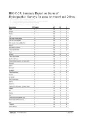
Report - IHO
Report - IHO
Report - IHO

You also want an ePaper? Increase the reach of your titles
YUMPU automatically turns print PDFs into web optimized ePapers that Google loves.
7<br />
Restructuring of a national hydrographic service (John Klippen, Jeppesen)<br />
The Hydrographic Institute of the Republic of Croatia (HHI) and the Norwegian<br />
Hydrographic Service (NHS) defined the CRONO HIP (CROatian-NOrwegian Hydrographic<br />
Information Project) joint project which aims at providing the HHI with new technologies and<br />
methods for data collection, data management and chart production.<br />
MINTEC – Maritime Infrastructure New Technology for production/management of ENC<br />
and paper Charts (John Klippen, Jeppesen)<br />
The MINTEC program will provide the Norwegian Hydrographic Service (NHS) with an<br />
interface to existing back-office system and all means for production and maintenance of<br />
ENC and paper charts. Production and maintenance are based on sources and revisions<br />
collected from the primary data base and other miscellaneous formats. The MINTEC system<br />
will also support data handling through OGC (Open GIS Consortium) services (Web Map<br />
Services, WMS, and Web Feature Services, WFS).<br />
General information on the project was given.<br />
SDI developments in Europe (Paul Canham, UK)<br />
The European directive INSPIRE (INfrastructure for SPatial Information in Europe) which<br />
aims at establishing an infrastructure for marine and geographic data was described. This will<br />
promote access to metadata, interoperability of spatial data sets, network services, data<br />
sharing, …<br />
The role of the <strong>IHO</strong> Marine Spatial Data Infrastructure Working Group (MSDIWG) was also<br />
highlighted<br />
The UK Marine Environmental Data and Information Network (MEDIN) was presented. The<br />
objective is to improve knowledge of, access to and dissemination of marine data across all<br />
sectors related to the marine community in United-Kingdom.<br />
Introduction to MSDI: SHOM practical experience, the INFRAGEOS project (Jean Laporte,<br />
SHOM and Maarten Peters, Caris)<br />
The benefits of marine spatial data infrastructures (MSDI) in hydrographic offices were<br />
highlighted. The example of INFRAGEOS-H project which aims at procuring an<br />
interoperable data base management system capable of providing better access to optimised<br />
georeferenced databases and improved information processing was given. The INFRAGEOS-<br />
H project is the first step in a broader process consisting of grouping together within a<br />
coherent system all SHOM databases.<br />
Jeppesen Marine: navigational and logistic solutions (Justin Homby, Jeppesen)<br />
A presentation of Jeppesen company, products and services was given.<br />
Distribution of hydrographic data & products (Paul Canham, UK)<br />
Admiralty products and the corresponding distribution network were presented. Based on the<br />
example of IC-ENC, RENC organization and benefits of membership were highlighted.<br />
These presentations gave raise to a question. Which benefits can Coastal States gain from<br />
these tools acknowledging that the principal difficulty for national hydrographic services is to<br />
access existing data from port authorities, industry...? Moreover, are these sophisticated<br />
infrastructures suitable for developing countries where maritime safety has a low priority<br />
compared to other needs and where it is difficult to persuade the appropriate government<br />
authority?<br />
7