TheImprovement ofTropical and Subtropical Rangelands
TheImprovement ofTropical and Subtropical Rangelands TheImprovement ofTropical and Subtropical Rangelands
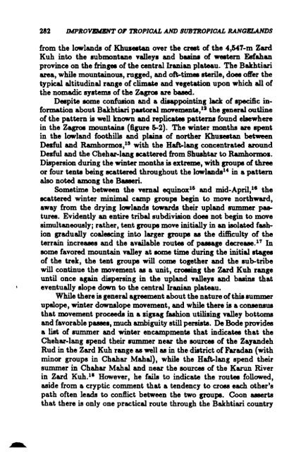
282 IMPROVDaNT0' TROPIOAL AND SUBTROPIOAL RANGELANDS from the lowlands of Khus.tan over the creet of the 4,547-m Zard Kuh into the submontane valleys and buina of western Esfahan province on the !rinses of the central Iranian plateau. The Bakhtiari area, while mountainous, ruSSed, and oft-times sterile, does oWer the typical altitudinal range of climate and vegetation upon which all of the nomadic systems of the Zagros are based. Despite some confusion and a diAppointing lack of specific information about Bakhtiari putorallDOYements,12 the general outline of the pattem is well known and replicates patterns found el8ewhere in the Zagros mountains (figure 5-2). The winter months are spent in the lowland foothills and plains of norther Khulfllltan between Desful and Ramhormoz,1S with the Haft-lang concentrated around Dezful and the Chehar-lang ecattered from Shushtar to Ramhormos. Dispersion during the winter months is extreme, with groups ofthree or four tents beingecattered throughout the lowlands 14 in a pattern also noted among the Bueeri. Sometime between the vemal equinox 16 and mid-April,us the ecattered winter minimal camp groups begin to move northward, away from the drying lowlands towards their upland summer ~ tures. Evidently an entire tribal subdivision does not begin to move simultaneously; rather, tent groups move initially in an isolated fashion gradually coalescing into larger groups as the difficulty of the terrain increuea and the available routes of pusage decrease. 1 T In some favored mountain valley at some time during the initial stages of the trek, the tent groups will come together and the sub-tribe will continue the movement as a unit, croIBing the Zard Kuh range until once again dispersing in the upland valleys and basins that eventually slope down to the central Iranian plateau. While there is general agreement about the natureofthis summer upslope, winter d0WD81ope movement, and while there is a COIUleIl8U8 that movement proceeds in a zigzag fuhion utilizing valley bottoms and favorable pUlleS, much ambiguity still persists. De Bode provides a list of summer and winter encampments that indicates that the Chehar-lang spend their summer near the sources of the Zayandeh Rud in the Zard Kuh range as well as in the district of Faradan (with minor groups in Chahar Mahal), while the Haft-lang spend their summer in Chahar Mahal and near the sources of the Karun River in Zard Kub. 11 However, he fails to indicate the routes followed, aside from a cryptic comment that a tendency to croes each other's path often leads to conflict between the two groups. Coon asserts that there is only one practical route through the Bakhtiari country
~ ~ K H a z'E 5 TiN 32 Direction of Move"'ent )\ POll (Gordonell' o Lond over 2000m. a 100 I ! '''' I~ ~ ~ ~ f: I ~ ~ ...1 FIGURE 5-2 BakMiari putoral movemenb. ~ CoO
- Page 241 and 242: THE BENI MGUILD OF MOROOOO 231 thei
- Page 243 and 244: THE BENI MGUILD OF MOROOOO 238 Alth
- Page 245 and 246: THE BEN! MGUILD OF MOROOOO 235 -tle
- Page 247 and 248: Case Study 3 The Kel Tamasheq SUSAN
- Page 249 and 250: TIn: KEL TAMASHEQ 239 TABLE 8-1 Ave
- Page 251 and 252: THE KEL TAMAS11EQ 20U TABLE S-4 Com
- Page 253 and 254: TIlE KEL TAMASHEQ TABLE 3-6 Proport
- Page 255 and 256: THE KEL TAMABHEQ 245 maintain healt
- Page 257 and 258: 25 0 25 IlO 75100 , ";) ~ 1:25kmL N
- Page 259 and 260: THE KEL TAMASHEQ the two somehow me
- Page 261 and 262: • Major well • Seuonal ftll •
- Page 263 and 264: THE KEL TAMASHEQ 253 FIGURE 3-3 T8n
- Page 265 and 266: THE KEL TAMASHEQ 255 N 1 I.. I ----
- Page 267 and 268: THE KEL TAMASHEQ 257 about 10 m to
- Page 269 and 270: TABLE 1-10 ComparUoD ofU_ of Variou
- Page 271 and 272: Case Study 4 Dromedary Pastoralism
- Page 273 and 274: DROMEDARY PASTORALISM IN AFRIOA AND
- Page 275 and 276: DROMEDARY PASTORAUSM IN AFRIOA AND
- Page 277 and 278: DROMEDARY PASTORALISM IN AFRIOA AND
- Page 279 and 280: DROMEDARY PASTORALISM IN AFRIOA AND
- Page 281 and 282: DROMEDARY PASTORALISM IN AFRIOA AND
- Page 283 and 284: DROMEDARY PASTORALISM IN AFRIOA AND
- Page 286 and 287: 276 IMPROVEMENT OF TROPIOAL AND SUB
- Page 288 and 289: 278 IMPROVEMENT OF TROPIOAL AND 8UB
- Page 290 and 291: 280 IMPROVEMENT OF TROPIOAL AND SUB
- Page 294 and 295: 284 IMPROVEMENT OF TROPICAL AND SUB
- Page 296 and 297: 286 IMPROVEMENT OF TROPICAL AND SUB
- Page 298 and 299: Case Study 6 The Marri Baluch ofPak
- Page 300 and 301: 290 IMPROVEMENT 0' TROPIOAL AND SUB
- Page 302 and 303: 292 IMPROVEMENT OF TROPIOAL AND SUB
- Page 304 and 305: 294 IMPROVEMENT OF TROPIOAL AND SUB
- Page 306 and 307: 296 IMPROVEMENT OF TROPIOAL AND SUB
- Page 308 and 309: Case Study 7 Changing Patterns ofRe
- Page 310 and 311: 800 IMPROVEMENT OF TROPIOAL AND SUB
- Page 312 and 313: 802 IMPROVEMENT OF TROPIOAL AND SUB
- Page 314 and 315: ~ IMPROVEMENT OF TROP/GAL AND SUBTR
- Page 316 and 317: 30& IMPROVBlD:NT OF TROPICAL AND SU
- Page 318 and 319: 308 IMPROVEMENT OF TROPIOAL AND SUB
- Page 320 and 321: 310 IMPROVI:ID:NT OF TROP/GAL AND B
- Page 322 and 323: Case Study 8 Kenya: Seeking Remedie
- Page 324 and 325: 314 IMPROVEMENT OF TROPICAL AND SUB
- Page 326 and 327: 316 IMPROVEMENT OF TROPIOAL AND SUB
- Page 328 and 329: 318 IMPROVEMENT OF TROPICAL AND SUB
- Page 330 and 331: 320 IMPROVEMENT OF TROPICAL AND SUB
- Page 332 and 333: 322 IMPROVEMENT OF TROPIOAL AND SUB
- Page 334 and 335: 324 IMPROVEMENT OF TROPIOAL AND SUB
- Page 336 and 337: 326 IMPROVEMENT OF TROPICAL AND SUB
- Page 338 and 339: 328 IMPROVEMENT OF TROPICAL AND SUB
- Page 340 and 341: 330 IMPROVEMENT OF TROPICAL AND SUB
282 IMPROVDaNT0' TROPIOAL AND SUBTROPIOAL RANGELANDS<br />
from the lowl<strong>and</strong>s of Khus.tan over the creet of the 4,547-m Zard<br />
Kuh into the submontane valleys <strong>and</strong> buina of western Esfahan<br />
province on the !rinses of the central Iranian plateau. The Bakhtiari<br />
area, while mountainous, ruSSed, <strong>and</strong> oft-times sterile, does oWer the<br />
typical altitudinal range of climate <strong>and</strong> vegetation upon which all of<br />
the nomadic systems of the Zagros are based.<br />
Despite some confusion <strong>and</strong> a diAppointing lack of specific information<br />
about Bakhtiari putorallDOYements,12 the general outline<br />
of the pattem is well known <strong>and</strong> replicates patterns found el8ewhere<br />
in the Zagros mountains (figure 5-2). The winter months are spent<br />
in the lowl<strong>and</strong> foothills <strong>and</strong> plains of norther Khulfllltan between<br />
Desful <strong>and</strong> Ramhormoz,1S with the Haft-lang concentrated around<br />
Dezful <strong>and</strong> the Chehar-lang ecattered from Shushtar to Ramhormos.<br />
Dispersion during the winter months is extreme, with groups ofthree<br />
or four tents beingecattered throughout the lowl<strong>and</strong>s 14 in a pattern<br />
also noted among the Bueeri.<br />
Sometime between the vemal equinox 16 <strong>and</strong> mid-April,us the<br />
ecattered winter minimal camp groups begin to move northward,<br />
away from the drying lowl<strong>and</strong>s towards their upl<strong>and</strong> summer ~<br />
tures. Evidently an entire tribal subdivision does not begin to move<br />
simultaneously; rather, tent groups move initially in an isolated fashion<br />
gradually coalescing into larger groups as the difficulty of the<br />
terrain increuea <strong>and</strong> the available routes of pusage decrease. 1 T In<br />
some favored mountain valley at some time during the initial stages<br />
of the trek, the tent groups will come together <strong>and</strong> the sub-tribe<br />
will continue the movement as a unit, croIBing the Zard Kuh range<br />
until once again dispersing in the upl<strong>and</strong> valleys <strong>and</strong> basins that<br />
eventually slope down to the central Iranian plateau.<br />
While there is general agreement about the natureofthis summer<br />
upslope, winter d0WD81ope movement, <strong>and</strong> while there is a COIUleIl8U8<br />
that movement proceeds in a zigzag fuhion utilizing valley bottoms<br />
<strong>and</strong> favorable pUlleS, much ambiguity still persists. De Bode provides<br />
a list of summer <strong>and</strong> winter encampments that indicates that the<br />
Chehar-lang spend their summer near the sources of the Zay<strong>and</strong>eh<br />
Rud in the Zard Kuh range as well as in the district of Faradan (with<br />
minor groups in Chahar Mahal), while the Haft-lang spend their<br />
summer in Chahar Mahal <strong>and</strong> near the sources of the Karun River<br />
in Zard Kub. 11 However, he fails to indicate the routes followed,<br />
aside from a cryptic comment that a tendency to croes each other's<br />
path often leads to conflict between the two groups. Coon asserts<br />
that there is only one practical route through the Bakhtiari country


