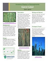
DCNR_20027626 - Pennsylvania Department of Conservation and ...
DCNR_20027626 - Pennsylvania Department of Conservation and ...
DCNR_20027626 - Pennsylvania Department of Conservation and ...

Create successful ePaper yourself
Turn your PDF publications into a flip-book with our unique Google optimized e-Paper software.
···cOMMONWEALTH OF PENNSYLVANIA·<br />
. :Richard L. Thornburgh, Governor.c __ -'_<br />
/,· ,,· .<br />
;';<br />
I, .~,_,'•' ,. ;:- • ," ,'-' .:. ' ' • ' •
FROM TH E DESK<br />
OF THE<br />
STATE GEOLOGIST . ..<br />
CRISIS ACTIONS OR PREVENTIVE ACTIONS<br />
-A CHOICE<br />
Some twenty years ago we entered an era when planning became a respectable<br />
word in most fields, including science, government, academic<br />
<strong>and</strong> social work. There was great hope (<strong>and</strong> expectation) that America's<br />
propensity for " decision by crisis" would be replaced by the more efficient<br />
<strong>and</strong> effective process <strong>of</strong> progress by orderly planning <strong>and</strong> implementation.<br />
In large measure the great hope has not materialized. For w hatever reason,<br />
the c harisma <strong>and</strong> respect for orderly planning appears to have faded; it may<br />
be due in part to the fact that so <strong>of</strong>ten planning was not followed by implementation,<br />
leaving the image <strong>of</strong> planning as an abstract, non-utilitarian<br />
process.<br />
The August 7th New York Times editorial headline reads, " The Mineral<br />
Problem Is Not A Crisis." It goes on to Jist a number <strong>of</strong> facts (actually called<br />
facts by the paper) including " America imports more than half its supply <strong>of</strong><br />
some 20 strategically important minerals" <strong>and</strong> " Several <strong>of</strong> these come<br />
from unfriendly or politically vulnerable countries, including the Soviet<br />
Union, South Africa, <strong>and</strong> Turkey." Then, after commenting on these facts<br />
<strong>and</strong> the U.S. Government's plans for remedial actions, the paper comes to a<br />
fascinating conclusion: " It's prudent to worry about dependence on<br />
mineral imports. It is foolish to let these worries produce a blind ru sh for<br />
import independence."<br />
I find their conclusions amazing! By the newspaper's logic, to worry is<br />
O. K., to do something about it is " foolish." And sin ce when has federal action<br />
deserved the characterizat ion <strong>of</strong> "blind rush " ? Many <strong>of</strong> us have long<br />
been convinced that the U.S. is vulnerable to foreign sources <strong>of</strong> raw materials<br />
essential to our economy, as well as our security. The 1973 oil embargo<br />
was a Jesson by crisis. Do we have to wait for another crisis in order<br />
to act?<br />
The c hallenge <strong>of</strong> implementing action by oth er then crisis is not limited<br />
to federal or national issues. State <strong>and</strong> local programs face that chall enge.<br />
The recent drought, somewhat alleviated by moderate rainfall, leaves one<br />
wonder if adequate plans <strong>and</strong> procedures will be implemented before the<br />
next drought period comes around- or will we do essentially nothing, as<br />
was the case after the drought <strong>of</strong> the mid-sixties? And those <strong>of</strong> us in <strong>Pennsylvania</strong><br />
who were directly affected by the Ag nes <strong>and</strong> Eloise fl oods <strong>of</strong> 1972<br />
<strong>and</strong> 1975 are still looking about for tangible evidence that something w ill<br />
be done to prevent such future disasters.<br />
Th ere are actions that can be taken to forestall, or at least mitigate suc h<br />
problems as outlined above. But when such a prestigious newspaper as<br />
the New York Times says go slow, because the "-Problem Is Not A Crisis"<br />
it is a sign that reaction to crisis still previals as the dominant decision<br />
making process.<br />
We can do better. Mankind is supposedly blessed with the ability to<br />
reason <strong>and</strong> to Jearn from experiences <strong>of</strong> the past. It is time to convert from<br />
c ri sis decisions to the m uch less costly, more effective process <strong>of</strong> preventive<br />
actions. ~c . ~<br />
I
GEOLOGICAL RESEARCH<br />
JN PENNSYLVANIA<br />
1981<br />
INTRODIJCTION<br />
This publication is the twenty-fourth annual report on Geological<br />
Research <strong>and</strong> Publications in <strong>Pennsylvania</strong>. This is an<br />
attempt to list all current geologic research in Pennsylvan ia<br />
<strong>and</strong> includes persons <strong>and</strong> projects other than those <strong>of</strong> the<br />
<strong>Pennsylvania</strong> Geological Survey. Because <strong>of</strong> the large number<br />
<strong>of</strong> projects reported to us, we exercise editorial license to<br />
reduce the description <strong>of</strong> t he research projects to fit our<br />
available space.<br />
We have also attempted to determine an anticipated<br />
completion date (ACD) for each project. The anticipated completion<br />
date is the estimate <strong>of</strong> the date when the author will<br />
complete his report; additional time should be anticipated<br />
until the report is published. If you wish more information on<br />
a project described herein, please write directly to the author;<br />
most <strong>of</strong> these projects will not be published by the <strong>Pennsylvania</strong><br />
Geological Survey inasmuch as most are not Survey<br />
staff projects.<br />
The listings are grouped into major categories <strong>of</strong> research<br />
to facilitate your search for information on a particular subject.<br />
Reports published are listed alphabetically by author.<br />
As with all compilations, there may be omissions; this is<br />
unintentional. Additional copies <strong>of</strong> this report may be obtained<br />
by writing to the Bureau <strong>of</strong> Topgraphic <strong>and</strong> Geologic<br />
Survey, <strong>Department</strong> <strong>of</strong> Environmental Resources, P.O. Box<br />
2357, Harrisburg, <strong>Pennsylvania</strong> 17120.<br />
AR£A1 G£010GY<br />
ROBIN ABEL, The Pa. State Univ., <strong>and</strong> T. M. BERG <strong>and</strong> W. D.<br />
SEVON, Pa. Geol. Survey. Li thologic Map <strong>of</strong> <strong>Pennsylvania</strong>. This map<br />
wi ll show (at a scale <strong>of</strong> 1 :500,000) about 25 rock units across Pen n<br />
sylvania <strong>and</strong> is being derived from the new state geologic map.<br />
ACD: Early 1982.<br />
2
J.D. INNERS, Pa. Geol. Survey. Geology <strong>and</strong> Mineral Resources <strong>of</strong><br />
the Allenwood <strong>and</strong> Milton Quads., Lycoming, Union, Northumberl<strong>and</strong>,<br />
<strong>and</strong> Montour Cos., Pa. ACD: 1983.<br />
P. T. LYTTLE, Project Chief, U.S. Geol. Survey. Newark 2-Degree<br />
Quad. Reconnaissance geologic mapping <strong>of</strong> the southern part <strong>of</strong><br />
the Triassic-Jurassic Newark Basin <strong>and</strong> adjacent Paleozoic <strong>and</strong> Proterozoic<br />
rocks <strong>of</strong> the <strong>Pennsylvania</strong> P~edmont will take place during<br />
FY 1981 . Detailed reconnaissance <strong>of</strong> the major faults in this terrane<br />
will be carried out with particular emphasis on the Huntingdon Valley<br />
fault, the Cream Valley fault, <strong>and</strong> the Rosemont fault. ACD: Continuing.<br />
HOWARD POHN <strong>and</strong> A. R. TAYLOR, U.S. Geol. Survey, G. H.<br />
CROWL, Ohio Wesleyan Univ., G. W. COLTON , U.S. Geol. Survey, retired,<br />
<strong>and</strong> T. L. PURDY, U.S. Geol. Survey. Geology <strong>and</strong> Mineral Resources<br />
<strong>of</strong> the Jersey Shore Quad., Clinton <strong>and</strong> Lycoming Cos.<br />
Field mapping <strong>of</strong> the bedrock geology is complete, <strong>and</strong> <strong>of</strong>fice compilation<br />
<strong>of</strong> final copy is well underway. Unusually complex faulting,<br />
folding, <strong>and</strong> disturbed zo nes occur in this area along the Allegheny<br />
Front. The field mapping <strong>of</strong> Pleistocene <strong>and</strong> other surficial deposits<br />
is underway (Crowl). ACD: Dec. 1981.<br />
H. W. SCHASSE, Wash. Dept. <strong>of</strong> Natural Resources, <strong>and</strong> D. B.<br />
MacLACHLAN, Pa. Geol. Survey. Geology an d Mineral Resources <strong>of</strong><br />
the Conyngham Quad., Luzerne <strong>and</strong> Schuylkill Cos. Geologic mapping<br />
completed by Schasse; coal reserves currently under investigation<br />
by Maclachlan.<br />
W. D. SEVON <strong>and</strong> T. M. BERG, Pa. Geol. Survey, L. D. SCHULTZ, Gilbert<br />
Assoc., <strong>and</strong> G. H. CROWL, Ohio Wesleyan Univ. Geology <strong>and</strong><br />
Mineral Resources <strong>of</strong> Pike Co., Pa. ACD: Oct. 1,1981.<br />
A. N. WARD, JR., Slippery Rock St. Coli. Bedrock Mapping <strong>of</strong> Titusville<br />
N. <strong>and</strong> S. ?1/2' Quads. ACD: 1985.<br />
J . H. WAY, Pa. Geol. Survey. Geology <strong>and</strong> Mineral Resources <strong>of</strong> the<br />
Washington <strong>and</strong> Millville Quads., Montour, Columbia, <strong>and</strong> Northumberl<strong>and</strong><br />
Cos. , Pa. Geologic mapping <strong>of</strong> bedrock <strong>and</strong> surficial deposits,<br />
defining <strong>and</strong> sampling materials with possible economic potential<br />
, <strong>and</strong> describing environmental <strong>and</strong> engineering characteristics<br />
<strong>of</strong> all geologic units in the area. ACD: 1982.<br />
ECONOMIC G£010GY<br />
K. D. ABEL, Pa. Geol. Survey. Oil Fields <strong>of</strong> Southwestern Pa. Thereport<br />
w ill be a summary <strong>of</strong> the history <strong>and</strong> geology <strong>of</strong> the oil fields <strong>of</strong><br />
Allegheny, Beaver, Greene, <strong>and</strong> Washington Counties. ACD: Sept.<br />
1981 .<br />
3
S. W. BERKHEISER, JR., Pa. Geol. Survey. Preliminary Reconnaissance<br />
<strong>of</strong> Potential Carbonate "Whiting" in South-Central <strong>and</strong> Southeastern<br />
Pa. Preliminary test results are interpreted to suggest that<br />
the most favorable source rocks may underlie parts <strong>of</strong> Chester <strong>and</strong><br />
York Counties. Test results include dry brightness <strong>and</strong> chemical<br />
analysis for identified sources. ACD: Aug. 1981 .<br />
R. P. BRIGGS, Geomega, Inc. Reconnaissance Reexamination <strong>of</strong><br />
Mineral Potential <strong>of</strong> the State Line District, Md. <strong>and</strong> Pa. [Chester <strong>and</strong><br />
Lancaster Cos., Pa., <strong>and</strong> Cecil Co., Md.]. ACD: Fall 1981 .<br />
S. H. CLARK, Project Chief, U.S. Geol. Survey. Lead-Zinc-Barite<br />
Fluorite Resources <strong>of</strong> the East-Central U.S. Initial data compilation<br />
from a literature review for the States <strong>of</strong> New York, <strong>Pennsylvania</strong>,<br />
West Virginia, Kentucky, Virginia, Tennessee, Alabama, Illinois,<br />
Michigan, Wisconsin, Georgia, Ohio, <strong>and</strong> Indiana will be completed<br />
in FY 1981 . This will include contacting people familiar with deposits<br />
<strong>and</strong> occurrences in each state in order to supplement data in<br />
the literature. Preliminary drafting <strong>of</strong> metallogenic maps for these<br />
states will also get underway.<br />
W. E. EDMUNDS, Consulting Coal Geologist, <strong>and</strong> J. R. EGGLES<br />
TON, Skelly & Loy. Anthracite Coal Basins <strong>of</strong> Pa. Summary <strong>of</strong> the<br />
economic coal geology <strong>of</strong> the anthracite fields. ACD: June 1981.<br />
W. E. EDMUNDS, Consulting Coal Geologist, <strong>and</strong> J. R. EG<br />
GLESTON, Skelly & Loy. Statistical Control <strong>of</strong> Anthracite Exploratory<br />
Drilling. The number <strong>of</strong> exploratory drill holes necessary to estimate<br />
the coal reserves <strong>of</strong> a property within predetermined limits<br />
<strong>and</strong> with a predetermined level <strong>of</strong> confidence can be determined by<br />
application <strong>of</strong> statistical probability formulas. ACD: 1982.<br />
A. D. GLOVER, C. H. DODGE, J. R. SHAULIS, <strong>and</strong> V. W. SKEMA, Pa.<br />
Geol. Survey. Coal Resources <strong>of</strong> Greene, Washington, Allegheny,<br />
Fayette, Westmorel<strong>and</strong>, Beaver, Butler, Cambria, Indiana, <strong>and</strong> Somerset<br />
Cos. Data for coal-bearing strata in Greene, Washington, <strong>and</strong><br />
Allegheny Counties have been entered into the National Coal Resources<br />
Data System (NCRDS) computer. Information for Fayette,<br />
Westmorel<strong>and</strong>, Beaver, Butler, Cambria, Indiana, <strong>and</strong> Somerset<br />
Counties is currently being assembled <strong>and</strong> prepared for entry into<br />
the system. This will result in computer-generated geologic <strong>and</strong> resource<br />
maps for western Pa.<br />
J. A. HARPER <strong>and</strong> C. D. LAUGHREY, Pa. Geol. Survey, <strong>and</strong> W. S.<br />
LYTLE. Oil <strong>and</strong> Gas Fields Map <strong>of</strong> Pa. The map will show the oil <strong>and</strong><br />
gas fields <strong>and</strong> will identify the producing formations in each.<br />
4
A. G. HARRIS, Project Chief, U.S. Geol. Survey. Conodont Maturation<br />
Studies. Major emphasis during FY 1981 will be to use conodont<br />
color alteration indexing to assess the oil, condensate, <strong>and</strong><br />
natural gas potential <strong>of</strong> Middle <strong>and</strong> Upper Devonian black shales in<br />
the Appalachian basin, <strong>and</strong> to provide conodont-based age determinations<br />
for correlation <strong>of</strong> the black shale succession in outcrops<br />
<strong>and</strong> boreholes. Age determinations <strong>and</strong> thermal analysis <strong>of</strong> black<br />
shale core samples obtained from Erie County, Pa., <strong>and</strong> Montgomery<br />
County, Ky., will be completed.<br />
K. B. KETNER, Project Chief, U.S. Geol. Survey. Silica Resources <strong>of</strong><br />
the U.S. Field work for FY 1981 has already been done in Tennessee,<br />
Virginia, West Virginia, Maryl<strong>and</strong>, New Jersey, <strong>Pennsylvania</strong>, <strong>and</strong><br />
New York. This consisted <strong>of</strong> reconnaissance <strong>of</strong> high-purity quartz<br />
arenites in the Tuscarora <strong>and</strong> Oriskany Fms. Samples were taken for<br />
mineralogical <strong>and</strong> chemical analyses. Compiling a map <strong>of</strong> these<br />
units will contribute to an eventual assessment <strong>of</strong> the national highgrade<br />
silica resource base. ACD: Continuing.<br />
ANTON KLAVER, Mobil Oil Co. Evaluation <strong>of</strong> the Economic Potential<br />
<strong>of</strong> Devonian Black Shales. ACD: Ongoing.<br />
C. D. LAUGHREY, Pa. Geol. Survey. Geology <strong>of</strong> the Kane S<strong>and</strong>,<br />
Cush Cushion Field, Indiana Co., Pa. Development drilling in eastern<br />
Indiana County has defined a limited but substantially productive<br />
Upper Devonian s<strong>and</strong> trend. The reservoir is described <strong>and</strong> explained.<br />
The report includes two cross sections <strong>and</strong> three maps<br />
which illustrate the trend. ACD: April1981 .<br />
G. W. LENEY, U.S. Dept. <strong>of</strong> Energy, <strong>and</strong> BENDIX FIELD ENGINEER<br />
ING CORPORATION. National Uranium Resource Evaluation Program<br />
(NURE) [entire U.S.]. Work carried out in <strong>Pennsylvania</strong> includes<br />
portions <strong>of</strong> reconnaissance airborne radiometric surveys, hydrogeoc<br />
hemical <strong>and</strong> stream sediment reconnaissance surveys, <strong>and</strong> supplementary<br />
analytical work, geologic evaluations for favorability for<br />
the occurrence <strong>of</strong> uranium deposits, <strong>and</strong> research projects.<br />
ACD: 1983.<br />
·~<br />
F. G. LESURE, U.S. Geol. Survey. Cornplanter Roadless Area, Pa.<br />
Mineral resource assessment <strong>of</strong> area. ACD: Dec. 1981 .<br />
J . S. LEVENTHAL, Project Chief, U.S. Geol. Survey. Uranium <strong>and</strong><br />
Trace Elements in Devonian Black Shale. This project has been extended<br />
for a portion <strong>of</strong> FY 1981 to complete work on organic matter,<br />
trace elements, <strong>and</strong> uranium in Devonian black shales from the<br />
Appalachian Basin. This will include determination <strong>of</strong> geochemical<br />
5
controls, uranium resources, <strong>and</strong> sulfur-carbonate isotope relationships.<br />
Relationship <strong>of</strong> geochemistry to depositional environment,<br />
mineralogy, <strong>and</strong> stratigraphy will also continue. ACD: Sept. 1981 .<br />
R. W. LUCE, Project Chief, U.S. Geol. Survey. Metallogeny <strong>of</strong> Acid<br />
Altered Volcanogenic Mineral Deposits. Maps showing mineral deposits<br />
in the Appalachian Orogen that contain significant amounts<br />
<strong>of</strong> gold, pyrophyllite, kyanite, topaz, tourmaline <strong>and</strong>(or) hydrothermal<br />
clays will be compiled <strong>and</strong>, where possible, categorized as<br />
to size, type, <strong>and</strong> mineral assemblage during FY 1981. The location<br />
<strong>of</strong> the deposits will be plotted on 1:1 ,000,000 lith<strong>of</strong>acies, lineament,<br />
aeromagnetic, gravity, <strong>and</strong> radiometric maps. Genetic interpretation<br />
will be made <strong>of</strong> the resulting relationships. ACD: Continuing.<br />
J. B. ROEN , Project Chief, U.S. Geol. Survey. Stratigraphy <strong>of</strong> Devonian<br />
Black Shale in Appalachian Basin. Reports on the ash fall<br />
nomenclature in the Appalachian Basin, the Tully Limestone, the<br />
areal distribution <strong>of</strong> the New Albany, Chattanooga, <strong>and</strong> Ohio Shales<br />
in Kentucky, <strong>and</strong> the final report documenting the results <strong>of</strong> this<br />
project will be prepared for publication. ACD: Sept. 1981 .<br />
J. W. SCHMOKER, Project Chief, U.S. Geol. Survey. Borehole Gravity<br />
Survey, Devonian Black Shale, Appalachian Basin. Final report<br />
writing on the organic matter content <strong>of</strong> the Devonian Shale <strong>and</strong> a<br />
summary report, including contributing information to the resource<br />
appraisal being developed for the Appalachian Basin, will take<br />
place in the first half <strong>of</strong> FY 1981 . ACD: Sept. 1981 .<br />
S. P. SCHWEINFURTH, Project Chief, U.S. Geol. Survey. <strong>Pennsylvania</strong><br />
RARE II Areas. RARE II areas in <strong>Pennsylvania</strong> will be mapped<br />
<strong>and</strong> geochemically sampled during FY 1981 in order to determine<br />
the mineral resource potential <strong>of</strong> each area. Reports <strong>and</strong> maps<br />
documenting the results <strong>of</strong> these investigations will be prepared for<br />
publication. ACD: Sept. 1981 .<br />
A. T. SMITH <strong>and</strong> A. W. ROSE, The Pa. State Univ. Regional Sedimentologic<br />
<strong>and</strong> Geochemical Controls for Red-Bed Copper <strong>and</strong><br />
Uranium in the Devonian Catskill Fm. <strong>of</strong> Pa. The characteristics <strong>of</strong><br />
the Catskill sedimentary basin <strong>and</strong> <strong>of</strong> diagenetic processes are<br />
being studied to evaluate factors involved in mineral deposition. Research<br />
includes isotopic studies <strong>of</strong> sulfur, carbon, oxygen, <strong>and</strong><br />
lead, fluid inclusions formed during diagenesis, <strong>and</strong> computer<br />
modeling <strong>of</strong> pore-fluid movement during compaction. ACD: 1982.<br />
R. C. SMITH, II, <strong>and</strong> J. H. BARNES, Pa. Geol. Survey. Geologic <strong>and</strong><br />
Mineralogic Interpretation <strong>of</strong> Gamma-Ray Reconnaissance Data for<br />
the Reading Prong, Eastern Pa. [portions <strong>of</strong> Berks, Bucks, Lehigh,<br />
6
<strong>and</strong> Northampton Cos.]. Lithologic samples have been taken <strong>of</strong><br />
sites where gamma-ray anomalies have been detected with a carborne<br />
survey. Petrographic, mineralogic, <strong>and</strong> geochemical studies<br />
are in progress for those anomalies related to uranium mineralization.<br />
ACD: 1982.<br />
R. C. SMITH, II, Pa. Geol. Survey, <strong>and</strong> D. T. HOFF, Wm. Penn Memorial<br />
Museum. Copper-Uranium Occurrences in the Catskill Fm., Picture<br />
Rocks <strong>and</strong> Sonestown Quads., Pa. [Lycoming <strong>and</strong> Sullivan<br />
Cos.]. Geologic <strong>and</strong> mineralogic studies <strong>of</strong> 50 small Cu-U bearing<br />
lenses have been completed <strong>and</strong> a report is being prepared. Quantitative<br />
analyses for U, Cu, As, <strong>and</strong> Pb are included for 60 channel<br />
samples as well as descriptions <strong>of</strong> several rare minerals.<br />
ACD: 1981 .<br />
R. B. WELLS, Consulting Geologist. Natural Gas Potential <strong>of</strong> the<br />
Ridgeley S<strong>and</strong>stone in North-Central Pa. Petroleum reservoir conditions<br />
similar to the Salladasburg Gas Field are thought to exist in<br />
the Lower Devonian s<strong>and</strong>stones elsewhere in Lycoming <strong>and</strong> adjacent<br />
counties. The objective <strong>of</strong> this study is to identify those areas<br />
which have the greatest potential for economic natural gas production,<br />
utilizing both surface <strong>and</strong> subsurface geologic techniques.<br />
ACD: 1983.<br />
£NVIRONM£NT AL<br />
G£010GY<br />
R. L. DAVIS, PENNY TAYLOR, MICHAEL GARDNER, <strong>and</strong> DEBORAH<br />
HENTON, Univ. <strong>of</strong> Pitt. at Bradford. Water Quality in the Bradford<br />
Water Supply System. There have been significant chemical (iron),<br />
physical (turbidity), <strong>and</strong> bacteriological (Giardia) problems in the<br />
Bradford water supply system. We are trying to identify the sources<br />
<strong>of</strong> these problems <strong>and</strong> to recommend management techniques to<br />
deal with them. ACD: Apr. 1982.<br />
W. E. DAVIES, Project Chief, U.S. Geol. Survey. Safe Mine Waste<br />
Disposal. Investigation <strong>of</strong> clay minerals <strong>and</strong> the role <strong>of</strong> dispersive<br />
clays in l<strong>and</strong>slides will continue, along with investigation <strong>of</strong> void<br />
sizes critical in debris avalanches <strong>and</strong> their significance with regard<br />
to different amounts <strong>of</strong> precipitation. Detailed studies <strong>of</strong> 71/2-minute<br />
quadrangles within the Clarksburg, Bluefield, Pittsburgh, Canton,<br />
Charleston, Huntington, <strong>and</strong> Jenkins 2-degree quadrangles will<br />
be underway in FY 1981. These investigations include mapping<br />
" typical" l<strong>and</strong>slides, movement measurement, <strong>and</strong> pore pressure<br />
<strong>and</strong> stratigraphic studies <strong>of</strong> selected l<strong>and</strong>slides. ACD: Continuing.<br />
7
N. K. FLINT, RICHARD YEAGER, <strong>and</strong> JAMES KRUSHIN , Univ. <strong>of</strong><br />
Pitt. Project 1. Slope Stability <strong>and</strong> L<strong>and</strong>slide Hazards in the Little<br />
Sewickley Creek Watershed, Allegheny Co. Project 2. Slope Stability<br />
<strong>and</strong> L<strong>and</strong>slide Hazards in Indiana <strong>and</strong> Harmar Twps., Allegheny<br />
Co. These projects involve field mapping at a scale <strong>of</strong> 1 inch to 200<br />
feet. L<strong>and</strong>slide-risk maps are color-coded for easy interpretation by<br />
municipal <strong>of</strong>ficials <strong>and</strong> other nongeologists. ACD: Project 1, Aug.<br />
1981; Project 2, Dec. 1981.<br />
MARK GERMINE <strong>and</strong> J. H. PUFFER, Rutgers Univ. Asbestos Distribution<br />
in the Precambrian Marble <strong>of</strong> Easton <strong>and</strong> Forks Twps., Pa.<br />
Asbestos varieties present include tremolite, actionolite, <strong>and</strong><br />
chrysotile (a meerschaum-like variety). Potential environmental<br />
problems include contamination <strong>of</strong> an impounded water supply,<br />
excavations <strong>of</strong> bedrock <strong>and</strong> lower soil horizons, <strong>and</strong> neighborhood<br />
contact with quarry residuals. ACD: May 1981 .<br />
J. S. POMEROY, U.S. Geol. Survey. Slope Stability, Appalachians.<br />
Plans for 1981 include study in Oak Forest quad., Greene Co.<br />
G£N£RA1 G£010GY<br />
W. M. JORDAN <strong>and</strong> R. M. BENSON, Millersville St. Coli. Relationships<br />
between Geology <strong>and</strong> Industry in 19th Century Pa. [Anthracite<br />
region]. ACD: Continuing.<br />
WILLIAM KREIGER, Lock Haven St. Coli. Petrology <strong>of</strong> Bunker Hills<br />
Igneous Rocks [Bunker Hills, Lebanon Co., Pa., about 4 miles north<br />
<strong>of</strong> the city <strong>of</strong> Lebanon in Swatara Twp.] Preliminary reconnaissance<br />
<strong>of</strong> the Bunker Hills area <strong>and</strong> a literature search has been completed<br />
to date. Plans are for a petrographic study (optical <strong>and</strong> chemical<br />
analysis) <strong>of</strong> intrusive <strong>and</strong> extrusive igneous rocks in this area.<br />
ACD: 1984.<br />
J . P. WILSHUSEN, Pa. Geol. Survey. Geology <strong>of</strong> the Appalachian<br />
Trail in Pa. [SE Pa.]. A description <strong>of</strong> geologic characteristics <strong>of</strong><br />
each physiographic province with detailed, illustrated geologic accounts<br />
at points <strong>of</strong> interest along the route. Sketch maps with geologic<br />
cross sections <strong>and</strong> descriptions are keyed to a geologic map<br />
<strong>of</strong>thetraii.ACD: July31, 1981.<br />
G£0CH£MISTRY<br />
J. T. McNALLY <strong>and</strong> A. W. ROSE, The Pa. State Univ. Geochemistry<br />
<strong>of</strong> Carbonate Ground Waters as a Guide to Lead-Zinc Deposits in<br />
8
Central <strong>and</strong> Eastern Pa. About 160 well waters from Lancaster,<br />
Franklin, <strong>and</strong> Blair Counties have been analyzed for Fe, Ca, Na, K,<br />
Mg, Mn, Sr, Ba, Cu, Pb, Zn, HCOJ, SO., N03, Cl, F, pH, conductivity,<br />
<strong>and</strong> dissolved oxyg en. Contents <strong>of</strong> so., Sa, Pb, <strong>and</strong> Zn are<br />
anomalous near at least some <strong>of</strong> the three known Pb-Zn occurrences<br />
that were studied. Saturation indices <strong>and</strong> interrelations <strong>of</strong><br />
elements appear to improve the contrast <strong>of</strong> anomalies. ACD: 1981 .<br />
H. A. TOURTELOT, Project Chief, U.S. Geol. Survey. Environmental<br />
Geochemistry, Southeastern U.S. Urban geochemistry studies will<br />
c ontinue in the Pittsburgh <strong>and</strong> Washington, Pa. areas. Efforts will<br />
be made to characterize the dioctahedral chlorite in flint clays collected<br />
in Missouri <strong>and</strong> <strong>Pennsylvania</strong>. ACD: Continuing.<br />
J. W. TROESTER <strong>and</strong> W. B. WHITE, The Pa. State Univ. The<br />
Seasonal Variation <strong>of</strong> Carbon Dioxide in the Atmosphere <strong>of</strong> Tytoona<br />
Cave, Blair Co., Pa. The carbon dioxide content <strong>of</strong> the cave atmosphere<br />
is measured every two weeks by a Draeger multi-gas detector<br />
to determine the seasonal variation. Work began in spring, 1981 .<br />
Concentrations several times atmospheric have been measured.<br />
ACD: Summer 1982.<br />
GEOMORPHOLOGY<br />
D. D. BRAUN, Bloomsburg St. Coli., <strong>and</strong> J.D. INNERS, Pa. Geol. Survey,<br />
Seismic Investigations <strong>of</strong> the Orangeville " Umlaufberg" <strong>and</strong><br />
Tenmile Run Valley, Columbia Co., Pa. ACD: 1983.<br />
W. E. DAVIES, U.S. Geol. Survey. River Terrace <strong>and</strong> Colluvial Deposits<br />
<strong>of</strong> the Potomac Basin. Continuation <strong>of</strong> mapping <strong>of</strong> terraces in<br />
the headwaters area <strong>of</strong> the Potomac, mainly along Licking Creek,<br />
Tonoloway Creek, <strong>and</strong> Sideling Hill Creek. ACD: 1983. ·<br />
JACK DONAHUE <strong>and</strong> D. E. BEYNON, Univ. <strong>of</strong> Pitt. Geoarchaeology<br />
<strong>of</strong> Meadowcr<strong>of</strong>t Rockshelter [Washington Co.]. Development <strong>of</strong><br />
Meadowcr<strong>of</strong>t Rockshelter in terms <strong>of</strong> shelter formation <strong>and</strong> then<br />
generation <strong>of</strong> the colluvial sediment cone beneath the shelter.<br />
NOEL POTTER, JR., Dickinson Coli. Distribution <strong>and</strong> Origin <strong>of</strong><br />
Gravels <strong>and</strong> Colluvium in Cumberl<strong>and</strong> <strong>and</strong> Franklin Cos. ACD: Continuing.<br />
ANNETTE RUSSO, Lafayette Coli. Fabric Analysis <strong>of</strong> Boulders in<br />
the Blue Rocks Block Stream [Lenhartsville, Pa.]. ACD: June 1981 .<br />
W. B. WHITE, The Pa. State Univ. Caves <strong>of</strong> Pa. Description <strong>and</strong> maps<br />
are being compiled for all known caves in <strong>Pennsylvania</strong>. Volunteer<br />
9
cavers are field checking <strong>and</strong> resurveying caves as necessary. Data<br />
for Mifflin County were completed in 1980. ACD: Fall1981.<br />
W. B. WHITE <strong>and</strong> E. L. WHITE, The Pa. State Univ. Geomorphology<br />
<strong>of</strong> the Appalachian Karst [N.Y. to Ala.]. Quantitative analysis <strong>of</strong> l<strong>and</strong>form<br />
morphology <strong>and</strong> underground drainage systems for selected<br />
karst regions throughout the Appalachians. Current work is a detailed<br />
description <strong>of</strong> the karst <strong>of</strong> the Valley <strong>and</strong> Ridge province <strong>of</strong><br />
Pa. ACD: Continuing.<br />
GEOPHYSICS<br />
V. E. ALEO, City <strong>of</strong> Wilkes-Barre. Seismological History <strong>of</strong> Pa. A<br />
compilation <strong>of</strong> historical seismic activities throughout the state <strong>and</strong><br />
their possible underlying causes. ACD: 1983.<br />
W. H. DIMENT, Project Chief, U.S. Geol. Survey. Seismotectonics <strong>of</strong><br />
Northeastern U.S. A rational scheme for seismic zonation <strong>of</strong> the<br />
northeastern U.S., through study <strong>of</strong> deep geologic conditions are revealed<br />
by analysis <strong>of</strong> gravity, magnetic, heat flow, <strong>and</strong> seismic <strong>and</strong><br />
drilling data, will continue to be developed during FY 1981.<br />
ACD: Continuing.<br />
V. A. SCHMIDT, JACK DONAHUE, <strong>and</strong> H. R. ROLLINS, Univ. <strong>of</strong> Pitt.<br />
Paleomagnetism <strong>of</strong> Carboniferous Sediments in the Appalachian<br />
Basin [W. PA., E. Ohio, W. Va.]. To date good paleomagnetic pole<br />
positions have been obtained for the Brush Creek, Buffalo, Vanport,<br />
Loyalhanna, Pottsville, Wymps Gap, <strong>and</strong> Greenbrier Fms. In addition,<br />
polarities have been determined for many others. All but the<br />
Wymps Gap <strong>and</strong> Greenbrier display reversed polarities. ACD: 1983.<br />
GLACIAL GEOLOGY<br />
E. B. EVENSON <strong>and</strong> JAMES COTTER, Lehigh Univ., L.A. SIRKIN,<br />
Adelphi Univ., <strong>and</strong> W. D. SEVON, Pa. Geol. Survey. Wisconsinan Deglaciation<br />
Chronology <strong>of</strong> Northeastern Pa. <strong>and</strong> Northwestern N.J. In<br />
an attempt to establish a radiocarbon controlled deglaciation<br />
chronology for northeastern Pa. <strong>and</strong> northwestern N.J. 28 lakes <strong>and</strong><br />
bogs have been cored. Those with basal late-glacial pollen assemblages<br />
have been sampled for radiocarbon analysis. No dates are<br />
currently available. ACD: Jan. 1982.<br />
JACK RIDGE <strong>and</strong> E. B. EVENSON, Lehigh Univ., <strong>and</strong> CARL KOTEFF,<br />
U.S. Geol. Survey. [No title given.] Detailed surficial mapping was<br />
10
completed using the morpho-sequence concept. Combined map,<br />
provenance <strong>and</strong> soil analyses were used to reconstruct Wisconsinan<br />
maximum positions, geometry <strong>of</strong> deglaciation, <strong>and</strong> changing<br />
ice flow patterns <strong>and</strong> to provide base map information for stratigraphic<br />
<strong>and</strong> palynologic studies. ACD: Winter 1981-1982.<br />
HYDROLOGY<br />
A. E. BECHER, U.S. Geol. Survey. Ground-Water Resources <strong>of</strong><br />
Anthracite Areas in <strong>and</strong> near Schuylkill Co., Pa. ACD: Sept. 1982.<br />
D. K. DAVIS <strong>and</strong> R. A. SLOTO, U.S. Geol. Survey. Geology <strong>and</strong><br />
Ground Water Resources <strong>of</strong> Pike Co., Pa. ACD: Sept. 1983.<br />
J . M. GERHART, U.S. Geol. Survey, <strong>and</strong> G. J. LAZORCHICK, Susquehanna<br />
River Basin Comm. Numerical Models <strong>of</strong> Major Aquifers in<br />
Lower Susquehanna River Basin, Pa. ACD: Mar. 1983.<br />
T. A. McELROY, Pa. Geol. Survey, The Groundwater Resources <strong>of</strong><br />
Fayette Co., Pa. ACD: June 1982.<br />
G. N. PAULACHOK <strong>and</strong> C. R. WOOD, U.S. Geol. Survey. Appraisal <strong>of</strong><br />
the Ground Water Resources <strong>of</strong> the Philadelphia Area, Pa. Objectives<br />
are to assess the quantity <strong>and</strong> quality <strong>of</strong> water available from<br />
aquifers underlying Philadelphia <strong>and</strong> to construct a predictive<br />
ground-water flow model. Well inventory, sampling, <strong>and</strong> geophysicallogging<br />
have been completed. ACD: Mar. 1982.<br />
D. W. ROYER, Pa. Geol. Survey. Summary Groundwater Resources<br />
o f Lebanon Co. Description <strong>and</strong> inventory <strong>of</strong> groundwater resources<br />
<strong>of</strong> Lebanon County. Report w ill include a table <strong>of</strong> well records with<br />
selected chemical analyses, <strong>and</strong> a geologic map at a scale <strong>of</strong><br />
1:50,000. ACD: Dec. 1981 .<br />
R. A. SLOTO <strong>and</strong> D. K. DAVIS, U.S. Geol. Survey. Effect <strong>of</strong> Urbanization<br />
on the Quantity <strong>and</strong> Quality <strong>of</strong> Ground Water <strong>and</strong> Low Streamflow<br />
in WarminsterTw p., Bucks Co., Pa. ACD: Sept. 1981 .<br />
D. E. STUMP, U.S. Geol. Survey. Hydrology <strong>of</strong> the Big S<strong>and</strong>y Creek<br />
Basin, Fayette Co., Pa. ACD: Sept. 1981 .<br />
L. E. TAYLOR, Pa. Geol. Survey, <strong>and</strong> WILLIAM WERKHEISER <strong>and</strong><br />
M. L. KRIZ, Susquehanna River Basin Comm. Groundwater Resources<br />
<strong>of</strong> the West Branch <strong>of</strong> the Su squehanna River Basin, Pa.<br />
ACD: Jan. 1,1982.<br />
D. P. VOYKIN, Pa. Dept. <strong>of</strong> Environmental Resources, P. B. MYERS,<br />
JR., Group Manager, Lehigh Univ., <strong>and</strong> C. W. WESTLUND, Project<br />
11
Manager, Pa. Dept. <strong>of</strong> Environmental Resources. Aquifer Designation<br />
Study [State <strong>of</strong> Pa.]. Object <strong>of</strong> the study is to describe <strong>and</strong> delineate<br />
<strong>Pennsylvania</strong>'s ground-water basins as accurately as possible<br />
using existing data <strong>and</strong> hydrogeologic judgement. ACD: Sept. 30,<br />
1981.<br />
D. W. WILLIAMS, J.D. STONER, <strong>and</strong> others, U.S. Geol. Survey, <strong>and</strong><br />
C. H. DODGE, Pa. Geol. Survey. Water Resources <strong>and</strong> the Effect <strong>of</strong><br />
Coal Development in Greene Co., Pa. ACD: Mar. 1982.<br />
D. R. WILLIAMS <strong>and</strong> J. D. STONER, U.S. Geol. Survey. Ground-Water<br />
Resources <strong>of</strong> Greene Co., Pa. ACD: Sept. 1982.<br />
J. H. WILLIAMS, U.S. Geol. Survey, <strong>and</strong> G. E. SENKO, Susquehanna<br />
River Basin Comm. Ground-Water Resources <strong>of</strong> Montour <strong>and</strong> Central<br />
Columbia Cos., Pa. ACD: Sept. 1982.<br />
J. H. WILLIAMS, U.S. Geol. Survey, <strong>and</strong> G. E. SENKO, Susquehanna<br />
River Basin Comm. Numerical Model <strong>of</strong> Bedrock <strong>and</strong> Alluvial-Outwash<br />
Aquifers <strong>of</strong> the Susquehanna Valley between Berwick <strong>and</strong><br />
Bloomsburg, Pa. ACD: Feb. 1982.<br />
C. R. WOOD, U.S. Geol. Survey. Ground-Water Quality <strong>and</strong> Flow in<br />
the Coastal Plain Aquifer, Philadelphia Area, Pa. ACD: Sept. 1981.<br />
JGN£0US AND<br />
M£1 AMORPHIC<br />
P£TR010GY<br />
B. C. HEARN, Project Chief, U.S. Geol. Survey. Geology <strong>of</strong> Kimberlite.<br />
Reconnaissance investigations <strong>of</strong> kimberlites in Kentucky, Virginia,<br />
<strong>and</strong> <strong>Pennsylvania</strong> are planned for FY 1981 . ACD: Continuing.<br />
W. K. SCWRYBA <strong>and</strong> G. H. MYER, Temple Univ. Amphibolites in the<br />
Wissahickon Group, Philadelphia Area, Pa. Petrography <strong>and</strong> major<br />
element chemistry <strong>of</strong> amphibolites in the Philadelphia area were<br />
studied to determine their precursor material. Igneous material <strong>of</strong><br />
tholeiitic character is the indicated parent material. ACD: May<br />
1981.<br />
MINERALOGY<br />
M. E. MROSE, Project Chief, U.S. Geol. Survey. Mineralogical<br />
Investigations. Project will continue to characterize the phys ical,<br />
12
optical, <strong>and</strong> chemical properties <strong>of</strong> new minerals, as well as those<br />
for which insufficient criteria for identification exists. During FY<br />
1981 , two areas <strong>of</strong> emphasis will be on completing a mineralogical/chemical<br />
study <strong>of</strong> Nd-rich carbonate hydrate (" lanthanite" )<br />
from Saucon Valley, <strong>Pennsylvania</strong>, <strong>and</strong> continuing a mineralogical<br />
<strong>and</strong> crystallographic study <strong>of</strong> minerals found associated with burning<br />
culm banks in <strong>Pennsylvania</strong>.<br />
PALEONTOLOGY<br />
J . A. HARPER, Pa. Geol. Survey. Fossils <strong>of</strong> the Pittsburgh Area-A<br />
Guide to Collecting in the Tri-State Region. A fossil-hunter or rockhound's<br />
guide to fossils in western <strong>Pennsylvania</strong>, eastern Ohio, <strong>and</strong><br />
northern West Virginia. Will include localities <strong>and</strong> identification references.<br />
ACD: Indefinite.<br />
A. G. HARRIS, Project Chief, U.S. Geol. Survey. Conodont Succession<br />
Across the Lower/Mid-Ordovician Boundary, Central Appalachian.<br />
Analysis <strong>of</strong> samples collected during FY 1980 in the Valley<br />
<strong>and</strong> Ridge province <strong>of</strong> Virginia, Maryl<strong>and</strong>, West Virginia, <strong>Pennsylvania</strong>,<br />
New Jersey, <strong>and</strong> New York will be completed. Collections from<br />
key sections in central <strong>Pennsylvania</strong> <strong>and</strong> Virginia will be refined. A<br />
report on the Lower Middle Ordovician <strong>of</strong> the central Appalachians<br />
will be prepared. ACD: Continuing.<br />
D. M. HOSKINS <strong>and</strong> J. D. INNERS, Pa. Geol. Survey. Fossil Collecting<br />
in Pa. (2nd ed.). ACD: 1982.<br />
J . D. INNERS, Pa. Geol. Survey. Paleontologic Reference Collection<br />
[state-wide]. New material recen tly added to the collection includes<br />
many specimens from the following stratigraphic intervals <strong>and</strong> geographic<br />
areas: Mahantango Fm.-Montour <strong>and</strong> Columbia Counties;<br />
Onondaga Fm.-central Pa.; Keyser <strong>and</strong> Tonoloway Fms.- Union<br />
<strong>and</strong> Northumberl<strong>and</strong> Counties; Greenbrier Limestone- Fayette <strong>and</strong><br />
Somerset Counties; Conemaugh marine zones-western Pa.; <strong>and</strong><br />
Trimmers Rock Fm.- Luzerne <strong>and</strong> Columbia Counties. ACD: Ongoing.<br />
W. F. KLOSE, II, Paleontological Research Institute. Contributions<br />
to the <strong>Pennsylvania</strong>n Age Flora <strong>and</strong> Fauna <strong>of</strong> the Anthracite <strong>and</strong><br />
Semi-Anthracite Coal Fields <strong>of</strong> NE Pa. Collection <strong>of</strong> <strong>Pennsylvania</strong>n<br />
age flora <strong>and</strong> fauna with deposition <strong>of</strong> prepared specimens in the<br />
William Penn Memorial Museum, Harri sburg. ACD: Ongoing.<br />
W. F. KLOSE, II, Paleontological Research Institute. Paleobotany <strong>of</strong><br />
the Ro<strong>of</strong> Shales <strong>of</strong> the Bernice "C" Semi-Anthracite (Allegheny<br />
Series), Sullivan Co., Pa. ACD: 1984.<br />
13
G. R. McGHEE, JR., Rutgers Univ., J. M. DENNISON, Univ. <strong>of</strong> N.<br />
Carolina, <strong>and</strong> R. G. SUTTON, Univ. <strong>of</strong> Rochester. Late Devonian Benthic<br />
Marine Communities <strong>of</strong> the Allegheny Front in Pa. The project<br />
concerns the marine paleoecology <strong>and</strong> paleoenvironments <strong>of</strong> Late<br />
Devonian fauna/habitats as preserved in Frasnian {Senecan) age<br />
strata along the Allegheny Front in Pa. These strata have variously<br />
been described as the Chemung, Foreknobs, Trimmers Rock, <strong>and</strong><br />
West Falls in different regions <strong>of</strong> the Appalachian Basin.<br />
ACD: Open-ended.<br />
SCOTT McKENZIE, independent amateur, <strong>and</strong> R. M. FELDMAN,<br />
Kent St. Univ. Devonian Horseshoe Crab from Erie Co., Pa. Specimens<br />
<strong>of</strong> the fossil horseshoe crab species Protolionulus have been<br />
found in Erie County, Pa. These new specimens, collected in 1979-<br />
80, are the first reported since 1895. Hypotypes will be described<br />
<strong>and</strong> photographed {one is the only known dorsal side <strong>of</strong> a Protolionulus)<br />
in an article now under preparation for the Journal <strong>of</strong><br />
Paleontology. ACD: April1981 .<br />
W. A. OLIVER, JR., <strong>and</strong> J. M. BERDAN, U.S. Geol. Survey. Upper<br />
Silurian-Lower Devonian Biostratigraphic Framework <strong>of</strong> the Central<br />
Appalachians. <strong>Pennsylvania</strong> part <strong>of</strong> project is primarily a study <strong>of</strong><br />
the systematics <strong>and</strong> distribution <strong>of</strong> ostracodes <strong>and</strong> corals in the<br />
Keyser, Decker, <strong>and</strong> Helderberg Limestones. ACD: 1984.<br />
DAVID STEPHENS, Hobart Coli. Trace Fossils <strong>of</strong> the Shallow-Water<br />
Marine Rocks {Upper Devonian) in Northern <strong>Pennsylvania</strong>: A Survey<br />
<strong>of</strong> Four Outcrops. ACD: June 1, 1981.<br />
S£DIM£NT010GY<br />
EDWARD COTTER, Bucknell Univ. The Rol e <strong>of</strong> Coastal <strong>and</strong> Shelf<br />
Processes in the Origin <strong>of</strong> the Tuscarora Fm. <strong>of</strong> Central Pa. The Tuscarora<br />
was deposited in a variety <strong>of</strong> marine shelf, coastal, <strong>and</strong> terrestrial<br />
environments that shifted in space <strong>and</strong> time as a consequence<br />
<strong>of</strong> eustatic sea level changes. Additional field study <strong>and</strong><br />
laboratory work to refine lith<strong>of</strong>acies characterization <strong>and</strong> interpretation<br />
should be completed this summer. ACD: Fall1981 .<br />
S. T. PAXTON <strong>and</strong> E. G. WILLIAMS, The Pa. State Univ. Diagenesis<br />
<strong>of</strong> Carbonife rous S<strong>and</strong>stones <strong>and</strong> Shales <strong>and</strong> Possible Relationships<br />
to Regional Coal Rank Variation in Pa. (Anthrac ite <strong>and</strong> North<br />
Central Coal Fields]. ACD: 1981 -82.<br />
DONALD WOODROW, . Hobart <strong>and</strong> William Smith Coli. Sedimento<br />
logy <strong>of</strong> the Shallow-Water Marine Rocks in Selected Upper<br />
Devonian Outcrops in North-Central Pa. ACD: Aug. 31 , 1981 .<br />
14
STRATIGRAPHY<br />
R. J. BOTT JER <strong>and</strong> PAUL ENOS, SUNY at Binghamton, <strong>and</strong> DON<br />
ALD WOODROW, Hobart <strong>and</strong> William Smith Coli. Depositional Environment<br />
<strong>of</strong> an Upper Devonian S<strong>and</strong>y Coquinite [Case Quarry, Burlington,<br />
Bradford Co., Pa.]. Senior thesis project concerned with<br />
determination <strong>of</strong> the depositional environment <strong>of</strong> the Luthers Mills<br />
Coquinite Member {Tow<strong>and</strong>a Fm .) at its maximum thickness {8.6 m).<br />
ACD: May31 , 1981 .<br />
J. R. EBERT, SUNY at Binghamton. Paleoenvironments <strong>of</strong> the Upper<br />
Helderberg Group [surface <strong>and</strong> subsurface <strong>of</strong> N.Y. <strong>and</strong> Pa.]. This<br />
project is a detailed outcrop <strong>and</strong> subsurface investigation <strong>of</strong> the<br />
lith<strong>of</strong>acies <strong>of</strong> the Becraft, Alsen, <strong>and</strong> Port Ewen Formations <strong>and</strong><br />
their equivalents in eastern Pa. Stratigraphic relationship to the<br />
<strong>Pennsylvania</strong> section will be clarified <strong>and</strong> interpretations <strong>of</strong> paleoenvironments<br />
<strong>and</strong> reconstruction <strong>of</strong> paleogeography will be made.<br />
Preliminary field work has been completed <strong>and</strong> acquisition <strong>of</strong> subsurface<br />
information is currently underway.<br />
W. E. EDMUNDS, Consulting Coal Geologist. The Mississippian<br />
<strong>Pennsylvania</strong>n Boundary in Pa. Summary <strong>of</strong> the current underst<strong>and</strong>ing<br />
<strong>of</strong> the Mississippian-<strong>Pennsylvania</strong>n boundary in Pa. {including<br />
N.Y.). ACD: Nov. 1981 .<br />
K. J. ENGLUND, Project Chief, U.S. Geol. Survey. <strong>Pennsylvania</strong>n<br />
System Stratotype Study. Major effort during FY 1981 wil l be to collect<br />
<strong>and</strong> identify fossils from the <strong>Pennsylvania</strong>n Stratotype System.<br />
Several reports documenting the results <strong>of</strong> investigations conducted<br />
by this project are in preparation <strong>and</strong> these reports will continue<br />
to be processed through to publication. ACD: Continuing.<br />
A. D. GLOVER, C. H. DODGE, J. R. SHAULIS, <strong>and</strong> V. W. SKEMA, Pa.<br />
Geol. Survey. TASIC {Temporarily Available Stratigraphic Information<br />
Collection). This project is a continuing program for recording<br />
stratigraphic data on active coal <strong>and</strong> clay strip mines while exposures<br />
are available. The ongoing project is designed to provide<br />
data for future mapping <strong>and</strong> regional mineral resource evaluation.<br />
M. K. MciNERNEY, W. Va. Univ., <strong>and</strong> T. M. BERG <strong>and</strong> D. B.<br />
Mac LACHLAN, Pa. Geol. Survey. Stratigraphic Correlation Diagram<br />
<strong>of</strong> Pa. This correlation diagram will show the interrelation <strong>of</strong> all rock<br />
formations in <strong>Pennsylvania</strong> with reference to geologic t ime as<br />
presently understood. ACD: 1982.<br />
H. B. ROLLINS <strong>and</strong> JACK DONAHUE, Univ. <strong>of</strong> Pitt., S. H.<br />
WARSHAUER, W. Va. Univ., <strong>and</strong> C. W. NORTON, Kent St. Univ.<br />
M icr<strong>of</strong>aunal Biostratigraphy <strong>of</strong> Selected Carboniferous Marine<br />
Units within the Appalachian Basin. ACD: 1984.<br />
15
STRUCTURAL G£010GY<br />
T. H. ANDERSON , Univ. <strong>of</strong> Pitt., <strong>and</strong> MIKE RODGERS. The Extension<br />
<strong>of</strong> the Tyrone-Mt. Union Lineament in Northwestern Pa.-Geological,<br />
Geophysical, <strong>and</strong> Geochemical Characteristics. Geochemical<br />
analyses <strong>of</strong> hydrocarbons, very low frequency electromagnetic<br />
surveys, limited fracture studies, <strong>and</strong> surveys <strong>of</strong> published stratigraphic<br />
<strong>and</strong> structural data were utilized in an effort to characterize<br />
the northwest extension <strong>of</strong> the Tyrone-Mt. Union lineament.<br />
ACD: May 1981.<br />
SEZGIN AYTUNA <strong>and</strong> A.M. JOHNSON, Univ. <strong>of</strong> Cincinnati. Form <strong>of</strong><br />
Folds in the Central Appalachians [Loysville, New Bloomfield, <strong>and</strong><br />
Millerstown Quads.]. Using published map data <strong>and</strong> additional dip<br />
data, a down-plunge structural cross section was prepared. The<br />
cross section shows that the folds typically are a combination <strong>of</strong><br />
chevron-like <strong>and</strong> concentric-like. Future work will map a large fold<br />
near Northumberl<strong>and</strong>, Pa. in order to determine the form <strong>of</strong> the fold<br />
<strong>and</strong> the study <strong>of</strong> deformation mechanisms. Theoretical analysis <strong>of</strong><br />
scaled multilayers will be compared with the map patterns.<br />
ACD: June 1983.<br />
PHILIP BERGER <strong>and</strong> A.M. JOHNSON, Univ. <strong>of</strong> Cincinnati.<br />
Mechanics <strong>of</strong> Fault-Related Folds [Shamokin, Pa.]. Work in progress<br />
consists <strong>of</strong> theoretical analysis <strong>and</strong> petr<strong>of</strong>abric study <strong>of</strong> a small<br />
(outcrop-scale) fold <strong>and</strong> fault near Shamokin, Pa. ACD: June 1982.<br />
A. A. DRAKE, JR., U.S. Geol. Survey, L. M. HALL, Univ. <strong>of</strong> Mass., <strong>and</strong><br />
A. E. NELSON, U.S. Geol. Survey. Basement <strong>and</strong> Basement-Cover<br />
Relation Map <strong>of</strong> the Appalachian Orogen. Map depicts rocks which<br />
were basement (Proterozoic Y <strong>and</strong> Z <strong>and</strong> some lower Paleozoic) during<br />
the Caledonian orogenic cycle <strong>and</strong> their re lation to their cover<br />
(autochthonous, al lochthonous-parautochthonous, highly allochthonous),<br />
their age <strong>and</strong> metamorphic state, <strong>and</strong> the date <strong>of</strong> their last<br />
major tectonism. ACD: Fall1981 .<br />
R. T. FAILL, Pa. Geol. Survey. Tectonic Map <strong>of</strong> Pa. Delineation <strong>of</strong><br />
anticlines, synclines, <strong>and</strong> faults; portrayal <strong>of</strong> all igneous rocks;<br />
basement contours; structure contours on top <strong>of</strong> Onondaga in<br />
Plateau; delineation <strong>of</strong> lithotectonic units; tectonic provinces <strong>and</strong><br />
age <strong>of</strong> deformation; unconformities; major fracture orientations;<br />
metamorphic isograds; radiometric dates; earthquake epicenters;<br />
cross sections. ACD: Nov. 1981.<br />
16
PETER GEISER, Univ. <strong>of</strong> Conn. <strong>and</strong> LOGO, <strong>and</strong> T. ENGELDEN,<br />
LOGO. Finite Strain, Strain Partitioning <strong>and</strong> Structural Analysis <strong>of</strong><br />
the Central Appalachian Forel<strong>and</strong> [eastern Pa., Plateau, Valley <strong>and</strong><br />
Ridge, <strong>and</strong> Great Valley]. Mapping <strong>of</strong> buried decollements using layer<br />
parallel shortening fabrics provides evidence <strong>of</strong> multiple episodes<br />
<strong>of</strong> thrusting with different transport directions. Strain partitioning<br />
in conjunction with paleogeothermetric techniques further<br />
aids in distinguishing the various deformations. ACD: 1984.<br />
L. D. HARRIS, Project Chief, U.S. Geol. Survey. Structural Studies <strong>of</strong><br />
Devonian Black Shale in the Appalachian Basin. A summary report<br />
<strong>of</strong> structural studies for the Devonian sequence <strong>of</strong> the Appalachian<br />
Basin will be completed <strong>and</strong> open-filed during FY 1981. An open-file<br />
report on L<strong>and</strong>sat lineaments in parts <strong>of</strong> Ohio, <strong>Pennsylvania</strong>, <strong>and</strong><br />
New York is currently in review; this will be a comparison to Open<br />
File Report 79-368 which covered parts <strong>of</strong> West Virginia, Kentucky,<br />
Ohio, <strong>and</strong> Virginia. ACD: Sept. 1981.<br />
L. D. HARRIS, Project Chief, U.S. Geol. Survey. Thrust Plate Models<br />
<strong>of</strong> the Appalachian Orogen. Seismic reflection data from Staunton<br />
to near Richmond, Virginia, will be acquired in FY 1981. These data<br />
will be analyzed <strong>and</strong> interpreted, <strong>and</strong> the regional structure compiled.<br />
ACD: Continuing.<br />
GEORGE LOSONSKY <strong>and</strong> A. M. JOHNSON, Univ. <strong>of</strong> Cincinnati. Formation<br />
<strong>of</strong> Spaced Cleavage [Shamokin, Pa.]. Mapping <strong>of</strong> an area<br />
with prominent spaced cleavage. ACD: June 1982.<br />
H. A. POHN, Project Chief, U.S. Geol. Survey. Structural Studies <strong>of</strong><br />
Allegheny Plateau Using Remote Sensing. Field mapping <strong>of</strong> obvious<br />
structural disruptions along the Allegheny Front in <strong>Pennsylvania</strong><br />
will continue during FY 1981. These disruptions will be related<br />
to the structural history <strong>of</strong> the Appalachians. Lineament mapping <strong>of</strong><br />
the Valley <strong>and</strong> Ridge <strong>and</strong> Allegheny Plateau provinces will also continue<br />
in order to identify target areas <strong>of</strong> structural complexity. ACD:<br />
Continuing.<br />
R. SIMPSON, Project Chief, U.S. Geol. Survey. Northeast Regional<br />
Tectonics. During FY 1981 this project will continue to investigate<br />
correlations between the regional gravity field <strong>and</strong> patterns <strong>of</strong><br />
seismicity in Maine, New Hampshire, Vermont, Massachusetts,<br />
Rhode Isl<strong>and</strong>, Connecticut, New York, New Jersey, <strong>Pennsylvania</strong>,<br />
<strong>and</strong> Ohio. Correlations already observed need to be examined in detail<br />
<strong>and</strong> explained in physical terms ins<strong>of</strong>ar as possible. Investigation<br />
<strong>of</strong> the state <strong>of</strong> isostasy in the study area may also shed some<br />
I ight on neotectonics <strong>and</strong> the state <strong>of</strong> stress in the crust. ACD: Continuing.<br />
17
G. C. STEPHENS, George Washington Univ., <strong>and</strong> T. 0 . WRIGHT, National<br />
Science Foundation. Structure <strong>and</strong> Stratigraphy <strong>of</strong> the Martinsburg<br />
<strong>and</strong> Reedsville Formations in the Central Appalachians.<br />
ACD: 1983.<br />
R. J. WOLD, Project Chief, U.S. Geol. Survey. Great Lakes Geology.<br />
Existing high-resolution seismic reflection data <strong>and</strong> their interpretations<br />
for Lake Erie will be assessed in FY 1981. Charts showing surficial<br />
geology <strong>and</strong> underlying near-s urface structures in Lake Erie<br />
will be constructed. High-resolution seismic data from lakes <strong>and</strong><br />
<strong>of</strong>fshore areas will also be studied in order to identify possible faultrelated<br />
features <strong>and</strong> to determine the possible mechanism for causing<br />
such features. ACD: Continuing.<br />
R£PORTS PUB1JSH£D<br />
A DAMS, W . R., JR., BRIGGS, R. P., FERGUSON, H. F., <strong>and</strong> others, 1980, L<strong>and</strong> use <strong>and</strong><br />
abuse-the Allegheny County problem. Guidebook, 45th Ann. Field Coni. Pa. Geologists,<br />
Pittsburgh, Pa., 1980, 116 p.<br />
BACHMAN, L. J., 1980, Geology for development planning in the Moshannon Valley<br />
region, Centre <strong>and</strong> Clearfield Counties, <strong>Pennsylvania</strong>. Pa. State Univ., M.S. thesis, 163<br />
p.<br />
BAILLIEUL, T. A., INDELICATO, G. J., <strong>and</strong> PENLEY, H. M., 1980, National Uranium Re·<br />
source Evaluation, Scranton quadrangle, <strong>Pennsylvania</strong>, New York, <strong>and</strong> New Jersey.<br />
U.S. Dept. Energy Open-File Rept. GJQ-003(80).<br />
BAIR, E. S., 1980, Numerical simulation <strong>of</strong> the hydrogeologic effects <strong>of</strong> open-pit ant<br />
hracite mining. Pa. State Univ., Ph.D. thesis.<br />
BA NNISTER, E., 1980, Joint <strong>and</strong> drainage orientation <strong>of</strong> southwestern <strong>Pennsylvania</strong>.<br />
Berlin-Stuttgart, Zeitschrift fuer Geomorphologie, v. 24, no. 3, p. 273·286.<br />
BASKIN, LEON, 1979, Linear relationship between mine flow-acid load <strong>and</strong> influence<br />
<strong>of</strong> depositional environment, in Underground coal mining symposium. New York,<br />
McGraw Hill, p. 121 -1 37.<br />
BELL, C. A., 1980, Regional uranium <strong>and</strong> thorium anomalies associated with sedimentary<br />
uranium deposits in <strong>Pennsylvania</strong> <strong>and</strong> Colorado. Pa. State Un iv., M.S. thesis,<br />
123 p.<br />
BERG, T. M., 1980, Ancient eolianite (wind·blown s<strong>and</strong>) in Centre County. Pa. Geology,<br />
v. 11, no. 6, p. 13·15.<br />
BISCHKE, R. E., 1980, The Abington-Cheltenham, Pa. earthquake sequence o f March·<br />
May, 1980. Pa. Geology, v. 11, no. 5, p. 10-13.<br />
BOLLINGER, G. A ., 1980, Southeastern United States earthquakes, 1978. Earthquake<br />
Notes, v. 51 , no. 1, p. 27-28.<br />
BOTHNER, W. E., SIMPSON, R. W., <strong>and</strong> DIMENT, W. H., 1980, Bouguer gravity map <strong>of</strong><br />
the northeast ern United States <strong>and</strong> adjacent Canada. U.S. Geol. Survey Open-File<br />
Rept. 80·2012.<br />
BRAUER, D. F., 1980, Barinophytaceous plants from the Upper Devonian Catskill Formation<br />
<strong>of</strong> northern <strong>Pennsylvania</strong>. SUNY at Bi nghamton, Ph.D. thesis.<br />
BRENNAN, E. F., 1980, The Hillman Hall <strong>of</strong> Minerals <strong>and</strong> Gems, Carnegie Museum <strong>of</strong><br />
Natural History, Pittsburgh, <strong>Pennsylvania</strong>. Rocks <strong>and</strong> Minerals, v. 55, no. 5, p. 200·<br />
204.<br />
18
BRICE, W. R., 1981, Charles Lyell <strong>and</strong> the geology <strong>of</strong> the northeast. No rtheastern<br />
Geology, v. 3, no. 1, p. 47·51.<br />
BRUHN, R. W., 1980, Mine subsidence in the Pittsburgh area, in Guidebook, 45th<br />
Ann. Field Cont. Pa. Geologists, Pittsburgh, Pa., 1980, p. 25·35.<br />
CARPENTER, F. M., 1980, Studies on North American Carboniferous insects. 6. Up·<br />
per Carboniferous insects from <strong>Pennsylvania</strong>. Psyche, v. 87, nos. 1 <strong>and</strong> 2, p. 107-119.<br />
CARTER, B. J., <strong>and</strong> CIOLKOSZ, E. J., 1980, Soil temperature regimes <strong>of</strong> the central<br />
Appalachians. Soil Science Soc. America Jour., v. 44, p. 1052·1058.<br />
CECIL, C. B., STANTON, R. W., DULONG , F. T., 1980, Geologic controls on sulfur<br />
content in coal [abs.]. Am. Assoc. Petroleum Geologists Bull., v. 64, no. 5, p. 689·690.<br />
CECIL, C. B. , STANTON, R. W., DULONG, F. T., <strong>and</strong> others, 1980, Geologic controls<br />
on mineral-matter content <strong>of</strong> coal in central Appalachian basin [abs.]. Am. Assoc.<br />
Petroleum Geologists Bull., v. 64, no. 5, p. 689.<br />
CHASE, R. W., 1980, Degasification <strong>of</strong> coal seams via vertical boreholes: a field <strong>and</strong><br />
computer simulation study. Pa. State Univ., Ph.D. thesis.<br />
CHI BURlS, E. F., AHNER, R. 0., <strong>and</strong> GRAHAM, T., 1980, Northeastern United States<br />
earthquakes, 1978. Earthquake Notes, v. 51 , no. 1, p. 38-40.<br />
CIOLKOSZ, E. J., editor, 1980, Proceedings <strong>of</strong> the 1980 Northeast Cooperative Soil<br />
Survey Conference. Pa. State Univ. Agronomy series no. 65.<br />
CIOLKOSZ, E. J., PARIZEK, R. R., PETERSEN , G. W., <strong>and</strong> others, 1980, Soils <strong>and</strong> geol·<br />
ogy <strong>of</strong> Nittany Valley. Pa. State Univ. Agronomy series no. 64.<br />
CLARK, M. E., 1980, A comparison <strong>of</strong> tilt meter observations near Tyrone, Pennsyl·<br />
vania, <strong>and</strong> selected meteorological parameters. Pa. State Univ., M.Ed. thesis.<br />
CLAYPOOL, G. E., 1980, Appalachian basin Devon ian shales-regional organic geo·<br />
chemistry <strong>and</strong> hydrocarbon genesis [abs.]. Am. Assoc. Petroleum Geologists Bull., v.<br />
64, no. 5, p. 692.<br />
CLAYPOOL, G. E., LEVENTHAL, J. S., <strong>and</strong> GOLDHABER, M. B., 1980, Geochemical<br />
effects <strong>of</strong> early diagenesis <strong>of</strong> organic matter, sulfur, <strong>and</strong> trace elements in Devonian<br />
black shale, Appalachian basin [abs.]. Am. Assoc. Petroleum Geologists Bull., v. 64,<br />
no. 5, p. 692.<br />
COOK, F. A., ALBAUGH, D. D. , BROWN , L. D., <strong>and</strong> others, 1980, Reply to " Thin·<br />
skinned tectonics in the crystalline southern Appalachians; COCORP seismic-reflec·<br />
tion pr<strong>of</strong>iling <strong>of</strong> the Blue Ridge <strong>and</strong> Piedmont" <strong>and</strong> "Sequential development o f the<br />
Appalachian orogen above a master decollement-A hypothesis." Geology, v. 8, p.<br />
213·214, 215.<br />
CRAFT, J. L., 1980, Geologic hazards <strong>of</strong> Pittsburgh-a guidebook, National Associa·<br />
tion <strong>of</strong> Geology Teachers. Guidebook for annual field trip <strong>and</strong> meeting <strong>of</strong> Eastern<br />
Section <strong>of</strong> National Assoc. Geology Teachers, 59 p.<br />
CRAIG, R. G., 1981, Quantification <strong>of</strong> slope-lithology relations: an example from<br />
<strong>Pennsylvania</strong> [abs.]. Geol. Soc. America Abs. with Programs, v. 13, no. 3, p. 127.<br />
CRAWFORD, M. L., <strong>and</strong> CRAWFORD, W. A., 1980, Metamorphic <strong>and</strong> tectonic history<br />
<strong>of</strong> the <strong>Pennsylvania</strong> Piedmont. Jour. <strong>of</strong> the Geological Society, v. 137, pt. 3, p. 311·<br />
320.<br />
CRONCE, R. C., KARDOS, L. T., <strong>and</strong> CIOLKOSZ, E. J., 1980, The effec t <strong>of</strong> soil on the<br />
renovation <strong>of</strong> acid coal mine drainage water. Jour. Environ. Quality, v. 9, p. 621-626.<br />
DAVIDHEISER, C. E., 1980, Bryozoans <strong>and</strong> bryozoan-l ike corals-affinities <strong>and</strong> varia·<br />
bitity <strong>of</strong> Diplotrypa, Monotrypa, Labyrinthites, <strong>and</strong> Cladopora (Trepostomata <strong>and</strong><br />
Tabulata) from selected Ordovician-Silurian reefs in eastern North America (New·<br />
foundl<strong>and</strong>, <strong>Pennsylvania</strong>, Michigan). Pa. State Univ., D.Ed. thesis.<br />
DAVIDHEISER, C. E., <strong>and</strong> GUFFEY, R. J., 1981, Coral versus bryozoan affinities <strong>of</strong><br />
Coenites-like branches from northeastern North American Silurian reefs [abs.]. Geol.<br />
Soc. America Abs. with Programs, v. 13, no. 3, p. 128.<br />
DAVIS, W. F., 1980, Two methods <strong>of</strong> automatic depth determination applied to a<br />
study <strong>of</strong> the magnetic basement <strong>of</strong> western <strong>Pennsylvania</strong>. Pa. State Univ., M.S.<br />
thesis.<br />
DETAR, W. R., ROSS, J. J., <strong>and</strong> CUNNI NGHAM, R. L., 1980, Estimating the C factor in<br />
the un iversal soil loss equation for l<strong>and</strong>scaped slopes. Jour. Soil Water Cons., v. 35,<br />
no. 1, p. 40·41.<br />
19
DODGE, C. H., 1981, The geologic genius <strong>of</strong> Charles Albert Ashburner. Northeastern<br />
Geology, v. 3, no. 1, p. 86·93.<br />
DOWNEY, W. F., JR., 1980, Decoding a fossil trail. Pa. Geology, v. 11, no. 3, p. 6-11.<br />
DRAKE, A. A., JR., HALL, L. M., <strong>and</strong> NELSON, A. E., 1981, Basement <strong>and</strong> basement·<br />
caves relation map <strong>of</strong> the Appalachian orogen [abs.). Geol. Soc. America Abs. with<br />
Programs, v. 13, no. 1, p. 6 <strong>and</strong> v. 13, no. 3, p. 129.<br />
DULONG, F. T., CECIL, C. B., <strong>and</strong> STANTON, R. W., 1980, X-ray mineralogy <strong>of</strong> Upper<br />
Freeport coal [abs.). Am. Assoc. Petroleum Geologists Bull., v. 64, no. 5, p. 702.<br />
EARTH AND MINERAL SCIENCES, 1980, Mineral engineers call for revitalization <strong>of</strong><br />
anthracite mining; report on open-pit method. Earth <strong>and</strong> Mineral Sci., v. 50, no. 1, p.<br />
11-12.<br />
ENG ELDER, T., 1980, Evidence from strain relaxation tests for the exchange <strong>of</strong> principal<br />
stress axes, in Proceedings <strong>of</strong> Conference IX, Magnitude <strong>of</strong> deviatoric stress in<br />
the earth's crust <strong>and</strong> upper mantle. U.S. Geol. Survey Open-File Rept. 80-625, p. 4~4-<br />
461.<br />
EPSTEIN, J. B., 1980, Geology <strong>of</strong> the Ridge <strong>and</strong> Valley Province, northwestern New<br />
Jersey <strong>and</strong> eastern <strong>Pennsylvania</strong>, in Manspeizer, Warren, ed., Field studies <strong>of</strong> New<br />
Jersey geology <strong>and</strong> guide to field trips, 52nd Ann. Meeting, N.Y. State Geol. Assoc.,<br />
Newark, Rutgers Univ. Press, p. 70-89.<br />
_____ , 1980, Preliminary map <strong>of</strong> coal strip mine areas in the conterminous<br />
United States. U.S. Geol. Survey Open-File Rept 80-926.<br />
EVANS, F. H., 1980, Historical sketches <strong>of</strong> copper <strong>and</strong> lead mining in Montgomery<br />
County, <strong>Pennsylvania</strong>. Friends <strong>of</strong> Mineralogy, Pa. Chapter, Inc., Spec. Pub. no. 2, 36 p.<br />
FAILL, R. T., 1981, Th e Tipton block-An unusual structure in the Appalachians. Pa.<br />
Geology, v. 12, no. 2, p. 5-9.<br />
FAMY, S.M., 1980, Relationship between the cross-strike lineaments <strong>and</strong> the dis·<br />
tribution <strong>of</strong> oil <strong>and</strong> gas fields in northwestern <strong>Pennsylvania</strong>. Pa. State Univ., M.S.<br />
thesis.<br />
FERGUSSON , W. B., 1981 , Eighteen th Century geologic studies in eastern Pennsyl·<br />
vania. Northeastern Geology, v. 3, no. 1, p. 62-70.<br />
FINK, G. B., 1979, Cost effectiveness <strong>of</strong> aquifer dewatering, in Underground coal min·<br />
ing symposium. New York, McGraw-Hill, p. 147-157.<br />
FINKELMAN, R. B., DULONG, F. T., STANTON, R. W., <strong>and</strong> CECIL, C. B., 1980,<br />
Minerals in <strong>Pennsylvania</strong> coals. Pa. Geology, v. 10, no. 5, p. 2·5.<br />
FLEMING, R. W., <strong>and</strong> TAYLOR, F. A., 1980, Costs <strong>of</strong> l<strong>and</strong>slide damage in Allegheny<br />
County, <strong>Pennsylvania</strong> (1970-1976), in Fleming, R. W., <strong>and</strong> Taylor, F. A., eds., Est imat·<br />
ing the costs <strong>of</strong> l<strong>and</strong>slide damage in the United States. U.S. Geol. Survey Circular<br />
832, p. 14-17.<br />
GAIA, J. E., <strong>and</strong> SLACK, J. F., 1980, Stratabound massive sulfide deposits <strong>of</strong> the U.S.<br />
Appalachians, in Volkes, F. M., <strong>and</strong> Zachrisson, E., ed s., Review <strong>of</strong> Caledonian-Ap·<br />
palachian stratabound sulphides. Geol. Survey <strong>of</strong> Irel<strong>and</strong> Spec. Paper 5, p. 67-81.<br />
GARABEDI AN, S. P., 1980, Factors influencing streambed infiltration for selected<br />
streams in the Western Middle Anthracite field. Pa. State Univ., M.S. thesis.<br />
GARDNER, G. D., 1980, An introduction to the geology <strong>of</strong> Pittsburgh <strong>and</strong> its impact<br />
on the activities <strong>of</strong> man, in Guidebook, 45th Ann. Field Cont. Pa. Geologists, Pitts·<br />
burgh, Pa., 1980, p. 1-18.<br />
GEODATA INTERNATION AL, 1980, Aerial radiometric <strong>and</strong> magnetic survey. Wilmington<br />
National Topographic Map, Delaware/Maryl<strong>and</strong>/New Jersey/<strong>Pennsylvania</strong>, south·<br />
east U.S. project. U.S. Dept. Energy, Gr<strong>and</strong> Junction <strong>of</strong>fice.<br />
GILLS, G. E., 1980, Deformation history <strong>and</strong> origin <strong>of</strong> slaty cleavage in the Martinsburg<br />
Formation near Harrisburg, <strong>Pennsylvania</strong>. Northeastern Geology, v. 2, no. 2, p.<br />
62-67.<br />
GLOVER, A. D., <strong>and</strong> SKEMA, V. W., 1980, Coal in <strong>Pennsylvania</strong>: geology, current<br />
production, <strong>and</strong> reserves [abs.). Am. Assoc. Petroleum Geologists Bull., v. 64, no. 8, p.<br />
1284.<br />
GODFREY, M. A., 1980, A Sierra Club naturalist's guide to the Piedmont. San Francisco,<br />
Sierra Club Books, 4 75 p.<br />
20
GOLD, D.P., 1981, The geology graduate program. Earth <strong>and</strong> Mineral Sci., v. 50, no. 5,<br />
p. 52·53.<br />
GRAHAM, E. K., <strong>and</strong> THORNTON, C. P., 1981, Geosc iences at Penn State. Earth <strong>and</strong><br />
Mineral Sci., v. 50, no. 5, p. 49·52.<br />
GRAY, R. E., FERGUSON, H. F., <strong>and</strong> H AMEL, J . V., 1979, Slope stability in the Appala·<br />
chian Plateau, <strong>Pennsylvania</strong> <strong>and</strong> West Virginia, U.S.A., in Voight, Barry, ed., Rock·<br />
slides <strong>and</strong> avalanches, v. 2, Engineering sites. New York, Elsevier, Inc., p. 447-471 .<br />
GRAY, R. E., <strong>and</strong> BRUH N, R. W., 1980, Coal mine subsidence-Eastern United States<br />
[abs.). Geol. Soc. America Abs. with Programs, v. 12, no. 7, p. 436.<br />
HAINLY, R. A., 1980, The effects <strong>of</strong> highway construction on sediment discharge into<br />
Blockhouse Creek <strong>and</strong> Steam Valley Ru n, <strong>Pennsylvania</strong>. U.S. Geol. Survey Water Re·<br />
sources lnv. 80·68, 50 p.<br />
HAMEL, J. V., 1980, Geology <strong>and</strong> slope stability in western <strong>Pennsylvania</strong>. Assoc. Eng.<br />
Geologists Bull., v. 17, no. 1, p. 1·26.<br />
HARLAND, W . B., 1980, Comment on "A paleomagnetic pole position from the folded<br />
Upper Devonian Catskill red beds, <strong>and</strong> its tectonic implications." Geology, v. 8, no. 6,<br />
p. 258·259.<br />
HARRIS, L. D., <strong>and</strong> BAYER, K. C., 1980, Reply to "Thin-skinned tectonics in the<br />
crystalline southern Appalachians; COCORP seismic-reflection pr<strong>of</strong>iling <strong>of</strong> the Blue<br />
Ridge <strong>and</strong> Piedmont" <strong>and</strong> "Seq uential development <strong>of</strong> the Appalachian orogen above<br />
a master decollement-A hypothesis.'" Geology, v. 8, p. 214.<br />
HEFFNER, J. D., 1980, National Uranium Resource Evaluation hydrogeochemical <strong>and</strong><br />
stream sediment reconnaissance, Newark 1 ox 2 ° NTMS area, New Jersey, New York,<br />
<strong>and</strong> <strong>Pennsylvania</strong>. U.S. Dept. Energy Open-File Rept. GJ BX-128(80).<br />
______, 1981, Scranton NTMS 1° x 2° quadrangle area, New Jersey, New<br />
York, <strong>and</strong> <strong>Pennsylvania</strong>, National Uranium Resource Evaluation, supplemental data<br />
report. U.S. Dept. Energy Open-File Rept. GJBX-24(81).<br />
HEN SON, I. H., 1980, Inversion for fault dislocation using teleseismic body waves.<br />
Pa. State Univ., M.S. thesis.<br />
HOOVER, D. S., 1980, The development <strong>and</strong> evaluation <strong>of</strong> an automated reflectance<br />
m icroscope system for the petrographic characterization <strong>of</strong> bituminous coals. Pa.<br />
State Univ., Ph.D. thesis.<br />
HOSKINS, D. M., 1981 , George Hall Ashley- first State Geologist <strong>of</strong> the Fourth<br />
Geological Survey <strong>of</strong> <strong>Pennsylvania</strong>. Northeastern Geology, v. 3, no. 1, p. 94·99.<br />
HOSTERMAN, J . W., <strong>and</strong> WHITLOW, S. 1., 1981, Clay mineralogy <strong>of</strong> Devonian s hales<br />
in the Appalachian basis. U.S. Geol. Survey Open-File Rept. 81·585, 198 p .<br />
_ _ ____, 1981, Munsell color value as related to organic carbon in Devonian<br />
shale o f Appalachian basin. Am. Assoc. Petroleum Geologists Bull., v. 65, no. 2, p.<br />
333·335.<br />
HOWE, s. H., 1981, Mineralogy, fluid inclusions, <strong>and</strong> stable isotopes <strong>of</strong> lead-zinc oc·<br />
currences in central <strong>Pennsylvania</strong>. Pa. State Univ., M.S. thesis, 154 p.<br />
HOWELL, P. D., 1980, Sedimentological contro ls on bioturbatio n in storm s<strong>and</strong><br />
layers: an example from the Upper Devonian Chadakoin Formation, northwestern<br />
<strong>Pennsylvania</strong> [abs.). Geol. Soc. America Abs. with Programs, v. 12, no. 7, p. 451.<br />
HULL, L. C., 1980, Mechanisms controlling the inorganic <strong>and</strong> isotop ic geochemistry<br />
<strong>of</strong> springs in a carbonate terrane: Pa. State Univ., Ph.D. thesis.<br />
HUMPHREYS, MATTHEW, <strong>and</strong> FRIEDMAN, G. M., 1981, Uranium concentrations in<br />
Upper Devonian clastic rocks <strong>of</strong> north-central <strong>Pennsylvania</strong>. Northeastern Geology,<br />
v. 3, no. 2, p. 138·143.<br />
HUNT, T. G., 1980, Pollen analysis <strong>of</strong> postglacial sediments from Lake Lacawac <strong>and</strong><br />
its bog in Wayne County, <strong>Pennsylvania</strong> [abs.). The Maine Geologist , v. 6, no. 3, p. 3.<br />
HUNTER, R. H., <strong>and</strong> TAY LOR, L.A., 1981, Kimberlite from S.W. <strong>Pennsylvania</strong>:<br />
unusual mineral compositions associated with garnet instability [abs.). Eos, v. 62, no.<br />
17, p. 414.<br />
INNERS, J.D., 1980, Meltwater erosion in Salem Creek Valley, Luzerne County, Penn·<br />
sylvania. Pa. Geology, v. 11 , no. 6, p. 5·11.<br />
21
___ __, 1980, Ricketts Glen State Park. Pa. Geol. Survey, 4th ser., Park Guide<br />
13.<br />
_____, 1980, Nockamixon State Park. Pa. Geol. Survey, 4th ser., Park Gu ide<br />
14.<br />
JONES, J. L., 1980, Paragenesis <strong>of</strong> the Dillsburg Cornwall·type magnetite deposit,<br />
York County, <strong>Pennsylvania</strong> [abs.]. Pa. Acad. Sci. Programs <strong>and</strong> Abs. <strong>of</strong> Papers, v. 38,<br />
no.2,p.11.<br />
_____, 1980, Unusual sinkhole occurrence at Rudy County Park, York Coun·<br />
ty, <strong>Pennsylvania</strong>. Pa. Geology, v. 11 , no. 4, p. 2·3.<br />
JONES, J. L., <strong>and</strong> GOODMAN, JAN, 1980, The iron mines <strong>of</strong> Dillsburg (York County),<br />
<strong>Pennsylvania</strong>. Rocks <strong>and</strong> Minerals, v. 55, no. 4, p. 153·157.<br />
JORDAN, W. M., ed., 1981, History <strong>of</strong> geology in the northeast: Proceedings <strong>of</strong> a symposium.<br />
Northeastern Geology, v. 3, no. 1, 103 p.<br />
JORDAN, W. M., <strong>and</strong> PIERCE, N. A., 1981 , J. Peter Lesley <strong>and</strong> the Second Geological<br />
Survey <strong>of</strong> <strong>Pennsylvania</strong>. Northeastern Geology, v. 3, no. 1, p. 75-85.<br />
KARASEVICH, E. L. R. , 1980, Radium <strong>and</strong> uranium contents o f limonites from Penn·<br />
sylvania <strong>and</strong> Wyoming. Pa. State Univ., M.S. thesis.<br />
KERRICK, D. M., 1981, The geochemistry <strong>and</strong> mineralogy graduate program. Earth<br />
<strong>and</strong> Mineral Sci., v. 50, no. 5, p. 49, 57-59.<br />
KIBLER, D. F., 1980, Analysis <strong>of</strong> urbanization impacts on <strong>Pennsylvania</strong> floods [abs.].<br />
Eos,v.61,no.46, p.954.<br />
KISSLING, R. D., HUNTER, R. H., <strong>and</strong> TAYLOR, L.A., 1981, A petrologic assessment<br />
<strong>of</strong> the oxide phases from a kimberlite in the Appalachian Plateau <strong>of</strong> <strong>Pennsylvania</strong><br />
[abs.]. Eos, v. 62, no. 17, p. 414.<br />
KOESTER, H. E., <strong>and</strong> MILLER, D. R., 1980, Ground-water quality <strong>and</strong> data on wells<br />
<strong>and</strong> springs in <strong>Pennsylvania</strong>, v. I, Ohio <strong>and</strong> St. Lawrence River basins. U.S. Geol. Sur·<br />
vey Open-File Rept. 80·1119, 95 p.<br />
KON ITZKY, G. A. , 1979, The State Road Ripple Site-early habitation in Pennsyl·<br />
vania. Archaeology, v. 32, no. 3, p. 56-57.<br />
KOZEY, K. M., OMAN, C. L., MEDLIN, A. L., <strong>and</strong> others, 1980, USCHEM, geochemical<br />
data file <strong>of</strong> National Coal Resources Data System (NCRDS), applied to study o f Ap·<br />
palachian coal bed [abs.]. Am. Assoc. Petroleum Geologists Bull., v. 64, no. 5, p. 735.<br />
LASH, G. G., 1980, The Eckville Fault, a major Alleghanian upthrust in the central Ap·<br />
palachian Great Valley [abs.]. Pa. Acad. Sci. Program <strong>and</strong> Abs. <strong>of</strong> Papers, v. 38, no. 2.<br />
p. 12.<br />
LINCOLN, B. Z., 1980, Transmission electron microscope study <strong>of</strong> bedding-cleavage<br />
transitions [abs.]. Geol. Soc. America Abs. with Programs, v. 12, no. 2, p. 70.<br />
LYONS, P. C., FINKELMAN, R. B., OFTEN DAHL, 0. G., <strong>and</strong> others, 1980, Resin rods<br />
<strong>and</strong> woody rod-l ike structures in <strong>Pennsylvania</strong>n coal beds <strong>of</strong> Appalachian <strong>and</strong> Illinois<br />
basins [abs.]. Am Assoc. Petroleum Geologists Bull., v. 64, no. 5, p. 743.<br />
MAURATH, GARRY, <strong>and</strong> ECKSTEIN , YORAM, 1980, Terrestrial heat flow in Clarion<br />
<strong>and</strong> Venango Counties, western <strong>Pennsylvania</strong> [abs.]. Geol. Soc. America Abs. with<br />
Programs, v. 12, no. 5, p. 250.<br />
McCASLIN, J. C., 1980, New finds heat Appalachian basin interest. Oil <strong>and</strong> Gas Jour.,<br />
v. 78, no. 6, p. 149.<br />
McGUIRE, M. K., 1980, Case history: An example <strong>of</strong> how industrial waste disposal<br />
has conflic ted with the development <strong>of</strong> a natural resource. Guidebook, 45th Ann.<br />
Field Con f. Pa. Geologists, Pittsburgh, Pa., 1980, p. 86·88.<br />
MILLBROOKE, ANNE, 1981, Henry Darwin Rogers <strong>and</strong> the First State Geological Sur·<br />
vey <strong>of</strong> <strong>Pennsylvania</strong>. Northeastern Geology, v. 3, no. 1, p. 71·74.<br />
MITRA, GAUTAM, <strong>and</strong> ELLIOTT, DAVID, 1980, Deformation <strong>of</strong> basement in the Blue<br />
Ridge <strong>and</strong> th e development <strong>of</strong> the South Mountain cleavage, in Womes, D. R., <strong>and</strong><br />
others, eds., Proceedings, The Caledonides in the USA. Va. Polytechnic lnst. <strong>and</strong> St.<br />
Univ., Dept. <strong>of</strong> Geol. Sci., Mem. 2, p. 307·311.<br />
MITCHELL, R. W., 1980, Ordovician freshwater stromatolites in tidal flat carbonates,<br />
St. Paul Group, Central Appalachians [abs.]. Geol. Soc. America Abs. with Programs,<br />
v. 12, no. 7, p. 485.<br />
22
MOORE, P. B., <strong>and</strong> ITO, J., 1980, J ungit <strong>and</strong> Matulait: matulaite, two new tabular<br />
phosphate minerals. Aufschluss, v. 31 , no. 2, p. 55·61.<br />
MULLER, 0 . H., DIMENT, W. H., <strong>and</strong> LAVIN , P. M., 1980, The nature <strong>and</strong> geological<br />
implications <strong>of</strong> three lineaments which terminate or o ffset geophysical anomalies in<br />
NY, PA, Ml <strong>and</strong> Ontario [abs.]. Geol. Soc. America Abs. with Programs, v. 12, no. 7, p.<br />
488.<br />
NEILLY , M. S., 1980, A brief history <strong>of</strong> the College <strong>of</strong> Earth <strong>and</strong> Mineral Sciences.<br />
Earth <strong>and</strong> Mineral Sci., v. 50, no. 1, p. 1·8.<br />
NEWMAN, DAVID, 1980, Engineering geological characterization <strong>of</strong> coal bearing<br />
strata. Pa. State Univ., M.S. thesis.<br />
OIL AND GAS JOURNAL, 1980, How Amoco·UGI has fared in <strong>Pennsylvania</strong>. Oil <strong>and</strong><br />
Gas Jour., v. 78, no. 21, p. 129·130.<br />
OLDHAM, D. W., 1980, Analysis <strong>of</strong> the relationship between composition <strong>and</strong> the oc·<br />
Currence <strong>of</strong> bloating shales <strong>and</strong> clays in the <strong>Pennsylvania</strong>n System <strong>of</strong> western Penn·<br />
sylvania. Pa. State Univ., M.S. thesis.<br />
OMAN, C. L., ZUBOVIC, PETER, MEDLIN, A. L., <strong>and</strong> others, 1980, Trace·element<br />
content <strong>of</strong> bituminous coal from Appalachian <strong>and</strong> eastern interior regions <strong>and</strong> Rocky<br />
Mountain coal province-data as <strong>of</strong> 1979 [abs.] Am. Assoc. Petroleum Geologists<br />
Bull., v. 64, no. 5, p. 761 .<br />
OUSEY, J. R., 1980, Safe yield estimates <strong>of</strong> a water supply reservoir on an ungaged<br />
stream. Pa. State Univ., D.Ed. thesis.<br />
PATCHEN, D. G., SCHWARZ, K. A., DEBROSSE, T. H., <strong>and</strong> others, 1980. Oil <strong>and</strong> gas<br />
developments in Maryl<strong>and</strong>, Ohio, <strong>Pennsylvania</strong>, Virginia, <strong>and</strong> West Virg in ia in 1979.<br />
Am. Assoc. Petroleum Geologists Bull, v. 64, p. 1403·1436.<br />
PEDERSON, G. L., YORKE, T. H., <strong>and</strong> STAMER, T. H., 1980, Work plan for the Schuyl·<br />
kill River basin, <strong>Pennsylvania</strong>: Assessment o f river quality as related to the distribu·<br />
lion <strong>and</strong> transport o f trace metals <strong>and</strong> organic substances. U.S. Geol. Survey Open<br />
File Rept. 80-0566, 30 p.<br />
PENNSYLVANIA GEOLOGICAL SURVEY, 1980, Oil <strong>and</strong> gas well base map <strong>of</strong> the<br />
Trout Run, Eagles Mere, Meshoppen, <strong>and</strong> Pittston 15 ' quadran gles. Pa. Geol. Survey,<br />
4th serv., Map 60.<br />
PERRY, W. J ., JR., 1980, Joint patterns in dif ferent lithologies, Clarksburg 1 o x 2°<br />
quadrangle, West Virginia, Ohio, <strong>and</strong> <strong>Pennsylvania</strong>, U.S. Geol. Survey Open-File Rept.<br />
80-897.<br />
PERSON, W. J ., 1980, Earthquakes, March-April 1980, Pennsylvan ia. Earthquake<br />
In formation Bull., v. 12, no. 6, p. 228-229.<br />
PETERMAN, K. E., BAKER, M. J., HILDEBRAND, L. M., <strong>and</strong> TAYLOR, M. A. , 1980, Nutrient<br />
<strong>and</strong> metal levels in the Codorus Creek basin, York County, <strong>Pennsylvania</strong>. Pa.<br />
Acad. Sci. Proc., v. 54, no. 2, p. 183-186.<br />
PETRUS, C. A., 1980, Investigation o f ro<strong>of</strong> fall fatalities in the Southern Anthrac ite<br />
Field. Pa. State Univ., M.S. thesis.<br />
PIERCE, VICKI, <strong>and</strong> GRAY, R. E., 1980, Applied geology in the evaluation o f transmission<br />
structure locations, A llegheny County, <strong>Pennsylvania</strong>, in Guidebook , 45th Ann.<br />
Field Con f. Pa. Geologist s, Pittsburgh, Pa., 1980, p. 36-42.<br />
PIOTROWSKI, R. G .. compiler, 1980, Oil <strong>and</strong> gas developments in Pennsylvan ia in<br />
1979. Pa. Geol. Survey. 4th ser., Prog ress Rept. 193, 64 p.<br />
PIRC, SIMON, <strong>and</strong> ROSE, A. W., 1980, Diagenetic mobilization <strong>of</strong> uranium <strong>and</strong> iron<br />
from red beds <strong>of</strong> Catskill Formation in eastern <strong>Pennsylvania</strong> [abs.]. Am. Assoc.<br />
Petroleum Geologists Bull., v. 64, no. 5, p. 765; also printed in Book <strong>of</strong> Abstracts,<br />
AAPG-SEPM-EMD Ann. Convention, Denver, Colo., p. 104-105.<br />
POMEROY, J. S., 1980, Geologic factors that affect s lope stability in the Greater<br />
Pittsburgh Region, <strong>Pennsylvania</strong>, in Guidebook, 45th Ann. Field Con f. Pa. Geologists.<br />
Pittsburgh, Pa., 1980, p. 43·49.<br />
___ __, 1980, Recent storm-induced l<strong>and</strong>s lides. East Brady area, Pennsyl·<br />
vania. Pa. Geology, v. 11, no. 5, p. 2-4.<br />
23
_____, 1980, Storm-induced debris avalanching <strong>and</strong> related phenomena in<br />
the Joh nstown area, <strong>Pennsylvania</strong>, with references to other studies in the Appala·<br />
chians. U.S. Geol. Survey Pr<strong>of</strong>. Paper 1191 , 24 p.<br />
PUFFER, J. H., GERMAINE, MARK, HURTUBISE, D. 0 ., <strong>and</strong> others, 1980, Asbestos<br />
distribution in the central serpentine district <strong>of</strong> Maryl<strong>and</strong>-<strong>Pennsylvania</strong>. Enviro n<br />
mental Research, p. 233-246.<br />
RAHMANIAN , V. D., 1980, S<strong>and</strong>stone petrology <strong>and</strong> recognition <strong>of</strong> depositional environment<br />
s: An anatomy <strong>of</strong> the Upper Devonian s<strong>and</strong>stone units in south central<br />
<strong>Pennsylvania</strong> [abs.]. Geol. Soc. America Abs. with Programs, v. 12, no. 7, p. 505.<br />
_____, 1980, Upper Devonian tide-dominated deltaic-intradeltaic sedimentation<br />
in west-central <strong>Pennsylvania</strong>: A sedimentologic model for d istribution <strong>of</strong> pet role·<br />
um s<strong>and</strong>stone reservoir types [abs.]. Am. Assoc. Petroleum Geologists Bull., v. 64,<br />
no. 8, p. 1288-1289.<br />
RAVENHURST, C. E., 1980, Utility <strong>of</strong> digitally merged Seasat-A SAR, L<strong>and</strong>sat MSS,<br />
<strong>and</strong> magnetic field data sets for mapping litho logy <strong>and</strong> structure in a vegetated terrain.<br />
Pa. State Univ., M.S. thesis.<br />
REED, J. C., JR., <strong>and</strong> BRYANT, BRUCE, 1980, Comment o n "'Thin-skinned tecto nics<br />
in the crystalline southern Appalachians; COCORP seismic -reflection pr<strong>of</strong>iling <strong>of</strong> the<br />
Blue Ridge <strong>and</strong> Piedmont" <strong>and</strong> " Sequential development o f the Appalachian orogen<br />
above a master decollement-A hypothesis." Geology, v. 8, p. 214·215.<br />
REED, L.A., 1980, Effects <strong>of</strong> strip mining the ab<strong>and</strong>oned deep AnnaS Mine on the<br />
hydro logy <strong>of</strong> Babb Creek, Tioga County, <strong>Pennsylvania</strong>. U.S. Geol. Survey Water Resources<br />
lnv. 80-53.<br />
_____ , 1980, Suspended sediment discharge, in five streams near Harris·<br />
burg, <strong>Pennsylvania</strong>, before, during, <strong>and</strong> after highway construction. U.S. Geol. Survey<br />
Water-Supply Paper 2072, 37 p.<br />
RHODES, J. A., 1980, The depth interpretation <strong>of</strong> gravity data for drift-filled valleys in<br />
Erie County , <strong>Pennsylvania</strong>. Pa. State Univ., M.S. thesis.<br />
RODGERS, M. R., 1981, Geological <strong>and</strong> geochemical investigations· along the Tyrone<br />
MI. Union lineament in the Plateau Province <strong>of</strong> <strong>Pennsylvania</strong> [abs.]. Eos, v. 62, no. 17,<br />
p. 383.<br />
ROEBUCK, S. J., 1980, Predicting gro undwater flows to underground coal mines in<br />
western <strong>Pennsylvania</strong>. Pa. State Univ., M. S. thesis.<br />
ROEN, J. B., <strong>and</strong> FARREL, D. E., 1980, Structure contour map <strong>of</strong> the base o f the Pitts·<br />
burgh coal bed, southwestern <strong>Pennsylvania</strong> <strong>and</strong> northern West Virginia. U.S. Geol.<br />
Survey Coallnv. Map C-88.<br />
ROSE, A. W., PIRC, SIMON, TOLE, M. 0., <strong>and</strong> others, 1980, Regio nal <strong>and</strong> local<br />
anomalies <strong>of</strong> uranium <strong>and</strong> thorium in rocks near s<strong>and</strong>stone-type uranium deposits in<br />
<strong>Pennsylvania</strong> <strong>and</strong> Colorado. U.S. Dept. Energy Open-File Rept. GJ BX-126(80), 140 p.<br />
ROSE, A. W., <strong>and</strong> WRIGHT, R. J., 1980, Geochemical exploration models for sedi·<br />
mentary uranium deposits. Jour. Geochem. Exploration, v. 13, p. 153-179.<br />
ROSS, J. J., DETAR, W . R., <strong>and</strong> CUNNINGHAM, R. L., 1980, Estimating the C factor in<br />
the universal soil loss equation for l<strong>and</strong>scaped slopes: A field rating system. Jour.<br />
Soil Water Cons., v. 35, no. 1, p. 42-44.<br />
ROTHWELL, G. W., 1980, The Callistophytaceae (Pteridospermopsida); II, Reproductive<br />
features. Palaeontographica, Abteilung B, Palaeophytologie, v. 173, no. 4-6, p. 85-<br />
106.<br />
ROYER, D. W., 1980, Worlds End State Park, Pa. Geol. Survey, 4th ser., Park Guide 12.<br />
-----• 1981, Caledonia <strong>and</strong> Pine Grove Furnace State Parks. Pa. Geol. Survey,<br />
4th ser., Park Guide 15.<br />
RUNNEGAR B., <strong>and</strong> POJETA, J., JR., 1980, The monoplacophoran mollusk Yochel·<br />
cionella identified from the Lower Cambrian <strong>of</strong> <strong>Pennsylvania</strong>. Jour. Paleontology, v.<br />
54, no. 3, p. 635·636.<br />
RYAN, J. D., 1980, Triassic fossil reptile footprints near Coopersburg, Lehigh County,<br />
<strong>Pennsylvania</strong>. Pa. Geology, v. 11, no. 6, p. 2·4.<br />
SAVOY, LAURET, 1981 , Paleogeographic implicatio ns <strong>of</strong> the Lower/Middle Ordo·<br />
24
vician boundary, northern Great Valley, eastern <strong>Pennsylvania</strong> to southeastern New<br />
York [abs.). Geol. Soc. America Abs. with Programs, v. 13, no. 3, p. 174.<br />
SCHMOKER, J . W., 1980, De fining organic-rich facies in the Devonian shale in the<br />
western part <strong>of</strong> the Appalachian basin. U.S. Geol. Survey Open-File Rept. 80-707.<br />
_____ , 1980, Organic content <strong>of</strong> Devonian shale in western Appalachian<br />
basin. Am. Assoc. Petroleum Geologists Bull., v. 64, no. 12, p. 2156-2165.<br />
_____, 1981, Organ ic-matter content <strong>of</strong> Appalachian Devonian shales determ<br />
ined by use o f wire-line logs-Summary <strong>of</strong> work done 1976-80. U.S. Geol. Survey<br />
Open-File Rept. 81-181 .<br />
SCHOELLKOPF, N. B., STAMM, K. S., <strong>and</strong> STEPHENS, G. C., 1981, Taconic-AI·<br />
leghenian boundary in the central Appalachians [abs.). Geol. Soc. America Abs. w ith<br />
Programs, v. 13, no. 3, p. 175.<br />
SEVO N, W. D., 1981, Evidence for the reality <strong>and</strong> age <strong>of</strong> the Chambersburg peneplane<br />
in southeastern <strong>Pennsylvania</strong> [abs.). Geol. Soc. America Abs. with Programs, v. 13,<br />
no. 3, p. 176.<br />
_____, 1981, The Chambersburg (Harrisburg) peneplane in <strong>Pennsylvania</strong>. Pa.<br />
Geology, v. 12, no. 3.<br />
SHIREY, S. B., SIMMONS, GENE, <strong>and</strong> PADOVANI, E. A. , 1980, Angular, oriented<br />
microtubes in metamorphic plagioclase. Geology, v. 8, no. 5, p. 240-244.<br />
SHULIK, S., an d SCHMIDT, V. A., 1980, Progress toward a comprehensive mag netostratigraphy<br />
for the Carboniferous as recorded by sediments <strong>of</strong> the Appalachian<br />
basin [abs.). Eos, v. 61 , no. 48, p. 1196.<br />
SIMONSEN, A. H., 1981, Paleoecology <strong>of</strong> fenestrate bryozoans in the Wymps Gap<br />
Limestone <strong>of</strong> southwestern <strong>Pennsylvania</strong>. Pa. Geology, v. 12, no. 2, p. 11-15.<br />
SKINNER, W. S. , 1980, An introduction to the Pittsburgh area, in Guidebook, 45th<br />
Ann. Field Cont. Pa. Geologists, Pittsburgh, Pa., 1980, p. 54-85.<br />
SMELTZER, B. L., 1980, Rupert Cave, Mifflin County, <strong>Pennsylvania</strong>. York Grotto<br />
Newsletter, v. 17, no. 1, p. 3-5.<br />
SMITH, A. T., 1980, St ratigraphic <strong>and</strong> sedimentologic controls for copper <strong>and</strong> uranium<br />
in red beds <strong>of</strong> the Upper Devonian Catskill Formation in <strong>Pennsylvania</strong>. Pa. State<br />
Univ., M.S. thesis, 216 p.<br />
SMITH, A. C., II , <strong>and</strong> SPEER, J. A., 1980, <strong>Pennsylvania</strong> minerals V: Heazlewoodite,<br />
NbS,, verified from Lancaster County. Keystone Newsletter, v. 29, no. 1, p. 5·8.<br />
SOCOLOW, A. A., 1980, Achievements yes, apologies no. Pa. Geology, v. 11, no. 3, p.<br />
1.<br />
_____, 1980, The exp<strong>and</strong>ing role <strong>of</strong> environmental impact statements. Pa.<br />
Geology, v. 11 , no. 4, p. 1, 32.<br />
_ _ ___, 1980, Not enough respect for <strong>Pennsylvania</strong>'s o il <strong>and</strong> gas. Pa. Geology,<br />
v. 11, no.5, p. 1.<br />
----- • 1980, Geology, headlines, <strong>and</strong> <strong>Pennsylvania</strong>. Pa. Geology, v. 11 , no. 6,<br />
p. 1.<br />
_ _ _ __, 1981, Two rights don't make a wrong. Pa. Geology, v. 12, no. 1, p. 1.<br />
_ ___ _ __, 1981, Activities <strong>of</strong> the State Geologic Survey- A continuing<br />
story. Pa. Geology, v. 12, no. 2, p. 1.<br />
SOCOLOW, A. A., BEAG, T. M., GLOVER, A. D., <strong>and</strong> others, 1980, Coal resources <strong>of</strong><br />
<strong>Pennsylvania</strong>. Pa. Geol. Survey, 4th ser., In f. Circ. 88, 49 p.<br />
STANTON, A. W., CECIL, C. B., <strong>and</strong> DU LONG, F. T., 1980, Forms <strong>and</strong> associations <strong>of</strong><br />
pyrite in Upper Freeport coal bed, Homer City, <strong>Pennsylvania</strong> [abs.]. Am. Assoc.<br />
Petroleum Geologists Bull., v. 64, no. 5, p. 788.<br />
STEPHENS, G. C., <strong>and</strong> WRIGHT, T. 0 ., 1980, Middle Ordovician sed imentation-A<br />
key to Taconic events in the central Appalachians [abs.). Geol. Soc. America Abs.<br />
with Programs, v. 12, no. 7, p. 529.<br />
STOVER, C. W., REAGOR, B. G., <strong>and</strong> ALGERMISSEN , S. T., 1981, Seismicity map <strong>of</strong><br />
the state <strong>of</strong> <strong>Pennsylvania</strong>. U.S. Geol. Survey Misc. Field Studies Map MF-1280.<br />
SULLIVAN, A. M., 1980, An thracite seeks developing markets. Coal Age, v. 85, no. 9,<br />
p. 87-92.<br />
25
TAYLOR, L. E., 1980, Fracture traces <strong>and</strong> water wells, a review. Pa. Geology, v. 11 , no.<br />
3, p. 2·4.<br />
TEARPOCK, D. J., <strong>and</strong> BISCHKE, RICHARD, 1980, The structural analysis <strong>of</strong> the<br />
Wissahickon Schist near Philadelphia, <strong>Pennsylvania</strong>. Geol. Soc. America Bull., v. 91 ,<br />
no. 11 , pt. I, p. 644·647; pt. II, p. 2432-2456.<br />
TEXAS INSTRUMENTS INCORPORATED, 1980, Aerial radiometric <strong>and</strong> magnetic<br />
reconnaissance survey <strong>of</strong> portions <strong>of</strong> Kentucky <strong>and</strong> Tennessee [includes parts <strong>of</strong><br />
<strong>Pennsylvania</strong>]. U.S. Dept. Energy Open-File Rept. GJBX-92(80).<br />
THE PENNSYLVANIA NATURALIST, 1981, In limestone country-sometimes the bottom<br />
drops out! Pa. Naturalist, v. 3, no. 3, p. 26-27.<br />
THOMAS, R. D. K., 1981, The bivalved shell: morphogenetic <strong>and</strong> functional constraints<br />
on its evolutionary modification [abs.]. Geol. Soc. America Abs. with Programs,<br />
v. 13, no. 3, p. 180.<br />
THOMPSON, ALLAN, 1980, Tectonic control <strong>of</strong> sedimentology in Late Ordovician<br />
successor basin, central Appalachians, U.S.A. [abs.]. Int. Geol. Congress Abstracts-Congr.<br />
Geol. Int. Resumes, no. 26, p. 294.<br />
THOMPSON, D. E., 1980, The application <strong>of</strong> geostatistics to a portion <strong>of</strong> the Pittsburgh<br />
coal seam. Pa. State Univ., M. S. thesis.<br />
THOMS, R. E., <strong>and</strong> BERG, T. M., 1980, Interpretation <strong>of</strong> fossil fluvial bivalve burrows<br />
in Catskill Formation, based on analog with Margaritifera margaritifera (L.) [abs.]. Am.<br />
Assoc. Petroleum Geologists Bull., v. 64, no. 5, p. 792.<br />
THORNE, PETER, 1980, Some <strong>Pennsylvania</strong> fossils. The Canadian Rockhound, v. 24,<br />
no. 5, p. 4-8.<br />
TORMEY, B. B., 1980, Geomorphology <strong>of</strong> the Falls Stretch <strong>of</strong> the Potomac River. Pa.<br />
State Univ., D.Ed. thesis.<br />
TRENT, V. A., 1980, Coal-quality information from the eastern United States. U.S.<br />
Geol. Survey Misc. Field l nv. Map MF-1190.<br />
TURNER-PETERSON, C. E., 1980, Introduction; Rote <strong>of</strong> the facies concept in exploration<br />
philosophy, in Turner-Peterson, C. E., ed., Uranium in sedimentary rocks; application<br />
<strong>of</strong> the facies concept to exploration. Soc. Economic Paleontologists <strong>and</strong><br />
Mineralogists, Rocky Mtn. Section, p. 1-2.<br />
_ ____ , 1980, Sedimentology <strong>and</strong> uranium mineralization in the Triassic<br />
Jurassic Newark basin, <strong>Pennsylvania</strong> <strong>and</strong> New Jersey, in Turner-Peterson, C. E., ed.,<br />
Uranium in sedimentary rocks; application <strong>of</strong> the facies concept to exploration. Soc.<br />
Economic Paleontologists <strong>and</strong> Mineralogists, Rocky Mtn. Section, p. 149-171 .<br />
UNITED STATES GEOLOGICAL SURVEY, 1980, L<strong>and</strong> use <strong>and</strong> l<strong>and</strong> cover <strong>and</strong> associated<br />
maps for Canton, Ohio; <strong>Pennsylvania</strong>; West Virginia. U.S. Geol. Survey Open-File<br />
Rept. 80-172.<br />
_ ___ _ , 1981 , L<strong>and</strong> use <strong>and</strong> l<strong>and</strong> cover, 1973-1975, Clarksburg, West Virginia;<br />
Ohio; <strong>Pennsylvania</strong>. U.S. Geol. Survey L<strong>and</strong> Use <strong>and</strong> L<strong>and</strong> Cover Map L-0110.<br />
_____ , 1981, L<strong>and</strong> use <strong>and</strong> l<strong>and</strong> cover, 1974-1976, Baltimore, Maryl<strong>and</strong>; <strong>Pennsylvania</strong>;<br />
Virginia; West Virginia. U.S. Geol. Survey L<strong>and</strong> Use <strong>and</strong> L<strong>and</strong> Cover Map L-<br />
0113.<br />
VANDER VOO, ROB, 1980, Reply to " A paleomagnetic pole position from the folded<br />
Upper Devonian Catskill red beds, <strong>and</strong> its tectonic implications." Geology, v. 8, no. 6,<br />
p. 259-260.<br />
WARD, J. R., 1981, Preimpoundment water quality in the Tioga River basin, <strong>Pennsylvania</strong><br />
<strong>and</strong> New York. U.S. Geol. Survey Water Resources l nv. 81-1, 142 p.<br />
WASHINGTON, PAUL, 1980, Evidence for multiple generations <strong>of</strong> cleavage in the<br />
Lackawanna Syncline <strong>and</strong> the Pocono Plateau; their possible tectonic significance<br />
[abs.]. Geol. Soc. America Abs. wi th Programs. v. 12, no. 2, p. 88.<br />
WATTS, D. R., VANDER VOO, ROB, <strong>and</strong> FRENCH, A. B., 1980, Paleomagnetic investigation<br />
<strong>of</strong> the Cambrian Waynesboro <strong>and</strong> Rome formations <strong>of</strong> the Valley <strong>and</strong> Ridge<br />
Province <strong>of</strong> the Appalachian Mountains. Jour. Geophys. Research, v. 85, no. 10, p.<br />
5331-5343.<br />
26
WELLS, R. B., <strong>and</strong> BUCEK, M. F., 1980, Geology <strong>and</strong> mineral resources <strong>of</strong> the Mon·<br />
toursville North <strong>and</strong> Huntersville quadrangles, Lycoming County, <strong>Pennsylvania</strong>. Pa.<br />
Geol. Survey, 4th ser., Atlas 143cd, 68 p.<br />
WHEELER, R. L., 1980, Cross-strike structural discontinuities: Possible exploration<br />
tool for natural gas in Appalachian overthrust belt. Am. Assoc. Petroleum Geologists<br />
Bull., v. 64, no. 12, p. 2166-2178.<br />
WILLIAMS, HAROLD, 1980, Comment on " Thin-skinned tectonics on the crystalline<br />
southern Appalachians; COCORP seismic-reflection pr<strong>of</strong>iling <strong>of</strong> the Blue Ridge <strong>and</strong><br />
Piedmont" <strong>and</strong> "Sequential development <strong>of</strong> the Appalachian o rogen above a master<br />
decollement-A hypothesis." Geology, v. 8, . 211 -212.<br />
WILLIAMS, J. H., 1980, The hydrogeology <strong>of</strong> the Danville area, <strong>Pennsylvania</strong>. Pa.<br />
State Univ., M.S. thesis.<br />
WILSHUSEN, J.P., <strong>and</strong> SEVON, W. D., 1981 , Giant ripples at Mount Cydonia. Pa.<br />
Geology, v. 12, no. 1, p. 2-8.<br />
WRAY, J. R., 1981 , L<strong>and</strong> use <strong>and</strong> l<strong>and</strong> cover in the Greater Pittsburgh Region, <strong>Pennsylvania</strong>,<br />
1973. U.S. Geol. Survey Misc. lnv. Series 1-1248.<br />
WRIGHT, T. 0 ., WRIGHT, E. K., <strong>and</strong> STEPHENS, G. C., 1980, Faunal assemblages <strong>of</strong><br />
the Martinsburg Formation <strong>and</strong> Middle Ordovician paleogeographic reconstructions<br />
[abs.). Geol. Soc. America Abs. with Programs, v. 12, no. 2, p. 90.<br />
YORK GROTTO NEWSLETTER, 1980, Boxwork Cave. York Grotto Newsletter, v. 17,<br />
no. 2, p. 21 -23.<br />
ZIETZ, ISIDORE, <strong>and</strong> GILBERT, F. P., 1980, Aeromagnetic map <strong>of</strong> part <strong>of</strong> the south·<br />
eastern United States. U.S. Geol. Survey Geophys. l nv. Map GP-937.<br />
ZIETZ, ISIDORE, GILBERT, F. P., <strong>and</strong> KIRBY, J. R., JR., 1980, Aeromagnetic map <strong>of</strong><br />
Delaware, Maryl<strong>and</strong>, <strong>Pennsylvania</strong>, West Virginia, <strong>and</strong> parts <strong>of</strong> New Jersey <strong>and</strong> New<br />
York, U.S. Geol. Survey Geophys. l nv. Map GP-927.<br />
CLASSIC SOLE-MARKS IN DEVONIAN SEDIMENTS NEAR<br />
LOCK HAVEN, CLINTON COUNTY, PENNSYLVANIA<br />
by William Kreiger<br />
<strong>Department</strong> <strong>of</strong> Ph ysical Sciences<br />
Kutztown State College<br />
Sole-marks are casts, raised positive features, generally thought<br />
to be related to turbidity current deposition <strong>and</strong> best can be seen<br />
preserved where there is interbedded s<strong>and</strong>stone <strong>and</strong> shale.<br />
Sole-mark (Pettijohn <strong>and</strong> Potter, 1964) is a term used for a variety<br />
<strong>of</strong> mesocopic primary sedimentary rock depositional structures<br />
found on the underside <strong>of</strong> beds. Their orientation may tell current<br />
direction <strong>and</strong> is descriptive <strong>of</strong> the stratigraphic aspects <strong>of</strong> the structures.<br />
The sole-marks (Figure 1) found in the Devonian shale in the area<br />
local residents re fer to as Brewery Hollow one-half mile northwest<br />
<strong>of</strong> Lockport, <strong>Pennsylvania</strong> (Figure 2) across the Susquehanna River<br />
from Lock Have n, Pennsylvan ia are linguoid sole-markings (Hills,<br />
1963). These classic sole-marks, also termed flow-casts or flutecasts,<br />
formed by differential movements (s lumping) <strong>and</strong> the filling<br />
<strong>of</strong> scour marks by sediments moved by turbidity currents.<br />
27
Figure 1: Linguiform (tongue-like) sole-marks; current flowed<br />
from left to right.<br />
" ~<br />
.. .\ )\<br />
··· ... '•":':-:<br />
. ··... ....,.__<br />
···.· ..<br />
-<br />
Lo
Earthquake History <strong>of</strong> <strong>Pennsylvania</strong><br />
A seismicity map showing the earthquake history <strong>of</strong> <strong>Pennsylvania</strong>,<br />
from 1737 to 1977, including known dates, locations <strong>and</strong> magnitudes<br />
<strong>of</strong> 84 earthquakes, is now available from the U.S. Geological<br />
Survey, <strong>Department</strong> <strong>of</strong> the Interior.<br />
The USGS map contains a chronological list <strong>of</strong> reported felt<br />
earthquakes that occurred in the state prior to 1965, plus those<br />
events registering over 2.5 on the Richter Scale recorded between<br />
1965 <strong>and</strong> 1977.<br />
Since 1977, the USGS has received reports on 4 earthquakes<br />
strong enough to be felt in <strong>Pennsylvania</strong>. The most recently reported<br />
earthquake was a magnitude 3.7 event that occurred near<br />
Philadelphia on March 11 , 1980.<br />
Highlights <strong>of</strong> the earthquake history <strong>of</strong> <strong>Pennsylvania</strong> include:<br />
The earliest recorded earthquake in <strong>Pennsylvania</strong> occurred on<br />
December 8, 1737, near Philadelphia; later it was assigned an intensity<br />
value <strong>of</strong> IV, a shock strong enough to be felt by many people indoors<br />
<strong>and</strong> outdoors by a few people. Most <strong>of</strong> <strong>Pennsylvania</strong>'s earth·<br />
quakes are recorded in terms <strong>of</strong> their intensity on the Modified Mercalli<br />
Intensity Scale (MM), which measures an earthquake's effects<br />
in a given area <strong>and</strong> is based on human observation <strong>of</strong> damage <strong>and</strong><br />
other effects rather than on instrument readings. On this scale, a<br />
shock <strong>of</strong> intensity XII produces total destruction; an intensity-V<br />
event may break a few dishes or windows. In contrast, the Richter<br />
Scale is based on instrument readings <strong>of</strong> the amount <strong>of</strong> energy released<br />
by an earthquake. The 1906 San Francisco earthquake, for<br />
example, had a maximum intensity <strong>of</strong> XI <strong>and</strong> an estimated Richter<br />
'magnitude <strong>of</strong> 8.3.<br />
<strong>Pennsylvania</strong> has had 13 earthquakes that equaled or exceeded<br />
intensity V (strong enough to be felt by nearly everyone indoors <strong>and</strong><br />
by many people outdoors) in its recorded history. Of those quakes,<br />
six were <strong>of</strong> intensity V, six were <strong>of</strong> intensity VI , <strong>and</strong> one was <strong>of</strong> intensity<br />
VII.<br />
The greatest ground-shaking in the state occurred on February<br />
21 , 1954, during a quake centered near Wilkes Barre. The quake<br />
measured VII on the Mercalli Scale <strong>and</strong> caused damage estimated<br />
at $1 million in a five-block residential area <strong>of</strong> Wilkes Barre. Gas <strong>and</strong><br />
water mains snapped, releasing dangerous methane gas. The quake<br />
caused general alarm in the harder-hit areas <strong>and</strong> made it difficult for<br />
29
many persons to st<strong>and</strong> during the ground shaking. Three days later<br />
a second tremor, <strong>of</strong> intensity VI, occurred in the same area <strong>and</strong><br />
caused further damage.<br />
Other large earthquakes centered in the state include five intensity-VI<br />
quakes occurring on March 8, 1889, near York; on May 31,<br />
1908, near Allentown; on July 15, 1938, near York; on January 7,<br />
1954, about 35 miles southwest <strong>of</strong> Allentown; <strong>and</strong> on May 12, 1964,<br />
about 25 miles east <strong>of</strong> Harrisburg.<br />
Of the larger cities within the state, Philadelphia has been shaken<br />
the most; it experienced 18 recorded earthquakes during the years<br />
covered by the map.<br />
Multiple earthquakes have occurred during several <strong>of</strong> the years<br />
covered by the map: in 1780, there were four quakes; in 1885, there<br />
were three; <strong>and</strong> in 1954 there were twenty-seven.<br />
The most recent earthquake shown on the map measured intensity<br />
V <strong>and</strong> occurred on December 8, 1972, in an area about 35<br />
miles southeast <strong>of</strong> Harrisburg.<br />
Copies <strong>of</strong> the 36- by 25-inch map, including marginal text <strong>and</strong><br />
tables, titled "Seismicity Map <strong>of</strong> the State <strong>of</strong> <strong>Pennsylvania</strong>," by<br />
C. W. Stover, B. G. Reagor, <strong>and</strong> S. T. Algermissen, <strong>and</strong> published as<br />
USGS Miscellaneous Field Studies Map MF-1280, may· be purchased<br />
for 75 cents each from the USGS Eastern Branch <strong>of</strong> Distribution,<br />
Maps Section, 1200 So. Eads St., Arlington, VA 22202. Orders<br />
must specify the map identification number (MF-1280, <strong>and</strong> include<br />
check payable to the U.S. Geological Survey.<br />
L<strong>and</strong> Use In The Greater Pittsburgh Region<br />
The Greater Pittsburgh Region L<strong>and</strong> Use <strong>and</strong> L<strong>and</strong> Cover map at a<br />
scale <strong>of</strong> one inch equals 2 miles shows in color on one sheet 12<br />
classes <strong>of</strong> l<strong>and</strong> use. The residential class has been subdivided into<br />
single-family <strong>and</strong> multi-family in order to gain a better distinction in<br />
new urban areas.<br />
This map is an outgrowth <strong>of</strong> the heavy damage sustained by the<br />
six counties, Allegheny, Armstrong, Beaver, Butler, Washington,<br />
<strong>and</strong> Westmorel<strong>and</strong>, <strong>of</strong> the Greater Pittsburgh Region during Hurricane<br />
Agnes in June 1972. The l<strong>and</strong> use <strong>and</strong> l<strong>and</strong> cover inventory was<br />
compiled for local <strong>and</strong> regional planners as an aid in reducing possible<br />
future damage from a similar cause. Of course, the map has<br />
many other direct <strong>and</strong> indirect uses.<br />
L<strong>and</strong> use as shown is an interpretation <strong>of</strong> high altitude color infrared<br />
aerial photographs acquired by NASA in March <strong>and</strong> September<br />
1973.<br />
30
Map 1-1248, L<strong>and</strong> Use <strong>and</strong> L<strong>and</strong> Cover in the Greater Pittsburgh<br />
Region, PA, 1973, scale 1:125,000, by James R. Wray, is available for<br />
sale ($1 .50) by the Branch <strong>of</strong> Distribution, U.S. Geological Survey,<br />
1200 South Eads Street, Arlington, VA 22202.<br />
Film On National Hazards<br />
The U.S. Geological Survey has released a new film on natural<br />
hazards entitled " When the Earth Moves." This 26 minute colorsound<br />
motion picture describes such hazards as earthquakes,<br />
floods, <strong>and</strong> l<strong>and</strong>slides <strong>and</strong> relates some <strong>of</strong> the methods now being<br />
practiced in the United States to avoid or lessen their destructive<br />
impact.<br />
The film is available for short-term loan, free <strong>of</strong> charge, or may be<br />
purchased by writing to:<br />
Modern Talking Picture Service, Inc.<br />
5000 Park St., North<br />
St. Petersburg, Florida 33709<br />
SURVEY ANNOUNCEMENTS<br />
CALEDONIA AND PINE GROVE FURNACE STATE PARKS<br />
PARK GUIDE 15<br />
Caledonia <strong>and</strong> Pine Grove Furnace State Parks are both <strong>of</strong> geologic<br />
<strong>and</strong> historic interest. These parks are located at the sites <strong>of</strong><br />
significant iron charcoal furnaces which were supplied by local iron<br />
ore deposits for 150 years. About 1764, iron ore was discovered at<br />
the base <strong>of</strong> the Tomstown Dolomite in Mountain Creek Valley, Cumberl<strong>and</strong><br />
County. With plenty <strong>of</strong> wood <strong>and</strong> water power available,<br />
Pine Grove Furnace soon began operation <strong>and</strong> contributed firearms<br />
to the soldiers <strong>of</strong> the Revolutionary War. About 1830, more iron ore<br />
deposits were discovered on the west side <strong>of</strong> South Mountain <strong>and</strong><br />
Caledonia Furnace, Adams <strong>and</strong> Franklin Counties, began operating.<br />
Both furnaces prospered during the Civil War but the Caledonia<br />
ironworks was burned to the ground in 1863 when Confederate Gen·<br />
eral Early passed through Cashtown Gap en route to Gettysburg.<br />
Pine Grove Furnace terminated its operations in 1893 when their pri·<br />
mary ore pit flooded.<br />
Today, both sites are state parks to be enjoyed for their past <strong>and</strong><br />
their present. The primary ore pit that flooded at Pine Grove Furnace<br />
is now a recreational lake. Hiking trails can be followed at either<br />
park to the old ore pits <strong>and</strong> charcoal furnaces. The vista <strong>of</strong> Mountain<br />
Creek Valley from Pole Steeple overlook is particularly beautiful.<br />
31
Park Guide 15, written by Denise<br />
W. Royer, has been recently<br />
released by the Survey. The<br />
guide discusses the rocks found<br />
in the parks <strong>and</strong> their history.<br />
The location <strong>and</strong> occurrence <strong>of</strong><br />
the iron ore deposits are<br />
described <strong>and</strong> the history <strong>of</strong><br />
the industry is summarized.<br />
Geologic features are discussed; the prominent faults which<br />
pass through the park areas <strong>and</strong> Pole Steeple, the quartzite promontory<br />
overlooking Mountain Creek Valley. This park guide is available<br />
at both <strong>of</strong> the park <strong>of</strong>fices <strong>and</strong> the Geologic Survey's <strong>of</strong>fice in Harrisburg.<br />
25 YEARS OF SERVICE CELEBRATED<br />
Shirley Barner, Secretary to the State Geologist, was presented<br />
with a cake honoring the anniversary <strong>of</strong> her 25 years <strong>of</strong> service to<br />
the Commonwealth. Shirley started with the Geologic Survey July 9,<br />
1956 <strong>and</strong> except for a short period when she was with the Dept. <strong>of</strong><br />
Banking, she has been instrumental in assisting in administering<br />
the daily operations <strong>and</strong> public services <strong>of</strong> the Survey.<br />
32
PENNSYLVANIA GEOLOGICAL SURVEY STAFF<br />
Arthur A. Socolow, State Geologist.·<br />
DonaldM. Hoskins, Assistant State Geologist<br />
TECHNICAL SERVICES<br />
Shirley_ J. Barner, Stenographer<br />
Mary A. Miller, Stenographer<br />
Saridra Blust, Librarian ·.. ·<br />
Geary L. Sarno, Draftsman.: ;<br />
James· H. Dollrrilplo, Draftsman<br />
Marjorie Steel, Stenographer:·<br />
John·G: Kuchil1ski, Draftsman<br />
Linda Tucker, Clerk ~ · ·<br />
Christine M. Dodge, Geologist Supervisor Albert Van Olden, Draftsman<br />
Janet L. Wotring, Typist<br />
ENVIRONMENTAL GEOLOGY DIVISION<br />
Alan R. Geyer, Division Chief<br />
Helen L. Delano. Geologist (Pittsburgh Donna M. Snyder, Stenographer<br />
Office) , Larry E.Taylor: Hydrogeologist<br />
Thomas A. McElroy, Hydtpgeologist John PlWilshus~n. Geologist '·<br />
Denise W. Royer, Hydrogeol?gist . \ . .-. ~<br />
·-...._ ', ' ' ." -...... i··' ------~;--.,..·~7<br />
GEOLOGIC \MAPPING 1 DIVISION /<br />
' , lr " • / .' I ' ~<br />
, Thomas'M, Berg, Dlvisiori Chief/ I . ·.:: · .·<br />
·. ·. ,.<br />
Clifford H. Dodg~. Geologist<br />
··<br />
;<br />
·\1<br />
1<br />
· · !.<br />
) •• I / . .. t .....:.:.,·,•,' ;.<br />
. D~vi?:: :; :·~TQPOGRAPHIC DIVISION ' >· :··:'·. I<br />
·",\· ·:··.·,, . ·. .. .In Cog·perati.on with The U.S. Geoldgical Survey -~-7<br />
-'. . . . ·.- . '. . .....<br />
· .. ; ·:_ , -:>.GROUND WATER DIVISION~~·--::: .. _~--.::..::::.".- __<br />
.: ~:~In-cooperation with The U.S. Geo16gicai-SMfvey-~ ·-~- ~--~-.. ·<br />
. -~--:::~:-:::.~:.~~-.:···~?:~::=:_-;
GROUND WATER LEVELS<br />
FOR<br />
July1981<br />
0<br />
Dept.<br />
Bu reau<br />
<strong>of</strong><br />
<strong>of</strong>T<br />
En o.pograph ic <strong>and</strong> Ge .<br />
P.O. Box 23v517ro nmental Resou~log l c Survey<br />
H . ces<br />
arnsburg ' p a. 17120<br />
Add ress Corrections R equested<br />
RAYMOND s<br />
\-/uuD\-JAHD- C LAt-~ERT<br />
5~20 .13U'l'LE~Y~b CONSULTANTS<br />
PLYJ."lu U'.L'H l"'EET~ PA 19462