


Parramatta River Regional Park draft plan of management
Parramatta River Regional Park draft plan of management
Parramatta River Regional Park draft plan of management

Create successful ePaper yourself
Turn your PDF publications into a flip-book with our unique Google optimized e-Paper software.
DRAFT PLAN OF MANAGEMENT<br />
<strong>Parramatta</strong> <strong>River</strong> <strong>Regional</strong> <strong>Park</strong><br />
New South<br />
Wales
<strong>Parramatta</strong> <strong>River</strong> <strong>Regional</strong> <strong>Park</strong><br />
Draft Plan <strong>of</strong> Management<br />
NSW National <strong>Park</strong>s and Wildlife Service
Acknowledgements<br />
This <strong>plan</strong> <strong>of</strong> <strong>management</strong> was prepared by staff <strong>of</strong> the Metropolitan and Mountains Branch<br />
<strong>of</strong> the NSW National <strong>Park</strong>s and Wildlife Service (NPWS), part <strong>of</strong> the Office <strong>of</strong> Environment<br />
and Heritage (OEH) NSW.<br />
The NPWS acknowledges that <strong>Parramatta</strong> <strong>River</strong> <strong>Regional</strong> <strong>Park</strong> is located in the traditional<br />
country <strong>of</strong> the Wallumedegal (or Wallumattagal) Clan.<br />
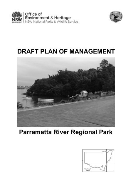
FRONT COVER: Bedlam Bay, <strong>Parramatta</strong> <strong>River</strong> <strong>Regional</strong> <strong>Park</strong><br />
Photo: Isabelle Connolly OEH.<br />
For additional information or any inquiries about this <strong>Park</strong> or this <strong>plan</strong> <strong>of</strong> <strong>management</strong>,<br />
contact the NPWS Valleys Area Office, Lane Cove National <strong>Park</strong>, Lady Game Drive,<br />
Chatswood, NSW, 2067 or by telephone on (02) 8448 0400.<br />
Disclaimer: This publication is for discussion and comment only. Publication indicates the<br />
proposals are under consideration and are open for public discussion. Any statements<br />
made in this <strong>draft</strong> publication are made in good faith and do not render the Office <strong>of</strong><br />
Environment and Heritage (OEH) NSW liable for any loss or damage. Provisions in the<br />
final <strong>management</strong> <strong>plan</strong> may not be the same as those in this <strong>draft</strong> <strong>plan</strong>.<br />
Published by:<br />
Office <strong>of</strong> Environment and Heritage NSW<br />
59–61 Goulburn Street<br />
PO Box A290<br />
Sydney South 1232<br />
© Copyright State <strong>of</strong> NSW and the Office <strong>of</strong> Environment and Heritage NSW: Use<br />
permitted with appropriate acknowledgment.<br />
ISBN 978 1 74359 214 4<br />
OEH 2013/0511<br />
Printed on recycled paper
Invitation to Comment<br />
The National <strong>Park</strong>s and Wildlife Act 1974 (NPW Act) requires that a <strong>plan</strong> <strong>of</strong> <strong>management</strong> be prepared<br />
that outlines how an area will be managed by the NSW National <strong>Park</strong>s and Wildlife Service (NPWS).<br />
The procedures for the exhibition and adoption <strong>of</strong> <strong>plan</strong>s <strong>of</strong> <strong>management</strong> are specified under Part 5 <strong>of</strong><br />
the NPW Act and involve the following stages:<br />
Public exhibition <strong>of</strong> <strong>draft</strong><br />
<strong>plan</strong> for at least 90 days<br />
Plan and submissions to the<br />
<strong>Regional</strong> Advisory<br />
Committee for consideration<br />
Each region has a <strong>Regional</strong> Advisory<br />
Committee whose role is to provide advice<br />
about park <strong>management</strong> and community<br />
perspectives<br />
Plan, submissions and <strong>Regional</strong> Advisory<br />
Committee‟s advice to the National <strong>Park</strong>s<br />
and Wildlife Advisory Council for<br />
consideration<br />
The Advisory Council<br />
advises the Minister<br />
administering the NPW Act. Its<br />
membership is drawn from science,<br />
education, conservation, recreation<br />
and other interest groups<br />
The Advisory Council‟s recommendations referred back to<br />
<strong>Regional</strong> Advisory Committee, which has 30 days to<br />
provide additional comments if desired<br />
After considering the <strong>plan</strong>,<br />
submissions, the recommendations <strong>of</strong> the Advisory<br />
Council and advice from the <strong>Regional</strong> Advisory<br />
Committee, the Minister may adopt the <strong>plan</strong><br />
This <strong>draft</strong> <strong>plan</strong> has been developed with input from key stakeholders and is now being placed on<br />
public exhibition for comment. Members <strong>of</strong> the public, whether as individuals or as members <strong>of</strong><br />
community interest groups, are invited to comment in writing on this <strong>plan</strong> <strong>of</strong> <strong>management</strong>.<br />
The <strong>draft</strong> Plan is on exhibition until Thursday 26 th September 2013.<br />
Submissions can be made by:<br />
i) Writing to: The Area Manager, Valleys Area Office, Lane Cove National <strong>Park</strong>, Lady Game<br />
Drive, Chatswood, NSW, 2067.<br />
ii) Submitting comments on-line at www.environment.nsw.gov.au; or<br />
iii) E-mailing your submission to bedlam.bay@environment.nsw.gov.au<br />
To make consideration <strong>of</strong> your submission as effective as possible it would help us if you:<br />
Identify the section heading and number to which your comment relates; and<br />
Briefly explain the reason for your comment and, if appropriate, suggest other ways to address<br />
the issue.<br />
All submissions received by NPWS are a matter <strong>of</strong> public record and are available for inspection upon<br />
request. Your comments on this <strong>draft</strong> <strong>plan</strong> may contain information that is defined as “personal<br />
information” under the NSW Privacy and Personal Information Protection Act 1998. The submission <strong>of</strong><br />
personal information with your comments is voluntary.
Contents<br />
1. Introduction .................................................................................................................................. 1<br />
1.1 Location, Gazettal and <strong>Regional</strong> Setting .................................................................................. 1<br />
1.2 Statement <strong>of</strong> Significance ........................................................................................................ 1<br />
2. Management Context .................................................................................................................. 3<br />
2.1 Legislative and Policy Framework ............................................................................................ 3<br />
2.2 Management Purposes and Principles ..................................................................................... 4<br />
2.3 Specific Management Directions .............................................................................................. 4<br />
3. Values ......................................................................................................................................... 5<br />
3.1 Geology, Landscape and Hydrology ........................................................................................ 5<br />
3.2 Vegetation Communities and Native Plants ............................................................................. 6<br />
3.3 Native Animals ....................................................................................................................... 11<br />
3.4 Aboriginal Heritage ................................................................................................................ 14<br />
3.5 Historic Heritage .................................................................................................................... 15<br />
3.6 Visitor Use, Information and Education .................................................................................. 20<br />
4. Threats ...................................................................................................................................... 24<br />
4.1 Pests and pathogens ............................................................................................................ 24<br />
4.2 Fire ........................................................................................................................................ 31<br />
4.3 Climate Change ..................................................................................................................... 32<br />
5. Management Operations And Other Uses ................................................................................. 34<br />
5.1 Management Facilities and Operations ................................................................................. 34<br />
5.2 Non-NPWS Uses/Operations ................................................................................................. 37<br />
6. Implementation .......................................................................................................................... 38<br />
ACRONYMS…......................................................................................................................................42<br />
REFERENCES......................................................................................................................................43<br />
i
Map 1: <strong>Parramatta</strong> <strong>River</strong> <strong>Regional</strong> <strong>Park</strong><br />
ii
1.0 Introduction<br />
1.1 Location, gazettal and regional context<br />
Features<br />
Description<br />
<strong>Parramatta</strong> <strong>River</strong> <strong>Regional</strong> <strong>Park</strong><br />
Location<br />
Area<br />
Reservation<br />
Date<br />
Previous<br />
Tenure<br />
<strong>Parramatta</strong> <strong>River</strong> <strong>Regional</strong> <strong>Park</strong> (referred to as „the<br />
<strong>Park</strong>‟ in this <strong>plan</strong>) is located at Bedlam Bay in<br />
Gladesville, approximately 10 kilometres (km) north<br />
west <strong>of</strong> the Sydney Central Business District (CBD) and<br />
16 km east <strong>of</strong> <strong>Parramatta</strong> CBD (see Map 1). The <strong>Park</strong> is<br />
located on the foreshore <strong>of</strong> the northern side <strong>of</strong> the<br />
<strong>Parramatta</strong> <strong>River</strong>, west <strong>of</strong> Gladesville Bridge.<br />
The <strong>Park</strong> covers approximately 4.6 hectares and is long and<br />
narrow in shape, oriented in an east-west direction. The<br />
widest point <strong>of</strong> the <strong>Park</strong> is located at the oval (see Map 1).<br />
The foreshore boundary along the <strong>Parramatta</strong> <strong>River</strong> extends<br />
to the mean high water mark.<br />
The <strong>Park</strong> was gazetted as a <strong>Regional</strong> <strong>Park</strong> on 25 May 2001.<br />
Before the <strong>Park</strong> was transferred to the NPWS in 1998, it<br />
was owned and managed by the then named NSW<br />
Department <strong>of</strong> Health (now NSW Ministry <strong>of</strong> Health).<br />
The <strong>Park</strong> formed part <strong>of</strong> the southern section <strong>of</strong> the<br />
former Gladesville Hospital site that commenced<br />
construction in the late 1830s to care for the mentally ill.<br />
The area that now forms the <strong>Park</strong> was used to access<br />
the hospital by boat, for the production <strong>of</strong> vegetables<br />
and as a location for formal gardens, provided access to<br />
the river for bathing and other sport and recreational<br />
activities and provided a location for sewerage<br />
infrastructure.<br />
<strong>Regional</strong> Context<br />
Biogeographic<br />
Region<br />
Surrounding<br />
Land Use<br />
Other<br />
Authorities<br />
The <strong>Park</strong> is situated within the Sydney Basin Bioregion<br />
along a section <strong>of</strong> the northern foreshore <strong>of</strong> Sydney<br />
Harbour. The <strong>Park</strong> is part <strong>of</strong> a larger network <strong>of</strong><br />
protected lands along the foreshores <strong>of</strong> <strong>Parramatta</strong><br />
<strong>River</strong> and Sydney Harbour.<br />
The <strong>Park</strong> is bounded by the former Gladesville Hospital<br />
site to the north, north-east and north-west. <strong>Parramatta</strong><br />
<strong>River</strong> bounds the <strong>Park</strong> to the south. Punt Road, Banjo<br />
Paterson <strong>Park</strong>, Banjo Paterson Restaurant and a car<br />
park (owned by the NSW Ministry <strong>of</strong> Health but leased by<br />
Ryde City Council) are located to the west <strong>of</strong> the <strong>Park</strong>.<br />
The residential suburb <strong>of</strong> Henley abuts the south-eastern<br />
portion <strong>of</strong> the <strong>Park</strong>.<br />
The <strong>Park</strong> is situated within the areas <strong>of</strong> the Metropolitan<br />
Aboriginal Land Council, Sydney Metropolitan Catchment<br />
Management Authority and Hunters Hill Council.<br />
1
1.2 Statement <strong>of</strong> significance<br />
<strong>Parramatta</strong> <strong>River</strong> <strong>Regional</strong> <strong>Park</strong> is considered to be <strong>of</strong> significance for:<br />
Landscape Values<br />
<br />
The <strong>Park</strong> is located on a significant waterfront location along the <strong>Parramatta</strong> <strong>River</strong><br />
that forms the main tributary and western arm <strong>of</strong> Australia‟s iconic Sydney Harbour.<br />
Visitors to the <strong>Park</strong> can enjoy water views from elevated sections <strong>of</strong> the walking track,<br />
the foreshore and the oval precinct.<br />
<br />
The <strong>Park</strong> forms part <strong>of</strong> a strong cultural landscape particularly when viewed from the<br />
<strong>Parramatta</strong> <strong>River</strong> that demonstrates the built structures and open spaces <strong>of</strong> the<br />
historic Gladesville Hospital from the early nineteenth century up until the present<br />
time.<br />
Biological Values<br />
<br />
<br />
<br />
The <strong>Park</strong> provides habitat along the banks <strong>of</strong> the <strong>Parramatta</strong> <strong>River</strong>, close to the<br />
centre <strong>of</strong> Sydney for native flora and fauna and complements other land reserved for<br />
nature conservation in the Sydney metropolitan area. Habitats include rocky<br />
foreshore, beaches, remnant native vegetation <strong>of</strong> coastal sandstone communities,<br />
mangrove and areas <strong>of</strong> dense introduced vegetation.<br />
The <strong>Park</strong> provides a biodiversity link to nearby reserves and vegetation corridors<br />
including Banjo Paterson <strong>Park</strong> and Looking Glass Bay <strong>Park</strong> to the west and<br />
Gladesville Reserve to the east. The <strong>Park</strong> is also situated within a designated<br />
vegetation corridor that extends from Bedlam Bay in a north-easterly direction<br />
towards <strong>River</strong>glade Reserve, Gladesville Reserve and Tarban Creek Reserve.<br />
The densely vegetated parts <strong>of</strong> the <strong>Park</strong> provide a refuge for small birds that are<br />
uncommon in the urban environment.<br />
Aboriginal Heritage Values<br />
<br />
The <strong>Park</strong> contains evidence <strong>of</strong> Aboriginal occupation including open and shelter<br />
midden sites that <strong>of</strong>fer opportunities to see and better understand aspects <strong>of</strong><br />
Aboriginal cultural practices along the <strong>Parramatta</strong> <strong>River</strong> before European settlement.<br />
Such sites represent a small percentage <strong>of</strong> those that would once have been present<br />
and are therefore a depleted resource and relatively rare (Context 2001).<br />
Historic Heritage Values<br />
<br />
A sandstone cutting, former 1830‟s punt house area and remains <strong>of</strong> the sandstone<br />
wharf at Bedlam Point mark the first section <strong>of</strong> the convict built Great North Road at<br />
the point where the road met the punt across the <strong>Parramatta</strong> <strong>River</strong>. The wharf is<br />
below the high water mark and therefore not located within the <strong>Park</strong>. The Great North<br />
Road remains associated with the punt are a significant representation <strong>of</strong> the early<br />
phases <strong>of</strong> the harbour‟s development and mode <strong>of</strong> transport from the southern shore<br />
to the northern shore. The cable punt was replaced by a ferry service in 1860. Other<br />
portions <strong>of</strong> the Great North Road located outside <strong>of</strong> the <strong>Park</strong> are listed on the World<br />
2
Heritage List, the National Heritage List and the State Heritage Register as the best<br />
surviving examples <strong>of</strong> large-scale convict transportation and colonial expansion<br />
through the presence and labour <strong>of</strong> convicts (UNESCO 2012).<br />
<br />
<br />
<br />
The <strong>Park</strong> forms a significant element <strong>of</strong> a cultural landscape that demonstrates the<br />
setting <strong>of</strong> the Gladesville Hospital site and the changing nature <strong>of</strong> psychiatric health<br />
care overtime. The cultural landscape is <strong>of</strong> exceptional historic significance (Tanner<br />
2000) and the component that forms the <strong>Park</strong> contains physical elements <strong>of</strong> the<br />
Hospital‟s evolution including stone walls, former gardens and botanical <strong>plan</strong>tings,<br />
sewerage infrastructure, the oval, sea walls, amphitheatre, jetty, boat house and<br />
bathing beach.<br />
The jetty and boat house on the foreshores <strong>of</strong> the <strong>Park</strong> formed the original gateway to<br />
the historically significant Gladesville Hospital site until the Gladesville Bridge was<br />
opened in 1884 and Victoria Road became the main point <strong>of</strong> access.<br />
The significance <strong>of</strong> the Great North Road and the former Gladesville hospital site is<br />
partly due to their early construction dates in Australian colonial history, their<br />
intactness and their rarity in demonstrating the early development <strong>of</strong> Sydney.<br />
Recreation and Tourism<br />
<br />
<br />
<br />
<br />
The <strong>Park</strong> provides respite from city living and recreation opportunities on the shores<br />
<strong>of</strong> the iconic landscape <strong>of</strong> Sydney Harbour including a lookout for view appreciation,<br />
public toilets, picnic facilities, walking tracks with interpretation <strong>of</strong> the Aboriginal and<br />
European history <strong>of</strong> the <strong>Park</strong> and asylum, and a sports oval.<br />
The <strong>Park</strong> provides „on-leash‟ dog walking opportunities.<br />
The <strong>Park</strong> is part <strong>of</strong> a regional walking corridor known as the <strong>Parramatta</strong> <strong>River</strong> Walk<br />
that commences at Woolwich Wharf and circulates along the northern side <strong>of</strong> the<br />
Harbour, through Bedlam Bay to <strong>Parramatta</strong> and further afield via a network <strong>of</strong> open<br />
spaces. The <strong>Park</strong> also forms part <strong>of</strong> the Harbour Circle Walk.<br />
The <strong>Park</strong> provides a destination for boating enthusiasts and kayakers who can<br />
access the <strong>Park</strong> and the waterway via the jetty and boat ramp.<br />
2. Management Context<br />
2.1 Legislative and policy framework<br />
The <strong>management</strong> <strong>of</strong> <strong>Regional</strong> <strong>Park</strong>s within New South Wales is in the context <strong>of</strong> a legislative<br />
and policy framework, primarily the National <strong>Park</strong>s and Wildlife Act 1974 (NPW Act) and<br />
Regulation, the Threatened Species Conservation Act 1995 (TSC Act) and the policies <strong>of</strong> the<br />
National <strong>Park</strong>s and Wildlife Service (NPWS).<br />
Other legislation, international agreements and strategies may also apply to <strong>management</strong> <strong>of</strong><br />
the area. In particular, the Environmental Planning and Assessment Act 1979 (EPA Act) may<br />
require assessment <strong>of</strong> the environmental impact <strong>of</strong> works proposed in this <strong>plan</strong>. Given the<br />
<strong>Park</strong> was part <strong>of</strong> the Gladesville Hospital site and is located on the foreshores <strong>of</strong> Sydney<br />
Harbour, the <strong>Park</strong> also needs to be managed in accordance with the objectives under the<br />
Sydney <strong>Regional</strong> Environment Plan (Sydney Harbour Catchment) 2005 (SREP) and the<br />
stated <strong>plan</strong>ning principles.<br />
3
The Commonwealth Environment Protection and Biodiversity Conservation Act 1999 (EPBC<br />
Act) may apply in relation to actions that impact on matters <strong>of</strong> National Environmental<br />
Significance, such as migratory and threatened species listed under that Act.<br />
A <strong>plan</strong> <strong>of</strong> <strong>management</strong> is a statutory document under the NPW Act. Once the Minister has<br />
adopted a <strong>plan</strong>, the <strong>plan</strong> must be carried out and no operations may be undertaken within<br />
<strong>Parramatta</strong> <strong>River</strong> <strong>Regional</strong> <strong>Park</strong> except in accordance with this <strong>plan</strong>. This <strong>plan</strong> will also apply<br />
to any future additions to the <strong>Park</strong>. Should <strong>management</strong> strategies or works be proposed for<br />
the <strong>Park</strong> that are not consistent with this <strong>plan</strong>, an amendment to the <strong>plan</strong> will be required.<br />
2.2 Management purposes and principles<br />
<strong>Regional</strong> parks are reserved under the NPW Act to protect and conserve areas in a natural<br />
or modified landscape that are suitable for public recreation and enjoyment.<br />
Under the Act (section 30H), regional parks are managed to:<br />
<br />
<br />
<br />
<br />
<br />
<br />
provide opportunities for recreation and enjoyment in natural or modified landscapes;<br />
identify, interpret, manage and conserve the <strong>Park</strong> so as to maintain and enhance<br />
significant landscape values;<br />
conserve natural and cultural values;<br />
promote public appreciation and understanding <strong>of</strong> the <strong>Park</strong>‟s natural and cultural<br />
values;<br />
provide for sustainable visitor or tourist use and enjoyment that is compatible with<br />
conservation <strong>of</strong> natural and cultural values; and<br />
provide for sustainable use (including adaptive reuse) <strong>of</strong> any buildings or structures or<br />
modified natural areas having regard to conservation <strong>of</strong> natural and cultural values.<br />
2.3 Specific Management Directions<br />
In addition to the general principles for the <strong>management</strong> <strong>of</strong> regional parks (refer section 2.2),<br />
the following specific <strong>management</strong> directions apply to the <strong>management</strong> <strong>of</strong> <strong>Parramatta</strong> <strong>River</strong><br />
<strong>Regional</strong> <strong>Park</strong>:<br />
<br />
<br />
<br />
promote visitor and community appreciation <strong>of</strong> the natural and cultural heritage<br />
values <strong>of</strong> the park, in addition to its values as a recreation area;<br />
recognise and protect traditional and contemporary Aboriginal cultural heritage,<br />
landscape and spiritual values by providing opportunities for the traditional owners<br />
and the local Aboriginal community to help identify, protect, interpret and manage the<br />
<strong>Park</strong>‟s heritage values;<br />
protect and enhance the <strong>Park</strong>‟s non-indigenous heritage values including structures,<br />
the cultural landscape, significant remnant heritage <strong>plan</strong>tings and view corridors;<br />
4
work with local community groups and volunteers to enhance and conserve the<br />
natural and cultural heritage values <strong>of</strong> the <strong>Park</strong>;<br />
consider practical and site based measures to protect the foreshore and the<br />
associated heritage values from sea level rise;<br />
participate, as required, as a stakeholder during discussion and <strong>plan</strong>ning regarding<br />
future works and use <strong>of</strong> the Bedlam Bay area and the broader Gladesville Hospital<br />
site; and<br />
explore options for possible future leasing <strong>of</strong> part <strong>of</strong> the <strong>Park</strong> for increased<br />
recreational and sporting activities.<br />
3.0 Values<br />
This <strong>plan</strong> aims to conserve the natural, cultural and recreational values <strong>of</strong> <strong>Parramatta</strong> <strong>River</strong><br />
<strong>Regional</strong> <strong>Park</strong>. These values may be attached to the landscape as a whole or to individual<br />
components <strong>of</strong> the landscape, for example to <strong>plan</strong>t and animal species used by Aboriginal<br />
people.<br />
3.1 Geology, Landscape and Hydrology<br />
The <strong>Park</strong> is located in the Sydney Basin and is situated on the northern foreshore <strong>of</strong> the<br />
<strong>Parramatta</strong> <strong>River</strong>, a drowned river valley that forms the main tributary and western arm <strong>of</strong><br />
Sydney Harbour. The <strong>Park</strong> comprises a crescent shaped ridge enclosing a south facing<br />
valley and a riverside bay known as Bedlam Bay.<br />
The <strong>Park</strong> overlies Hawkesbury Sandstone (a sedimentary rock dating from the Triassic<br />
period 252.2 ± 0.5 to 201.3 ± 0.2 million years ago) (Chapman et al. 1989). In the west <strong>of</strong> the<br />
park, this geology results in rugged to undulating valley sides that are typical <strong>of</strong> the Harbour<br />
foreshore. Slopes tend to be greater than 25% gradient with rock outcrops, rocky benches,<br />
broken scarps and boulders (Chapman et al. 1989). The eastern portion <strong>of</strong> the <strong>Park</strong> is flat to<br />
undulating primarily as a result <strong>of</strong> the construction <strong>of</strong> the oval.<br />
Soils in the <strong>Park</strong> are shallow discontinuous lithosols (a soil where the B horizon directly<br />
overlies hard rock and contains rock fragments) and siliceous sands (sands high in silica)<br />
associated with rocky outcrops. Soils are typically stony and highly permeable with low soil<br />
fertility. Abundant organic matter as a result <strong>of</strong> thick weed growth and a south facing aspect<br />
has resulted in a darker topsoil colour which becomes lighter with depth. Soil pH in the park<br />
ranges from strongly acid to slightly acid (Chapman et al. 1989).<br />
Prior to colonisation, the <strong>Park</strong> comprised open woodland and tall open forest (Chapman et<br />
al.1989). Since colonisation, extensive modification <strong>of</strong> the natural landforms, soils and<br />
hydrological processes has occurred. These modifications include the construction <strong>of</strong> sea<br />
walls, sewerage and drainage infrastructure and terraces. Land reclamation and the<br />
dumping <strong>of</strong> rubbish from the Gladesville hospital have also contributed to the change in the<br />
natural contours in some places (Context 2001). The area immediately behind the former<br />
bathing beach may be unstable due to an accumulation <strong>of</strong> refuse including building rubble<br />
that may comprise contaminants, although weed growth is currently stabilising the area.<br />
The <strong>Park</strong> is a small catchment <strong>of</strong> the <strong>Parramatta</strong> <strong>River</strong> that is bounded by Punt Road,<br />
Victoria Road and the Gladesville Hospital site. A large stormwater outlet is located adjacent<br />
to the boat shed that drains water from the Gladesville hospital site. It originates near the<br />
former tennis courts at the top <strong>of</strong> the oval and circulates under the oval to the outlet. Disused<br />
5
sewerage infrastructure, comprising settling ponds partly filled with clean rubble, is located in<br />
the western section <strong>of</strong> the <strong>Park</strong>. There are several minor drainage pipelines within the <strong>Park</strong><br />
including a drain near the former bathing beach that may originate from the swimming pool<br />
within the hospital grounds and an old clay pipeline on the beach nearest to the former punt<br />
ruins.<br />
Issues:<br />
The oval and the oval foreshore have been identified as being affected by “class 2”<br />
acid sulphate soils within the Hunters Hill Council Local Environmental Plan (LEP)<br />
2012. Any works in this vicinity will need to be carried out in accordance with Acid<br />
Sulphate soil <strong>management</strong> guidelines.<br />
<br />
<br />
<br />
<br />
<br />
The oval is constructed on fill <strong>of</strong> unknown origin that may contain contaminants. No<br />
studies have been conducted to date to determine the contaminants.<br />
An AECOM Australia study on the „<strong>Parramatta</strong> <strong>River</strong> Estuary Processes‟ in 2010 has<br />
indicated that in the absence <strong>of</strong> comprehensive and consistent data relating to<br />
stormwater <strong>management</strong> devices, the Bedlam Bay sub-catchment may require<br />
additional gross pollutant <strong>management</strong> (AECOM 2010).<br />
The <strong>Parramatta</strong> <strong>River</strong> is widely known to have been stressed over the last two<br />
centuries by pollution draining into the river, particularly pre 1970. As a result, the<br />
river‟s embankments and sediments are known to be contaminated with a range <strong>of</strong><br />
heavy metals and chemicals including organochlorine compounds and polycyclic<br />
aromatic hydrocarbons (PAHs) that are among the highest reported in the world<br />
(AECOM 2010). The nearby Halmey mill located at the end <strong>of</strong> Punt Road on the edge<br />
<strong>of</strong> Looking Glass Bay manufactured linseed oil, lead paint, varnish, putties, caulking<br />
compounds, printing inks and linoleum from 1923 to 1974 and may have contributed<br />
to localised contamination. Contaminated sediments in the river have resulted in a<br />
commercial fishing ban throughout Sydney Harbour and its tributaries, including the<br />
<strong>Parramatta</strong> <strong>River</strong> (AECOM 2010). A sign has been erected at the western entrance to<br />
the <strong>Park</strong> advising recreational fishermen on the health <strong>of</strong> the river and its seafood and<br />
states limits on consumption. Bedlam Bay is listed as a low priority for remediation<br />
works on sediments in the Draft <strong>Parramatta</strong> <strong>River</strong> Estuary Coastal Zone Management<br />
Plan (Cardno 2012).<br />
Rock outcrops and soils including unpaved tracks are prone to soil erosion and<br />
potential rock falls, particularly during heavy rainfall (Chapman et al. 1989). The two<br />
beaches, rock platforms and vegetated and non-vegetated shoreline areas are also<br />
vulnerable to short duration erosion events caused by severe storms, vessel wash,<br />
flooding, high tides and informal public access. Longer-term recession or accretion<br />
may also destabilise banks and can be caused by changes to mean sea-level,<br />
sediment availability, and changes in river hydrodynamics due to foreshore and<br />
channel realignment and dredging (AECOM 2010). Currently there is evidence <strong>of</strong><br />
foreshore erosion at the beach on the eastern side <strong>of</strong> the <strong>Park</strong> although woody weeds<br />
are partially retaining the shore and preventing erosion.<br />
Currently there is no co-ordinated, catchment-wide Plan with sufficient technical detail<br />
to guide the improvement <strong>of</strong> water quality from all the catchments draining to Sydney<br />
Harbour. The Sydney Metropolitan Catchment Management Authority is working to<br />
improve the health <strong>of</strong> Sydney Harbour and its catchment with a Water Quality<br />
Improvement Plan to assist local councils and government agencies in the<br />
catchment.<br />
6
Desired Outcomes:<br />
<br />
<br />
<br />
Exposure <strong>of</strong> acid sulphate soil is avoided in accordance with acid sulphate soils<br />
<strong>management</strong> guidelines.<br />
Soil erosion and subsidence is minimised, areas prone to foreshore erosion and<br />
areas previously used for dumping and reclamation are stabilised and risks from<br />
contaminants are mitigated.<br />
Environmental impacts to the <strong>Parramatta</strong> <strong>River</strong> are co-operatively reduced.<br />
Management Response:<br />
3.1.1 Prepare an acid sulphate soils <strong>management</strong> <strong>plan</strong> for all major works on the oval in<br />
accordance with the NSW Acid Sulphate Soils Manual.<br />
Ongoing<br />
3.1.2 Risk assess the <strong>Park</strong> for stability <strong>of</strong> lands and contaminants and implement<br />
recommendations as required.<br />
High priority<br />
3.1.3 Contribute to any multi-agency initiatives to improve the water quality and health <strong>of</strong><br />
Sydney Harbour and its catchment.<br />
Medium priority<br />
3.2 Vegetation Communities and Native Plants<br />
<strong>Parramatta</strong> <strong>River</strong> <strong>Regional</strong> <strong>Park</strong> is located in the Sydney Basin bioregion, biogeographic subregion<br />
<strong>of</strong> Pittwater, and the Mitchell Landscape known as Port Jackson Basin (NPWS 2012).<br />
Since European settlement, the majority <strong>of</strong> bushland in the surrounding area <strong>of</strong> Hunters Hill<br />
and Gladesville has been cleared for urban development (Hunters Hill Council 2012a). Most<br />
<strong>of</strong> the remaining vegetation on <strong>Park</strong> has also altered significantly due to past clearing, weed<br />
invasion, increased nutrients, changed hydrology, botanical <strong>plan</strong>tings and construction <strong>of</strong> the<br />
oval and sea walls.<br />
The vegetation communities that originally existed on <strong>Park</strong> probably included rocky foreshore<br />
vegetation dominated by Port Jackson figs (Ficus rubiginosa) and coast banksia (Banksia<br />
integrifolia) which is now considered locally significant (Hunters Hill Council 2012a). The<br />
<strong>Park</strong> still contains mature F. rubiginosa west <strong>of</strong> the oval. Other former vegetation may have<br />
included open forest, woodland, heath and shrubland communities on Hawkesbury<br />
sandstone (Hunters Hill Council 2012a).<br />
There have been no flora surveys or vegetation surveys <strong>of</strong> the <strong>Park</strong> to determine the<br />
existence <strong>of</strong> threatened flora species or to confirm the extent <strong>of</strong> threatened ecological<br />
communities. However, broad scale studies <strong>of</strong> vegetation along the <strong>Parramatta</strong> <strong>River</strong> and<br />
across the Sydney Metropolitan Catchment Authority Area (SMCMA) provide information on<br />
the vegetation communities that currently occur within the <strong>Park</strong>.<br />
Vegetation mapping in the Draft Native Vegetation <strong>of</strong> the Sydney Metropolitan Catchment<br />
Management Authority Area (DECCW 2009) identifies two native vegetation communities<br />
within the park:<br />
- Coastal tea-tree-banksia scrub (forms the majority <strong>of</strong> the area <strong>of</strong> native vegetation within<br />
the park); and<br />
- A small pocket <strong>of</strong> estuarine swamp oak forest (occurs between the oval and the bathing<br />
beach where the lookout is situated (see Map 1));<br />
7
Estuarine swamp oak forest is a sub-type <strong>of</strong> Swamp-oak floodplain forest <strong>of</strong> the NSW North<br />
Coast, Sydney Basin and South East Corner bioregions which is listed as an endangered<br />
ecological community (EEC) under Part 3 <strong>of</strong> Schedule 1 <strong>of</strong> the TSC Act. This pocket <strong>of</strong><br />
vegetation is heavily infested with weeds and is dominated by sweet pittosporum<br />
(Pittosporum undulatum) in the understory and further investigation is needed to determine<br />
whether it meets the definition <strong>of</strong> the EEC.<br />
A single Grey Mangrove (Avicennia marina) grows on the former bathing beach outside <strong>of</strong><br />
the park. It is a single representative <strong>of</strong> the estuarine mangrove forest community and is a<br />
species typical <strong>of</strong> mangrove communities in the Sydney region and the most widespread<br />
component <strong>of</strong> estuarine vegetation within the <strong>Parramatta</strong> <strong>River</strong> (DECCW 2009; AECOM<br />
Australia Pty Ltd 2010). Mangroves are protected under the Fisheries Management Act 1994<br />
(FM Act) (AECOM 2010).<br />
In addition to the three native vegetation communities mapped by DECCW (2009), a recent<br />
avifauna survey report for the <strong>River</strong> to <strong>River</strong> Project suggests that the <strong>Park</strong> contains isolated<br />
patches <strong>of</strong> Sydney turpentine-ironbark forest (Insight Ecology 2011), which is listed as an<br />
endangered ecological community (EEC) under Part 3 <strong>of</strong> Schedule 1 <strong>of</strong> the TSC Act and as<br />
a critically endangered ecological community under the EPBC Act (1999). Detailed<br />
investigation is required to determine whether this threatened ecological community occurs<br />
within the reserve in order to derive appropriate <strong>management</strong> responses.<br />
In the north-west and south-east <strong>of</strong> the <strong>Park</strong>, two areas have been mapped as urban<br />
exotic/native and as weeds (DECCW 2009).<br />
Although bush regeneration and re-vegetation with endemic species has occurred at the<br />
western entrance to the <strong>Park</strong> <strong>of</strong>f Punt Road and along walking tracks, the western portion <strong>of</strong><br />
the <strong>Park</strong> is subject to heavy weed infestation. Native <strong>plan</strong>t species in the western entrance<br />
to the <strong>Park</strong> and the rocky foreshore west <strong>of</strong> the oval include a canopy <strong>of</strong> blackbutt<br />
(Eucalyptus pilularis), mature non-endemic brush box (Lophostemon confertus) <strong>plan</strong>ted as<br />
part <strong>of</strong> past landscaping works and sweet pittosporum (P. undulatum). The dominant native<br />
species in the middle and understory are blueberry ash (Elaeocarpus reticulatus), black sheoak<br />
(Allocasuarina littoralis), cheese tree (Glochidion ferdinandi), coast myall (Acacia<br />
binervia), hickory wattle (Acacia implexa), coast banksia (Banksia integrifolia), spiny-head<br />
mat-rush (Lomandra longifolia), c<strong>of</strong>fee bush (Breynia oblongifolia), weeping grass<br />
(Microlaena stipoides) and dianella spp.<br />
The remainder <strong>of</strong> the <strong>Park</strong> primarily comprises weeds and landscape <strong>plan</strong>tings as part <strong>of</strong> the<br />
former gardens <strong>of</strong> the hospital, with a number <strong>of</strong> mature endemic F. rubiginosas scattered<br />
throughout the <strong>Park</strong>. Some <strong>of</strong> the landscape <strong>plan</strong>tings may have heritage significance and<br />
are discussed in more detail in sections 3.5 and 4.1. Some revegetation with native species<br />
including L. longifolia) and water vine (Cissus antarctica) has occurred along designated<br />
pathways within the <strong>Park</strong>.<br />
Remnant vegetation on <strong>Park</strong> is significant at a regional scale because <strong>of</strong> the extent <strong>of</strong><br />
suburban development in the Sydney Basin. The <strong>Park</strong> provides a vegetated link for<br />
biodiversity to nearby reserves and other vegetation corridors including Banjo Paterson <strong>Park</strong><br />
and Looking Glass Bay <strong>Park</strong> to the west and Gladesville Reserve to the east. Collectively<br />
these comprise landscaped open parkland and bushland along the <strong>River</strong> foreshore. It should<br />
be noted that in such an altered landscape any vegetation, native or exotic, is likely make a<br />
positive contribution towards biodiversity as a food source, shelter and a habitat corridor.<br />
The <strong>Park</strong> is also situated within a designated vegetation corridor between the <strong>Parramatta</strong><br />
<strong>River</strong> and Lane Cove <strong>River</strong>. This corridor is being enhanced by the SMCMA and local<br />
councils as part <strong>of</strong> the <strong>River</strong> to <strong>River</strong> Corridors Project. The corridor will extend from<br />
8
<strong>Parramatta</strong> <strong>River</strong> <strong>Regional</strong> <strong>Park</strong>, in a north-easterly direction towards <strong>River</strong>glade Reserve,<br />
Gladesville Reserve and Tarban Creek Reserve. The corridor should enhance habitats for<br />
birds and other fauna and reconnect and rehabilitate fragmented bushland (Ryde City<br />
Council 2012a).<br />
Although no records for threatened <strong>plan</strong>t species have been identified for the <strong>Park</strong>, Table 1<br />
indicates the threatened species and locally significant <strong>plan</strong>t species known to exist within a<br />
5 kilometre radius <strong>of</strong> the <strong>Park</strong> since the 1980s that could occur within the <strong>Park</strong>.<br />
Table 1 Threatened flora species with a potential to exist in <strong>Parramatta</strong> <strong>River</strong> <strong>Regional</strong><br />
<strong>Park</strong><br />
Common Name Scientific Name Status<br />
Darwinia biflora<br />
TSC Act: Vulnerable<br />
Bauer‟s Midge Orchid Genoplesium baueri TSC Act: Vulnerable<br />
Epacris purpurascens var. TSC Act: Vulnerable<br />
purpurascens<br />
Pimelea curviflora var. curviflora TSC Act: Vulnerable<br />
Magenta Lilly Pilly Syzygium paniculatum TSC Act: Vulnerable<br />
Wilsonia backhousei (unlikely to TSC Act: Vulnerable<br />
occur)<br />
Fungi Camarophyllopsis kearneyi TSC Act: Endangered<br />
Fungi<br />
Hygrocybe anomala var. TSC Act: Vulnerable<br />
ianthinamarginata<br />
Fungi Hygrocybe aurantipes TSC Act: Vulnerable<br />
Fungi Hygrocybe austropratensis TSC Act: Endangered<br />
Fungi Hygrocybe lanecovensis TSC Act: Endangered<br />
Fungi Hygrocybe reesiae TSC Act: Vulnerable<br />
Fungi Hygrocybe rubronivea TSC Act: Vulnerable<br />
Source: Hunters Hill Council 2012a and OEH Wildlife Atlas 2012<br />
Strategies for the recovery <strong>of</strong> threatened species and ecological communities have been set<br />
out in the state-wide threatened species priorities action statements (PAS). If threatened<br />
species are found in the <strong>Park</strong>, existing individual recovery <strong>plan</strong>s and best practice guidelines<br />
for recovery <strong>of</strong> threatened species will be implemented. The PAS for threatened ecological<br />
communities and best practice guidelines will be implemented and used to guide restoration<br />
<strong>of</strong> these communities.<br />
Issues:<br />
<br />
<br />
<br />
<br />
No systematic flora surveys, targeted threatened <strong>plan</strong>t surveys or on site assessment<br />
<strong>of</strong> threatened ecological communities have been conducted on <strong>Park</strong>. These studies<br />
are required in order to appropriately prioritise weed and other <strong>management</strong><br />
responses in remnant vegetation on <strong>Park</strong>, particularly where these may be EECs.<br />
The bushland within the <strong>Park</strong> is only capable <strong>of</strong> limited recovery due to disturbance<br />
over the last 150 years.<br />
All <strong>plan</strong>s for revegetation, weed <strong>management</strong> and landscape conservation works in<br />
the <strong>Park</strong> will need to be prepared in the context <strong>of</strong> the larger landscape <strong>plan</strong>ning<br />
framework <strong>of</strong> the <strong>River</strong> to <strong>River</strong> Corridors Project by Hunters Hill and Ryde Councils<br />
and the SMCMA, and the need to enhance the structural complexity <strong>of</strong> the vegetation<br />
and therefore improve fauna habitat.<br />
There is extensive weed infestation in the <strong>Park</strong>.<br />
9
The Bedlam Bay community bush regeneration group will require a level <strong>of</strong> ongoing<br />
support from suitably trained and experienced supervisors.<br />
Trampling <strong>of</strong> native vegetation by <strong>of</strong>f-track walking is impacting on the ability <strong>of</strong> the<br />
bush to regenerate in some areas and on the success <strong>of</strong> supplementary <strong>plan</strong>ting.<br />
Desired Outcomes:<br />
<br />
<br />
<br />
The habitat and populations <strong>of</strong> native <strong>plan</strong>ts and in particular any threatened <strong>plan</strong>t<br />
species and/or ecological communities are protected, maintained and enhanced.<br />
Biodiversity restoration works improve native vegetation linkages along the foreshore<br />
and between the <strong>Parramatta</strong> and Lane Cove <strong>River</strong>s as part <strong>of</strong> the <strong>River</strong> to <strong>River</strong><br />
Corridors Project.<br />
The recreation values, cultural landscape and view corridors are considered and<br />
retained where suitable when revegetating and weeding.<br />
Management Response:<br />
3.2.1 Confirm the presence and location <strong>of</strong> threatened species and EECs within the <strong>Park</strong>.<br />
High priority<br />
3.2.2 Identify all <strong>plan</strong>tings within the <strong>Park</strong> that have historic and or cultural significance.<br />
Medium priority<br />
3.2.3 Implement relevant strategies in the PAS, recovery <strong>plan</strong>s and best practice guidelines<br />
for any threatened species and ecological communities present in the <strong>Park</strong>. Ongoing<br />
3.2.4 Continue to support opportunities to research vegetation and monitor flora and fauna<br />
in partnership with educational institutions.<br />
Ongoing<br />
3.2.5 Manage visitor impacts on bushland and regenerating areas. Ongoing<br />
3.2.6 Support and promote restoration <strong>of</strong> degraded areas by local Bushcare groups.<br />
Ongoing<br />
3.2.7 Support any multi agency initiatives to improve vegetation condition in the <strong>River</strong> to<br />
<strong>River</strong> Corridors Project.<br />
Ongoing<br />
3.3 Native Animals<br />
Habitat isolation and fragmentation as well as urban and industrial development along the<br />
length <strong>of</strong> the <strong>Parramatta</strong> <strong>River</strong> have had a severe impact on the number and diversity <strong>of</strong><br />
native animals. Habitat loss, predation by feral and domestic animals and weed infestation<br />
have meant that previously common species are now rarely seen within and along the river.<br />
However, the <strong>Park</strong> provides habitat along the banks <strong>of</strong> the <strong>Parramatta</strong> <strong>River</strong> for native fauna<br />
and complements other land reserved for nature conservation in the Sydney metropolitan<br />
area. Potential terrestrial habitats include rocky foreshore, open grassed areas, dense nonendemic<br />
vegetation and remnant native vegetation <strong>of</strong> coastal sandstone communities that<br />
are inhabited by birds, insects, frogs, reptiles and small mammals. The small regenerating<br />
mangrove community potentially provides habitat for fish and sea birds whilst the beaches,<br />
rock platform and pools, sea walls and jetty pylons provide surfaces for colonisation by<br />
benthic organisms (Wiecek 2009, AECOM Australia Pty Ltd 2010).<br />
In 2011, Ryde City Council commissioned a bird survey for the <strong>River</strong> to <strong>River</strong>s Corridor<br />
10
project. Fifty-six bird species were recorded between the two rivers in the Ryde and Hunters<br />
Hill local Government Areas. The study demonstrated the importance <strong>of</strong> bushland remnants<br />
whereby 44 <strong>of</strong> the 56 bird species recorded in the survey were found in bushland (Insight<br />
Ecology 2011).<br />
During the survey, a variety <strong>of</strong> small birds that are rare in the urban environment and more<br />
open landscapes were found within the <strong>Park</strong>, particularly within the dense weedy areas.<br />
These small birds are generally not found in the adjoining Banjo Paterson <strong>Park</strong> or the<br />
Gladesville Hospital site as they are too open to provide protection and habitat. Small native<br />
birds are <strong>of</strong> conservation significance in the urban environment due to population declines in<br />
urban areas. Within the <strong>Park</strong>, breeding groups <strong>of</strong> white-browed scrubwrens (Sericornis<br />
frontalis), variegated fairy-wrens (Malurus lamberti) and superb fairy-wrens (Malurus<br />
cyaneus) were found foraging along with rufous fantails (Rhipidura rufifrons) (Insight Ecology<br />
2011). Local bird watchers have also identified red-browed finches (Neochmia temporalis)<br />
and silvereyes (Zosterops lateralis) within the weedy areas (Debrincat 2011a and b).<br />
More common birds found in the local urban environment that are likely to exist within the<br />
<strong>Park</strong> include: spotted turtle-dove (Spilopelia chinensis), galah (Eolophus roseicapilla),<br />
sulphur-crested cockatoo (Cacatua galerita), long-billed corella (Cacatua tenuirostris), willie<br />
wagtail (Rhipidura leucophrys), masked lapwing (Vanellus miles), Australian raven (Corvus<br />
coronoides), Australian white ibis (Threskiornis molucca), silver gull (Chroicocephalus<br />
novaehollandiae), pied currawong (Strepera graculina), laughing kookaburra (Dacelo<br />
novaeguineae), grey butcherbird (Cracticus torquatus), welcome swallow (Hirundo neoxena),<br />
crested pigeon (Ocyphaps lophotes), magpie-lark (Grallina cyanoleuca), australian magpie<br />
(Gymnorhina tibicen), noisy miner (Manorina melanocephala), rainbow lorikeet<br />
(Trichoglossus haematodus) and the introduced rock dove (Columba livia) and common<br />
myna (Acridotheres tristis) (Insight Ecology 2011).<br />
Bedlam Bay, along with other foreshore parks, also provides habitats and functions as a<br />
corridor for the movement <strong>of</strong> migratory and nomadic birds such as flycatchers, gerygones,<br />
cuckoos and honeyeaters (Insight Ecology 2011).<br />
Although there are no fauna records on OEH NSW Wildlife Atlas (OEH 2012) for the <strong>Park</strong>,<br />
records for the surrounding area inform what could exist within the <strong>Park</strong>. Twenty-one species<br />
listed under either or all three international conservation agreements – China-Australia<br />
Migratory Bird Agreement (CAMBA), Japan-Australia Migratory Bird Agreement (JAMBA)<br />
and Republic <strong>of</strong> Korea-Australia Migratory Bird Agreement (ROKAMBA) – have been<br />
recorded in the Hunters Hill Local Government area over the past 27 years and may<br />
occasionally frequent the park. These include intercontinental migratory waders that arrive in<br />
spring in Australia and depart in autumn for their northern Asian breeding grounds. They also<br />
include White-throated Needletail (Hirundapus caudacutus), Fork-tailed Swift (Apus<br />
pacificus), White-bellied Sea-Eagle (Haliaeetus leucogaster), Cattle Egret (Bubulcus ibis),<br />
Eastern Great Egret (Ardea alba modesta), Crested Tern (Sterna bergi), Common Tern<br />
(Sterna hirundo) and Oriental Cuckoo (Cuculus optatus) (Insight Ecology 2010).<br />
No fauna species listed as endangered or vulnerable under the Commonwealth Environment<br />
Protection and Biodiversity Conservation Act 1999 or the Threatened Species Conservation<br />
Act 1995 has been recorded in the <strong>Park</strong>. The species listed in Table 2 below have been<br />
previously recorded within a 5 km radius <strong>of</strong> the <strong>Park</strong>.<br />
11
Table 2: Endangered or Vulnerable Species recorded near Bedlam Bay<br />
Scientific name Common name Status<br />
Xanthomyza phrygia Regent Honeyeater EPBC Act: Endangered<br />
TSC Act: Endangered<br />
Ninox connivens Barking Owl TSC Act: Vulnerable<br />
Ninox strenua Powerful Owl TSC Act: Vulnerable<br />
Pseudophryne australis Red-crowned Toadlet TSC Act: Vulnerable<br />
Pteropus poliocephalus Grey-headed Flying-fox EPBC Act: Vulnerable<br />
TSC Act: Vulnerable<br />
Miniopterus schreibersii Eastern Bent-wing Bat TSC Act: Vulnerable<br />
oceanensis<br />
Ixobrychus flavicollis Black Bittern TSC Act: Vulnerable<br />
Limosa limosa Black-tailed Godwit TSC Act: Vulnerable<br />
Burhinus grallarius Bush Stone-curlew* TSC Act: Endangered<br />
Pandion cristatus Eastern Osprey TSC Act: Vulnerable<br />
Glossopsitta pusilla Little Lorikeet TSC Act: Proposed<br />
Vulnerable<br />
Sternula albifrons Little Tern TSC Act: Endangered<br />
Haematopus longirostris Pied Oystercatcher TSC Act: Endangered<br />
Ptilinopus superbus Superb fruit-dove* TSC Act: Vulnerable<br />
Daphoenositta chrysoptera Varied Sitella TSC Act: Vulnerable<br />
Cercartetus nanus Eastern Pygmy Possum TSC Act: Vulnerable<br />
Miniopterus australis Little Bentwing Bat TSC Act: Vulnerable<br />
Perameles nasuta Long-nosed Bandicoot TSC Act: Endangered<br />
Population<br />
Anthochaera phrygia Regent Honeyeater EPBC Act: Endangered<br />
TSC Act: Critically<br />
Endangered<br />
Saccolaimus flaviventris Yellow-bellied Sheathtail Bat TSC Act: Vulnerable<br />
Hoplocephalus bungaroides Broad-headed Snake* EPBC Act: Vulnerable<br />
TSC Act: Endangered<br />
Source: Insight Ecology 2011, OEH NSW Wildlife Atlas September 2012.<br />
*likely to be locally extinct<br />
Other species observed within the <strong>Park</strong> include the blue tongue lizard (Tiliqua scincoides),<br />
red bellied black snake (Pseudechis porphyriacus), a variety <strong>of</strong> skinks, ring-tailed possums<br />
(Pseudocheirus peregrinus) and brush-tailed possums (Trichosurus vulpecula). A 1998 study<br />
by Perkins also noted the sighting <strong>of</strong> water rats (Hydromys chrysogaster) on the nearby<br />
foreshores <strong>of</strong> the <strong>Parramatta</strong> <strong>River</strong>.<br />
The animal groups most seriously affected by land clearing and urban development in the<br />
area are terrestrial mammals, large reptiles and frogs. Terrestrial mammals (such as native<br />
rodents, bandicoots and wombats) are likely to have completely disappeared. Large reptiles<br />
have also been extensively eliminated. This includes goannas, large snakes, dragons (such<br />
as Bearded Dragons – Pogona barbatus) and large skinks (such as Blue-tongue lizards<br />
(Tiliqua scincoides). The Long-necked Tortoise (Chelodina longicollis) and the Short-beaked<br />
Echidna (Tachyglossus aculeatus) are also locally rare (Hunters Hill Council 2012b). Frogs<br />
have suffered a significant decline whereby most reserves have just one or two species. This<br />
is partly due to loss <strong>of</strong> habitat, poor water quality and predation (Biosphere Environmental<br />
Consultants 2008).<br />
12
Issues:<br />
<br />
<br />
<br />
<br />
<br />
Limited fauna surveys have been conducted in the reserve and as such there is a<br />
lack <strong>of</strong> detailed fauna data for the park.<br />
In the Ryde-Hunters Hill area, birds such as spotted quail-thrush (Cinclosoma<br />
punctatum), eastern bristlebird (Dasyornis brachypterus), speckled warbler<br />
(Pyrrholaemus sagittatus), superb lyrebird (Menura novaehollandiae), rockwarbler<br />
(Origma solitaria) and white- fronted Chat (Epthianura albifrons) have become extinct.<br />
Other bushland bird species, particularly small birds, appear to be currently in<br />
population decline, placing them at risk <strong>of</strong> local extinction.<br />
Dense, weed-dominated vegetation within the <strong>Park</strong> provides movement corridors as<br />
well as feeding, roosting and breeding habitat for small birds that are locally rare.<br />
Weeding activities may compromise small bird habitat. Sensitive weeding strategies<br />
which take a staged approach and promote dense native vegetation adjacent to<br />
weeded areas will be needed if extinction <strong>of</strong> small birds in the local area is to be<br />
avoided.<br />
Predation by exotic animals such as foxes, cats and dogs has been a major cause for<br />
the widespread loss <strong>of</strong> terrestrial mammals in the area. Visitors can also impact upon<br />
native fauna through disturbance and the presence <strong>of</strong> dogs.<br />
Optimum fauna biodiversity in the park is dependant on managing pests, habitat<br />
fragmentation and habitat degradation.<br />
Desired Outcomes:<br />
<br />
<br />
The habitat and populations <strong>of</strong> native fauna species in the <strong>Park</strong> are identified and<br />
conserved.<br />
Negative impacts on the habitat <strong>of</strong> threatened species and locally rare or significant<br />
species within the <strong>Park</strong> are minimised.<br />
Management Response:<br />
3.3.1 Implement relevant strategies in the PAS, recovery <strong>plan</strong>s and best practice guidelines<br />
for any threatened species recorded in the <strong>Park</strong>.<br />
Ongoing<br />
3.3.2 Protect habitats <strong>of</strong> all native fauna, including threatened or regionally significant<br />
species from visitor impacts, effects <strong>of</strong> introduced species or aggressive native<br />
species, inappropriate fire and weed removal regimes and other adverse impacts.<br />
Ongoing<br />
3.3.3 Contribute to any multi agency initiatives to improve habitat corridor linkages within<br />
and immediately surrounding the park, including the <strong>River</strong> to <strong>River</strong> Corridors Project.<br />
Ongoing<br />
3.3.4 Improve the small bird habitat movement corridor along the foreshore edge to the<br />
oval with appropriate <strong>plan</strong>tings that do not impact upon viewscapes to and from the<br />
water.<br />
Ongoing<br />
3.3.5 Investigate undertaking a baseline fauna survey that targets all taxa. Low priority<br />
3.3.6 Work collaboratively with neighbouring councils to promote responsible pet ownership<br />
and <strong>management</strong> through signage and education programs. Low priority<br />
3.3.7 Support opportunities for research and monitoring <strong>of</strong> fauna in partnership with<br />
selected educational institutions.<br />
Ongoing<br />
13
3.4 Aboriginal Heritage<br />
The land, water, <strong>plan</strong>ts and animals within a landscape are central to Aboriginal spirituality<br />
and contribute to Aboriginal identity. Aboriginal communities associate natural resources with<br />
the use and enjoyment <strong>of</strong> foods and medicines, caring for the land, passing on cultural<br />
knowledge, kinship systems and strengthening social bonds. Aboriginal heritage and<br />
connection to nature are inseparable and need to be managed in an integrated manner<br />
across the landscape.<br />
The NPWS has legal responsibility for the protection <strong>of</strong> Aboriginal sites and places under the<br />
NPW Act and acknowledges the right <strong>of</strong> Aboriginal people to make decisions about their own<br />
heritage. It is therefore policy that Aboriginal communities be consulted and involved in the<br />
<strong>management</strong> <strong>of</strong> Aboriginal sites, places and related issues, and in the promotion and<br />
presentation <strong>of</strong> Aboriginal culture and history.<br />
The region in which <strong>Parramatta</strong> <strong>River</strong> <strong>Regional</strong> <strong>Park</strong> - Bedlam Bay is situated has a long<br />
history <strong>of</strong> Aboriginal occupation as groups were drawn to the area because <strong>of</strong> its proximity to<br />
the <strong>Parramatta</strong> <strong>River</strong> and the plentiful supply <strong>of</strong> food and water.<br />
The <strong>Park</strong> is situated within the area <strong>of</strong> the Metropolitan Local Aboriginal Land Council and<br />
lies within the traditional country <strong>of</strong> the Wallumedegal or Wallumattagal Clan. Their territory:<br />
followed the north bank <strong>of</strong> the <strong>Parramatta</strong> <strong>River</strong> from Turrumburra (Lane Cove <strong>River</strong>) in the<br />
east to Burramatta at the head <strong>of</strong> the river to the west (Smith 2005). The northern boundary<br />
was probably the Lane Cove <strong>River</strong> (Smith 2005).<br />
The name Wallumedegal or Wallumattagal was likely to have:<br />
derived from wallumai the snapper fish, combined with matta, a word used to describe a<br />
place, usually a water place (Smith 2005).<br />
It is also likely that the snapper fish was the clan‟s totem (Smith 2005). The Wallumedegal<br />
people were for generations fisher-hunter-gatherers in a rich environment <strong>of</strong> river flats,<br />
mangrove swamps and creeks.<br />
The first encounters between the foreigners in boats and the river people in February 1788<br />
were friendly, with laughter and mimicry on both sides. Then in April 1789 came the smallpox<br />
epidemic, which Bennelong said killed half the Indigenous population (Smith 2005).<br />
Smallpox might account for the fact that there is little historical information on the<br />
Wallumedegal (Smith 2005).<br />
By around 1834 Samuel Marsden, senior Anglican minister in the colony <strong>of</strong> NSW, wrote that:<br />
..from Sydney to <strong>Parramatta</strong> all along the north side <strong>of</strong> the river, there is but one original<br />
Native, the rest are all dead; thou they were very numerous in these districts<br />
(Smith 2005).<br />
The <strong>Park</strong> contains evidence <strong>of</strong> Aboriginal custodianship including two archaeological sites<br />
(Koettig 1995 and Context 2001) comprising an open midden and a shelter midden.<br />
In the Archaeological and Cultural Landscape Management Plan for Bedlam Bay (Context<br />
2001), the heritage significance <strong>of</strong> the open midden site has been determined as limited due<br />
to damage that has occurred over time from exposure and close proximity to the waters edge<br />
as well as due to the dumping <strong>of</strong> waste and construction <strong>of</strong> the Bedlam Bay Wharf for the<br />
14
punt operations. This type <strong>of</strong> midden also occurs at a number <strong>of</strong> locations along the <strong>River</strong><br />
(Context 2001; Brooks 1998).<br />
The shelter midden, although disturbed to some degree, is likely to contain intact<br />
archaeological deposit and the potential to provide information about early occupation <strong>of</strong> the<br />
area. Although full significance can only be assessed by detailed recording and examination<br />
<strong>of</strong> sub-surface deposits that has not occurred, this site has the potential for high significance<br />
as such sites are rare on the <strong>Parramatta</strong> <strong>River</strong> (Context 2001). A rock platform, covered in<br />
shallow soil near the Punt Road car park was identified as having the potential to contain<br />
rock engravings (Context 2001).<br />
Issues:<br />
<br />
<br />
<br />
The Aboriginal archaeological resource <strong>of</strong> the <strong>Park</strong> is not fully known.<br />
The open midden site has been damaged by erosion, being in close proximity to the<br />
waters edge as well as an informal walking track. It is also highly susceptible to<br />
erosion and inundation from sea level rise.<br />
Refuse not associated with Aboriginal occupation is found at the two midden sites.<br />
Desired Outcomes:<br />
<br />
<br />
<br />
<br />
All Aboriginal sites and places are identified, recorded and protected.<br />
Aboriginal sites are regularly monitored and condition assessments made.<br />
Aboriginal people are involved in <strong>management</strong> and interpretation <strong>of</strong> the <strong>Park</strong>‟s<br />
Aboriginal cultural values.<br />
Understanding <strong>of</strong> the <strong>Park</strong>‟s cultural values is improved.<br />
Management Response:<br />
3.4.1 Conserve and manage Aboriginal sites in the park in consultation with the<br />
Metropolitan Local Aboriginal Land Council and other relevant Aboriginal community<br />
organisations and individuals.<br />
Ongoing<br />
3.4.2 Support research into the Aboriginal heritage values <strong>of</strong> the <strong>Park</strong> with the involvement<br />
<strong>of</strong> the Metropolitan LALC and other interested Aboriginal community organisations<br />
and individuals.<br />
Ongoing<br />
3.4.3 Involve the Metropolitan LALC and other interested Aboriginal community<br />
organisations and individuals in any development <strong>of</strong> material and programs for<br />
interpretation <strong>of</strong> Aboriginal culture.<br />
Ongoing<br />
3.4.4 Close the informal walking track that passes on top <strong>of</strong> the open midden site to<br />
prevent further damage (Context 2001).<br />
High priority<br />
3.5 Historic Heritage<br />
Heritage places and landscapes are made up <strong>of</strong> living stories as well as connections to the<br />
past which can include natural resources, objects, customs and traditions that individuals and<br />
communities have inherited from the past and wish to conserve for current and future<br />
generations. Cultural heritage comprises places and items that may have historic, scientific,<br />
aesthetic and social significance. The NPWS conserves the significant heritage features <strong>of</strong><br />
NSW parks and reserves.<br />
15
Before <strong>Parramatta</strong> <strong>River</strong> <strong>Regional</strong> <strong>Park</strong> was transferred to the NPWS in 1998, it formed the<br />
southern section <strong>of</strong> the Gladesville Hospital site that was formally established in 1837 as<br />
Tarban Creek Lunatic Asylum to care for the mentally ill (Heritage Office 2012a). The<br />
Asylum was the first purpose built asylum in New South Wales. In 1869 it became the<br />
Gladesville Hospital for the Insane and in 1915 the Gladesville Mental Hospital. From the<br />
1950‟s onwards much <strong>of</strong> the grounds were opened up for recreational use including the<br />
construction <strong>of</strong> the oval. During the 1970s, changes in the manner <strong>of</strong> mental health patient<br />
care occurred. There was an increasing emphasis on community services and<br />
decentralisation <strong>of</strong> specialist services which reduced the number <strong>of</strong> patients in large<br />
institutionalised care (Heritage Office 2012a). In 1993, the hospital was amalgamated with<br />
Macquarie Hospital to form the Gladesville Macquarie Hospital. In 1997, inpatient services<br />
were consolidated at Macquarie Hospital at North Ryde and now only one building is used at<br />
Gladesville for patient care.<br />
Mortimer Lewis who was Colonial Architect between 1835 -1849 designed the original<br />
sandstone complex <strong>of</strong> the Asylum.<br />
In 1832 the Bedlam Point Wharf, also known as Punt Road Wharf, was constructed. It was<br />
constructed by convict labour and formed part <strong>of</strong> the Great North Road. Only the stone<br />
footings <strong>of</strong> this wharf remain and they are located outside the <strong>Park</strong> boundary, below the high<br />
water mark. The Punt was an important transport facility prior to the completion <strong>of</strong> bridges<br />
over the <strong>Parramatta</strong> <strong>River</strong> at Gladesville in 1881 and the Lane Cove <strong>River</strong> at Fig Tree in<br />
1885. It carried livestock, carts, drays and other vehicles across the river (Context 2001).<br />
Travellers heading north to Newcastle from Sydney would take the punt from Abbotsford to<br />
Bedlam Point, then the Punt Road towards Pennant Hills and onwards (Davis 2005 and OEH<br />
2012a). Remnants <strong>of</strong> the punt house have not yet been identified but historic records indicate<br />
that it was situated within the <strong>Park</strong> in an area that was cultivated, closer to the existing<br />
pedestrian entry <strong>of</strong>f Punt Road (Context 2001). A rock cutting on the north side <strong>of</strong> the path to<br />
the wharf is a remnant <strong>of</strong> the alignment <strong>of</strong> the Great North Road.<br />
During 1866 the substantial stone enclosing walls <strong>of</strong> the hospital grounds were constructed.<br />
These walls allowed for greater freedom <strong>of</strong> movement for patients and now form the northern<br />
boundary <strong>of</strong> the <strong>Park</strong> (Tanner 2000) however they may be wholly within NSW Ministry <strong>of</strong><br />
Health land.<br />
Also during 1866 the bathing place at the small beach at the eastern end <strong>of</strong> the <strong>Park</strong> was<br />
created for patients. Known as the bathing beach, it included board walks, dressing sheds<br />
and timber pylons to support a shark net. The baths were demolished when the pool was<br />
built above the oval in 1956 (Context 2001).<br />
At around the same time as the construction <strong>of</strong> the bathing beach infrastructure substantial<br />
landscaping <strong>of</strong> the grounds occurred, including paths, drives, cultivated areas such as<br />
kitchen garden beds, lawn and terracing (Tanner 2000) in areas that now form part <strong>of</strong> the<br />
<strong>Park</strong>. The work also included the creation <strong>of</strong> a vineyard established in 1868 and situated<br />
where the oval now lies. Around 1872 the Royal Botanic Gardens also provided trees and<br />
minor improvements to the grounds (Tanner 2000). An area allocated for poultry was<br />
situated above the bathing beach and records from the 1930s indicate that an access road<br />
(that no longer exists) was located to the west <strong>of</strong> the bathing beach. This linked the asylum<br />
with the suburb <strong>of</strong> Henley (Refer to Figure 6 in the Archaeological and Cultural Landscape<br />
Management Plan by Context 2001 for the location <strong>of</strong> historic items.) Most <strong>of</strong> the landscaping<br />
work seems to have used labour provided by the patients.<br />
In 1898, the existing boat shed was constructed, replacing an earlier (pre 1885) configuration<br />
<strong>of</strong> two sheds and a slipway. The existing building shows repairs and additions to the 1898<br />
timber structure.<br />
16
The timber waiting room adjacent to the boat shed was built in 1957, replacing a timber shed<br />
shown on an 1885 <strong>plan</strong> (Context 2001). The footings <strong>of</strong> the earlier configuration are still<br />
visible. The jetty was rebuilt in 2006 along with the sea wall between the jetty and the<br />
boatshed.<br />
In 1964 a new toilet block was constructed at the same location as the current toilet block<br />
(Heritage Office 2012a).<br />
An Archaeological and Cultural Landscape Management Plan has been prepared for the<br />
<strong>Park</strong> (Context 2001). This has identified that the cultural landscape is <strong>of</strong> high quality and <strong>of</strong><br />
state significance due to the length <strong>of</strong> the natural and built foreshore along the Sydney<br />
harbour, rare remnant ecology, evidence <strong>of</strong> Aboriginal culture and the historical association<br />
<strong>of</strong> the site with the Gladesville Hospital. According to the Gladesville Hospital Site Draft<br />
Conservation Management Plan (Tanner 2000) “Bedlam Bay <strong>Regional</strong> <strong>Park</strong> …remains a<br />
significant element <strong>of</strong> the existing setting and <strong>of</strong> the historical development <strong>of</strong> the Gladesville<br />
Hospital Site” (Tanner 2000). The Plan states that the Gladesville Hospital Site (including the<br />
section that now comprises the <strong>Park</strong>) is <strong>of</strong> “exceptional significance” at a national, state,<br />
regional and local level because:<br />
<br />
<br />
<br />
<br />
<br />
It survives as the first purpose built government institution for the care <strong>of</strong> the<br />
insane and the oldest surviving former lunatic asylum in Australia;<br />
The buildings provide remarkable physical evidence <strong>of</strong> more than 150 years <strong>of</strong><br />
continuous government institutional use in the area <strong>of</strong> health;<br />
It has a strong and direct connection with many prominent individuals whose<br />
involvement contributed to its location, siting, layout, form and manner <strong>of</strong> use;<br />
It presents an outstanding contribution to the local townscape on account <strong>of</strong> its<br />
visual prominence, scenic quality and designed relationship to the <strong>Parramatta</strong><br />
<strong>River</strong> and Bedlam Bay; and<br />
It contains areas <strong>of</strong> indigenous vegetation similar to and maintaining continuity<br />
with, that experienced by the earliest Europeans in the locality (Tanner 2000).<br />
Vegetation composition however has since changed.<br />
Many items within the <strong>Park</strong> have been identified in the Archaeological and Cultural<br />
Landscape Management Plan (Context 2001) and the Draft Conservation Management Plan<br />
(Tanner 2000) as having significance and are listed below. These relate to two distinct uses,<br />
the Great North Road and the Hospital.<br />
The Hospital<br />
The bathing beach precinct (above mean high water mark) where it is likely that<br />
important evidence <strong>of</strong> the 1860s bathing structures remain (high significance)<br />
(Context 2001, Tanner 2000);<br />
Fig <strong>plan</strong>tings within remnants <strong>of</strong> the former rock gardens between the bathing<br />
beach and the oval (Tanner 2000);<br />
Various old <strong>plan</strong>tings around the 1860s walls, near the toilet block and poultry<br />
yards including hoop pine (Arucacaria cuninghamii), cook pine (Aruacaria<br />
columnaris) Port Jackson fig (Ficus rubiginosa), kauri pine (Agathis robusta) and<br />
giant bamboo (Dendrocalamus giganteus). These <strong>plan</strong>tings demonstrate the<br />
development <strong>of</strong> attitudes towards landscape within the broader society and<br />
reflect the historical development <strong>of</strong> the site. They also provide wildlife habitat and<br />
some form landmarks visible from a distance (high or medium significance<br />
depending on the species and its location and the period in which it was <strong>plan</strong>ted).<br />
(Tanner 2000, Context 2001);<br />
17
Remnant indigenous vegetation along the western foreshore between Bedlam<br />
Point and the boat shed and around the edge <strong>of</strong> the former bathing beach (high<br />
significance) (Tanner 2000, Context 2001);<br />
The oval and grassed terraces built between 1950-56 (high significance) (Context<br />
2001, Tanner 2000);<br />
Five settling tanks constructed progressively between 1900 -1940s that were<br />
decommissioned in the 1950s when the hospital was connected to the<br />
Metropolitan Water, Sewerage and Drainage Board sewerage system (medium<br />
significance) (Context 2001);<br />
Sandstone boundary wall and garden terraces <strong>of</strong> stone (high significance)<br />
(Tanner 2000, Context 2001);<br />
Stoneware stormwater/ sewerage pipe running north-south to the river (medium<br />
significance) (Context 2001);<br />
Former kitchen gardens replaced by the oval (high significance) (Context 2001);<br />
Seawall, boat shed (circa 1898), cut in rock behind the boat shed and original<br />
foundations <strong>of</strong> the waiting room pre 1885. The boat shed is associated with the<br />
designer George Oakshott and Government Architect W.L. Vernon who designed<br />
boatsheds in the Federation period (high significance) (Context 2001) and is a<br />
reminder <strong>of</strong> the original transport means to the site;<br />
Waiting room and jetty (circa 1957, footings much earlier) (medium significance)<br />
(Context 2001) (The jetty was rebuilt in 2006 along with the sea wall between the<br />
jetty and the boatshed);<br />
Seawall along edge <strong>of</strong> the oval (circa 1955-57) (medium significance) (Context<br />
2001);<br />
Path from jettyf to the Hospital circa 1845 was the earliest way to access the<br />
asylum (high significance) (Context 2001).<br />
The Great North Road (above mean high water mark)<br />
The former early 1830‟s punt house area, Bedlam Point wharf/punt remnants and<br />
rock cutting for the alignment <strong>of</strong> the Great North Road (high significance) (Context<br />
2001, Tanner 2000).<br />
Despite these significance assessments, the Gladesville Hospital complex, including the<br />
<strong>Park</strong>, is not listed on any national or state statutory heritage lists besides the NSW Ministry <strong>of</strong><br />
Health‟s Section 170 Register and Schedule 5 <strong>of</strong> Hunters Hill LEP 2012. In 2002 the NSW<br />
Heritage Office invited the nomination <strong>of</strong> the hospital site for listing on the State Heritage<br />
Register (White 2002). As the site‟s heritage significance is well recognised, it may be listed<br />
on the State Heritage Register in the future (D. Jenner pers.com 1 November 2012).<br />
Heritage items within the <strong>Park</strong> have not yet been listed on the Office <strong>of</strong> Environment‟s<br />
Section 170 Register.<br />
Tarban Creek Lunatic Asylum (Gladesville Mental Hospital) 1836 was listed on the Register<br />
<strong>of</strong> the National Estate in 1978 (Heritage Office 2012b). Although the Register is no longer a<br />
statutory list, it may be relevant to statutory decisions about protection. It is also specifically<br />
listed on the non-statutory National Trust Register (National Trust 2012).<br />
The ruins <strong>of</strong> Bedlam Point Wharf, are more widely acknowledged on statutory heritage<br />
listings. This wharf is listed as a heritage item under Schedule 4 <strong>of</strong> the Sydney <strong>Regional</strong><br />
Environmental Plan (Sydney Harbour Catchment) 2005; Schedule 5 <strong>of</strong> Ryde LEP 2010;<br />
Schedule 6 <strong>of</strong> Hunters Hill LEP 2012 (1982); and under the NSW Ministry <strong>of</strong> Health Section<br />
170 Register under the NSW Heritage Act 1977. It is also listed on the National Trust<br />
Register (National Trust 2012).<br />
18
The Great North Road is a nationally significant example <strong>of</strong> major public infrastructure and<br />
was included in the National Heritage List in 2007 (DSEWPC 2012). Eleven <strong>of</strong> Australia's<br />
convict sites were awarded world heritage listing in July 2010 including the remains <strong>of</strong> the<br />
Great North Road in Dharug National <strong>Park</strong> (OEH 2012b). The former NSW Heritage Office<br />
(now the Heritage Division <strong>of</strong> the OEH) recommends that remnants <strong>of</strong> the Great North Road<br />
between Bedlam Point to Eastwood:<br />
should be retained and conserved and …a Heritage Assessment is required prior to any<br />
substantial work or provision <strong>of</strong> new services (OEH 2012c).<br />
The <strong>Park</strong> provides context for a cottage known as Rockend, a former residence <strong>of</strong> the poet<br />
Banjo Paterson between the 1870s and 1880s located outside <strong>of</strong> the <strong>Park</strong> near the western<br />
entrance on Punt Road. It was built circa 1850 and is still preserved and open to the public<br />
as a restaurant. The cottage and the adjoining Banjo Paterson <strong>Park</strong> are listed under Ryde<br />
LEP 2010 as heritage items. The cottage is listed on the Register <strong>of</strong> the National Estate as<br />
well as on a state government S.170 Heritage Register under the Heritage Act.<br />
Cultural heritage features and values should be managed in accordance with the Burra<br />
Charter, best practice heritage <strong>management</strong> principles and guidelines issued by the Heritage<br />
Council, relevant statutory documents including the Heritage Act and SREP (Sydney Harbour<br />
Catchment) 2005, as well as the Master<strong>plan</strong> and Conservation Management Plan for the<br />
Gladesville Hospital Site (still in preparation).<br />
Relevant policy and <strong>management</strong> recommendations made in the Draft Conservation<br />
Management Plan (Tanner 2000) and the Archaeological and Cultural Landscape<br />
Management Plan (Context 2001) have been reviewed and are included in the Management<br />
Recommendations below.<br />
Issues:<br />
<br />
<br />
Increased recreation and visitor facilities have the potential to impact on the<br />
conservation <strong>of</strong> historic sites and cultural landscape values.<br />
Proposals for any developments or landscaping within the <strong>Park</strong> should be<br />
sympathetic to preservation <strong>of</strong> the historic cultural landscape, views and vistas <strong>of</strong> the<br />
Gladesville Hospital precinct. This includes both views from the <strong>Parramatta</strong> <strong>River</strong> and<br />
views from the hospital site to the <strong>River</strong>.<br />
Repairs to the boatshed are makeshift and have not respected the original 1898<br />
structure. According to the Archaeological and Cultural Landscape Management Plan<br />
(Context 2001) and following a detailed assessment <strong>of</strong> the built fabric. Reconstruction<br />
or partial reconstruction <strong>of</strong> the 1898 boatshed design is acceptable.<br />
<br />
<br />
<br />
<br />
The <strong>Park</strong> should be managed in accordance with the objectives and <strong>plan</strong>ning<br />
principles <strong>of</strong> the Sydney <strong>Regional</strong> Environment Plan (Sydney Harbour Catchment)<br />
2005.<br />
Investigation <strong>of</strong> the potential for listing <strong>of</strong> the remains <strong>of</strong> the Great North Road and the<br />
cultural landscape <strong>of</strong> the <strong>Park</strong> on the State Heritage Register is required.<br />
Listing <strong>of</strong> the historic elements within the park on the OEH Historic Heritage<br />
Information Management System (HHIMS) is required.<br />
The <strong>Park</strong> potentially contains archaeological remains, moveable relics and structures<br />
that are exposed to visitor impacts including potential theft and vandalism. Heritage<br />
items on the Hospital site are vulnerable to impacts from people entering via the <strong>Park</strong>.<br />
19
Heritage items may deteriorate as a result <strong>of</strong> natural processes.<br />
The integrity <strong>of</strong> the sandstone walls that form part <strong>of</strong> the western boundary <strong>of</strong> the<br />
<strong>Park</strong> and other sandstone structures within the <strong>Park</strong> including sandstone culverts<br />
near the toilets are being compromised by vegetation, particularly species such as<br />
Giant Bamboo.<br />
Some historic items including part <strong>of</strong> the remains associated with the Great North<br />
Road, one third <strong>of</strong> the boat shed, the jetty, the waiting room and the sea walls are<br />
located on land that is below the mean high water mark and are therefore outside <strong>of</strong><br />
the <strong>Park</strong> boundary. Liaison with the Roads and Maritime Services (RMS) is required<br />
for any activity that impacts on these items to ensure that statutory and policy<br />
requirements are followed.<br />
Desired Outcomes:<br />
<br />
<br />
<br />
The cultural heritage and visual landscape values <strong>of</strong> the <strong>Park</strong> are identified, recorded,<br />
protected, managed and interpreted, including recognition <strong>of</strong> the historical context <strong>of</strong><br />
the <strong>Park</strong> as a precinct <strong>of</strong> the Gladesville Hospital site.<br />
Community knowledge and appreciation <strong>of</strong> the <strong>Park</strong>‟s historic values are increased<br />
through public education and interpretation.<br />
Negative impacts on historic heritage values are minimised.<br />
Management Response:<br />
3.5.1 Work with the Heritage Division <strong>of</strong> the OEH to list on the State Heritage Register the<br />
elements <strong>of</strong> the <strong>Park</strong> identified in the Archaeological and Cultural Landscape Plan<br />
(Context 2001) as being <strong>of</strong> state heritage significance (remains associated with the<br />
Great North Road and the cultural landscape <strong>of</strong> the <strong>Park</strong>) This may include an<br />
amendment to the Old Great North Road Conservation Management Plan (developed<br />
for the section <strong>of</strong> road within Dharug National <strong>Park</strong>) that addresses sections <strong>of</strong> the<br />
road outside <strong>of</strong> Dharug National <strong>Park</strong>. Consult Roads and Maritime Services in<br />
relation to the remnants <strong>of</strong> the punt below high water mark as part <strong>of</strong> this process.<br />
Medium priority<br />
3.5.2 Ensure that any development within the <strong>Park</strong> is sympathetic to preservation <strong>of</strong> the<br />
historic cultural landscape including views and vistas to and from the Gladesville<br />
Hospital. Vegetation <strong>plan</strong>tings along the oval foreshore designed to accommodate a<br />
habitat linkage for small birds should remain low to maintain the heritage vistas.<br />
Ongoing<br />
3.5.3 Assess remnant cultural <strong>plan</strong>tings within the <strong>Park</strong> for heritage significance and<br />
determine a strategic approach for <strong>management</strong> that takes into account impacts on<br />
endemic flora and fauna and heritage structures, views and vistas. Medium priority<br />
3.5.4 Prepare a cyclical maintenance schedule for built heritage items within the <strong>Park</strong>.<br />
High priority<br />
3.5.5 Manage cultural heritage values in accordance with the cultural landscape <strong>plan</strong>.<br />
Ongoing<br />
3.5.6 In consultation with the RMS, survey the boundary <strong>of</strong> the park in the vicinity <strong>of</strong> the<br />
former punt house location to determine which areas are within the park boundary<br />
and determine conservation and interpretation requirements.<br />
Medium priority<br />
20
3.5.7 List the historic elements within the <strong>Park</strong> on the OEH Historic Heritage Information<br />
Management System.<br />
High priority<br />
3.6 Visitor use, information and education.<br />
NPWS parks and reserves provide a range <strong>of</strong> recreation opportunities. NPWS aims to<br />
ensure that visitors enjoy, experience and appreciate the parks while park values are<br />
conserved and protected. <strong>Regional</strong> parks are reserved under the NPW Act to protect and<br />
conserve areas in a natural or modified landscape that are suitable for public recreation and<br />
enjoyment.<br />
<strong>Parramatta</strong> <strong>River</strong> <strong>Regional</strong> <strong>Park</strong> is a short stay destination park. It comprises a mix <strong>of</strong> active<br />
and passive open space areas in a culturally rich harbour side setting. These include<br />
regional walking track linkages, access to boating and fishing activities on the <strong>Parramatta</strong><br />
<strong>River</strong>, and an oval to facilitate sports, special events and general recreation in an historically<br />
significant setting. The <strong>Park</strong> has scenic and aesthetic qualities valued by the community.<br />
These include the rocky foreshores, two small sandy beaches, cultural <strong>plan</strong>tings including<br />
the remanant historic botanical <strong>plan</strong>tings, grassed clearings, the oval, amphitheatre, jetty and<br />
other historic structures.<br />
The <strong>Park</strong> is promoted by local and state government on websites, maps and brochures that<br />
inform the public about the local and regional walking trails along the Sydney Harbour<br />
foreshore. A location map and a list <strong>of</strong> facilities are also included on the Office <strong>of</strong><br />
Environment and Heritage website.<br />
Water related facilities and vehicle access<br />
The <strong>Park</strong> provides an enjoyable destination for boating enthusiasts and kayakers who can<br />
access the <strong>Park</strong> via the Bedlam Bay jetty and boat ramp or the nearby jetty in Banjo<br />
Paterson <strong>Park</strong>. Trailer boat access is not provided. Dinghy storage racks adjacent to the<br />
boat shed are currently provided on <strong>Park</strong> for members <strong>of</strong> the Bedlam Bay Boat Club who<br />
also use and maintain the Boat Shed. (Refer to Section 5 for further discussion about the<br />
boat shed). The wharf and the rock platform near the ruins <strong>of</strong> the convict built road provide<br />
enjoyable locations for fishing.<br />
There is currently limited vehicle access to the oval; pedestrian access is via the entrance <strong>of</strong>f<br />
the Punt road car park or via the hospital site. Vehicle access is discussed in section 5.1.<br />
Dedicated car parking spaces are restricted to three car parking spaces adjacent to the toilet<br />
facilities. Car parking is also possible on the narrow access road that surrounds the edge <strong>of</strong><br />
the oval.<br />
Walking<br />
According to a survey undertaken to inform the Hunters Hill Council Recreation Strategy<br />
(Montemare 2011), walking, including bushwalking is by far the most popular recreation<br />
activity in the local government area with a participation rate <strong>of</strong> 87%. This level <strong>of</strong><br />
participation is well above the Exercise, Recreation and Sport Survey (ERASS 2011) NSW<br />
averages and nearly four times greater than the next most popular activity in Hunters Hill. As<br />
a result, open space and parklands are the most used and highly rated facilities in the<br />
municipality where most Hunters Hill residents undertake their walking. It is anticipated that<br />
the popularity <strong>of</strong> walking may drop slightly in years to come due to the aging <strong>of</strong> the<br />
population (Montemare 2011).<br />
Hunters Hill Council and Ryde City Council along with the State and Federal Governments,<br />
21
other authorities and the Walking Volunteers have created a series <strong>of</strong> local and regional<br />
walks that include <strong>Parramatta</strong> <strong>River</strong> <strong>Regional</strong> <strong>Park</strong>. New and improved walks are constantly<br />
being created to facilitate linkages and public access along the Sydney Harbour foreshore<br />
parks and recreation spaces. The walks that currently circulate through the <strong>Park</strong> include:<br />
<br />
<br />
<br />
<br />
<br />
<br />
The <strong>Parramatta</strong> <strong>River</strong> Walk that commences at Woolwich Wharf and traverses the<br />
northern side <strong>of</strong> the Harbour, through Bedlam Bay to <strong>Parramatta</strong> and further afield via<br />
a network <strong>of</strong> open spaces.<br />
The larger 59km Harbour Circle Walk that traverses the northern and southern sides<br />
<strong>of</strong> the Harbour via the Sydney Harbour Bridge and Ryde Bridge.<br />
The Gladesville Hospital Walk that traverses the historic Hospital site and the <strong>Park</strong>,<br />
Punt Road and Banjo Paterson Cottage.<br />
The 10km “Tarban Creek to <strong>River</strong> Walk” that loops from Huntleys Point Wharf, west<br />
through the <strong>Park</strong> and then to Tarban Creek valley and <strong>River</strong>glade Reserve via the<br />
Victoria Road pedestrian underpass, finishing at Gladesville Bridge.<br />
The 1.2 km walk from the Gladesville Hospital that traverses the <strong>Park</strong> to Punt Road,<br />
through Banjo Paterson <strong>Park</strong> and Looking Glass Bay <strong>Park</strong> and ends at the Ann Maria<br />
Aged Care Facility on Ashburn Place, Gladesville.<br />
The Bedlam Bay interpretative walk, constructed in 2001. This comprises a series <strong>of</strong><br />
stairways and walkways to traverse the steep gradients and rocky foreshore between<br />
the Punt Road entrance and the oval. Facilities include two formal and numerous<br />
informal lookouts to appreciate views <strong>of</strong> the <strong>Parramatta</strong> <strong>River</strong>, informal picnic<br />
opportunities located throughout the <strong>Park</strong> and comprehensive interpretation signage<br />
<strong>of</strong> the Aboriginal and European history <strong>of</strong> the <strong>Park</strong> and asylum.<br />
Tracks within the <strong>Park</strong> facilitate self reliant nature based recreation activities including bird<br />
watching.<br />
On-leash dog walking is also permitted along designated walking tracks within the <strong>Park</strong> and<br />
in the nearby foreshore <strong>Park</strong>s to the east and west.<br />
Use <strong>of</strong> the Oval<br />
The oval was originally designed as a cricket oval and was built in the 1950s for the hospital<br />
patients and staff <strong>of</strong> the Gladesville Hospital complex. The oval is now used by groups<br />
external to the hospital for a range <strong>of</strong> sporting activities. Cricket and soccer clubs use the<br />
oval regularly for training and competitions on weekends and evenings through the working<br />
week. The terrain around the oval creates a grassed amphitheatre that can seat many<br />
people and is suitable for spectator events.<br />
The oval is also used by the general public, non-commercial charitable organisations and<br />
local sports clubs for social events such as club gatherings and presentations. Bookings are<br />
currently made through the NPWS bookings system.<br />
On-leash dog walking is also permitted on the oval.<br />
Modern toilet facilities are located nearby, including for those who are mobility impaired.<br />
22
Council has prepared a Draft Sport and Recreation Strategy (2012) which identifies the oval<br />
in the <strong>Park</strong> as an existing sports facility within the council area. The State Government is<br />
considering future land use options for the Gladesville Hospital Site. Educational, Business<br />
<strong>Park</strong> and residential options all have the potential to increase use <strong>of</strong> the oval.<br />
Organisations external to the NPWS have expressed an interest in leasing and managing the<br />
oval. The NPWS is willing to enter into a lease agreement consistent with the NPW Act, for<br />
the operation <strong>of</strong> elements <strong>of</strong> the <strong>Park</strong> such as the oval. If a lease is entered into,<br />
improvements within the <strong>Park</strong> in relation to sporting use including low spill flood lighting may<br />
be pursued. Other facilities for sports may include change rooms, storage and canteen<br />
facilities, BBQ areas with shelter and seating. The area with the best potential for recreation<br />
facility improvements is located near the existing toilet facilities and boat shed, adjacent to<br />
the oval.<br />
Low spill flood lighting and minor structures associated with improving sporting facilities<br />
around the oval are currently possible under the <strong>Regional</strong> <strong>Park</strong>s classification under S. 30H<br />
<strong>of</strong> the NPW Act 1974 subject to environmental assessment and a heritage impact statement.<br />
See section 5.1 (Management facilities and operations) for more discussion regarding the<br />
oval.<br />
Education, interpretation and community involvement<br />
The <strong>Park</strong>‟s location within close proximity to a number <strong>of</strong> schools and tertiary institutions<br />
places it in a position to be utilised as an educational resource for a variety <strong>of</strong> studies<br />
including archaeology, history and natural science.<br />
Interpretation is limited to a network <strong>of</strong> signage that informs visitors <strong>of</strong> the heritage assets.<br />
Signage also includes copies <strong>of</strong> historical documentation that give the visitor information on<br />
the heritage context <strong>of</strong> the <strong>Park</strong>. There are currently no formal walk, talk or tour programs<br />
delivered through the NPWS Discovery program in the park.<br />
The Bedlam Bay Bushcare Group carries out important work in managing weeds and<br />
restoring habitat within the <strong>Park</strong>. Community groups can play an important role in education,<br />
park promotion and capacity building through conservation partnerships.<br />
Issues:<br />
<br />
<br />
<br />
<br />
<br />
Planning for the Gladesville hospital site (external to the <strong>Park</strong>) may influence future<br />
options for development <strong>of</strong> recreation and visitor facilities within the <strong>Park</strong>, particularly<br />
in relation to access arrangements.<br />
The absence <strong>of</strong> night lighting on the oval limits the possible hours <strong>of</strong> use.<br />
There are no changing room facilities, club house, sheltered seating or barbecue<br />
facilities around the oval.<br />
There may potentially be competing requirements between sporting clubs stemming<br />
from differences in requirements applicable to their respective sporting needs.<br />
The future use <strong>of</strong> the boat shed and its structural integrity is undetermined at the time<br />
<strong>of</strong> writing this <strong>plan</strong>. Adaptive reuse may be possible to facilitate use for a variety <strong>of</strong><br />
recreational or other pursuits provided it is structurally sound and proposals meet<br />
heritage requirements.<br />
23
Disabled access is provided to the oval area <strong>of</strong> the <strong>Park</strong> but is limited on walking<br />
tracks due to stairways in steeper sections.<br />
<br />
Interpretation is limited to park signage about the history <strong>of</strong> the <strong>Park</strong>. It could be<br />
augmented to include signage about bushcare activities,and the value <strong>of</strong> the area as<br />
small bird habitat.<br />
Desired Outcomes:<br />
<br />
<br />
<br />
<br />
<br />
<br />
A safe and enjoyable environment is provided for <strong>Park</strong> visitors.<br />
A high quality visitor experience is provided for passive and active recreation.<br />
Local and regional provision <strong>of</strong> walking trails is supported.<br />
Sustainable use <strong>of</strong> the oval for sporting purposes is supported.<br />
Public appreciation and awareness <strong>of</strong> the <strong>Park</strong>‟s natural and cultural values is<br />
increased through community engagement, education and interpretation by various<br />
methods.<br />
Visitor opportunities in the park respond to current and expected recreational demand<br />
in a regional context and encourage diversity <strong>of</strong> park visitors.<br />
Management Response:<br />
3.6.1 Work with interested parties to manage and improve recreational facility provision<br />
within the oval precinct.<br />
Ongoing<br />
3.6.2 Participate as a stakeholder on any collaborative projects that traverse the <strong>Park</strong> as a<br />
part <strong>of</strong> broader Sydney wide walking networks including The Sydney Harbour and<br />
Coastal Walking Network and the Walking Sydney Harbour network. Ongoing<br />
3.6.3 Continue to support community involvement in the park, particularly involvement in<br />
bush regeneration programs, guided walks, educational activities and catchment<br />
<strong>management</strong> programs.<br />
Ongoing<br />
3.6.4 Increase interpretation opportunities through the Discovery program. Ongoing<br />
3.6.5 Review and improve information signage where appropriate to inform users <strong>of</strong><br />
permitted activities within the <strong>Park</strong> as well as local and regional walking trail<br />
networks.<br />
Medium priority<br />
3.6.6 Continue to permit on-leash dog walking throughout the <strong>Park</strong> as per <strong>Regional</strong> <strong>Park</strong><br />
provisions.<br />
Ongoing<br />
3.6.7 Update information regarding <strong>Parramatta</strong> <strong>River</strong> <strong>Regional</strong> <strong>Park</strong> - Bedlam Bay on the<br />
NPWS website including the <strong>Park</strong>‟s historic and landscape values. Medium priority<br />
4.0 Threats<br />
4.1 Pests and pathogens<br />
Pest species are organisms that have negative health, environmental, economic and social<br />
impacts and are most commonly introduced species. Pests can have impacts across the<br />
24
ange <strong>of</strong> park values, including impacts on biodiversity, cultural heritage, catchment and<br />
scenic values. In this <strong>plan</strong>, the term pest is used collectively for vertebrate pest animals,<br />
invertebrates, weeds and pathogens.<br />
Part B <strong>of</strong> the <strong>Regional</strong> Pest Management Strategy for Metro North East Region 2012-2017<br />
(OEH 2012d) (MNER RPMS) prioritises specific pest <strong>management</strong> programs in alignment<br />
with State and local priorities, legislation and the NSW Invasive Species Plan. Identified<br />
priorities will be included in <strong>Regional</strong> Operations Plans and implementation tracked through<br />
the Asset Maintenance System. Spatial data on pest distribution and treatment will be<br />
maintained in the Pest and Weed Information System. The Strategy also broadly identifies<br />
pest distribution and associated impacts across the Region (OEH 2012d).<br />
Pest <strong>management</strong> priorities for <strong>Parramatta</strong> <strong>River</strong> <strong>Regional</strong> <strong>Park</strong> will be directed by this<br />
strategy that will be updated annually as new information and priorities emerge. Currently<br />
there is limited information in the Strategy concerning the <strong>Park</strong> as field inspection and<br />
condition mapping need to be conducted before the pest and weed priorities can be<br />
comprehensively identified.<br />
Pest Animals<br />
Due to the close proximity <strong>of</strong> the <strong>Park</strong> to urban areas, there are a number <strong>of</strong> domestic and<br />
feral animals that may be present in the <strong>Park</strong> and surrounding areas. These species include<br />
predators such as the cat (Felis catus), domesticated dog (Canis familiaris) and European<br />
red fox (Vulpes vulpes). Predators such as these have the ability to severely affect<br />
populations <strong>of</strong> native animals, particularly medium sized ground-dwelling and semi-arboreal<br />
mammals, ground-nesting birds and freshwater turtles. Foxes have also been implicated in<br />
the spread <strong>of</strong> a number <strong>of</strong> weed species such as blackberry (Rubus fruticosus agg.).<br />
Predation by the European red fox and by the feral cat have been listed as Key Threatening<br />
Processes (KTP) under Schedule 3 <strong>of</strong> the TSC Act.<br />
Control <strong>of</strong> foxes on NPWS estate is dictated by the NSW Fox Threat Abatement Plan 2010<br />
(Fox TAP). The Fox TAP identifies threatened species most at risk from fox predation and<br />
prioritises sites for control to ensure the best effect for biodiversity conservation in NSW.<br />
<strong>Parramatta</strong> <strong>River</strong> <strong>Regional</strong> <strong>Park</strong> has not been identified as a priority site. Similarly strategic<br />
cat control is unlikely to be implemented unless direct population level impact to a specific<br />
threatened species is identified.<br />
Domestic dogs are currently permitted in the <strong>Park</strong> but must be leashed and under control at<br />
all times to limit their potential impact on native fauna, particularly small birds. Dogs on-leash<br />
are also less likely to disrupt the amenity and recreation experience <strong>of</strong> other park users.<br />
Other introduced species in the <strong>Park</strong> include the rabbit (Oryctolagus cuniculus), the rock<br />
dove (Columba livia), the common starling (Sturnus vulgaris) and the common myna<br />
(Sturnus tristis). These species are able to affect native species via competition for food,<br />
shelter and other resources. Pest birds, if numerous, may also have a negative effect on the<br />
amenity <strong>of</strong> public open space, particularly in public areas where food scraps are available.<br />
Rabbits can also have a significant impact on native vegetation including threatened species.<br />
Competition and grazing by the feral European rabbit, (Oryctolagus cuniculus) is listed as a<br />
key threatening process under Schedule 3 <strong>of</strong> the TSC Act. Rabbits have the potential to also<br />
cause significant impact to Aboriginal and historic cultural heritage through site disturbance<br />
and destabilisation from digging. At the time <strong>of</strong> writing this Plan, the rabbits within the <strong>Park</strong><br />
were at low densities and were having little impact. Rabbit density and impact can be<br />
expected to fluctuate over time. Control will be considered if impact to priority park values<br />
25
such as threatened <strong>plan</strong>ts or cultural heritage <strong>of</strong> state or regional significance becomes<br />
evident or damage to the sports fields and impact to recreational opportunities is evident.<br />
The NPWS is responsible for the control <strong>of</strong> feral animals on park estate. Where landscape<br />
wide feral animal <strong>management</strong> is required, <strong>management</strong> and control should be undertaken in<br />
cooperation with Hunters Hill Council, Ryde City Council and the NSW Ministry <strong>of</strong> Health in<br />
relation to the adjoining State and Council owned land and in accordance with set priorities<br />
predominantly determined by the RPMS and relevant Threat Abatement Plans. This may be<br />
in part facilitated via the Urban Feral Animal Action Group – Sydney North, a multi agency<br />
group including NPWS and local government representatives that coordinates collaborative<br />
vertebrate pest control in northern Sydney.<br />
Weeds<br />
A suite <strong>of</strong> weed species are widespread in the <strong>Park</strong> as a result <strong>of</strong> long term disturbance<br />
associated with the Hospital. Activities that have promoted weed growth include clearing;<br />
landscaping; farming; dumping <strong>of</strong> clay fill, building rubble and garden waste; alteration <strong>of</strong> the<br />
topography and hydrology; nutrient enriched run<strong>of</strong>f and sewerage overflows from the<br />
associated hospital sewerage infrastructure located on <strong>Park</strong>; and changes to the drainage<br />
and microclimate. Much <strong>of</strong> this disturbance has resulted in the loss <strong>of</strong> soil structure and the<br />
native seed bank and limits the potential for successful regeneration <strong>of</strong> native species<br />
without intervention. Consequently remediation and restoration techniques like landscaping<br />
and <strong>plan</strong>ting will be considered.<br />
Weeds have encroached into the <strong>Park</strong> from surrounding gardens, the Hospital site and<br />
residential areas to the east <strong>of</strong> the <strong>Park</strong> as well as from seed dispersal via wind, birds and<br />
other animals. Some historic <strong>plan</strong>tings in the park have also become invasive and require<br />
controlled <strong>management</strong> to avoid their spread. Loss and degradation <strong>of</strong> native <strong>plan</strong>t and<br />
animal habitat by invasion <strong>of</strong> escaped garden <strong>plan</strong>ts is listed as a Key Threatening Process<br />
(KTP) under the TSC Act. Invasion by canopy vines is also a KTP. Invasive canopy vines for<br />
instance have been found to negatively impact the foraging and roosting behaviour <strong>of</strong><br />
microbats and birds including threatened species and also the threatened species the greyheaded<br />
flying fox.<br />
The absence <strong>of</strong> substantial intact structurally diverse native vegetation in the <strong>Park</strong> has<br />
resulted in the combination <strong>of</strong> indigenous <strong>plan</strong>ts and exotic weeds providing fauna habitat<br />
especially for native bird species, reptiles and possibly bat species. The loss <strong>of</strong> habitat needs<br />
to be considered when <strong>plan</strong>ning for the progressive removal <strong>of</strong> weed species and<br />
regeneration or restoration with endemic species.<br />
Context 2001 identified 18 weed species occurring within the park. A number <strong>of</strong> other weeds<br />
have been identified during the preparation <strong>of</strong> this Plan and are included in Table 2 below.<br />
The list is not exhaustive but reflects the most significant species by densities and<br />
distribution.<br />
At least 5 weeds <strong>of</strong> national significance (WoNS) have been identified in the <strong>Park</strong> including<br />
African olive (Olea europaea subsp. Africana or europa vars), lantana (Lantana camara),<br />
blackberry (Rubus fruticosus agg.), asparagus weeds (Protasparagus aethiopicus (ground)<br />
and P. plumosus) and Madeira vine (Anredera cordifolia) (Weeds Australia 2012).<br />
Some species within the <strong>Park</strong> contribute to Key Threatening Processes (KTP) under<br />
Schedule 3 <strong>of</strong> the TSC Act that pose one <strong>of</strong> the greatest threats to the conservation <strong>of</strong><br />
biodiversity, cultural heritage, recreational and landscape values in the North East region <strong>of</strong><br />
Sydney (OEH 2012d). These include invasion, establishment and spread <strong>of</strong> African olive<br />
26
and lantana and invasion <strong>of</strong> native <strong>plan</strong>t communities by exotic perennial grasses and exotic<br />
vines and scramblers. Blackberry, identified on <strong>Park</strong> is a target species in the cross-tenure<br />
Sydney-wide Vines and Scramblers Management Plan 2010-2015 (Sydney Weeds<br />
Committees 2010). A biological control Madeira vine beetle has been released on a dense<br />
patch <strong>of</strong> Madeira vine at the eastern end <strong>of</strong> the park and its efficacy is being monitored by<br />
staff and the University <strong>of</strong> Wollongong.<br />
A <strong>management</strong> priority in the RPMS is to manage weed infestations in order to protect<br />
cultural and natural values. Lantana, exotic perennial grasses and exotic vines and<br />
scramblers are KTPs that have known potential to impact upon priority assets including<br />
Sydney Turpentine Ironbark Forest and Swamp-oak Floodplain Forest Endangered<br />
Ecological Communities (EECs). If these EECs are confirmed to exist within the <strong>Park</strong>, the<br />
priority and control measures in the RPMS to mange weeds will depend on the viability <strong>of</strong> the<br />
remnants and the level <strong>of</strong> threat posed by the weeds.<br />
A number <strong>of</strong> environmental weeds, including at least 12 noxious weeds under the Noxious<br />
Weeds Act 1993 for Hunters Hill Local Government Area also exist within the <strong>Park</strong>. Class 3<br />
Noxious Weeds such as green cestrum are regionally controlled weeds and the <strong>plan</strong>ts must<br />
be fully and continuously suppressed and destroyed in accordance with the Noxious Weeds<br />
Act 1993. These <strong>plan</strong>ts pose a serious threat to primary production or the environment and<br />
are not widely distributed in the area but are likely to spread. Class 4 weeds such as pellitory,<br />
ochna, blackberry, lantana and privet pose a threat to primary production, the environment or<br />
human health. They are widely distributed in the area and are likely to continue to spread.<br />
Under the Act, the Office <strong>of</strong> Environment and Heritage has the responsibility to manage and<br />
reduce the numbers <strong>of</strong> all noxious weed classes within the <strong>Park</strong> with continuous action to<br />
inhibit their reproduction and spread.<br />
Table 2: Weeds recorded in <strong>Parramatta</strong> <strong>River</strong> <strong>Regional</strong> <strong>Park</strong> (Bedlam Bay) 1<br />
Common name Scientific name Distribution<br />
Woody Weeds<br />
African Olive<br />
Olea europaea subsp.<br />
Africana or europa vars<br />
Scattered infestation throughout the<br />
<strong>Park</strong><br />
Tree <strong>of</strong> Heaven Ailanthus altissima Scattered infestation throughout the<br />
<strong>Park</strong><br />
Small-Leaved Privet Ligustrum sinese Scattered infestation throughout the<br />
<strong>Park</strong><br />
Large-Leaved Privet Ligustrum lucidum Dominant around eastern end <strong>of</strong> the<br />
<strong>Park</strong> and near the bathing beach<br />
Camphor Laurel Cinnamomum camphora Isolated infestation restricted to a<br />
small geographic area <strong>of</strong> the <strong>Park</strong>.<br />
Exotic Perennial Grasses and Herbs<br />
Buffalo Grass<br />
Stenotaphrum<br />
secundatum<br />
Scattered infestation throughout the<br />
<strong>Park</strong><br />
27
Couch Cynodon dactylon Isolated infestation restricted to a<br />
small geographic area <strong>of</strong> the <strong>Park</strong>.<br />
Kikuyu Pennisetum clandestinum Scattered infestation throughout the<br />
<strong>Park</strong><br />
Panic Veldt Grass Ehrharta erecta Scattered infestation throughout the<br />
<strong>Park</strong><br />
Pellitory, Asthma<br />
Weed<br />
Farmers Friend/<br />
Cobblers Peg<br />
Parietaria judaica<br />
Bidens pilosa<br />
Scattered infestation throughout the<br />
<strong>Park</strong><br />
Scattered infestation throughout the<br />
<strong>Park</strong><br />
Creeping Oxalis Oxalis corniculata Scattered infestation throughout the<br />
<strong>Park</strong><br />
Black-eyed Susan Thunbergia alata Scattered infestation throughout the<br />
<strong>Park</strong><br />
Shrubs, groundcovers and Bulbous Weeds<br />
Butterfly Bush Buddleja sp. Scattered infestation throughout the<br />
<strong>Park</strong><br />
Green Cestrum Cestrum parqui Isolated infestation restricted to<br />
certain areas within the <strong>Park</strong><br />
Cassia/ Winter Senna<br />
Senna pendula var.<br />
glabrata<br />
Scattered infestation throughout the<br />
<strong>Park</strong><br />
Agapanthus Agapanthus spp. Isolated infestation restricted to<br />
certain areas within the <strong>Park</strong><br />
Fishbone fern Nephrolepis cordifolia Scattered infestation throughout the<br />
<strong>Park</strong><br />
Trad/Wandering Jew Tradescantia albiflora Scattered infestation throughout the<br />
<strong>Park</strong><br />
Ochna Ochna serrulata Scattered infestation throughout the<br />
<strong>Park</strong><br />
Exotic Vines and Scramblers<br />
Lantana Lantana camara Scattered infestation throughout the<br />
<strong>Park</strong>.<br />
Blackberry<br />
Rubus fruticosus agg.<br />
Present around bathing beach and<br />
eastern end <strong>of</strong> the <strong>Park</strong>.<br />
Asparagus weeds<br />
Protasparagus<br />
aethiopicus (ground) and<br />
P. plumosus<br />
Scattered infestation throughout the<br />
<strong>Park</strong><br />
28
Blue Morning Glory Ipomoea indica Scattered infestation throughout the<br />
<strong>Park</strong> particularly in the eastern and<br />
western sections.<br />
Madeira Vine Anredera cordifolia Scattered infestation but particularly<br />
thick in east and western ends <strong>of</strong> the<br />
<strong>Park</strong><br />
Trad Tradescantia fluminensis Scattered infestation throughout the<br />
<strong>Park</strong><br />
Japanese<br />
Honeysuckle<br />
Lonicera japonica<br />
Scattered infestation throughout the<br />
<strong>Park</strong><br />
Balloon Vine<br />
Cardiospermum<br />
grandiflorum<br />
Scattered infestation throughout the<br />
<strong>Park</strong><br />
Source: DPI Noxious Weed declarations for the Council <strong>of</strong> the Municipality <strong>of</strong> Hunters Hill 2012.<br />
NPWS liaises with local control authorities (local government representatives), the<br />
Department <strong>of</strong> Primary Industries and Sydney Metropolitan Catchment Management<br />
Authority and <strong>management</strong> agencies regarding the control <strong>of</strong> environmental and noxious<br />
weeds via the <strong>Regional</strong> Weeds Committee – Sydney North. A state-wide assessment <strong>of</strong><br />
biodiversity priorities for the <strong>management</strong> <strong>of</strong> widespread weeds has been completed on a<br />
catchment by catchment basis (DPI & OEH 2011). The priorities established by the<br />
widespread weeds project, Biodiversity Priorities for Widespread Weeds (BPWW) are one <strong>of</strong><br />
the sources used to inform the <strong>Regional</strong> Pest Management Strategy for Metro North East<br />
Region that will be used to define priorities for pest <strong>management</strong> in <strong>Parramatta</strong> <strong>River</strong><br />
<strong>Regional</strong> <strong>Park</strong> - Bedlam Bay. The <strong>Park</strong> was not nominated as a site during the initial BPWW<br />
process but it could be added and ranked and then included in the <strong>Regional</strong> Pest<br />
Management Strategy if the EECs are confirmed as present and viable.<br />
The well established Bedlam Bay Bushcare Group regularly undertakes weeding and<br />
re<strong>plan</strong>ting activities within the <strong>Park</strong> and complements weeding and revegetation works<br />
undertaken by NPWS.<br />
Pathogens and Diseases<br />
Although no pathogens or <strong>plan</strong>t diseases have been detected within the <strong>Park</strong>, there is<br />
likelihood that serious pathogens and diseases could exist, as they are present in other<br />
reserves in the Sydney basin. Myrtle rust is a <strong>plan</strong>t disease caused by the exotic fungus<br />
Uredo rangelii and was first detected in Australia in 2010. Introduction and Establishment <strong>of</strong><br />
Exotic Rust Fungi <strong>of</strong> the order Pucciniales pathogenic on <strong>plan</strong>ts <strong>of</strong> the family Myrtaceae is<br />
listed as a Key Threatening Process under the TSC Act. It is likely to spread rapidly to the<br />
extent <strong>of</strong> its biological range as the spores are readily dispersed by wind. Eradication is not<br />
feasible. Myrtle rust affects many species in the family Myrtaceae including species in the<br />
Eucalyptus, Angophora, Callistemon and Melaleuca genera. The likely impacts <strong>of</strong> myrtle rust<br />
on biodiversity in Australia are unknown however it may contribute to the decline and<br />
extinction <strong>of</strong> species and may severely impact the structure and function <strong>of</strong> natural<br />
ecosystems. The Management Plan for Myrtle Rust on National <strong>Park</strong>s outlines how the<br />
disease will be managed on national park estate in NSW (OEH 2012d).<br />
Phytophthora cinnamoni is a <strong>plan</strong>t pathogen that is thought to have been introduced in<br />
Australia before 1900. It is present in reserves across the Metro North East Region.<br />
Phytophthora cinnamoni is listed as a Key Threatening Process under both State and<br />
Federal legislation resulting in a national Threat Abatement Plan and a Statement <strong>of</strong> Intent<br />
29
for NSW. Only laboratory analysis <strong>of</strong> soil from the <strong>Park</strong> can determine if the pathogen is<br />
present. It is a microscopic soil borne organism that causes root rot in a wide range <strong>of</strong> <strong>plan</strong>t<br />
species. Infection <strong>of</strong>ten results in <strong>plan</strong>t death. Spores can be dispersed by surface and<br />
subsurface water flows and by humans through the movement <strong>of</strong> contaminated soil, water or<br />
<strong>plan</strong>t material.<br />
Issues:<br />
<br />
<br />
<br />
<br />
The <strong>Park</strong> is relatively small with long edges that encourage weed spread into the<br />
<strong>Park</strong>.<br />
The <strong>Park</strong> is located within the urban area close to weed sources from neighbouring<br />
properties.<br />
Historical use <strong>of</strong> the <strong>Park</strong> and the wider hospital site have encouraged non native<br />
<strong>plan</strong>tings and modification <strong>of</strong> the natural soils to accommodate exotic <strong>plan</strong>tings<br />
The park is accessed by many users which may facilitate the spread <strong>of</strong> weeds and<br />
pathogens.<br />
Desired Outcomes:<br />
<br />
<br />
<br />
<br />
<br />
<br />
The spread <strong>of</strong> new pest species is eliminated or prevented through timely detection<br />
and response.<br />
The impact <strong>of</strong> widespread weeds and pests on the <strong>Park</strong>‟s natural and cultural<br />
values/assets is reduced through strategic control.<br />
Pest pathogens and diseases are identified and managed.<br />
Weed removal is sensitive to maintaining small bird habitat and cultural heritage.<br />
Pests, weeds and pathogens are managed in a strategic and collaborative way with<br />
adjoining land managers and the community.<br />
Users and neighbours <strong>of</strong> the <strong>Park</strong> practise responsible pet ownership.<br />
Management Response:<br />
4.1.1 Manage pest species, pathogens and <strong>plan</strong>t diseases in accordance with the <strong>Regional</strong><br />
Pest Management Strategy for Metropolitan North East Region. Ongoing<br />
4.1.2 Work co-operatively with local councils, land <strong>management</strong> authorities and neighbours<br />
to implement complementary weed control programs in adjacent bushland or in areas<br />
that are identified as <strong>Park</strong> weed sources.<br />
Ongoing<br />
4.1.3 Maintain cultural <strong>plan</strong>tings and prevent the spread <strong>of</strong> the <strong>plan</strong>tings away from their<br />
culturally important site. Prevent the invasion <strong>of</strong> cultural <strong>plan</strong>tings by other <strong>plan</strong>ts,<br />
especially weeds.<br />
Ongoing<br />
4.1.4 Encourage volunteer bush regeneration programs within the <strong>Park</strong>. Facilitate the<br />
coordination <strong>of</strong> activities where needed with surrounding park neighbours, landcare<br />
and bushcare groups and investigate volunteering opportunities for business and<br />
industry, corporate groups, schools and university students.<br />
Ongoing<br />
30
4.1.5 Reduce the incidence <strong>of</strong> garden refuse dumping on park through signage, Ranger<br />
patrols and liaison with adjoining landholders.<br />
Ongoing<br />
4.1.6 Remove weeds in a mosaic pattern ensuring not all dense cover is removed over<br />
large areas in a single point in time.<br />
Ongoing<br />
4.1.7 Work with Hunters Hill Council to promote responsible pet ownership and consider<br />
installing appropriate signage within the <strong>Park</strong>.<br />
Ongoing<br />
4.1.8 When cats are regularly observed on park, liaise with park neighbours to inform them<br />
<strong>of</strong> the impacts <strong>of</strong> cats and to motivate them to control their cats. Ongoing<br />
4.2 Fire<br />
The primary fire <strong>management</strong> objectives <strong>of</strong> NPWS are to protect life and property and<br />
community assets from the adverse impacts <strong>of</strong> fire, whilst managing fire regimes to maintain<br />
and protect biodiversity and cultural heritage.<br />
Fire is a natural feature <strong>of</strong> many environments and is essential for the survival <strong>of</strong> some <strong>plan</strong>t<br />
communities. However, inappropriate fire regimes can lead to loss <strong>of</strong> particular <strong>plan</strong>t and<br />
animal species and communities, and high frequency fires have been listed as a key<br />
threatening process under the TSC Act.<br />
A Type 1 Fire Management Strategy exists for the <strong>Park</strong> which is required to be renewed in<br />
accordance with the OEH Fire Management Manual. The <strong>Park</strong> lies within the Hunters Hill,<br />
Ryde, Lane Cove, Willoughby Bush Fire Management Committee area and is managed in<br />
accordance with the area‟s Bush Fire Risk Management Plan 2010. The <strong>Park</strong> is also located<br />
within the Fire and Rescue NSW (FRNSW) Zone West.<br />
The fire history in what is now the <strong>Park</strong> is not well documented however it has not been<br />
subject to frequent fire. No fire events have been recorded in the <strong>Park</strong> since its gazettal in<br />
2001. One fire was verbally reported as starting in the eastern portion <strong>of</strong> the <strong>Park</strong> more than<br />
20 years ago.<br />
Built assets subject to the effects <strong>of</strong> fire within the <strong>Park</strong> are limited to seating and picnic<br />
facilities, the toilet block, the boat shed, jetty and waiting room, steel walkways, boat storage<br />
racks, the lookout, signage, historic walls and other historic structures related to the<br />
Gladesville hospital including the sewerage infrastructure. As these structures are located on<br />
the foreshore <strong>of</strong> the <strong>Parramatta</strong> <strong>River</strong>, their vulnerability to fire is mostly from arson. With the<br />
prolific presence <strong>of</strong> weed species, particularly large stands <strong>of</strong> Giant Bamboo near the boat<br />
storage racks, jetty and waiting room, boat shed and toilet block, any fire in the <strong>Park</strong> could<br />
pose a risk to these structures.<br />
Natural assets vulnerable to fire include remnant botanical <strong>plan</strong>tings, potential habitat for<br />
threatened flora and fauna species, locally rare species and endangered ecological<br />
communities.<br />
One <strong>of</strong> the known Aboriginal midden sites and the potential Aboriginal site that is currently<br />
buried under a shelter near the eastern former bathing beach are less vulnerable to fire as<br />
they are located on the foreshore where tidal inundation and rising sea levels are the main<br />
threats. The other known Aboriginal site that is a midden in a shelter further upslope is more<br />
vulnerable to the impacts <strong>of</strong> fire.<br />
Extreme fire conditions within the <strong>Park</strong> may pose a threat to the built assets <strong>of</strong> neighbouring<br />
landowners within the surrounding urban areas. Potentially vulnerable assets adjacent to the<br />
31
<strong>Park</strong> include the historic Gladesville Hospital site and its associated buildings and structures<br />
including the Figtree cottages on Campbell Drive, Banjo Paterson Cottage on the western<br />
boundary <strong>of</strong> the <strong>Park</strong> and nearby residential dwellings, particularly those adjoining the <strong>Park</strong><br />
to the east.<br />
Access to the <strong>Park</strong> for fire fighting purposes is limited in the western portion <strong>of</strong> the <strong>Park</strong> due<br />
to difficult topography and restricted access points <strong>of</strong>f Punt Road. All categories <strong>of</strong> fire<br />
fighting appliances can enter the eastern portion <strong>of</strong> the <strong>Park</strong> via the Gladesville hospital site<br />
where road access exists to the toilet facilities, boat shed, jetty, waiting room, boat storage<br />
racks and lookout. Limited access is available along the boundary <strong>of</strong> the Gladesville Hospital<br />
site and the <strong>Park</strong> due to an historic stone wall that varies in height.<br />
The <strong>Park</strong> has not been designated a fire hazard classification however it has been assessed<br />
by NPWS as a Land Management Zone (LMZ) for fire <strong>management</strong> <strong>plan</strong>ning purposes<br />
according to the Type 1 Reserve Fire Management Strategy for the <strong>Park</strong>. The primary fire<br />
<strong>management</strong> objectives for the zone are to prevent the extinction <strong>of</strong> all native species that<br />
are known to occur naturally within the <strong>Park</strong> and to protect culturally significant sites. The<br />
reserve has been designated as a LMZ because it does not contain significant on-park built<br />
assets that would be exposed to a high level <strong>of</strong> bushfire risk. The LMZ does not require<br />
intensive <strong>management</strong> and focuses on those actions appropriate to conserve biodiversity<br />
and cultural heritage including exclusion <strong>of</strong> fire from the <strong>Park</strong>.<br />
NPWS maintains cooperative arrangements with surrounding councils, landowners and Fire<br />
and Rescue NSW. Cooperative arrangements include fire <strong>plan</strong>ning, fuel <strong>management</strong> and<br />
information sharing<br />
Desired Outcomes:<br />
<br />
<br />
<br />
Negative impacts <strong>of</strong> fire on life, property and the environment are minimised.<br />
The potential for spread <strong>of</strong> bushfires on, from, or into the <strong>Park</strong> is minimised.<br />
Fire regimes are appropriate for conservation <strong>of</strong> native <strong>plan</strong>t and animal communities.<br />
Management Response:<br />
4.2.1 Prepare and implement a new Fire Management Strategy in Type 2 Format.<br />
High priority<br />
4.2.2 Develop and implement a program <strong>of</strong> hazard reduction works. Medium priority<br />
4.2.3 When <strong>plan</strong>ning mitigation measures for at risk areas within the <strong>Park</strong>, consider<br />
increased bushfire threat over time due to the effects <strong>of</strong> climate change. Ongoing<br />
4.2.4 Continue to maintain cooperative arrangements with Fire and Rescue NSW Zone<br />
West and surrounding landowners in regard to fuel <strong>management</strong> and fire<br />
suppression.<br />
Ongoing<br />
4.2.5 Promote fire safety and fire protection procedures to <strong>Park</strong> neighbours and visitors.<br />
Ongoing<br />
4.2.6 Ensure that any revegetation projects on <strong>Park</strong> are designed in consideration <strong>of</strong> the<br />
need to protect infrastructure and assets from the risk <strong>of</strong> fire.<br />
Ongoing<br />
32
4.3 Climate Change<br />
Climate change has been listed as a Key Threatening Process under the TSC Act.<br />
Climate change may significantly affect biodiversity by changing population size and<br />
distribution <strong>of</strong> species, modifying species composition and altering the geographical extent <strong>of</strong><br />
habitats and ecosystems. The potential impact <strong>of</strong> climate change is difficult to assess since it<br />
depends on the compounding effects <strong>of</strong> other pressures, particularly barriers to migration<br />
and pressure from feral animals. Species most at risk are those unable to migrate or adapt,<br />
particularly those with small population sizes or with slow growth rates.<br />
Programs to reduce the pressures arising from other threats, such as habitat fragmentation,<br />
invasive species, bushfires, pollution and urban expansion, will help reduce the severity <strong>of</strong><br />
the effects <strong>of</strong> climate change.<br />
If climate change results in wetter summers and warmer winters, it may lead to a greater<br />
virulence <strong>of</strong> Phytophthora cinnamomi and potential expansion <strong>of</strong> its current range (DECC<br />
2007). As discussed in section 4.1 Phytophthora root rot fungus has the potential to have an<br />
adverse impact on biodiversity resulting in species decline. Monitoring to determine<br />
distribution and measures to prevent its spread need to be put in place, given the potential<br />
for climate change to exacerbate its impact (Suddaby and Lieu 2008).<br />
Projections <strong>of</strong> sea level rise along the NSW coast are for a rise relative to 1990 mean sea<br />
levels <strong>of</strong> up to 40 cm by 2050 and 90 cm by 2100 (DECC 2009). OEH regional climate<br />
change impact statements will be used to guide an assessment <strong>of</strong> the impacts <strong>of</strong> sea level<br />
rise on national parks visitor sites. Sea level rise is a gradual process and will have medium<br />
to long-term impacts. It will impact on coastal land and foreshore land around estuaries, bays<br />
and harbours, increasing the tidal inundation <strong>of</strong> foreshore land and structures. Low lying<br />
areas along <strong>Parramatta</strong> <strong>River</strong> Estuary, and similar sites, will be most at risk, especially the<br />
threatened ecological communities such as Sydney Harbour Coastal Saltmarsh and<br />
Casuarina Swamp Oak Floodplain Forest. Visitor and recreation sites and Aboriginal and<br />
historic heritage sites close to the water edge in Bedlam Bay are at most risk.<br />
Desired Outcome<br />
<br />
<br />
The impacts <strong>of</strong> climate change on natural systems are understood, minimised and<br />
managed.<br />
The impacts <strong>of</strong> climate change on the public use <strong>of</strong> the <strong>Park</strong> are minimised and<br />
managed.<br />
Management Response<br />
4.3.1 Continue existing fire, pest and weed <strong>management</strong> programs to increase the ability <strong>of</strong><br />
native flora and fauna to cope with future disturbances, including climate change.<br />
Ongoing<br />
4.3.2 Investigate the potential impact that climate change is likely to have on the<br />
distribution and virulence <strong>of</strong> the Phytophthora cinnamomi pathogen, and incorporate<br />
these into future operations and <strong>management</strong> programs. Medium priority<br />
4.3.3 Assess the likely impacts <strong>of</strong> sea level rise on the <strong>Park</strong>‟s values and infrastructure<br />
using regional climate change projections and implement strategies to minimise<br />
impacts.<br />
Medium priority<br />
33
4.3.4 Manage visitor facilities and infrastructure in the park for the potential impact <strong>of</strong><br />
climate change, especially those at risk from sea level rise near the <strong>Parramatta</strong> <strong>River</strong>.<br />
Medium priority<br />
5.0 Management Operations and Other Uses<br />
5.1 Management facilities and operations<br />
Trail and Facility Improvements<br />
In 2001-2002 significant improvements were made to the <strong>Park</strong> including construction <strong>of</strong> the<br />
Bedlam Bay interpretative walk. This was constructed from steel sandstone and timber. The<br />
sea wall was also reconstructed and the toilet block renovated. Landscaping included the<br />
construction <strong>of</strong> stairs around the boat shed and sandstone flagging on the concrete slab<br />
between the toilet block and the oval that was the foundation <strong>of</strong> a former shed, since<br />
demolished. Eleven timber and stone seats were also installed at this time as was entry and<br />
directional signage, fixed and demountable bollards on the road to the boat shed, a viewing<br />
platform on the edge <strong>of</strong> the oval near the bathing beach and three vertical dinghy storage<br />
facilities (these replaced an earlier inadequate storage system) (Phillips Marler 2001).<br />
Vehicle Access and <strong>Park</strong>ing<br />
There is no direct vehicle access to the <strong>Park</strong>. Vehicle access is from Victoria Road and Punt<br />
Road (along Campbell Drive) across the Gladesville Hospital site. The access route passes<br />
through several gates and is restricted to the opening hours <strong>of</strong> the hospital site (currently<br />
6am to 7pm for the gates <strong>of</strong>f Victoria Road and near the Police Station and 6am to 11pm for<br />
the gate near Banjo Patterson Restaurant on Campbell Drive).<br />
A letter from the then NSW Department <strong>of</strong> Health to NPWS dated 17 January 2001 (Stokes<br />
2001) authorises limited vehicle access to the <strong>Park</strong> through the Gladesville Hospital site road<br />
network. The access is authorised only for NPWS service vehicles, vehicles transporting<br />
disabled visitors and boat owners requiring access for delivery <strong>of</strong> goods to their boats. At the<br />
time <strong>of</strong> writing this Plan, access along Campbell Drive had been closed for an extended<br />
period to allow repair <strong>of</strong> the stone wall along Punt Road.<br />
There are currently only three designated parking places within the <strong>Park</strong>, adjacent to the<br />
toilet facilities. Visitors also park outside the <strong>Park</strong> boundaries, along the narrow road abutting<br />
the edge <strong>of</strong> the oval. With the exception <strong>of</strong> a section <strong>of</strong> the road between the toilets and the<br />
boat shed, this road is owned by the NSW Ministry <strong>of</strong> Health. It is not an authorised parking<br />
zone. <strong>Park</strong>ing is available in the Punt Road car park owned by the NSW Ministry <strong>of</strong> Health<br />
and leased by Ryde City Council. There is no formal agreement between NPWS and local<br />
government for park visitors to use the car park.<br />
Two sets <strong>of</strong> moveable bollards prevent cars from entering the oval and boat shed area.<br />
These bollards located on the road between the oval, boat shed and toilet block. Access to<br />
the oval and boat shed is allowed only for maintenance purposes and for members <strong>of</strong> the<br />
Bedlam Bay Boat Club for delivery <strong>of</strong> supplies.<br />
Services<br />
Water, sewer and electricity services to the <strong>Park</strong> are currently provided via the hospital site to<br />
the toilet block, boat shed and jetty. All sewerage is pumped by a hospital system to pipes<br />
along Victoria Road. There will be a need for a discussion <strong>of</strong> options with the NSW Ministry<br />
<strong>of</strong> Health during the Ministry <strong>of</strong> Health‟s master<strong>plan</strong>ning process for the Gladesville Hospital<br />
site to ensure the continued provision <strong>of</strong> services to the <strong>Park</strong>.<br />
34
The current agreement with the Bedlam Bay Boat Club does not account for water and<br />
electricity consumption (See section 5.2 for current use <strong>of</strong> the boat shed).<br />
The jetty, waiting room, boat ramp and boat shed precinct<br />
The NPWS leases the sea wall abutting the oval, the jetty, waiting room, boat ramp and one<br />
third <strong>of</strong> the boat shed that is built on piers below the high water mark from the NSW Roads<br />
and Maritime Services (RMS). The other two thirds <strong>of</strong> the boat shed are located within the<br />
<strong>Park</strong>.<br />
In 2006, the NPWS invested in replacement <strong>of</strong> the jetty and new pylons, the replacement <strong>of</strong><br />
the ro<strong>of</strong> <strong>of</strong> the waiting room and repairs to the sea wall near the jetty. Despite these works,<br />
the boat shed and the waiting room are dilapidated.<br />
A maintenance inspection including timber, pest, fire safety and OHS conducted in January<br />
2013 (Tyrells 2013) found that the quality <strong>of</strong> maintenance is poor and age related<br />
deterioration is plainly evident in the buildings. Stabilisation works will be necessary to<br />
upgrade the condition to a point where <strong>plan</strong>ned maintenance can be implemented.<br />
Boundaries<br />
Definition <strong>of</strong> boundaries is important to allow delineation <strong>of</strong> maintenance responsibilities<br />
between NPWS and the NSW Ministry <strong>of</strong> Health.<br />
The park boundary is undefined in the eastern portion <strong>of</strong> the <strong>Park</strong> that abuts the Gladesville<br />
hospital site.<br />
In the western part <strong>of</strong> the <strong>Park</strong>, the stone wall between the <strong>Park</strong> and the hospital has been<br />
maintained by OEH in the past. The face <strong>of</strong> the wall on the <strong>Park</strong> side appears to form the<br />
boundary (NPWS 1997).<br />
Issues:<br />
Vehicle Access and <strong>Park</strong>ing<br />
<br />
In accordance with a 2001 letter <strong>of</strong> agreement between NPWS and the NSW Ministry<br />
<strong>of</strong> Health there is no vehicle access to the <strong>Park</strong> for the general public, with the<br />
exception <strong>of</strong> resupply <strong>of</strong> boats by boat owners and disabled access. The access<br />
agreement between NPWS and the NSW Ministry <strong>of</strong> Health needs to be formalised.<br />
Services<br />
<br />
Options for continued provision <strong>of</strong> electricity, water and sewerage services to the<br />
<strong>Park</strong> need to be discussed with the NSW Ministry <strong>of</strong> Health.<br />
Lease arrangement with RMS for use <strong>of</strong> the boat shed, jetty, waiting room and boat<br />
ramp area<br />
<br />
<br />
Some clauses in the existing lease are inappropriate for a regional park as they are<br />
based on terms relating to private residential use and do not facilitate sub-leasing,<br />
adaptive reuse <strong>of</strong> the shed or public use <strong>of</strong> the wharf and boat launching facilities.<br />
Advice from the RMS indicates that the lease could permit subleasing <strong>of</strong> the boatshed<br />
subject to a new Deed <strong>of</strong> Variation being entered into in respect <strong>of</strong> the Head Lease<br />
35
and a Deed <strong>of</strong> Consent to sub-lease being entered into in respect <strong>of</strong> any sub-tenancy.<br />
Alternatively an Agreement for Licence could be prepared to facilitate any approved<br />
sub-tenancy <strong>of</strong> the boat shed to an amateur club for instance (Garnett 2012 pers.<br />
com.)<br />
<br />
The future use <strong>of</strong> the boat shed and its structural integrity are undetermined at the<br />
time <strong>of</strong> writing this <strong>plan</strong>. Adaptive reuse may be possible to facilitate use for a variety<br />
<strong>of</strong> recreation or other pursuits, provided it is structurally sound and proposals meet<br />
heritage requirements and the requirements <strong>of</strong> the NPW Act. Refer to section 5 for<br />
more detailed discussion about this issue.<br />
Maintenance <strong>of</strong> the Boat Shed and Waiting room<br />
<br />
<br />
The boat shed and waiting room are in a dilapidated condition. According to a<br />
Dilapidation Report by Phillips Building Consultants and Inspectors (PBCI) in 2000,<br />
there are extensive areas [<strong>of</strong> the boat shed] which require attention and upgrading for<br />
safety. In particular it was recommended that the electrical wiring be upgraded, fire<br />
safety measures be implemented and that an “investigative” inspection be carried out<br />
(PBCI 2000). These actions are yet to be implemented.<br />
Repairs to date have not respected the original structure <strong>of</strong> the boat shed (Tanner<br />
2000).<br />
The Archaeological and Cultural Landscape Management Plan (Context 2001)<br />
recommended that reconstruction or partial reconstruction in accordance with<br />
the1898 boatshed design is acceptable.<br />
<br />
In accordance with clause 43 <strong>of</strong> the lease agreement with the RMS, OEH may be<br />
required to reconstruct structures in disrepair in accordance with full and proper <strong>plan</strong>s<br />
and specifications which shall have received the written approval (<strong>of</strong> the RMS) prior<br />
to the commencement <strong>of</strong> any work.<br />
Boundaries<br />
<br />
Clarification <strong>of</strong> boundaries between NPWS and the NSW Ministry <strong>of</strong> Health is<br />
required in the eastern part <strong>of</strong> the park.<br />
.Desired Outcomes:<br />
<br />
<br />
<br />
<br />
<br />
The principles <strong>of</strong> ecologically sustainable development guide <strong>management</strong><br />
operations.<br />
Leases and agreements within the park for vehicle access and services adequately<br />
serve park <strong>management</strong> requirements.<br />
A new lease agreement is made with the RMS for the boat shed, jetty, waiting room<br />
and boat ramp area that meets the requirements <strong>of</strong> a regional park and adaptive<br />
reuse.<br />
The boatshed is restored and associated structures (jetty and waiting room) are<br />
maintained to satisfy the terms <strong>of</strong> a lease agreement with RMS.<br />
Boundaries are defined.<br />
36
Management Response:<br />
Vehicle Access and <strong>Park</strong>ing<br />
5.1.1 Liaise with the NSW Ministry <strong>of</strong> Health to formalise the 2001 access agreement for<br />
NPWS <strong>Park</strong> <strong>management</strong> purposes.<br />
High priority<br />
Services<br />
5.1.2 Discuss options for continued provision <strong>of</strong> services with the NSW Ministry <strong>of</strong> Health<br />
during their master<strong>plan</strong>ning process for the Gladesville Hospital site to ensure<br />
continued access for the <strong>Park</strong> to sewer, water and electricity services in the long<br />
term.<br />
High priority<br />
Lease arrangement with RMS for use <strong>of</strong> the boat shed, jetty, waiting room and boat<br />
ramp<br />
5.1.3 Negotiate a new head lease with RMS to reflect uses associated with a regional park<br />
including subleasing and adaptive reuse <strong>of</strong> the boat shed and public use <strong>of</strong> the jetty,<br />
waiting room and boat ramp.<br />
High priority<br />
Management <strong>of</strong> the Jetty, Waiting room, Boat Ramp and Boat Shed<br />
5.1.4 Prepare a building inspection and risk assessment for the boat shed and waiting room<br />
that determines what works are required so that the buildings are safe and comply<br />
with the Building Code <strong>of</strong> Australia, statutory requirements and the terms <strong>of</strong> the lease<br />
agreement with the Roads and Maritime Services.<br />
High priority<br />
5.1.5 As funding allows, undertake works to the boat shed that are sympathetic to its<br />
heritage values.<br />
Medium priority<br />
5.1.6 Monitor the wharf, boat shed, waiting room and boat ramp and associated facilities for<br />
safety and integrity and seek funding to maintain in accordance with best practice.<br />
Ongoing<br />
5.1.7 Formalise the future use <strong>of</strong> the boat shed and waiting room.<br />
High priority<br />
Boundaries<br />
5.1.8 Establish boundary markings in the eastern part <strong>of</strong> the <strong>Park</strong> and resolve boundary<br />
definition and associated maintenance responsibilities in the western part <strong>of</strong> the <strong>Park</strong>.<br />
High priority<br />
5.2 Non-NPWS uses/operations<br />
Existing non NPWS Infrastructure.<br />
There are no records <strong>of</strong> non-NPWS infrastructure within the <strong>Park</strong> registered on the certificate<br />
<strong>of</strong> title and the extent and location <strong>of</strong> such infrastructure is unknown. There are no formal<br />
leases, licences or easements over the <strong>Regional</strong> <strong>Park</strong> at the time <strong>of</strong> writing this <strong>plan</strong>. It is<br />
most likely that any non-NPWS related infrastructure relates to former or existing sewerage<br />
37
and drainage infrastructure <strong>of</strong> the Hospital to the <strong>Parramatta</strong> <strong>River</strong>. Several pipes including a<br />
large diameter pipe outlet near the boat shed and smaller pipes at the two beaches have<br />
been constructed within the <strong>Park</strong> and drain to the <strong>Parramatta</strong> <strong>River</strong> (refer to section 3.1). The<br />
actual source <strong>of</strong> the water for the various pipes is yet to be determined.<br />
Lease <strong>of</strong> the <strong>Park</strong> to a Future Land Manager<br />
Provisions in the NPW Act 1974 permit leasing within a reserve and establishment <strong>of</strong> a trust<br />
for <strong>management</strong> <strong>of</strong> a regional park or parts <strong>of</strong> a regional park.<br />
The NPWS is willing to enter into a lease agreement with any interested parties for elements<br />
<strong>of</strong> the <strong>Park</strong> or a trust arrangement for <strong>management</strong> <strong>of</strong> the <strong>Park</strong> or parts <strong>of</strong> the <strong>Park</strong>. Any<br />
lease agreement or trust arrangement will require that the lessee manage these elements in<br />
accordance with this Plan <strong>of</strong> Management and the NPW Act 1974 and Regulations.<br />
Sub-leasing the Boat Shed and Dinghy Storage Area<br />
The Bedlam Bay Boat Club has occupied the boat shed for many years under a short term<br />
consent agreement issued by NPWS under the NPW (Land Management) Regulation 1995<br />
whereby a fee to occupy the premises is paid regularly. The terms <strong>of</strong> the licence include their<br />
obligation to provide safe, all hours access to the wharf for the general public, care <strong>of</strong> the<br />
boat shed and hold appropriate public liability insurance.<br />
Members <strong>of</strong> the Boat Club store their dinghies in the storage racks located on <strong>Park</strong> adjacent<br />
to the boat ramp. The boat club does not pay for use <strong>of</strong> the dinghy racks. There are currently<br />
more dinghies in the <strong>Park</strong> than the storage racks can accommodate.<br />
Issues:<br />
<br />
<br />
<br />
Implications <strong>of</strong> future development <strong>of</strong> the Gladesville hospital site are presently<br />
unknown and may have an impact on future operation <strong>of</strong> the <strong>Park</strong>.<br />
The existing lease with the Roads and Maritime Service, in relation to the boatshed,<br />
does not address sub leasing opportunities (see issues in Section 5.1).<br />
Dinghy storage may pose safety issues for <strong>Park</strong> users and liability issues for the<br />
NPWS. Improvements to the <strong>management</strong> <strong>of</strong> dinghy and vessel storage is required.<br />
Desired Outcomes:<br />
<br />
<br />
If appropriate, elements <strong>of</strong> the <strong>Park</strong> are leased to an appropriate land manager, or a<br />
trust is established to manage the <strong>Park</strong> or parts <strong>of</strong> the <strong>Park</strong>, and <strong>management</strong> is in<br />
accordance with this Plan and the NPW Act and Regulations.<br />
Sub-leasing arrangements for the boat shed conform to RMS requirements and the<br />
NPW Act and use <strong>of</strong> the dinghy storage racks is formalised with appropriate formal<br />
agreements with each boat owner.<br />
Management Response:<br />
5.2.1 Participate as a stakeholder with the NSW Ministry <strong>of</strong> Health during progress <strong>of</strong> the<br />
Master<strong>plan</strong>ning process for the Hospital Site in order to identify and address issues<br />
relevant to the <strong>management</strong> <strong>of</strong> the <strong>Park</strong> as they arise.<br />
Medium priority<br />
38
5.2.2 Undertake negotiations with any interested parties to enter into a lease agreement for<br />
the operation <strong>of</strong> parts <strong>of</strong> the park or a trust arrangement for the <strong>Park</strong> or parts <strong>of</strong> the<br />
<strong>Park</strong>. Any lease agreement or trust arrangement will require that the <strong>Park</strong> is managed<br />
in accordance with this Plan <strong>of</strong> Management and the NPW Act 1974, Regulations and<br />
NPWS/OEH policies.<br />
High priority<br />
5.2.3 Risk assess the storage <strong>of</strong> dinghies, carry out works to ensure compliance with safety<br />
and liability and formalise appropriate agreements with boat owners.<br />
High priority<br />
6.0 Implementation<br />
This <strong>plan</strong> <strong>of</strong> <strong>management</strong> establishes a scheme <strong>of</strong> operations for <strong>Parramatta</strong> <strong>River</strong> <strong>Regional</strong><br />
<strong>Park</strong>. Implementation <strong>of</strong> this <strong>plan</strong> will be undertaken within the annual programs <strong>of</strong> the<br />
NPWS Metropolitan North East Region and relevant OEH Sections.<br />
Identified activities for implementation are listed in Table 3. Relative priorities are allocated<br />
against each activity as follows:<br />
High (H) priority activities are those imperative to achievement <strong>of</strong> the objectives and<br />
desired outcomes. They must be undertaken in the near future to avoid significant<br />
deterioration in natural, cultural or <strong>management</strong> resources.<br />
<br />
<br />
<br />
Medium (M) priority activities are those that are necessary to achieve the objectives<br />
and desired outcomes but are not urgent.<br />
Low (L) priority activities are desirable to achieve <strong>management</strong> objectives and<br />
desired outcomes but can wait until resources become available.<br />
Ongoing (O) is for activities that are undertaken on an annual basis or statements <strong>of</strong><br />
<strong>management</strong> intent that will direct the <strong>management</strong> response if an issue arises.<br />
This <strong>plan</strong> <strong>of</strong> <strong>management</strong> does not have a specific term and will stay in force until amended<br />
or replaced in accordance with the NPW Act.<br />
Table 3: Summary <strong>of</strong> Actions<br />
Management response<br />
Plan reference<br />
High priority<br />
Risk assess unstable areas for stability <strong>of</strong> lands and contaminants. 3.1.2<br />
Confirm the presence and location <strong>of</strong> threatened species and EECs. 3.2.1<br />
Close the informal walking track over the open midden site. 3.4.4<br />
Prepare a cyclic maintenance <strong>plan</strong> for built heritage items. 3.5.4<br />
List historic items on the OEH historic heritage register. 3.5.7<br />
Prepare and implement a new Type 2 Fire Management Strategy. 4.2.1<br />
Formalise an access agreement with NSW Ministry <strong>of</strong> Health. 5.1.1<br />
39
Discuss options for continued provision <strong>of</strong> services in the long term. 5.1.2<br />
Negotiate a new head lease with RMS for the boat shed, jetty,<br />
waiting room and boat ramp. 5.1.3<br />
Prepare a building inspection and risk assessment for and formalise future<br />
use <strong>of</strong> the boat shed and waiting room. 5.1.4<br />
Formalise the future use <strong>of</strong> the boat shed and waiting room. 5.1.7<br />
Establish boundary markings and resolve boundaries. 5.1.8<br />
Undertake lease negotiations for the operation <strong>of</strong> elements <strong>of</strong> the <strong>Park</strong><br />
or trust arrangements for the operation <strong>of</strong> the <strong>Park</strong> or parts <strong>of</strong> the <strong>Park</strong>. 5.2.2<br />
Risk assess the storage <strong>of</strong> dinghies, ensure safety and liability compliance and<br />
formalise appropriate agreements with boat owners. 5.2.3<br />
Medium priority<br />
Contribute to any initiatives to improve the water quality and health<br />
<strong>of</strong> Sydney Harbour and its catchment 3.1.3<br />
Identify all historic and cultural <strong>plan</strong>tings within the park 3.2.2<br />
Investigate listing the Great North Road remains and the cultural landscape<br />
<strong>of</strong> the <strong>Park</strong> on the State Heritage Register. 3.5.1<br />
Assess remnant cultural <strong>plan</strong>tings for significance 3.5.3<br />
Survey the boundary <strong>of</strong> the park where the punt ruins are located. 3.5.6<br />
Review and improve information signage. 3.6.5<br />
Update information on the NPWS website 3.6.7<br />
Develop and implement a program <strong>of</strong> hazard reduction works. 4.2.2<br />
Investigate the potential impact <strong>of</strong> climate change on the distribution<br />
and virulence <strong>of</strong> the Phytophthora cinnamomi pathogen. 4.3.2<br />
Assess the likely impacts <strong>of</strong> sea level rise on the <strong>Park</strong>‟s values<br />
and infrastructure. 4.3.3<br />
Manage visitor facilities and infrastructure for the potential impact<br />
<strong>of</strong> climate change. 4.3.4<br />
Undertake works to boatshed as funding allows. 5.1.5<br />
Participate as a stakeholder with the NSW Ministry <strong>of</strong> Health during<br />
Master<strong>plan</strong>ning process for the Hospital Site. 5.2.1<br />
40
Low priority<br />
Investigate undertaking a baseline fauna survey that targets all taxa. 3.3.5<br />
Work collaboratively with neighbouring councils to promote responsible pet<br />
pet ownership. 3.3.6<br />
Ongoing<br />
All major works on the oval require an acid sulphate soils <strong>management</strong> <strong>plan</strong>. 3.1.1<br />
Implement relevant strategies for flora in the PAS and recovery <strong>plan</strong>s. 3.2.3<br />
Support opportunities to research vegetation and monitor flora and fauna. 3.2.4<br />
Manage visitor impacts on bushland and regenerating areas. 3.2.5<br />
Support and promote local Bushcare groups. 3.2.6<br />
Support initiatives to improve vegetation condition in the<br />
<strong>River</strong> to <strong>River</strong> Corridors Project. 3.2.7<br />
Implement relevant strategies for fauna in the PAS and recovery <strong>plan</strong>s. 3.3.1<br />
Protect habitats <strong>of</strong> all native fauna. 3.3.2<br />
Contribute to initiatives to improve habitat corridor linkages. 3.3.3<br />
Improve the small bird habitat movement. 3.3.4<br />
Support opportunities for research and monitoring <strong>of</strong> fauna. 3.3.7<br />
Conserve and manage Aboriginal sites in the park in consultation<br />
with the Metropolitan Local Aboriginal Land. 3.4.1<br />
Support research into the Aboriginal heritage values <strong>of</strong> the <strong>Park</strong><br />
with the involvement <strong>of</strong> the Metropolitan LALC. 3.4.2<br />
Involve the Metropolitan LALC in interpretation <strong>of</strong> Aboriginal culture. 3.4.3<br />
Ensure that any development within the <strong>Park</strong> is sympathetic to the historic<br />
cultural landscape including views and vistas. 3.5.2<br />
Manage cultural heritage values in accordance with the cultural landscape <strong>plan</strong>. 3.5.5<br />
Work with other interested parties to manage recreational facility provision<br />
within the oval precinct. 3.6.1<br />
Participate as a stakeholder on any collaborative projects that traverse the <strong>Park</strong>.3.6.2<br />
Continue to support community involvement in the park. 3.6.3<br />
Increase interpretation opportunities through the Discovery program. 3.6.4<br />
41
Continue on-leash dog walking throughout the <strong>Park</strong>. 3.6.6<br />
Manage pest species, pathogens and <strong>plan</strong>t diseases in accordance<br />
with the RPMS. 4.1.1<br />
Seek the co-operation <strong>of</strong> neighbours to implement complementary<br />
weed control programs in adjacent bushland. 4.1.2<br />
Maintain cultural <strong>plan</strong>tings and prevent their spread. 4.1.3<br />
Encourage volunteer bush regeneration programs within the <strong>Park</strong>. 4.1.4<br />
Reduce the incidence <strong>of</strong> garden refuse dumping on park. 4.1.5<br />
Remove weeds in a mosaic pattern. 4.1.6<br />
Work with Hunters Hill Council to promote responsible pet ownership. 4.1.7<br />
Liaise with park neighbours about the impacts <strong>of</strong> cats. 4.1.8<br />
Consider increased bushfire threat due to the effects <strong>of</strong> climate change. 4.2.3<br />
Maintain cooperative arrangements with FR NSW Zone West. 4.2.4<br />
Promote fire safety and fire protection procedures. 4.2.5<br />
Ensure that any revegetation projects consider the risk <strong>of</strong> fire. 4.2.6<br />
Continue existing fire, pest and weed <strong>management</strong> programs. 4.3.1<br />
Monitor the wharf, boat shed, waiting room and boat ramp for safety<br />
and integrity. 5.1.6<br />
42
AHD<br />
AHIMS<br />
CBD<br />
DCP<br />
DEC<br />
DECC<br />
DECCW<br />
DOP<br />
DPI<br />
DSEWPC<br />
DUAP<br />
EEC<br />
EPA Act<br />
Australian Height Datum<br />
ACRONYMS<br />
Aboriginal Heritage Information Management System<br />
Central Business District<br />
Development Control Plan<br />
Department <strong>of</strong> Environment and Conservation (NSW)<br />
Department <strong>of</strong> Environment and Climate Change (NSW)<br />
Department <strong>of</strong> Environment, Climate Change and Water (NSW)<br />
Department <strong>of</strong> Planning (NSW)<br />
Department <strong>of</strong> Primary Industries (NSW)<br />
Department <strong>of</strong> Sustainability, Environment, Water, Populations and<br />
Communities<br />
Department <strong>of</strong> Urban and <strong>Regional</strong> Planning<br />
Endangered Ecological Community<br />
Environmental Planning and Assessment Act 1979 (NSW)<br />
EPBC Act Environment Protection and Biodiversity Conservation Act 1999<br />
(Commonwealth)<br />
FRNSW<br />
HHIMS<br />
KTP<br />
LALC<br />
LEP<br />
LMZ<br />
Fire and Rescue NSW<br />
Historic Heritage Information Management System<br />
Key Threatening Process<br />
Local Aboriginal Land Council<br />
Local Environmental Plan<br />
Land Management Zone<br />
MNER RPMS Metro North East Region <strong>Regional</strong> Pest Management Strategy<br />
NPW Act<br />
NPWS<br />
NSW<br />
NSROC<br />
OEH<br />
PAS<br />
RFS<br />
SMCMA<br />
SREP<br />
TAP<br />
TSC Act<br />
UNESCO<br />
WoNS<br />
National <strong>Park</strong>s and Wildlife Act 1974 (NSW)<br />
National <strong>Park</strong>s and Wildlife Service (NSW)<br />
New South Wales<br />
Northern Sydney <strong>Regional</strong> <strong>of</strong> Councils<br />
Office <strong>of</strong> Environment and Heritage (NSW)<br />
Priority Action Statement<br />
Rural Fire Service<br />
Sydney Metropolitan Catchment Management Authority<br />
Sydney <strong>Regional</strong> Environmental Plan<br />
Threat Abatement Plan<br />
Threatened Species Conservation Act 1995 (NSW)<br />
United Nations Educational, Scientific and Cultural Organisation<br />
Weed <strong>of</strong> National Significance<br />
43
REFERENCES<br />
AECOM Australia Pty Ltd, 2010. <strong>Parramatta</strong> <strong>River</strong> Estuary Processes Study. Prepared for<br />
<strong>Parramatta</strong> <strong>River</strong> Estuary Committee, Sydney. http://parramattariver.org.au/wpcontent/uploads/estuaryprocesses2010/a%20Exec%20Summary%20&%20Contents%20&%<br />
20Introduction.pdf<br />
Biosphere Environmental Consultants Pty Ltd, 2008. Ryde Flora and Fauna Study: Ryde<br />
Bushland Reserves. Ryde City Council website 2012.<br />
)<br />
Brooks G. 1998. Volume 2 Heritage Analysis <strong>Parramatta</strong> <strong>River</strong> <strong>Regional</strong> <strong>Park</strong> – Bedlam Bay<br />
Draft Plan <strong>of</strong> Management. For Spackman and Mossop by Graham Brooks and Associates<br />
Pty Ltd.<br />
Bush Fire Coordinating Committee 2007. Fire Trails Policy. Rural Fire Service, Homebush<br />
NSW.<br />
Cardno 2012. <strong>Parramatta</strong> <strong>River</strong> Estuary Coastal Zone Management Plan Final Draft.<br />
Prepared for <strong>Parramatta</strong> <strong>River</strong> Estuary Management Committee. Cardno, Gordon.<br />
Chapman, G.A., Murphy, C.L. 1989. Soil Landscape <strong>of</strong> the Sydney 1:100,000 Sheet, Soil<br />
Conservation Service <strong>of</strong> NSW, Sydney.<br />
Context Landscape Design, CAB Consulting, Anne Bickford Heritage Consultants and Helen<br />
Brayshaw Heritage Consultants 2001. Archaeological and Cultural Landscape Management<br />
Plan Bedlam Bay – <strong>Parramatta</strong> <strong>River</strong> <strong>Regional</strong> <strong>Park</strong>. NPWS Sydney 2001.<br />
Davies P. 2005. Hunters Hill Heritage Review. Final Report prepared for Hunters Hill Council,<br />
May 2005.<br />
Debrincat, B. 2011a. IEWF & RNC Alliance & Habitat Network, comments on small birds.<br />
Email 13 November 2011 to Isabelle Connolly NPWS.<br />
Debrincat, B 2011b. Habitat for small birds and the Hunter’s Hill bird corridor IEWF & RNC<br />
Alliance & Habitat Network. www.habitatnetwork.org<br />
DEC 2006. NSW Recovery Plan for the Large Forest Owls: Powerful Owl (Ninox strenua),<br />
Sooty Owl (Tyto tenebricosa) and Masked Owl (Tyto novaehollandiae). DEC, Sydney.<br />
DECCW 2009. Draft National Recovery Plan for the Grey-headed Flying-fox Pteropus<br />
poliocephalus. Prepared by Dr Peggy Eby. DECCW, Sydney.<br />
DECCW and SMCMA 2009. Draft Native Vegetation <strong>of</strong> the Sydney Metropolitan Catchment<br />
Management Authority Area. Draft Report and GIS layers. SMCMA, <strong>Parramatta</strong>.<br />
DECCW 2010. <strong>Park</strong> Signage Manual. Department <strong>of</strong> Environment, Climate Change and<br />
Water NSW. Sydney, NSW.<br />
DECCW 2010, NSW Climate Impact Pr<strong>of</strong>ile – The Impacts <strong>of</strong> climate change on the<br />
biophysical environment <strong>of</strong> New South Wales DECCW, Sydney.<br />
44
DECCW 2010. Sustainability Action Plan 2010. DECCW, Sydney.<br />
DIPNR 2003. Sharing Sydney Harbour Access Plan. DIPNR, Sydney<br />
http://www.<strong>plan</strong>ning.nsw.gov.au/StrategicPlanning/CatchmentsandWaterways/SharingSydne<br />
yHarbour/SharingSydneyHarbourAccessProgram/tabid/151/language/en-US/Default.aspx<br />
DOP 2010. NSW Coastal Planning Guideline: Adapting to Sea Level Rise. DOP, Sydney.<br />
DOP 2011. New South Wales Statistical Local Area Population Projections, 2006-2036. DOP<br />
Sydney.<br />
http://www.<strong>plan</strong>ning.nsw.gov.au/LinkClick.aspx?fileticket=yvzXybG72TA%3D&tabid=124&lan<br />
guage=en<br />
DPI and OEH 2011. Biodiversity priorities for widespread weeds. Report prepared for the 13<br />
Catchment Management Authorities by NSW DPI and OEH, Orange.<br />
DPI 2012. Noxious Weed declarations for the Council <strong>of</strong> the Municipality <strong>of</strong> Hunters Hill.<br />
http://www.dpi.nsw.gov.au/agriculture/pests-weeds/weeds/noxweed/noxious-appapplication?sq_content_src=%252BdXJsPWh0dHAlM0ElMkYlMkZ3d3dpLmFncmljLm5zdy5n<br />
b3YuYXUlMkZ0b29scyUyRnZpZXdjb3VuY2lsLmh0bWwmYWxsPTE%253D&council_id=57<br />
DSEWPC 2012. “Old Great North Road NSW,“ National Heritage Places Database.<br />
Department <strong>of</strong> Sustainability, Environment, Water, Population and Community.<br />
http://www.environment.gov.au/heritage/places/national/north-road/index.html<br />
ERASS, 2011. Participation in Exercise, Recreation and Sport Survey 2010 – Annual Report.<br />
Prepared by the Standing Committee on Recreation and Sport 2011 for the Australian<br />
Government Australian Sports Commission, Canberra.<br />
Garnett A 2012. Email from Alison Garnett, Commercial Property Officer Maritime Services<br />
Property, Planning and Infrastructure to Isabelle Connolly, Planning Officer OEH. Copy <strong>of</strong><br />
Lease to NPWS – Bedlam Bay, 5 November 2012.<br />
Heritage Office 2012a. Statutory Listings Database.<br />
<br />
Heritage Office 2012b. Statutory Listings Database.<br />
http://www.environment.nsw.gov.au/heritageapp/ViewHeritageItemDetails.aspx?ID=7051<br />
Hunters Hill Council 2012a. Statement <strong>of</strong> Significance for the Vegetation <strong>of</strong> Hunters Hill<br />
http://www.huntershill.nsw.gov.au/Page/page.asp?Page_Id=496&h=0<br />
Hunters Hill Council 2012b. Threatened or locally significant species in Hunters Hill Local<br />
Government Area. http://www.huntershill.nsw.gov.au/Page/page.asp?Page_Id=496&h=0<br />
Hunters Hill, Ryde, Lane Cove, Willoughby Bush Fire Management Committee, 2010, Bush<br />
Fire Risk Management Plan.<br />
Insight Ecology 2011. Avifaunal communities <strong>of</strong> the <strong>River</strong> to <strong>River</strong> Corridors Project study<br />
area: October 2011 survey report . For the <strong>River</strong> to <strong>River</strong> Corridors Project. Insight Ecology,<br />
C<strong>of</strong>fs Harbour. http://www.ryde.nsw.gov.au/_Documents/Environment/R2R+Oct11.pdf<br />
45
Stokes M. 2001. Letter from Michael Stokes, Director, Capital and Asset Management NSW<br />
Health to Christopher McCormack, Operations Manager, <strong>Regional</strong> <strong>Park</strong>s Unit, NPWS<br />
regarding <strong>Parramatta</strong> <strong>River</strong> <strong>Regional</strong> <strong>Park</strong> – Bedlam Bay : Access Issues, 17 January 2001.<br />
Jenner D. 2012. Personal Comments at meeting between NSW Ministry <strong>of</strong> Health and<br />
NPWS, 1 November 2012.<br />
Keottig M. 1995. Assessment <strong>of</strong> Aboriginal Sites Gladesville Hospital Site - South Campus.<br />
Report to Hughes Truman, Ludlow, January 1995.<br />
Montemare Consulting 2011. Recreation Strategy Market Research and Consultation Report.<br />
Prepared for Hunters Hill Council, August 2011.<br />
NPWS 1997. Plan <strong>of</strong> subdivision <strong>of</strong> lot 884, DP 848207, Hunters Hill LGA. Estates and<br />
Survey Unit, NPWS, August 1997.<br />
NPWS 2003. Draft Recovery Plan for the Barking Owl. NPWS, Hurstville.<br />
NPWS 2012. State <strong>of</strong> the <strong>Park</strong>s – data on <strong>Parramatta</strong> <strong>Regional</strong> <strong>Park</strong>: Bedlam Bay.<br />
NPWS/OEH, Hurstville.<br />
National Trust 2012. National Trust Register. http://www.heritagespace.com.au/register.<br />
NSW Government 2009. NSW Sea Level Rise Policy Statement. DECCW, Sydney South.<br />
NSROC 2011. Draft NSROC <strong>Regional</strong> Sportsground Management Strategy Volume 1.<br />
NSROC Sydney.<br />
http://www.nsroc.org/documents/NSROC%20Vol%201%20<strong>Regional</strong>%20Sportsground%20M<br />
anagement%20Strategy%20%20DRAFT%2023%202%2011.pdf<br />
NSW Scientific Committee 2010. Invasion <strong>of</strong> Native Plant Communities by African Olive Olea<br />
europaea L. subsp. cuspidata (Wall ex G.Don Ciferri) Key Threatening Process - Final<br />
Determination. http://www.environment.nsw.gov.au/determinations/africanoliveFD.htm<br />
OEH 2010. NSW Threat Abatement Plan for predation by the Red Fox (Vulpes vulpes).<br />
OEH, Hurstville.<br />
OEH 2012. Bionet: the website for the Atlas <strong>of</strong> NSW Wildlife. http://www.bionet.nsw.gov.au/<br />
OEH 2012a. Heritage Sites Database.<br />
http://www.environment.nsw.gov.au/heritageapp/ViewHeritageItemDetails.aspx?ID=2340020<br />
OEH 2012b. “Old Great North Road”, Culture and Heritage <strong>of</strong> NSW page at<br />
http://www.environment.nsw.gov.au/nswcultureheritage/TheOldGreatNorthRoad.htm<br />
OEH 2012c. “Great North Road” Heritage Sites page at<br />
http://www.environment.nsw.gov.au/heritageapp/ViewHeritageItemDetails.aspx?ID=2340182<br />
OEH 2012d. <strong>Regional</strong> Pest Management Strategy for Metropolitan North East Region Part B<br />
2012-2017. OEH. Sydney.<br />
OEH 2012e. Climate Change – Sea level Rise page<br />
http://www.environment.nsw.gov.au/climateChange/sealevel.htm)<br />
OEH 2012f. Fire Management Manual 2012-2013. OEH, Sydney.<br />
46
Perkins I. 1998. Bedlam Bay Flora Report. Prepared for the <strong>draft</strong> Plan <strong>of</strong> Management for<br />
<strong>Parramatta</strong> <strong>River</strong> <strong>Regional</strong> <strong>Park</strong> – Bedlam Bay by Spackman and Mossop for the<br />
Metropolitan <strong>Regional</strong> <strong>Park</strong>s Unit <strong>of</strong> the NPWS 1998.<br />
PCBI 2000. Dilapidation Report On a Heritage Listed Structure, Bedlam Bay Boat Shed,<br />
Gladesville. Prepared for NPWS, Phillips Building Consultants and Inspectors, Epping.<br />
Phillips Marler Architecture/Landscape Architecture 2001. Site Analysis Report for Bedlam<br />
Bay Interpretative Walk Stage 2. Phillips Marler Architecture/Landscape Architecture, Ultimo.<br />
Ryde City Council 2012a. <strong>River</strong> to <strong>River</strong>s Corridor Project.<br />
http://www.ryde.nsw.gov.au/Environment/Bushland+and+Wildlife/<strong>River</strong>+to+<strong>River</strong>+Corridors+<br />
Project><br />
SMCMA 2012. Sydney Harbour Catchment Water Quality Improvement Plan.<br />
http://www.sydney.cma.nsw.gov.au/sydney-harbour-catchment-water-qualityimprovement/shcwqip-summary.html<br />
Smith K.V. 2005. Abstract from the paper, Wallumedegal : An Aboriginal History <strong>of</strong> Ryde, in<br />
Ryde City Council 2012 website.<br />
http://www.ryde.nsw.gov.au/About+Ryde/Historic+Ryde/Aboriginal+History<br />
Sydney Weeds Committees 2010. Sydney-wide Vines and Scramblers Management Plan<br />
2010-2015. Sydney Weeds Committees, Sydney NSW<br />
Sydney Weeds Committees 2008. The African Olive Management Plan for the Sydney<br />
Region 2008-2013. Sydney Weeds Committees, Sydney NSW.<br />
Sydney Weeds Committees 2012.Sydney Tree and Shrub Weed Management Plan 2010-<br />
2015. Sydney Weeds Committees, Sydney NSW.<br />
Tanner and Associates Pty Ltd 2000. Gladesville Hospital Site Conservation Management<br />
Plan Volume 1 (Draft). Prepared for Urban Design Advisory Service, Commissioned by<br />
Department <strong>of</strong> Public Works and Services (NSW).<br />
Tyrrells Property Inspections. March 2013. Maintenance Report for Property Bedlam Bay<br />
Boatshed, Bedlam Bay, Gladesville. Report No. 81048.1.<br />
UNESCO 2012. UNESCO's World Heritage "Australian Convict Sites" July 2010.<br />
http://whc.unesco.org/en/list/1306<br />
Weeds Australia 2012. Weeds <strong>of</strong> National Significance. http://www.weeds.org.au/WoNS/<br />
White C. 2002. Letter from Cameron White, Acting Principal Heritage Officer to Megan Jones<br />
Associate Director, Tanner and Associates Pty Ltd regarding the Conservation Management<br />
Plan: Gladesville Hospital, 9 January 2002.<br />
Wiecek 2009. Environmentally Friendly Seawall. Guidelines produced by the NSW DECCW<br />
in conjunction with the SMCMA.<br />
You Z.-J., Lord D. and Watson P. 2009. Estimation <strong>of</strong> Relative Mean Sea Level Rise from<br />
Fort Denison Tide Gauge Data. Coastal Unit, NSW Department <strong>of</strong> Environment, Climate<br />
Change and Water, Australian Coasts and Ports Conference Wellington, New Zealand,<br />
September 2009.<br />
47


