GIS and Water Sustainability - Groundwater Protection Council
GIS and Water Sustainability - Groundwater Protection Council
GIS and Water Sustainability - Groundwater Protection Council

Create successful ePaper yourself
Turn your PDF publications into a flip-book with our unique Google optimized e-Paper software.
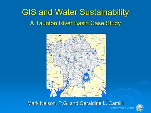
<strong>GIS</strong> <strong>and</strong> <strong>Water</strong> <strong>Sustainability</strong><br />
A Taunton River Basin Case Study<br />
Mark Nelson, P.G. <strong>and</strong> Geraldine L. Camilli<br />
Horsley Witten Group
<strong>Water</strong> <strong>Sustainability</strong> A Growing<br />
Concern<br />
‣ <strong>Water</strong> Not Always Available<br />
Where it is Needed<br />
‣ Interbasin Transfers More<br />
Common – Not Always<br />
Realized<br />
‣ Climate Change Will Only<br />
Exacerbate These Issues<br />
Horsley Witten Group
Underst<strong>and</strong>ing the Hydrologic<br />
Balance of a <strong>Water</strong>shed is Key to<br />
Climate Change Adaptation<br />
• Needed to Underst<strong>and</strong> <strong>Water</strong><br />
Withdrawal <strong>and</strong> Wastewater<br />
Disposal Impacts<br />
• Important for Wetl<strong>and</strong> <strong>Protection</strong><br />
• Important for Stream Baseflow<br />
Management<br />
Horsley Witten Group
Baseflow Alterations<br />
Horsley Witten Group
The Taunton River <strong>Water</strong>shed<br />
‣ Taunton River<br />
• Longest New Engl<strong>and</strong> coastal river unimpaired by dams<br />
• Flat river system: 20 ft elevation over 40 miles<br />
‣ 562 mile 2 watershed<br />
‣ 108 sub-watersheds<br />
‣ Relatively healthy<br />
‣ Diverse habitat<br />
‣ Low permeability soils<br />
‣ Large wetl<strong>and</strong> systems<br />
Horsley Witten Group
Development <strong>and</strong> Stress<br />
‣ Developed l<strong>and</strong> increased over 60% in 30 yrs<br />
‣ <strong>Water</strong> quality impairments<br />
• Algal blooms<br />
• Sediments/siltation<br />
• Pathogens<br />
‣ 43 municipalities<br />
‣ Many with comprehensive<br />
water/wastewater planning<br />
BUT<br />
Need for regional solution<br />
Horsley Witten Group
A <strong>Water</strong>shed-Wide Model<br />
‣ Methodology<br />
‣ Assumptions<br />
‣ Inputs<br />
‣ Data needs<br />
‣ Platform<br />
‣ Results<br />
Horsley Witten Group
Key Model Assumption<br />
‣ “Stream base flow during periods of average<br />
groundwater storage can be used to estimate<br />
recharge” (Hansen & Lapham, 1992)<br />
‣ <strong>Groundwater</strong> recharge = primary source of<br />
base flow to streams<br />
‣ Declines in recharge =<br />
• Reduced base flow<br />
• Potential ecological<br />
Impacts including<br />
habitat loss<br />
Horsley Witten Group
Model Inputs<br />
‣ BF = average annual base flow<br />
‣ GW nat = natural groundwater (gw) recharge<br />
‣ WW GDP = <strong>Groundwater</strong> Discharge Permit inflows<br />
‣ WW septic = private septic system inflows<br />
‣ WS WMA = WMA permitted withdrawals<br />
‣ WS prvt = private gw withdrawals<br />
‣ SW EIA = stormwater runoff from effective<br />
impervious areas<br />
Horsley Witten Group
Model Inputs<br />
Technically Speaking…..<br />
Goesinta = Goesouta<br />
Horsley Witten Group
Stream Base Flow<br />
‣ USGS stream gage data<br />
‣ If record too short to estimate base flow,<br />
determine closest index stream based on:<br />
• Drainage area<br />
• Mean basin slope<br />
• Stratified drift per stream length<br />
‣ Calculate average mean<br />
of minimum monthly flows<br />
for reference stream<br />
‣ Extrapolate base flow for stream of interest<br />
Horsley Witten Group
Natural Recharge<br />
Is a Function of Precipitation<br />
<strong>and</strong><br />
Geology<br />
<strong>and</strong><br />
Hydrology<br />
Horsley Witten Group
<strong>Water</strong> Withdrawal Data<br />
‣ Public groundwater<br />
wells<br />
‣ Surface water<br />
withdrawals<br />
(intake location)<br />
‣ Private groundwater<br />
withdrawals<br />
Horsley Witten Group
Private <strong>Groundwater</strong> Withdrawals<br />
‣ <strong>Water</strong> service areas<br />
‣ L<strong>and</strong> use data<br />
• Residential<br />
• Commercial<br />
• Industrial<br />
• Agricultural<br />
‣ Additional data<br />
• Density<br />
• Per capita water use<br />
Horsley Witten Group
Wastewater Recharge<br />
‣Mass. <strong>Groundwater</strong><br />
Discharge Permits<br />
‣NPDES Permits<br />
‣Private Septic<br />
Systems<br />
Horsley Witten Group
Stormwater Runoff from<br />
Effective Impervious Area (EIA)<br />
Impervious Layer<br />
+<br />
Geology Layer<br />
‣ Total Impervious Area<br />
• Rooftops<br />
• Roads<br />
• Parking lots<br />
• Other (sidewalks, patios)<br />
‣ EIA accounts for small,<br />
disconnected areas<br />
draining to infiltrating<br />
surfaces<br />
Horsley Witten Group
Validating Key Assumptions<br />
Rattlesnake <strong>Water</strong>shed<br />
Horsley Witten Group
Modeling Platform<br />
‣ For Taunton watershed, or single sub-watershed:<br />
• <strong>GIS</strong> geo-processing <strong>and</strong><br />
• Spreadsheet calculations to combine assumptions with<br />
<strong>GIS</strong> results<br />
‣ For 108 sub-watersheds?<br />
‣ For running future scenarios?<br />
• Sewering?<br />
• L<strong>and</strong> use policies / regulations?<br />
• Population growth?<br />
‣ Need automated process<br />
Horsley Witten Group
Model – Geo-processing Engine<br />
‣ Build automated geo-processing model using<br />
embedded Model Builder<br />
Horsley Witten Group
Model – <strong>Water</strong> Budget Engine<br />
‣ Build a “calculator” to read data from <strong>GIS</strong> layers<br />
<strong>and</strong> calculate water budget automatically for<br />
each of 108 sub-watersheds<br />
Horsley Witten Group
Model Verification<br />
‣ Confirm results for two watersheds:<br />
• Rattlesnake Brook<br />
• Coweesset<br />
Rattlesnake<br />
<strong>Water</strong>shed<br />
Coweesset<br />
<strong>Water</strong>shed<br />
Horsley Witten Group
Results - Current <strong>Water</strong> Balance<br />
Entire<br />
<strong>Water</strong>shed<br />
Horsley Witten Group
Results - Current <strong>Water</strong> Balance<br />
Hockomock<br />
Swamp<br />
Subwatershed<br />
Horsley Witten Group
Individual Recharge Terms<br />
‣ Taunton watershed results<br />
• Excluding surface water withdrawals or discharge (left)<br />
• Including surface water withdrawals or discharge (right)<br />
Horsley Witten Group
Use for Broader Audience<br />
Questions<br />
‣Use of <strong>GIS</strong> as a modeling platform?<br />
‣Availability of <strong>GIS</strong> Data?<br />
‣Technical proficiency of potential<br />
users?<br />
Horsley Witten Group
Use for Broader Audience<br />
Opportunities<br />
‣ Adaptability to New Inputs<br />
• Future Changes in Precipitation <strong>and</strong><br />
Recharge<br />
• L<strong>and</strong> use changes <strong>and</strong> impervious cover<br />
changes<br />
• <strong>Water</strong> or Sewer System Improvements<br />
Horsley Witten Group