Biodiversity Strategy - Gosford City Council - NSW Government
Biodiversity Strategy - Gosford City Council - NSW Government Biodiversity Strategy - Gosford City Council - NSW Government
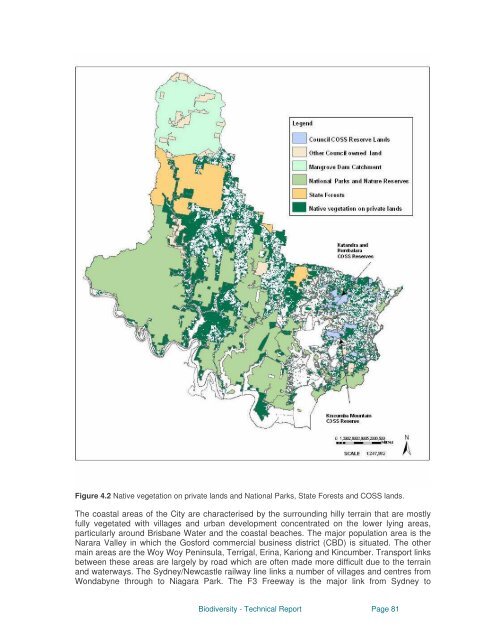
Figure 4.2 Native vegetation on private lands and National Parks, State Forests and COSS lands. The coastal areas of the City are characterised by the surrounding hilly terrain that are mostly fully vegetated with villages and urban development concentrated on the lower lying areas, particularly around Brisbane Water and the coastal beaches. The major population area is the Narara Valley in which the Gosford commercial business district (CBD) is situated. The other main areas are the Woy Woy Peninsula, Terrigal, Erina, Kariong and Kincumber. Transport links between these areas are largely by road which are often made more difficult due to the terrain and waterways. The Sydney/Newcastle railway line links a number of villages and centres from Wondabyne through to Niagara Park. The F3 Freeway is the major link from Sydney to Biodiversity - Technical Report Page 81
Newcastle and forms a major barrier for fauna corridors to the west as well as dividing the coastal parts of the City from the mountain districts. The Central Coast enjoys a rich diversity of native wildlife and terrestrial and aquatic habitats. For example, over 130 threatened plants and animals are found in the local government area. The high number of threatened taxa reflects the area’s diverse natural habitats. Like other coastal areas within close proximity to major cities, the region faces strong development pressures with a resulting decline in biodiversity. Urban areas can support native biodiversity and at the same time have enhanced quality of life for residents and visitors. Despite the relatively large reserve areas and Council’s Coastal Open Space System many natural areas are not protected. Options need to be explored to conserve important bushland remnants and biological diversity across a range of land tenures including private land ownership. These are real and pressing reasons to engage the community in adopting behaviours that help protect biodiversity and maintain the qualities of living on the Central Coast. Strategies aimed at reducing pressure on endangered/threatened species through the rehabilitation of selected corridors to join up remnants (as a part of a biodiversity plan), will benefit the Gosford local government area environmentally and aesthetically. The long term result could provide a huge potential for the city in terms of ecotourism and increased land values. A - 4.2 Geology Gosford City’s geology formed nearly 300 million years ago in the geological period known as the Permian period. At that time, Sydney lay at the mouth of a broad swampy river basin covered in lush plant life ferns, ginkos, primitive conifers, seed ferns, horsetails and trees of Glossopteris. Around 230 million years ago at the beginning of the Triassic period, rivers eroded the inland mountains and began depositing enormous quantities of sand, silt and clay to coast. The sediment layers buried the Permian swamps (these turned into organic coal layers around Sydney and Newcastle) and the sediment layers were compacted into coarse sandstone (Hawkesbury sandstone). The lower layers of finer silts and clays formed mudstone and shale to became the Narrabeen group of sandstone and shales. The sandy middle beds became Hawkesbury sandstones and the uppermost and youngest strata of compressed silt and clay became Wianamatta shales. By the end of the Triassic period, 190 million years ago, sediment accumulations almost stopped. However, Australia was still part of Gondwana supercontinent and pressures began to split the continent. In the Sydney Basin the initial movements were marked by explosive eruptions of small volcanic breccia pipes of diatremes through sedimentary rock (such as at Dillons Farm in Brisbane Water NP). As the continents slowly separated over the next 140 million years there was a movement upwards which formed the Blue Mountains, and a lowering along the faultline of what is now the Hawkesbury Nepean River resulting in the Cumberland plain. Over 50 million years of the Tertiary period rivers cut deep gorges through sandstone. Uplift occurred and gave rise to outcrops of Hawkesbury sandstone. In the last 1.8 million years Quartenary alluvium continued to accumulate. During the Pleistocene ice age the sea level was 100 metres lower than it currently is. Consequently, the mouth of the Hawkesbury River was further east of its present location. There was subsequent melting of the ice caps and the associated sea level rise led to the Hawkesbury River 'drowning'itself resulting in Broken Bay and Brisbane Water. The coastal lagoons were also formed at this time. Minor adjustments have occurred since with perched dunes formed as a result of wind blown sand, an example of this is the sand on the tops of coastal cliffs in Bouddi National Park (Fisher 1997). Biodiversity - Technical Report Page 82
- Page 33 and 34: CONTENTS APPENDIX GOSFORD CITY COUN
- Page 35 and 36: A - 7.7 Human Interactions with Nat
- Page 37 and 38: Genetic diversity is the variety of
- Page 39 and 40: Biodiversity - Technical Report Pag
- Page 41 and 42: A - 2.0 LEGISLATIVE CONTEXT The dev
- Page 43 and 44: Amendment Act 2004 Standard Instrum
- Page 45 and 46: areas within the Greater Metropolit
- Page 47 and 48: A - 2.3.2 Council Corporate Reporti
- Page 49 and 50: Biodiversity Toolbox The Commonweal
- Page 51 and 52: A - 2.4 Discussion of Comparable Pl
- Page 53 and 54: Biodiversity - Technical Report Pag
- Page 55 and 56: A - 2.6 References Australian Local
- Page 57 and 58: • Bushcare Program - ongoing •
- Page 59 and 60: A - 3.2 Appraisal of biodiversity p
- Page 61 and 62: Officer Table 3.2. Area of properti
- Page 63 and 64: and sub-communities and to provide
- Page 65 and 66: the Central Coast. The returned sur
- Page 67 and 68: Council received funding for develo
- Page 69 and 70: Council commissioned the Bush Stone
- Page 71 and 72: education and training opportunitie
- Page 73 and 74: of urban development applications w
- Page 75 and 76: Unmanaged cattle grazing can impact
- Page 77 and 78: Three public schools in the catchme
- Page 79 and 80: Milestone 5 - Monitoring and Report
- Page 81 and 82: A - 3.4 References Australian Museu
- Page 83: (see Figure 4. 3) which accounts fo
- Page 87 and 88: Mooney Mooney and Mangrove Creeks.
- Page 89 and 90: Aeolian Landscapes Beach Landscapes
- Page 91 and 92: A - 4.5 Climate Generally the clima
- Page 93 and 94: Kangaroo, possums, flying squirrels
- Page 95 and 96: A - 4.9 Current Landuse Since the 1
- Page 97 and 98: State government is also preparing
- Page 99 and 100: A - 5.0 TERRESTRIAL BIODIVERSITY Th
- Page 101 and 102: Lily) was once relatively widesprea
- Page 103 and 104: Figure 5.1 Native vegetation commun
- Page 105 and 106: Biodiversity - Technical Report Pag
- Page 107 and 108: There have been few quantitative st
- Page 109 and 110: • Rainforest • Wetlands • Dun
- Page 111 and 112: Figure 5.5 Endangered ecological co
- Page 113 and 114: of streams for water quality purpos
- Page 115 and 116: Figures 5.5 - 5.7 Waratah (Telopea
- Page 117 and 118: A - 5.4 A - 5.4.1 Terrestrial Fauna
- Page 119 and 120: A - 5.4.3 Invertebrates There conti
- Page 121 and 122: A draft Recovery Plan has been prep
- Page 123 and 124: assumption that occupancy of a site
- Page 125 and 126: Variables such as ‘proportion of
- Page 127 and 128: Mount Kincumba to Bouddi NP and Cop
- Page 129 and 130: A - 5.7 References Anon (1996) 'Sev
- Page 131 and 132: Scotts D (1991) “Old-growth fores
- Page 133 and 134: A - 6.2 Aquatic Habitats A - 6.2.1
Figure 4.2 Native vegetation on private lands and National Parks, State Forests and COSS lands.<br />
The coastal areas of the <strong>City</strong> are characterised by the surrounding hilly terrain that are mostly<br />
fully vegetated with villages and urban development concentrated on the lower lying areas,<br />
particularly around Brisbane Water and the coastal beaches. The major population area is the<br />
Narara Valley in which the <strong>Gosford</strong> commercial business district (CBD) is situated. The other<br />
main areas are the Woy Woy Peninsula, Terrigal, Erina, Kariong and Kincumber. Transport links<br />
between these areas are largely by road which are often made more difficult due to the terrain<br />
and waterways. The Sydney/Newcastle railway line links a number of villages and centres from<br />
Wondabyne through to Niagara Park. The F3 Freeway is the major link from Sydney to<br />
<strong>Biodiversity</strong> - Technical Report Page 81


