an engineering geological characterisation of tropical clays - GBV
an engineering geological characterisation of tropical clays - GBV
an engineering geological characterisation of tropical clays - GBV

Create successful ePaper yourself
Turn your PDF publications into a flip-book with our unique Google optimized e-Paper software.
9<br />
slopes. The northern boundary between the two physiographic units <strong>of</strong> the Kikuyu highl<strong>an</strong>ds <strong>an</strong>d<br />
the plains is roughly along the east - west line across the Nairobi city centre (Sikes, 1926). The<br />
plains are made up <strong>of</strong> two parts, i.e. the Athi plains <strong>an</strong>d the northern section <strong>of</strong> the Kapiti plains,<br />
both <strong>of</strong> which extend further southwards <strong>an</strong>d eastwards, respectively, beyond the study area. These<br />
plains are underlain by a succession <strong>of</strong> lava flows which usually alternate <strong>an</strong>d/ or intermingle with<br />
lake beds, stream deposits, tuffs <strong>an</strong>d volc<strong>an</strong>ic ash (Saggerson, 1991).<br />
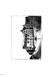
Plate 1.8 (a) Flat plains around Embakasi station. Plate 1.8 (b) Flat plains around J.K.I.A. Airport.<br />
The Athi plains rise from <strong>an</strong> altitude <strong>of</strong> about 1500 m at Athi River, located about 8 km south-east<br />
<strong>of</strong> the present area; to about 1800 m above sea level farther west in the faulted region near Ngong.<br />
The plains form gently rolling grassl<strong>an</strong>ds with a fairly even surface. They end in <strong>an</strong> abrupt<br />
escarpment just west <strong>of</strong> the Athi river. The abrupt escarpment represents the end <strong>of</strong> a lava flow. In<br />
addition, some smaller <strong>an</strong>d low east-facing scarps also occur within, <strong>an</strong>d represent the margins <strong>of</strong><br />
partly eroded lava flows (Gregory, 1921; Saggerson, 1991). The plains are being dissected by<br />
down-cutting rivers (over 30 m below the general l<strong>an</strong>d surface in some places) currently flowing<br />
into the main Athi river. Some steep-sided valleys are also found in the form <strong>of</strong> gullies <strong>an</strong>d c<strong>an</strong>yonlike<br />
gorges cutting into lavas such as along the Nairobi, Mathare <strong>an</strong>d Gitathuru river valleys in the<br />
northern part, as well as the tributaries <strong>of</strong> the Athi river which include Mokoyeti, Sosi<strong>an</strong> <strong>an</strong>d<br />
Mbagathi river valleys in the southern part <strong>of</strong> the study area, respectively. On the other h<strong>an</strong>d, areas<br />
with s<strong>of</strong>t material are characterised by relatively wide valleys, <strong>an</strong>d this is noticeable in lower<br />
sections <strong>of</strong> the Nairobi river valley, as well as along other stream courses in the southern <strong>an</strong>d southwestern<br />
parts <strong>of</strong> the study area. The plains are mainly underlain by phonolitic volc<strong>an</strong>ic rocks <strong>an</strong>d<br />
tuff (Saggerson, 1991).<br />
The Kapiti plains occur to the east <strong>of</strong> the Athi river, where the topography is more variable, from<br />
gently undulating to flat with a number <strong>of</strong> small hills protruding above the general l<strong>an</strong>d surface.<br />
One large hill mass, the Lukenya, is found located in a metamorphic region <strong>of</strong> the plains to the east<br />
<strong>of</strong> the present area. Underlying the plains are volc<strong>an</strong>ic rocks, tuff <strong>an</strong>d metamorphic rocks. The<br />
plains are located in a drier region having no perm<strong>an</strong>ent rivers; <strong>an</strong>d the seasonal stream-beds found<br />
contain water for only short periods <strong>of</strong> time in a year. The dissection <strong>of</strong> these plains is therefore<br />
relatively less severe. Gully erosion is, however, common <strong>an</strong>d characteristic.<br />
The Athi <strong>an</strong>d Kapiti plains extend farther south-eastwards <strong>an</strong>d eastwards beyond the present study<br />
area, where they are bounded by the central hill masses <strong>of</strong> Machakos District (Machakos hills).<br />
These consist <strong>of</strong> the Ith<strong>an</strong>ga, Mua <strong>an</strong>d Iveti hills as well as the K<strong>an</strong>zalu r<strong>an</strong>ge <strong>an</strong>d Donyo Sabuk.<br />
The hills rise abruptly above the surrounding plains. They are also steep-sided <strong>an</strong>d being actively<br />
dissected, partly as a result <strong>of</strong> existing poor l<strong>an</strong>d m<strong>an</strong>agement.<br />
There is also a general rise in relief from the south-east towards the north-west, across the study<br />
area. Elevations <strong>of</strong> 1540 - 1600 m above sea level occur in the south-eastern parts; 1620 - 1680 m