Howland MS STP - Ohio Department of Transportation
Howland MS STP - Ohio Department of Transportation
Howland MS STP - Ohio Department of Transportation

You also want an ePaper? Increase the reach of your titles
YUMPU automatically turns print PDFs into web optimized ePapers that Google loves.
<strong>Howland</strong> Local Schools<br />
<strong>Howland</strong> Middle School<br />
SAFE ROUTES TO SCHOOL TRAVEL PLAN<br />
January 2013
TABLE OF CONTENTS<br />
Introduction ..................................................................................................................................... 1<br />
Our School ....................................................................................................................................................... 1<br />
Our SRTS Vision ............................................................................................................................................... 2<br />
Current Student Travel ................................................................................................................................... 3<br />
Students Living Within Walking and Bicycling Distance <strong>of</strong> School .................................................... 3<br />
Amount and Route <strong>of</strong> Students Currently Walking and Bicycling to School ..................................... 3<br />
School or District Policies that Impact Students Walking and Bicycling to School ........................... 4<br />
School Arrival and Dismissal Process ................................................................................................ 4<br />
Parent Attitudes Towards Walking and Biking .................................................................................. 4<br />
Safety Issues and Concerns ............................................................................................................... 5<br />
Relevant Traffic Crashes .................................................................................................................... 5<br />
| <strong>Ohio</strong>’s Safe Routes to School Travel Plan Template | www.dot.state.oh.us/saferoutes<br />
Walking and Bicycling Encouragement Activities at the School ....................................................... 5<br />
Key Issues Impacting Safe Walking and Bicycling to School .......................................................................... 6<br />
Recommended SRTS Countermeasures .................................................................................................. 6<br />
Non Infrastructure Countermeasures ............................................................................................... 6<br />
12 Month Activity Calendar .............................................................................................................. 9<br />
Infrastructure Countermeasures .................................................................................................... 10<br />
Public Input ................................................................................................................................................... 12<br />
Final Plan – Pledge <strong>of</strong> Support ..................................................................................................................... 13<br />
Appendix A – ODOT Student Radius Map<br />
Appendix B – Student Travel Tally and Parent Survey<br />
Appendix C – <strong>Howland</strong> Middle School Bus Policy<br />
Appendix D – Countermeasure Maps<br />
Appendix E – Public Input Information
INTRODUCTION<br />
Safe Routes to School Program<br />
The Safe Routes to School (SRTS) program is a federally funded, community‐based initiative to create safe,<br />
convenient, and fun opportunities for children to bicycle and walk to and from schools. The program has<br />
been designed to reverse the decline in children walking and bicycling to schools, and to help address the<br />
alarming nationwide trend toward childhood obesity and inactivity.<br />
A SRTS Team representing diverse sectors <strong>of</strong> <strong>Howland</strong> Township was convened in September <strong>of</strong> 2012, and<br />
has met regularly since that time to develop and implement a SRTS Improvement Plan for <strong>Howland</strong><br />
Middle School.<br />
Using the five “E’s”: Engineering, Education, Enforcement, Encouragement and Evaluation, the task force<br />
identified how current conditions could be improved to make it safer and more attractive for children to<br />
walk and bicycle to school. Engineering refers to infrastructure projects that improve the pedestrian and<br />
bicycle environment within two miles <strong>of</strong> a school. The other E’s refer to non‐infrastructure programs that<br />
are intended to affect student or driver behavior to result in more walking and biking to school.<br />
| <strong>Ohio</strong>’s Safe Routes to School Travel Plan Template | www.dot.state.oh.us/saferoutes<br />
1<br />
School District School Name School Address Grades served<br />
<strong>Howland</strong> Local Schools <strong>Howland</strong> Middle School 8100 South St SE, Warren,<br />
OH 44484‐2445<br />
Average<br />
Daily<br />
Student<br />
Enrollment<br />
OUR SCHOOL<br />
Black,<br />
non‐<br />
Hispanic<br />
American<br />
Indian or<br />
Alaska<br />
Native<br />
Asian<br />
or<br />
Pacific<br />
Islander<br />
Your School’s Students 2011‐2012<br />
Hispanic<br />
Multi‐<br />
Racial<br />
White,<br />
non‐<br />
Hispanic<br />
Economically<br />
Disadvantaged<br />
Limited<br />
English<br />
Pr<strong>of</strong>icient<br />
Students<br />
with<br />
Disabilities<br />
715 6.9% ‐ ‐ ‐ 4% 87.1% 37.5% ‐ 11.7% ‐<br />
Community Stakeholders and the Safe Routes to School Team:<br />
School Representatives:<br />
Name Email address 5 E Role:<br />
Kevin Spicher, Principal,<br />
<strong>Howland</strong> Middle School<br />
Kevin.spicher@neomin.org<br />
Education<br />
Encouragement<br />
Evaluation<br />
Jeff McVicker,<br />
<strong>Transportation</strong> Director<br />
<strong>Howland</strong> Local School District<br />
John Sheets, Superintendent<br />
<strong>Howland</strong> Local School District<br />
Jeff.mcvicker@neomin.org<br />
John.sheets@neomin.org<br />
Engineering<br />
Evaluation<br />
Encouragement<br />
Evaluation<br />
Community Representatives:<br />
Name Email address 5 E Role:<br />
Jilene & Jeff Beadle Jbeadle001@neo.rr.com Encouragement<br />
Leslie Gumino lagumino@neo.rr.com Encouragement<br />
6‐8<br />
Migrant
| <strong>Ohio</strong>’s Safe Routes to School Travel Plan Template | www.dot.state.oh.us/saferoutes<br />
Local Government Representatives:<br />
Name Email address 5 E Role:<br />
Kim Mascarella, Director <strong>of</strong><br />
Planning and Zoning<br />
<strong>Howland</strong> Township<br />
Kim.mascarella@howlandtownship.org Encouragement<br />
Engineering<br />
Evaluation<br />
Darlene St. George<br />
Administrator<br />
<strong>Howland</strong> Township<br />
Matthew Vansuch, Trustee<br />
<strong>Howland</strong> Township<br />
Darlene.stgeorge@howlandtownhip.org<br />
Matthew.vansuch@howlandtownship.org<br />
Encouragement<br />
Engineering<br />
Evaluation<br />
Encouragement<br />
Engineering<br />
Evaluation<br />
Education Representative:<br />
Name Email address 5 E Role:<br />
Annmarie Thigpen Annmarie.thigpen@neomin.org Education<br />
Encouragement<br />
Evaluation<br />
Barbara Wright,<br />
School Board Member<br />
<strong>Howland</strong> Local Schools<br />
BL56wright@aol.com<br />
Education<br />
Evaluation<br />
Health Representatives:<br />
Name Email address 5 E Role:<br />
Mel Milliron, CHES<br />
Health Educator<br />
Trumbull County Health Dept.<br />
hemillir@co.trumbull.oh.us<br />
Education<br />
Encouragement<br />
Public Safety Representatives:<br />
Name Email address 5 E Role:<br />
Paul Monroe, Police Chief<br />
<strong>Howland</strong> Township<br />
Paul.monroe@howlandtownship.org Enforcement<br />
Evaluation<br />
The Lead Contact For Our Plan is:<br />
Name: Kimberly Mascarella<br />
Affiliation: <strong>Howland</strong> Township, Director <strong>of</strong> Planning & Zoning<br />
Phone Number: 330‐856‐3461<br />
Email address: kim.mascarella@howlandtownship.org<br />
Mailing address: 205 Niles‐Cortland Road NE, Warren, OH 44484<br />
SECTION 2: OUR SRTS VISION<br />
<strong>Howland</strong> Township and <strong>Howland</strong> Middle School aspire to create a safe and inviting environment that<br />
supports a healthy lifestyle <strong>of</strong> every child, every day.<br />
Our anticipated outcomes are to reduce traffic congestion around the school in order to minimize<br />
student‐vehicle conflicts and improve air quality; and to maximize the number <strong>of</strong> walkers and bicyclists by<br />
making routes to school safer and more inviting, resulting in students’ improved physical health.<br />
2
SECTION 3: CURRENT STUDENT TRAVEL<br />
| <strong>Ohio</strong>’s Safe Routes to School Travel Plan Template | www.dot.state.oh.us/saferoutes<br />
This chapter describes information obtained from <strong>Howland</strong> Middle School regarding the potential amount<br />
<strong>of</strong> students to walk or bicycle to school; the amount and routes <strong>of</strong> students that currently walk or bicycle<br />
to school; and the issues preventing students from walking or bicycling to school.<br />
<strong>Howland</strong> Local School District<br />
<strong>Howland</strong> Township is located in northeast <strong>Ohio</strong>, east <strong>of</strong> Warren. The <strong>Howland</strong> Local School District<br />
encompasses the entire community <strong>of</strong> <strong>Howland</strong> Township. As <strong>of</strong> the 2012‐2013 school year, the district<br />
includes six schools. This report focuses on <strong>Howland</strong> Middle School.<br />
Students Living Within Walking and Bicycling Distance <strong>of</strong> School<br />
The Safe Routes to School program defines a reasonable distance to walk to school as one (1) mile and<br />
bicycle to school as two (2) miles or closer. To better determine the potential amount <strong>of</strong> students walking<br />
and bicycling to school, the table below lists the amount <strong>of</strong> students living within specified distances from<br />
the school. This information is approximated from the Safe Routes to School Radius Map, provided by the<br />
<strong>Ohio</strong> <strong>Department</strong> <strong>of</strong> <strong>Transportation</strong>. The School Radius Maps for <strong>Howland</strong> Middle School is located in<br />
Appendix A.<br />
Distance From School Number <strong>of</strong> Students % <strong>of</strong> Student Body<br />
Within 1/4 mile <strong>of</strong> school 7 1%<br />
Within 1/2 mile <strong>of</strong> school 40 6%<br />
Within 1 mile <strong>of</strong> school 102 15%<br />
Within 2 miles <strong>of</strong> school 438 62%<br />
Amount and Routes <strong>of</strong> Students that Currently Walk or Bicycle to School<br />
The student travel tally report and discussions with school <strong>of</strong>ficials were used to determine travel modes<br />
and primary walking and bicycling routes to and from school. This information is summarized in the table<br />
below. A summary <strong>of</strong> the Student Travel Tally can be found in Appendix B.<br />
Number <strong>of</strong><br />
students<br />
(morning trips)<br />
Number <strong>of</strong><br />
students<br />
(afternoon trips)<br />
Primary<br />
walking/bicycling<br />
routes<br />
Walk<br />
Bike<br />
School<br />
bus<br />
Family<br />
Vehicle<br />
Carpool<br />
Public<br />
Transit<br />
Other<br />
2% 0% 81% 16% 0.6% 0.2% 0.1%<br />
4% 0% 73% 21% 2% 0.2% 0.3%<br />
Brewster Drive – campus to East Market Street<br />
South Street‐ Willow Street to Niles Cortland Road (S.R. 46)<br />
Willow Street – South Street to Kettering Street<br />
Kettering Street ‐ Willow Street to Niles Cortland Road (S.R. 46)<br />
3
| <strong>Ohio</strong>’s Safe Routes to School Travel Plan Template | www.dot.state.oh.us/saferoutes<br />
District Policies that Impact Students Walking or Bicycling to School<br />
The district provides transportation to all students, with the exception <strong>of</strong> those that live in the Laurelwood<br />
or Clifton neighborhoods. However, students are permitted to walk or bicycle to school with parental<br />
permission. The <strong>of</strong>ficial <strong>Transportation</strong> Policy is located in Appendix C.<br />
School Arrival and Dismissal Process<br />
Do school buses and parent vehicles use the same driveway for arrival and dismissal?<br />
Yes, all vehicles use the same driveway.<br />
No, there are separate driveways for family vehicles and school buses.<br />
Buses use the rear parking lot, and family vehicles use the circular drive in the front <strong>of</strong> the building.<br />
Do all students use the same entrance to the school building in the morning?<br />
Yes, all students enter the building at the same location.<br />
No, students can use different entrances.<br />
Students arriving by bus use the two entrances in the rear <strong>of</strong> the school. These entrances are<br />
separated by grade. Students arriving by family vehicle, bicycle or walking use the entrance in the<br />
front <strong>of</strong> the school.<br />
Are all students released at the same time during dismissal?<br />
Yes, all students are released at the same time.<br />
No, we use a staggered release process (walkers are released first, bus riders second, etc.).<br />
Is school staff involved in either arrival or dismissal?<br />
Yes, we have school staff help students enter and exit the campus safely.<br />
No, school staff is not involved in either arrival or dismissal.<br />
School staff members monitor students entering and exiting the building.<br />
Are there any adult crossing guards located along student walking routes?<br />
Yes, we have at least one adult crossing guard that helps students on their walking routes.<br />
No, we do not have any adult crossing guards serving our school.<br />
Are there police <strong>of</strong>ficers that help with arrival or dismissal procedures at this school?<br />
Yes, we have at least one police <strong>of</strong>ficer helping direct traffic around our school.<br />
No we do not have police <strong>of</strong>ficers who help direct traffic around the school.<br />
An <strong>of</strong>ficer assists in helping busses onto State Route 46 (Niles Cortland Road).<br />
Are students involved in any arrival or dismissal process (i.e. student safety patrol)?<br />
Yes, we have a student safety patrol.<br />
No, we do not have a student safety patrol.<br />
Parent Attitudes Towards Walking and Biking<br />
The Safe Routes to School Standard Parent Survey was conducted in September 2012. This survey<br />
provided valuable insight on parent attitudes toward students walking or bicycling to school. The top five<br />
(5) reasons, cited on the survey, that parents do not allow their children to walk or bicycle to school are<br />
listed in the table below.<br />
Reasons for not allowing children to walk or bicycle to school:<br />
Speed <strong>of</strong> traffic along route – 84%<br />
Amount <strong>of</strong> traffic along route – 83%<br />
Safety <strong>of</strong> intersections and crossings – 83%<br />
Distance – 79%<br />
Weather or climate – 68%<br />
4
Safety Issues and Concerns<br />
The following is a list <strong>of</strong> traffic safety issues and concerns that were gathered anecdotally from the team,<br />
parents and the community at large:<br />
| <strong>Ohio</strong>’s Safe Routes to School Travel Plan Template | www.dot.state.oh.us/saferoutes<br />
<br />
<br />
<br />
<br />
<br />
<br />
There is not a dedicated location that is large enough to accommodate the volume <strong>of</strong><br />
parent vehicles at dismissal. Currently parents are parking along Brewster Street and<br />
illegally at local businesses.<br />
Students ambiguously cross Brewster Street to get to illegally parked family vehicles.<br />
There is not sufficient width for busses to travel along Brewster Street when family<br />
vehicles are parked along the roadway. Busses are currently running over the sidewalk<br />
inside the curve across from the parent loop and damaging the sidewalk.<br />
State Route 46 has a high traffic volume near South Street. This is a safety concern for<br />
busses that turn left and students that wish to cross this route.<br />
The configuration <strong>of</strong> the signalized intersection <strong>of</strong> East Market Street and Brewster Street<br />
creates a safety issue for vehicles and pedestrians. The existing signal heads are located<br />
on the near side <strong>of</strong> the intersection. As a result, it is difficult for drivers to see the signal<br />
head and pedestrians at the same time. Also, the pedestrian signals are broken, outdated,<br />
and not MUTCD compliant. A student has been hit at this intersection.<br />
There is no sidewalk connecting the school and the neighborhood to the east.<br />
Relevant Traffic Crashes<br />
Crash data reports were recorded for routes within two (2) miles <strong>of</strong> the school, and over the most recent<br />
three (3) years for which data was available. The results are summarized below:<br />
There were 10 total crashes within the <strong>STP</strong> study area.<br />
The crashes resulted in 7 injuries and 2 fatalities.<br />
The number <strong>of</strong> crashes that involved bicycles was 5.<br />
The number <strong>of</strong> crashes that involved pedestrians was 5<br />
Walking and bicycling encouragement activities at the school<br />
Activity<br />
Curriculum<br />
Walk for Technology and Race<br />
for the Cure<br />
How it encourages walking or bicycling<br />
Students learn about the benefits <strong>of</strong> physical activity,<br />
including walking and bicycling to school, in health and<br />
physical education classes.<br />
By participating in these community events, students become<br />
more excited about walking.<br />
5
SECTION 4: KEY ISSUES IMPACTING SAFE WALKING AND<br />
BICYCLING TO SCHOOL<br />
Issue/Description<br />
| <strong>Ohio</strong>’s Safe Routes to School Travel Plan Template | www.dot.state.oh.us/saferoutes<br />
6<br />
Mix <strong>of</strong> Traffic and Pedestrians on Brewster Street:<br />
The mix <strong>of</strong> family vehicle, bus and pedestrian traffic along Brewster Street creates a<br />
safety concern.<br />
Brewster Street does not have sufficient width to handle both family vehicles and<br />
busses.<br />
Students ambiguously cross Brewster Street to get to illegally parked family vehicles.<br />
Speed/Amount <strong>of</strong> Traffic:<br />
There is a high volume <strong>of</strong> traffic along Market Street, and S.R. 46. It is very difficult for<br />
students to cross these roadways<br />
Signal at the intersection <strong>of</strong> East Market Street and Brewster Street:<br />
It is difficult to see signal heads and pedestrians at the same time due to the position <strong>of</strong><br />
signal heads.<br />
Pedestrian signals are not fully operational and outdated at this traffic signal.<br />
Intersections:<br />
Intersections near the school are not clearly signed, creating confusion for drivers and<br />
pedestrians.<br />
Crossings are not marked or ADA compliant<br />
Sidewalks:<br />
Sidewalks near the school are damaged. Students were observed tripping over portions<br />
<strong>of</strong> damaged sidewalk<br />
Many roadways surrounding the school do not have sidewalks.<br />
There is no sidewalk connecting the school and the neighborhood to the east.<br />
SECTION 5: RECOMMENDED SRTS COUNTERMEASURES<br />
This chapter discusses issues that impact walking and bicycling to <strong>Howland</strong> Middle School, and proposes<br />
countermeasures to addressing them.<br />
The issues covered in this chapter were identified through discussions with the SRTS Team; responses to<br />
principal and parent surveys; walk audits at each school; evaluation <strong>of</strong> written documents detailing city<br />
and school district plans, policies procedures, and programs; and evaluation <strong>of</strong> data provided by the state,<br />
city, and school district.<br />
Non‐infrastructure Countermeasure Recommendations<br />
In order to emphasize the multifaceted approach necessary to address identified issues, countermeasures<br />
are categorized based on the “5 Es” (education, enforcement, encouragement, engineering, and<br />
evaluation). Non‐infrastructure countermeasures represent four <strong>of</strong> the “5 Es” (education, enforcement,<br />
encouragement, and evaluation). A calendar is provided to show the month anticipated to implement the<br />
non‐infrastructure countermeasures planned for the next 12 months.
The last <strong>of</strong> the “5Es,” Engineering, is represented in the non‐infrastructure tables. These tables provide<br />
information on the approximate cost, priority, and a general timeframe anticipated for implementation.<br />
EDUCATION COUNTERMEASURES:<br />
The table below provides a list <strong>of</strong> the education strategies the team plans to implement in the next 12<br />
months.<br />
Student Health<br />
Issue<br />
General Education<br />
EDUCATION<br />
Countermeasure<br />
Educate students regarding academic and health benefits <strong>of</strong><br />
physical activity<br />
Promote ODOT’s Every Move you Make, Keep It Safe<br />
Campaign<br />
| <strong>Ohio</strong>’s Safe Routes to School Travel Plan Template | www.dot.state.oh.us/saferoutes<br />
The medium and long term (beyond 12 months) education strategies are:<br />
1. Establish a safe route across S.R. 46 utilizing the signalized intersection at East Market Street.<br />
Educate students and parents on how to properly use a pedestrian signal to safely cross the<br />
street, after pedestrian signals are installed.<br />
ENCOURAGEMENT COUNTERMEASURES:<br />
The table below provides a list <strong>of</strong> the encouragement strategies the team plans to implement in the next<br />
12 months.<br />
Issue<br />
General Safety<br />
Student Health<br />
Encouraging use <strong>of</strong> Bicycling<br />
Student Health<br />
ENCOURAGEMENT<br />
Countermeasure<br />
Develop an age appropriate volunteer walking school bus<br />
program<br />
Participate in International Walk to School Day<br />
BMX Rider School Assembly Program<br />
Participate in National Bike to School Day<br />
The medium and long term (beyond 12 months) encouragement strategies are:<br />
1. Establish a frequent walker and bicyclist rewards program.<br />
2. Establish a bicycle club.<br />
3. Evaluate and reconsider the appropriate layout and policies for busses and family vehicles to<br />
alleviate congestion around the school. Reduced congestion will encourage more students<br />
to walk and bicycle by separating them from other vehicles.<br />
ENFORCEMENT COUNTERMEASURES:<br />
The table below provides a list <strong>of</strong> the enforcement strategies the team plans to implement in the next 12<br />
months.<br />
Issue<br />
Safety <strong>of</strong> Intersections and<br />
Crossings<br />
ENFORCEMENT<br />
Countermeasure<br />
Train and provide equipment for volunteer crossing guards<br />
to work at the intersection <strong>of</strong> East Market Street and<br />
Brewster Street<br />
The medium and long term (beyond 12 months) enforcement strategies:<br />
1. Consider providing volunteer crossing guards at the intersection <strong>of</strong> East Market Street and<br />
S.R. 46<br />
2. Establish a targeted enforcement program for vehicles that speed in school zones.<br />
7
EVALUATION COUNTERMEASURES:<br />
The table below provides a list <strong>of</strong> the evaluation strategies the team plans to implement in the next 12<br />
months.<br />
Issue<br />
SRTS Program Sustainability<br />
SRTS Program Sustainability<br />
EVALUATION<br />
Countermeasure<br />
Conduct Student Travel Tally<br />
Conduct Parent Survey<br />
The medium and long term (beyond 12 months) evaluation strategies are:<br />
1. Conduct Student Travel Tallies and Parent Surveys annually.<br />
2. Evaluate and update the SRTS travel plan annually.<br />
3. Re‐evaluate the safest route for students to cross S.R. 46, based on the results <strong>of</strong> the signal<br />
study and the pedestrian improvements to the signalized intersection at East Market Street.<br />
4. Evaluate the need for sidewalks in the neighborhood east <strong>of</strong> S.R. 46, based on the<br />
established safe route.<br />
| <strong>Ohio</strong>’s Safe Routes to School Travel Plan Template | www.dot.state.oh.us/saferoutes<br />
8
Your 12‐Month SRTS Non‐Infrastructure Activity Calendar<br />
This calendar shows the anticipated schedule for the planning and implementation <strong>of</strong> the recommended non‐infrastructure activities in the next<br />
12 months.<br />
Non‐Infrastructure<br />
Countermeasure<br />
Jun Jul Aug Sept Oct Nov Dec Jan Feb Mar Apr May<br />
| <strong>Ohio</strong>’s Safe Routes to School Travel Plan Template | www.dot.state.oh.us/saferoutes<br />
Promote ODOT’s “Every Move You PLAN<br />
Make, Keep It Safe” Campaign<br />
LEAD: Kevin Spicher IMPLEMENT<br />
Develop a Walking School Bus PLAN<br />
Program<br />
LEAD: Kevin Spicher IMPLEMENT<br />
Participate in International Walk to PLAN<br />
School Day<br />
LEAD: Kevin Spicher IMPLEMENT<br />
BMX Rider School Assembly<br />
PLAN<br />
Program<br />
LEAD: Kevin Spicher IMPLEMENT<br />
Participate in National Bike to PLAN<br />
School Day<br />
LEAD: Kevin Spicher IMPLEMENT<br />
Train Crossing Guards PLAN<br />
LEAD: Kevin Spicher IMPLEMENT<br />
Conduct Student Travel Tallies PLAN<br />
LEAD: Kevin Spicher IMPLEMENT<br />
Conduct Parent Surveys PLAN<br />
LEAD: Kevin Spicher IMPLEMENT<br />
9
Infrastructure Countermeasure Recommendations<br />
The team has identified engineering strategies that are appropriate and feasible. The table below summarizes this information and provides a<br />
preliminary cost estimate. Each strategy is classified by timeframe, priority and estimated cost:<br />
| <strong>Ohio</strong>’s Safe Routes to School Travel Plan Template | www.dot.state.oh.us/saferoutes<br />
<br />
<br />
<br />
Timeframes indicate the time it will take to implement the strategy (Short Term: 0‐3 years, Medium Term: 4‐7 years or Long Term: 8+ years).<br />
The priority <strong>of</strong> the project was determined through public input, and classified as High, Medium or Low Priority.<br />
The estimated cost <strong>of</strong> the project include design fees, and is classified as high, medium or low cost (Low Cost: $20,000 or below, Medium<br />
Cost: $20,000 to $150,000 and High Cost: $150,000 or above).<br />
A map <strong>of</strong> the recommended infrastructure countermeasures is provided in Appendix D.<br />
Location Need Countermeasure Timeframe Priority<br />
<strong>Howland</strong> Middle<br />
School Campus<br />
East Market Street<br />
and Brewster Street<br />
Brewster Street ,<br />
Willow Street,<br />
Kettering Street, and<br />
South Street<br />
The intersection <strong>of</strong><br />
Willow Street/South<br />
Street/Brewster<br />
Street<br />
East Market Street at<br />
the intersections <strong>of</strong><br />
Brewster Street,<br />
Willow Drive and at<br />
Niles Cortland Road<br />
(S.R. 46)<br />
There is no place for students<br />
to store bicycles on campus<br />
Drivers need more visible<br />
warning that they are<br />
entering a school zone.<br />
Drivers need additional<br />
warning that they are near a<br />
school zone.<br />
The existing configuration is<br />
confusing to drivers and<br />
pedestrians.<br />
The existing signalized<br />
intersections are not MUTCD<br />
compliant. With the existing<br />
configuration, it is difficult to<br />
see both a pedestrian and<br />
the signal head. Also, the<br />
pedestrian signals are<br />
broken, out <strong>of</strong> date, or not<br />
present.<br />
Install U‐shaped bicycle racks<br />
on the campus.<br />
Install new School Zone<br />
Flashers<br />
Install new SCHOOL<br />
pavement markings and<br />
signage to notify drivers <strong>of</strong><br />
potential school zone activity.<br />
Convert the intersection to a<br />
three way stop. Also, add a<br />
crosswalk across the<br />
Brewster Street Approach.<br />
Reconstruct the existing<br />
signalized intersections to<br />
comply with current ODOT<br />
standards. Add pedestrian<br />
countdown signals, ADA<br />
compliant curb ramps, and<br />
stop lines.<br />
Short Term<br />
Short Term<br />
Short Term<br />
Short Term<br />
Short Term<br />
High<br />
Priority<br />
High<br />
Priority<br />
Medium<br />
Priority<br />
High<br />
Priority<br />
High<br />
Priority<br />
Responsible<br />
Party<br />
<strong>Howland</strong><br />
Township<br />
<strong>Howland</strong><br />
Township<br />
<strong>Howland</strong><br />
Township<br />
<strong>Howland</strong><br />
Township<br />
<strong>Howland</strong><br />
Township<br />
Estimated<br />
Cost<br />
Low<br />
$5,000<br />
Low<br />
$10,000<br />
Low<br />
$4,000<br />
Low<br />
$3,000<br />
High<br />
$450,000<br />
Possible Funding<br />
Source<br />
ODOT SRTS<br />
ODOT SRTS<br />
ODOT SRTS<br />
ODOT Sign Program<br />
ODOT SRTS<br />
ODOT SRTS<br />
Status<br />
10
| <strong>Ohio</strong>’s Safe Routes to School Travel Plan Template | www.dot.state.oh.us/saferoutes<br />
Brewster Street at<br />
the existing parent<br />
loop, approximately<br />
450 feet west <strong>of</strong><br />
Willow Street.<br />
The intersection <strong>of</strong><br />
State Route 46 and<br />
South Street<br />
Laurelwood Drive<br />
from East Market<br />
Street to<br />
Heatherwood Drive<br />
and Heatherwood<br />
Drive from<br />
Laurelwood Drive to<br />
Laurelwood Drive<br />
Laurelwood<br />
Drive/Willow Street<br />
from Heatherwood<br />
Drive to Kettering<br />
Drive on the<br />
north/west side <strong>of</strong><br />
the roadway<br />
Willow Street from<br />
Kettering Street to<br />
South Street on both<br />
sides <strong>of</strong> the roadway<br />
The existing crosswalk and<br />
ramp are not ADA compliant;<br />
busses do not have sufficient<br />
space to make the turn<br />
around the curve in this area;<br />
students were observed<br />
tripping over damaged<br />
sidewalk.<br />
State route 46 is a high<br />
volume roadway. There is a<br />
safety concern for busses<br />
turning left out <strong>of</strong> this<br />
entrance and students that<br />
cross the roadway at this<br />
location.<br />
There is no sidewalk<br />
connecting the adjacent<br />
neighborhood to the school.<br />
There is no sidewalk<br />
connecting the adjacent<br />
neighborhood to the school.<br />
There is no sidewalk<br />
connecting the adjacent<br />
neighborhood to the school.<br />
Install new ADA compliant<br />
curb ramps, crosswalks,<br />
pedestrian signage, and<br />
replace approximately 50<br />
feet <strong>of</strong> damaged sidewalk.<br />
Conduct a signal warrant<br />
analysis at the intersection<br />
for a potential traffic signal or<br />
flashing beacon.<br />
Install approximately 2,500<br />
feet <strong>of</strong> 5 foot wide sidewalk<br />
along the east side <strong>of</strong><br />
Laurelwood Drive and<br />
Heatherwood Drive.<br />
Install approximately 1,700<br />
feet <strong>of</strong> 5 foot wide sidewalk<br />
along the north side <strong>of</strong><br />
Laurelwood Drive and the<br />
west side <strong>of</strong> Willow Street.<br />
Install approximately 2,000<br />
feet <strong>of</strong> 5 foot wide sidewalk<br />
along both sides <strong>of</strong> Willow<br />
Drive.<br />
Medium<br />
Term<br />
Short Term<br />
Medium<br />
Term<br />
Medium<br />
Term<br />
Medium<br />
Term<br />
Medium<br />
Priority<br />
Medium<br />
Priority<br />
<strong>Howland</strong><br />
Township<br />
<strong>Howland</strong><br />
Township<br />
High Priority Medium Priority Low Priority Total<br />
Total Estimated Costs $838,000 $20,000 $0 $858,000<br />
High<br />
Priority<br />
High<br />
Priority<br />
High<br />
Priority<br />
<strong>Howland</strong><br />
Township<br />
<strong>Howland</strong><br />
Township<br />
<strong>Howland</strong><br />
Township<br />
Low<br />
$6,000<br />
Low Cost<br />
$10,000<br />
High Cost<br />
$150,000<br />
High Cost<br />
$100,000<br />
ODOT SRTS<br />
ODOT SRTS<br />
ODOT SRTS<br />
ODOT SRTS<br />
$120,000 ODOT SRTS<br />
11
SECTION 6: PUBLIC INPUT<br />
A summary <strong>of</strong> the public input received for the <strong>Howland</strong> Middle School Travel<br />
Plan can be found in the table below.<br />
| <strong>Ohio</strong>’s Safe Routes to School Travel Plan Template | www.dot.state.oh.us/saferoutes<br />
Public Input Process: Presented at a public meeting held at <strong>Howland</strong> Middle School<br />
Date: December 5, 2012<br />
Target Audience: Parents, teachers, general community, <strong>STP</strong> team members<br />
Key Input Received:<br />
A countermeasure to help alleviate the congestion, illegal parking, and<br />
erroneous crossings <strong>of</strong> Brewster Street was presented at the meeting. This<br />
countermeasure included relocating parent drop‐<strong>of</strong>fs/pick‐ups to the nearby<br />
<strong>Howland</strong> High School parking lot. The community had concerns about this<br />
countermeasure. As a result, the countermeasure was revised to relocating<br />
the family vehicle to the back (south) side <strong>of</strong> the building, and the busses to<br />
the front (north) side <strong>of</strong> the building.<br />
The community expressed a desire to install sidewalks in the Laurelwood<br />
neighborhood adjacent to the school and along Willow Street. Expanding<br />
improvements beyond East Market Street and Niles Cortland Road may be<br />
considered after improvements are made to cross these routes.<br />
Additional public input information is located in Appendix E.<br />
12
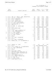
APPENDIX A – STUDENT RADIUS MAP
<strong>Howland</strong> Middle - <strong>Howland</strong> Schools - Trumbull Co<br />
SR-46<br />
NICKLAUS DR<br />
A<br />
N RIVER RD (CR-142)<br />
ME A DOW LN<br />
GRETCHEN DR<br />
REEVES RD (CR-148)<br />
PATCHEN AVE<br />
ORCHARD AVE<br />
FAIRVIEW AVE<br />
WESTOVER DR<br />
HILDA ST<br />
WOODBINE AVE<br />
REEVES RD<br />
KIMBERLY DR<br />
E MARKET ST (CR-329)<br />
CRESTVIEW AVE<br />
k School<br />
OAKLAWN AVE<br />
Students<br />
E HEIGHTS ST<br />
ROSEWAY AVE<br />
Roads by Type<br />
Interstate Route<br />
US Route<br />
State Route<br />
Freeway Ramp<br />
County Roads<br />
Township Roads<br />
NORTH RD (CR-54)<br />
k<br />
82<br />
QUARRY LN<br />
RAGLAN DR<br />
11<br />
k<br />
46<br />
tu 422<br />
NORT H WOOD DR<br />
DEVON DR<br />
BRUCE DR<br />
ADRIAN DR<br />
JEANETTE DR<br />
VALACAMP AVE<br />
SR-82<br />
WELCKER DR<br />
BELLWOOD DR<br />
CRESTVIEW AVE<br />
RAVENWOOD DR<br />
SUNNYBROOK DR<br />
YOUNGSTOWN RD<br />
ALEE SA DR<br />
RAMP G<br />
VICTORIA ST<br />
Radius (Miles)<br />
0.25<br />
0.5<br />
1.0<br />
2.0<br />
City Boundary<br />
County Boundary<br />
State Boundary<br />
RACOON DR<br />
CASTILLION DR<br />
SUTTONPLACE DR<br />
CASTLER OCK DR<br />
ROSEGARDEN DR<br />
GLEN OAKS DR<br />
BROOKWOOD DR<br />
ANDERSON AVE<br />
VENICE DR<br />
WARREN SHARON RD (CR-329)<br />
CLIFTON DR<br />
SR-82<br />
SHAFFER DR<br />
DAWSON DR<br />
Date: 5/21/2012<br />
C H ERRY HILL DR<br />
WE S TWIND DR<br />
FAI RHILL DR<br />
ENGLEWOOD ST<br />
LAUREL W OO D DR<br />
WILLOW DR<br />
SOUTH ST<br />
KENYON DR<br />
BRANDYWINE RD<br />
WILLOW ST<br />
STONECREEK DR<br />
CARRIAGE HILL DR<br />
S HADY LN<br />
SQUIRREL HILL DR<br />
DEER CREEK LN<br />
HIGH ST<br />
STETSON DR<br />
BLACK OAK DR<br />
BAYBER RY DR<br />
SQUIRES LN (CR-363)<br />
KIMBLEWICK LN<br />
SOUTH ST<br />
STONE RIDGE DR<br />
HUNTER S TRL<br />
Total Enrollment = 701<br />
FULLER AVE<br />
SHA DOW OOD LN<br />
CARDIFF LN<br />
HIGHLAND TERRACE BLVD<br />
OLD ORCHARD DR<br />
KING-GRAVES RD (CR-158)<br />
PORTAL DR<br />
WHEELOCK DR<br />
AMBER DR<br />
SHERWOOD DR<br />
SINGING HILLS DR<br />
HOWLAND WILSON RD<br />
HUNTLEY DR<br />
BRADFORD LN<br />
OAKVIEW DR<br />
WO ODHILL DR<br />
ALTURA DR<br />
CAIN DR<br />
HUNT CLUB TRL<br />
HOWLAND SPRINGS RD<br />
EAST POINTE DR<br />
DORAL DR<br />
FIRESTONE DR<br />
VALO<br />
MUIRFIELD DR<br />
q<br />
N DR<br />
DEEPAK DR<br />
PALETTE DR<br />
BAYHILL D R<br />
MINES RD (CR-156)<br />
STILLWAGON RD<br />
STILLWAGON RD (CR-57)<br />
CELESTIAL DR<br />
HENN HYDE RD<br />
SR-11<br />
SCOVILLE DR (CR-590)<br />
Feet<br />
0 750 1,500 3,000 4,500<br />
0 4 8 16 24<br />
Minutes to Walk<br />
CANDYWOOD LN
APPENDIX B – STUDENT TRAVEL TALLY AND PARENT SURVEY
Parent Survey Summary<br />
Program Name: <strong>Howland</strong> SRTS Month and Year<br />
Collected:<br />
September<br />
2012<br />
School Name:<br />
<strong>Howland</strong> Middle<br />
School<br />
Set ID: 8572<br />
School Enrollment: 725 Date Report Generated: 10/23/2012<br />
Enrollment within Grades Targeted by SRTS<br />
Program:<br />
725 Number <strong>of</strong><br />
Questionnaires<br />
Analyzed for Report:<br />
303<br />
Number <strong>of</strong> Questionnaires Distributed: 725<br />
This report contains information from parents about their children's trip to and from school. The report also reflects<br />
parents' perceptions regarding whether walking and bicycling to school is appropriate for their child. The data used in this<br />
report were collected using the Survey about Walking and Biking to School for Parents form from the National Center for<br />
Safe Routes to School.<br />
Sex <strong>of</strong> children for parents that provided information<br />
Page 1 <strong>of</strong> 14
Issues reported to affect the decision to not allow a child to walk or bike to/from school by<br />
parents <strong>of</strong> children who do not walk or bike to/from school<br />
Issues reported to affect the decision to allow a child to walk or bike to/from school by<br />
parents <strong>of</strong> children who already walk or bike to/from school<br />
Page 8 <strong>of</strong> 14
Issues reported to affect the decision to allow a child to walk or bike to/from school by<br />
parents <strong>of</strong> children who already walk or bike to/from school<br />
Issue Child does not walk/bike to school Child walks/bikes to school<br />
Speed <strong>of</strong> Traffic Along Route 84% 33%<br />
Amount <strong>of</strong> Traffic Along Route 83% 33%<br />
Safety <strong>of</strong> Intersections and Crossings 83% 33%<br />
Distance 79% 33%<br />
Weather or climate 68% 100%<br />
Sidewalks or Pathways 59% 0%<br />
Violence or Crime 40% 33%<br />
Time 38% 33%<br />
Crossing Guards 27% 0%<br />
Child's Participation in After School Programs 24% 0%<br />
Adults to Bike/Walk With 14% 0%<br />
Convenience <strong>of</strong> Driving 12% 0%<br />
Number <strong>of</strong> Respondents per Category 208 3<br />
No response: 92<br />
Note:<br />
--Factors are listed from most to least influential for the 'Child does not walk/bike to school' group.<br />
--Each column may sum to > 100% because respondent could select more than issue<br />
--The calculation used to determine the percentage for each issue is based on the 'Number <strong>of</strong> Respondents per Category' within<br />
the respective columns (Child does not walk/bike to school and Child walks/bikes to school.) If comparing percentages between<br />
the two columns, please pay particular attention to each column's number <strong>of</strong> respondents because the two numbers can differ<br />
dramatically.<br />
Page 9 <strong>of</strong> 14
Comments Section<br />
SurveyID<br />
Comment<br />
910143 WE LIVE TO FAR TO WALK OR BIKE<br />
910144 NO<br />
910198 THIS REALLY DOES NOT APPLY BECAUSE OF THE DISTANCE<br />
910206 THE FACT THAT THERE WERE NO BIKE RACKS AT H.C. MINES KEPT MY CHILD FROM RIDING BIKE TO<br />
SCHOOL THE PAST 3 YRS. MY HUSBAND OR I WOULD HAVE BEEN HAPPY TO RIDE WITH HER.<br />
910217 QUESTION #11 - NO I WOULD NOT<br />
910230 N/A QUESTION #11 WEATHER - HOW WOULD THIS CHANGE?<br />
910261 I WOULD LOVE FOR THE HOWLAND COMMUNITY AND SCHOOLS TO MAKE OUR TOWNSHIP EASIER FOR<br />
KIDS TO BIKE AND WALK TO SWCHOOLS AND HOME.<br />
910275 WHY WAS Q #15 ON SURVEY? PERSONAL AND PARENTS SHOULD NOT BE JUDGED BASED ON EDUCATION.<br />
910104 IN ORDER TO GET TO SCHOOL MY CHILD WOULD HAVE TO CROSS 422 AND E. MARKET. HE WOULD HAVE<br />
TO RIDE ALONG N. RD. E. MARKET CROSS OVER THE FREEWAY AND COME UP TO THE SCHOOL W/ TONS<br />
OF TRAFFIC. NO WAY!<br />
910114 I WOULD LOVE FOR MY CHILDREN TO BE ABLE TO RIDE THEIR BIKES TO SCHOOL!!<br />
910256 TOO FAR MY MY CHILDREN TO WALK 5 MILES<br />
910358 THIS IS AN EXTREMELY STUPID SURVEY TO DISTRIBUTE TO NORTHEAST OHIO WHERE WE HAVE HEAVY<br />
SNOW AND EXTREMELY COLD TEMPERATURES FOR MORE THAN HALF OF THE SCHOOL YEAR. MY TAX<br />
DOLLARS BETTER NOT HAVE BEEN WATED ON THIS!!!<br />
910124 IF I LIVED CLOSER I WOULD ALLOW MY CHILD TO WALK TO AND FROM SCHOOL.<br />
910132 MY HUSBAND AND I FEEL MORE COMFORTABLE W/ ALL OF ALL CHILDREN RIDING THE BUS OR BEING<br />
TAKEN TO SCHOOL BY US. THE STREETS ARE TOO BUSY AND THERE ARE TOO MANY CRAZY PEOPLE<br />
OUT THERE KIDNAPPING KIDS SO IT JUST MAKES US FEEL MORE SECURE.<br />
910140 MY CHILD WOULD HAVE TO CROSS E MARKET AND I DO NOT FEEL THAT IT WOULD BE SAFE AT ALL!<br />
910188 WE WOULD NEVER ALLOW OUR CHILDREN TO WALK OR RIDE THEIR BIKES TO AND FROM SCHOOL. IT'S<br />
SIMPLY NOT AN OPTION DUE TO SAFETY!<br />
910295 I WOULD LIKE TO SEE BIKE RACK SO THERE IS PLACE FOR KIDS TO LOCK UP THEIR BIKES LIKE THERE<br />
USED TO BE. MY KIDS WALK ONLY BECAUSE WE DON'T WANT BIKES STOLEN.<br />
910352 I WOULD BE THE MOST WORRIED ABOUT THE OTHER STUDENTS PICKING ON MY CHILD IF SHE WERE TO<br />
WALK TO/FROM SCHOOL. THAT WOULD BE MY MAJOR DESIDING FACTOR.<br />
910353 THANKS FOR CARING ABOUT THE CHILDREN. I WOULDN'T BE SAVE FOR SOME TO WALK FOR VARIOUS<br />
REASONS. QUESTION #10 - I WOULDN'T HAVE HER WALK BUT MY CHILD LIVES VERY CLOSE TO SCHOOL<br />
SO IT'S OK.<br />
910362 WE LIVE ENTIRELY TOO FAR FROM SCHOOL THERE ARE NO SIDE WALKS AND SHE WOULD HAVE TO<br />
TRAVEL MAIN ROADS. NOT TO MENTION THE SEX OFFENDERS AND OTHER "NOT NICE PEOPLE" IN OUR<br />
WORLD!<br />
910382 WOULD LIKE TO KNOW THE PURPOSE OF THE WHILE FORM?<br />
910091 THE BUS SYSTEM IS THE SAFEST WAY TO SCHOOL FOR OUR CHILDREN. PERIOD.<br />
910153 WE LIVE ON A BUSY ROAD AND THE DISTANCE IS TOO FAR. THE ROADS TO THE SCHOOL ARE BUSY AND<br />
THERE IS NO SIDEWALK. I WOULD NOT LET ANY CHILD WALK OR BIKE THE BUSY ROUTE.<br />
910162 WE ARE PART OF OPEN ENROLLMENT PROGRAM AND LIVE TOO FAR FOR WALKING/BIKING TO BE AN<br />
OPTION<br />
910170 WE ARE OPEN ENROLLMENT.<br />
Page 12 <strong>of</strong> 14
910182 I FEEL MY CHILD IS SAFER ON THE SCHOOL BUS.<br />
910197 I FEEL WE DEFINITELY NEED SIDEWALKS MORE IN OUR AREA. IT IS UNSAFE TO HAVE THE CHILDREN<br />
WALK OR RIDE THEIR BIKES ON THE STREET. HOWLAND WILSON RD IS A MAIN RD IN HOWLAND & THIS IS<br />
ONE RD THAT SHOULD HAVE SIDEWALKS. MORE CHILDREN & PARENTS WOULD CONSIDER THESE<br />
OPTIONS IF THEY WERE AVAILABLE. THIS IS SOMETHING I HAVE BEEN ASKING FOR FOR OVER 20 YRS!<br />
910199 I WOULD NEVER FEEL WITH WHERE I LIVE NOW ALLOW MY CHILDREN TO WALK TO SCHOOL. DIFFERENT<br />
TIME FROM OUR CHILDHOOD.<br />
910227 BUSSING MUST BE PROVIDED FOR SAFETY REASONS. IN TODAY'S SOCIETY - IT WOULD NOT BE SAFE TO<br />
HAVE KIDS WALKING/BIKING TO SCHOOL. QUESTION #14 - ASIDE FROM SAFETY ISSUES<br />
910251 THE ROUTE FROM OUR HOUSE TO SCHOOL DOES NOT HAVE SIDEWALKS INTERSECTIONS ARE BUSY.<br />
TRAFFIC IS TO FAST AND DANGEROUS.<br />
910266 I WOULD NOT FEEL SAFE FOR MY SON TO WALK OR BIKE TO AND FROM SCHOOL. TO FAR LOTS TRAFFIC<br />
VIOLENCE AND WEATHER. AGE DON'T CGHANGE THAT!<br />
910376 WE LIVE CLOSE TO THE SCHOOL SO MY CHILD HAS NO MAJOT INTERSECTIONS TO CROSS AND TRAFFIC<br />
IS REALLY LIGHT. WEATHER IS THE ONLY CONCERN FOR WALKING.<br />
910380 THE WEATHER CONDITIONS IN OHIO ONLY ALLOW 1-2 MONTHS OF THE SCHOOL YEAR THAT RIDING A<br />
BIKE IS SAFE. SNOW ICE EXCESSIVE COLDNESS AND RAIN ARE NOT APPROPRIATE FOR BIKE RIDING<br />
910095 I FEEL WE LIVE TOO FAR AND ANY ROUTE TOO DANGEROUS AND I WOULD NEVER LET HER WALK OR<br />
RIDE A BIKE ALONG THAT ROUTE.<br />
910105 TOO DANGEROUS WITH ALL OF THE CRIME AND TRAFFIC FOR KIDS TO WALK OR BICYCLE. WEATHER<br />
ALSO A VERY IMPORTANT ISSUE.<br />
910106 WE LIVE OFF OF RT 46 ON KENYON DR. I WOULDN'T LET ANY OF MY CHILDREN ANY AGE WALK DOWN 46<br />
TO GET TO SCHOOL. TOO MUCH TRAFFIC FAR TOO MANY ACCIDENTS FOR ANY CHILD TO BE WALKING.<br />
910121 WE ARE NOT FOR BUSING OR SCHOOL/TRANSPORTATION BEING REACHED AT THIS TIME SO OUR<br />
CHILDREN CAN RIDE A BIKE OR WALK TO SCHOOL. THERE ARE NO SIDEWALKS & WE LIVE BY A BUSY<br />
INTERSECTION. NOT CHANCING OUR KIDDS LIVES RIDING A BIKE ACROSS 82 TO SCHOOL & FOR BUSING.<br />
910125 JULIE RIDES THE BUS. IF WE LIVED NEXT DOOR TO SCHOOL I WOULD ALLOW HER TO WALK AS SHE<br />
WOULD BE OLD ENOUGH<br />
910166 DO NOT SACRIFICE THE SAFETY OF OUR CHILDREN BY ELIMINATING BUSES AND/OR ROUTES.<br />
910208 WE LIVE TOO FAR AWAY FOR MY CHILD TO WALK OR BIKE TO SCHOOL.<br />
910224 MY DAUGHTER HAS WALKED TO NEARBY FOOD ESTABLISHMENTS WITH FRIENDS AFTER SCHOOL AND<br />
RECEIVED A RIDE FROM MY HUSBAND OR I SHORTLY AFTER. SHE WAS WITH A GROUP & STAYED IN<br />
CONTACT BY PHONE WHILE WALKING. WALKING HOME IS TOO FAR & WOULD NOT BE REASONABLE OR<br />
SAFE.<br />
910274 ITE<strong>MS</strong> CHECKED IN QUESTION 10/11 CAN NOT BE CHANGED FROM WHERE MY CHILDREN LIVE! WHERE<br />
PRESENT SCHOOL LOCATIONS ARE.<br />
910331 I WOULD NOT FEEL COMFORTABLE WITH BIKING OR WALKING<br />
910110 WE PREFER OUR CHILD RIDE SCHOOL BUS.<br />
910135 I WOULD NEVER ALLOW MY CHILD TO WALK OR BIKE TO AND FROM SCHOOL FOR MANY REASONS;<br />
DISTANCE (>2 MILES) TRAFFIC IS HEAVY; UNSAFE AND VIOLENCE AND CRIME CONCERNS. THIS WOULD<br />
BE A HUGE DISAPPOINTMENT IF OUR DISTRICT WOULD GO THIS ROUTE.<br />
910184 RIDING A BUS TO AND FROM SCHOOL IS THE SAFEST MEANS OF TRAVEL.<br />
910212 OUR CHILD HAS A PHYSICAL DISABILITY. WE LIVE TO FAR AND TO MUCH TRAFFIC.<br />
910236 WE DON'T FEEL COMFORTABLE LETTING OUR CHILDREN RIDE BIKES TO SCHOOL.<br />
910238 WE ARE PAYING ENOUGH FOR HOWLAND TAXES THAT THEY SHOULD ALWAYS BE ABLE TO RIPE THE<br />
BUS. AND IT SHOULD ALWAYS BE ABOUT SAFETY NOT SAVING MONEY<br />
Page 13 <strong>of</strong> 14
910342 WE LIVE TOO FAR AWAY FROM SCHOOLS. HAVING A CHILD (AT ANY AGE) CROSS 422 TO EAST MARKET IS<br />
IDIOTIC WALKING OR BIKING.<br />
910350 I LIKE THE IDEA OF KIDS WALKING BUT WE DON'T HAVE A WALKWAY FROM OUR DEVELOPMENT AND ITS<br />
A WOODED AREA. HEAVY BOOKBAGS ARE ANOTHER FACTOR.<br />
910118 VERY BUSY ROAD AND THE CLIMATE IN N.E. OHIO MAKES THIS UNREASONABLE TO ME<br />
910231 THERE IS NO WAY / ROUTE THAT WOULD BE SAFE OR TIME EFFICIENT FOR MY CHILD TO WALK TO<br />
SCHOOL FROM WHERE WE LIVE<br />
910201 CHARLINE HAS SEVER ASTHMA. SHE COULD NOT RIDE OR WALK THAT FAR AND WEATHER IS A BIG<br />
FACTOR FOR HER. IN MY OPINION IT WOULD BE EXTREMELY DANGEROUS WE ARE ON THE OPPOSITE<br />
SIDE OF ROUTE 422 & 82 ITS VERY HIGHLY TRAVELED. SHE WOULD ALSO HAVE TO GET UP AROUND<br />
3:00AM AT LEAST. ITS JUST NOT PLAUSEABLE.<br />
910235 IF SIDEWALKS & CROSS GUARDS IN HOWLAND - I WOULD ALLOW MY CHILD TO WALK TO SCHOOL IN<br />
GROUPS AT APPROPRIATE AGE & WEATHER PERMITTING<br />
910305 THERE ARE WAY TOO MANY WEIRDO'S IN T HE WORLD TO ALLOW MY PRECIOUS CHILD TO WALK OR BIKE<br />
TO SCHOOL!!! YOU CAN NOT STOP CRIME<br />
910138 12. SINCE BUS TRAVELS PAST HOUSE SCHOOL WANT KIDS ON BUS NOT IN LOOP LINE DROPPED OFF. 14.<br />
EXTREMELY BUSY ROADS CHILD COULD GET HURT OR OTHER....<br />
910388 BUSING IS THE ONLY OPTION.<br />
910100 (#13 & #14 ARE NOT APPLICABLE.) I WOULD DEFINITELY NOT ALLOW MY DAUGHTER TO WALK OR BIKE TO<br />
SCHOOL UNDER ANY CIRCU<strong>MS</strong>TANCES.<br />
910259 NORTH RD & E. MARKET IS THE NEXT INTERSECTION AFTER OUR STREET. THERE IS WAY TOO MUCH<br />
TRAFFIC BEFORE AND AFTER SCHOOL TO SAFELY RIDE A BIKE.<br />
910286 MY CHILD HAS TO BE DRIVEN TO SCHOOL. WE HAVE NO BUSES AVAILABLE TO US BY THE DISTRICT AND<br />
WE LIVE W/ IN DISTRICT! I DO NOT FEEL COMFORTABLE ALLOWING HIM TO WALK ALONE AND ALONG<br />
SUCH BUSY ROADS WITH NO SIDEWALKS. BUSES DRIVE PAST OUR HOME DAILY THAT COULD PICKUP<br />
THE CHILDREN IN OUR NEIGHBORHOOD.<br />
910312 I WOULD NOT ALLOW MY CHILDREN TO DAILY CROSS RT. 422 ON BIKE OR ON FOOT. (OR RIDE ALONG<br />
EAST MARKET STREET.)<br />
910340 HOWLAND DOESN'T EVEN HAVE SIDEWALKS? NOT AT ALL FOR ANY SCHOOL AGE CHILD TO WALK TO<br />
SCHOOL. HE STAYS HEALTHLY FRONM SPORTS & ACTIVITIES YEAR ROUND. ALL THESE BAND<br />
INSTRUMENTS & HUGH HEAVY BACKPACKS. GYM CLOTHES DAILY. THIS MAKES NO SENSE!! QUESTION #<br />
13 & 14 - NOT SAFE<br />
Page 14 <strong>of</strong> 14
Tally Report Summary<br />
Program Name: <strong>Howland</strong> SRTS Month and Year Collected: September 2012<br />
School Name: <strong>Howland</strong> Middle School Set ID: 10188<br />
School Enrollment: 725 Date Report Generated: 10/23/2012<br />
Enrollment within Grades Targeted by SRTS Program: 725 Number <strong>of</strong> Classrooms<br />
Included in Report:<br />
34<br />
Number <strong>of</strong> Classrooms in School: 32<br />
This report contains information from parents about their children's trip to and from school. The data used in this report were collected using the<br />
in-class Student Travel Tally questionnaire from the National Center for Safe Routes to School.<br />
Morning and Afternoon Travel Mode Comparison<br />
Morning and Afternoon Travel Mode Comparison<br />
Number<br />
<strong>of</strong> Trips<br />
Walk<br />
Bike<br />
School<br />
Bus<br />
Family<br />
Vehicle<br />
Carpool Transit Other<br />
Morning 1301 2% 0% 81% 16% 0.6% 0.2% 0.1%<br />
Afternoon 1272 4% 0% 73% 21% 2% 0.2% 0.3%<br />
Percentages may not total 100% due to rounding.<br />
Page 1 <strong>of</strong> 3
APPENDIX C – HOWLAND MIDDLE SCHOOL BUS POLICY
APPENDIX D – COUNTERMEASURE MAPS
APPENDIX E – PUBLIC INPUT INFORMATION
Mobile: mobile.tribtoday.com<br />
Sign In | Create an Account | Subscribe | Submit News | Place An Ad | Home<br />
News Opinion Sports Society Classified Special Sections Features Extras Jobs CU Forums Blogs Contact Us<br />
What's Trending » 1) Scandal rocks JFK<br />
News, Blogs & Events SEARCH<br />
Local News<br />
■<br />
■<br />
Local News<br />
Breaking Nation/State<br />
News<br />
■ Business<br />
■ Shale and Gas Drilling<br />
■ Community News<br />
■ Obituaries<br />
■ Opinion<br />
■ Columns<br />
■ <strong>Ohio</strong> News<br />
■ National News<br />
■ International News<br />
■ Stocks and Lottery<br />
■ SUBMIT News<br />
■ Community STARS<br />
■ Halloween<br />
■ Christmas story 2012<br />
/ News / Local News /<br />
« Woman who scalded toddler se... Home sweet home»<br />
A safe route to school?<br />
District’s plan to encourage walking, biking raises<br />
concerns<br />
December 10, 2012<br />
By MARGARET THOMPSON - Staff reporter (mthompson@tribtoday.com) , Tribune<br />
Chronicle | TribToday.com<br />
Tribune Chronicle<br />
Save | Comments (12) | Post a comment |<br />
HOWLAND - A proposal to keep middle-school students safer while<br />
walking to school brought concern from parents and faculty, who<br />
didn't care for the proposed construction <strong>of</strong> a new drop-<strong>of</strong>f / pick-up<br />
area for middle-schoolers.<br />
The new area was part <strong>of</strong> a plan devised by consultants funded<br />
through a $5,000 <strong>Ohio</strong> <strong>Department</strong> <strong>of</strong> <strong>Transportation</strong> grant.<br />
Proposed changes would cost $593,000 to reduce traffic congestion<br />
and promote a safe environment encouraging children to walk or<br />
bike to school.<br />
The school, which sits behind the <strong>Howland</strong> Plaza, is essentially boxed<br />
in by East Market Street, state Route 46 and state Route 82.<br />
Currently 102 students live within one mile <strong>of</strong> the school, but only 2<br />
percent, about 14 students, walk to school. The Safe Routes to<br />
School Program hopes to increase that percentage.<br />
After evaluating the school area, observing the arrival and dismissal<br />
<strong>of</strong> students, completing a walking audit and surveying parents, John<br />
Brigham, supervising traffic engineer, and the rest <strong>of</strong> the consultant<br />
team presented their findings and suggestions.<br />
Brigham said the largest problems include congestion on Brewster<br />
Drive during dismissal, traffic signals deficiencies and heavy traffic<br />
on East Market Street.<br />
According to the consultant's findings, 84 percent <strong>of</strong> parents said<br />
they would not allow their children to walk to school because <strong>of</strong> the<br />
speed <strong>of</strong> the traffic along the route, and 83 percent were concerned<br />
about the safety <strong>of</strong> intersections and crossings.<br />
The consultants devised several changes to improve safety in the<br />
school's vicinity. Proposed physical changes included installing bike<br />
racks, correcting faulty crosswalk signals and converting the<br />
intersection <strong>of</strong> Willow Street, South Street and Brewster into a three<br />
-way stop.<br />
The most drastic change proposed was installing approximately 175<br />
feet <strong>of</strong> new sidewalk from the school's entrance on Brewster to the<br />
southeast high school parking lot as a new pick-up / drop-<strong>of</strong>f<br />
location. The location would eliminate congestion at dismissal as well<br />
as lessen the number <strong>of</strong> parents illegally parking by the middle<br />
school. It also would require students to cross the heavily traveled<br />
East Market Street.<br />
Warren, OH<br />
I am looking for:<br />
32°F<br />
Extended Forecast<br />
Find Another Location<br />
Data provided by The Weather Channel ®<br />
Online Safety Degree<br />
www.ColumbiaSouthern.edu<br />
Accredited Online Degree Program. Study<br />
Anywhere, BCSP Recognized<br />
Community College<br />
www.Herzing.edu/Akron<br />
Begin a New Career with a Degree in<br />
Business, Healthcare or Technology.<br />
Engineering Leadership<br />
Stanford.edu<br />
Stanford University Management Science &<br />
Engineering Certificate.<br />
SEARCH
This proposed change was not well received by parents at the<br />
presentation.<br />
"I think our parents' biggest concern is students crossing East<br />
Market," said Ann Marie Thigpen, <strong>Howland</strong> Local School District<br />
administrator.<br />
"They don't want their children to walk seven feet," Virginia Stec<br />
said, "let alone to the high school."<br />
Stec said she waits in the long traffic line on Brewster every day to<br />
pick up her grandchild.<br />
Tina Slyk picks up her two children for medical reasons and said<br />
before she would agree to pick them up at the high school parking<br />
lot, she would need to see more details. She said she would prefer<br />
for more options to be explored on campus.<br />
Non-infrastructure changes that were proposed included holding a<br />
bicycle rodeo and a Walk to School Day.<br />
In addition, the consultants suggested stricter enforcement <strong>of</strong> illegal<br />
parking near the school and a "walking school bus." The walking<br />
school bus consists <strong>of</strong> a volunteer walking from house to house<br />
leading children to school on foot.<br />
Hope Myers has a daughter in sixth grade who is within walking<br />
distance <strong>of</strong> the school. However, the fact that her daughter would be<br />
walking alone and crossing over busy streets deters her from<br />
allowing her child to walk.<br />
"It only takes one weirdo," Myers said.<br />
She said the idea <strong>of</strong> a walking school bus would work well in her<br />
situation.<br />
The consultants will use the parents' suggestions to revise the plan.<br />
Funding for the revised plan will begin as soon as January, according<br />
to Kim Mascarella, township director <strong>of</strong> planning and zoning.<br />
© Copyright 2013 Tribune Chronicle | TribToday.com. All rights reserved. This material<br />
may not be published, broadcast, rewritten or redistributed.<br />
Save | Comments (12) | Post a comment |<br />
Recommend<br />
0<br />
Send<br />
29 people recommend this. Sign Up to see what your<br />
friends recommend.<br />
Subscribe to Tribune Chronicle | TribToday.com<br />
Tribune Chronicle | TribToday.com<br />
240 Franklin Street SE , Warren, OH 44483 |<br />
© 2013. All rights reserved.| Terms <strong>of</strong> Service and Privacy Policy