Niles Canyon 2 - Caltrans - State of California
Niles Canyon 2 - Caltrans - State of California
Niles Canyon 2 - Caltrans - State of California

You also want an ePaper? Increase the reach of your titles
YUMPU automatically turns print PDFs into web optimized ePapers that Google loves.
Route 84 Safety Improvement Project<br />
(<strong>Niles</strong> <strong>Canyon</strong> 2)<br />
<strong>State</strong> <strong>of</strong> <strong>California</strong><br />
Department <strong>of</strong> Transportation<br />
District 4
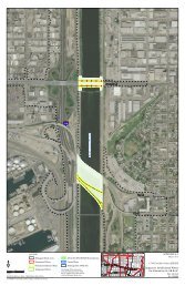
ROUTE 84 IN NILES CANYON<br />
EXISTING CONDITIONS<br />
• Two-lane conventional highway in a rural setting<br />
• Narrow shoulders (2-8 feet in width)<br />
• Typically curving horizontal alignment<br />
• Generally bounded by a steep canyon wall, Alameda<br />
Creek, and railroad<br />
• Regulatory speed is 45 MPH; curve warning speed<br />
signs to 30-35 MPH at spot locations<br />
• 14,000 AATD with 2.5% truck traffic
EXISTING CONDITIONS<br />
Sta 22+00
EXISTING CONDITIONS<br />
Sta 146+80 Railroad & sack wall on left
BACKGROUND<br />
• In 2003 a <strong>Caltrans</strong> safety analysis found a rate <strong>of</strong> crosscenterline<br />
fatal collisions that were higher than statewide<br />
averages for similar facilities.<br />
• Combined with higher anticipated future traffic volumes<br />
and accident history, <strong>Caltrans</strong> initiated a project to improve<br />
safety on Route 84 in <strong>Niles</strong> <strong>Canyon</strong>.<br />
• Proposed safety improvements include the following:<br />
– Standard shoulders<br />
– S<strong>of</strong>t median barrier<br />
– Shoulder rumble strip
BACKGROUND – RUMBLE STRIP<br />
• In March 1999 <strong>Caltrans</strong> placed a moratorium on the<br />
installation <strong>of</strong> ground in rumble strip due to concerns<br />
expressed by the bicycle community.<br />
• In September 1999 <strong>Caltrans</strong> began a study with the goal <strong>of</strong><br />
developing a shoulder rumble strip that was effective in<br />
reducing run-<strong>of</strong>f the road accidents and could be traversed by<br />
bicyclists.<br />
• Completed in May 2001, the study evaluated several designs<br />
and recommended use <strong>of</strong> a ground in rumble strip that became<br />
Standard Plan A40B that is used throughout the <strong>State</strong> today<br />
where bicycle travel is permitted.
STANDARD PLAN A40B<br />
(GROUND IN RUMBLE STRIP)
STANDARD PLAN A40B<br />
(GROUND IN RUMBLE STRIP)
PROJECT DESCRIPTION<br />
TYPICAL CROSS SECTION (CUT SLOPE)
PROJECT DESCRIPTION<br />
TYPICAL CROSS SECTION (FILL SLOPE)
PROJECT BENEFITS<br />
Standard shoulders provide the following safety<br />
improvements:<br />
• Room for vehicles leaving the lane to safely recover,<br />
reducing run-<strong>of</strong>f the road and hit obstacle accidents<br />
• Reduce head-on collisions due to driver overcorrection<br />
• Room for emergency use by disabled vehicles<br />
• Increased horizontal stopping sight distance on curves<br />
• Improve safety for bicycle travel
PROJECT BENEFITS<br />
• S<strong>of</strong>t median barrier (centerline rumble strip) acts a<br />
“buffer” that provides an audible and physical warning<br />
to motorists crossing over centerline towards<br />
oncoming traffic<br />
• Shoulder rumble strip enhances bicycle safety as it acts<br />
as a “s<strong>of</strong>t barrier” between vehicular and bicycle traffic<br />
and provides an effective means <strong>of</strong> locating the lane<br />
edge during inclement weather or poor/limited<br />
visibility
VISUAL IMPACTS
KEY VIEWPOINT – PALOMA WAY<br />
View<br />
looking<br />
west, just<br />
west <strong>of</strong> the<br />
I-680<br />
<strong>of</strong>framp.<br />
• Walnut tree removal along the northern half <strong>of</strong> the tree allee<br />
• Walnut trees on the north side are in declining in health<br />
• Save healthy Sycamore trees to the south<br />
• Opens up views <strong>of</strong> the rolling hills beyond
KEY VIEWPOINT – AT POST MILE 16.0<br />
View looking westward, from a<br />
viewpoint just 1.0 mile east <strong>of</strong> the<br />
<strong>Niles</strong> <strong>Canyon</strong> Railroad maintenance<br />
yard.<br />
• Install an 8-12 foot tall upslope retaining wall with rusticated ashlar masonry treatment<br />
• Retain as much existing vegetation to the extent possible<br />
• Relocate historic telegraph poles<br />
• Stain concrete safety barrier to blend with wall
KEY VIEWPOINT – NEAR POST MILE 15.5<br />
View looking<br />
west at a<br />
location + 0.5<br />
mile east <strong>of</strong><br />
the <strong>Niles</strong><br />
<strong>Canyon</strong><br />
Railroad<br />
maintenance<br />
yard.<br />
• Install a maximum 20 foot tall upslope retaining wall, and 4-10 foot tall downslope wall<br />
• Retain as much existing vegetation to the extent possible<br />
• Stain concrete safety barrier to blend with wall<br />
• Upslope wall to have rusticated ashlar masonry treatment
KEY VIEWPOINT – NEAR POST MILE 14.1<br />
View<br />
looking<br />
west, just<br />
west <strong>of</strong><br />
where the<br />
aqueduct<br />
appears<br />
adjacent<br />
to the<br />
roadway.<br />
• Install upslope retaining walls 9 to 17 foot tall, and a 6 to 10 foot tall downslope wall<br />
• Retain as much existing vegetation to the extent possible<br />
• Stain concrete safety barrier to blend with wall<br />
• Removing the trees increases safety, sight distance and visibility
KEY VIEWPOINT – NEAR POST MILE 14.1<br />
View<br />
looking<br />
west, west<br />
<strong>of</strong> where<br />
the<br />
aqueduct<br />
appears<br />
adjacent<br />
to the<br />
roadway.<br />
• Install upslope retaining walls 9 to 17 foot tall, and a 6 to 10 foot tall downslope wall<br />
• Retain as much existing vegetation to the extent possible<br />
• Stain concrete safety barrier to blend with wall
KEY VIEWPOINT – NEAR POST MILE 14.0<br />
View<br />
looking<br />
west from<br />
the location<br />
<strong>of</strong> the<br />
Eucalyptus<br />
trees.<br />
• Removal <strong>of</strong> the Blue Gum eucalyptus trees along the east side <strong>of</strong> Route 84<br />
• The grouping <strong>of</strong> eucalyptus were studied and not found to be identified as possessing historic significance, nor were they considered a<br />
scenic resource<br />
• Removing the trees increases safety, sight distance, visibility and opens up a scenic vista<br />
• Install upslope retaining walls 10 to 14 foot tall
PROJECT COST<br />
Construction Cost<br />
R/W Cost<br />
Total Capital cost<br />
$ 34.2 M<br />
$ 1.8 M<br />
$ 36.0 M<br />
Funding SHOPP *<br />
* <strong>State</strong> Highway Operations & Protection Program
PROJECT SCHEDULE<br />
• Draft Environmental Document July 2010<br />
• Environmental Approval Feb 2011<br />
• Design Engineering Complete May 2012<br />
• Right-<strong>of</strong>-way Certification May 2012<br />
• Advertise Project Aug 2012<br />
• Start Construction Dec 2012<br />
• Construction Complete Dec 2014
END