

The New Zealand Sealing Industry - Department of Conservation
The New Zealand Sealing Industry - Department of Conservation
The New Zealand Sealing Industry - Department of Conservation

You also want an ePaper? Increase the reach of your titles
YUMPU automatically turns print PDFs into web optimized ePapers that Google loves.
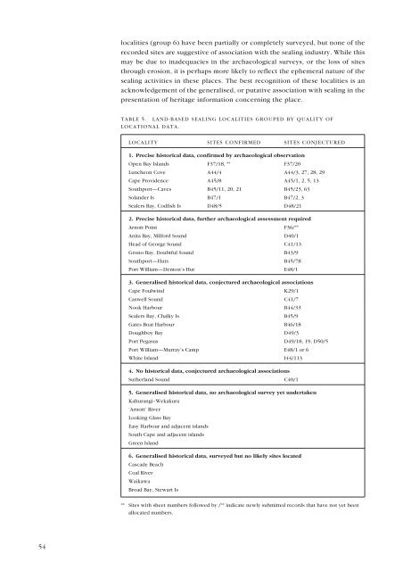
localities (group 6) have been partially or completely surveyed, but none <strong>of</strong> the<br />
recorded sites are suggestive <strong>of</strong> association with the sealing industry. While this<br />
may be due to inadequacies in the archaeological surveys, or the loss <strong>of</strong> sites<br />
through erosion, it is perhaps more likely to reflect the ephemeral nature <strong>of</strong> the<br />
sealing activities in these places. <strong>The</strong> best recognition <strong>of</strong> these localities is an<br />
acknowledgement <strong>of</strong> the generalised, or putative association with sealing in the<br />
presentation <strong>of</strong> heritage information concerning the place.<br />
TABLE 5. LAND-BASED SEALING LOCALITIES GROUPED BY QUALITY OF<br />
LOCATIONAL DATA.<br />
LOCALITY SITES CONFIRMED SITES CONJECTURED<br />
1. Precise historical data, confirmed by archaeological observation<br />
Open Bay Islands F37/18, ** F37/20<br />
Luncheon Cove A44/4 A44/3, 27, 28, 29<br />
Cape Providence A45/8 A45/1, 2, 5, 13<br />
Southport—Caves B45/11, 20, 21 B45/23, 63<br />
Solander Is B47/1 B47/2, 3<br />
Sealers Bay, Codfish Is D48/5 D48/21<br />
2. Precise historical data, further archaeological assessment required<br />
Arnott Point<br />
F36/**<br />
Anita Bay, Milford Sound D40/1<br />
Head <strong>of</strong> George Sound C41/13<br />
Grono Bay, Doubtful Sound B43/9<br />
Southport—Huts B45/78<br />
Port William—Denton’s Hut E48/1<br />
3. Generalised historical data, conjectured archaeological associations<br />
Cape Foulwind K29/1<br />
Caswell Sound C41/7<br />
Nook Harbour B44/33<br />
Sealers Bay, Chalky Is B45/9<br />
Gates Boat Harbour B46/18<br />
Doughboy Bay D49/3<br />
Port Pegasus D49/18, 19, D50/5<br />
Port William—Murray’s Camp E48/1 or 6<br />
White Island I44/113<br />
4. No historical data, conjectured archaeological associations<br />
Sutherland Sound C40/1<br />
5. Generalised historical data, no archaeological survey yet undertaken<br />
Kahurangi–Wekakura<br />
‘Arnott’ River<br />
Looking Glass Bay<br />
Easy Harbour and adjacent islands<br />
South Cape and adjacent islands<br />
Green Island<br />
6. Generalised historical data, surveyed but no likely sites located<br />
Cascade Beach<br />
Coal River<br />
Waikawa<br />
Broad Bay, Stewart Is<br />
** Sites with sheet numbers followed by /** indicate newly submitted records that have not yet been<br />
allocated numbers.<br />
54


