Tri-Valley Wildlife Area - Ohio Department of Natural Resources
Tri-Valley Wildlife Area - Ohio Department of Natural Resources
Tri-Valley Wildlife Area - Ohio Department of Natural Resources

Create successful ePaper yourself
Turn your PDF publications into a flip-book with our unique Google optimized e-Paper software.
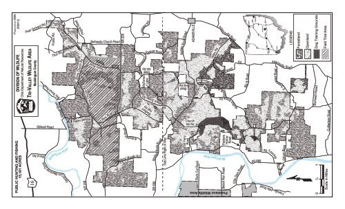
PUBLIC HUNTING AND FISHING<br />
15,181 ACRES<br />
16<br />
SR 208<br />
Gene<br />
Cox Memorial Drive<br />
Burvil Rd.<br />
Muskingum River<br />
Stillwell Road<br />
Stillwell HillRd.<br />
Stillwell Road<br />
DIVISION OF WILDLIFE<br />
<strong>Ohio</strong> <strong>Department</strong> <strong>of</strong> <strong>Natural</strong> <strong>Resources</strong><br />
TRI-VALLEY WILDLIFE AREA<br />
Muskingum County<br />
Boy Scout Road<br />
Titus Rd.<br />
Fostor Rd.<br />
Bethesda Church Road<br />
PUBLICATION 5099<br />
(R0913)<br />
Pear Orchard Rd.<br />
Hogue Road<br />
SR 666<br />
Copeland Woods Rd<br />
Mollie s Rock Road<br />
Gas Line Right <strong>of</strong> Way<br />
N Branch Road<br />
Black Snake Rd.<br />
McFerren<br />
Lane<br />
Prospe c t C<br />
hurch Rd<br />
Radcliff Road<br />
SR 208<br />
Summers R d<br />
Old Ferry<br />
Road<br />
Mollies R ock Road<br />
Powelson <strong>Wildlife</strong> <strong>Area</strong><br />
Rock Cut Road<br />
Beech Run Road<br />
Ellis Dam Road<br />
Muskingum River<br />
Painters<br />
Hollow<br />
Road<br />
idge Rd<br />
Mutton R<br />
She ck Rd<br />
Ferrell<br />
ADAMSVILLE<br />
Adam sville Road<br />
Rd<br />
Big B Road<br />
Friendly Hills Road<br />
SR 666<br />
M<br />
Rd<br />
e mor y<br />
Gilbert Road<br />
E Greenwood Road<br />
Adamsville<br />
Roa<br />
d<br />
LEGEND<br />
N Forestland<br />
Openland<br />
0 1<br />
/2 1<br />
Burwell Road<br />
Dog Training Grounds<br />
Scale in Miles<br />
Culbertson Road<br />
Field <strong>Tri</strong>al <strong>Area</strong>
SIGN 83A<br />
WILDLIFE<br />
AREA<br />
Public Hunting - Fishing<br />
DIVISION OF WILDLIFE<br />
<strong>Ohio</strong> <strong>Department</strong> <strong>of</strong> <strong>Natural</strong> <strong>Resources</strong><br />
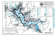
Location and Description<br />
This 15,181-acre area lies east <strong>of</strong> the Muskingum River 1/2 mile from Dresden and 4 1/2 miles north <strong>of</strong> Zanesville.<br />
State routes 208, 93 and 666 provide easy access to the many county and township roads that transect the area.<br />
The topography includes gently rolling hills to steep hills along the Muskingum River. Approximately 40 percent<br />
<strong>of</strong> the area is reclaimed strip mine ground consisting <strong>of</strong> predominately grass cover; the remaining 60 percent consist<br />
<strong>of</strong> woodlands in various size classes and species composition. Portions <strong>of</strong> the area have been strip mined and not<br />
reclaimed, these areas have steep hills and caution should be used when walking in these areas.<br />
History and Purpose<br />
This area purchased from Barrick Gold Mining Company in 1996 has seen many disturbances from agriculture,<br />
oil/gas exploration and strip mining that have formed the landscape found here today. Strip mining activities have<br />
had the most recent influence on the landscape resulting in large grassland areas not commonly found in the unglaciated<br />
portion <strong>of</strong> <strong>Ohio</strong>. Active strip mining and oil and gas exploration may be an ongoing activity and could<br />
cause temporary closure to portions <strong>of</strong> the area.<br />
Forest management <strong>of</strong> the area includes timber sales, firewood sales, release cutting and timber stand improvement.<br />
Grassland management includes prescribed fire, and chemical and mechanical vegetation control to slow succession<br />
and encourage warm season grass growth. Cooperative farming and planting <strong>of</strong> dove fields and food plots are also<br />
practiced on the area.<br />
Fish and <strong>Wildlife</strong><br />
The principle game species include white-tailed deer, wild turkey, gray and fox squirrel, mourning dove and cottontail<br />
rabbit. Bobwhite quail are also present although no open season occurs on this area. All furbearers common to the<br />
region are found on the area. Various species <strong>of</strong> waterfowl can be found using the ponds and wetlands for nesting<br />
and migration resting areas.<br />
Ponds are interspersed throughout the area; they may contain largemouth bass, bluegill, and channel catfish. Many<br />
songbirds, small mammals, reptiles, amphibians, and insects also occur in the area with the diverse mixture <strong>of</strong> habitats.<br />
TRI-VALLEY WILDLIFE AREA<br />
Muskingum County<br />
Distance from major<br />
population centers<br />
13 miles from Zanesville<br />
21 miles from Coshocton<br />
30 miles from Cambridge<br />
65 miles from Athens<br />
Hunting, Trapping and Fishing<br />
This area is most popular for white-tailed deer, wild turkey, cottontail rabbit, squirrel, and dove hunting. Deer, turkey,<br />
squirrel, and raccoon hunters will find the forested areas the preferred spots to pursue these animals. Rabbit hunters<br />
will find abundant opportunity in the grass/brush cover <strong>of</strong> the open reclaimed strip mined areas. Dove hunters will<br />
want to hunt the established dove fields, planted and manipulated specifically for dove hunting. Limited waterfowl<br />
hunting is available on the areas ponds and wetland during the fall migration. General trapping is permitted on the<br />
area; however, beaver trapping is restricted to a special drawing.<br />
Limited fishing for largemouth bass, bluegill, and channel catfish is available in area ponds.<br />
Public use Facilities<br />
Several parking lots are available and good access is provided by secondary roads throughout the area. An archery range<br />
is available to the public from sunrise to sunset for practice. Targets are set at distances <strong>of</strong> 10 to 40 yards, and 10 to<br />
15 meters. An elevated platform is available at the facility located on Memory Road near the ODNR Nursery Office.<br />
A dog training area for exercising and training dogs from May 1-August 31 is located adjacent to Churchill Road<br />
south <strong>of</strong> Salem Cemetery. A field trial area is located on the northern end <strong>of</strong> the area and is open to public hunting.<br />
Additional Information<br />
Further information may be obtained from the <strong>Area</strong> Manager, Woodbury <strong>Wildlife</strong> <strong>Area</strong>, 23371 SR 60 S., Warsaw,<br />
<strong>Ohio</strong> 43844, telephone (740) 824-3211; or the <strong>Wildlife</strong> District Four Office, 360 East State St., Athens, <strong>Ohio</strong><br />
43701, telephone (740) 589-9930.<br />
TURN IN A POACHER<br />
<strong>Ohio</strong>’s TIP (Turn In a Poacher) program helps to curtail poaching throughout the state. TIP is designed to involve<br />
the public in reporting wildlife violations. Citizens who observe wildlife violations should call the TIP toll-free<br />
hotline, 1-800-POACHER.