Ohio River Reciprocal Agreement - Ohio Department of Natural ...
Ohio River Reciprocal Agreement - Ohio Department of Natural ...
Ohio River Reciprocal Agreement - Ohio Department of Natural ...

Create successful ePaper yourself
Turn your PDF publications into a flip-book with our unique Google optimized e-Paper software.
<strong>Ohio</strong> <strong>River</strong> <strong>Reciprocal</strong> <strong>Agreement</strong><br />
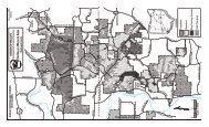
<strong>Ohio</strong> embayments along West Virginia’s border with recommended reciprocal boundaries. All significant embayments are listed.<br />
Fishing<br />
West Virginia fishing regulations must be<br />
followed when fishing on the <strong>Ohio</strong> <strong>River</strong><br />
proper and on embayments or tributaries<br />
that are within the boundaries <strong>of</strong> West<br />
Virginia.<br />
<strong>Ohio</strong> <strong>River</strong> fishing regulations for the<br />
Eastern Unit must be followed while<br />
fishing on embayments or tributaries that<br />
are within the boundaries <strong>of</strong> <strong>Ohio</strong>; see<br />
<strong>Ohio</strong> Fishing Regulations (Publication<br />
84). Please refer to the respective state<br />
fishing regulations for other information,<br />
as well as dates <strong>of</strong> free fishing days that are<br />
<strong>of</strong>fered by each state. Please contact the<br />
West Virginia DNR’s Charleston Office<br />
to schedule fishing tournaments, which<br />
require a permit. Also, please see the <strong>Ohio</strong><br />
<strong>River</strong> Fishing Guide (available from either<br />
state) for access locations and Corps <strong>of</strong><br />
Engineers contact information.<br />
Stream <strong>Ohio</strong> <strong>River</strong> Mile <strong>River</strong> Side Landmark Miles Above Mouth GPS Coordinates<br />
Little Yellow Creek 47.2 OH SR 7 bridge 0.2 40° 36’ 51.74”N, 80° 38’ 29.27”W<br />
Yellow Creek 50.5 OH SR 213 bridge 2.6 40° 34’ 20.88”N, 80° 40’ 05.48”W<br />
Indian Cross Creek 71.7 OH SR 7 bridge 0.9 40° 18’ 58.39”N, 80° 36’ 49.50”W<br />
Indian Short Creek 81.4 OH SR 150 bridge 0.8 40° 11’ 17.17”N, 80° 41’ 35.14”W<br />
Captina Creek 109.6 OH SR 148 bridge 2.1 39° 52’ 04.16”N, 80° 49’ 39.31”W<br />
Sunfish Creek 118 OH slack water to power line ~ 1.9 mi 1.9 39° 45’ 25.53”N, 80° 53’ 18.31”W<br />
Opossum Creek 119.9 OH slack water extends ~ 0.6 mi 0.6 39° 43’ 46.13”N, 80° 51’ 23.37”W<br />
Leith’s Run 150 OH slack water extends ~ 0.4 mi 0.4 39° 26’ 45.11”N, 81° 08’ 57.54”W<br />
Dana’s Run 156.8 OH slack water extends ~ 0.7 mi 0.7 39° 23’ 59.85”N, 81° 14’ 17.12”W<br />
Newell Run 158.5 OH slack water extends ~ 0.5 mi 0.5 39° 23’ 18.26”N, 81° 16’ 28.87”W<br />
Bells Run 160.1 OH slack water extends ~ 0.2 mi 0.2 39° 22’ 36.60”N, 81° 17’ 47.84”W<br />
Little Muskingum <strong>River</strong> 168.3 OH Cornersville bridge 2.6 39° 23’ 41.44”N, 81° 22’ 31.70”W<br />
Duck Creek 170.7 OH SR 26 bridge 1.7 39° 25’ 34.57”N, 81° 25’ 17.78”W<br />
Muskingum <strong>River</strong> 172.2 OH Devola Dam 6 39° 28’ 11.31”N, 81° 29’ 29.81”W<br />
Little Hocking <strong>River</strong> 192 OH Rt fork to confluence <strong>of</strong> Little West Branch 3.5 39° 17’ 02.21”N, 81° 42’ 41.66”W<br />
Lt fork to TWP Rd 189 bridge 4.6 39° 16’ 49.35”N, 81° 44’ 21.26”W<br />
Swan Run 198.3 OH slack water extends ~ 0.5 mi 0.5 39° 11’ 41.05”N, 81° 44’ 28.13”W<br />
Hocking <strong>River</strong> 199.4 OH slack water extends to Federal Creek confluence 17.4 39° 19’ 09.96”N, 81° 52’ 45.88”W<br />
Indian Run 200.3 OH slack water extends ~ 0.9 mi 0.9 39° 09’ 55.72”N, 81° 45’ 57.87”W<br />
Sugar Camp Run 202.4 OH slack water extends ~ 0.8 mi 0.8 39° 08’ 42.18”N, 81° 45’ 21.07”W<br />
Shade <strong>River</strong> 210.8 OH slack water extends to Spruce Creek @ normal pool 3.2 39° 04’ 18.05”N, 81° 49’ 59.73”W<br />
Old Town Creek 226.3 OH slack water extends ~ 1.5 mi @ normal pool 1.5 38° 57’ 32.31”N, 81° 49’ 26.49”W<br />
Leading Creek 254.2 OH Railroad bridge 1.5 38° 59’ 30.96”N, 82° 04’ 23.50”W<br />
Campaign Creek 262.4 OH power line crossing @ 0.8 mi 0.8 38° 52’ 59.27”N, 82° 08’ 57.55”W<br />
Chickamauga Creek 270.1 OH SR 588 bridge 1 38° 48’ 41.10”N, 82° 12’ 29.86”W<br />
Raccoon Creek 276 OH SR 218 bridge @ Thivener 5.8 38° 44’ 12.29”N, 82° 14’ 42.29”W<br />
Indian Guyan Creek 306 OH slack water extends ~ 1.7 mi @ normal pool 1.7 38° 26’ 52.73”N, 82° 23’ 47.12”W<br />
Symmes Creek 308.7 OH slack water extends ~ 1.35 mi @ normal pool 1.35 38° 26’ 05.03”N, 82° 27’ 42.47”W<br />
West Virginia embayments and tributaries with recommended reciprocal boundaries. The boundary for areas not listed would extend to the first riffle.<br />
Stream WV <strong>River</strong> Mile <strong>River</strong> Side Landmark Miles Above Mouth GPS Coordinates<br />
Wheeling Creek 90.7 WV I-70 Bridge 1.7 40° 04’ 24.40”N, 80° 42’ 45.45”W<br />
Fish Creek 113.8 WV Graysville Bridge 2.1 39° 48’ 58.36”N, 80° 47’ 50.26”W<br />
Fishing Creek 128.4 WV State Route 7 Bridge 2.6 39° 37’ 04.88”N, 80° 50’ 50.46”W<br />
Middle Island Creek 154.1 WV Mouth <strong>of</strong> McKim Creek 4.6 39° 23’ 26.85”N, 81° 08’ 19.78”W<br />
French Creek 157.7 WV Rt. 18 Bridge 1.7 39° 22’ 06.47”N, 81° 14’ 22.58”W<br />
Little Kanawha <strong>River</strong> 184.5 WV Mouth <strong>of</strong> Slate Creek 15.3 39° 08’ 15.23”N, 81° 26’ 34.27”W<br />
Little Sand Creek 193.9 WV Rt. 892 Bridge 1.4 39° 13’ 33.67”N, 81° 40’ 39.72”W<br />
Lee Creek 201.8 WV Mouth <strong>of</strong> North Fork 2.2 39° 09’ 10.49”N, 81° 43’ 11.41”W<br />
Mill Creek 231.3 WV Cottageville Bridge 4.4 39° 52’ 02.29”N, 81° 49’ 07.48”W<br />
Kanawha <strong>River</strong> (no tributaries) 265.7 WV Buffalo Bridge 24.3 38° 35’ 01.28”N, 82° 00’ 00.79”W<br />
Guyandotte <strong>River</strong> 305.3 WV Interstate 64 Bridge 6.5 38° 25’ 20.14”N, 82° 17’ 57.04”W<br />
Twelvepole Creek 313.4 WV Rt. 60 Bridge 0.9 38° 23’ 46.69”N, 82° 32’ 29.12”W<br />
Big Sandy <strong>River</strong> - Because this river is shared with Kentucky, it is not included in this agreement.
Waterfowl Hunting<br />
Under current federal waterfowl management regulations West Virginia is in the Atlantic Flyway and <strong>Ohio</strong> is in the<br />
Mississippi Flyway. Therefore, each state may have different waterfowl hunting seasons and regulations. Hunters are<br />
reminded that opening and closing dates, bag limits, and other regulations may vary between <strong>Ohio</strong> and West Virginia.<br />
It is the hunter’s responsibility to know and comply with the existing laws, rules and regulations (see West Virginia or<br />
<strong>Ohio</strong> hunting and trapping regulation digests and the respective state’s migratory waterfowl hunting regulations).<br />
Waterfowl shooting may take place on/over the <strong>Ohio</strong> <strong>River</strong> and West Virginia embayments/tributaries only during<br />
West Virginia’s open season. Hunters may not hunt from the <strong>Ohio</strong> bank <strong>of</strong> the river when the <strong>Ohio</strong> season is closed.<br />
When hunting in <strong>Ohio</strong> while the West Virginia season is closed, hunting will be allowed only on <strong>Ohio</strong> <strong>River</strong><br />
embayments or tributaries that are within the boundaries <strong>of</strong> <strong>Ohio</strong>.<br />
Waterfowl Hunting and Fishing on the <strong>Ohio</strong> <strong>River</strong><br />
RECIPROCAL AGREEMENT BETWEEN<br />
WEST VIRGINIA AND OHIO<br />
West Virginia does not allow Sunday hunting. Therefore, the <strong>Ohio</strong> <strong>River</strong> and the embayments and tributaries that are<br />
within the boundaries <strong>of</strong> West Virginia are closed to all hunting on Sunday. Sunday waterfowl hunting is only allowed<br />
on embayments and tributaries that are within the boundaries <strong>of</strong> <strong>Ohio</strong>, and only during the <strong>Ohio</strong> season. On Sundays,<br />
hunters are reminded that they may not shoot waterfowl that are flying over the <strong>Ohio</strong> <strong>River</strong> from the <strong>Ohio</strong> shoreline.<br />
Waterfowl legally shot in the state <strong>of</strong> <strong>Ohio</strong>, that fall into the <strong>Ohio</strong> <strong>River</strong> during a closed West Virginia season may be retrieved from the <strong>Ohio</strong><br />
<strong>River</strong> mainstem. Waterfowl legally shot in West Virginia, that fall onto the <strong>Ohio</strong> shore during a closed <strong>Ohio</strong> season may be retrieved. To retrieve<br />
waterfowl from private property, hunters must obtain permission from the landowner. A firearm may be used to kill crippled waterfowl that cannot<br />
be retrieved otherwise.<br />
Additional Information<br />
Please refer to the following list <strong>of</strong> publications from each state to insure that you<br />
are in compliance with all pertinent regulations and for information such as license<br />
and stamp requirements, season dates, times, and bag limits.<br />
<strong>Ohio</strong>: <strong>Ohio</strong> Fishing Regulations (Publication 84)<br />
<strong>Ohio</strong> Hunting and Trapping Regulations (Publication 85)<br />
Waterfowl Hunting Seasons (Publication 295)<br />
Migratory Game Bird Hunting Seasons (Publication 298)<br />
<strong>Ohio</strong> and West Virginia Special<br />
Youth Waterfowl Hunts<br />
The previously described reciprocal agreement<br />
also applies to these youth hunts. Ducks, geese,<br />
coots, and mergansers are permitted. Bag limits<br />
are the same as regular season. This season is<br />
open to youth hunters 15 years <strong>of</strong> age and younger<br />
statewide. In <strong>Ohio</strong> all youth hunters must be<br />
accompanied by a licensed, non-hunting adult<br />
age 18 or older. In West Virginia the adult must<br />
be age 21 or older. Refer to the appropriate state’s<br />
Waterfowl Hunting Seasons brochure for dates and<br />
times.<br />
Information for <strong>Ohio</strong> not found in this brochure,<br />
such as license and stamp requirements, dates,<br />
times, and bag limits, may be found in the<br />
brochures Migratory Game Bird Hunting Seasons<br />
(Publication 298) and Waterfowl Hunting Seasons<br />
(Publication 295). Also, see the West Virginia<br />
brochures West Virginia Migratory Bird Hunting<br />
Regulations and the West Virginia Hunting and<br />
Trapping Regulation Summary. These brochures<br />
are available by September each year.<br />
West Virginia:<br />
West Virginia Fishing Regulation Summary<br />
West Virginia Hunting and Trapping Summary<br />
Migratory Bird Hunting Regulations<br />
For Additional Information Contact<br />
<strong>Ohio</strong>:<br />
West Virginia:<br />
Wildlife District Four<br />
DNR District One<br />
360 East State Street (Upper <strong>Ohio</strong> <strong>River</strong>)<br />
Athens, OH 45701<br />
1304 Goose Run Road<br />
(740) 589-9930 Fairmont, WV 26554<br />
(304) 367-2720<br />
Wildlife District Three<br />
DNR District Five<br />
912 Portage Lakes Drive (Lower <strong>Ohio</strong> <strong>River</strong>)<br />
Akron, OH 44319<br />
McClintic WMAPt.<br />
(330) 644-2293 Route 1, Box 484<br />
Pleasant, WV 25550<br />
(304) 675-0871<br />
Central Office<br />
DNR District Six<br />
2045 Morse Road, Bldg. G (Middle <strong>Ohio</strong> <strong>River</strong>)<br />
Columbus, OH 43229-6693<br />
2311 <strong>Ohio</strong> Avenue<br />
1-800-WILDLIFE Parkersburg, WV 26101<br />
(304) 420-4550<br />
Wildlife Resources Section<br />
1900 Kanawha Blvd., E. Bldg. 3<br />
Charleston, WV 25305<br />
Publication 404 (304) 558-2771<br />
(1003)<br />
<strong>Reciprocal</strong> <strong>Agreement</strong> Summary<br />
In 1968 the West Virginia and <strong>Ohio</strong> <strong>Department</strong>s <strong>of</strong> <strong>Natural</strong> Resources entered into an <strong>Ohio</strong> <strong>River</strong> <strong>Reciprocal</strong> <strong>Agreement</strong>. This<br />
agreement allows licensed residents <strong>of</strong> either state the right to hunt waterfowl or fish on the <strong>Ohio</strong> <strong>River</strong> and its embayments<br />
without the purchase <strong>of</strong> the other state’s license. This agreement includes the <strong>Ohio</strong> <strong>River</strong> mainstem, the <strong>Ohio</strong> <strong>River</strong> shoreline,<br />
and the shorelines and open waters <strong>of</strong> <strong>Ohio</strong> <strong>River</strong> tributaries and embayments. This agreement applies only to residents <strong>of</strong> <strong>Ohio</strong><br />
and West Virginia. Residents from states other than <strong>Ohio</strong> or West Virginia must purchase a non-resident license for the state in<br />
which they wish to hunt and/or fish.<br />
West Virginia fishing and hunting laws and regulations must be followed when fishing or waterfowl hunting on the <strong>Ohio</strong> <strong>River</strong><br />
mainstem and on embayments or tributaries that are within the boundaries <strong>of</strong> West Virginia.<br />
<strong>Ohio</strong> hunting laws and <strong>Ohio</strong> <strong>River</strong> fishing regulations for the Eastern Unit, which cover the West Virginia/<strong>Ohio</strong> border, must be<br />
followed while waterfowl hunting or fishing on embayments or tributaries that are within the boundaries <strong>of</strong> <strong>Ohio</strong>.<br />
The embayment and tributary reciprocal boundaries for each state are listed in this brochure. <strong>Ohio</strong> and West Virginia anglers<br />
may travel and fish in embayments and tributaries to the landmark locations listed in this table. These locations are also defined<br />
by distance from the mouth <strong>of</strong> the tributary and GPS coordinates for convenience.